/


Tags: weapons military affairs military equipment army
Year: 1994


Text
Liu AR'
I - ' r ПТ1
IJJ5
ACCESS ON NO ________________
JULY 1925
FM 100-18
SPACE SUPPORT
TO
ARMY OPERATIONS
DISTRIBUTION RESTRICTION:
Approved for public release distribution is un.imited
HEADQUARTERS,
DEPARTMENT OF THE ARMY
ARMY SPACE POLICY
JULY 1994
Future success of Army forces will be critically dependent upon exploitation of space
assets, capabilities, and products across the entire spectrum of military operations. In an
environment of rapid political, technological, and economic change, Army access to
national, civil, allied, military, and commercial space capabilities and products is
essential to successful operations.
Consistent with national and Department of Defense policies and in cooperation with
other services and agencies, the Department of the Army will conduct space and space-
related activities that enhance operational support to warfighters and contribute to
successful execution of Army missions. Furthermore, the Army will consider space to
include those regions from, through, or in which space or space-surrogate systems
operate. Employment of space products that meet land warfighter requirements will
provide a force multiplier essential to our power projection force. Information technology,
which enables success on the battlefield, relies heavily on space solutions. Beyond
affecting future space systems design and developmental initiatives, the Army, in joint
and combined operations, will organize and train Army forces using space capabilities and
products to make them more responsive, flexible, interoperable, survivable, and
sustainable. Space and space-related capabilities are essential contributors to Army
modernization objectives. In addition to exploiting existing space systems, the Army will
ensure that new systems support land component requirements. Space applications will
be embedded in Army doctrine, training scenarios, wargames, exercises, and plans. The
use of space products will be normalized in the preparation for and conduct of assigned
missions.
Successful execution of this policy requires developing, maintaining, and enhancing Army
space expertise, to include provision for training of space-knowledgeable soldiers and
civilians and the development of space concepts, doctrine, requirements, and equipment.
The Army will seek to normalize the direct and immediate in-theater response to
commanders from evolving space-based capabilities.
Aggressive exploitation of space capabilities and products normalized in concepts,
doctrine, training, operations, and modernization will ensure that the Army is able to
maintain land force dominance well into the twenty-first century. The Army’s future is
inextricably tied to space.
Chief of Staff
FM 100-18
Field Manual
No. 100-18
Headquarters
Department of the Army
Washington, DC, 20 July 1995
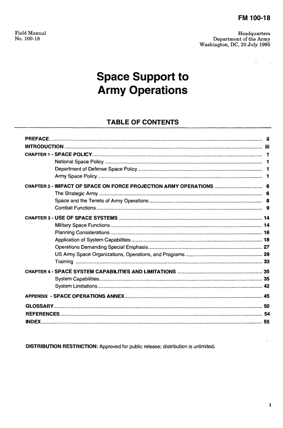
Space Support to
Army Operations
TABLE OF CONTENTS
PREFACE................................................................................ ii
INTRODUCTION.......................................................................... iii
CHAPTER 1 - SPACE POLICY............................................................... 1
National Space Policy........................................................ 1
Department of Defense Space Policy........................................... 1
Army Space Policy............................................................ 1
CHAPTER 2 - IMPACT OF SPACE ON FORCE PROJECTION ARMY OPERATIONS........................ 6
The Strategic Army........................................................... 6
Space and the Tenets of Army Operations...................................... 8
Combat Functions............................................................. 9
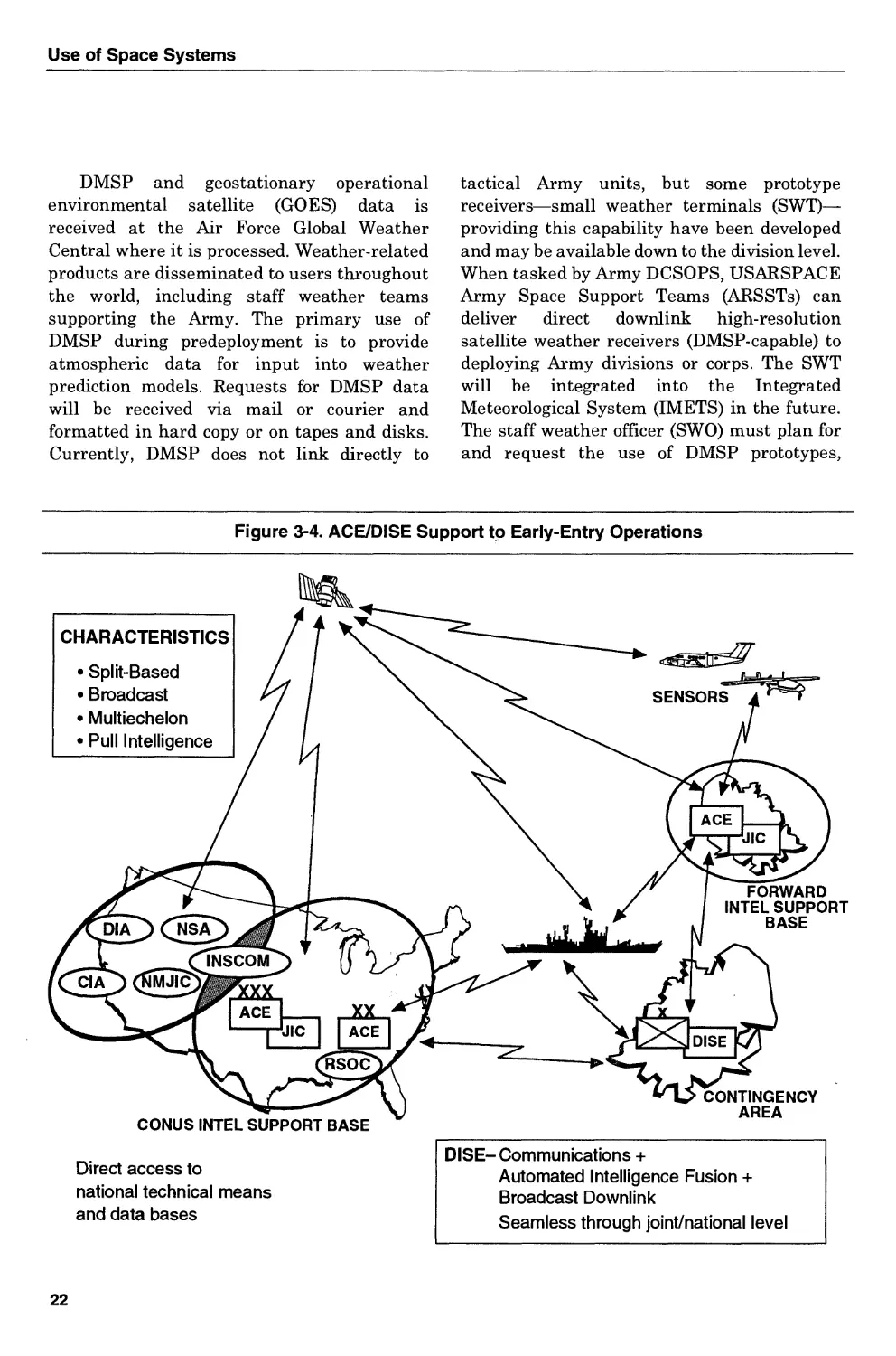
CHAPTER 3 - USE OF SPACE SYSTEMS.........................................................14
Military Space Functions.......................................................14
Planning Considerations........................................................16
Application of System Capabilities.............................................18
Operations Demanding Special Emphasis..........................................27
US Army Space Organizations, Operations, and Programs..........................29
Training ......................................................................33
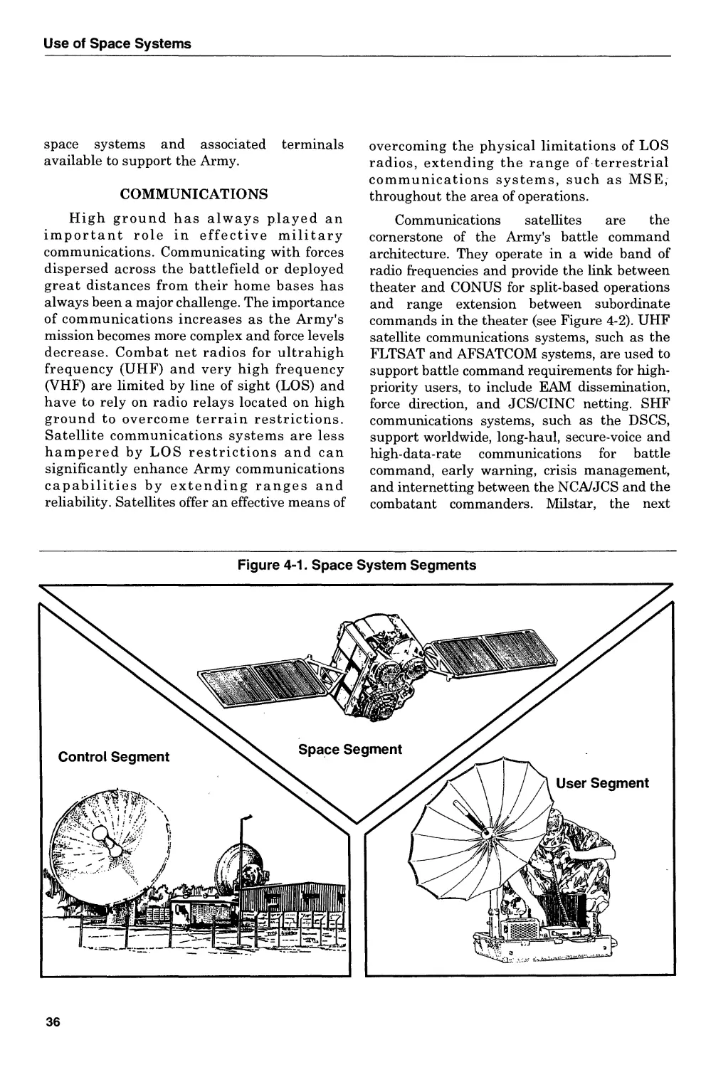
CHAPTER 4 - SPACE SYSTEM CAPABILITIES AND LIMITATIONS....................................35
System Capabilities............................................................35
System Limitations.............................................................42
APPENDIX - SPACE OPERATIONS ANNEX..........................................................45
GLOSSARY...................................................................................50
REFERENCES.............................................................................. 54
INDEX......................................................................................55
DISTRIBUTION RESTRICTION: Approved for public release; distribution is unlimited.
Preface
Гт very bullish on space. I want the Army to stay in space.
The Army is in space, and we're remaining in space.
------------------------------------------ General Gordon R. Sullivan
Chief of Staff, US Army, 1994
PURPOSE
FM 100-18 establishes doctrine for the Army's use of space, enumerates
current space system capabilities, and provides guidelines for the use and
application of space capabilities to support Army operations. It emphasizes the
enhancements that space assets provide in meeting numerous requirements of
land forces: surveillance, navigation, mapping, targeting, communications,
early warning, terrain and weather, to name the most common. In short, space
systems are essential to obtaining and transmitting vital information needed
in the planning and execution of military operations. This manual provides a
foundation for leader development, training, and space-related modernization
initiatives that support the force projection Army's missions and provide
soldiers with a decisive advantage across the full range of military operations.
SCOPE
The Army is involved in space because it can no longer effectively and
efficiently execute its missions and maintain a technological advantage
without exploiting space-based capabilities to meet worldwide command and
control, communications, and intelligence requirements. This document
focuses on the use of space capabilities across the full range of military
operations. In this regard, FM 100-18 is more than a doctrinal statement about
space support to the Army. It provides space support doctrine that is not only
consistent with current doctrine of the various mission areas, but should drive
the future development of doctrine within those areas. The bottom line is to
aggressively use space to support the attainment of terrestrial objectives. It is
relevant from the highest levels of command down to the soldier in the foxhole.
The proponent of this manual is HQ TRADOC. Send comments and
recommendations on DA Form 2028 directly to Commander, US Army
Training and Doctrine Command, ATTN: ATCD-HS, Fort Monroe, VA 23651-
5000.
Masculine pronouns in this publication do not refer exclusively to men.
ii
Introduction
The Army's land power is hinged in space.
General Gordon R. Sullivan
Throughout US history, the military services have fought to guard US
national interests on land, on sea, and in the air. Historically, whoever held
and used the “high ground” had a significant advantage over his adversaries.
While holding high ground in itself does not ensure victory, it has restricted the
enemy's freedom to maneuver. Space, the ultimate high ground, has joined
land, sea, and air as a medium in which national defense can be prosecuted.
Therefore, the Army has a vital interest in the farseeing aspects of space
technology.
Space offers the Army unique or enhanced capabilities to achieve land
dominance. Space systems provide communications, positioning and
navigational data, early warning, weather, environmental, and surveillance
and targeting capabilities that are essential for national security and the
prosecution of land warfare. Space capabilities are particularly important
where the operational area lacks the infrastructure to support Army
operations. These capabilities apply across the entire spectrum of military
operations, to include military operations other than war (MOOTW), and to all
echelons of command. In the post-Cold War era, Army forces' effective use of
space capabilities and products is as critical to global operations as land, sea,
and air power are today.
The US Army has always played an important role in exploring and
defending new frontiers. Its role in space is no exception. Army rocket
development and early space exploration first received impetus when Dr.
Wernher von Braun and other German scientists joined the Army's missile
effort in 1945. In the following years, the Army engineered the first US space
rockets and led the development of space technology.
In 1958, the Army space program became the nucleus of the newly created
National Aeronautics and Space Administration (NASA), whose task was to
direct all civilian space development activities. Later that year, NASA, using
an Army Redstone missile, launched the.first operational US satellite. In 1961,
another modified Redstone missile carried Commander Alan B. Shepard, USN,
the first American astronaut to reach space, into suborbital flight.
Although during the intervening years the Army's role and influence in
space activities declined as NASA and other civil and military agencies
assumed its space responsibilities, Department of Defense (DOD) established
the US Army Satellite Communications Agency in April 1961. The agency was
the single point of control to accomplish research, development, and production
Introduction
of both strategic and tactical satellite communications ground terminals for
use by all military services. In addition, the Army continued research and
development efforts that focused on air and strategic ballistic missile defense
and on the tactical applications of national space capabilities. The Army Space
Program Office (ASPO), established in 1973, was given responsibility for
leveraging national capabilities as part of the Joint Tactical Exploitation of
National Capabilities (TENCAP) Program. The result has been the fielding of
a number of systems that support tactical operations. The US Army Strategic
Defense Command (USASDC) represented the outgrowth of the Army's early
involvement in the Ballistic Missile Defense (BMD) Program.
The development of the Army's AirLand Battle doctrine in the 1980s
focused on a battlefield that was expanding in depth and lethality. Studies and
operations completed in the 1980s showed that space systems incorporating
maturing technologies could be used to support many of the Army's missions.
These studies identified the space-related technologies and capabilities
applicable to Army missions and functions. Army leaders used this information
to chart a course for developing and acquiring the necessary technologies and
capabilities. By-products of this effort resulted in the publication of The Army
Operational Concept for Space Operations in 1987 and the first version of The
Army Space Architecture in 1988. These two documents incorporated the most
promising ideas and space-related technologies that could be developed to
fulfill Army requirements.
In support of its evolving role in space, the Army formed additional
organizations to—
•Provide training and to perform combat development of potential space
technologies.
• Serve as the proponent for space-development activities.
• Provide operational support and interaction with unified operations.
•Perform the research, development, testing, and evaluation of strategic
and tactical BMD and other space-related technologies.
• Provide forces for space support operations for DOD.
In 1985, DOD established the United States Space Command
(USSPACECOM). A short time later, the Army Space Agency was created and
became the Army's representative to USSPACECOM. Designated the US
Army Space Command (USARSPACE) in 1988, it became the Army component
to USSPACECOM. In 1993, USARSPACE and USASDC were combined into
one organization designated the US Army Space and Strategic Defense
Command (USASSDC). Within this organization, USARSPACE remains the
operational component to USSPACECOM, and USASSDC remains the Army
leader in missile defense technology, continuing its research and development
to support both strategic and tactical missile defense systems.
The 1993 version of FM 100-5 recognizes the contribution of space to Army
operations. Under this emerging doctrine, space-related systems no longer
merely supplement and complement terrestrial systems; in many instances
they are the primary means, with terrestrial systems serving as backup. In
some instances, space systems will replace existing and programmed
iv
FM 100-18
terrestrial systems. This utility of space capabilities must be considered and
articulated in operational plans and programmatic decisions. The doctrinal
shift to a force projection Army has profound implications for the use of space
assets, as manifested during Operation Desert Storm and operations in
Somalia and Macedonia. Lessons learned from recent operations and emerging
conceptual and doctrinal changes dictate the full integration of space-related
capabilities into future operations. The Army will continue to “leverage”
existing space capabilities and exploit technological opportunities to improve
the execution of its missions in a global environment.
Associated space research and product development continue to provide
invaluable technologies applicable across the full range of military operations.
A variety of space systems is now available to support strategic
communications, early warning of missile launches, the National Command
Authorities (NCA), and the military services' reconnaissance requirements.
This involvement in space activities over the years has provided the Army an
appreciation of space and an understanding of the value of space systems to its
operations.
In the past, space assets primarily supported echelons above corps. This is
no longer true. Today, most missions and every soldier on the battlefield can
benefit from space systems and products. To improve its effectiveness and
increase the survivability of its forces, the Army must continue to exploit the
military potential of space systems.
In the future, because of the speed with which a crisis may erupt and the
lethality of the weapons used, the need for better and near-real-time
information will be more demanding. Space systems will provide the Army the
leverage needed to conduct more effective and efficient missions in the area of
information operations (IO). Space-based assets can provide decision makers
with a more accurate assessment of the enemy situation before a state of war
is declared or a decision made to commit land forces, thereby enhancing the
possibility of successfully achieving the first objective of the Army: deterrence
without a round expended or the loss of one life. Only through space can the
information needed to assure such a victory be distributed in the time,
quantity, and array required. Exploitation of space-based assets requires
diligent planning to ensure accurate and timely information is available when
needed. Every effort should be made during peacetime to ensure that the Army
force of the future will be properly equipped, trained, and manned to conduct
successful IO or any other military operations.
v
Chapter 1
Space Policy
Army doctrine has evolved to match the changing world
environment. The doctrinal shift to a force projection Army has
profound implications that necessitate the exploitation of space
capabilities that will enhance mission accomplishment. This chapter
provides an explanation of national, DOD, Joint Staff, and Army
space policies. It addresses the external forces and trends that shape
Army doctrine in general and at the same time suggests the increased
importance of space to the Army as it poises itself to execute national
military strategy.
NATIONAL SPACE POLICY
The National Space Policy states that the
primary goal of space activity is to ensure the
security of the United States. It recognizes the
importance of space in achieving national
security, scientific, technical, economic, and
foreign policy goals. It contains guidelines and
implementing actions relative to the conduct of
space programs and related activities.
DEPARTMENT OF DEFENSE SPACE POLICY
DOD space policy focuses on operational
capabilities that enable the military services to
fulfill national security objectives. It
enumerates three space-related efforts that
guide the military services: (1) deter or, if
necessary, defend against enemy attack;
(2) enhance the operations of US and allied
forces by employing space systems; and
(3) ensure that forces of hostile nations cannot
prevent our use of space. These space-related
efforts include protecting the peace and
decreasing the incentives for attack and enemy
escalation. Joint Chiefs of Staff (JCS) Pub 3-14
provides the doctrine and principles by which
military forces should plan, prepare, and
execute military space operations. JCS Pub 0-2
defines the Army's responsibilities for space
operations as follows:
• To organize, train, equip, and provide
Army forces to support space operations.
• To develop, in coordination with the other
military services, tactics, techniques, and
equipment employed by Army forces for
use in space operations.
• To conduct individual and unit training of
Army space operations forces.
• To participate in joint space operations,
training, and exercises as mutually agreed
to by the services concerned or as directed
by competent authority.
ARMY SPACE POLICY
Current Army space policy is consistent an evolution of Army involvement in space. It
with national and DOD policy and stems from articulates the Army's position and serves as a
1
Space Policy
framework for the Army's future direction in
space based on the premise that space products
are becoming an increasingly important
element of successful military operations. The
Army's space policy calls for—
•Accessing national, civil, military, allied,
and commercial space products.
•Exploiting space-based assets, capabilities,
and products.
• Conducting space and space-related
activities that enhance operational support
to warfighters.
• Influencing future space system design
and developmental initiatives.
• Organizing and training forces to take full
advantage of space-based capabilities.
To accomplish these policy objectives, the
Army must adapt all the elements of doctrine,
training, leader development, organization,
materiel development, and soldiers (DTLOMS)
to capitalize on the unique capabilities afforded
by space systems. In so doing, the Army can
successfully exploit the potential of space to
support operations and maintain land force
dominance well into the twenty-first century.
The Army's space capabilities to support its
missions will evolve from the use of ground
receivers in the near term to direct satellite-to-
user linkage in the far term. The
implementation strategy may be summarized
as follows:
• In the near term, acquire receivers to take
advantage of or leverage currently deployed
space system capabilities.
• In the midterm, acquire or develop processors
for more complete integration and direct
interface with space systems.
• In the far term, influence the development
of future space systems that have been
totally or partly designed to meet specific
Army requirements.
These three phases occur concurrently, not
sequentially. To gain the advantages in the mid
and far terms, appropriate actions must be
initiated in the near term that will result in the
desired outcome.
EXTERNAL FORCES AND TRENDS
The external forces and trends that have
had a major influence in shaping our space
doctrine include—
• New military strategy.
• Continued regional instability.
•The broad spectrum of missions.
•Worldwide infusion of advanced technology.
• Declining resources.
•Joint, interagency, and multinational
operations.
New Military Strategy
The US has adopted a new, regionally
oriented military strategy as a result of
fundamental changes in our environment both
at home and abroad. Today, the Army must be
able to specifically design force packages to
satisfy diverse worldwide missions. The new
strategy requires the Army to have capabilities
unique to this environment—supporting
combat operations as well as MOOTW. The
transition to a force projection Army from one
oriented to fighting Warsaw Pact forces in
Central Europe requires development of
greater versatility and flexibility.
Implementing this new strategy requires the
Army to fully exploit the capabilities of existing
and programmed systems, including space-
based assets.
The international security environment
has undergone fundamental changes since the
collapse of the Soviet Union. The dissolution of
the Warsaw Pact has created numerous power
voids, government upheaval, and a period of
uncertainty, expanding opportunities for the
US and other nations to form new international
relationships. While US relationships will
center around those nations that share
fundamental moral, political, and security
interests, the US may enter into coalitions with
other nations on short notice. Space systems
can provide and facilitate the exchange of
information required to support and sustain
multinational and coalition operations.
Continued Regional Instability
Political instability, divergent political
interests, and economic disparity among and
2
FM 100-18
within nations may result in increased
economic or political competition, leading to
acts of terrorism, insurgency, and regional
conflict that involve armed confrontation. To
protect US national interests, the Army may be
deployed into areas with little or no
infrastructure to assist in the restoration of
stability and regional balance. Space systems
can enhance Army capabilities during
operations in remote or underdeveloped
regions and may be the only feasible solution to
unique requirements associated with this
environment and the specific Army mission.
For example, space systems can provide an
intratheater communications infrastructure
when one does not exist or is insufficient to
support operations. Likewise, space systems
can be used to produce image products to
partially satisfy mapping requirements when
maps do not exist or are outdated.
Broad Spectrum of Missions
The US will face an increasingly broad
spectrum of challenges across the full range of
military operations. While the Army's focus
remains on the missions of the warfighter, it
will assume greater responsibilities for
MOOTW, such as noncombatant evacuations,
nation building, security assistance, peace-
keeping, disaster relief, countering drugs, and
search and rescue missions. These operations
can have an importance equal to combat
operations because they can preempt or
prevent crisis situations from arising by
reestablishing regional stability. The diversity
of these operations provides a special challenge
since many will likely be conducted in regions
with little or no infrastructure to support the
Army. Space-based systems provide options
that permit commanders to mitigate conditions
that may be found in austere environments.
Worldwide Infusion of
Advanced Technology
The infusion of advanced technology into
military capabilities will continue. More nations
will acquire significant numbers of modern lethal
weapon systems and develop more capable
armed forces. The proliferation of weapons and
technology, including space capabilities, may
allow less influential nations to become more
assertive in international affairs. The Army must
preserve, expand, and exploit its space
capabilities to ensure land warfare dominance in
the face of spreading technologies.
Declining Resources
The Army's fiscal resources probably will
decline over the next few years, resulting in a
smaller force. Consequently, the Army must
optimize the value of each dollar to ensure a
competitive edge in warfare. The Army must be
more selective in determining which systems
and technologies to pursue in order to hedge
against the unknown and to ensure that they
develop only capabilities not already available
from other DOD activities. Space systems can
enhance the Army's operational effectiveness
and mitigate the impact of a smaller force. Use
of space capabilities will also support the
Army's requirements for versatility and agility.
These systems have applications in peacetime
such as nation assistance, humanitarian
assistance, disaster relief, contingency plan-
ning, and training. They also provide support
unique to combat operations.
Joint, Interagency, and
Multinational Operations
To protect US national interests, the Army
will be involved with other military services,
government departments and agencies (for
example, Departments of State, Transportation,
Interior, and Commerce and the Drug
Enforcement Agency), and other nations and their
forces. Space system capabilities, such as
communications, multispectral imaging, and
position/navigation (POS/NAV), enhance inter-
operability and facilitate coordination during joint
and multinational operations. Space-based
systems provide the capabilities and infra-
structure required to operate in an austere
environment. Satellites, when combined with
terrestrial communications systems, can provide
worldwide responsiveness and the inter-
operability needed for information exchange.
Access to these assets by joint, interagency, and
multinational organizations facilitates coordina-
tion, standardization, and understanding of intent
across the full range of Army operations.
3
Space Policy
NATIONAL MILITARY
STRATEGY (NMS)
The Army must support requirements that
may result from three NMS fundamental
demands:
• Peacetime engagement.
•Deterrence and conflict prevention.
• Fight and win our nation’s wars.
In addition to these requirements, the NMS
has necessitated new Army doctrine as
contained in FM 100-5.
US national military strategy continues to
be based on deterrence. It emphasizes force
projection with capability across the full range
of military operations. The Army must be more
versatile, providing an increased number of
strategic options for the NCA, including the
protection of the US, its allies, and deployed US
forces. The Army's roles in support of the
unified commander in chiefs (CINC)
implementation of the NMS include—
• Providing forces for forward presence.
•Maintaining combat-ready forces for power
projection.
• Maintaining forces for reinforcement.
•Participating in interagency operations
and providing support to civil authority.
•Contributing to regional stability through
support to allies.
To execute the NMS, the Army must
maintain forces to support the projection of US
power and influence anywhere in the world.
This means that the Army must be capable of
full-dimensional operations, employing all
means available to accomplish the mission
decisively and at the least cost. Campaigns,
whether in support of combat operations or
MOOTW, will begin and end with the
movement of troops and equipment. Land, sea,
air, and space capabilities will be employed as
part of a joint, interagency, or multinational
force to achieve the desired end state, requiring
an Army capable of executing different types of
missions simultaneously. To accomplish these
missions, the Army must project its power and
influence from the continental United States
(CONUS) or other staging areas to anywhere in
the world. Force projection requirements to
support this strategy include timely worldwide
reconnaissance and surveillance; effective
communications and dissemination of infor-
mation; capability to manage split-based
operations; accurate location of assets and
forces; and the ability to deny the enemy
knowledge of friendly operations, capabilities,
or intentions. This strategy requires a new
definition of intelligence readiness, calling for
the commander to develop broad knowledge on
priority contingency areas, update those data
bases regularly, and be prepared to drive the
intelligence system to surge in support of
emerging missions.
The use of space capabilities increases the
Army's ability to satisfy these force projection
requirements. Space capabilities are a vital and
integral component of each of the Army's
strategic roles and are important “force
multipliers” for operational and tactical missions.
Satellites on orbit are mission-ready and
responsive to user requirements around the
world. The Army can use satellites to acquire and
distribute timely information that reduces the
level of uncertainty about a given situation or
condition without revealing interest or intent.
The worldwide presence of space systems
enhances stability by permitting the US and its
allies to see the area of operations and provides
early warning of operations adverse to US
interests. This information can be used to
support both combat and MOOTW.
During combat operations, Army forces
will be employed and synchronized with a wide
range of systems and organizations to defeat
the enemy. Simultaneous attacks throughout
the battle area are designed to seize the
initiative, control the enemy's tempo, and
destroy his will to fight. At each echelon, deep,
close, and rear operations are arranged to
ensure the mission is accomplished as rapidly
as possible. The earlier Army forces can cause
enemy operations to begin to fail, the more
rapidly enemy follow-on operations and
exploitations are jeopardized, thus limiting the
enemy's chance for success.
The importance of MOOTW is increasing.
Army forces conduct these types of operations as
4
FM 100-18
part of the NMS to prevent or preempt situations
that, although less threatening, could eventually
affect US access to critical regions of the world,
our credibility among our allies, or the confidence
of other nations in our abilities and resolve. In the
future, development of campaign and operations
plans may be based entirely on MOOTW
requirements. During MOOTW, space systems
provide essential information to support security
assistance, nation building, disaster relief, and
humanitarian assistance. Satellites also provide
the means for assessing disasters, predicting crop
growth, and analyzing a nation's infrastructure
(for example, fines of communication, sources of
energy and power, and trafficability situations).
These space capabilities, if implemented, can
complement the Army's ability. They support US
interests, both at home and abroad, and often are
an integral part of the overall MOOTW campaign
plan.
5
Chapter 2
Impact of Space on
Force Projection Army Operations
Due to the fact that space systems are “force multipliers” able to
support missions across the full range of military operations,
commanders at all levels must understand space capabilities and fully
integrate them into Army operations. This chapter describes how
space systems impact the full range of force projection Army
operations. It relates the value added by space to the Army's
characteristics and addresses the relationship between space and the
tenets of Army operations. Finally, it discusses the impact of space on
the combat functions: intelligence, maneuver, fire support, air
defense, mobility and survivability, logistics, and battle command.
THE STRATEGIC ARMY
Faced with challenges that are constantly
changing the range of operations, today's Army
must be prepared to quickly adapt and to
deliver decisive military force upon demand.
Only by employing every available asset will
the strategic Army succeed. Mission
accomplishment depends upon how well the
Army exploits the use of space systems and
space forces and support from Air Force, Navy,
Marine Corps, and allied and coalition forces.
Participation in joint and multinational
training exercises provides the Army an
opportunity to refine its interoperability and
deploy ability plans and strategic role.
Exploitation of space capabilities is a must if
political, economic, diplomatic, and national
security interests are to be assured
strategically. Space capabilities enhance the
Army's ability to be better prepared, better
equipped, and more capable of—
• Conducting full-dimensional operations.
• Exercising more efficient and effective
battle command when participating in
joint, multinational, United Nations, or
interagency force-level training exercises.
•Meeting the “deployable” demands of a
force projection Army.
•Responding to expansible requirements
associated with changes and surges that
may occur during various phases of
military operations.
•Ensuring the combat power needed to
assure a decisive victory in achieving the
overall national security strategy.
CAPABLE OF FULL-DIMENSIONAL
OPERATIONS
Space-based assets provide the force
multipliers needed to successfully conduct full-
dimensional operations. Today's Army must be
capable of conducting a variety of military
operations on short notice and at minimum cost
in lives and other resources. The most efficient
and effective means available must be
employed to accomplish this goal. Space
systems offer enhancements in many of the
mission areas that are critical to success.
Battle command, synchronization of resources,
enhanced information dissemination, parallel
6
FM 100-18
planning, concentration of fires, and the
massing of other combat power are but a few of
the benefits that are available and may be
realized through the use of space systems.
Commanders and staff planners at every level
should become thoroughly familiar with the
space assets available and ensure their use in
every aspect of the planned operations.
TRAINED TO FIGHT AS PART OF A
JOINT OR MULTINATIONAL FORCE
The Army will become more involved with
other services, national agencies, and nations to
protect US national interests. The ability of the
Army to conduct a wide variety of operations
under joint/multinational command and control
relationships will be essential in future
operations. The Army must be capable of
supporting war as well as MOOTW
requirements. The diversity of missions, coupled
with anticipated budget restrictions, mandates
that the Army do more with less. As a result, it
must use all available training facilities,
opportunities, and capabilities to increase the
operational effectiveness of the force. The use of
space assets enables the Army to support this
wider range of missions with increased
effectiveness and efficiency.
DEPLOYABLE
Force projection is the cornerstone of the
successful implementation of the national
military strategy. No longer can the Army plan
on being in the area of operations prior to a crisis.
Operations will start with the movement of forces
and equipment to the area of operations. Space
systems currently in orbit are already deployed
and can support the Army prior to and during
deployment, providing information that reduces
ambiguity and improves decision making.
Satellites provide the initial communications,
surveillance, and weather system infrastructures
to support deployment. They gather information
and provide a means for rapid dissemination of
data to appropriate echelons of command. Data
from space assets is integrated with other sources
of information to facilitate mission planning and
ensure knowledgeable entry into the area of
operations. Additionally, data from space
systems facilitates in-transit visibility and total
asset visibility. Space systems permit accurate
tracking of critical equipment en route to the
deployment area. Space systems also enhance
the Army's deployability by providing
information to accurately tailor the force
package, potentially reducing the amount and
size of ground-based equipment that must be
transported. The forces and equipment deployed
can also be reduced through split-based
operations, facilitated by the capabilities of space
systems to provide and transmit information.
CAPABLE OF DECISIVE VICTORY
Lethality is essential for the rapid defeat of an
adversary. The ability of the commander to
effectively command and control forces and to see
the battlefield, regardless of size or maturity,
permits Army forces to react faster than the
enemy. This quick reaction can be obtained and
enhanced by the application of space-related
capabilities. The use of space-based
communications and intelligence data, accurate
position and navigation information, and weather,
terrain, and environmental monitoring directly
enhances target acquisition and engagement
opportunities and improves weapon system
performance and lethality for Army forces. The
capabilities of space systems to support
information operations will also contribute to
decisive victory by allowing our forces to be
informed simultaneously, thereby enhancing their
responsiveness and improving battle command.
EXPANSIBLE
The Army must be able to meet several
threats to US national interests simultaneously.
This may require expanding the size of the active
Army by activating reserve components, creating
new units, and mobilizing the industrial base to
support increased requirements. Likewise, space
assets can be reallocated, moved, leased, or
purchased to improve the operational
effectiveness of the expanding force. The use of
civil and commercial systems, on-orbit spares, and
a robust launch capability will increase the
number of space assets available to support Army
users.
7
Impact of Space Operations
SPACE AND THE TENETS OF ARMY OPERATIONS
By collecting data and disseminating
information, space capabilities support the
tenets identified in FM 100-5: initiative, agility,
depth, synchronization, and versatility.
INITIATIVE
Space systems provide intelligence support
for indications and warnings to US forces—an
essential element for supporting the NMS. In
an environment in which uncertainty and
instability are major threats, global situational
awareness is critical. Satellite systems help
commanders see the enemy situation,
understand terrain, know the current and
future weather conditions, and accurately
position forces and track resources. Not only
does this information reduce the element of
surprise and the vulnerability of the force, it
facilitates planning by allowing military forces
to anticipate events. Once planning is
completed, communications satellites provide a
means to transmit information necessary to
execute the plan. The capability to seize the
initiative with certainty and to act decisively as
a result of near-real-time information may
exhaust the enemy's options and avert further
escalation.
AGILITY
Access to data from space systems enhances
the commander's situational awareness and
provides a better understanding of the battlefield,
which, in turn, facilitates decision making. The
timely information afforded by space-based
systems improves the ability of Army forces to act
and react faster than hostile forces. Space-based
communication assets provide the connectivity
required to transmit the necessary information to
support command and control of maneuver
elements over extended distances, which further
enhances the agility of the force. Positioning
information from Global Positioning System
(GPS) satellites can be used to help reduce
fratricide, facilitate force positioning, and enable
commanders to track resources throughout the
area of operations. These capabilities enable
commanders to synchronize operations and
ensure concentration of effort at the right time
and place.
DEPTH
Space capabilities ensure vital coverage of the
battle space. Additionally, they provide the
multiplicity of data needed to support intelligence,
targeting, navigation, weather, terrain,
environmental monitoring, and command and
control functions. Satellites enable commanders to
see the area of operation and battle space in
sufficient depth (deeper than land or air platforms)
and detail to anticipate likely enemy options and to
evaluate the effectiveness of friendly operations.
This extension allows the Army to locate and
identify enemy assets, plan operations that will
disrupt the enemy's tempo, and conduct
simultaneous attacks throughout the battle space.
In force projection operations, information
broadcast from satellites will permit simultaneous
situational awareness throughout the battlefield.
SYNCHRONIZATION
Space capabilities facilitate unit
coordination and management of critical
resources necessary to ensure that the end state
identified in the campaign plan is achieved.
Satellites play a key role in synchronization.
They permit forces to share information and
enable commanders to combine resources and
operations at the decisive time and place.
Sequencing and combining operations reinforce
and amplify the effects of each specific
operation and ensure unity of effort in the
application of resources.
VERSATILITY
The diverse and multifunctional array of space
systems offers unique advantages that increase
the Army's versatility and can have a dramatic
effect on all Army missions. Satellites are in orbit,
have worldwide coverage, and can support
training, MOOTW, and combat equally well. The
POS/NAV satellites—NAVSTAR GPS—enable
anyone with a passive receiver to know his position
more accurately. Military and civilian
communications satellites offer worldwide links
with virtual line of sight to anyone. Weather and
terrain information is available from Defense
Meteorological Satellite Program (DMSP) and civil
environmental satellites, such as the US-launched
civil earth imaging satellites (Landsat), Japanese-
launched marine observation satellite (MOS-1),
8
FM 100-18
and France’s Systeme Probatoire d’Observation de
la Terre (SPOT) satellite, to support intelligence
preparation of the battlefield (IPB), planning, and
rapid decision making. Space systems provide
reconnaissance, intelligence, surveillance, and
target acquisition (RISTA) and communications
support to tactical commanders. The Army's
TENCAP Program provides the interface between
space-based intelligence and electronic warfare
(IEW) sensors and the all-source analysis system
(ASAS) within the analysis and control element
(ACE) located at echelons above corps (EAC),
corps, divisions, separate brigades, and armored
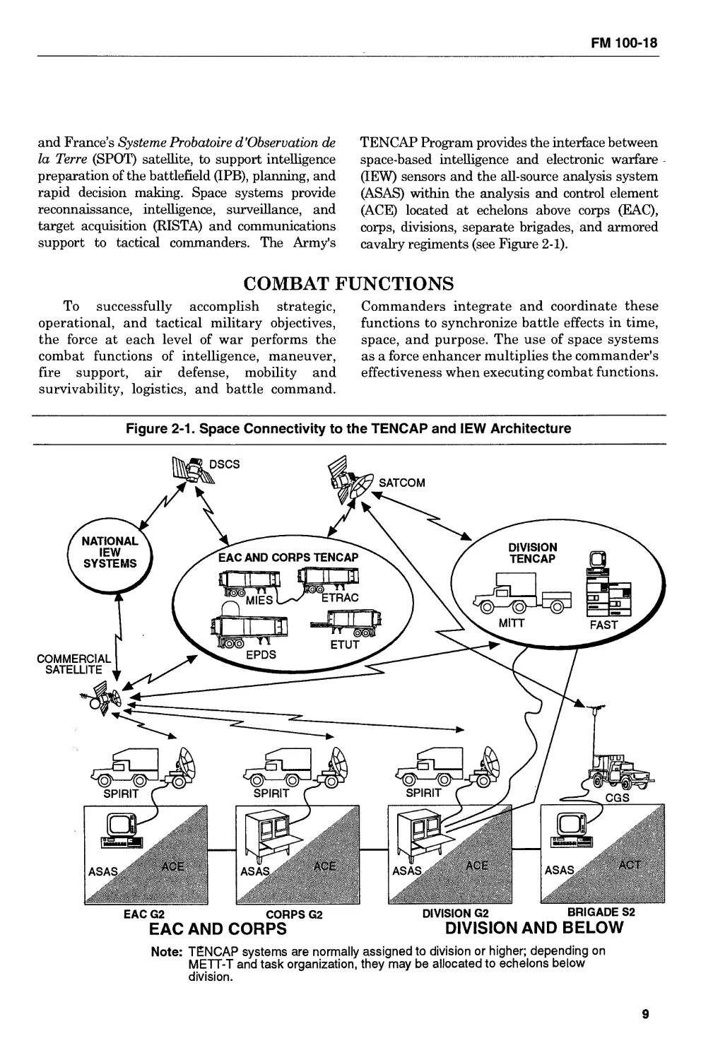
cavalry regiments (see Figure 2-1).
COMBAT FUNCTIONS
To successfully accomplish strategic,
operational, and tactical military objectives,
the force at each level of war performs the
combat functions of intelligence, maneuver,
fire support, air defense, mobility and
survivability, logistics, and battle command.
Commanders integrate and coordinate these
functions to synchronize battle effects in time,
space, and purpose. The use of space systems
as a force enhancer multiplies the commander's
effectiveness when executing combat functions.
Figure 2-1. Space Connectivity to the TENCAP and IEW Architecture
EAC AND CORPS
DIVISION AND BELOW
Note: TENCAP systems are normally assigned to division or higher; depending on
METT-T and task organization, they may be allocated to echelons below
division.
9
Impact of Space Operations
INTELLIGENCE
Intelligence is the collection of functions that
generate knowledge of the enemy, weather, and
geographical features that a commander requires
in planning and conducting operations. It is
derived from an analysis of the information
provided by multiple sources on the enemy's
capabilities, intentions, vulnerabilities, and the
battle space environment.
Army commanders use intelligence, electronic
warfare, and counterintelligence support to
conduct combat operations. The intelligence cycle
phases of directing, collecting, processing, and
disseminating place tremendous demands on
command, control, and communications,
reconnaissance, and surveillance assets, which are
critical to the intelligence effort. Space systems
provide special advantages for IEW operations.
Dedicated and nondedicated ground,
airborne, and space systems are employed to
provide critical intelligence functions and
subfunctions support. Communications
satellites support the flow of all types of
information and intelligence connectivity to all
IEW users, improved communications security,
fewer terrain-dependent operations, increased
capacity, less downtime for movement, global
coverage, more survivable redundant systems,
and continuity of service. On-orbit position
location and navigation systems provide the
IEW system accurate and timely data needed
to support targeting and weapons delivery.
Surveillance and reconnaissance efforts
are a part of national intelligence gathering
and the systematic observation process.
Surveillance operations are effected to collect
information continuously from the air, land,
and sea. Reconnaissance operations are
directed toward specific targets. Through
surveillance and reconnaissance, varied data,
such as meteorological, hydrographic,
geographic, electronic, and communications
characteristics, can be collected on any given
area of the earth's surface.
The tactical commander will need to gain
timely intelligence from the full integration of
national and theater assets. The ability of
theater or national intelligence sources to
fulfill tactical intelligence requirements and to
remain responsive to dynamic, lower echelon
needs is key. Force projection operations need
accurate and responsive tactical intelligence.
Intelligence preparation must begin as early as
possible to allow commanders to develop
adequate plans. The deploying force achieves
this through split-based operations, which
integrate CONUS-based national systems with
forward deploying tactical systems.
MANEUVER
Maneuver is the employment of forces on the
battlefield through movement and direct fires, in
combination with fire support, to achieve a
position of advantage in respect to enemy ground
forces in order to accomplish the mission. It
pertains to all combat, combat support, and
combat service support. Space systems to support
maneuver focus primarily on force enhancement
to improve the effectiveness of combat forces.
Forces must be capable of operating on a highly
mobile, nonlinear lethal battlefield, continuously,
night and day, in all weather, on any terrain.
Space offers an added dimension to maneuver
capabilities of the force. Space assets provide a
global view of theaters of conflict, an operational
view of the battlefield, accurate movement, and
the ability to assess the terrain and weather,
locate enemy forces, and help determine their
vulnerabilities and intent. Space assets also
assist in deceiving the enemy, expediting
maneuver, and striking the enemy throughout
the full depth of the battlefield. Near-real-time
assessment of the location and progress of
subordinate units enables the commander to
rapidly shift or reinforce the main effort, exploit
enemy vulnerabilities, and sustain the
momentum of the force. Combat forces benefit
directly from space capabilities. Multicapable
sensors and navigation devices facilitate
command and control of ground maneuver forces
and provide the commander with knowledge of
the enemy and terrain. Regardless of the terrain
or distance, satellites provide a communications
link, thus allowing the commander to exercise
effective command and control. Space systems
help the commander to see deep, move fast, and
engage the enemy across the breadth and depth
of the battlefield.
10
FM 100-18
FIRE SUPPORT
The fire support system is the collective and
coordinated use of target acquisition data,
indirect-fire weapons, armed aircraft (less attack
helicopters), and other lethal and nonlethal
means against ground targets in support of
maneuver force operations. It includes artillery,
mortar, and other non-line-of-sight fires, naval
gunfire, close air support, and electronic
countermeasures. Space systems, due to their
unique high-ground vantage point, provide data
on terrain and weather as well as
communications capabilities, allowing fire
support systems to operate in a wide range of
geographic circumstances and in all weather
conditions. Space systems integrated with
intelligence systems provide target acquisition,
identification, and tracking information to fire
support control systems. The range, flexibility,
and speed provided by space systems
complement the technologies employed on the
fast-moving nonlinear battlefield.
Access to satellite communications provides
secure, robust range extension of tactical
communications nets to maneuver commanders;
GPS satellites provide highly accurate, real-
time, three-dimensional positioning and
navigation data; weather satellites scan the
battlefield and transmit reports' and
atmospheric profiles from space; and other earth
resource satellites produce topographic
products. All are used to assist battlefield
movement and to provide other critical fire
support data needed to destroy, neutralize,
suppress, degrade, or disrupt threat formations
and systems in support of the maneuver
commander.
AIR DEFENSE
Tactical air defense artillery units have the
mission of nullifying or reducing the
effectiveness of enemy attack or surveillance
aircraft and/or missiles. Strategic air defense
forces have the mission of providing attack
warning and attack assessment of air and
ballistic missile attacks on North America. A
family of weapons is employed to provide the
needed air defense coverage since no single air
defense system is capable of protecting the
wide variety of critical strategic and tactical
assets that are potential targets for the enemy.
A mix of ground, sea, air, and space-based
sensors provides early warning, detection,
tracking, discrimination, identification,
targeting, and other vital information to the
force. Communications satellites allow for
wide-area-surveillance net broadcasting, near-
real-time targeting transfer, and command and
control over extremely large areas. Space-
based position location and navigation systems
greatly enhance air defense operations with
worldwide, accurate position location, which
can be integrated with near-real-time
intelligence and accurate weather and terrain
data to give the maneuver force commander
complete situational awareness.
MOBILITY AND SURVIVABILITY
Mobility and survivability describe the
functions associated with providing friendly
forces freedom of movement over battlefield
terrain against obstacles while denying the same
to the adversary. These functions also reduce
friendly force vulnerability to the effects of enemy
weapon systems and natural occurrences. Space
system capabilities offer considerable
enhancements to the success of mobility and
survivability missions. Multicapable sensors,
navigation systems, and satellite
communications facilitate command and control
of widely dispersed forces with the transfer of
timely intelligence and information data. Space
observation platforms and sensors provide
commanders with an operational view of the
battlefield, which significantly adds to the ability
to detect natural and man-made obstacles,
ensuring timely information on routes, bridges,
water-crossing sites, employed obstacles, and
minefield locations. Weather, terrain, and
environmental monitoring systems give
information on terrain features, obscurants, and
trafficability, which can pose mobility
restrictions to the movement of large forces and
on lines of communication. Topographic products
and information provided through the use of
space-based imagery intelligence maps, charts,
overlays, and digital terrain data bases support
precise positioning of artillery, command, control,
and communications, and intelligence systems.
Also, space-supported topographic products can
11
Impact of Space Operations
assist in the precise positioning of obstacle zones,
belts, and groups to turn, fix, block, and disrupt
the enemy. Position location and navigation
systems provide increased navigation capability,
which enhances maneuverability and
responsiveness.
LOGISTICS
Logistics are those functions directly
related to the development and maintenance of
maximum combat power through the
sustainment of combat forces. Included are
personnel service support, health services,
general supply, field services, maintenance,
transportation, facilities, and quality of life. At
the tactical level, logistics focus on the combat
service support (CSS) functions of arming,
fixing, fueling, manning, moving, and
sustaining soldiers and their equipment.
Logistics support must be flexible enough
to support a force projection force operating on
widely dispersed battlefields anywhere in the
world under varying climatic and terrain
conditions and with varying degrees of host
nation support and infrastructure. This
support will require a mix of sustaining base
assets capable of pushing supplies and
maintenance assets forward and forward-
based logistics units capable of providing
immediate support as needed. To support
forces in this type of an environment, the
logistics system will require enhanced access to
timely, accurate intelligence and weather
information; improved logistics management
processes; more rapid, responsive, and reliable
transportation; better methods for assessing
battlefield damage; and robust and fast
communications and automatic data
processing support. Space systems will provide
these capabilities to help ensure success on the
future battlefield.
Space-based sensors identify sources for
water, food, and fuel. Support facilities such as
hospitals, major roads, airports, and seaports are
located to assist planners in determining the
level of support and the kinds of materiel needed.
Weather, terrain, and climatic conditions are also
studied to assess their impact on the logistics
system. Space-based systems provide force
enhancement capabilities that facilitate
information transfer and processing. Space-
based tracking devices maintain location of units
and supply bases and provide in-transit visibility.
Satellite communications provide a true split-
based capability, allowing logisticians to
communicate through data transfer from the
theater of operations back to the sustaining base
in CONUS or elsewhere. Position and navigation
devices allow tracking of the movement of
transportation assets and supplies, giving
commanders total asset visibility. This
capability, coupled with reliable space-based
communications, weather, terrain, and
environmental monitoring systems and space-
based intelligence, provides real-time command
and control to commanders. Commanders are
able to tailor and adjust CSS missions and assets
in response to the situational awareness gained
by having these capabilities available throughout
the area of operations.
Advanced automation equipment that
receives and transmits logistics information via
satellite systems allows for supply and
maintenance requests to be received,
consolidated, and requisitioned from appropriate
sources, facilitating unitized, modularly
configured packages. Near-real-time battle
damage assessment data provided through space
systems and advanced automation enables
maintenance efforts to concentrate on specific
problems, shortening the time required for
equipment to be returned to an operational
status.
Health services support, replacement
operations, casualty reporting, strength
accounting, finance services, chaplain activities,
postal services, legal services, public affairs, and
morale, welfare, and recreation activities are
enhanced through the application of
telecommunications, navigational satellite
transmission and reception communications
stations, computers, audio-video equipment,
satellite retransmission of television
programming, digitized facsimile telemetry, and
other space-produced capabilities. The use of
space-based assets will result in timely and
accurate processing of financial information in
support of contracting (local vender support),
12
FM 100-18
disbursing, payroll, and accounting information.
This capability will provide better management
information to commanders and increased
support to service members.
Rapid force projection from CONUS,
extended lines of communications, and potential
forcible entry into logistically bare-based areas of
operations require an Army logistics system that
is versatile, deployable, and expandable.
Administrative and logistical support, to include
split-based operations, will be more efficient and
timely due to utilizing space-based assets for
enhanced tracking, requisitioning, position
location and navigation, and imagery operations.
The improved CSS Battle Command System will
link logistical asset sources to the total
distribution system in the theater of operation
and CONUS. Using total asset visibility
combined with advanced information
communication flow will ensure that required
material will be immediately ordered, its location
identified, and its delivery tracked through
precise inventory accountability transfer.
Personnel replacement and medical support
operations will also improve significantly
because of enhanced capabilities derived from
using space assets.
All space-based systems deployed in support
of contingency operations or MOOTW have
weaknesses, limitations, and vulnerabilities.
Support plans—that is, the space operations
annex—must adequately identify and address
these factors to ensure maximum benefits are
realized from the space capability.
BATTLE COMMAND
Battle command is a properly designated
commander’s exercise of authority and direction
over assigned forces to accomplish a mission. It
specifies those functions that leaders must
perform in making sound and timely decisions
and in directing the activities of assigned and
supporting units. Information is the medium of
the battle command process, which results in
decisions and directives at every echelon and in
every branch. Battle command is the process of
acquiring information, assessing whether any
new actions are required, determining what
these actions should be, and directing the
appropriate one. Information about the mission,
enemy, terrain and weather, troops available,
and time (METT-T) is acquired through a variety
of means. The information is sent and received;
the means of communicating the information is
managed; and the information is maintained in a
form convenient to the decision-making process.
The battle command functions are necessary to
execute the intelligence, maneuver, fire support,
air defense, logistics, mobility, and survivability
combat functions. The battle command function
is substantially aided by the availability of space-
based systems. Space-based communications
equipment and the attendant ground terminals
offer communications support to facilitate
information transfer, for example, to transmit
orders, control measures, changes to orders, unit
status, and requests for support. Space-based
systems that identify targets can also determine
which fire support means should engage a target.
Space systems provide rapid information on the
enemy, his movements, and his intentions. They
can provide the commander with real-time and
near-real-time intelligence, target acquisition,
environmental and trafficability analysis,
logistics, and so forth. These capabilities enable
the combat, combat support, and CSS elements
to take appropriate actions and play a significant
role in enhancing efficiency and responsiveness.
13
Chapter 3
Use of Space Systems
As the Army continues its transition from a Cold War European-
oriented force, requirements of a force projection Army will be further
defined and new problems uncovered. Many of these requirements
can be met by using space systems. This chapter explains the Army's
doctrinal application of space systems and their capabilities to
support Army operations. It focuses on planning considerations and
the operational context of the space system capabilities further
described in Chapter 4. It describes, using joint terminology, the four
military space functions and the general planning considerations for
space support, from the strategic to the tactical levels, including joint
planning.
MILITARY SPACE FUNCTIONS
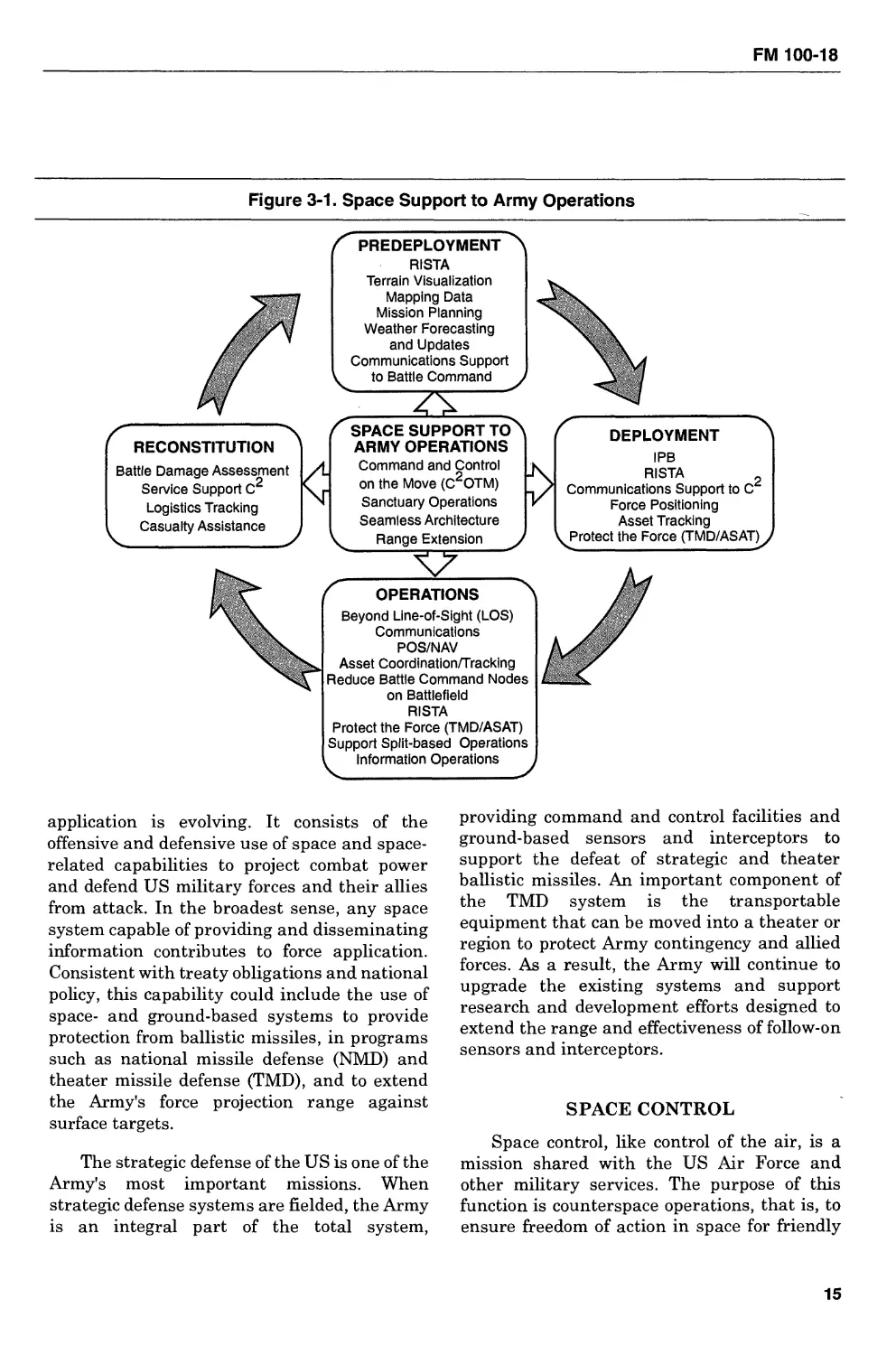
Army planners must be familiar with the
space support available and its capabilities, as
well as the procedures for requesting support
from space systems not directly allocated to or
supporting their operation (see Figure 3-1).
Personnel and equipment not organic to a
deploying unit must be made available to
support these operations. Required in many
cases is the reallocation or redistribution of
space assets or the development and
maintenance of contingency space support
packages for use by deploying units. To
describe the aggregate warfighting capability
offered to combat forces, space system
capabilities are further divided into four
military space functions: force enhancement,
force application, space control, and space
forces support. Each of these functions should
be considered during the initial stage of
mission planning.
FORCE ENHANCEMENT
The Army's involvement in space is largest
in this functional area. Force enhancement
involves space support that helps the land force
accomplish its terrestrial mission. It is
analogous to combat support with space
capabilities that improve the effectiveness of
forces across the full range of military
activities. It includes, but is not limited to,
communications, navigation, weather, terrain,
environmental monitoring, and surveillance
support. The efficiencies resulting from the use
of these space capabilities can have a dramatic
effect on Army operations: reducing
uncertainty, facilitating battle command, and
moderating the effects of friction and fog of
war. As one of the biggest users of satellite
systems—GPS receivers, satellite
communications (SATCOM) terminals,
multispectral imagery (MSI) processors, and
TENCAP systems—the Army is responsible for
articulating its requirements, influencing the
satellite design process, and acquiring ground
terminals to satisfy its space needs.
FORCE APPLICATION
Force application addresses the conduct of
combat operations from, in, or through space
with the intent to destroy terrestrial targets.
While force application capabilities from space
are limited, the role of space in force
14
FM 100-18
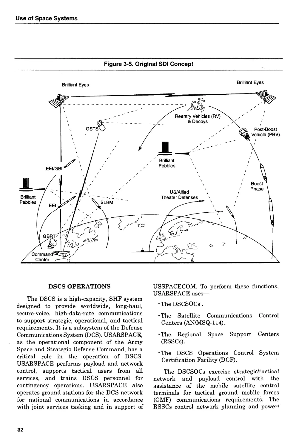
Figure 3-1. Space Support to Army Operations
application is evolving. It consists of the
offensive and defensive use of space and space-
related capabilities to project combat power
and defend US military forces and their allies
from attack. In the broadest sense, any space
system capable of providing and disseminating
information contributes to force application.
Consistent with treaty obligations and national
policy, this capability could include the use of
space- and ground-based systems to provide
protection from ballistic missiles, in programs
such as national missile defense (NMD) and
theater missile defense (TMD), and to extend
the Army's force projection range against
surface targets.
The strategic defense of the US is one of the
Army's most important missions. When
strategic defense systems are fielded, the Army
is an integral part of the total system,
providing command and control facilities and
ground-based sensors and interceptors to
support the defeat of strategic and theater
ballistic missiles. An important component of
the TMD system is the transportable
equipment that can be moved into a theater or
region to protect Army contingency and allied
forces. As a result, the Army will continue to
upgrade the existing systems and support
research and development efforts designed to
extend the range and effectiveness of follow-on
sensors and interceptors.
SPACE CONTROL
Space control, like control of the air, is a
mission shared with the US Air Force and
other military services. The purpose of this
function is counterspace operations, that is, to
ensure freedom of action in space for friendly
15
Use of Space Systems
forces while denying it to the enemy. It includes
the conduct of offensive and defensive space
operations to prevent an enemy's space forces
from gaining and maintaining space
superiority and to ensure survivability and
protection of friendly space systems. The
Army's role in this function will be from the
terrestrial perspective, such as jamming up/
downlink frequencies and attacking satellite
control nodes and facilities from the ground.
Our force projection Army will continue to
support the requirement for a counterspace
system to facilitate space control, assure space
support, and deter nations from attacking US
satellites. Access to a counterspace capability
by more nations may increase over time. The
impact could be significant. For example, the
destruction of US space-based surveillance
systems would limit the ability of commanders
at all echelons to see the battlefield clearly. A
commander's freedom of action can be
enhanced by counterspace operations that
provide freedom from space-based surveillance.
Space control facilitates mobilization,
deployment, and employment of Army units.
SPACE FORCES SUPPORT
The US Air Force has the primary
responsibility for space support, with other
services providing assistance as needed. This
function addresses the military infrastructure
to deploy and maintain military space systems.
It includes the forces and activities responsible
for launching, maintaining telemetry, tracking
and commanding space systems, recovering
spacecraft, and providing logistics support for
space systems and their ground control
elements. The Army has limited involvement
in this function.
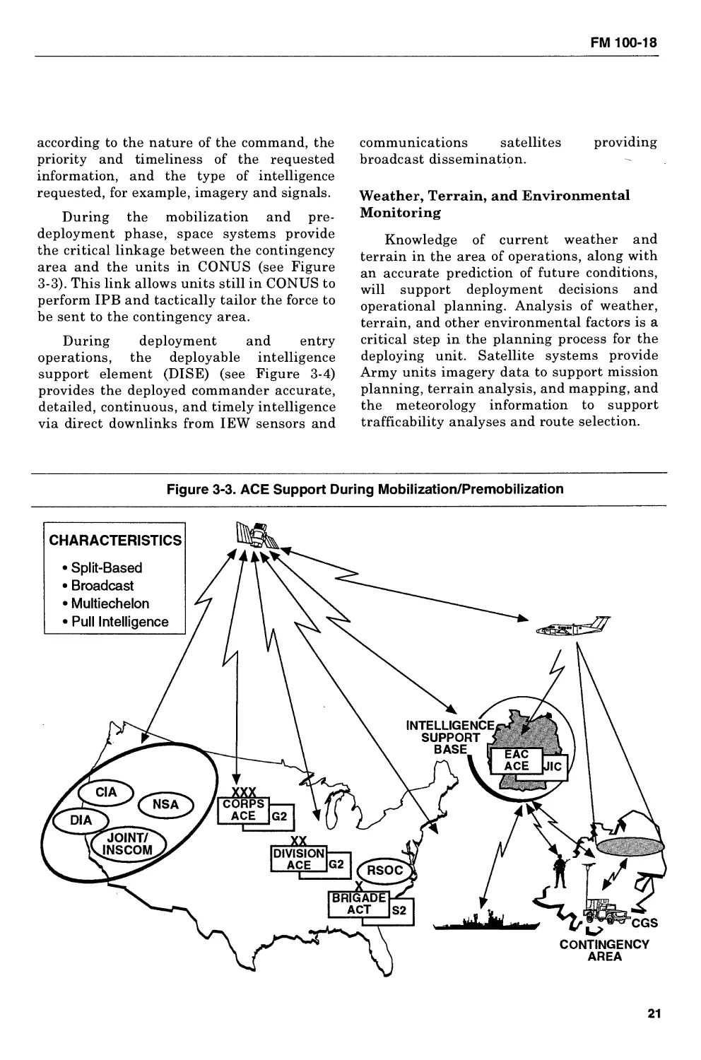
PLANNING CONSIDERATIONS
Joint Pub 0-2 sets forth principles and
policies to govern the joint activities and
performance of the US armed forces. It
provides guidance for use and employment of
space assets by the Army and other services.
Joint Pub 3-14 provides doctrine and principles
for joint forces to plan, prepare, and execute
military space operations. FM 100-5 is the
Army's keystone warfighting doctrine.
FM 101-5 provides the Army staff officer with
instructions on how to plan and document
Army operations. The space operations annex
to the operations plan is where the use of space
systems in support of Army operations should
be addressed. A template on what such an
annex should look like is provided at Appendix
A. Broadcast dissemination of intelligence and
targeting information (see Figure 3-2) is an
important element in providing commanders at
multiple echelons with a common picture of the
battlefield that facilitates parallel planning.
Broadcast provides a “dial-up” intelligence
capability for commanders. Additionally, space
systems enable commanders to “pull”
information from strategic through tactical
echelons.
STRATEGIC-LEVEL PLANNING
Space systems provide a global perspective
that supports strategic-level planning done by
all services. Planners at this level use space
capabilities to focus on reducing uncertainty.
The capabilities of space systems help strategic
planners to assess the risk of using the military
and other instruments of national power. The
information provided enables them to
formulate and coordinate appropriate
responses and to tailor the force for the
mission.
OPERATIONAL-LEVEL PLANNING
At the operational level, planners focus on
the design and conduct of campaigns and major
operations to accomplish the unified
commander or higher military authority's
strategic objectives. Projecting the force may
require the use of split-based operations in
which significant support is provided the
operational commander from elements that
remain in CONUS or elsewhere and do not
deploy to the theater of operations. During
split-based logistical operations, fully
integrating supply and transportation
16
FM 100-18
Figure 3-2. Broadcast Intelligence Dissemination Via Space Systems
GENERIC
SATCOM
GENERIC
SATCOM
functions into a vertical distribution system is
critical. Enhanced, assured communications
from space-based assets allow some logistics
management functions to be accomplished
from CONUS or another theater, deploying
only those functions necessary. This stretches
the lines of communications from CONUS
ports and support areas to the theater of
operations. The Army must develop and
employ space system capabilities to enhance
17
Use of Space Systems
the operational commander's capability to
support operations throughout the theater.
Split-based operations reduce the burden on
the deployment flow and prevent unnecessary
stockage in theater. Specifically, space systems
provide information to support planning, a
means for disseminating information, tracking
and managing assets, and controlling forces
during war or MOOTW.
TACTICAL-LEVEL PLANNING
At the tactical level, planners focus on
operations that will achieve the desired
operational results during the conduct of close,
deep, and rear operations. The boundaries
between these operations are not firm and
often shift, depending upon the mission.
However, they are synchronized and are
usually conducted in a manner that appears to
the enemy as one continuous operation.
Planners must concentrate on areas that can
affect the outcome of the force's immediate
operation as well as future operations. During
combat, space capabilities enhance the
synchronization of close operations where
Army forces are in contact with the enemy.
Seeing deep is critical to disrupting the
enemy's tempo and the effectiveness of his
follow-on operations. Space systems provide
weather, targeting, terrain, and ingress/egress
information needed to support deep operations.
Rear operations are designed to sustain
current close and deep operations and to
posture the force for future operations. Space
systems support operations from the port all
the way to the operational area by improving
command and control, facilitating freedom of
action, and ensuring continuity of operations.
JOINT PLANNING
Both deliberate and crisis action planning
that involves two or more military services will
be conducted under Joint Operations Planning
and Execution System policy and procedures.
Since space is an integral component of the
NMS, and force projection operations in
particular, space operations planners need to
be brought into the planning process from the
beginning. From the planner's perspective, the
primary advantage of using space assets is
their near-continuous presence, enabling
planners to focus on specific problem areas and
to develop viable recommendations and
alternatives for commanders. This is
particularly important given unforeseen and
continually changing conditions that may have
precluded detailed contingency planning. The
information needed to support planning
includes not only military-related intelligence,
but also political, economic, geographical, and
demographic data. Data from supporting
systems can be processed, collated, and
disseminated simultaneously to multiple
users. This capability speeds the planning
process at all echelons of command and greatly
facilitates parallel planning. As plans are
developed, the planning staff must understand
and optimize the type and amount of space
support required for the various stages of the
operation to satisfy mission requirements and
to achieve terrestrial objectives: deterrence and
stability.
APPLICATION OF SYSTEM CAPABILITIES
Application of space capabilities should be
considered for all phases of a force projection
operation, whether supporting a combat
mission or MOOTW. Planning is inherently
joint and it generally follows a logical sequence.
The stages in this sequence, however, may not
be distinct and often will blend together or
overlap. FM 100-5 identifies the stages of force
projection as mobilization, predeployment
activities, deployment, entry operations
(unopposed and opposed), operations, war
termination and postconflict operations,
redeployment and reconstitution, and
demobilization. Active and reserve forces
should be trained, to include proficiency in
applying space capabilities during each stage of
force projection operations. While the leverage
offered by space-based systems is significant
during all phases, to reduce redundancy the
stages have been grouped into three broad
areas: predeployment, deployment, and entry
operations; operations; and redeployment and
reconstitution.
18
FM 100-18
PREDEPLOYMENT, DEPLOYMENT,
AND
ENTRY OPERATIONS
The key to ensuring successful operations
is the early identification or situation
assessment of the problem or threat, including
identification of enemy activity, operational
capabilities, vulnerabilities, and limitations.
Many of the decisions concerning which units
will be deployed and when will be based on
information gathered and disseminated by
space systems. These systems and their
capabilities enhance the deployability of Army
forces by facilitating a knowledgeable entry,
whether opposed or unopposed, into the area of
operations. Based on this information,
deploying units and sustainment operations
will be tailored for the mission and then
sequenced and tracked into the area of
operations.
During peacetime operations, prior to any
deployment decision, the Army must monitor
world situations and prepare its units for
missions across the full range of military
operations. National space systems can cross
international boundaries unobstructed and
perform reconnaissance. These reconnaissance
efforts are focused on building and maintaining
data bases to satisfy the Army's training and
operational requirements associated with force
projection. This information may allow the US to
reach a political settlement to an emerging crisis
situation without deploying Army forces. The
information also facilitates the development of
predictive models, situation displays, and
simulations useful for planning and training
prior to deployment. Specifically, the Army uses
space systems to detect the problem, provide
early warning, identify information gaps, reduce
the vulnerability of its forces, and facilitate entry
into the theater of operation.
Spaced-based assets are especially useful
in acquiring and providing support to early-
entry forces. Regardless of the early-entry
category—unopposed when no combat
conditions exist, unopposed under combat
conditions, or forcible entry—assured
communications, reliable intelligence,
necessary logistical support, and dependable
and accurate fire support can be greatly
enhanced when space systems are employed.
Many unknowns and questions can be
eliminated regarding the area where the early-
entry force will be inserted. Space systems can
provide insights and visibilities to the
commander that will reduce the uncertainties
and facilitate situational awareness and battle
command throughout the force.
Communications
Military satellite communications
(MILSATCOM) systems provide
communications connectivity prior to
deployment and while en route from CONUS or
forward staging areas to the destination. The
deploying units use single and multichannel
terminals that are part of the unit's table of
organization and equipment (TOE) or are the
result of redistribution as part of the
contingency plan. These systems facilitate
command and control, split-based operations,
data base/information updates, readiness
reporting, mission and movement, and
planning and coordination. The unit signal
officer should plan for the use of MILSATCOM
systems to support communications surges
during the initial and follow-on phases of the
operation. The connectivity provided by
satellite communications systems enhances
the flexibility, agility, and battle command of
Army forces once in the area of operations.
Specific MILSATCOM applications and
considerations during this phase of the
operation include the use of—
•The Defense Satellite Communications
System (DSCS) to provide strategic, long-
haul, super-high-frequency (SHF), high-
data-rate communications between NCA/
Joint Chiefs of Staff (JCS), CINCs, and
other JCS-approved users via multichannel
terminals such as the AN/TSC-85/93.
Allocation or redistribution of these
terminals to other units or to lower echelons
is possible depending on the mission and
communications requirements. These
terminals provide the user with data
connectivity through the Worldwide
Military Command and Control System
(WWMCCS), which provides long-haul
communications for the deploying unit.
• Fleet satellite (FLTSAT) systems, Air Force
satellite communications (AFSATCOM),
19
Use of Space Systems
and leased commercial satellite (LEASAT)
systems provide UHF, single-channel,
secure-voice, low-data-rate communications
to support requests and the dissemination of
information/data necessary for mission
planning and battle command via receivers
such as the AN/PSC-3, AN/VSC-7, AN/
PSC-10 (LST-5), AN/PSC-7 (MST-20 Plus),
and enhanced manpack UHF terminal AN/
PSC-5. JCS has mandated that UHF
MILSATCOM systems be demand-assigned,
multiple-access compatible, and provide the
necessary communications security
required. The Army response to this
mandate is the AN/PSC-5, which will satisfy
the need for single-channel communications
at corps echelons and below. Special
operations, airborne, and light division
forces, and the corps and division warfighter
net will primarily employ the terminal. The
AN/PSC-5 will eventually replace the AN/
PSC-10 (LST-5), AN/PSC-3, AN/VSC-7, and
the AN/PSC-7 (MST-20 Plus) systems.
Redistribution to lower echelons can be
requested depending on mission
requirements.
• Commercial international satellite systems,
such as the International Tele-
communications Satellite (INTELSAT) and
International Maritime Satellite
(INMARSAT), provide worldwide voice and
low-data-rate communications through
commercial phone systems at fixed sites or
through portable terminals such as very
small aperture terminals (VSAT).
Milstar is the next generation US military
communications satellite. It will provide
highly survivable, jam-resistant, worldwide
secure communications to strategic,
operational, and tactical forces (currently
planned down to division level). Milstar
primarily uses extremely high frequency
(EHF) for uplink and downlink, but the
satellite also has some UHF capability for
broadcast communications. This system will
reduce some of the load on DSCS and Army
reliance on FLTSAT and AFSATCOM. The
single-channel antijam man-portable terminal
and the secure, mobile, antijam reliable
tactical terminal (SMART-T) transceivers will
be used to support this system.
RISTA
Intelligence is fundamental to effective
planning and vital prior to beginning
operations. Data bases and regional
assessments developed during peacetime
should provide planners information on the
availability of infrastructure such as roads,
ports, and airfields as well as existing
resources and facilities. Data bases also will
provide seasonal weather and terrain
conditions, the capabilities of potential
adversaries, and other impediments to
stability. As planning progresses and
deployment decisions are made, requirements
for information accuracy and timeliness are
increased. Both vary by echelon of command
and both affect operational decisions.
National space systems are capable of
providing worldwide surveillance and
reconnaissance and can satisfy many
predeployment intelligence requirements.
While these systems are controlled at the
national level, Army forces can receive this
information through the TENCAP Program.
TENCAP provides Army commanders with
high-leverage equipment that can leverage,
process, correlate, exploit, and disseminate
data provided by national space systems.
Initially, equipment such as the Digital
Imagery Test Bed and Interim Tactical
Electronic Processor were developed for corps
utilization. Through preplanned product
improvement and technology insertion,
systems were modernized and downsized to
field at EAC, corps, and echelons corps and
below. These systems include the Modernized
Imagery Exploitation System (MIES),
Enhanced Tactical Radar Correlator
(ETRAC), Electronic Processing and
Dissemination System (EPDS), Enhanced
Tactical Users Terminal (ETUT), Mobile
Integrated Tactical Terminal (MITT), and
Forward Area Support Terminal (FAST).
Redistribution can be made to other units in
accordance with mission requirements.
Factors affecting these decisions vary
20
FM 100-18
according to the nature of the command, the
priority and timeliness of the requested
information, and the type of intelligence
requested, for example, imagery and signals.
During the mobilization and pre-
deployment phase, space systems provide
the critical linkage between the contingency
area and the units in CONUS (see Figure
3-3). This link allows units still in CONUS to
perform IPB and tactically tailor the force to
be sent to the contingency area.
During deployment and entry
operations, the deployable intelligence
support element (DISE) (see Figure 3-4)
provides the deployed commander accurate,
detailed, continuous, and timely intelligence
via direct downlinks from IEW sensors and
communications satellites providing
broadcast dissemination.
Weather, Terrain, and Environmental
Monitoring
Knowledge of current weather and
terrain in the area of operations, along with
an accurate prediction of future conditions,
will support deployment decisions and
operational planning. Analysis of weather,
terrain, and other environmental factors is a
critical step in the planning process for the
deploying unit. Satellite systems provide
Army units imagery data to support mission
planning, terrain analysis, and mapping, and
the meteorology information to support
trafficability analyses and route selection.
Figure 3-3. ACE Support During Mobilization/Premobilization
21
Use of Space Systems
DMSP and geostationary operational
environmental satellite (GOES) data is
received at the Air Force Global Weather
Central where it is processed. Weather-related
products are disseminated to users throughout
the world, including staff weather teams
supporting the Army. The primary use of
DMSP during predeployment is to provide
atmospheric data for input into weather
prediction models. Requests for DMSP data
will be received via mail or courier and
formatted in hard copy or on tapes and disks.
Currently, DMSP does not link directly to
tactical Army units, but some prototype
receivers—small weather terminals (SWT)—
providing this capability have been developed
and may be available down to the division level.
When tasked by Army DCSOPS, USARSPACE
Army Space Support Teams (ARSSTs) can
deliver direct downlink high-resolution
satellite weather receivers (DMSP-capable) to
deploying Army divisions or corps. The SWT
will be integrated into the Integrated
Meteorological System (IMETS) in the future.
The staff weather officer (SWO) must plan for
and request the use of DMSP prototypes,
Figure 3-4. ACE/DISE Support to Early-Entry Operations
Direct access to
national technical means
and data bases
DISE- Communications +
Automated Intelligence Fusion +
Broadcast Downlink
Seamless through joint/national level
22
FM 100-18
particularly when Army aviation operations
play a significant role in the anticipated
mission.
Data and imagery from satellites facilitate
deployment planning, knowledgeable entry
into the area of operations, the selection of
assembly areas, trafficability analyses, and
route selection. Numerous countries have
developed satellite systems to gather data on
the earth's environment from space. The US's
Landsat and GOES, France's SPOT, Japan's
MOS, and Europe's ERS-1 are all capable of
providing a variety of imagery and other data
ranging from 5- to 80-meter spatial resolution.
This data supports deployment decisions and
operational planning and is also useful in
computer-assisted analyses of terrain in denied
areas.
To support the other phases of operational
planning, Landsat and SPOT MSI data may be
procured to—
•Update geographical data and data bases.
• Support mapping requirements.
•Analyze trafficability.
• Develop predictive models.
•Display situations.
•Develop simulations.
• Support mission planning and rehearsal.
• Train.
MSI data can also be used to identify
potential assembly areas, main supply routes,
and location of battlefield control measures.
MSI prototype workstations, using commercial
software and hardware, are available to the
terrain teams supporting tactical units—
normally the division—to enhance images and
merge MSI data. The USARSPACE ARSST
delivers compact MSI processing and
exploitation equipment to deploying Army
divisions and corps when directed by Army
DCSOPS.
Position and Navigation
Accurate, responsive position
determination and navigation are essential to
the conduct of all military operations. By
establishing connectivity with NAVSTAR GPS,
users anywhere in the world will be able to
receive signals from at least four satellites at
all times, providing three-dimensional
position, velocity, and time information.
Approximately 40,000 GPS receivers are being
distributed throughout the Army. These
include small numbers of expensive, bulky,
first-generation receivers (AN/ASN-149, AN/
WRN-6), commercial hand-held receivers (AN/
PSN-10), and large numbers of the current
second-generation receiver, the precision
lightweight GPS receiver (PLGR), AN/PSN-11.
Over the next decade, the PLGR will remain
the primary hand-held GPS receiver. It will be
supplemented by the use of embedded GPS,
wherein GPS is built into a variety of mobile
systems including armored vehicles and
weapons firing platforms. Prototype hardware
and software systems that integrate GPS and
other SATCOM systems, such as the GPS
Army Battle Command System (ABCS), are
being developed and will be used to support
resource tracking.
Missile Warning
Army forces are particularly vulnerable
prior to and during deployment. Using space
capabilities, missile warnings can be provided to
Army forces during predeployment and
deployment operations. Data from Defense
Support Program (DSP) satellites is centrally
processed and warning is transmitted to tactical
units via satellite communications systems using
the Tactical Event Reporting System (TERS) or
similar capability. The information provided is
used to = jtect the force during all phases of the
operation, although during other phases the
capability is available to direct downlink DSP
data to joint tactical ground stations (JTAGSs).
OPERATIONS
Successful operations require the ability to.
anticipate situations, to respond with greater
agility and capability than the enemy force, and
to support an increased operational tempo.
Timely and accurate information is necessary to
plan operations, promote stability, deter conflict,
and defeat the warfighting capabilities of
potential adversaries. Whether in combat or
23
Use of Space Systems
noncombat operations, the force commander
must establish conditions conducive to effective
and decisive operations. He accomplishes this by
isolating the enemy force or impediments to
stability—for example, nontraditional threats—
and seizing and maintaining the initiative.
Helping develop economic infrastructures and
training and equipping indigenous security
forces are examples of noncombat operations that
help create conditions to support economic and/or
political programs. In combat situations, friendly
forces are positioned to facilitate decisive
operations—for example, shaping the battlefield
to avoid enemy strengths and generating
overwhelming combat power that leads to a quick 3
victory. The timeliness of these actions is critical
to establishing conditions for decisive operations
and protection of the force. Supporting the
allocation of resources requires a current and
accurate assessment of the situation.
Communications
Space-based communications systems
provide the global connectivity necessary to
support the command and control functions of
planning, coordinating, directing, and
controlling. This capability is essential for the
real-time direction of operations at each echelon
of command and for the establishment of a global
communications capability. Requirements for
military satellite communications support must
be submitted to the CINC, who prioritizes the
requests in accordance with the theater
operations plan. These requests are then
forwarded to the JCS for action.
SATCOM systems with multichannel
capability provide range extension for mobile
subscriber equipment (MSE) and the Joint
Tactical Communications System (Tri-Tac).
SATCOM also support joint service
interoperability. Single-channel terminals
support battlefield voice and data
communications as part of combat radio net
and Army special communications for force
management, emergency action message
(EAM) dissemination, and special operations
forces (SOF) communications. These systems
provide responsive, beyond-the-line-of-sight
communications throughout the battlefield and
permit users to access large data bases
necessary to support strategic, operational, and
tactical missions. Coupled with space-based
intelligence support, tactical forces are
afforded improved capabilities to target the
enemy, coordinate fires, conduct operational
maneuver on both linear and more open, less
structured battlefields, assess the effects of
previous operations, and anticipate enemy
actions.
RISTA
A variety of satellites provides finks to ground
stations for timely dissemination of information to
enable Army forces to recognize critical events as
they occur, influence the decision-making process,
enhance IPB, and support total force positioning
within the battle space. Observation, terrain
sensing, weather, communication, and positioning
and navigation satellite systems provide
information that updates and increases the
commander's situational awareness.
Timely information is essential to support
the operational tempo required to shape the
battlefield and to attain positional advantage.
Space-based sensors have the advantage of
unrestricted access over battlefields and other
areas that are difficult to observe due to political
or military reasons. Space systems allow
commanders to see some areas of operations far
better than current terrestrial systems;
however, cloud cover can affect the use of space
systems operating in the visible spectrum.
Commanders can receive deep operations
information as quickly and as accurately as
close operations information. When information
derived from space-based reconnaissance,
surveillance, and target-acquisition sensors is
merged with information from ground and
airborne systems, situational awareness is
improved and uncertainty reduced.
The availability of information from
national space systems via the MIES, FAST,
and MITT will be critical to establishing the
tempo of Army operations. Space systems
facilitate the maintenance of a high tempo by
providing accurate and timely information.
During offensive operations, commanders seek
a tempo that maintains relentless pressure on
the enemy to prevent him from recovering from
24
FM 100-18
the effects of the attack. In the defense,
commanders seek to disrupt the enemy's tempo
and synchronization. Near-real-time
information available from space systems
permits Army forces to observe enemy
activities and to determine their intent. This
facilitates rapid decision making, coordination
of fires, and maneuver of friendly forces. It
enables the force to avoid enemy strengths and
to exploit enemy weaknesses. Access to data
from space-based observation platforms also
limits the ability of the enemy to strike
unexpectedly. Satellites provide early warning
data that can be integrated directly with Army
terrestrial weapon systems and capabilities of
other services to attack, separate, isolate, and
attrit enemy forces. This makes massing
difficult for hostile forces, making them
vulnerable to decisive maneuver by friendly
forces. Space-based sensors also provide
information essential to the battle damage
assessment process. This information greatly
enhances the efficiency of deep fires by
reducing the number of reconnaissance
missions and the redundant expenditure of
munitions.
Weather, Terrain, and
Environmental Monitoring
Each theater of operations is supported by
an Air Force weather team that has a
transportable DMSP receiver, the Mark IV
van. DMSP support to the Army is indirect—
via facsimile or courier to the SWOs and G2s.
DMSP prototype receivers may be available to
support weather requirements, movement
decisions, trafficability analyses, and so forth.
SWOs supporting deployed divisions and
separate brigades use the Wraase weather
receiver to provide near-real-time local
weather images. Wraase receivers operate
independently of land line communications.
MSI and hyperspectral imagery (HSI) from
space have proven invaluable for mapping a.rid
monitoring vegetative, geological, oceano-
graphic, and environmental conditions and
changes. This data provides timely and unique
information to terrain analysts that can be
integrated with other intelligence to support
IPB for a more complete picture of the
battlefield. MSI/HSI workstations, normally
operated by terrain teams, are used to
manipulate multispectral data to support
terrain analyses and provide up-to-date, large-
area views of the battle space. Specific
applications include—=•
* Change detection.
• Perspective views to support mission
planning, route selection, and so forth.
• Battle damage assessment.
• Obstacle overlays.
Position and Navigation
NAVSTAR GPS satellites enhance command
and control, support fast-paced operations,
permit efficient maneuver, and reduce fratricide
by providing extremely accurate, three-
dimensional location data for continuous day and
night operations. Passive receivers convert
signals from the satellites into timing, position,
and navigation data to support Army forces
worldwide. This capability enhances joint and
multinational operations by providing a common
datum grid (for example, World Geodetic System-
84) upon which all operations can be based.
Positioning and navigation satellites facilitate
the rapid and accurate survey necessary for
positioning weapon systems, sensors, and
minefields without the use of traditional survey
teams. The integration of these capabilities with
weapon systems will improve weapon system
performance. Other applications of GPS
include—
• Enhancing coordination with the other
services and allied units.
• Facilitating synchronization of combat
operations by providing universal timing
and common grid information.
•Precisely positioning indirect fire systems,
thus improving weapon system performance.
• Tracking critical assets.
•Assisting in linkups and coordinating
offensive/defensive responsibilities.
•Reducing the potential for fratricide due to
friendly fires.
25
Use of Space Systems
Missile Warning
The ability to detect and track potential
threats—for example, aircraft and missile
launches—and to warn designated ground
systems is essential to protect the force,
facilitate freedom of movement, and retain the
initiative. For example, DSP satellites can
provide the first indications of ballistic missile
attack. This data is transmitted to control
segment ground stations for processing.
Subsequently, it is passed to air defense and
other units deployed in theater. Army forces
can receive the warning within two to four
minutes of launch, reducing the element of
surprise. Using DSP data, units can determine
the location of the launch point and the
probable point of impact. Other national
satellite systems can be used to provide early
warning of enemy troop activities, movements,
and critical events (see discussion on RISTA).
Space control operations facilitate freedom
of action in the area of operations as well as in
space. These operations include surveillance of
space activities and systems and antisatellite
operations designed to ensure space support to
Army forces. Space control operations, when
directed, suppress and negate enemy space
capabilities, permitting land forces tactical,
operational, and strategic flexibility and
preventing an adversary's satellites from
monitoring ground operations. The development
of a force application capability from space will
extend the power projection capability of
terrestrial forces. This capability will support
deterrence and will permit the attack of high-
value targets throughout the area of operations.
Additionally, it will facilitate maneuver and
assist in protecting land forces from attack by
strategic and tactical aircraft and missiles.
REDEPLOYMENT AND
RECONSTITUTION
Reconstitution of the force relies on
communications and the transfer of infor-
mation in order to anticipate requirements.
Responsive and efficient actions to respond to
such requirements are facilitated by the range
and data capability of space-based systems and
their ability to collect information on all forces
and the environment. Asset visibility and
movement tracking are essential for effective
reconstitution operations. They enable CSS
units to tailor and adjust assets in response to
the needs of the force. Using the versatility of
modern computers, communications satellites
can be linked with space-based position location
and navigation systems to provide the requisite
asset visibility, decrease the length and size of
the logistical pipeline, and ensure real-time
battle command of all CSS assets within the
area of operation. Space capabilities also
support real-time battlefield damage
assessment, casualty reporting, and asset
location, routing, and tracking. These capa-
bilities facilitate unity of effort and economy of
force.
C ommunications
Military and commercial space-based
communications satellites—DSCS, FLTSAT,
INTELSAT, INMARSAT, and so forth—can be
used to provide long-haul strategic
communications between the redeploying unit,
CINC, and CONUS to support movement
planning and coordination. During this phase of
the operation, these systems can be used as the
theater communications infrastructure while the
unit is preparing for redeployment and
dismantling other supporting communications
systems, for example, MSE. The DSCS provides
strategic communications via the AN/TSC-85/93
terminals, which interface with the WWMCCS.
Availability of these systems may be limited
based on national priorities. When required,
commercial satellite systems capable of voice
and low-data-rate communications through
telephones and portable terminals may be
employed to support communications needs,
coordinate movement, update data bases, and
report readiness of redeploying units.
INTELSAT and INMARSAT terminals cannot be
utilized during movement; however, industry is
developing systems that may be available to
support Army communications requirements
during mobile operations. Signal officers at each
echelon of command plan and coordinate for use
of these systems.
RISTA
During reconstitution and redeployment
operations, national space systems can be used to
26
FM 100-18
maintain situational awareness, monitor
postconflict operations, and assess the condition
and availability of the host nation
infrastructure—for example, roads, ports,
airfields. These systems can also support crisis
and battle damage assessments. The near-real-
time information available from space systems is
vital to the planning and execution of
reconstitution and redeployment operations. It
facilitates decision making, helps prevent
surprises, and makes regaining the initiative
difficult for hostile forces. The capability of these
systems to collect information on all forces and
activities enables commanders to tailor and
adjust assets in response to operational
requirements and to facilitate unity of effort and
economy of force.
Commanders must clearly define and
articulate RISTA requirements during this phase
of an operation since the number of receivers and
processors may be limited. Equipment not
required for subsequent operations will be
redeployed to the home theater and prepared for
future missions. Redistribution of assets may be
required to ensure adequate support from
national systems. Depending on the requirements
in the area of operation, these assets may be
centralized, moving from tactical units to higher
echelons of command.
Weather, Terrain, and
Environmental Monitoring
Near-real-time weather information on the
local area can be received at tactical units using
the Wrasse receiver. These receivers provide
sufficient weather information to support
redeployment activities and planning. Normally,
the SWO or supporting Air Force weather team
will continue to provide DMSP data to support
weather prediction and redeployment planning.
DMSP data may only be available via land line—
normally via facsimile—depending on the
location of the DMSP receiver and disposition of
Army forces.
During reconstitution and redeployment
operations, multispectral imagery can be used to
support mapping requirements, trafficability
analysis, and overall weather, terrain, and
environmental monitoring. Coupled with data
obtained via weather satellites, units can
determine equipment assembly and preparation
areas in theater and the conditions in the areas to
which the units are redeploying. Accurate
recording of actual postwar conditions may be a
key mission for departing terrain analysis teams
assembling updated ground observations for
corrections to existing maps. Hand-held data-
logging computers coupled with GPS receivers
can provide effective reconnaissance recording to
augment imagery coverage of areas of interest.
Position and Navigation
GPS receivers are used for navigating,
tracking, and positioning units and assets to
support reconstitution operations. Depending on
the number of receivers available, units may have
to redistribute the assets during the reconstitution
phase to support continuing operations.
Redistribution also may be necessary to support
redeployment operations. Applications in either
phase would be about the same as those used in
combat, but would be focused primarily on
transportation support and logistics operations.
The data available from these receivers increases
the efficiency and effectiveness with which Army
forces maintain asset visibility.
Missile Warning
Once a crisis has been terminated or the
decision made to withdraw Army support,
national systems—in conjunction with any
sensors remaining in the theater of operations—
will be used to monitor the situation to ensure
stability and support the withdrawal of forces.
DSP assets will continue to monitor the area of
operations and to provide warning information
needed to protect redeploying forces.
OPERATIONS DEMANDING SPECIAL EMPHASIS
Operations demanding special emphasis MILITARY OPERATIONS
include MOOTW, special operations, and OTHER THAN WAR
information operations. The use of Army forces in support of
MOOTW is becoming more frequent and
27
Use of Space Systems
requires commanders and staff planners to
exercise a very high degree of global situational
awareness. Using space system capabilities
can significantly enhance the provision of
short-notice assistance due to natural
disasters, to include floods, forest fires,
earthquakes, and so forth. The efficiency and
effectiveness of conducting successful MOOTW
within the US and abroad also can be greatly
improved when space systems are employed.
Employment of space systems during
peacekeeping, disaster relief, noncombatant
evacuation, and other MOOTW provides the
agility needed to ensure success.
SPECIAL OPERATIONS
For the most part, special operations differ
from other land operations in that they span
the full range of possible military operations,
including covert and clandestine operations.
Short of war, the main purpose of a special
military operation may be psychological, the
focus being to undermine the legitimacy of the
government or influence the attitudes of the
people. When planning for the organization
and deployment of SOF, the best systems for
communications, navigation, and intelligence
support are required. Due to the nature of
special operations, precise location of targets
and low-probability-of-detection-and-intercept
operations are the norm. Space assets can
provide the edge needed in areas where these
capabilities do not exist.
INFORMATION OPERATIONS
According to FM 100-5, “...the primary
purpose of the Army is deterrence; but should
deterrence fail, the Army's purpose is to win
the nation's wars by fighting as part of a joint
force of the United States.” Only by leveraging
and protecting the wide array of current and
evolving space-based capabilities in support of
information and other Army operations can the
US remain capable of deterring, or if called
upon, winning the nation's wars.
When supporting a national-level
information warfare campaign, IO can prevent
the initiation of hostilities by imposing the
perception that taking hostile actions against
the US or its allies would not be in the best
interest of a potential adversary. Space-based
systems offer an unrestricted environment to
affect these operations.
Space-based systems offer an extensive
array of active and passive capabilities to
support IO. They facilitate the use of IO to
deter war and, if required, can support IO
throughout the spectrum of conflict. Space-
based systems offer significant political and
technical advantages to force projection
operations, allowing global monitoring and the
assessment of capabilities without concern for
national boundary restrictions. Space-based
assets are particularly supportive of
intelligence during force projection with
supplementary input from non-DOD and non-
US systems. Additionally, these systems
support IO by compressing the friendly
decision cycle while allowing means to access
and influence the adversaries.
Space-based systems provide commanders
reconnaissance, surveillance, navigation, and
positioning that greatly facilitate battle
command. They significantly upgrade the
speed and accuracy of information that
commanders exchange with subordinates.
The efficiencies resulting from the use of
space capabilities have a dramatic effect on
ground combat operations. Precise knowledge
of the location of friendly and enemy forces
allows decision making, quick adjustments of
fires, and greater protection of the force.
Space-based support to IO is varied and
global. Military and civilian communications
satellites provide responsive, worldwide, line-
of-sight communications finks to tactical
forces. TENCAP also provides reconnaissance,
surveillance, and target acquisition support to
tactical units. The DMSP and civilian environ-
mental monitoring satellites provide weather,
and terrain information.
IO battle space is also global, requiring the
full integration of strategic, operational, and
tactical capabilities. This means that space
systems must be integrated into the Army's
IEW capabilities for support to the warfighter
to ensure commonality of graphically depicted
28
FM 100-18
data and overall focus. Commanders and
operators alike must be trained on the
capabilities and limitations of national systems
and how the entire warfighter support process
can be strengthened through the
synchronization of organic, theater, and
national systems. Proper training will ensure
better understanding of, ensure more effective
use of, and capitalize on the advantages of all
systems to meet the warfighter requirements:
accuracy, timeliness, resolution. No one suite of
systems or echelon of support can do it all.
US ARMY SPACE ORGANIZATIONS,
OPERATIONS, AND PROGRAMS
Army decision makers, staff planners,
organization designers, and resource managers
at every level must ensure that the importance
and dependence of today's force projection
Army on space systems is fully recognized,
planned for, and addressed in force
requirements documents. Mission success
across the full range of military operations is
directly dependent upon the efficiencies
employed to ensure realization of effective
battle command. Space systems are needed to
establish assured communications,
disseminate orders, and promulgate passage of
the commander's intent throughout the
command. To accomplish this mission, the
Army has committed resources to form
dedicated space organizations and to
implement space-specific programs to ensure
continued support of the Army's space policy
requirements and attainment of national
security objectives.
US ARMY SPACE AND STRATEGIC
DEFENSE COMMAND
The USASSDC is the Army's space
organization directly responsible to the Chief of
Staff, Army, for ensuring Army efforts are
focused on finding ways that space systems can
best serve the warfighter. USASSDC works
with other Army major commands to ensure
space systems required by Army forces are
properly identified, developed, and fielded to
the warfighters. As the responsible command
for the development and deployment of the
Army's integrated air and missile defense
systems, USASSDC operates the Army’s
portion of the technology and research base of
the Ballistic Missile Defense Organization.
Through the ASPO, USASSDC manages its
mission of leveraging the exploitation of
national space assets through the TENCAP
Program.
US ARMY SPACE
PROGRAM OFFICE
ASPO, a field operating activity of
USASSDC, is responsible for executing the
Army's TENCAP Program. As the Army's
interface to classified national space programs,
ASPO leverages those efforts to deliver systems
that provide commanders with space-derived
data to support operations. ASPO is responsible
for working with national programs to develop,
procure, test, field, and sustain TENCAP
systems.
Due to the exceptional nature of the
TENCAP Program, ASPO receives direction and
guidance from the Headquarters, Department of
the Army DCSOPS. A TENCAP General Officer
Steering Group provides strategic guidance and
oversight for the TENCAP Program.
TENCAP systems currently function both as
preprocessors and as correlation and fusion
systems. As the ASAS and the common ground
station (CGS) mature, TENCAP systems will
assume the role of preprocessors with both direct
and indirect links to national and theater
systems, feeding that data to ASAS or the CGS.
US ARMY SPACE COMMAND
USARSPACE, a major part of USASSDC,
serves as the Army component to USSPACECOM.
It is responsible for commanding the Defense
Satellite Communications System operations
centers (DSCSOCs), managing joint tactical use of
DSCS, conducting “user” planning of Army BMD
forces, serving as the “user” representative for
29
Use of Space Systems
BMD, assuring access to and use of space
capabilities to enhance accomplishment of Army
operations, and executing the Army Space
Exploitation Demonstration Program (ASEDP).
Support from specially trained space forces, such
as the ARSST based at USARSPACE, will often
form the nucleus of space support augmentation to
deploying Army forces. Availability of these
resources is essential, since the application of
space capabilities directly impacts on the
effectiveness of the force.
US ARMY SPACE EXPLOITATION
DEMONSTRATION PROGRAM
The ASEDP managed by USARSPACE is not
a training program per se; however, it provides
an opportunity to introduce Army personnel to
space-related capabilities that can enhance the
execution of Army operations. Numerous
capabilities have been demonstrated to Army
units since the program's inception in 1986. The
program focuses on new ideas and technologies to
solve deficiencies and satisfy requirements that
the Army identifies. Some demonstrations have
resulted in operational capabilities such as small
lightweight GPS (SLGR) and Wrasse receivers;
others have been deployed to support Army
missions throughout the world. Operations
Desert Storm and Restore Hope are examples.
The demonstration program has been
instrumental in showing the field Army the value
added by space capabilities.
The Army is exploiting space capabilities
through the battle laboratories and Louisiana
Maneuver processes. Lessons learned from
these processes must be passed to tactical units
and then applied in a field training
environment to ensure adequate support is
provided to the deploying space capabilities
and personnel. These space-related capabilities
do not have the benefit of an embedded
traditional support system. If the Army is well
versed in using space capabilities, the normal
train-up period required to effectively use them
in an operational environment will be reduced
significantly. Simply stated, the Army needs to
train with space systems to make them a
normal part of Army operations.
USARSPACE ARMY SPACE SUPPORT
TEAMS
Recognizing the value of space-related
capabilities to current contingency operations,
Army leadership directed the establishment of the
ARSST concept, with the ARSSTs assigned to
USARSPACE. These teams possess
communications, weather, and battlefield
visualization equipment whose utility was proven
via the ASEDP during Operations Desert Shield/
Storm and many subsequent military operations.
ARSSTs are provided to selected forces when
responding to contingencies. For example, these
teams are presently equipped with briefcase-size
INMARSAT terminals ideal for early/forced-entry
communications in force projection operations.
Numerous other communications satellite
systems are capable of providing similar services.
This capability can be used to augment military
systems. Staff planners responsible for
communications and unit signal officers need to
determine requirements and request this support
as early as possible in the planning phase of the
operation.
Army DCSOPS approves apportionment of
these teams, which are sized to support a
division-size commitment such as Operation
Restore Hope in Somalia, to augment Army
component units in the planning and execution
of contingency operations. ARSSTs may be
tailored to fit a variety of contingencies and
may be augmented by newly developed
technology that impacts warfighting.
During peacetime, ARSSTs participate in
division- and corps-level exercises to train unit
personnel on space system exploitation and to
develop the habitual relationships vital to
effective operations. As improved space-based
capabilities mature, new systems may be
added to the ARSST equipment inventory.
Army planners and staff personnel must know
the capabilities of the ARSST, how to support
the team when deployed, and how to obtain its
support through the DCSOPS.
BALLISTIC MISSILE DEFENSE
While the risk of strategic attack has
decreased significantly over the past few years,
deterring attack must remain a high priority
for the US. Strategic deterrence results in part
from development of defensive capabilities that
30
FM 100-18
will guard against the possibility of an attack.
The goal is to discourage an enemy attack. The
Army has a role in a number of areas that have
strategic defense deterrence value.
The Army began its involvement in
programs to defend the United States against
intercontinental ballistic missiles (ICBMs) in
the 1950s. In recent years, the Army has been
an important participant in the Strategic
Defense Initiative (SDI) Program
(see Figure 3-5) and has received more than
one-third of the program's funding for research
and development. The Army's participation in
the SDI Program focused on the ground-based
interceptors and sensors. This research and
development reflect an innovative technology
base supported by careful economic planning
capable of sustaining it. The Soviet Union
realized that nothing was to be gained from an
arms race with the US. This provided the US
with the arms control leverage necessary to
successfully negotiate the Strategic Arms
Treaty which resulted in a significant
reduction in the numbers of nuclear weapons
on both sides.
Over the years, as US security policy has
changed from one of retaliatory offense to one
of strategic defense, the concepts of how to
achieve ballistic missile defense have evolved
significantly:
•March 23, 1983 - President Ronald Reagan
announced the original concept of a near-
perfect “star wars” shield to protect the US
from an all-out surprise attack.
•January 29, 1991 - President George Bush
redirected the US missile defense efforts to
focus on limited or accidental missile
attacks. This concept, known as global
protection against limited strikes, included
the research and development of tactical,
theater, and strategic ballistic missile
capabilities to provide protection to the US
and deployed forces. Under this concept,
the Army was to operate the ground-based
sensors and interceptors in support of
USSPACECOM.
•May 13, 1993 - Defense Secretary Les
Aspin declared the official end of the “star
wars” era and established the Ballistic
Missile Defense Organization to focus
primarily on ground-based defense
systems. Space-based weapons systems
were relegated to the laboratory to support
follow-on technologies.
Present policy divides ballistic missile
defense into three categories: TMD, NMD, and
supporting follow-on technologies. The highest
priority is given to TMD, with a goal of
countering Scud-type missiles. The Army's
experience in missile defense technology
developed over the last 40 years postures the
Army to be a major contributor in both the
TMD and NMD programs. The pursuit and
ultimate deployment of TMD and NMD
systems will lead to full-up objective systems
that will provide a new level of strategic
security. With the Army's historical role in
missile defense technology and emerging
national priorities, the Army will proably
operate ground-based sensors, interceptors (at
both higher and lower altitudes), and battle
command networks.
COUNTERSPACE AND
ANTISATELLITE OPERATIONS
The rationale for developing a
counterspace capability is to protect the force
from enemy satellites and assure friendly
access to space. With the collapse of the Soviet
Union, the threat to US satellites has been
greatly reduced in the near term; however, the
acquisition of space capabilities by potential
adversaries has increased. Currently, the only
means available to the Army to defeat an
adversary's space capabilities is to jam or
destroy the ground segment of the space
system. As the ground segments become
smaller and more mobile, finding and targeting
them will become more difficult. In some
situations, ground or air attacks may be too
risky or politically unacceptable. Given the
proliferation and potential of space
capabilities, if an adversary's ground segment
cannot be destroyed or neutralized, a capability
to destroy or neutralize the space segment is
required to support force projection operations
and the national military strategy.
31
Use of Space Systems
Figure 3-5. Original SDI Concept
Brilliant Eyes
Brilliant Eyes
DSCS OPERATIONS
The DSCS is a high-capacity, SHF system
designed to provide worldwide, long-haul,
secure-voice, high-data-rate communications
to support strategic, operational, and tactical
requirements. It is a subsystem of the Defense
Communications System (DCS). USARSPACE,
as the operational component of the Army
Space and Strategic Defense Command, has a
critical role in the operation of DSCS.
USARSPACE performs payload and network
control, supports tactical users from all
services, and trains DSCS personnel for
contingency operations. USARSPACE also
operates ground stations for the DCS network
for national communications in accordance
with joint services tasking and in support of
USSPACECOM. To perform these functions,
USARSPACE uses—
•TheDSCSOCs.
•The Satellite Communications Control
Centers (AN/MSQ-114).
•The Regional Space Support Centers
(RSSCs).
•The DSCS Operations Control System
Certification Facility (DCF).
The DSCSOCs exercise strategic/tactical
network and payload control with the
assistance of the mobile satellite control
terminals for tactical ground mobile forces
(GMF) communications requirements. The
RSSCs control network planning and power/
32
FM 100-18
bandwidth allocation for GMF missions. The
DCF performs a critical DOD mission by
providing training to selected Army individuals
in platform, payload, and network control of
the DSCS satellites.
KWAJALEIN ATOLL
To support strategic offensive and
defensive program testing, the USASSDC
operates the US Army Kwajalein Atoll
(USAKA) as a national test range asset. The
range is capable of collecting highly accurate
data vital to both testing and space
surveillance. It enhances strategic security by
reducing the chance of surprise with regard to
space objects. The Army also operates radars
that support data collection for the terminal
and midcourse portions of ICBM trajectories.
The Army's development and operation of
Kwajalein supports DOD and other
government agencies in tracking and collecting
data on missiles and space launches. USAKA
provides sensor support to USSPACECOM,
under the scientific and technical direction of
the Massachusetts Institute of Technology
Lincoln Laboratory, for space surveillance and
space object identification (SOI). The
USASSDC executes daily operations in support
of NMD and TMD testing. USARSPACE
monitors the USASSDC contractors to ensure
optimal support to the space surveillance task.
It coordinates with USSPACECOM and
USAKA for any new sensor mission
requirements.
ARMY ASTRONAUT DETACHMENT
The Army Astronaut Detachment provides a
means for testing space capabilities that may
have potential applications for command, control,
communications, and intelligence functions for
the warfighter. One of its missions is to explore
and provide information on the operational
utility of applying man's unique power of
observation and decision making to the space
environment. Information provided by Army
astronauts can be measured by conducting
various concept evaluations on the space shuttle.
Concept evaluations are described as those
manned space flight activities that evaluate
man's ability to enhance or conduct military
operations in or from space. Concept evaluations
attempt to discover what man can do in space to
improve the effectiveness of military operations.
Human observation, interpretation, versatility,
dexterity, motivation, adaptivity, and decision
making are capabilities that machines cannot
duplicate. To accomplish this mission, the Army
maintains a detachment at the Johnson Space
Center in Texas under operational control of
NASA. Just as Army members were
instrumental in exploring our nation's western
frontier, today our Army astronauts are playing a
key role in exploring the frontier of space. The
detachment's other missions are—
• To support the national manned space
program.
• To provide engineering expertise for
human interface.
• To enhance Army doctrine by focusing
Army manned efforts in space operations
and requirements.
TRAINING
A final note on the application of space
systems: We must train the way we intend to
fight. Training to high standards is essential.
Emphasis must be on integrating training
related to space systems into formal
leadership—officer, NCO, and civilian—
courses throughout the Army training
community, Defense Mapping Agency (DMA),
and other DOD activities appropriate to the
individual's level of involvement with such
systems. This training must include the use
and application of space systems available to
these individuals in their current assignment.
Special management of officers who have been
awarded Skill Code 3Y (Space Activities) are
required to ensure maximum utilization of
their space skills in support of operational
requirements.
The value of using space systems has been
demonstrated in war and MOOTW. During
past operations, space assets were made
available at the last minute, providing little or
33
Use of Space Systems
no opportunity for training and developing
ways to best exploit them in support of ongoing
operations. Since space systems are leading-
edge technology and may still be in research
and development or demonstration stages, the
incorporation of support requirements and
lessons learned from past deployments into
training is essential. As space awareness
increases and the use of space systems and
capabilities becomes common across the Army,
increase in operational effectiveness should
result. Soldiers and leaders need access to
space systems and capabilities as a routine
part of training in the classroom and field
environment. This access can either be to the
actual systems or to surrogate computer-
generated simulations.
34
Chapter 4
Space System Capabilities and Limitations
This chapter addresses the capabilities of space systems without
regard to their general application in an operational setting as was
done in Chapter 3. Here, they are considered within the major
functional areas of communications, reconnaissance, intelligence,
surveillance, and target acquisition, weather, terrain, and
environmental monitoring, position and navigation, and missile
warning. These capabilities reinforce the importance of space systems
as force multipliers, increasing the effectiveness and efficiency of the
force. The advantages gained through the use of space systems are
vital and integral to the success of any Army operation; however, the
limitations associated with the use of space systems must also be
considered.
SYSTEM CAPABILITIES
Space system capabilities increase the
effectiveness and efficiency of Army forces,
whether training, supporting MOOTW, or
conducting combat operations. Army planners
must optimize the use of space capabilities to
enhance land operations. Generally, the CINC,
or in the case of most contingency operations,
the Army service component commanders
(ASCCs), develop operational requirements
and then forward them to the Department of
the Army staff for resolution. Requirements
vary, depending on the specific area of
operations, the mission, the maturity of the
theater, and the situation. However, space
systems may satisfy many of these
requirements. The CINC, through
apportionments from the JCS, decides what
space support is available or can be made
available to the ASCC. Generally, space
capabilities enhance the Army's ability to—
•Accurately assess the current situation.
•Adapt to the demands of the situation,
that is, to modify plans.
•Anticipate enemy actions.
• Act and react faster than the enemy.
• Exploit opportunities and enemy
vulnerabilities.
• Identify targets for fire support systems.
• Command and control its forces.
• Maximize use of terrain.
However, access to and availability of space
capabilities depend to a degree on the echelon
of command. The staffs responsibility is to
know what capabilities are available and to
optimize them. As forces are tailored to satisfy
mission requirements, space system user
terminals may have to be redistributed and
space support teams created. To ensure
adequate space support for the deploying force,
a USARSPACE ARSST can form the nucleus of
a tailored space support team.
Each space system consists of three
segments: a space segment—the satellites; a
control segment—ground control stations and
managers; and a user segment—the equipment
necessary to receive the satellite signals (see
Figure 4-1). Following is a general discussion of
35
Use of Space Systems
space systems and associated terminals
available to support the Army.
COMMUNICATIONS
High ground has always played an
important role in effective military
communications. Communicating with forces
dispersed across the battlefield or deployed
great distances from their home bases has
always been a major challenge. The importance
of communications increases as the Army's
mission becomes more complex and force levels
decrease. Combat net radios for ultrahigh
frequency (UHF) and very high frequency
(VHF) are limited by line of sight (LOS) and
have to rely on radio relays located on high
ground to overcome terrain restrictions.
Satellite communications systems are less
hampered by LOS restrictions and can
significantly enhance Army communications
capabilities by extending ranges and
reliability. Satellites offer an effective means of
overcoming the physical limitations of LOS
radios, extending the range of terrestrial
communications systems, such as MSE,
throughout the area of operations.
Communications satellites are the
cornerstone of the Army's battle command
architecture. They operate in a wide band of
radio frequencies and provide the link between
theater and CONUS for split-based operations
and range extension between subordinate
commands in the theater (see Figure 4-2). UHF
satellite communications systems, such as the
FLTSAT and AFSATCOM systems, are used to
support battle command requirements for high-
priority users, to include EAM dissemination,
force direction, and JCS/CINC netting. SHF
communications systems, such as the DSCS,
support worldwide, long-haul, secure-voice and
high-data-rate communications for battle
command, early warning, crisis management,
and internetting between the NCA/JCS and the
combatant commanders. Milstar, the next
Figure 4-1. Space System Segments
36
FM 100-18
Figure 4-2. Satellite Communication
Frequency Band
1-100,000 -70,000 Microwave and Radar Usage Official JCS Band Designation Official ITU/Geneva
United States Band Designation
W-Band 56,000-100,000 M 60,000-100,000 Band No. 11 EHF
-50,000 V-Band 46,000-56,000 L 40,000-60,000 30,000-300,000
-40,000 Q-Band 36,000-46,000
K, 33,000-36,000 Millimetric
-30,000 K-Band 10,900-36,000 к 20,000-40,000
-20,000
Ku 15,250-17,250 j
10,000-20,000 Band No. 10 3,000-30,000
— 10,000 X-Band 6,200-10,900 X I 8,000-10,000
-7,000 H 6,000-8,000
-6,000 C-Band 5200
-5,000 -4,000 -3,000 -2,000 3,900-6,200 4 G 4,000-6,000
F 3,000-4,000 Centimetric
S-Band 1,550-3,900 s E 2,000-3,000
D
-1,000 -700 1,000-2,000 Band No. 9 UHF 300-3,000
L-Band 390-1,550 C 500-1,000
-500
-300 P-Band В 250-500 Decimetric
-250 225-390
-150 G-Band 150-225 Band No. 8
-100 l-Band 100;150 A 0-250 VHF 30-300
-50 -30 Metric
All Frequencies in Megahertz
generation military satellite communications
system, is an EHF system capable of jam-
resistant secure worldwide communications
during all levels of conflict.
The modern battlefield is volatile and
requires synchronization of operations
throughout its depth. Success on the battlefield
demands flexible, highly mobile, responsive,
reliable, secure, jam-resistant, and survivable
communications, unhindered by terrain
masking or other LOS constraints. Currently,
satellites are used primarily to augment
ground-based communications systems,
providing communications links not only to
forces employed in an area of responsibility,
but also to deploying forces while en route.
However, during deployments to contingency
areas having little or no infrastructure to
support command and control, satellites will
become the primary means of communications.
Satellite communications provide the following
advantages, which make them ideal for force
projection operations:
• Greater freedom from siting restrictions.
• Extended range, capacity, and coverage.
•Real-time and store-and-forward capabilities.
•Stand-alone capability and reduced
logistical support on the battlefield.
• Freedom from rigid network configurations.
•Mobility and rapid emplacement.
• Extremely high circuit reliability.
Military and commercial satellite
communications systems are invaluable assets
that can be used at all echelons of command.
Military battle command nets are usually
routed through military satellites due to the
low probability of intercept and the increased
communications capability (for example, to
pass higher data rates and imagery) that they
afford. Administrative and logistics networks
may use either military or commercial
satellites, which routinely support force
projection and split-based operations around
the world. These same systems may also be
available to support selected training exercises.
Military satellite communications systems,
37
Use of Space Systems
however, are considered joint assets and are
controlled by the JCS, who allocate the
resources based on need. JCS Memorandum of
Policy 37 specifies access priorities. More often
than not, demand exceeds the capabilities of
the systems; therefore, access to military
satellite channels is at a premium and closely
monitored. Consequently, Army forces must
clearly define and articulate their
requirements for critical battle command
connectivity. The Army also must consider the
use of commercial satellites, such as the
INTELSAT and the INMARSAT terminals, as
an alternative means of satisfying their
communications requirements. Space is not the
panacea for all communications shortfalls;
however, it is an important element of the
flexible, responsive, and integrated battle
command system required for Army
operations.
POSITION AND NAVIGATION
The NAVSTAR GPS satellite is a space-
based, all-weather, continuous-operation radio
navigation system that provides military users
highly accurate worldwide position and
location data, as well as velocity information
and precision time. While GPS receivers do not
replace the map and compass or some of the
other navigation systems currently available,
these lightweight man-portable systems satisfy
more of the Army's requirements than other
available systems. GPS receivers provide the
soldier much useful information, such as
positioning and timing data; however, some
other advantages to using the GPS are equally
significant:
• First, because GPS receivers do not
transmit any signals, they are not
electronically detectable.
•Second, the number of simultaneous GPS
users is unlimited.
•Third, although the accuracy of GPS is
subject to certain influences, it does not
vary over time as does the accuracy of
inertial navigation aids. Ongoing technical
refinements promise to strengthen the
robustness and reliability of the GPS
signal. GPS can quickly regain precision
accuracy after momentary disruptions
without further operator actions.
GPS greatly improves the commander's
ability to locate units and to control them on
the battlefield, facilitating situational
awareness and improving agility and the
ability to synchronize forces. GPS receivers
increase the ability to accurately locate assets
and to move them long distances over difficult
terrain, especially during poor weather or
lighting conditions. The GPS, when used in
conjunction with maps or image products, can
assist in all-weather, day-or-night rendezvous
at designated points and times under radio
silence. Accurate positioning data on friendly
troops and on the location of minefields
emplaced by friendly units can simplify the
passage of lines and reduce fratricide.
GPS output can be in any one of the three
commonly used coordinate systems:
geographic, universal transverse mercator, or
military grid reference. Joint and combined
operations benefit from a common user grid.
This grid allows units to use their specific
coordinate position system and then to convert
it rapidly to common coordinates or into similar
systems used by other services or nations.
Common positioning also reduces the
minimum separation distance requirements
for artillery, naval fire support, or close air
support. The GPS's inherent accuracy
increases the accuracy of requested fires,
reducing the expenditure of ammunition as
well as the risk of casualties caused by friendly
fire.
The commander can also use GPS to
manage critical assets that support the battle,
to include weapon convoys, fuel, and
ammunition supply points. The true value of
POS/NAV equipment is that, for the first time,
ground forces have access to small, lightweight
navigational tools—that is, the SLGR and its
replacement, the PLGR, AN/PSN-11—that are
capable of providing very accurate information.
This capability can provide POS/NAV
information under most terrain and weather
conditions. It will also profoundly influence
azimuth determination, air traffic control,
munitions guidance, and gun-laying operations.
38
FM 100-18
The Army also has a limited number of
commercial off-the-shelf (COTS) geodetic-
quality receivers that provide positioning
accuracies within millimeters. While engineers
primarily use these systems to support terrain
analysis and mapping requirements, they can
also be used to support battle command and
targeting. The cost and the necessity for
specially trained operators limit the use of
these receivers.
RECONNAISSANCE, INTELLIGENCE,
SURVEILLANCE, AND
TARGET ACQUISITION
Space-based sensors have the advantage of
unrestricted access over battlefields and other
areas that are difficult to observe due to
political or military reasons. Space systems
allow the commander to see his area of
operations and battle space, often far better
than terrestrial systems, and permit near-real-
time exploitation of favorable situations. This
capability improves the agility, flexibility, and
synchronization of the force—important
aspects of current Army doctrine. Commanders
can receive deep operations information as
quickly and as accurately as close operations
information. When information derived from
space-based RISTA sensors is merged with
information from ground and airborne systems
through the ASAS, IPB is enhanced,
situational awareness improved, and
uncertainty reduced.
The Army's TENCAP Program, as executed
by the ASPO, focuses on tactical applications of
national space systems. The program provides
Army commands with equipment (see
Figure 4-3) that can receive and process data
from these systems. The result has been the
development and fielding of limited production
equipment as operational systems that provide
a valuable adjunct to organic sensors.
The commander benefits from access to
data on enemy troop movements, lines of
communications, and terrain conditions. He
can use such information to determine the
enemy's intent through direction and mass of
enemy movement. The favored avenues of
approach and the direction of the main attack
can point to the most effective time and
location for targeting friendly fires. Such
information also offers opportunities for target
damage assessment after deep attack by fire.
See The Joint Tactical Exploitation of National
Systems (J-TENS) manual for further
information on the TENCAP Program and
system capabilities. The J-TENS manual
contains the procedures tactical commanders
follow to obtain TENCAP support.
MISSILE DEFENSE
The DSP offers an early warning missile
surveillance capability during operations. The
DSP satellite constellation recognizes the
launch of strategic and certain tactical missiles
using infrared sensors to detect heat from
missile plumes. Warning information consists
of an assessment of the time and place of
launch, the type of missile launched, and the
missile's estimated course/direction. This
information is provided to supported CINCs via
voice and data communications. SATCOM is
used to disseminate voice warning, and the
TERS is used for data. The TERS is a
worldwide distribution system currently made
up of the Tactical and Related Applications
(TRAP), Tactical Information Broadcast
Service (TIBS), and Joint Operation Tactical
System Communications Network. This launch
warning data is communicated to Army forces
within a theater to support TMD operations.
Today, warning information is both centrally
processed in CONUS and transmitted to the
user via JTAGS prototypes that are actively
serving tactical users with direct in-theater
downlinks today. They will be replaced by van-
mounted objective systems in the near future.
WEATHER, TERRAIN, AND
ENVIRONMENTAL MONITORING
Detailed analysis of the environment, that
is, weather and terrain, is a critical step in the
IPB process. Weather and terrain conditions
impact on friendly and enemy capabilities to
move, shoot, and communicate. To optimize the
capabilities of modern weapons systems, the
tactical commander requires real-time weather
and terrain information about his battle space.
Satellites with weather and terrain monitoring
39
Use of Space Systems
Figure 4-3. Equipment That Can Receive and Process TENCAP Data
SYSTEM MOBILITY PROCESS PRODUCT COMMUNICATIONS
ETUT C-130 CORRELATE/INTEGRATE ANALYSIS/RAPID REPORTING/COLL MGT 4 WORKSTATIONS INTEL REPORTS ANNOTATED IMAGERY TARGET DATA TASKING DATA SUCCESS/AUTODIN TROJAN/STU-III MSECK
EPDS C-130 CORRELATE/INTEGRATE ANALYSIS/RAPID REPORTING/REALTIME DDL/2 WORKSTATIONS INTEL REPORTS TARGET DATA SUCCESS/AUTODIN TROJAN/STU-III MSE CK S-BAND SATCOM SOURCE DL
MIES C-141 C-5A LIMITED NATION AL/TH EATER IMAGERY INTEL REPORTS ANNOTATED IMAGERY TARGET DATA SUCCESS/AUTODIN TROJAN/STU-III DSCS
ETRAC C-141 C-130 NATIONAL/TH EATER IMAGERY INTEL REPORTS ANNOTATED IMAGERY TARGET DATA SUCCESS/AUTODIN TROJAN/STU-III MSE CK/SOURCE DL CTT-H
MITT C-130 RAPID RO/RO HMMWV (2 EA) ETUT PROCESSES EXCEPT COLL MGT 2 WORKSTATIONS INTEL REPORTS ANNOTATED IMAGERY TARGET DATA SUCCESS AUTODIN TROJAN/STU-III MSE CK/SOURCE DL
FAST RAPID 7 CASES SECONDARY IMAGERY SIGNAL DATA INTEL REPORTS ANNOTATED IMAGERY TARGET DATA SUCCESS/AUTODIN TROJAN/STU-III MSE CK/DSCS
SUCCESS SAMEAS THE ASSOCIATED PLATFORM UHFSATCOM TRANSCVR FOR TADIX-B/STRAP/SID SIMULTANEOUS RCV/XMIT RADIO 2 CONFIGURATIONS 2 RCV/1 XMITOR 2 RCV/2 XMIT
CHARIOT RAPID S-BAND RCV/XMIT SUCCESS/DSN TROJAN/STU III MSECK MZZ
CTT-H SAME AS THE ASSOCIATED PLATFORM UHF SATCOM AND AIRBORNE RELAY TRANSCVR FOR TADIXS-B/TRAP/TIBS/SID/ TRIXS SIMULTANEOUS RCV/XMIT, W/EMBEDDED COMSEC 2 CONFIGURATIONS 3 RCV/1 XMIT W/MDX SECURE VOICE 3 RCV ONLY
sensors are a vital component in the informa-
tion collection system. Weather and terrain
information must be collected and downlinked
to a ground processing unit where it can be
used to prepare tailored products to support
decision making by tactical commanders.
Weather
Military and civil weather satellites
provide worldwide, near-real-time weather
information. DMSP satellites obtain
comprehensive information on weather
phenomena and atmospheric data. They can
image weather phenomena in both visual and
infrared spectral bands. Simultaneously, they
record the temperature and moisture data
throughout the swath width and at various
altitudes. Large DMSP receiver systems,
known as Air Force Mark IV vans, normally
deploy to rear areas in mature theaters where
they receive data and relay products to corps
and division SWOs via facsimile. There it is
analyzed and combined with other local
weather information that may be received
through the IMETS to forecast conditions
throughout the battle space.
Civil geostationary satellites such as the
GOES provide a hemispherical view of weather
40
FM 100-18
patterns, while polar-orbiting satellites, such
as the television infrared observation satellite
(TIROS), provide a low earth view of the
weather as they pass overhead. Wraase
weather receivers receive weather facsimile
(WEFAX) and automatic picture transmission
images from US, Russian, Japanese, and
European civil weather satellites. They do not
receive DMSP or other data, for example,
atmospheric temperatures and moisture
content, transmitted by civil satellites. Using
the Wrasse weather receiver to exploit near-
real-time satellite-gathered weather data and
making it available down to division level has
significantly improved forecasting at the
tactical level of operations. The public and
private sectors have jointly made great
advances in exploiting space technologies,
resulting in the rapid accumulation and
dissemination of weather data in immediately
usable form to Army forces.
Terrain
Understanding the limitations and
opportunities of terrain is a fundamental
military skill. Terrain forms the natural
structure of the battlefield. Commanders must
recognize the its drawbacks and potential to
protect friendly operations and to put the
enemy at a disadvantage. Terrain analysis is
critical to current and projected operational
uses of specific terrain.
Much of the world is not adequately
mapped to support Army operations. Satellites
collecting MSI can provide reasonably
accurate, medium-resolution data (see
Figure 4-4) to aid in mapping and terrain
analysis. The DMA and some engineer
topographic (TOPO) units can create MSI maps
primarily to be used as map substitutes in
areas of the world that are not adequately
mapped to large scale. Satellite image mapping
capabilities can provide the most current data
worldwide. Terrain-sensing satellites using
MSI can provide accurate 5-to-80-meter-
resolution terrain data to support mapping and
other analytical requirements. In the near
future, satellites will be capable of providing
HSI data that will further enhance map-
producing capabilities.
The Army may establish purchasing
accounts through the DMA to obtain MSI/HSI
data from sources outside the US, such as data
from France’s SPOT earth resources satellite
or Japan’s MOS-1. This data will normally be
delivered to the requesting unit. The primary
source of data for Army units is collected with
the earth imaging satellite Landsat, which is
channeled through the DMA through theater
mapping, charting, and geodesy channels.
However, several other Army organizations
(Topographic Engineering Center [TEC] and
USARSPACE) have been funded to procure
Landsat imagery. DOD involvement in the
Landsat program and the creation of a
worldwide data base will vastly increase the
availability and use of MSI data within DOD.
Using digital map data as a base, satellite
images can be fused to provide information,
often only days old, that is invaluable to
commanders. Today, the Army's organic MSI
manipulation and analytical capabilities are
just getting established. The ARSST at
USARSPACE is equipped and trained to bring
COTS processors with these capabilities to
deploying units. Topographic support teams at
the corps and division levels manipulate MSI
data using these processors. These products
can be used to support military engineering
requirements and IPB by identifying—
•Vegetation characteristics—cover and
concealment.
• Soil characteristics.
• Snow/ice characteristics.
• Fording locations—water depth.
• Landing/drop zones.
• Lines of communications.
• Energy resources/facilities.
• Lodgment areas.
• Enemy fortifications.
• Urban and cultural features
Environmental Monitoring
Merging MSI data with digital TOPO data
and digital terrain elevation data produced by
the DMA provides three-dimensional perspective
views. These views highlight observation and
41
Use of Space Systems
Figure 4-4. MSI and Radar Satellite Characteristics
SATELLITE NATION SENSOR MODE ALTITUDE (KM) GROUND RESOLUTION (METERS) SWATH WIDTH (KM) REPEAT CYCLE (DAYS) FREQ BANDS
NCAA USA. AVHRR MSI 4 833 1,100 2,400 0.5 5
LANDSAT USA MSS MSI 705 80 185 16 4
TM MSI 30 185 16 7
MOS JAPAN MSI 909 50 100 17 4
SPOT FRANCE HRV MSI 832 20-30 60 26 3
Panchromatic 10 60 26 1
RESURS-O RUSSIA CCD MSI 625 45 350 14 3
Conical MSI 240 600 14 5
Microwave MSI 17-90 1,200 14 4
RESURS-F RUSSIA Photo MSI 270 5-8 150 2 passes before deorbit. 3
IRS-1B INDIA LISS Scanner 1 MSI 900 72 120 16 4
LISS Scanner 2 MIS 32 120 16 4
ERS-1 ESA Altimeter Radar 675 0.5 (alt) 80 3 1
Synthetic Radar 30 80 3 1
Aperture Scatterometer Radar 2 m/sec 80 3 1
fields of fire from both the aerial and ground
perspectives. A rough analysis of these images
will show potential ingress and egress routes and
aid in the development of trafficability
assessments. This information could include soil
trafficability, mobility corridors, and perspective
views of denied areas, including enemy-
controlled territory, contaminated areas,
minefields, smoke, forest fires, and many other
conditions that may arise in the operational
environment that may critically impact battle
space awareness. In the IPB process, MSI is
useful in determining maneuverability and
possible areas of enemy concealment and
operations.
SYSTEM LIMITATIONS
While satellites can provide the Army
many valuable capabilities, planners and users
must understand some of their general
limitations. Though not all-inclusive, the
following limitations represent areas that must
be considered when planning and requesting
space support.
ACCESS
Launch operations are complex, time-
consuming, manpower-intensive, and costly.
For these reasons, military satellites are
national resources supporting the NCA,
CINCs, other services, and tactical users. As a
result, requirements may exceed system
capacity and capabilities. A validation process
to determine what requirements will be
satisfied is based on priority and system
availability. Potentially, this process limits the
Army's accessibility to satellite capabilities.
Not only are these systems limited, most are
owned, controlled, or dedicated to exclusively
42
FM 100-18
supporting other missions and may not be
available to support Army requirements.
Furthermore, many satellites do not provide
direct links to the ultimate user, often
requiring significant processing time by a third
party to convert data into usable media. This
conversion further delays distribution to Army
users. As a result of having limited access,
Army planners should explore the use of
commercial space systems when developing
military operations plans.
VULNERABILITY
Satellites are designed to survive the harsh
space environment and have a degree of
hardiness that many ground systems do not
have. While in orbit, they may be affected by
temperature extremes, radiation, solar flares,
meteoroids, and space debris. Imaging systems
used for reconnaissance can be affected by
clouds, fog, and smoke.
METT-T affects employment of satellite
ground terminals. They are also affected by
line-of-sight disruptions such as high foliage
areas, low take-off angles, placement in fringe
areas of coverage, high usage in small and close
areas, and susceptibility to whatever military
capability—such as destruction, denial,
disruption—an enemy force may have to use
against any other ground system in the area of
operation. The ground control and user
segments represent the most likely targets for
an adversary. When planning the use of
satellite systems, the planner must consider
alternatives in the event these systems are
lost.
Satellites can be attacked, but they are not
easy targets. Russia has demonstrated a
limited capability to attack and destroy
satellites in low earth orbit. Jamming satellite
systems or the link between the satellite and
the ground segment of the system is also a
threat. Not lost on Operations Desert Shield/
Storm observers was how much dependence
was placed on the use of satellite systems.
Therefore, jam-resistant satellite capabilities
such as Milstar must become the backbone of
our satellite systems. Also imperative is that
the Army should place more emphasis on
influencing their design and survivability.
Military use of commercial satellites must be
expanded; however, risk as well as benefits
must be considered, given the vulnerability of
these systems.
UTILITY
Operationally, the Army is dependent upon
systems currently in orbit, although these
systems may or may not be suited to a
particular Army mission. Many satellites do
not provide continuous coverage; for example,
Landsat sensors revisit equatorial points on
the earth approximately every 16-18 days.
Moving a satellite to a more advantageous orbit
or position takes time and is limited to the
amount of fuel on board since satellites cannot
be refueled. Satellites are normally built with a
high degree of survivability and redundancy,
but once damaged or having experienced
component failure, their utility and reliability
are degraded. Furthermore, they are difficult
to repair.
Generally, the orbital characteristics of a
space system are related to the function of the
satellite (see Figure 4-5). Satellites maybe at a
relatively fixed altitude (circular orbits) or vary
in altitude (elliptical orbits). Low orbits, being
closer to the earth, best support sensing
requirements. The disadvantage of a low orbit
is a limited view of the earth and a relatively
short time over any particular location. As
altitude increases, the field of view increases,
but the ability to resolve small objects
decreases.
Another factor affecting the use of
satellites is inclination—the angle the
satellite's orbital plane makes with the earth's
orbital plane. A higher inchnation generally
means that more of the earth is covered. For
example, a satellite in polar orbit (90 degrees
inclination) will observe the entire globe as the
earth rotates through the orbital plane.
Inclinations from 0 to 90 degrees cover
increasingly higher latitudes for low-altitude
satellites. The length of time between satellite
coverage of a particular location (that is, revisit
time) depends upon the number of satellites in
43
Use of Space Systems
Figure 4-5. Satellite Orbital Characteristics
MOLNIYA
HIGHLY ELLIPTICAL ORBIT
(HEO) OR MOLNIYA
GEOSYNCHRONOUS ORBIT
(GEO)
GEOSYNCHRONOUS EQUATORIAL
ORBIT (GEO)
LOW EARTH ORBIT
(LEO)
Orbit altitude range from
300 miles (perigee) to
2500 miles (apogee).
12-hour orbit period is spent
most of the time at high altitudes.
Molniya means “lighting"or
‘first edition" in Russian. This orbit
was developed by the USSR for
communications with their
northern regions.
Orbit altitude is 22.300 miles,
satellite is stationary over a point
on the earth, satellite's rotation
equals earth spin rate.
Satellites in this orbit are used
for commercial and military
communications, defense support
program (DSP), and tracking and
data real satellite systems (TDRSS).
LOW EARTH ORBIT
(LEO)
• Orbit altitude is approximately 90-500 miles.
The satellite orbit period is approximately 90 minutes
and the satellite traces a different path over earth
with each orbit.
• Satellites in this orbit are weather, earth resources,
space shuttle, space station, space telescope, and
gamma-ray observatory.
ISSUES WITH ALTITUDE
TYPES OF ORBITS
Circular vs elliptical low-, medium-, or high-altitude inclined,
equatorial, polar, geostationary
• Coverage, Outage, Revisit Times
• Operational Complexity -
Acquisition, Pointing
» Number of Satellites Required
• Path Loss, Antenna Patterns
• Sensor Satellites - Resolution
a constellation and the capabilities of the of frequency, band width, data transmission
payload, such as direct versus slant view, type rates, and sensor footprint size.
44
Appendix
Space Operations Annex
This appendix provides a template for developing a space
operations annex to an operations plan. However, much of the
information presented may not be required, depending on the echelon
of command and the amount of detail contained in other annexes
supporting the plan. To avoid duplication, refer to the basic operation
plan and other annexes addressing space support where possible.
When preparing a space operations annex and supporting
appendixes:
• Focus on unique space capabilities and their application to the
operation.
• Refer to the space operations annex of the next higher
command's OPLAN/OPORD.
• Cross-reference other annexes; avoid unnecessarily repeating
information contained in other annexes.
Appendixes addressing the following topics may be included:
communications; environment; navigation; reconnaissance, surveillance, and
target acquisition; tactical warning, space control, and external space support.
Complete them only as required for amplifying details.
45
Space Operations Annex
[CLASSIFICATION]1
Copy____of___copies
[Issuing unit]
[Place of issue]
[Date/time group when signed]
ANNEX SPACE OPERATIONS, to OPLAN
or OPORD [nnnn-yy - Issuing Headquarters]
1. ( ) REFERENCES. [List the space operations annex of the next higher
command's OPLAN or OPORD and other documents, maps, overlays, and
SOPs that provide guidance and information required for use with this annex.]
2. () TIME ZONE USED THROUGHOUT THE ORDER:
3. () SITUATION.
a. ( ) General. [Describe planned and available space support to the
OPLAN. Explain how to obtain and coordinate space support. List operational
constraints and shortfalls. Describe relationships between supporting and
supported organizations. Refer to other annexes or provide enough information
about the overall situation to give subordinate and supporting units a clear
understanding of the contemplated operations that require space operations
support.]
b. () Enemy.
(1) () [Describe enemy space capabilities, how they will be used, and
their value to the enemy.]
(a) () [Estimate the impact of enemy space capabilities on friendly
operations. Describe notification or warning reports to friendly units of enemy
space activities, including enemy reconnaissance, intelligence, surveillance,
and target acquisition of friendly forces by manned and unmanned space
systems. Refer to Annex _, Intelligence, for amplifying information.]
(b) () [Identify enemy space weaknesses and vulnerabilities, such
as inadequate coverage, poor resolution, inability to launch new or
replacement systems, and inability to counter the capabilities of friendly space
systems.]
(2) () [Describe what the enemy is capable of doing and probably will
do with his space, air, surface, or subsurface assets to interfere with friendly
space systems and space operations that support the missions and tasks
envisioned in this plan. Describe any known hostile space activities that deny
access to space, deny the full capabilities of friendly space assets, or restrict
friendly surface resources required by these space assets. Refer to Annex
Intelligence, for amplifying information.]
CLASSIFIED BY:_____________________
DECLASSIFY OADR:
1. Header and footer classification information is depicted on each page.
[CLASSIFICATION]
46
FM 100-18
[CLASSIFICATION]
c. () Friendly. [In separate numbered subparagraphs, state the capabilities
of external commands, units, forces, or agencies to provide space support to the
operation, such as USSPACECOM, USARSPACE, Defense Information
Systems Agency, DIA, NOAA, and NASA. Include non-DOD agencies and
systems such as INTELSAT and INMARSAT. Identify systems available for
communications, environment, navigation, surveillance, tactical warning,
space control, nuclear detonation detection, or other application categories.
Identify friendly space weaknesses and vulnerabilities. Describe changes or
modifications to established procedures and memoranda of agreement or
understanding that may be in effect. Use an appendix for detailed information.
Refer to the next higher command and adjacent commands' space operations
annex.]
d. () Assumptions. [State any assumptions not included in the basic plan
relating to friendly, enemy, or third party capabilities and operations that may
affect, negate, or compromise space capabilities. If any are critical to the
success of the plan, indicate alternative courses of action.]
4. () MISSION. [State in concise terms the space tasks to be accomplished in
support of the operations in the basic plan and describe the desired results in
support of this OPLAN.]
5. () EXECUTION. [Space activities may range from satellite communications
and intelligence support to space control operations. The functions required
may vary greatly within the area of operations, the echelon of command, or
between phases of the operation. This paragraph may, therefore, require
considerable detail and development of alternative courses of action to
accomplish the mission. Use appendices as necessary to provide detailed
guidance.]
a. () Concept of Operations.
(1) () General. [State the general concept of space operations required
to support the forces in the task organization of the OPLAN and briefly
describe how they fit into the entire operation or refer to the basic plan.
Emphasize the aspects of the basic plan that will require space support and
that may affect space capabilities. State operations security (OPSEC) planning
guidance for tasks in this annex and cross-reference other OPSEC planning
guidance for functional areas addressed in other annexes.]
(2) () Employment. [If the operation is phased, discuss the employment
of space assets during each phase. Include discussion of priorities of access,
usage, and capabilities in each phase. Discuss ability to launch new or
replacement space systems.]
b. ( ) Space Support. [Identify space support and procedures that will
support the OPLAN. Include the following areas or add additional areas, as
applicable. Use appendices for detailed discussion and information.]
[CLASSIFICATION]
47
Space Operations Annex
[CLASSIFICATION]
(1) ( ) Communications. [Describe space systems that will support
communications plans as described in the annex listing military and
commercial satellites and ground systems that will provide support. Provide
information sufficient to determine the time and duration of SATCOM support,
including procedures for obtaining additional support. Refer to Annex
Command, Control and Communications Systems, for amplifying information.]
(2) () Environment. [Describe environmental support information—for
example, meteorologic, oceanographic, geodetic—provided by space assets. List
receivers and processors available and describe capabilities, products, and
availability of weather and multispectral satellite data. Describe provisions to
acquire, receive, or gain access to data from weather, multispectral, and other
satellites that cannot be received by systems in the theater of operations.
Describe provisions to deny the enemy access to data from civil weather
satellites. Refer to Annex _, Environmental Services, for amplifying
information.]
(3) () Navigation. [Describe the capabilities of space-based navigation
systems that will aid the position location and navigation of the force. Describe
types of GPS receivers available to subordinate units and identify which
receivers are unable to compensate for selective availability. Quantify the error
caused by selectiveavailability. If continuous three-dimensional coverage is not
available, describe outage periods or times of reduced coverage. Describe
requirements to jam or spoof GPS receivers that the enemy may be using.
Describe requirements for differential GPS.]
(4) ( ) Reconnaissance, Intelligence, Surveillance, and Target
Acquisition. [Describe systems, capabilities, and products available to friendly
forces, including TENCAP, SIGINT, multispectral, and others. Describe
intertheater and intratheater dissemination architecture and procedures.
Refer to Annex _, Intelligence, for amplifying information.]
(5) () Tactical Warning. [Describe the capabilities of space systems to
detect enemy ballistic missile attack or other enemy activities. Describe the
capabilities of available systems (for example, the TERS) and identify
coordination and channels needed to disseminate warnings quickly. Describe
linkage and coordination with ground- and air-based radar systems. Refer to
Annex _, Intelligence, for amplifying information.]
(6) ( ) Space Control. [Describe actions performed by space, air, or
surface assets to ensure friendly forces access to space or deny enemy forces
unrestricted use of space and space assets. Include planned or anticipated
actions in response to the enemy's use of space or denial of friendly access to
space and space systems.]
c. () Tasks and Responsibilities. [In separate numbered subparagraphs,
assign tasks and responsibilities to applicable subordinate units, supporting
commands, or agencies providing support to the plan. For each of these tasks,
provide a concise statement of the mission to be performed, providing sufficient
[CLASSIFICATION]
48
FM 100-18
[CLASSIFICATION]
detail to ensure that all elements essential to the operational concept are
properly described.]
d. () Coordinating Instructions. [Provide necessary guidance common to
two or more components, subdivisions, or agencies. Describe liaison
requirements, if any.]
6. () SERVICE SUPPORT. [Provide broad guidance concerning administrative
and logistics support for space operations. Address support of mobile or fixed
space system assets within the area of operations or refer to another annex
where this information is available. Describe support needed and who will
provide it for any space-related ground stations supporting the command.
Describe resupply procedures for cryptologic supplies. Refer to Annex _,
Logistics, or pertinent command directives for amplifying information.]
7. () COMMAND AND CONTROL.
a. () [Indicate the difference, if any, between the command channels for the
conduct of space activities and the command relationships established in the
annexes. If applicable, state requirements for augmentation of appropriate
headquarters with space operations personnel. Refer to the appropriate section
of the applicable annex or the basic plan for general battle command support
of space activities.]
b. ( ) [Summarize requirements for general battle command systems
support of space activities. Refer to the appropriate annex.]
[CLASSIFICATION]
49
Glossary
ABCS Army Battle Command System
ACE analysis and control element
ACT analysis and control team
AFSATCOM Air Force satellite communications
ALT altitude
AO area of operations
ARSST Army Space Support Team
ASAS all-source analysis system
ASAT antisatellite
ASCC Army service component commander
ASEDP Army Space Exploitation Demonstration Program
ASI additional skill identifier
ASPO Army Space Program Office
ATACMS Army Tactical Missile System
AUTODIN Automatic Digital Network
AVHRR advanced very high resolution radiometer
BDE brigade
BMD ballistic missile defense
C2 command and control
C2OTM command and control on the
move
CCD charge coupled device
CEP circular error probable
CGS common ground station
CIA Central Intelligence Agency
CINC commander in chief
CK circuit
CMO collection management officer
COLL MGT collection management
CONUS continental United States
COTS commercial off-the-shelf
CSS combat service support
CTT-H commander’s tactical
terminal - hybrid
DCF DSCS Operations Control
SystemCertification Facility
DCS Defense Communications
System
DCSOPS deputy chief of staff for
operations and plans
DDL data downlink
DIA Defense Intelligence Agency
DISE deployable intelligence
support element
DL downlink
DMA Defense Mapping Agency
DMSP Defense Meteorological
Satellite Program
DOD Department of Defense
DSCS Defense Satellite
Communications System
DSCSOC DSCS operations center
DSP Defense Support Program
DTLOMS doctrine, training, leader
development, organization,
materiel development, and
soldiers
EAC echelons above corps
EAM emergency action message
EEI elements of essential
information
EHF extremely high frequency
EPDS Electronic Processing and
Dissemination System
ERS-1 Earth Resourcing Satellite-1
(Japanese)
ESA European Space Agency
ETRAC Enhanced Tactical Radar
Correlator
50
FM 100-18
ETUT Enhanced Tactical Users
Terminal
FAST Forward Area Support
Terminal
FAST-I forward area secondary
imagery dissemination and
TRAP-improved
FLOT forward line of own troops
FLTSAT fleet satellite
FM field manual
G2 division/corps intelligence
staff officer
GBI ground-based interceptor
GBRT ground-based radar terminal
GMF ground mobile forces
GOES geostationary operational
environmental satellite
GPS Global Positioning System
GRCS guardrail radar common
sensor
GSM ground station module
GSTS Ground-Based Surveillance
and Tracking System
HMMWV high-mobility multipurpose
wheeled vehicle
HRV high-resolution-visible range
instruments
HSI hyperspectral imagery
ICBM intercontinental ballistic
missile
IES Imagery Exploitation System
IEW intelligence and electronic
warfare
IHFR improved high-frequency
receiver
IMETS Integrated Meteorological
System
INMARSAT international maritime
satellite
INSCOM Intelligence and Security
Command
INTEL intelligence
INTELSAT international
telecommunications satellite
IO information operations
IPB intelligence preparation of the
battlefield
IRS-1B India's remote sensoring
satellite
JCS Joint Chiefs of Staff
JIC Joint Intelligence Center
JTAGS joint tactical ground station
J-TENS Joint Tactical Exploitation
of National Systems
Landsat civil earth imaging satellite
LEASAT leased commercial satellite
LEO low earth orbit
LISS low-imaging sensing satellite
LOS line of sight
LRSU long-range surveillance unit
MDX multiplex data exchange
METT-T mission, enemy, terrain and
weather, troops available, and
time
MIES Modernized Imagery
Exploitation System
MILSATCOM military satellite
communications
Milstar military strategic, technical,
and relay
MITT Mobile Integrated Tactical
Terminal
MOOTW military operations other than
war
MOS-1 Marine observation satellite
MSE mobile subscriber equipment
m/sec meters per second
MSI multispectral imagery
MSS multispectral scanner
51
Glossary
NA NASA not applicable National Aeronautics and Space Administration
NAVSTAR navigation system using timing and ranging
NCA National Command Authorities
NCO noncommissioned officer
NMD national missile defense
NMJIC National Military Joint Intelligence Center
NMS national military strategy
NOAA National Oceanic and Atmospheric Administration
NSA National Security Agency
OPLAN operations plan
OPORD operations order
OPSEC operations security
PBV post-boost vehicle
PLGR precision lightweight GPS receiver
POS/NAV position/navigation
RCV receive
RDTE research, development, testing, and evaluation
RESURS-F Russian earth resourcing satellite
RESURS-O Russian earth observation satellite
RISTA reconnaissance, intelligence, surveillance, and target acquisition
RO/RO roll on/roll off
RSOC Regional SIGINT Operations Center
RSSC regional space support center
RV reentry vehicle
S2 brigade or battalion intelligence staff officer
SAR synthetic aperture radar
SATCOM satellite communications
SDI Strategic Defense Initiative
SHF superhigh frequency
SID secondary imagery dissemination
SIGINT signals intelligence
SLBM submarine-launched ballistic missile
SLGR small lightweight GPS
receiver
SMART-T secure, mobile, antijam reliable tactical terminal
SOF special operations forces
SOI space object identification
SPOT Systeme Probatoire d 'Observation De La Terre
SSO special security office
STU-III secure telephone unit, third model
SUCCESS synthesized UHF computer- controlled equipment subsystem
swo staff weather officer
SWT small weather terminal
TADIX-B Tactical Data Information Exchange System - В
TEC Topographic Engineering Center
TENCAP tactical exploitation of national capabilities
TERS Tactical Event Reporting System
TIBS Tactical Information Broadcast Service
TIROS television infrared observation satellite
TM thematic mapper
TMD theater missile defense
TOE table of organization and equipment
TOPO topographic
TRAC tactical radar correlator
52
FM 100-18
TRAP tactical and related applications USASSDC US Army Space and Strategic Defense Command
TRITAC Joint Tactical Communications System USN USSPACECOM US Navy US Space Command
TRIXS Tactical Reconnaissance Intelligence Exchange System USSR United Soviet Socialist Republic
VHF very high frequency
UAV-E unmanned aerial vehicle - extended VSAT very small aperture terminal
UHF ultrahigh frequency WEFAX weather facsimile
USAKA USARSPACE US Army Kwajalein Atoll US Army Space Command WWMCCS Worldwide Military Command and Control System
USASDC US Army Strategic Defense Command XMIT transmit
53
References
National Military Strategy of the United States of America, February 1995
Joint Tactical Exploitation of National Capabilities (J-TENS) manual, Defense
Intelligence Agency. [Due to its security classification, this manual is
normally maintained by the collection management officer (CMO) and/or
located in the corps or division special security office (SSO).]
Joint Pub 0-2, Unified Action Armed Forces, Second Draft, JCS, January 1994.
Joint Pub 3-14, Doctrine for Joint Space Operations, Draft, JCS,
1 September 1994.
Army Space Architecture, Department of the Army, 1988.
US Army Space Reference Text, US Army Space Institute,
Fort Leavenworth, KS: Jul 1993.
US Army Space Master Plan(U), April 1987 (SECRET/NOFORN)
FM 100-5, Operations, Department of the Army, June 1993.
TRADOC Pam 525-5, Force XXI Operations, A Concept for the Full-Dimensional
Operations for the Strategic Army of the Early Twenty-First Century,
Department of the Army, 1 August 1994.
TRADOC Pam 525-60, Operations Concept, Space Support to Land Force
Operations, Department of the Army, 1 November 1994.
US Air Force Doctrine Directive 4, Air Force Operational Doctrine -
Space Operations (Draft), November 1994.
54
INDEX
A
access priorities 38
ACE 9, 21
advanced technology 3
AFSATCOM 19, 36
air defense 6, 9, 11
Air Force
Mark IV vans 40
weather team 25, 27
Air Force Global Weather Cen-
tral 22
Air Force satellite communica-
tions. See AFSATCOM.
AirLand Battle doctrine iv
all-source analysis system. See
ASAS.
analysis and control element.
See ACE.
Army
Astronaut Detachment 33
integrated air and missile
defense systems 29
Kwajalein Atoll. See USAKA.
Satellite Communications
Agency iii
Space Agency iv
Space Command. See
USARSPACE.
Space Exploitation and Demon-
stration Program 30
space policy 1
Space Program Office. See
ASPO.
Space and Strategic Defense
Command. See USASSDC.
Space Support Team. See
ARSST.
Strategic Defense Command.
See USASDC.
terrestrial weapon systems 25
The Army Operational Concept
for Space Operations iv
The Army Space Architecture iv
ARSST 30, 35, 41
ASAS 9, 29, 39
ASCC 35
ASEDP 30
ASPO iv, 29
В
ballistic
missile defense. See BMD.
Missile Defense Organization 31
missiles 15
battle
command 6, 9, 13
command architecture 36
damage assessment 12, 25
BMD iv, 29, 30
broadcast dissemination 16, 21
c
casualty reporting 12
chaplain activities 12
civil environmental satellites 8
coalition operations 2
combat
functions 6, 9, 13
service support. See CSS.
commercial satellite systems 7,
26, 38, 43
common user grid 38
communications ii, iii, 3, 4, 7, 9,
14, 36
infrastructure 3
satellites 8, 11, 30
security 10
SOF24
systems 24
concentration of fires 6
contingency planning 3
COTS
geodetic-quality receivers 39
processors 41
counterintelligence 10
counterspace
capability 16
operations 15
CSS
Battle Command System 13
functions 12
missions and assets 12
units 26
D
data connectivity 19
deep fires, efficiency of 25
Defense
Communications System 32
Mapping Agency 33
Meteorological Satellite Pro-
gram. See DMSP
Satellite Communications
System. See DSCS.
Satellite Communications Sys-
tem Operations Centers 29
Support Program. See DSP.
deployable intelligence support
element. See DISE.
deterrence 4
Digital
Imagery Test Bed 20
map data 41
disaster relief 3, 5
DISE 21
DMSP 28, 40, 41
data 22
receiver. See also Mark IV van.
satellites 8
DOD
space policy 1
space support operations iv
DSCS 19, 32
DSP 23, 26, 39
DTLOMS 2
E
early warning ii, iii, v, 4, 25
Electronic
55
Index
Processing and Dissemination
System 20
warfare 10
emergency action message dis-
semination 24
Enhanced
Tactical Radar Correlator 20
Tactical Users' Terminal 20
environmental
analysis 39
monitoring 14, 21
ERS-1 23
F
FAST 24
finance services 12
fire support 6, 9, 11
fiscal resources 3
fleet satellite systems 19, 36
force
application 14, 15
enhancement 14
multipliers 4, 6
positioning 8
projection 7, 8, 10, 18, 28
forward
Area Support Terminal 20
-based logistics units 12
presence 4
fratricide 8, 25, 38
G
geostationary operational envi-
ronmental satellite data. See
GOES.
Global Positioning System. See
GPS.
GOES 22, 23, 40
GPS 23, 25
Army Battle Command System
23
receivers 14, 27
satellites 8
ground
-based sensors and interceptors
15
combat operations 28
mobile forces 32
receivers 2
H
health services support 12
high-resolution satellite
weather receivers 22
host nation support 12
humanitarian assistance 3, 5
hyperspectral imagery 25, 41
I
ICBM trajectories 33
IEW
architecture 9
capabilities 28
communications satellites 21
operations 10
sensors 9, 21
image products 3, 21
IMETS 22, 40
information
dissemination 6
ingress/egress 18
operations v, 28
INMARSAT 26, 30, 38
insurgency 3
Integrated Meteorological Sys-
tem. See IMETS.
intelligence ii, 6, 7, 8, 9, 10
broadcast dissemination of 16,
17
and electronic warfighting. See
IEW.
preparation of the battlefield.
See IPB.
readiness 4
INTELSAT 26, 38
interagency operations 4
Interim Tactical Electronic Pro-
cessor 20
International
Maritime Satellite. See INMAR-
SAT.
security environment 2
Telecommunications Satellite.
See INTELSAT.
IPB 9, 21, 24, 25, 39
J
jamming 16
jam-resistant secure worldwide
communications 37
Japanese-launched marine
observation satellite. See
MOS-1.
Johnson Space Center 33
joint
activities 16
Operation Tactical System Com-
munications Network 39
planning 14
Tactical Exploitation of
National Capabilities Pro-
gram. See TENCAP.
terminology 14
L
land
dominance iii, 2
line communications 25
warfare, prosecution of iii
Landsat 8, 23, 41, 43
launch operations 42
leader development ii
leased commercial satellite sys-
tems 20, 53
legal services 12
leveraging v, 2, 18, 28
logistics 6, 9, 12, 16
management functions 17
operations, split-based 16
LOS restrictions 36
Louisiana Maneuvers 30
M
maneuver 6, 9, 10
mapping ii, 3, 11, 21, 23, 25, 27,
41
Mark IV van 25
Massachusetts Institute of
Technology 33
meteorology 21
METT-T 13, 43
MIES 24
military
satellite communications sup-
port 24
space operations 16
strategy 2
MILSATCOM 19
Milstar 20, 36, 43
missile defense technology iv, 31
mission, enemy, terrain and
weather, troops available and
time. See METT-T.
56
FM 100-18
Mobile
Integrated Tactical Terminal
20, 24
subscriber equipment 24, 36
mobility 6, 9, 11
modernization ii
Modernized Imagery Exploita-
tion System 20
monitoring
changes 25
systems 11
MOOTW iii, 2, 3, 4, 7, 8, 27, 35
morale, welfare, and recreation
activities 12
MOS 23, 41
MOS-1 8
MSE 24, 36
MSI 3, 14, 23, 41, 42
multichannel terminals 19
multinational operations 2
multispectral
data 25
imagery. See MSI.
N
NASA iii, 33
nation building 5
National
Aeronautics and Space Adminis-
tration. See NASA.
assistance 3
Command Authorities. See
NCA.
military strategy. See NMS.
missile defense. See NMD.
satellite systems 26
security objectives 1
security strategy 6
space policy 1,15
space systems 20, 24, 26
navigation ii, 10, 14
NAVSTAR GPS 23, 25, 38
NCA v, 4
NMD 15, 31
NMS 1, 4, 5, 7, 8, 18, 31
О
on-orbit spares 7
operations
other than war, military. See
MOOTW.
plan 16
P
parallel planning 6, 18
peacetime operations 19
planning 8
joint 18
mission 21
operational level 16
parallel 16
strategic level 16
tactical level 18
PLGR 23, 38
policy
Army space 1
Joint Operations Planning and
Execution System 18
US security 31
POS/NAV iii, 3, 7, 8, 10, 11, 12,
24, 25, 38
position/navigation. See POS/
NAV.
postal service 12
power projection 4
predeployment, deployment,
and entry operations 18
predictive models 19
precision lightweight GPS
receiver. See PLGR.
public affairs activities 12
R
reconnaissance
efforts 19
intelligence, surveillance, and
target acquisition. See
RISTA.
requirements v
and surveillance 4
reconstitution operations 27
Redstone missile iii
redundant systems 10
regional
conflict 3
Space Support Centers 32
stability 4
reinforcement 4
replacement operations 12
RISTA 9, 20, 24, 27, 39
route selection 21
s
SATCOM iv, 23, 24, 37, 39
systems 24 "
terminals 14
satellite
civil environmental 8
communications. See SATCOM.
Communications Control Cen-
ters 32
communications, military. See
MILSATCOM.
DMSP8
in orbit 4
Landsat 8
MOS-1 8
SPOT 8
systems 14
-to-user linkage 2
secure mobile antijam reliable
tactical terminal. See
SMART-T.
security assistance 5
Shepard, Commander Alan B.
iii
simulations 19
situation displays 19
SLGR 38
Small
Lightweight Global Positioning
System. See SLGR.
weather terminals 22
SMART-T 20
space
assets 33
capabilities 3, 4, 5, 18, 26
control 14, 15, 26
object identification 33
observation platforms 11
operations annex 16
operations, military 16
superiority 16
support 14
surveillance 33
systems 4, 5, 14, 15
systems design 2
technology iii
space-based
assets v, 2, 6, 19
capabilities 2
communications 7, 13, 24
observation platforms 25
57
Index
products 2
sensors 12, 24, 25, 39
systems 3, 13, 28
tracking devices 12
spacecraft 16
space support
operations, DOD iv
packages 14
responsibility 16
space system segments 36
special operations 28
split-based operations 4, 7, 10,
16, 18, 19
staff weather officer 22, 25
standardization 3
strategic
ballistic missile defense iv
communications v
defense 15
Defense Initiative Program 31
-level planning 16
strength accounting 12
support
health services 12
host nation 12
logistics 16
surveillance ii, iii, 14, 16
survivability 9, 11
synchronization 6, 8, 9, 18, 25,
37
Systeme Probatoire d'Observa-
tion de la Terre 9, 23, 41
T
Tactical
Event Reporting System. See
TERS.
Information Broadcast Service
Network 39
and Related Applications Net-
work 39
target damage assessment 39
targeting ii, iii, 16, 18
telemetry 16
television infrared observation
satellite 41
TENCAP iv, 9, 14, 20, 28, 29, 39
terrain and weather ii, 8, 10, 14,
21, 41
terrestrial
communications systems 3, 36
mission 14
objectives ii, 18
systems iv, 24
targets 14
terrorism 3
TERS 23, 39
theater missile defense 15, 31
Topographic Engineering Cen-
ter 41
trafficability 25, 27
trafficability analyses 21
training ii, 3, 6, 18, 29, 33, 35
transportation 12
Tri-Tac 24
u
United States
Air Force. See Air Force.
Army. See Army.
-launched civil earth imaging
satellite. See Landsat.
Space Command. See USS-
PACECOM.
USAKA. 33
USARSPACE iv, 22, 29, 30, 32,
35,41
USASDC iv
USASSDC iv, 29, 32, 33
USSPACECOM iv, 29, 31, 32
V
versatility 8
very small aperture terminals
20
von Braun, Dr. Wernher iii
w
warning information 26, 39
weather iii, 7, 8, 10, 14, 18, 21,
24, 25, 27
World Geodetic System-84 25
Worldwide Military Command
and Control System 19, 26
Wraase receiver 25, 27, 41
58
‘U.S. Government Printing Office: 1995 — 630-393/40001
FM 100-18
20 JULY 1995
By Order of the Secretary of the Army:
Official:
GORDON R. SULLIVAN
General, United States Army
Chief of Staff
Acting Administrative Assistant to the
Secretary of the Army
00275
DISTRIBUTION:
Active Army, US AR, and ARNG: To be distributed in accordance with DA Form
12-1 IE, requirements for FM 100-18, Space Support to Army Operations (Qty rqr
block no. 5353)