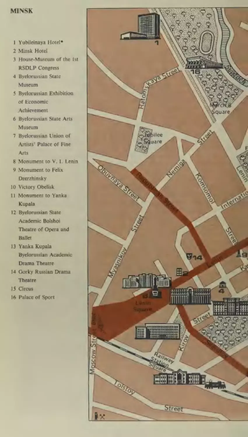
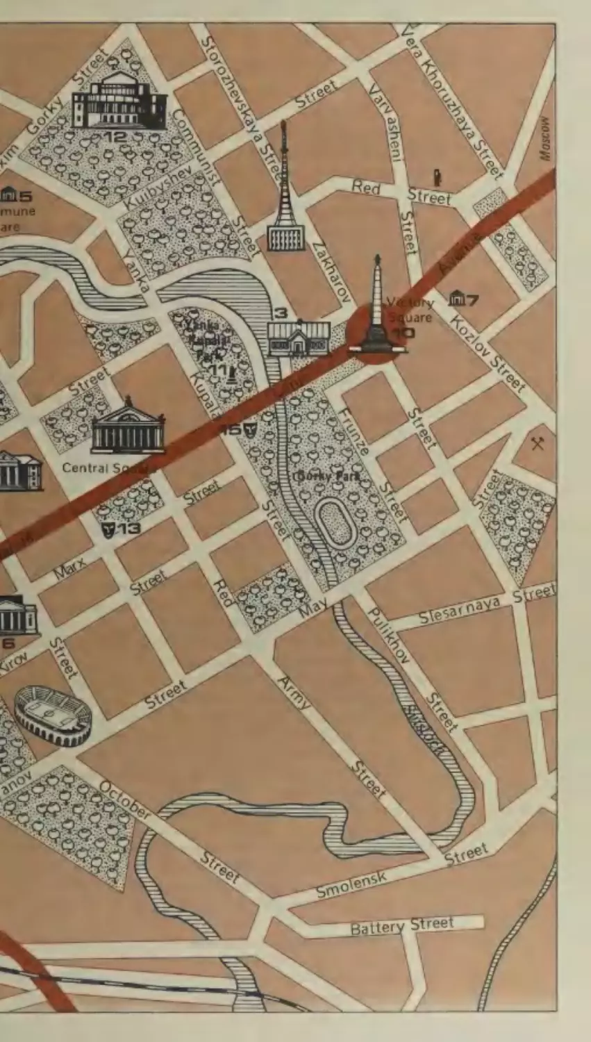
/
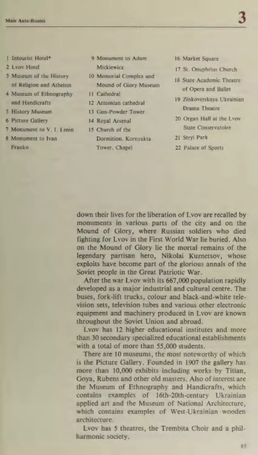


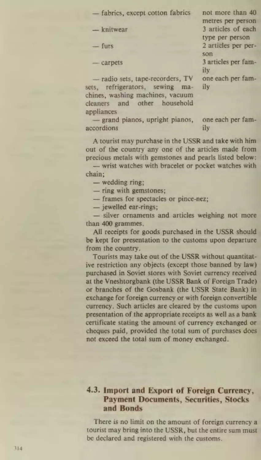

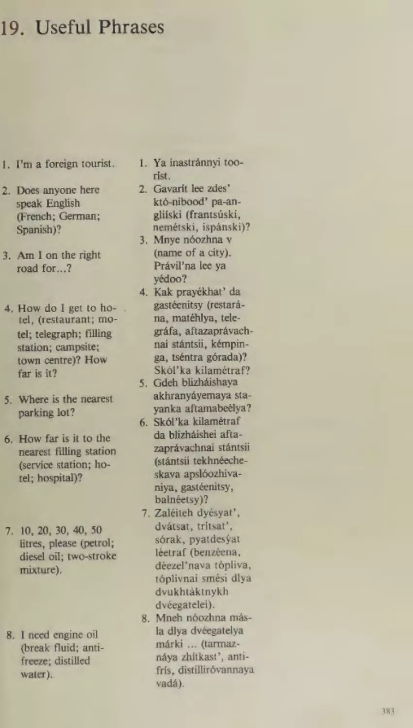
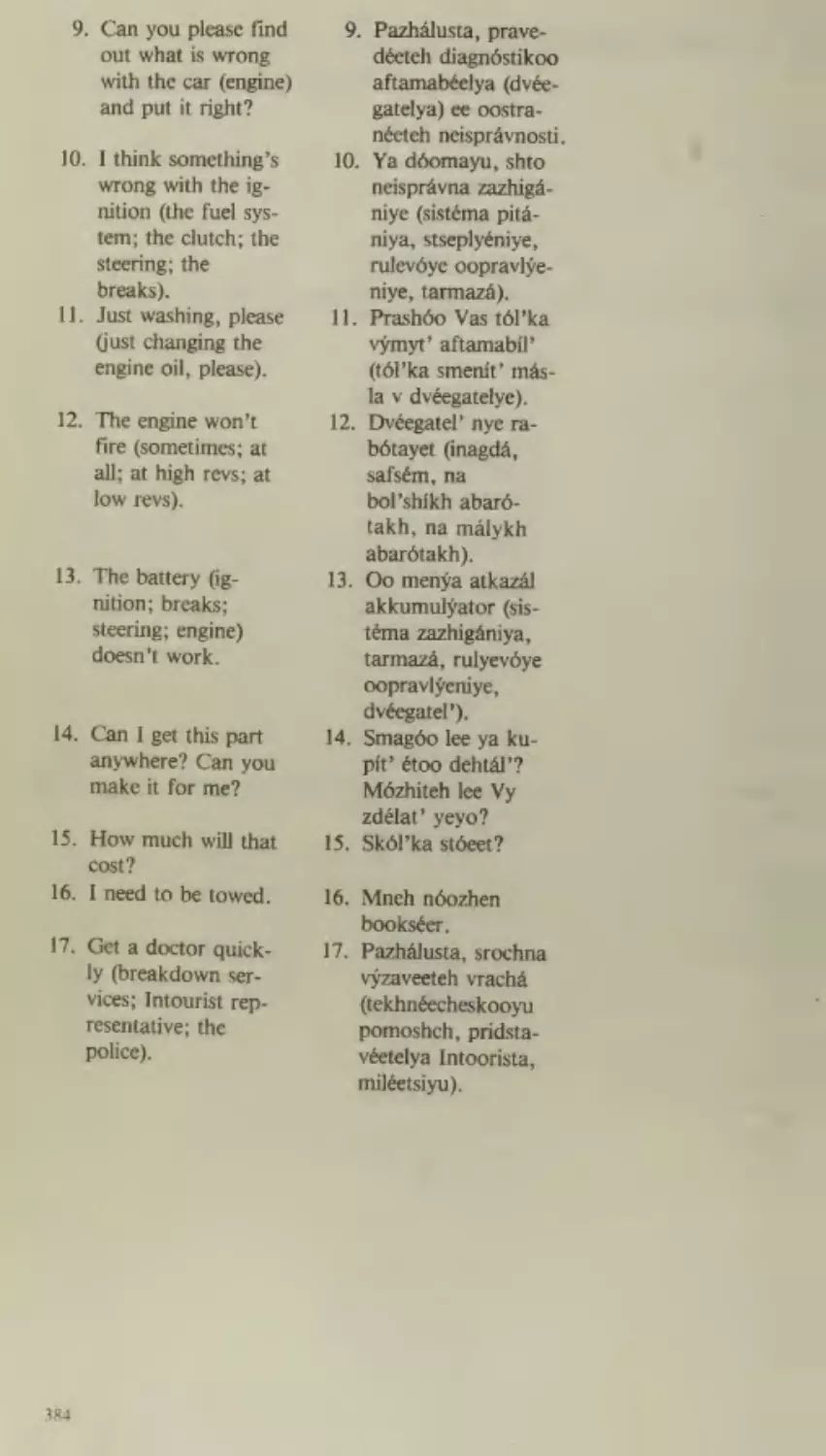


Text
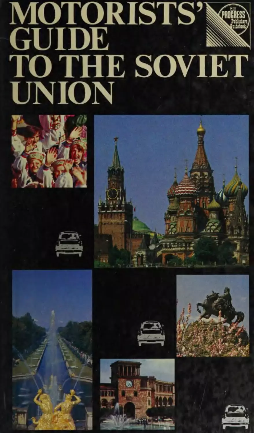
MOTORISTS’
GUIDE
8
at}
ROGRESS
Sty
CET
TO THE SOVIET
UNION
;
>.
; VILNIUS
5Le ;
© pers
Kosice
BUCHAREST
I
BULGARIA
5
LILLIAN MICH E sre]
3
LIBRARY
Novorossiish
:
8 wan sono
ST
ro
(GOLDWYN
wn
—~7
~~
wees
4
ae ae.
ee ae onl eA =
.8 ESTs
zi
212.469
x
213-€54-P77
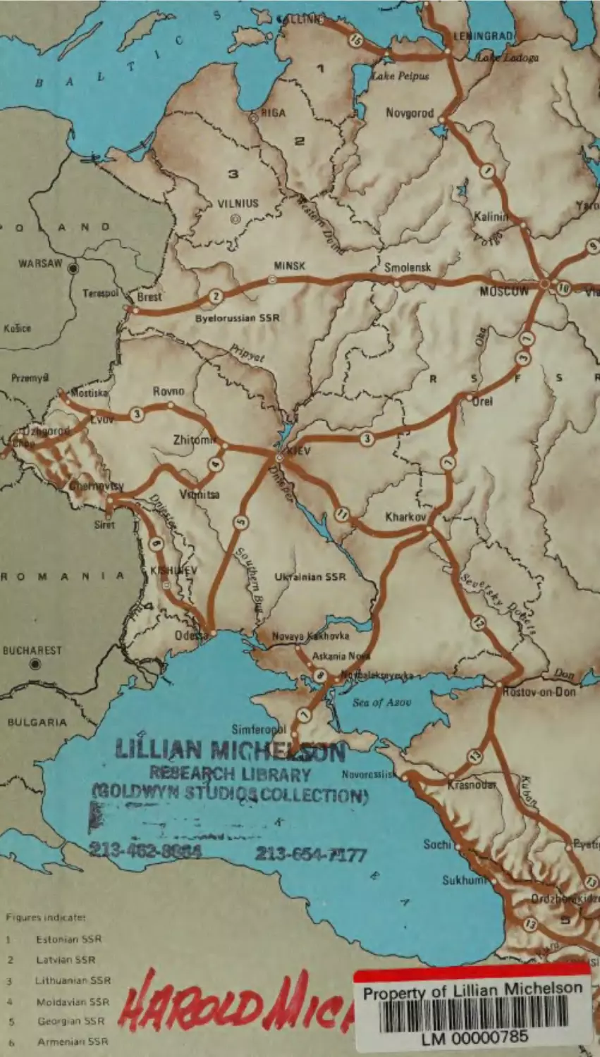
Figures indicate:
]
Estonian SSR
Latvian SSR
Lithuanian SSR
rwa
WY
FF
a
a
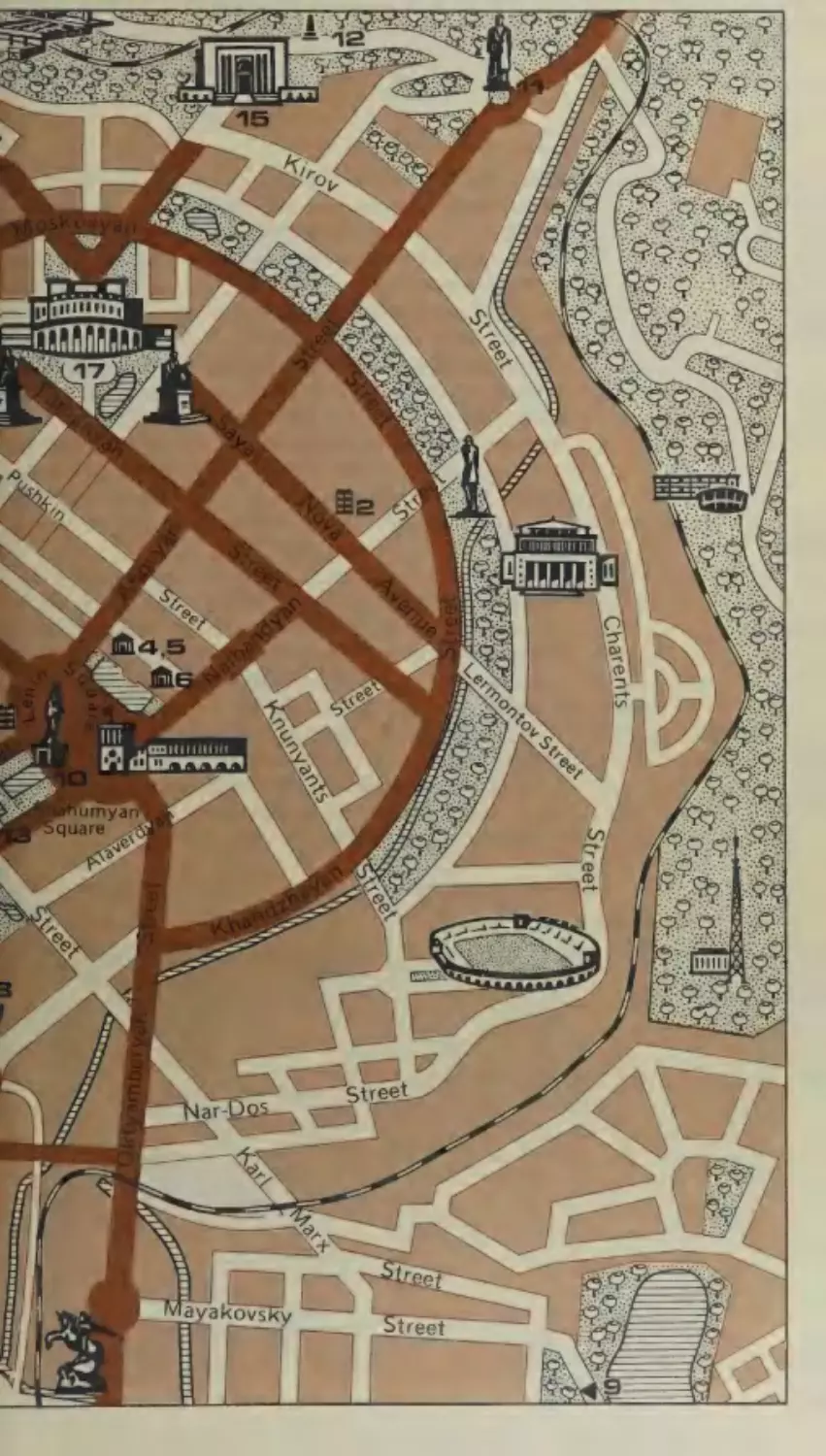
Armenian SSR
i
HAreetD Me,”ing
ry
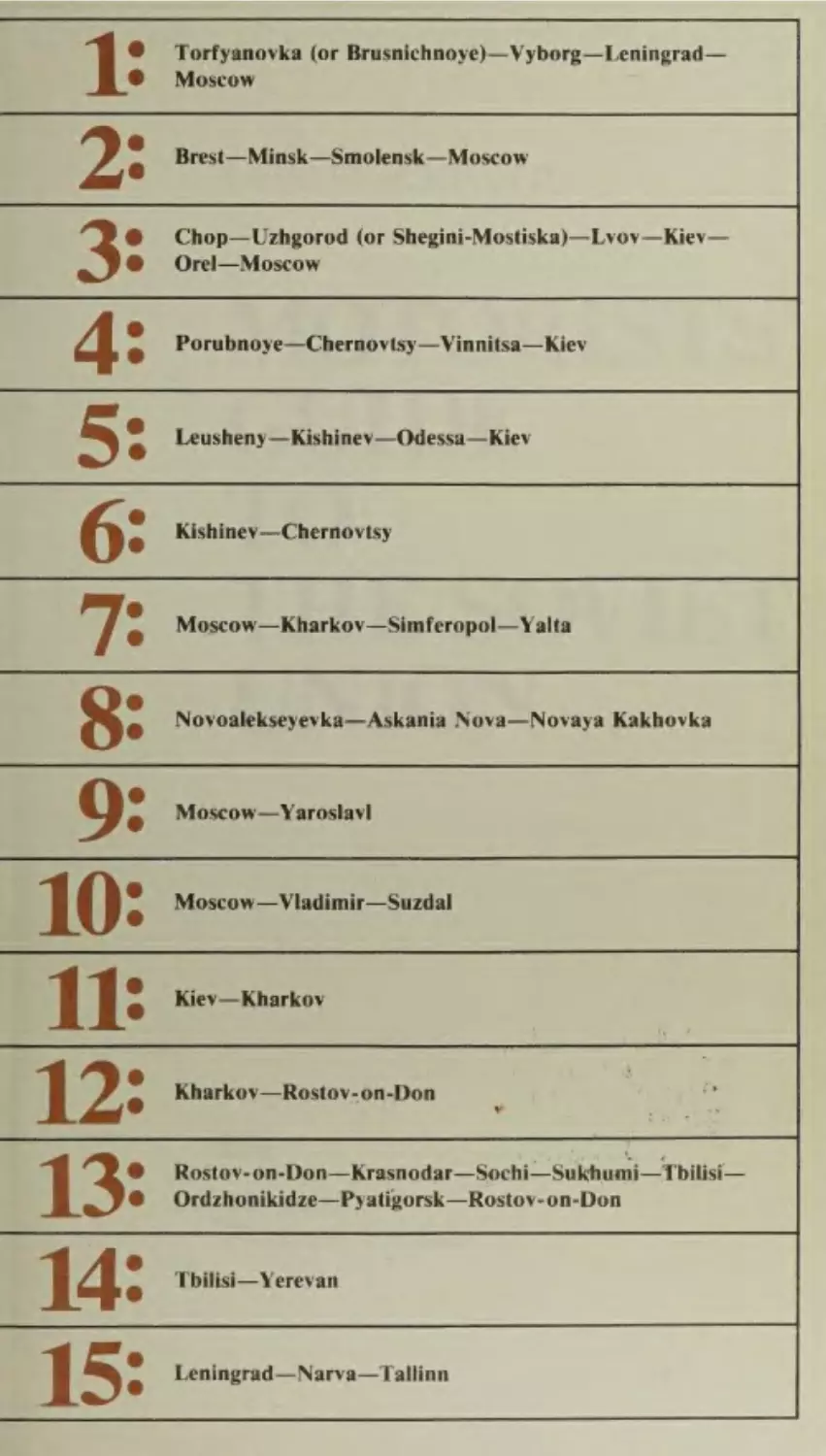
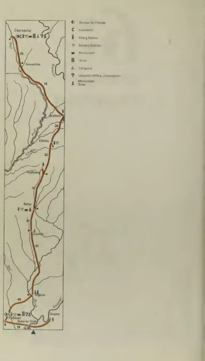
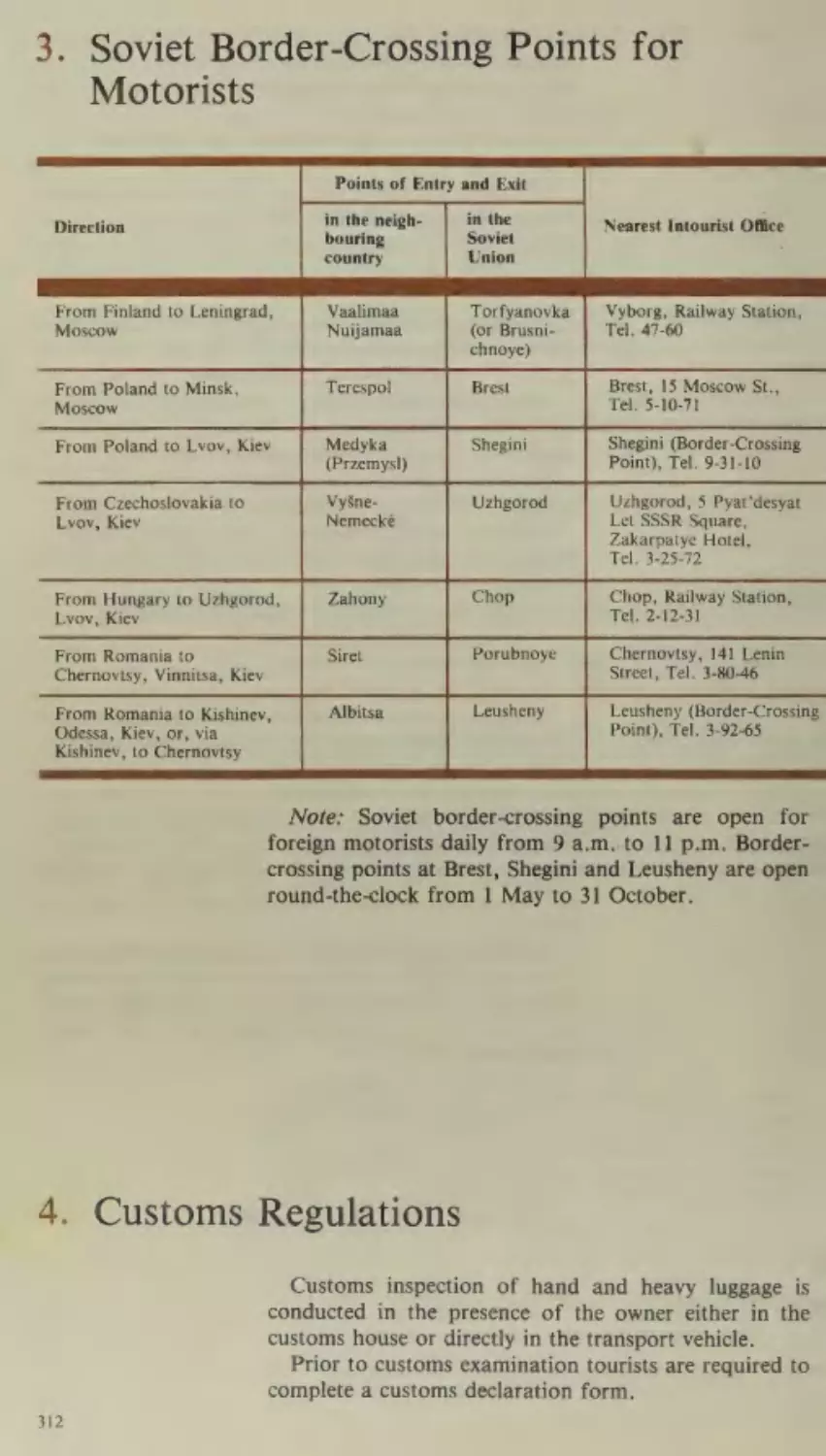
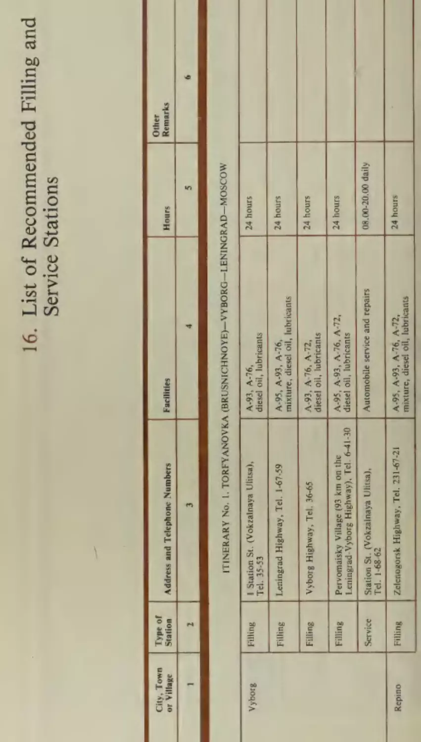
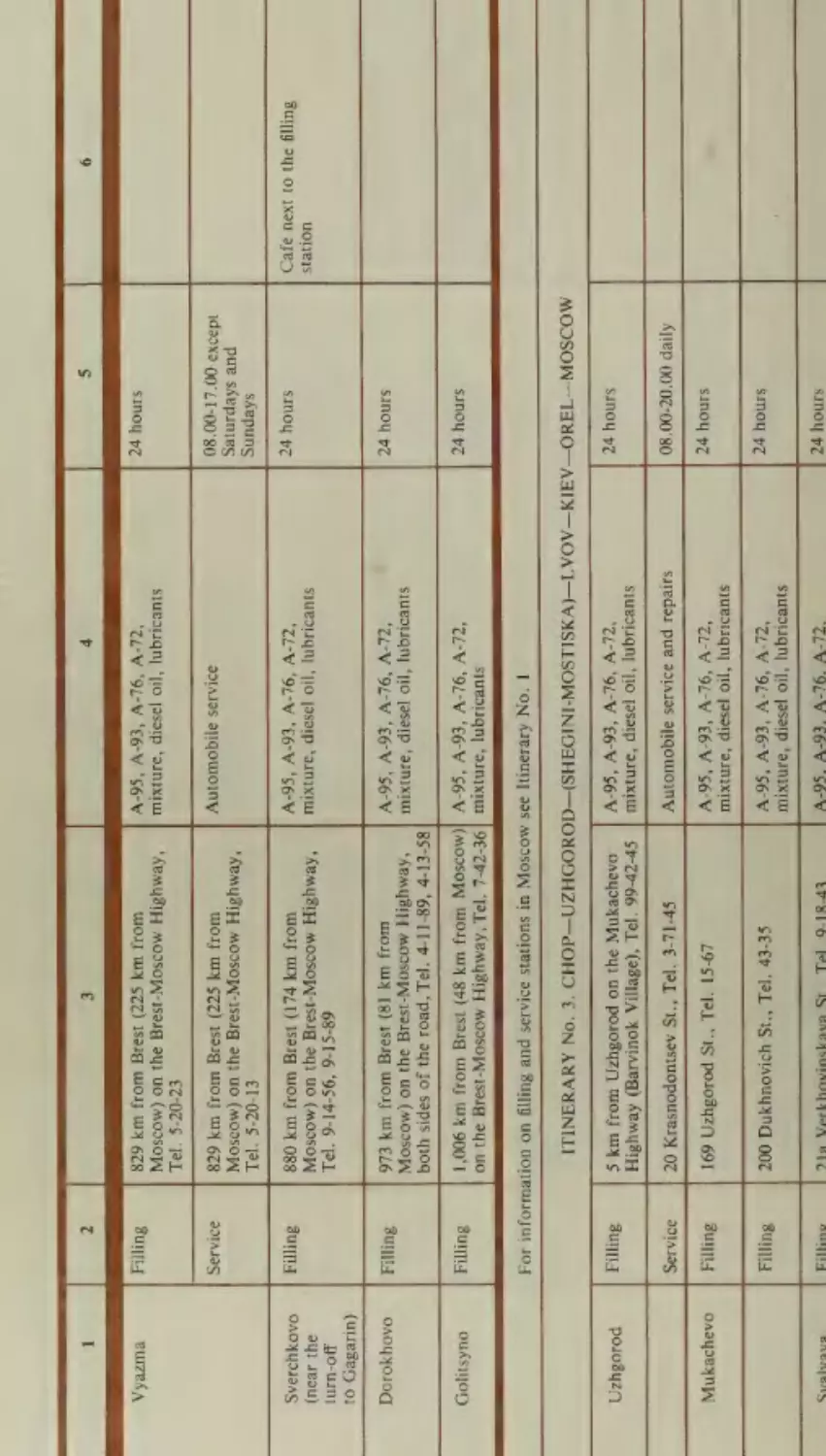
Torfyanovka (or Brusnichnoye)—Vyborg—Leningrad—
Moscow
Brest—Minsk—Smolensk—Moscow
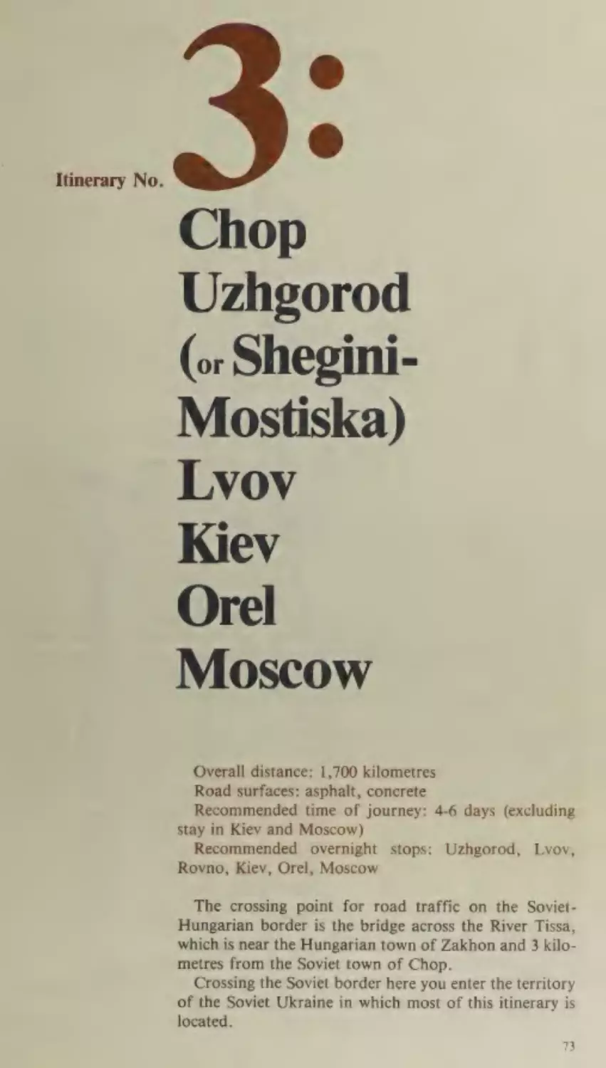
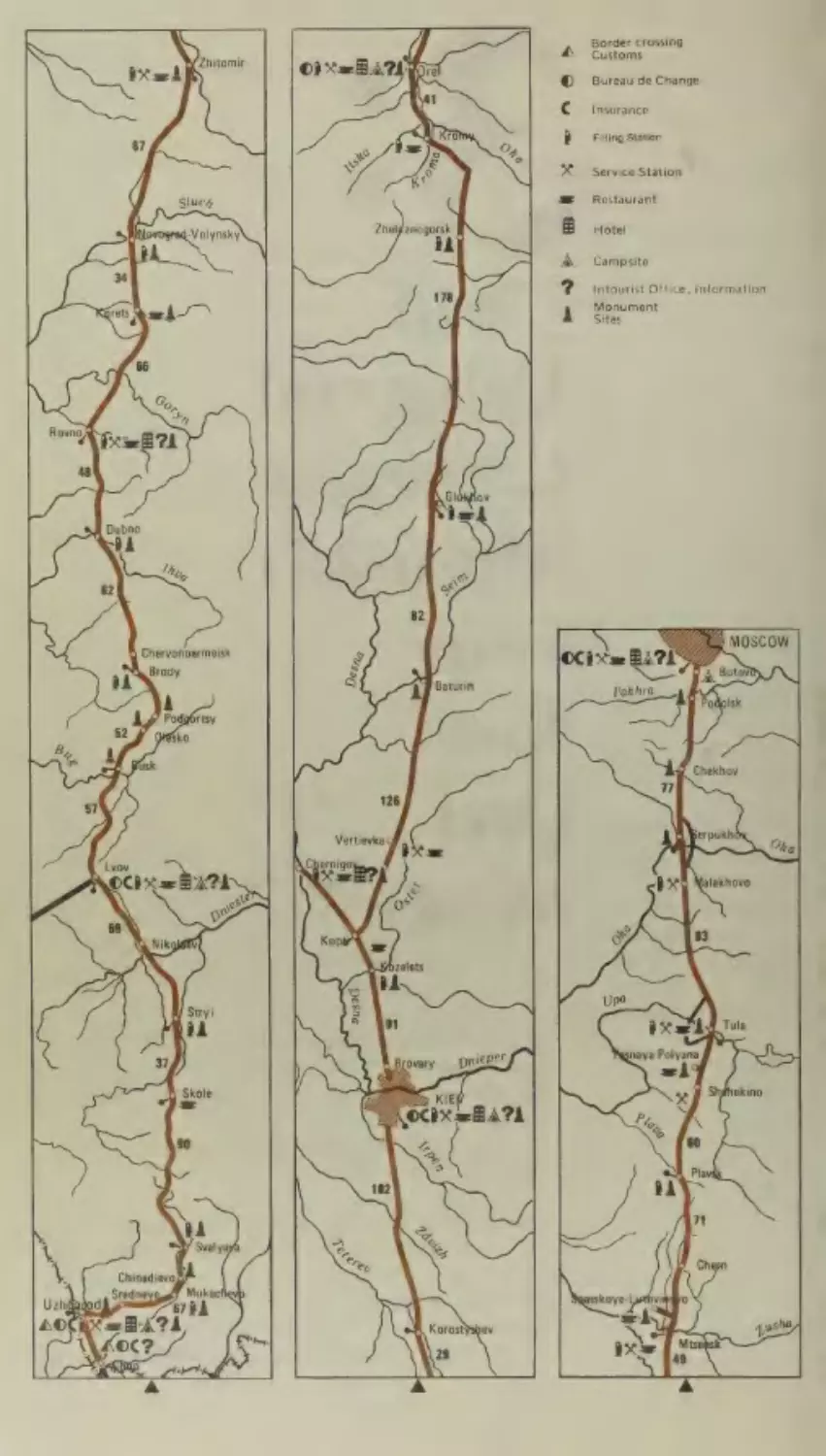
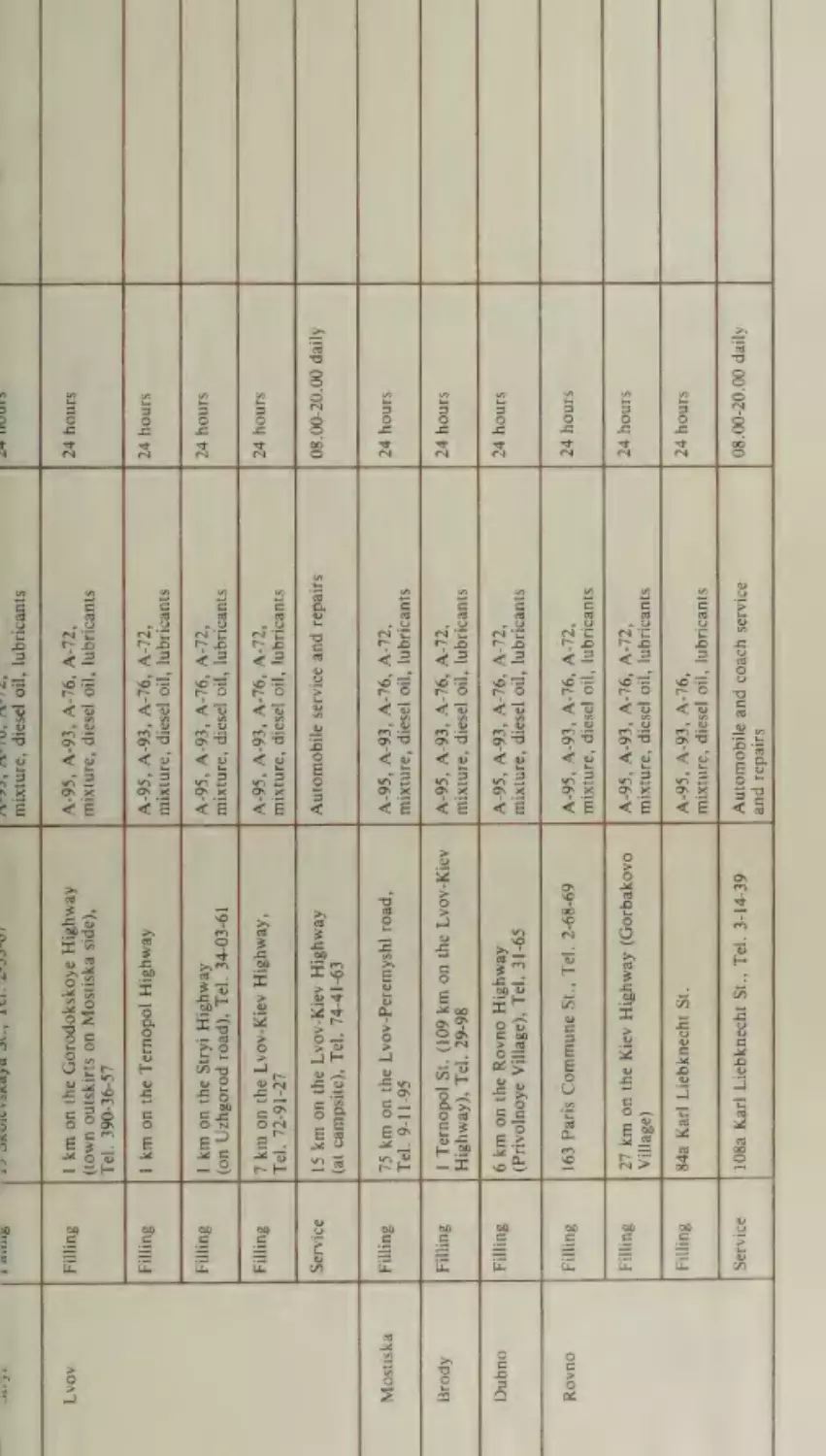
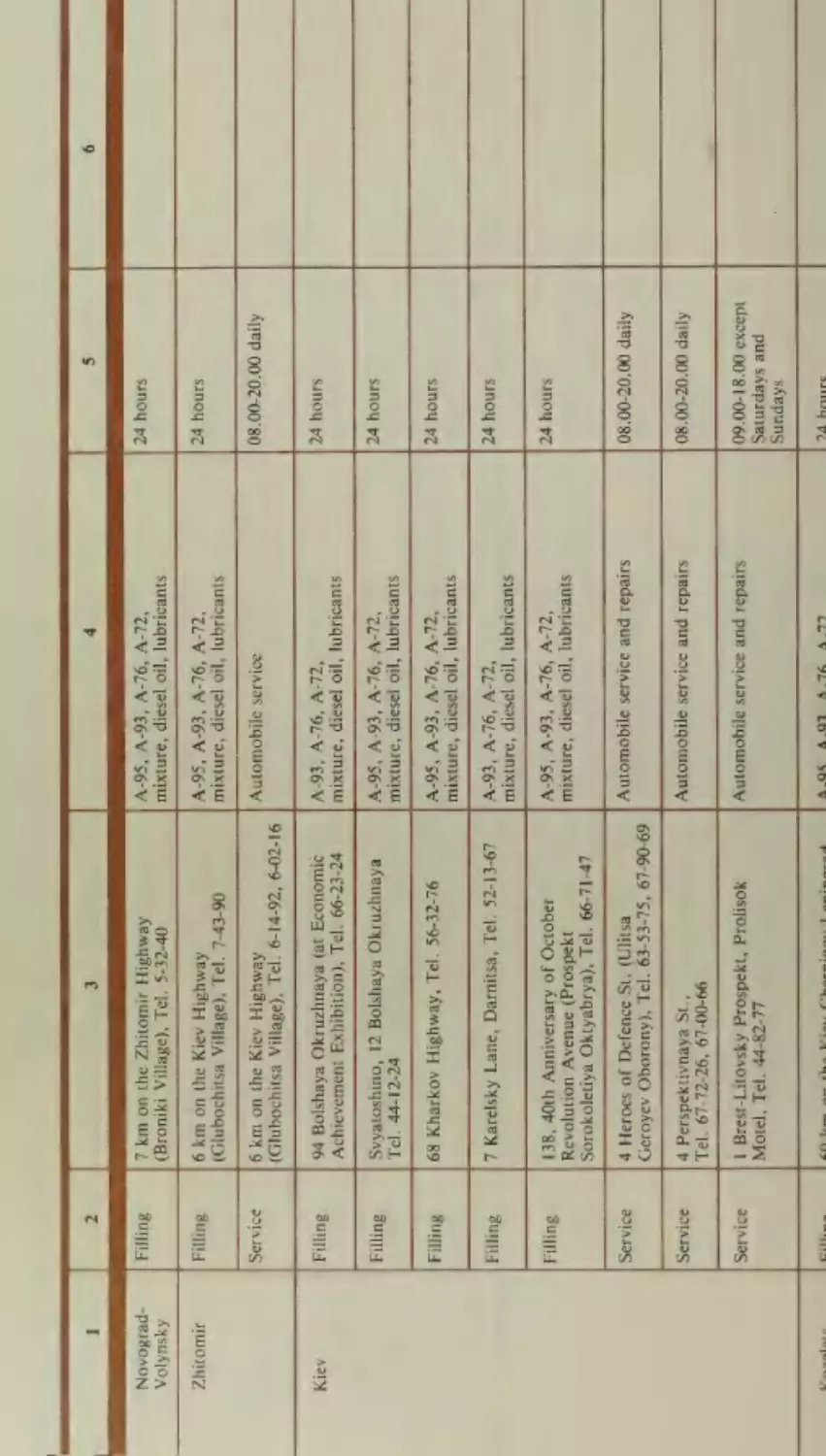
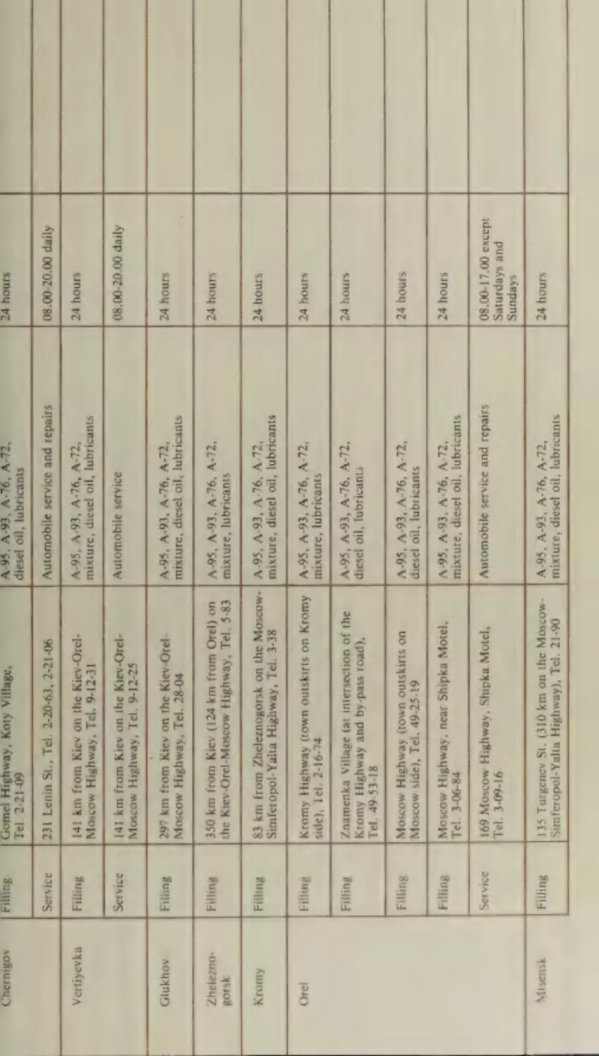
Chop—Uzhgorod
Orel—Moscow
(or Shegini-Mostiska)—Lvov—Kiev—
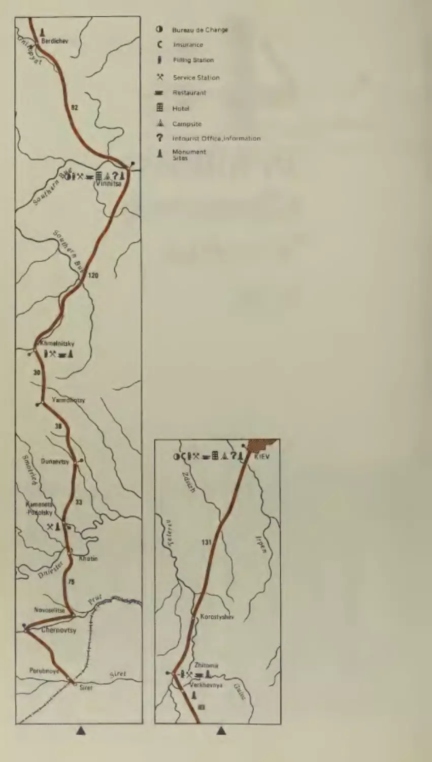
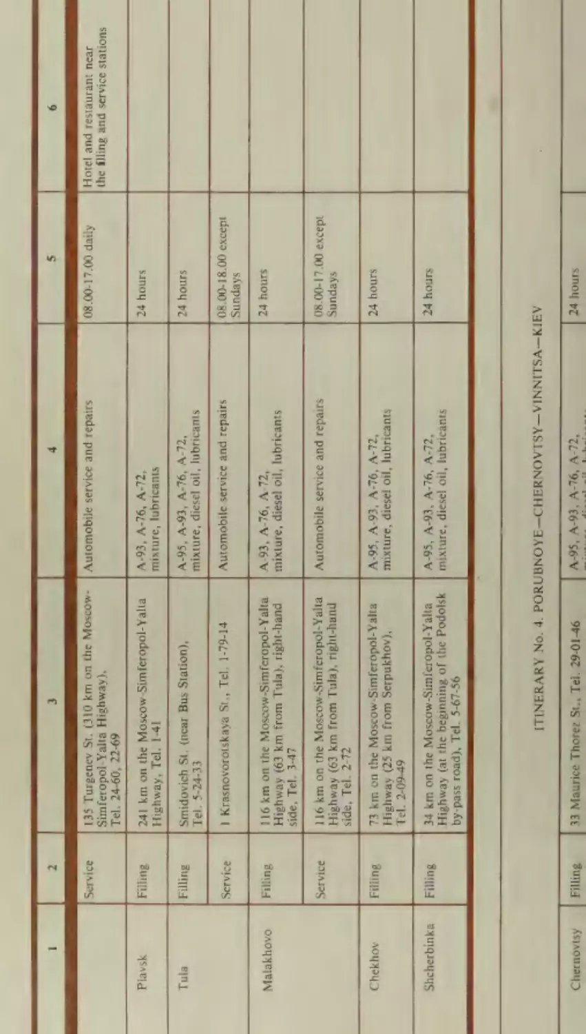
Porubnoye—Chernovtsy—Vinnitsa—Kiev
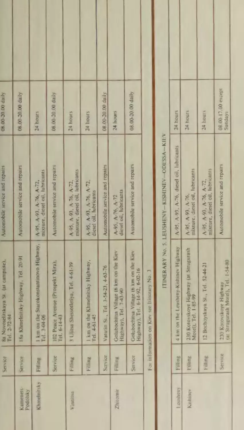
Leusheny—Kishinev—Odessa—Kiev
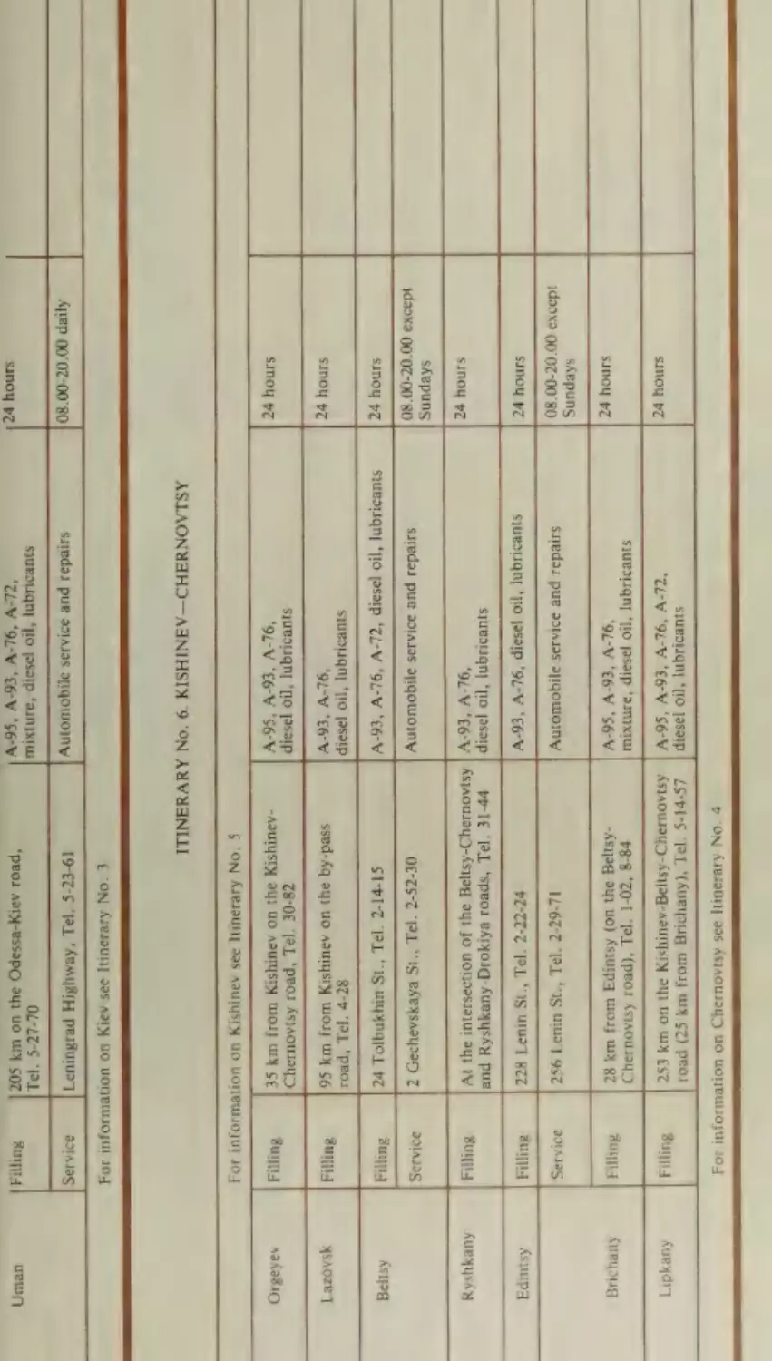
Kishinev—Chernovtsy
Moscow—Kharkov—Simferopol—
Yalta
Novoalekseyevka—Askania Nova—Novaya
Kakhovka
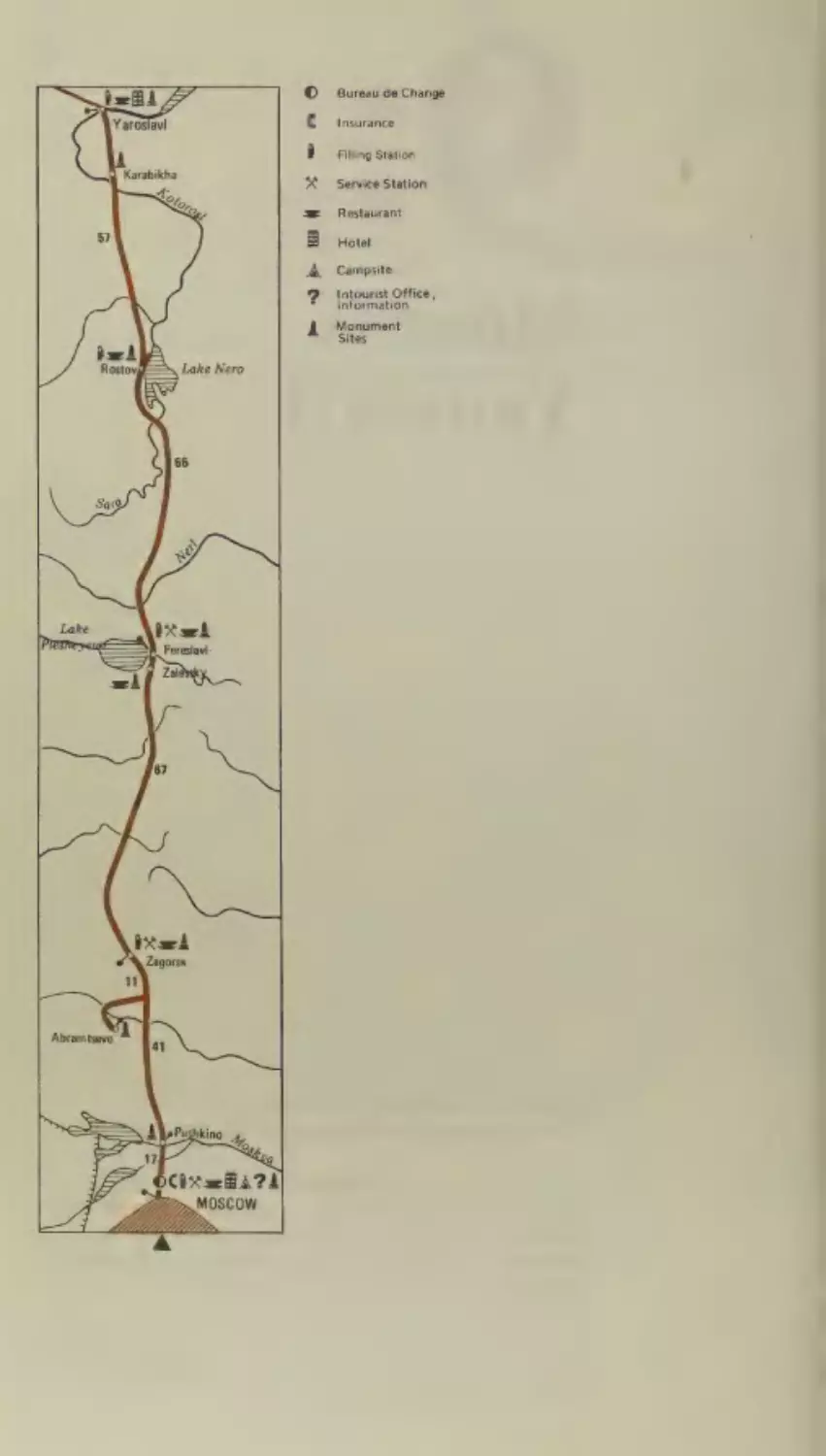
Moscow— Yaroslavl
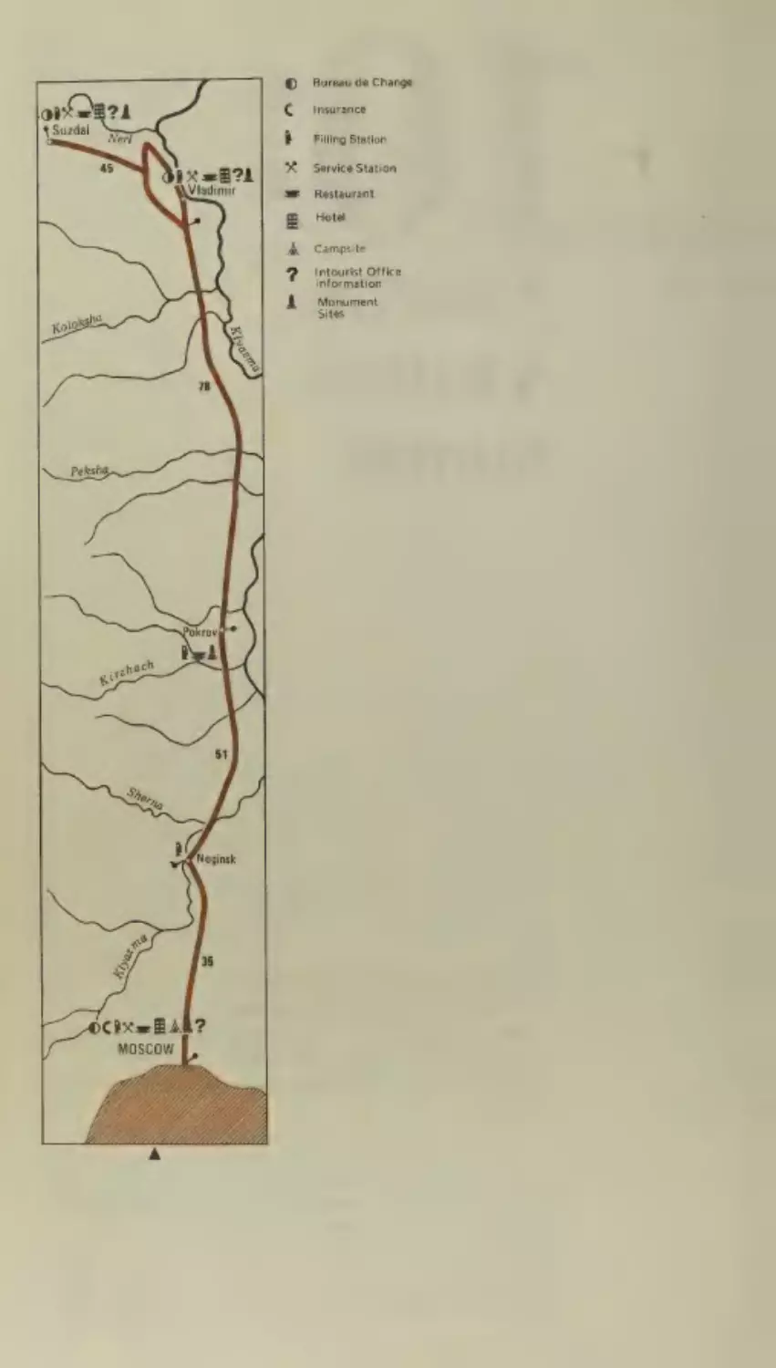
Moscow— Vladimir—Suzdal
loo)
1S]
lbp
|e
aloy|un)
Kiev—Kharkov
Kharkov—Rostov- on-Don
v
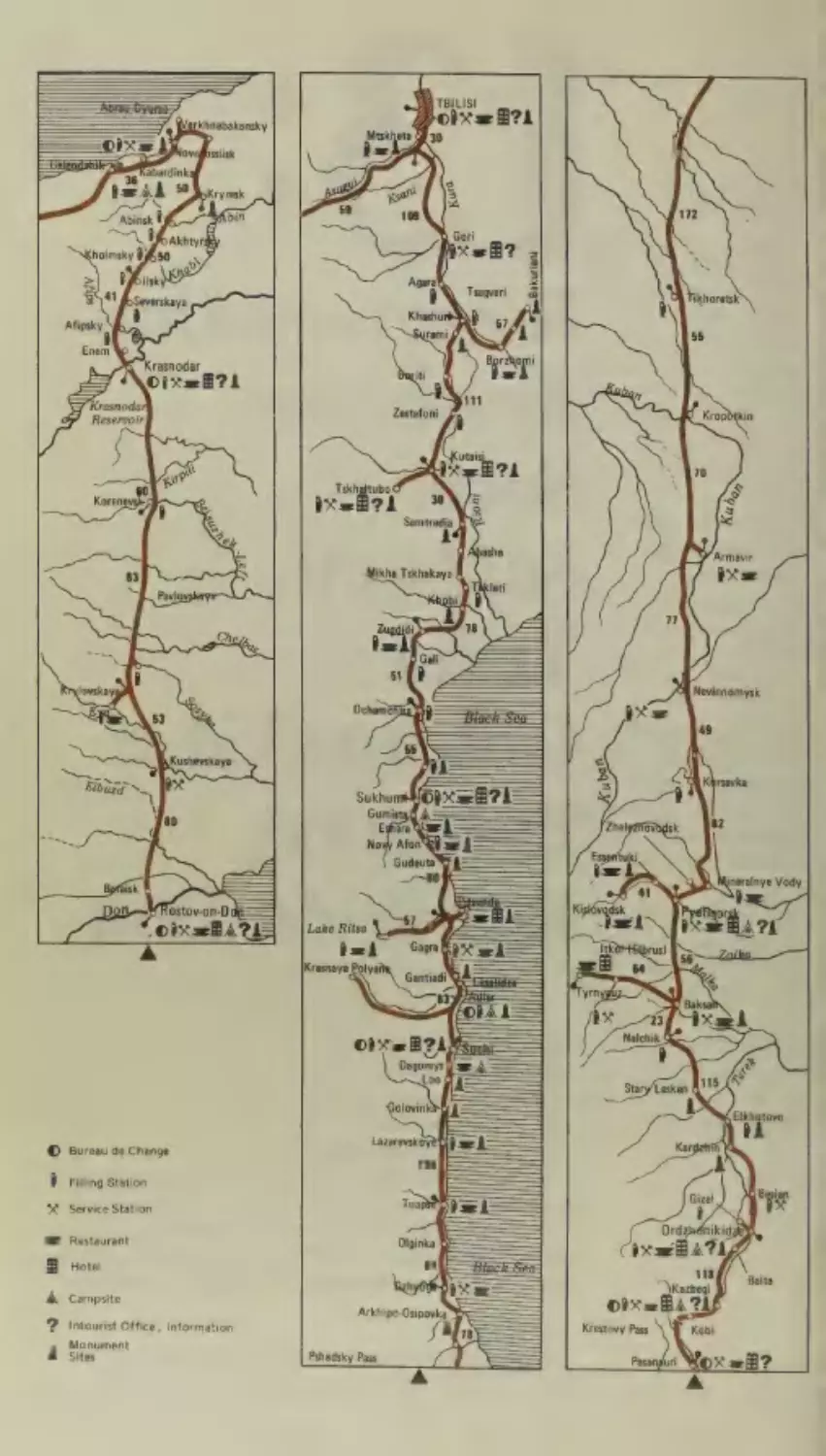
Rostov-on-Don—Krasnodar—Sochi—Sukhumi—Tbilisi—
Ordzhonikidze—Pyatigorsk—Rostov-on-Don
Tbilisi— Yerevan
Leningrad—Narva—Tallinn
ive
.
en.
aA
y
@
7
eV ede
sealed
re
aa.
er
Leonid Zadvorny
MOTORISTS’
GUIDE
TO
THE SOVIET
UNION
JI. 3anBopHEmi
HA ABTOMOBMWJIE TIO COBETCKOMY
COIO3Y
TlyTesoquTenb-cnpaBouHHK
Ha aveauiicKom a3vike
Translated from the Russian by Barry Jones
Editor of the Russian text V. Ostroumov
Editor of the English text A. Timofeyev
Designed by A. Tomchinskaya
Art editor L. Shkanov
Maps by V. Sokolov
© Vi3aatensctso ,,IIporpecc‘‘,
1980
English translation © Progress Publishers 1980
Updated to January 1, 1978
20904-7
3 014(01)-80
6e3 o6baBN.
1905040100
CONTENTS
Introduction
9
Partl. MAIN AUTO-ROUTES
11
The Soviet Union
Itinerary No.
}
13
Torfyanovka (or Brusnichnoye)—
Vyborg—Leningrad—Moscow
17
The Russian Federative
Republic
Vyborg
Leningrad
Novgorod
Kalinin
Moscow
Itinerary No.
Dd
3
42
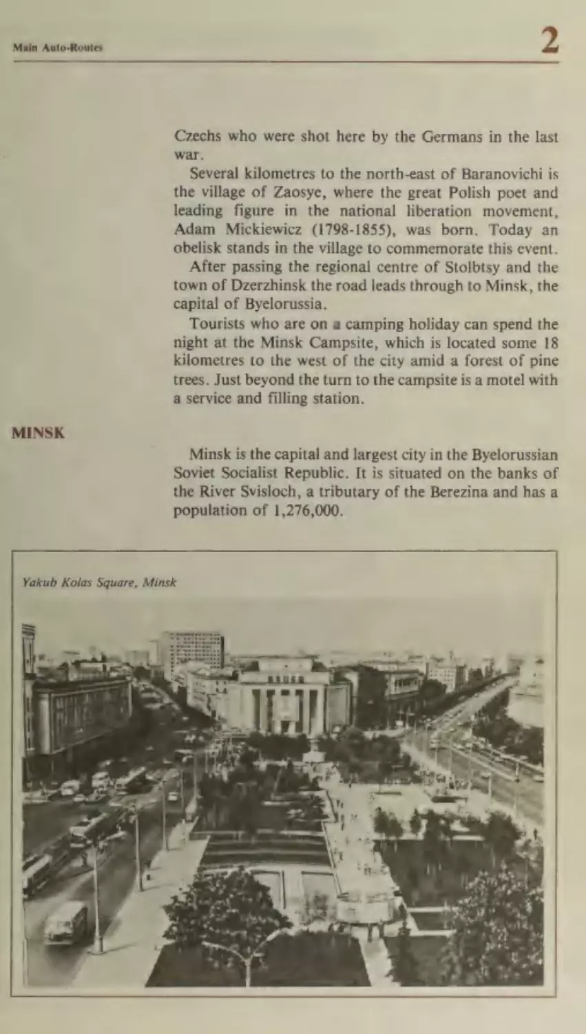
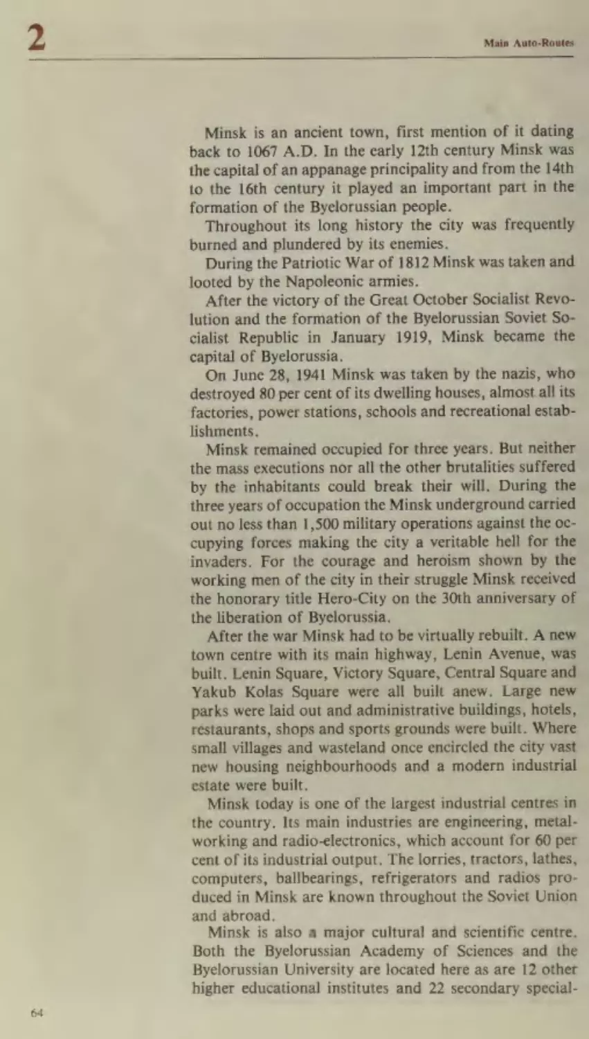
Brest—Minsk—Smolensk—Moscow
Byelorussia
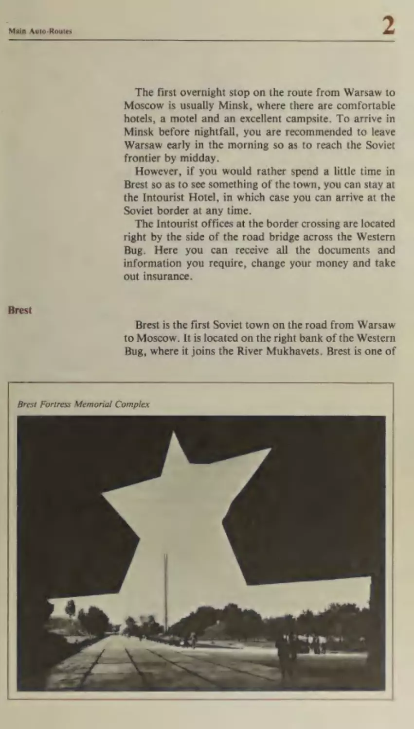
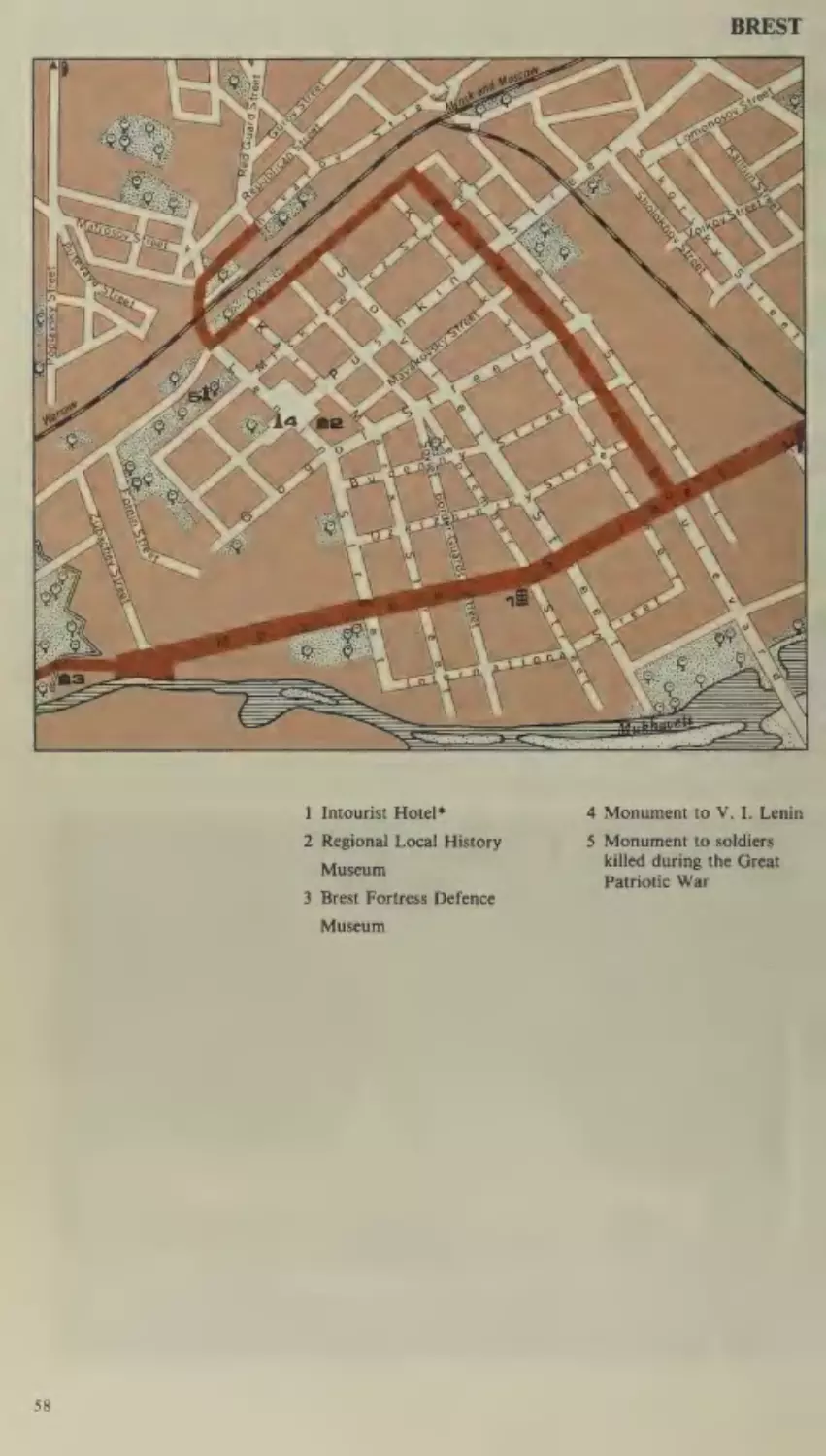
Brest
Minsk
Smolensk
Itinerary No.
19
ee
23
34
39
Chop—Uzhgorod (or Shegini-Mostiska)—
73
Lvov—Kiev—Orel—Moscow
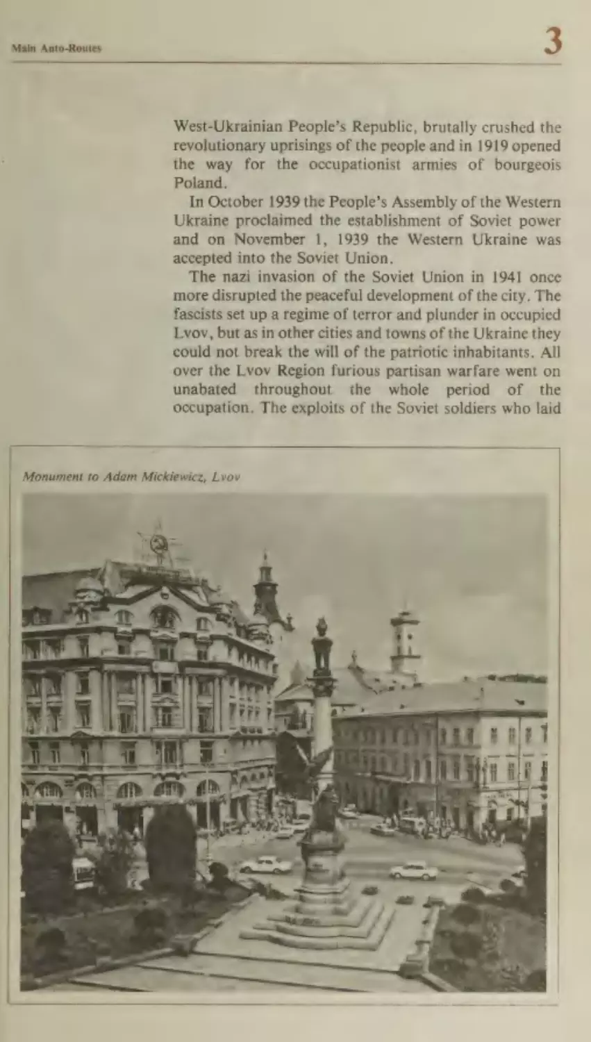
The Ukraine
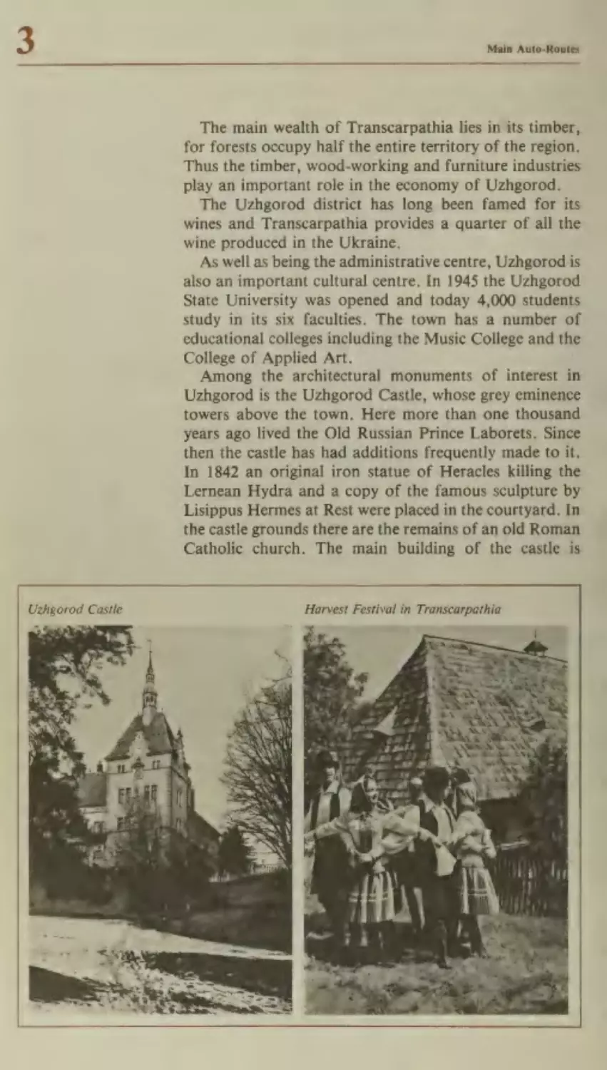
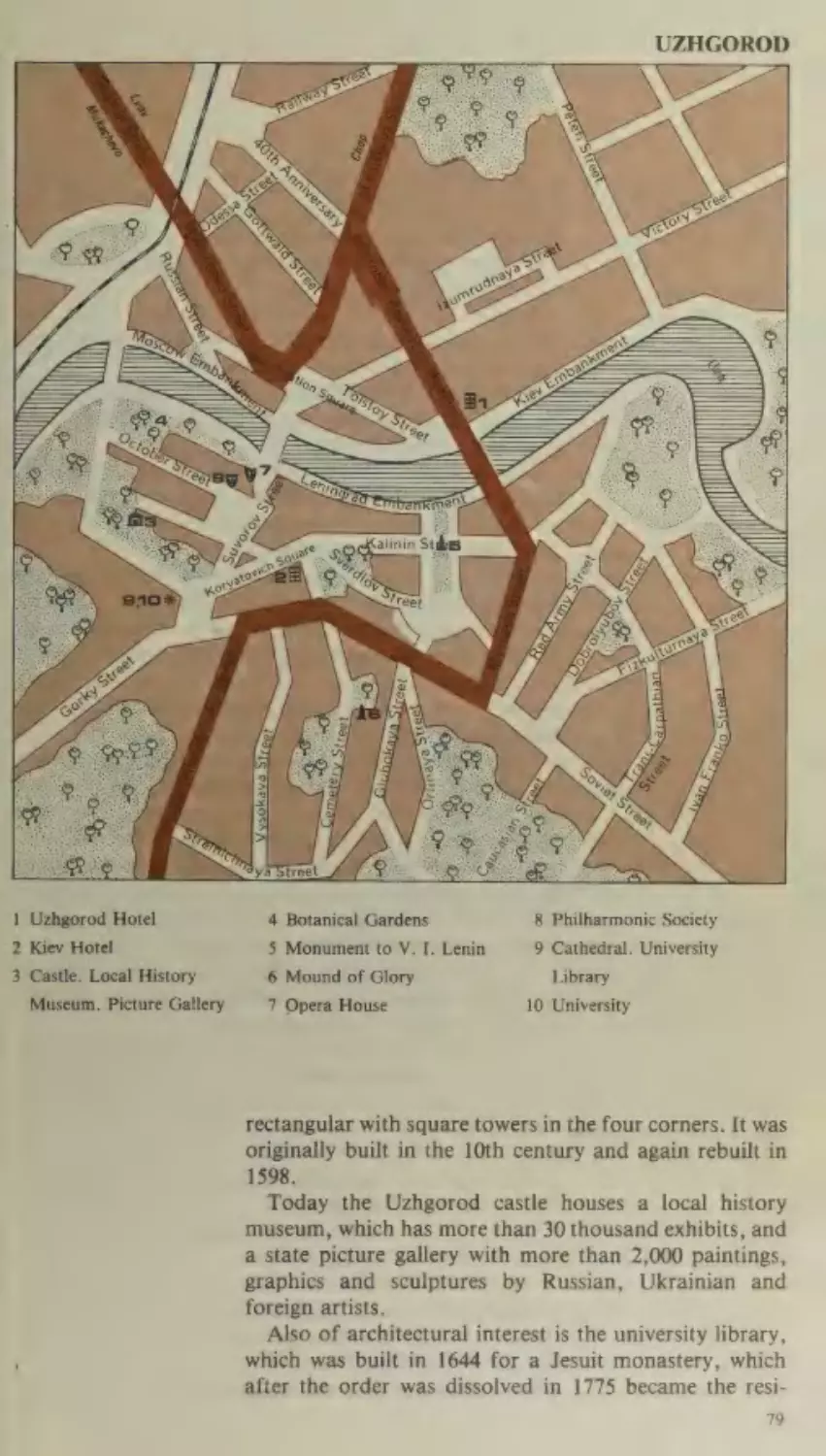
Uzhgorod
Mukachevo
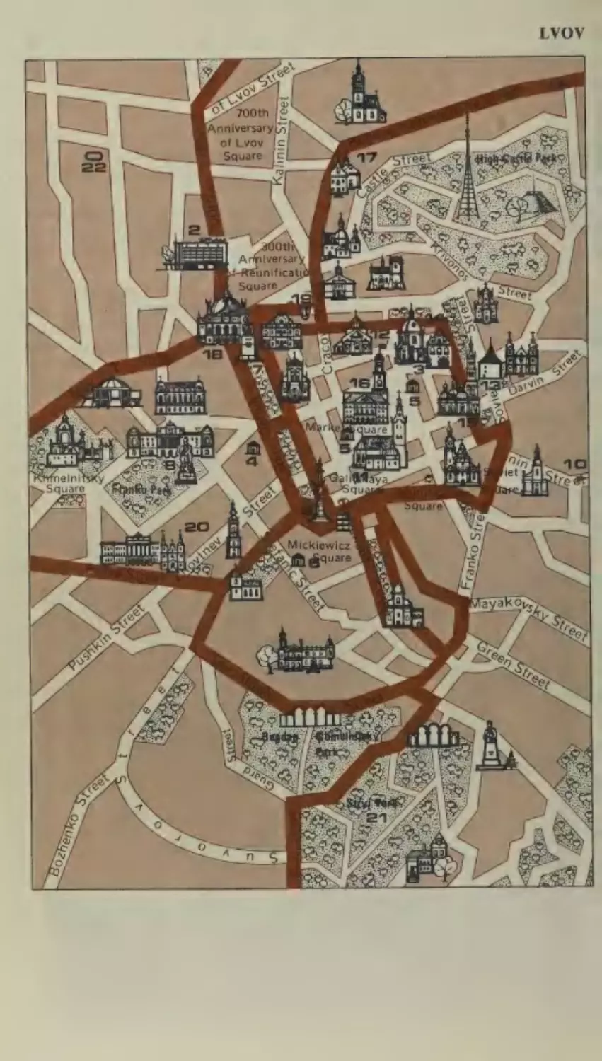
Lvov
Rovno
Zhitomir
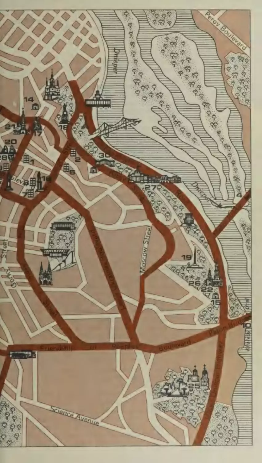
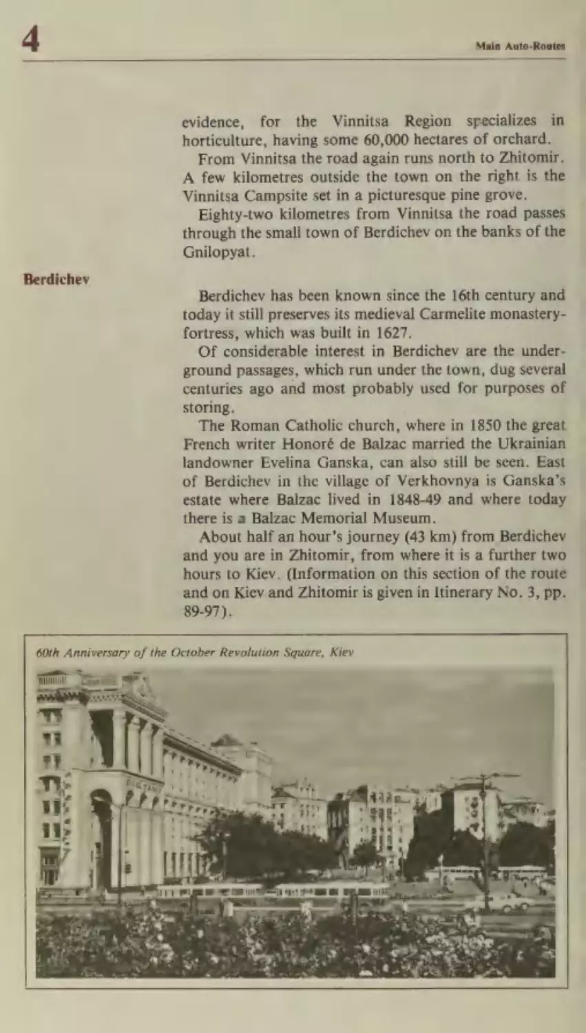
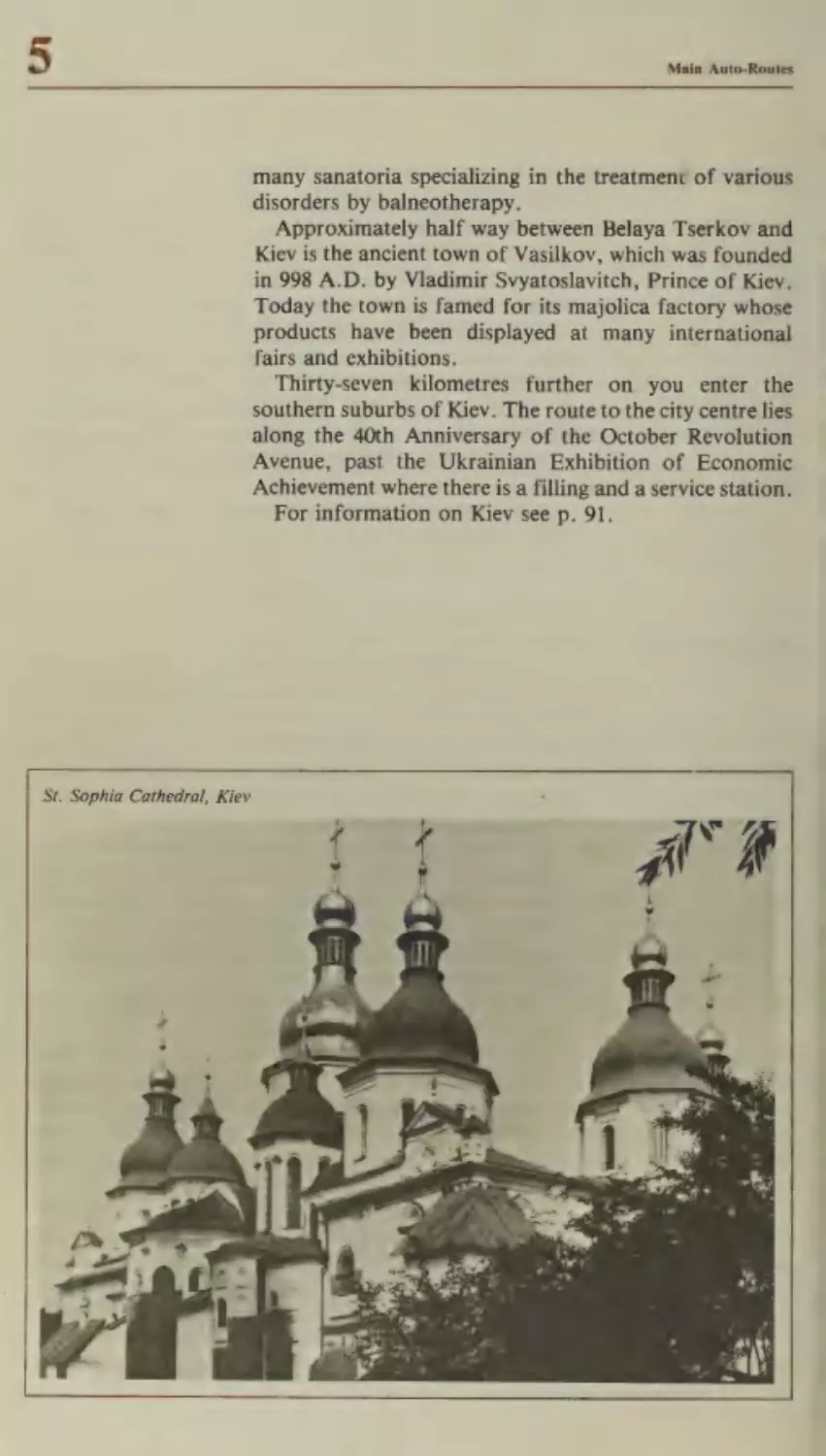
Kiev
Chernigov
Orel
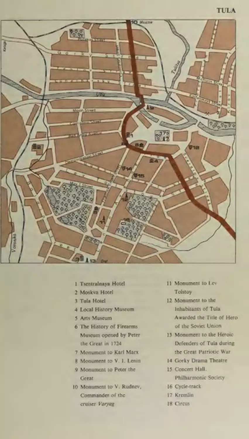
Tula
Podolsk
Itinerary No.
f
53
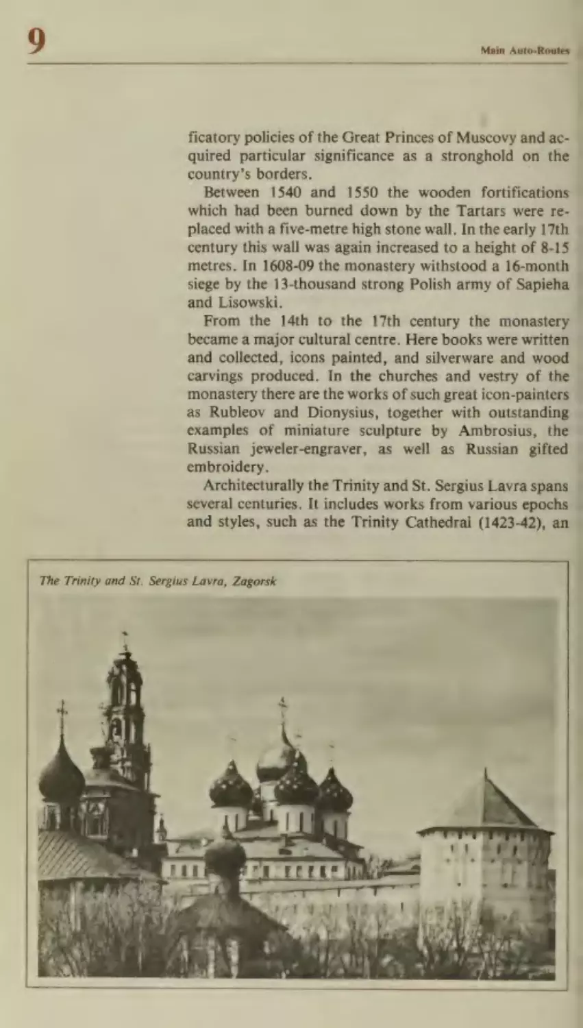
55
2
61
67
75
77
80
82
87
89
91
97
99
102
105
Porubnoye—Chernovtsy —Vinnitsa—Kiev
Chernovtsy
Kamenets-Podolsky
Khmelnitsky
Vinnitsa
Berdichev
109
112
ne
114
116
107
Itinerary No.
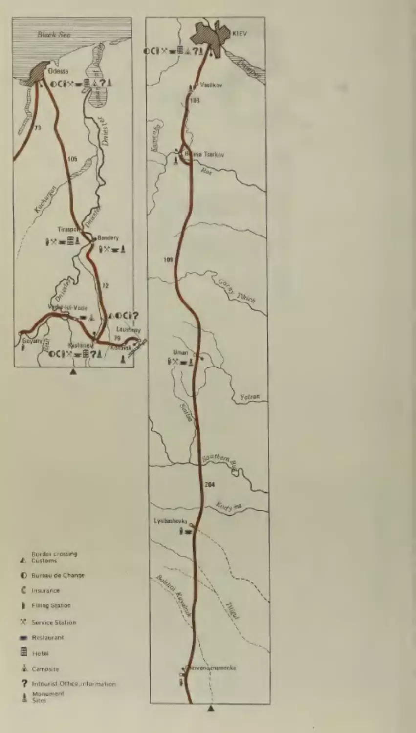
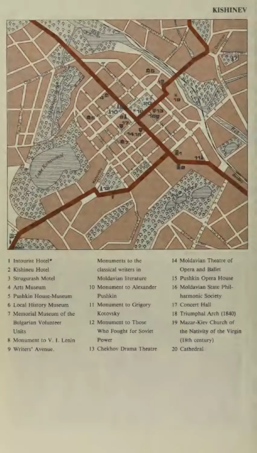
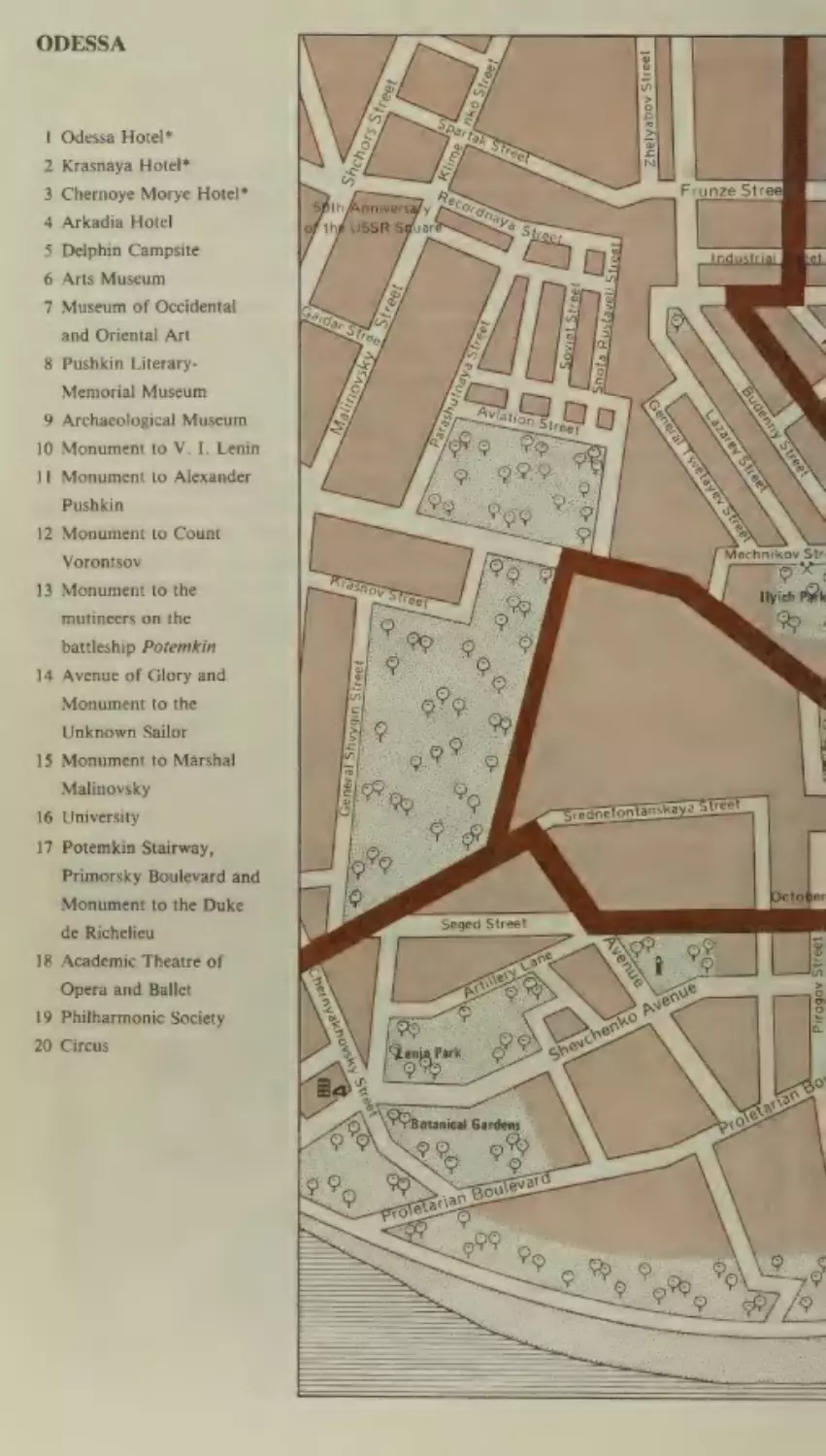
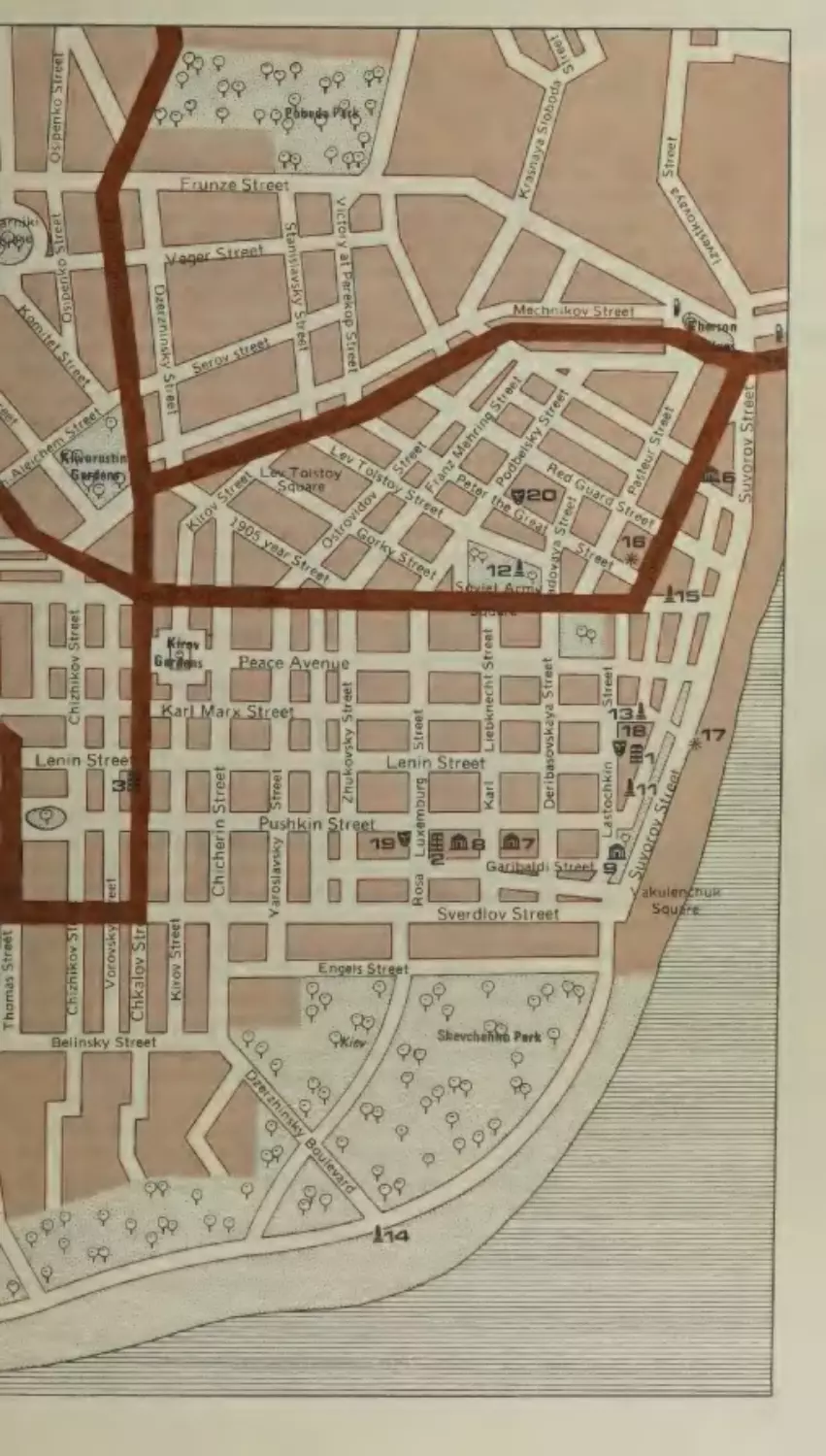
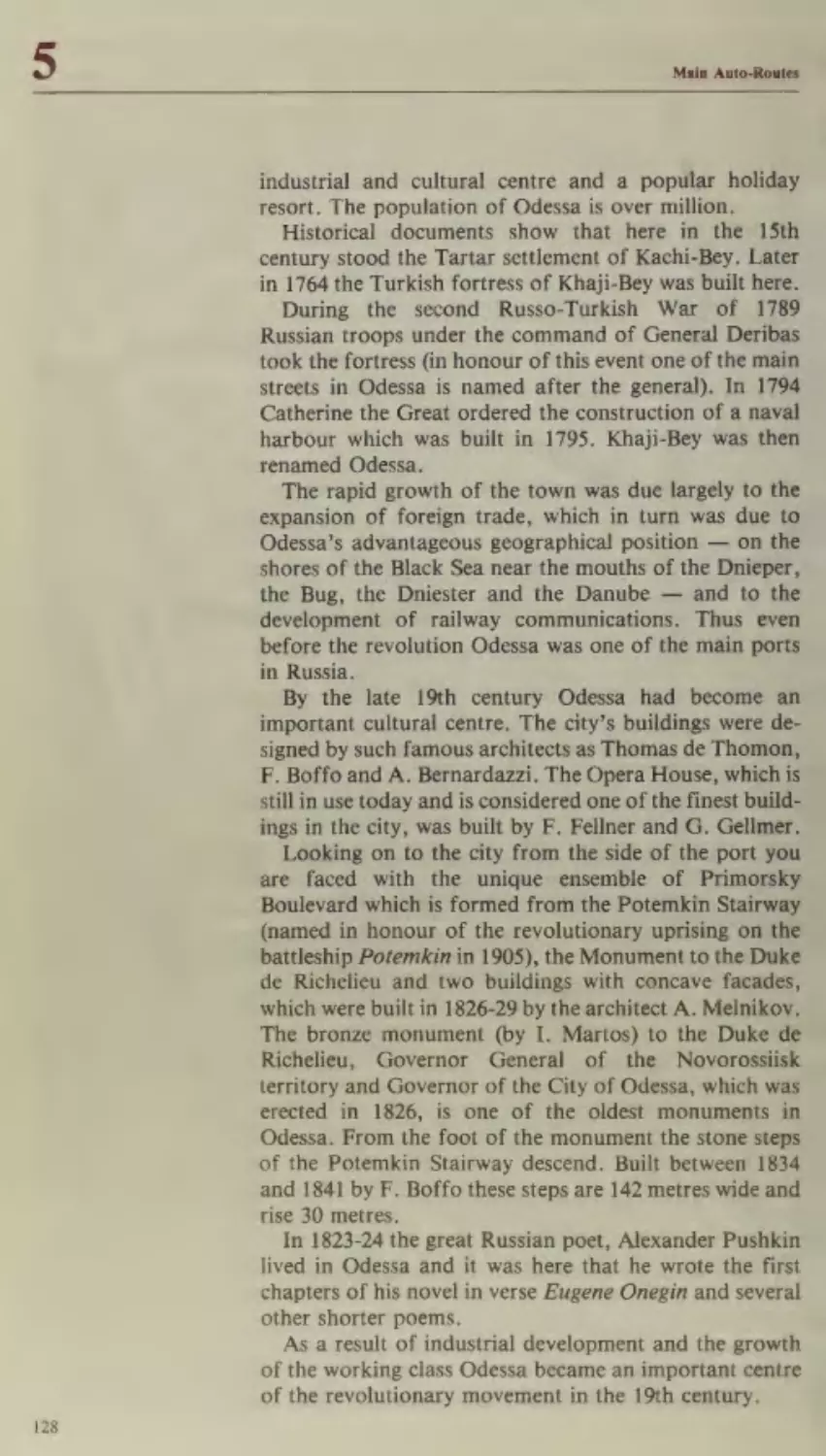
Leusheny—Kishinev—Odessa—Kiev
5
Moldavia
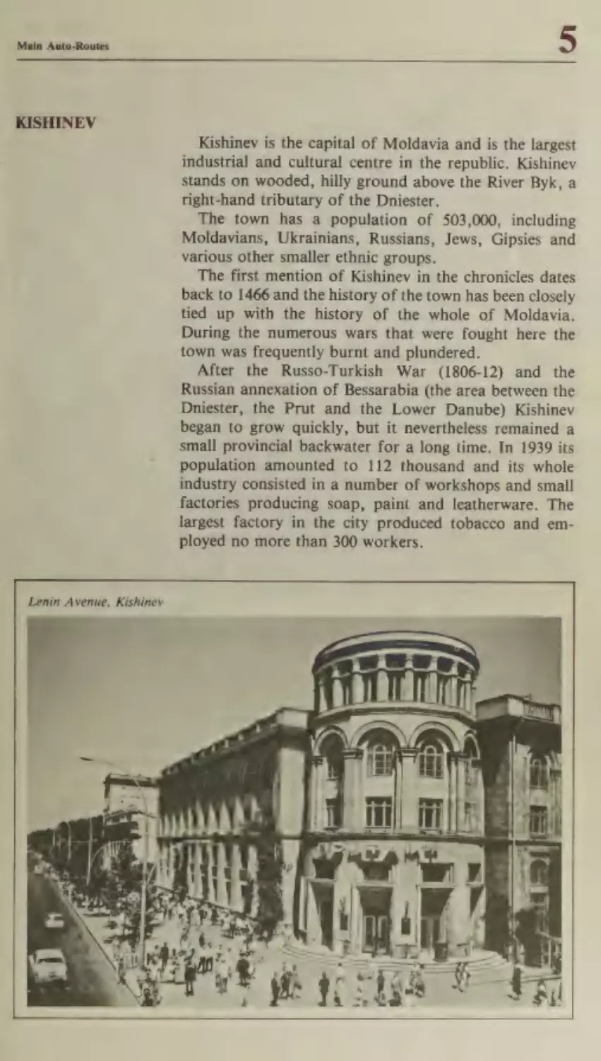
Kishinev
Bendery
Tiraspol
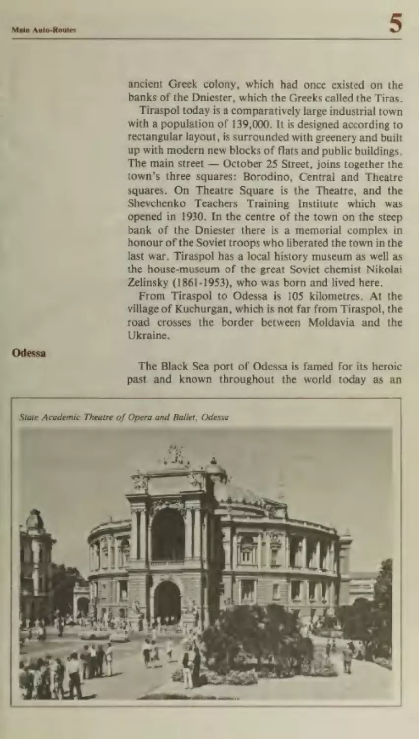
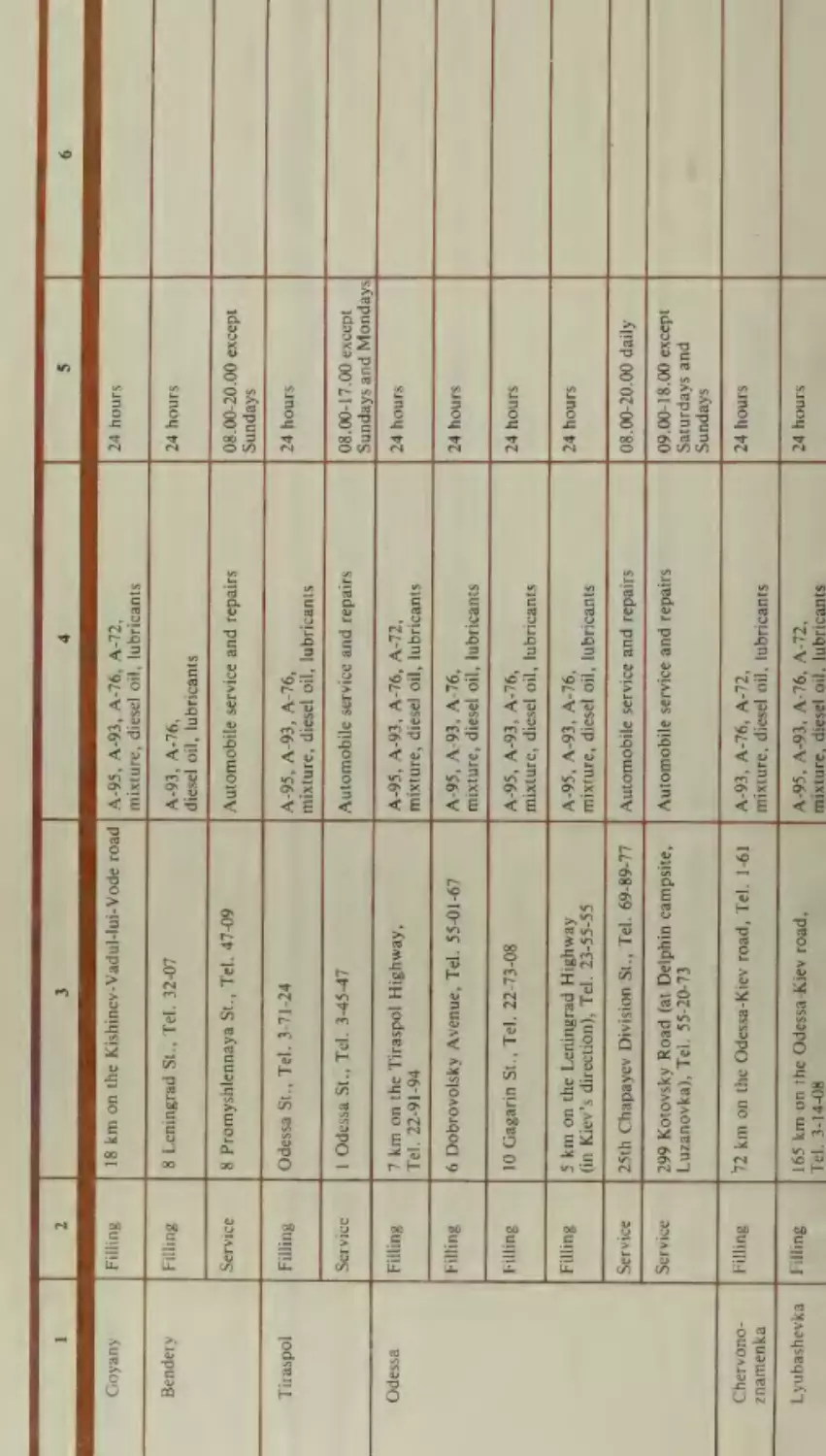
Odessa
Uman
Belaya Tserkov
Itinerary No.
5
Itinerary No.
Itinerary No.
®
®
$
Kursk
Belgorod
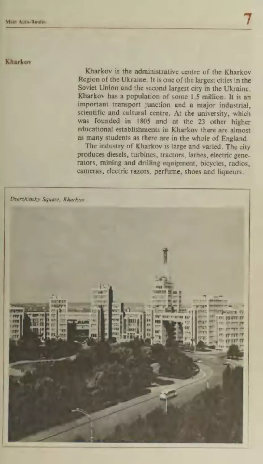
Kharkov
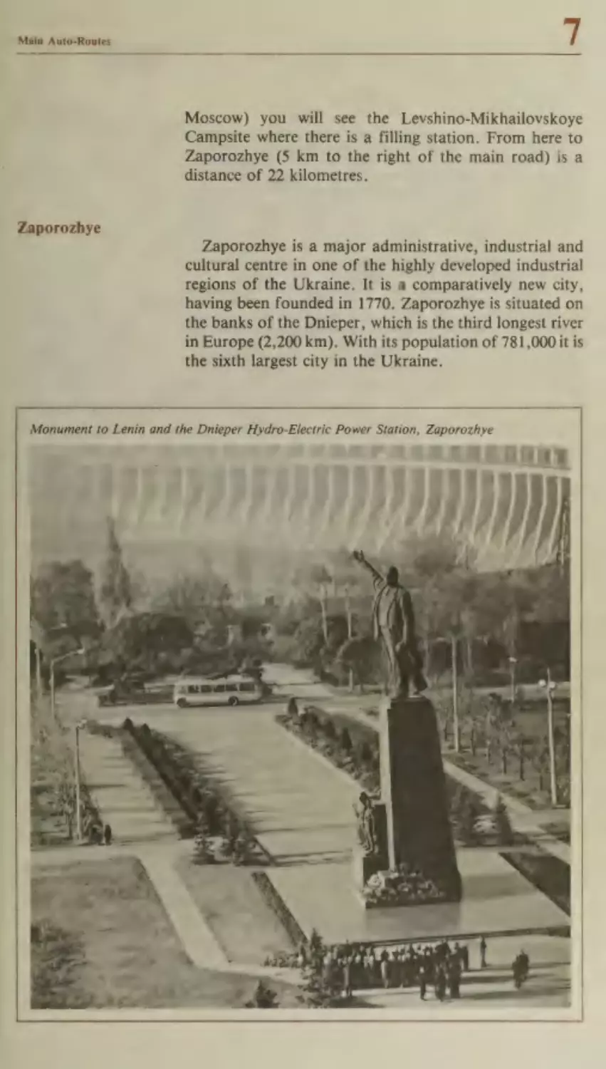
Zaporozhye
Melitopol
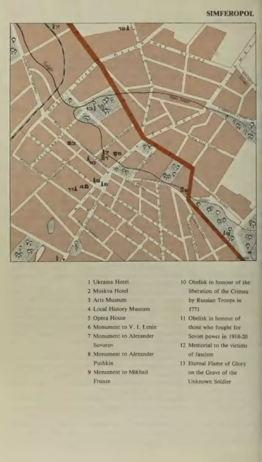
Simferopol
Yalta
Novaya Kakhovka
Itinerary No.
1
()
Itinerary No.
1]
169
171
173
175
179
183
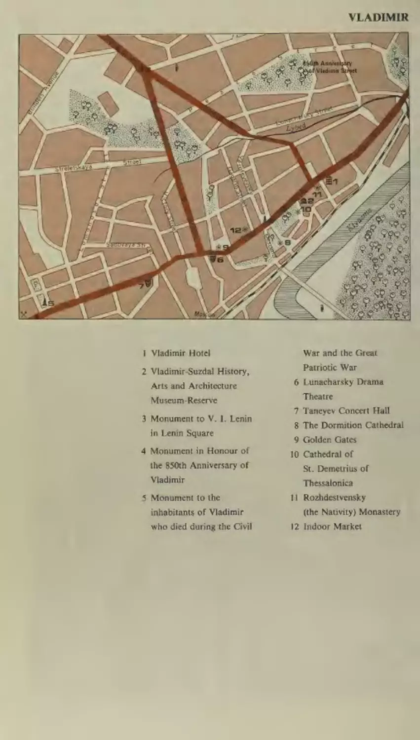
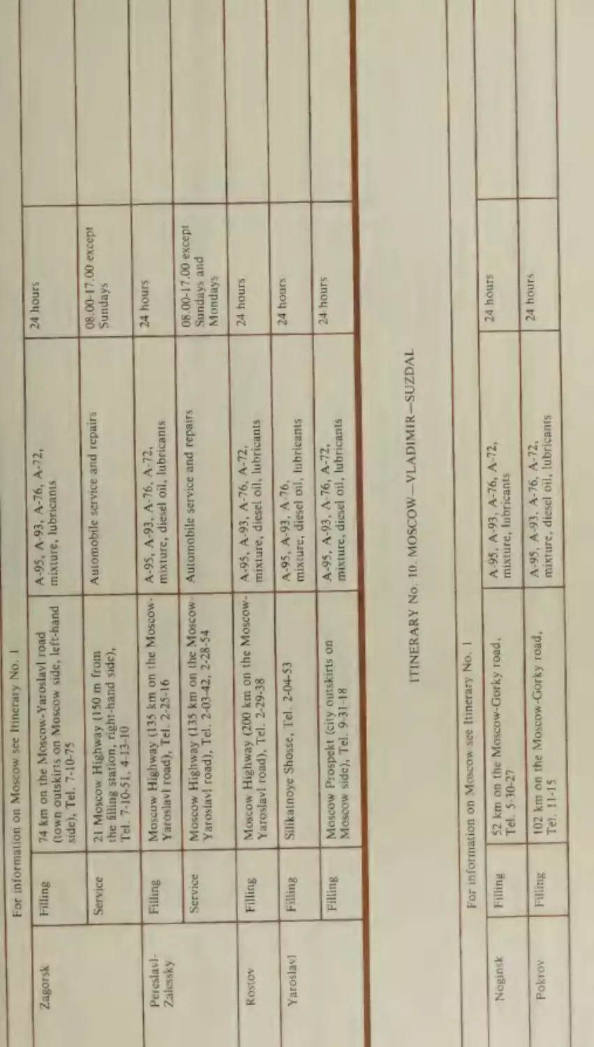
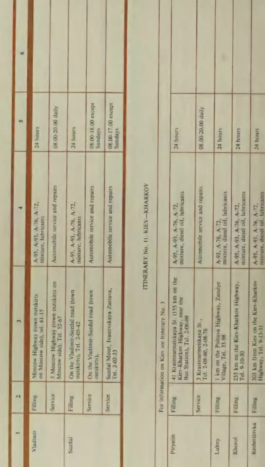
Moscow— Vladimir—Suzdal
Vladimir
Suzdal
186
190
197
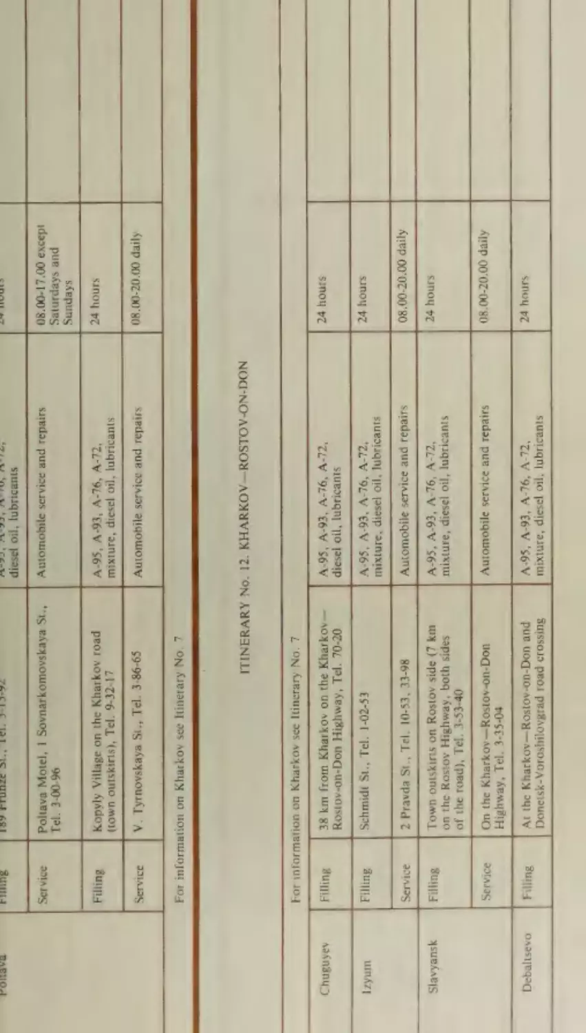
Kiev—Kharkov
Lubny
Poltava
163
165
166
167
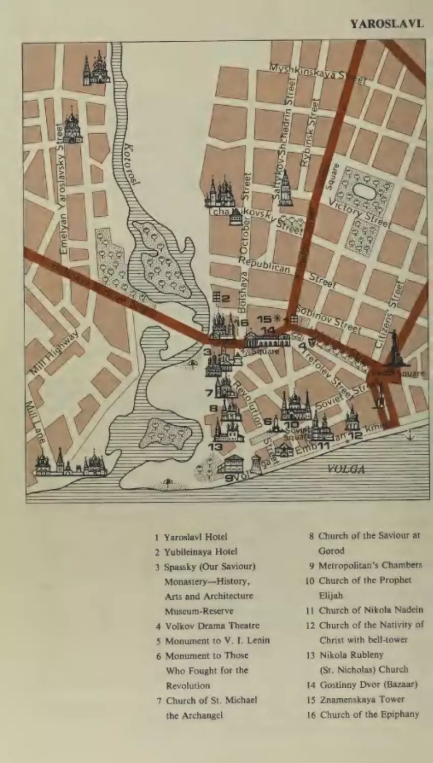
Moscow— Yaroslavl
Zagorsk
Pereslavl-Zalessky
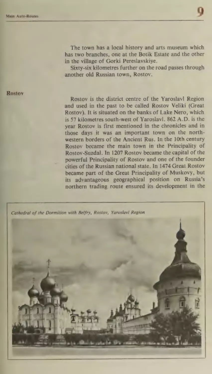
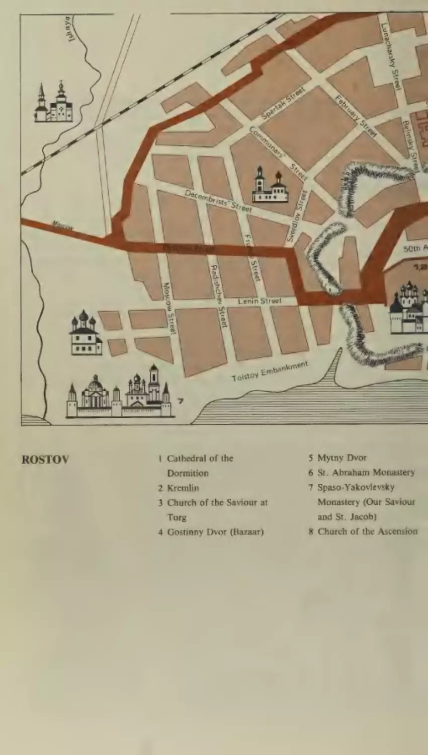
Rostov
Yaroslavl
139
143
146
147
151
154
155
158
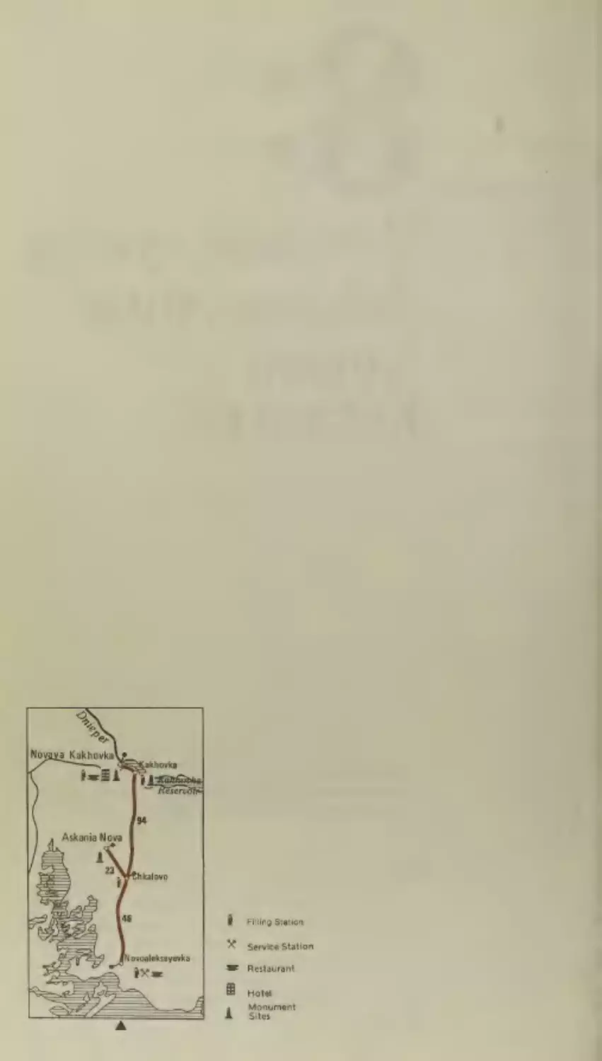
Novoalekseyevka—Askania Nova—
Novaya Kakhovka
Kakhovka
9
133
135
136
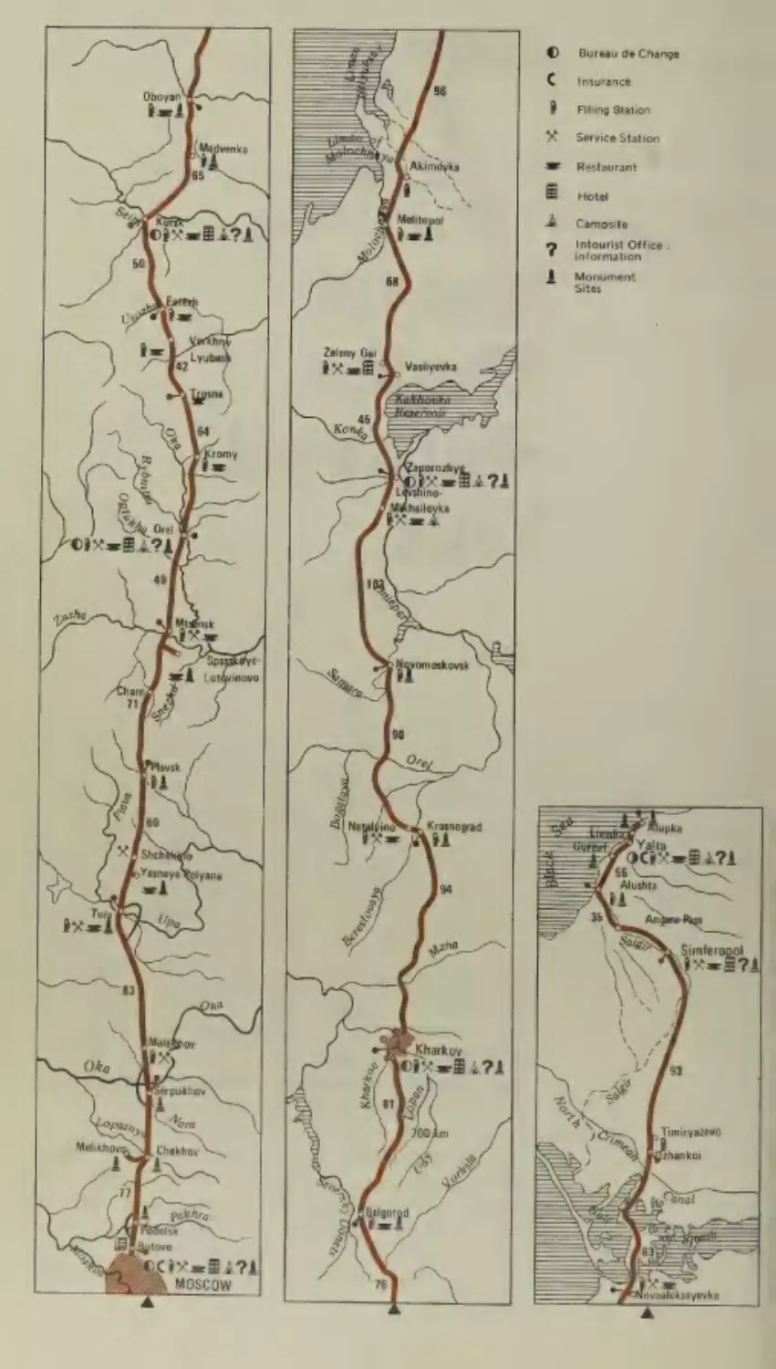
Moscow—Kharkov—Simferopol—Yalta
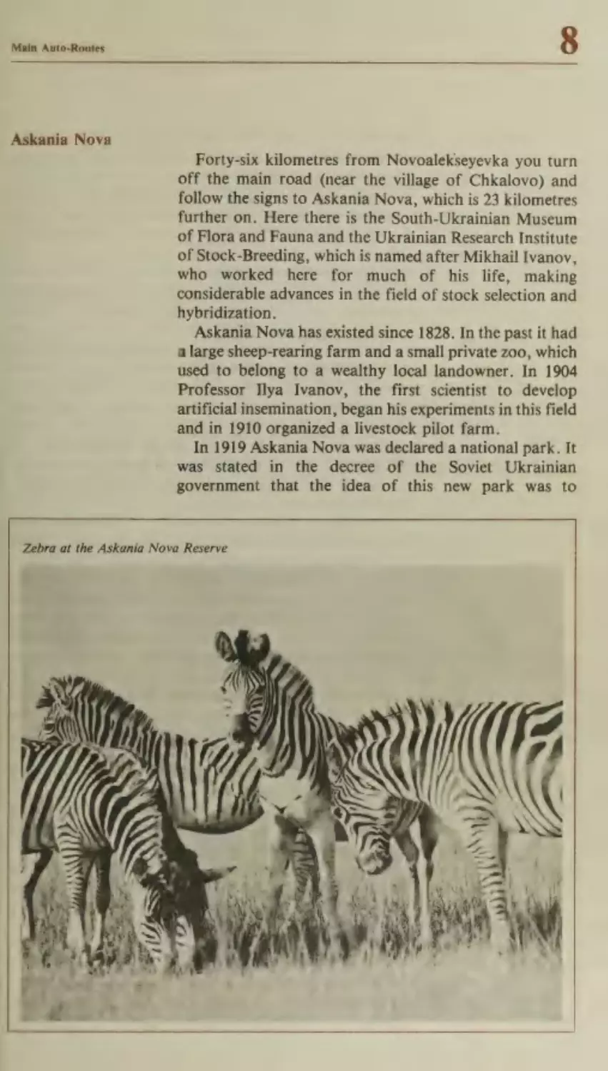
Askania Nova
Itinerary No.
19
121
124
124
125
131
131
Kishinev—Chernovtsy
Orgeyev
Beltsy
117
201
201
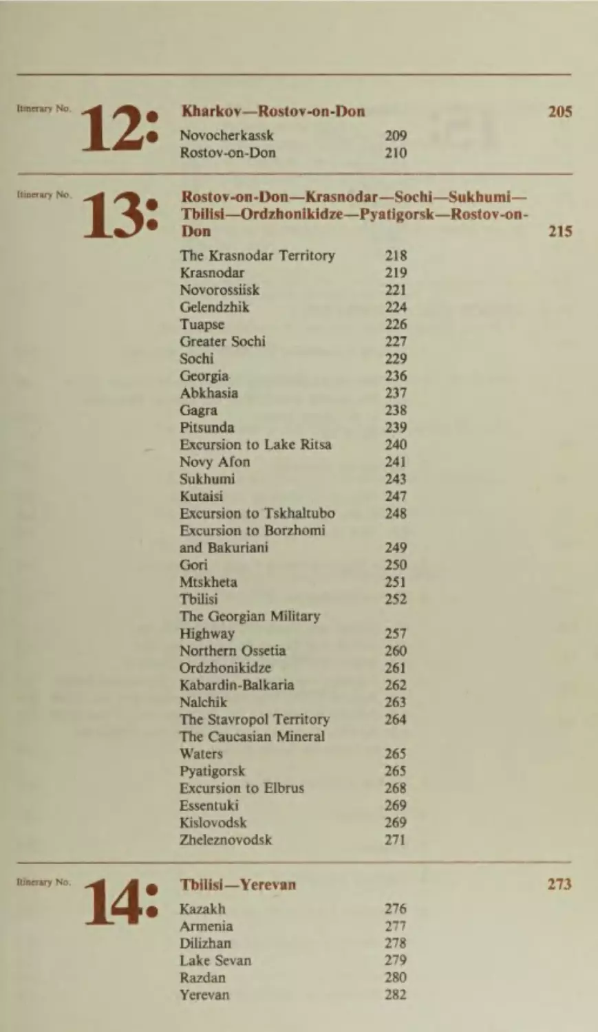
Itinerary No.
1D
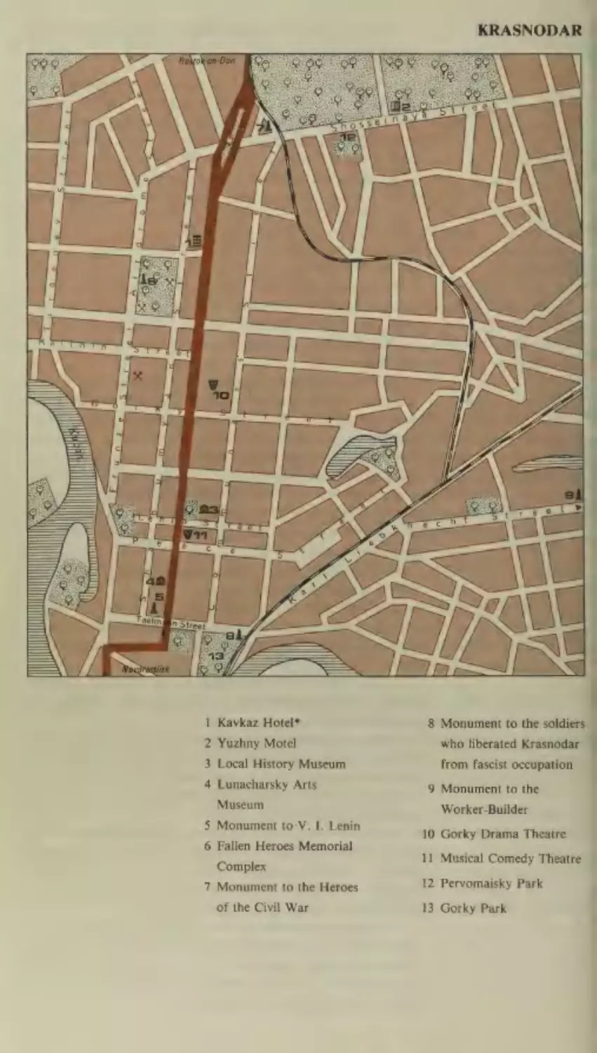
Novocherkassk
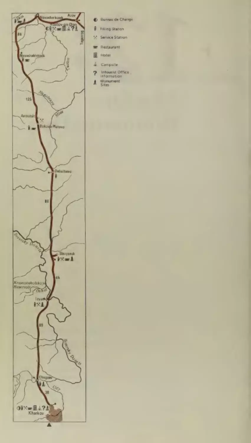
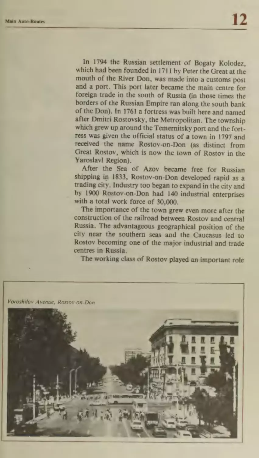
Rostov-on-Don
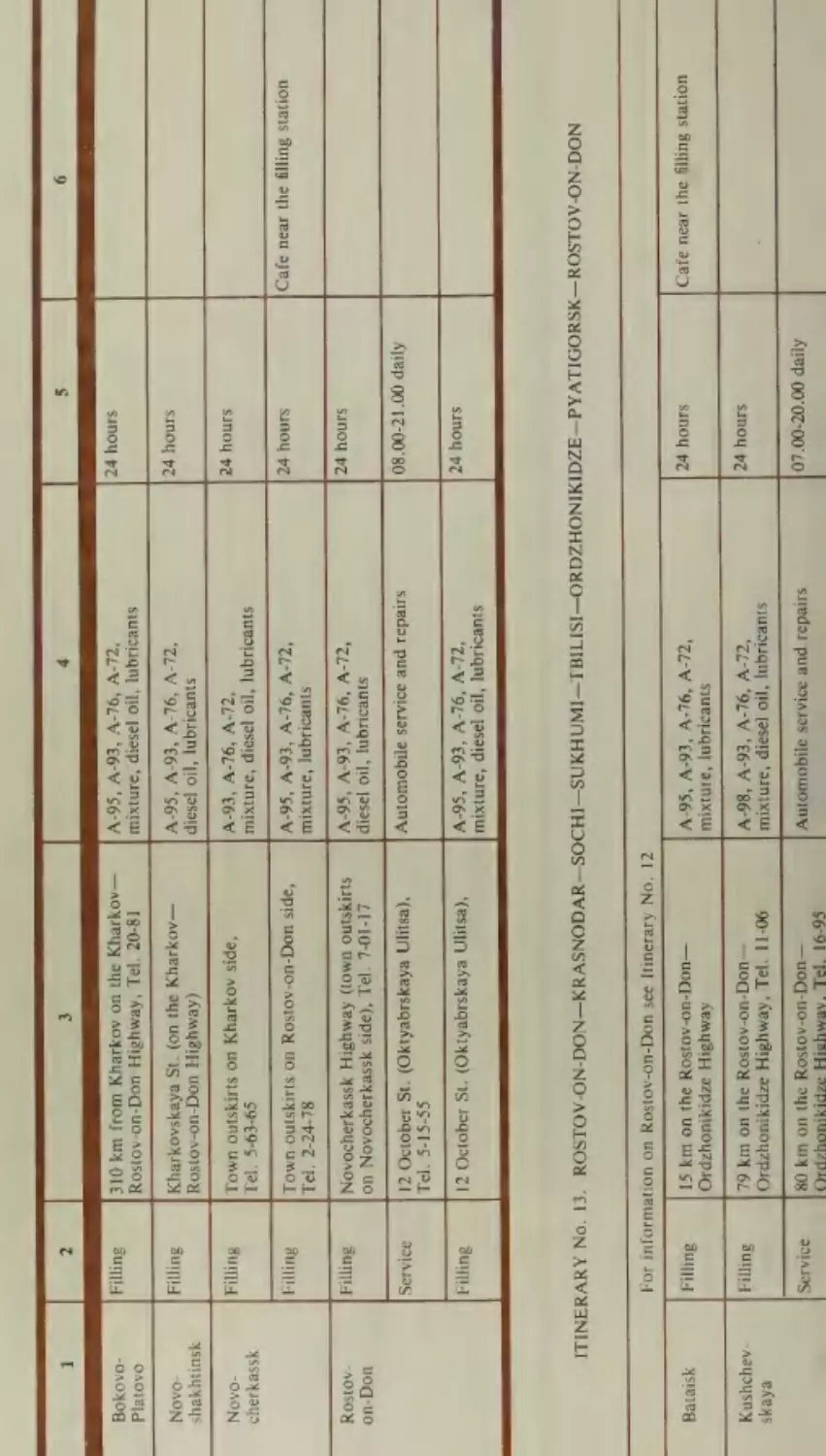
Itinerary No.
13
205
Kharkov—Rostov-on-Don
209
210
Rostov-on-Don—Krasnodar—Sochi—Sukhumi—
Tbilisi— Ordzhonikidze—Pyatigorsk—Rostov-on-
215
Don
The Krasnodar Territory
Krasnodar
Novorossiisk
Gelendzhik
Tuapse
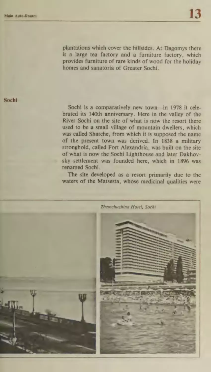
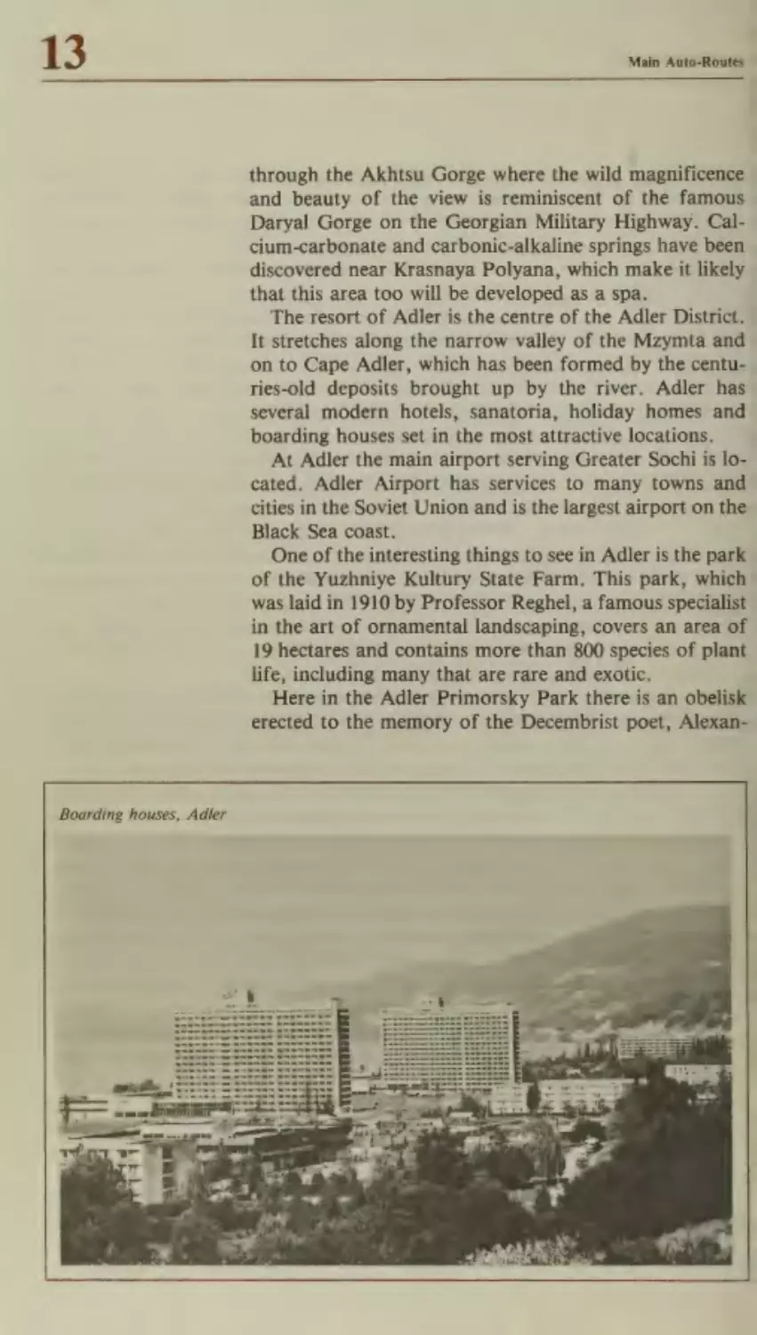
Greater Sochi
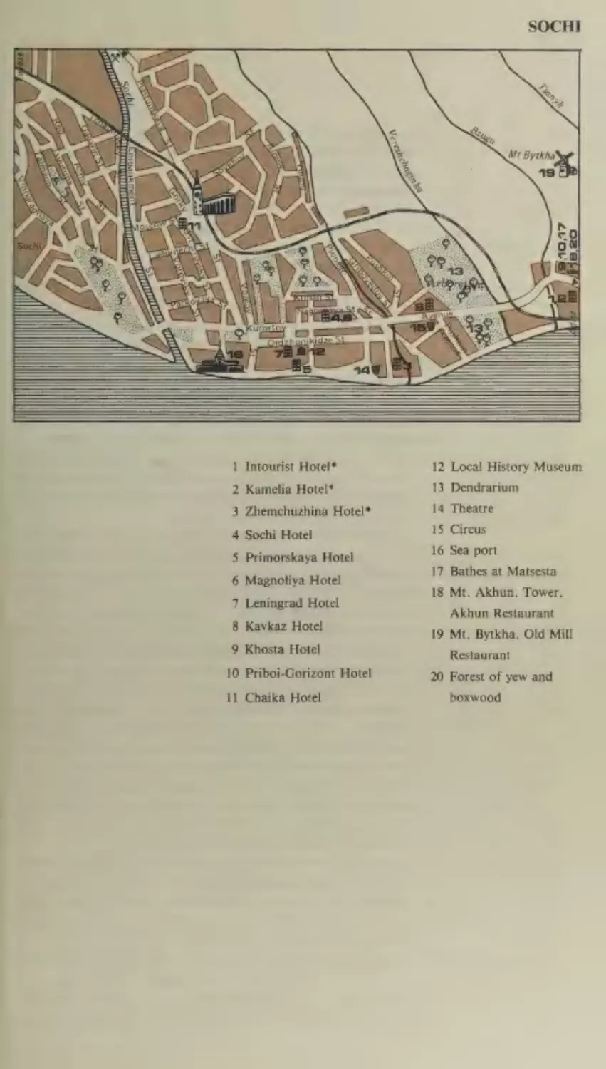
Sochi
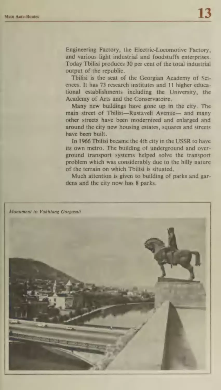
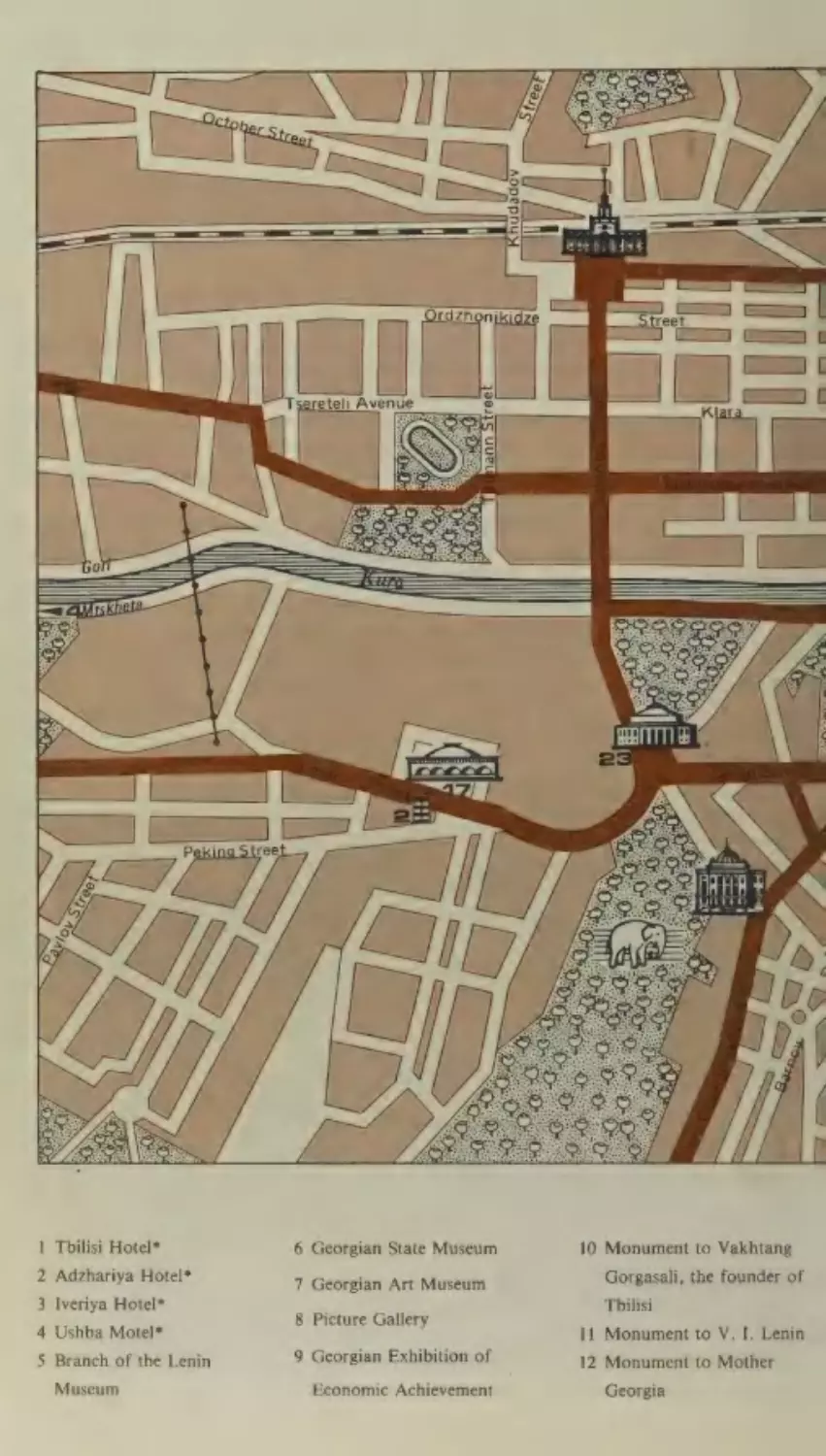
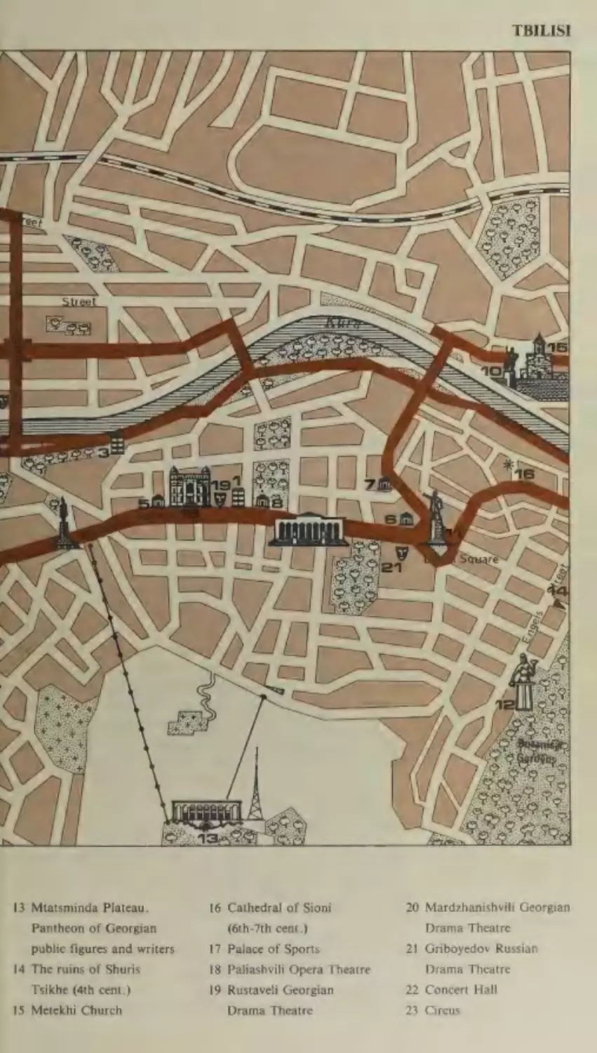
Georgia.
Abkhasia
Gagra
Pitsunda
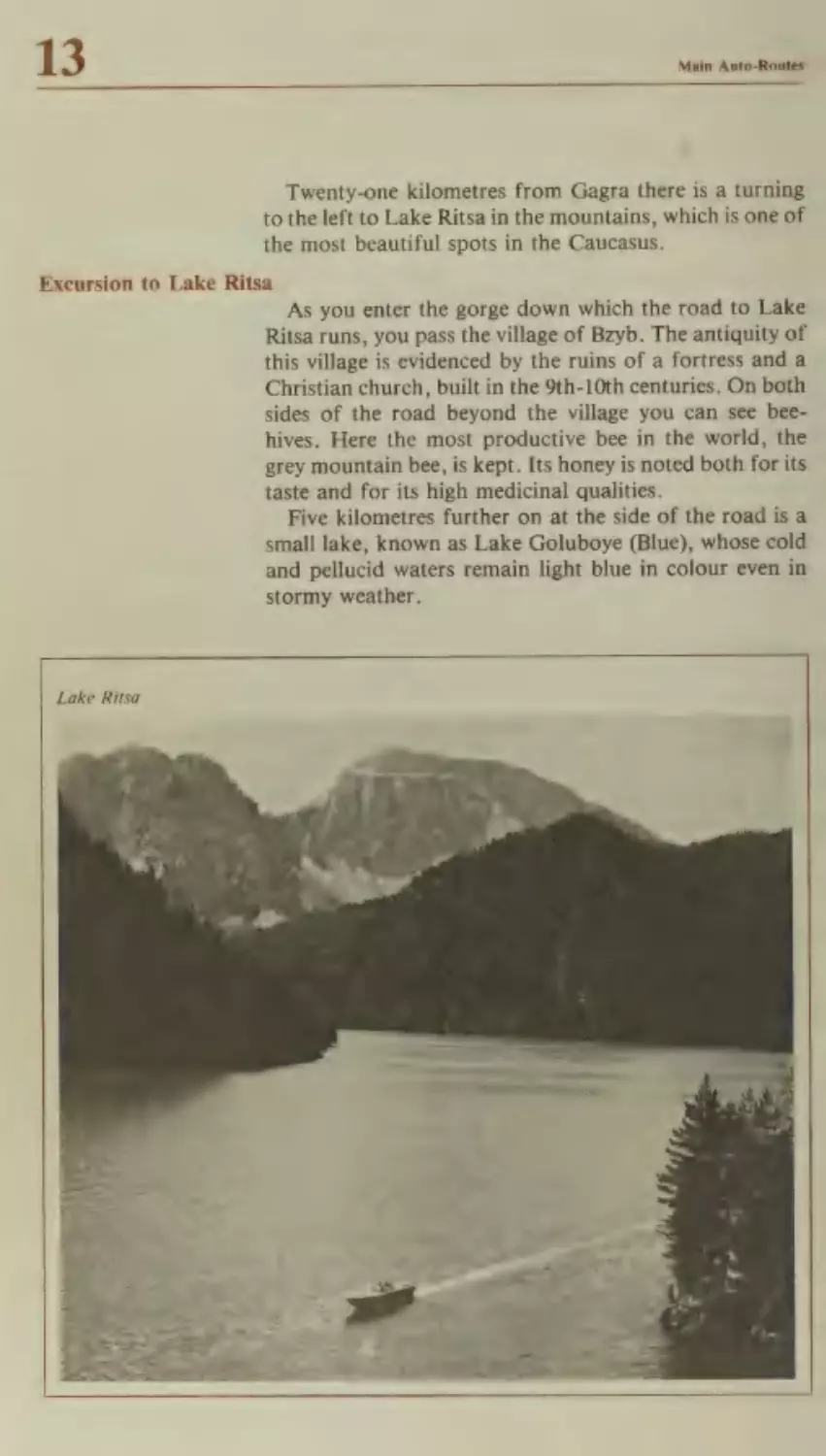
Excursion to Lake Ritsa
Novy Afon
Sukhumi
Kutaisi
Excursion to Tskhaltubo
Excursion to Borzhomi
and Bakuriani
Gori
Mtskheta
Tbilisi
The Georgian Military
Highway
Northern Ossetia
Ordzhonikidze
Kabardin-Balkaria
Nalchik
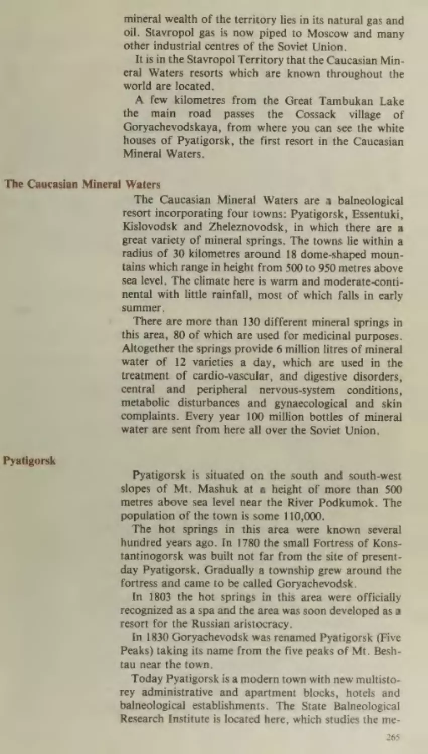
The Stavropol Territory
The Caucasian Mineral
Waters
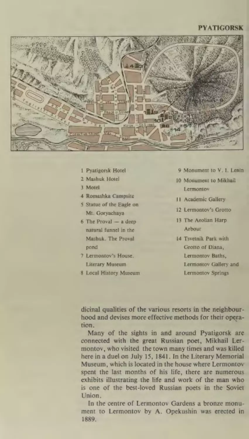
Pyatigorsk
Excursion to Elbrus
Essentuki
Kislovodsk
Zheleznovodsk
Itinerary No. I.
i
218
219
221
224
226
227
229
236
237
238
239
240
241
243
247
248
249
250
251
252
200
260
261
262
263
264
265
265
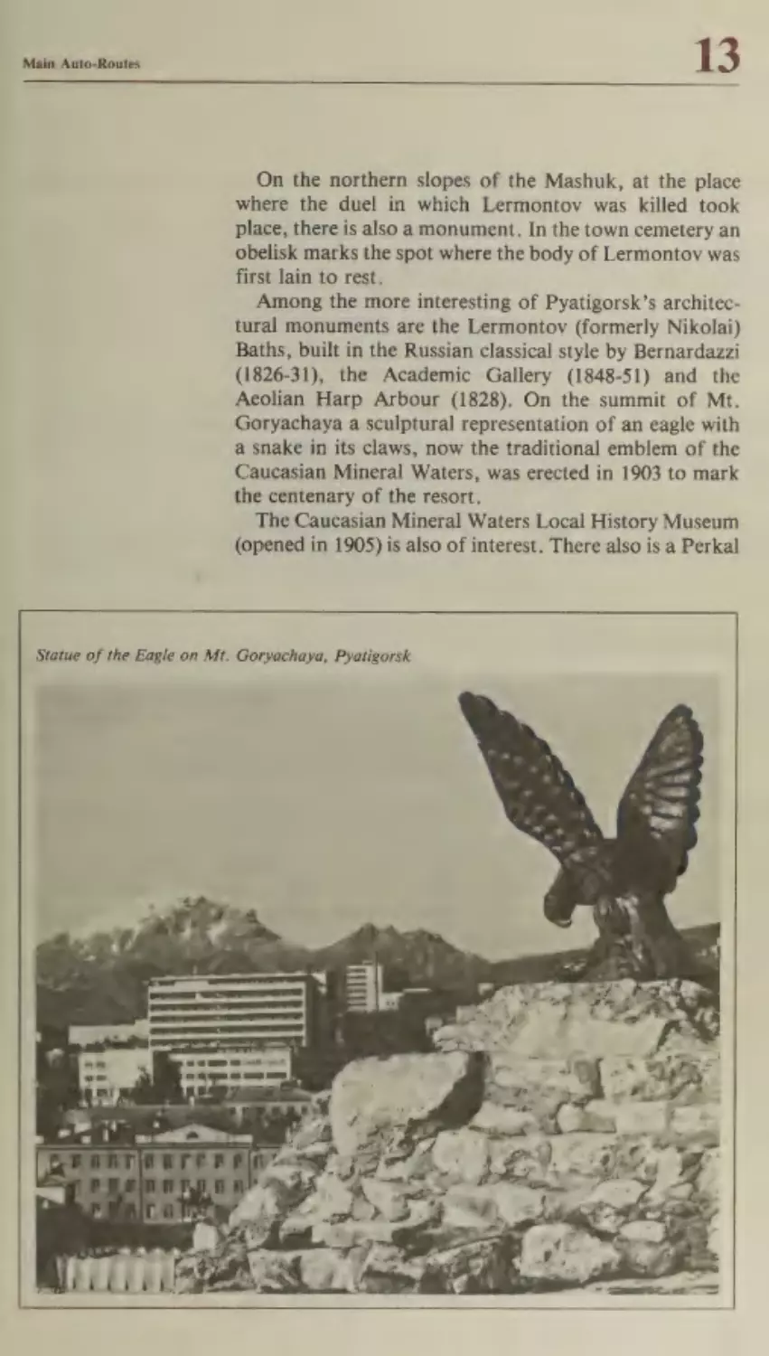
268
269
269
271
273
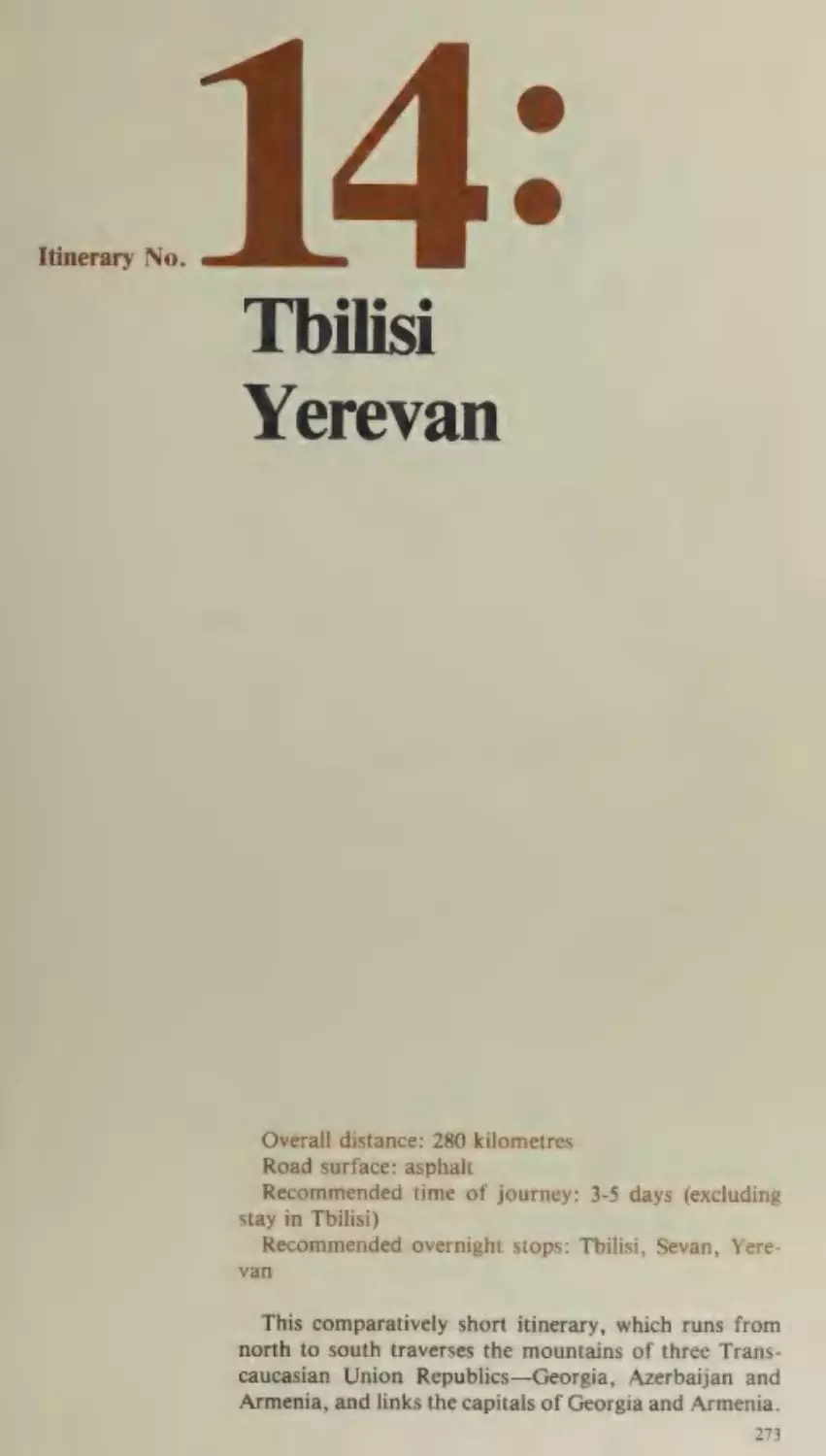
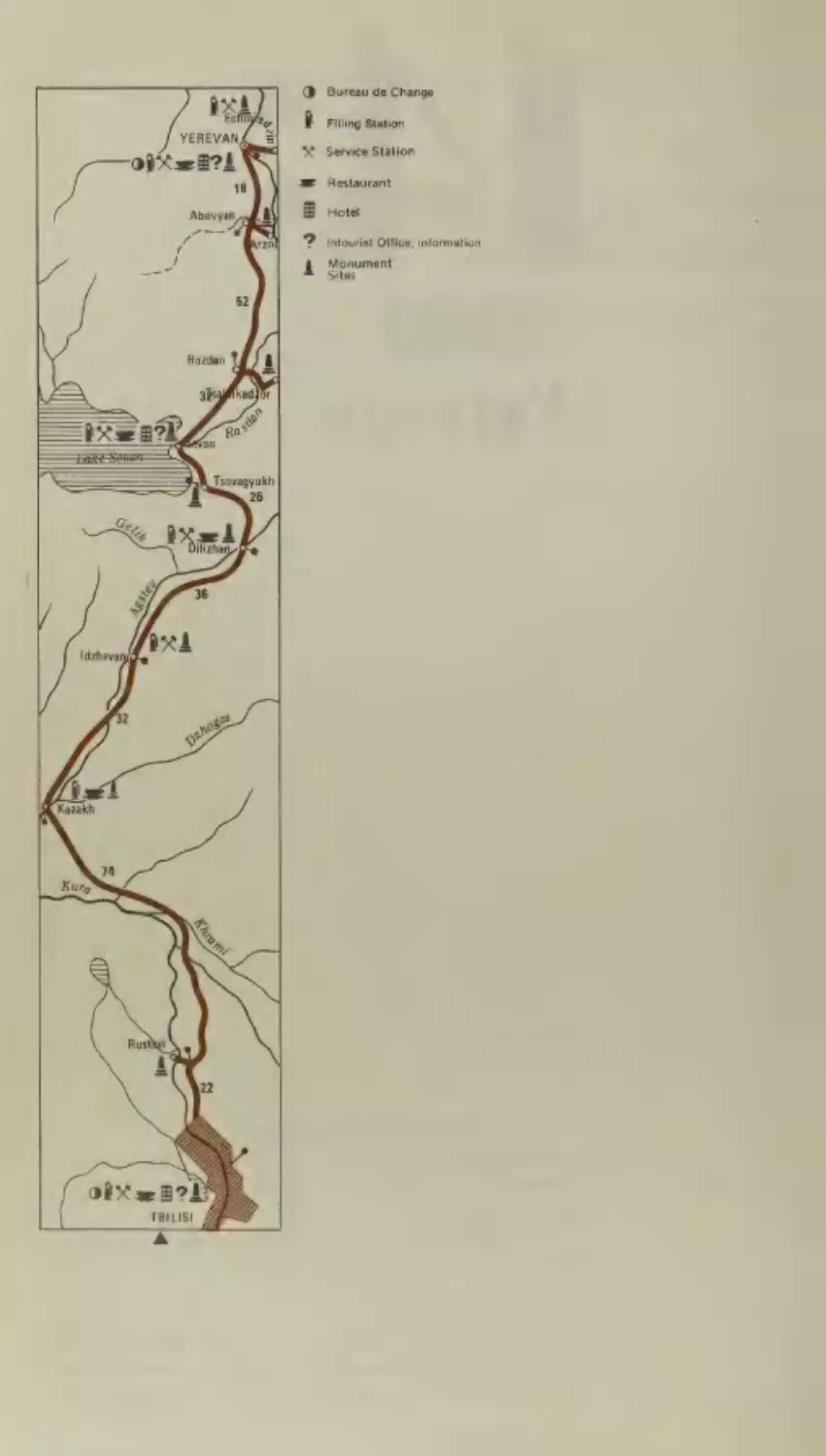
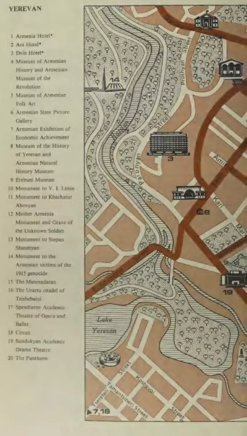
Tbilisi— Yerevan
Kazakh
Armenia
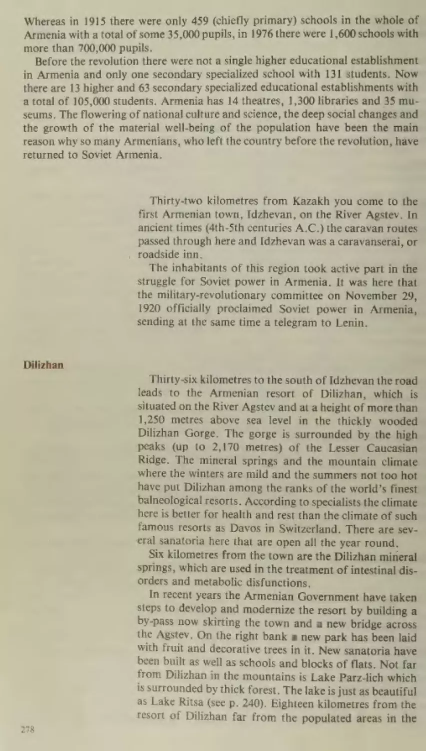
Dilizhan
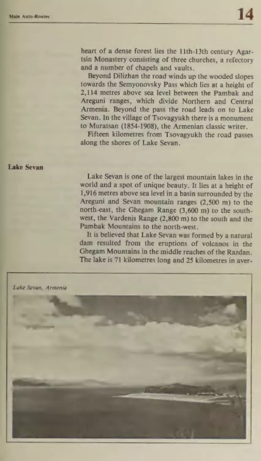
Lake Sevan
Razdan
Yerevan
276
277
278
279
280
282
Beery Te:
@
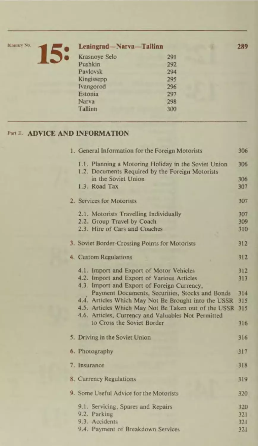
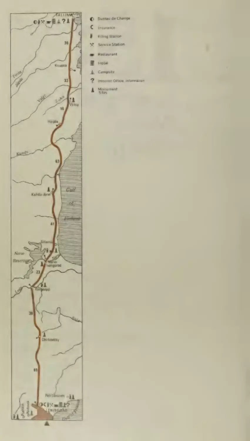
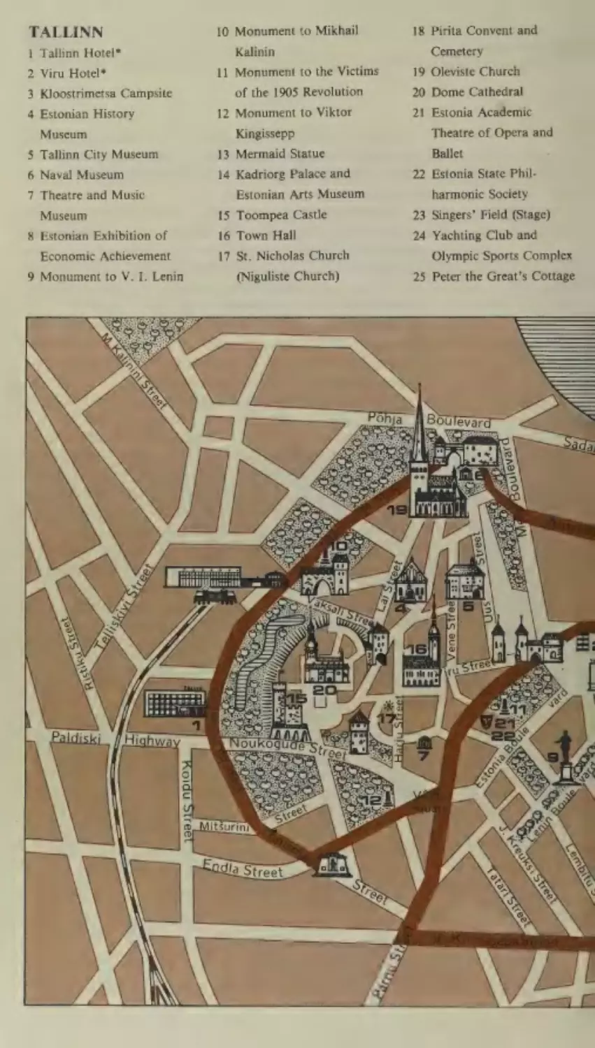
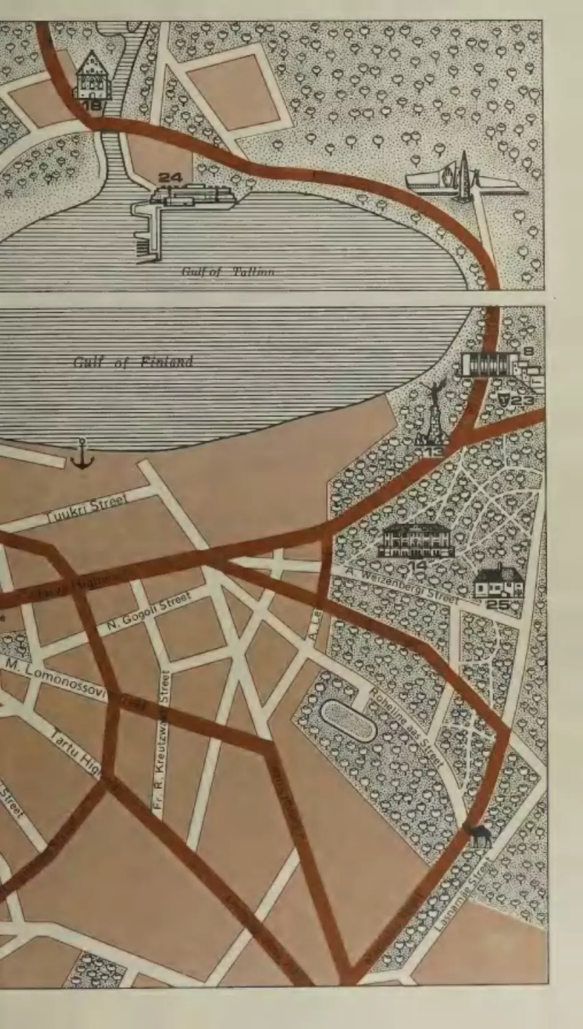
Leningrad—Narva—Tallinn
@
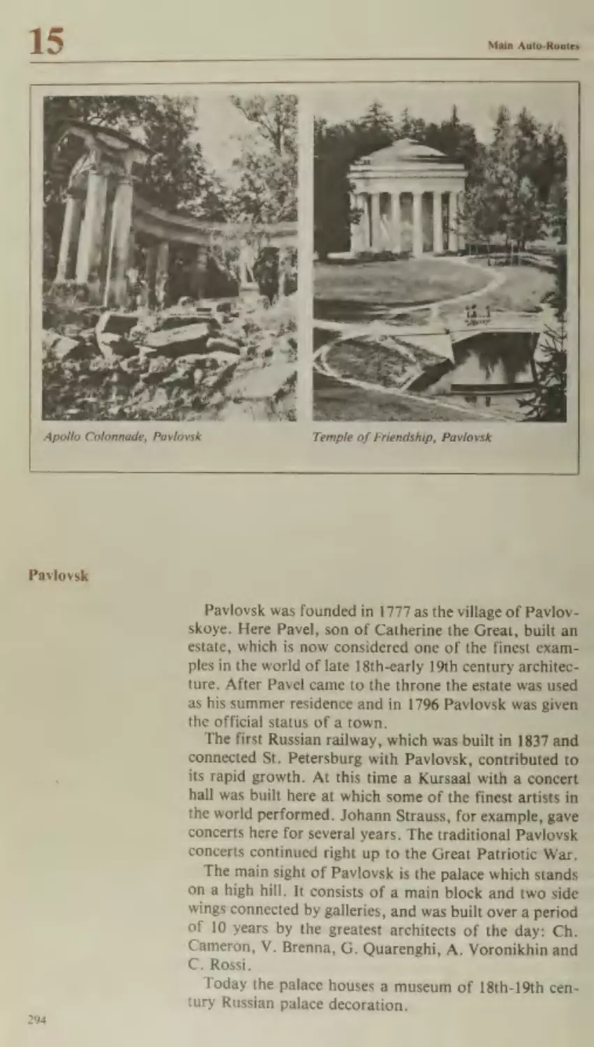
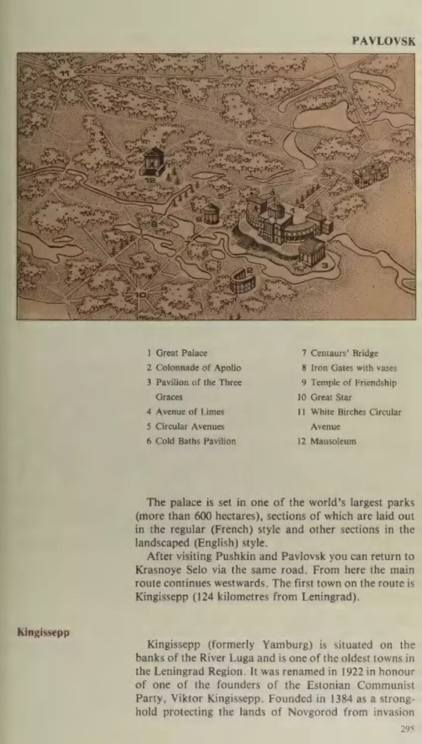
Krasnoye Selo
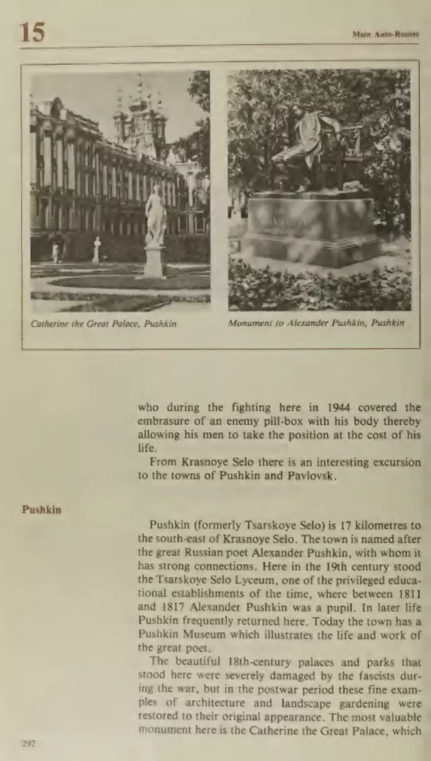
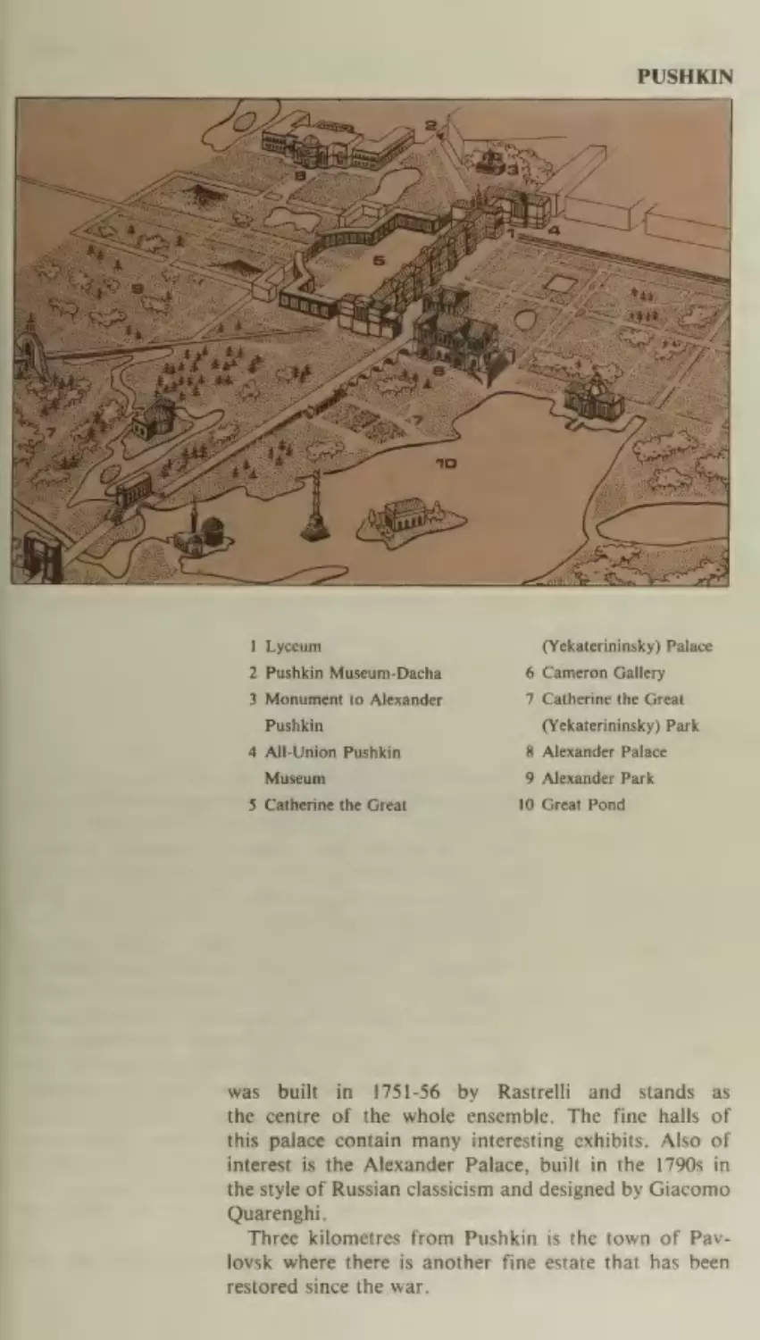
Pushkin
Pavlovsk
Kingissepp
Ivangorod
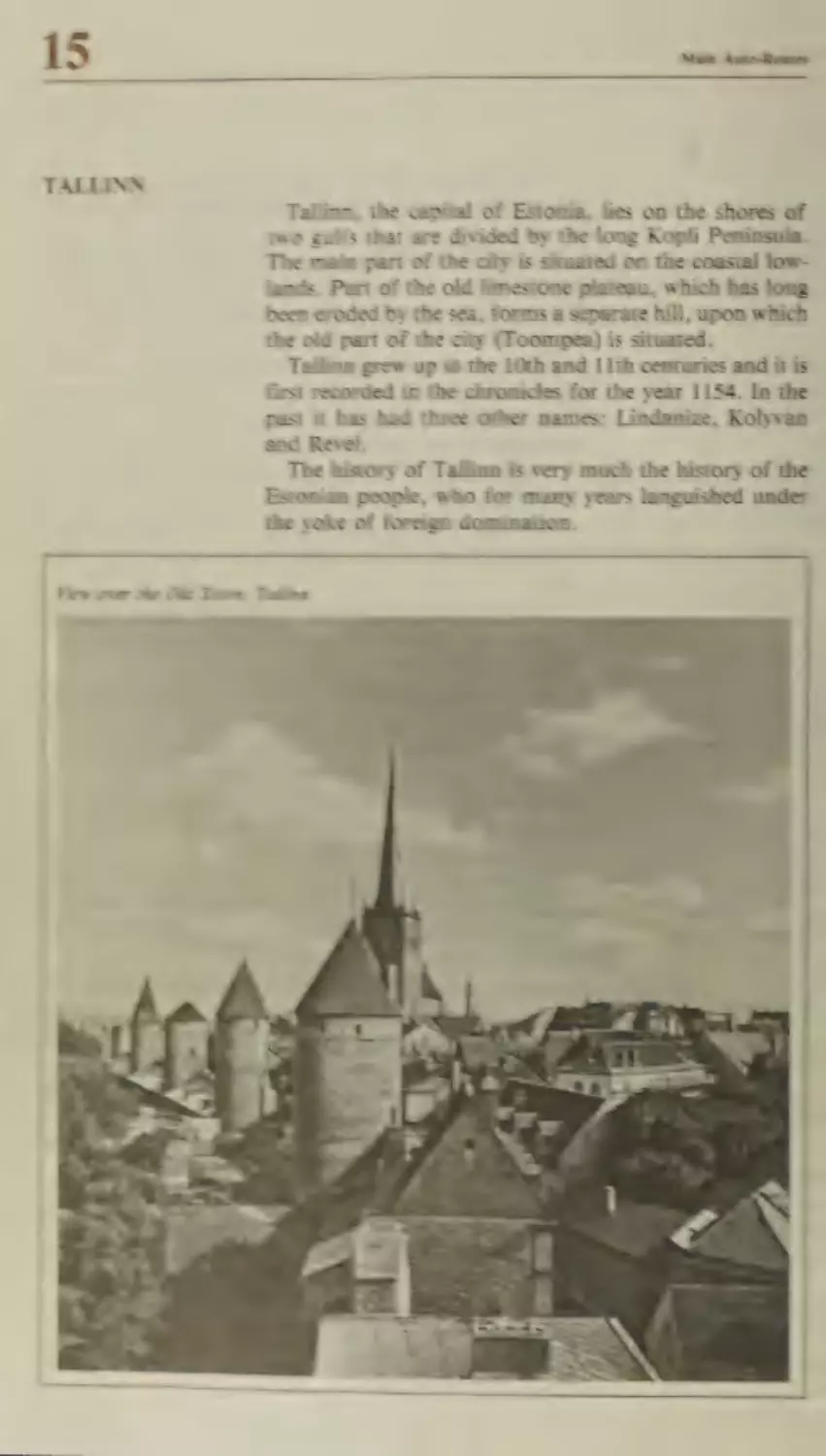
Estonia
Narva
Tallinn
289
291
292
294
295
296
297
298
300
Part I. ADVICE AND INFORMATION
1. General Information for the Foreign Motorists
306
1.1. Planning a Motoring Holiday in the Soviet Union
1.2. Documents Required by the Foreign Motorists
in the Soviet Union
1.3. Road Tax
2. Services for Motorists
306
307
307
2.1. Motorists Travelling Individually
2.2. Group Travel by Coach
2.3. Hire of Cars and Coaches
307
309
310
3. Soviet Border-Crossing Points for Motorists
4. Custom Regulations
306
S12
:
312
4.1. Import and Export of Motor Vehicles
4.2. Import and Export of Various Articles
4.3. Import and Export of Foreign Currency,
Payment Documents, Securities, Stocks and Bonds
312
313
4.5. Articles Which May Not Be Taken out of the USSR
4.6. Articles, Currency and Valuables Not Permitted
to Cross the Soviet Border
315
4.4. Articles Which May Not Be Brought into the USSR
314
315
316
5. Driving in the Soviet Union
316
6. Photography
317
ds Insurance
318
8. Currency Regulations
319
9. Some Useful Advice for the Motorists
320
9.1. Servicing, Spares and Repairs
320
9.2. Parking
9.3. Accidents
321
321
321
9.4. Payment of Breakdown Services
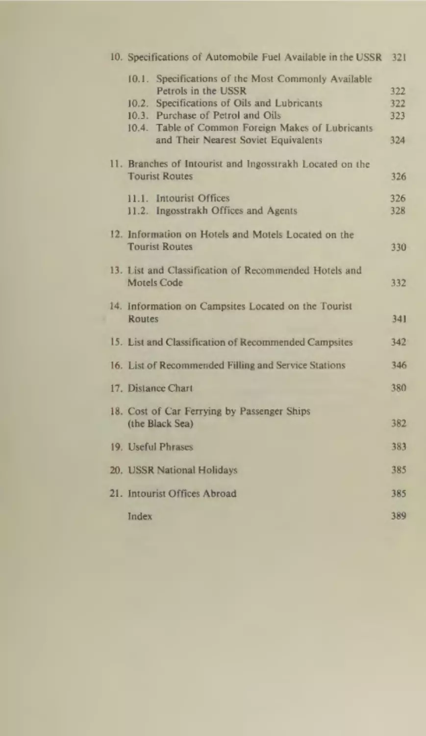
10. Specifications of Automobile Fuel Available inthe USSR
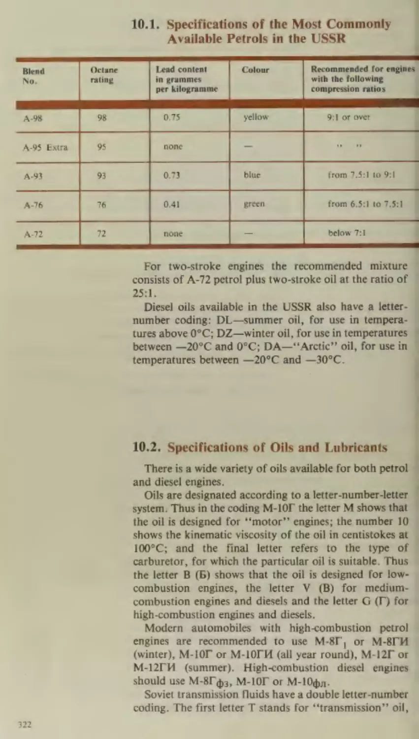
10.1.
10.2.
10.3.
10.4.
321
Specifications of the Most Commonly Available
Petrols in the USSR
Specifications of Oils and Lubricants
Purchase of Petrol and Oils
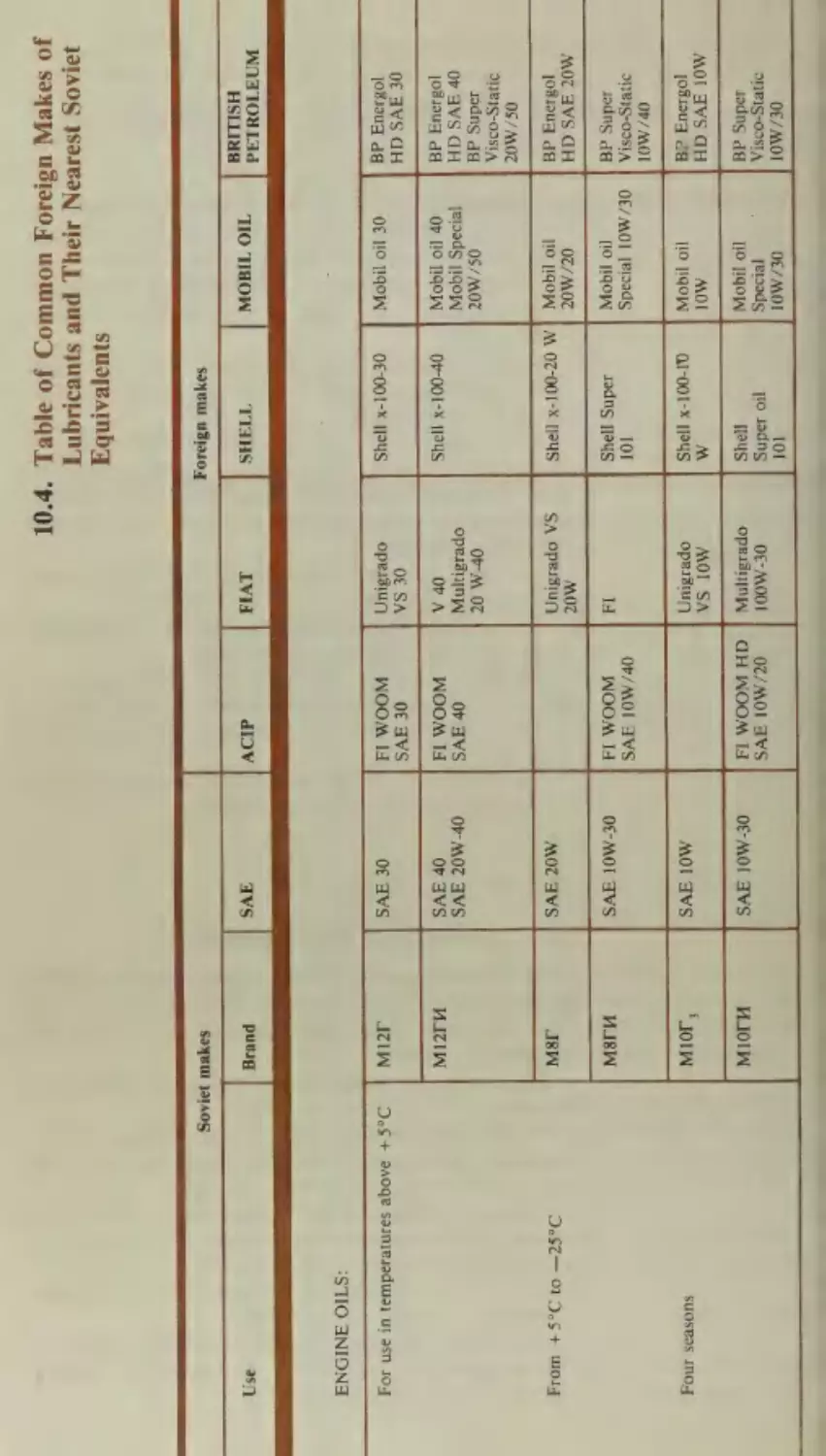
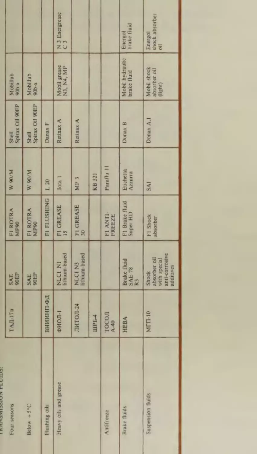
Table of Common Foreign Makes of Lubricants
and Their Nearest Soviet Equivalents
322.
322
523
324
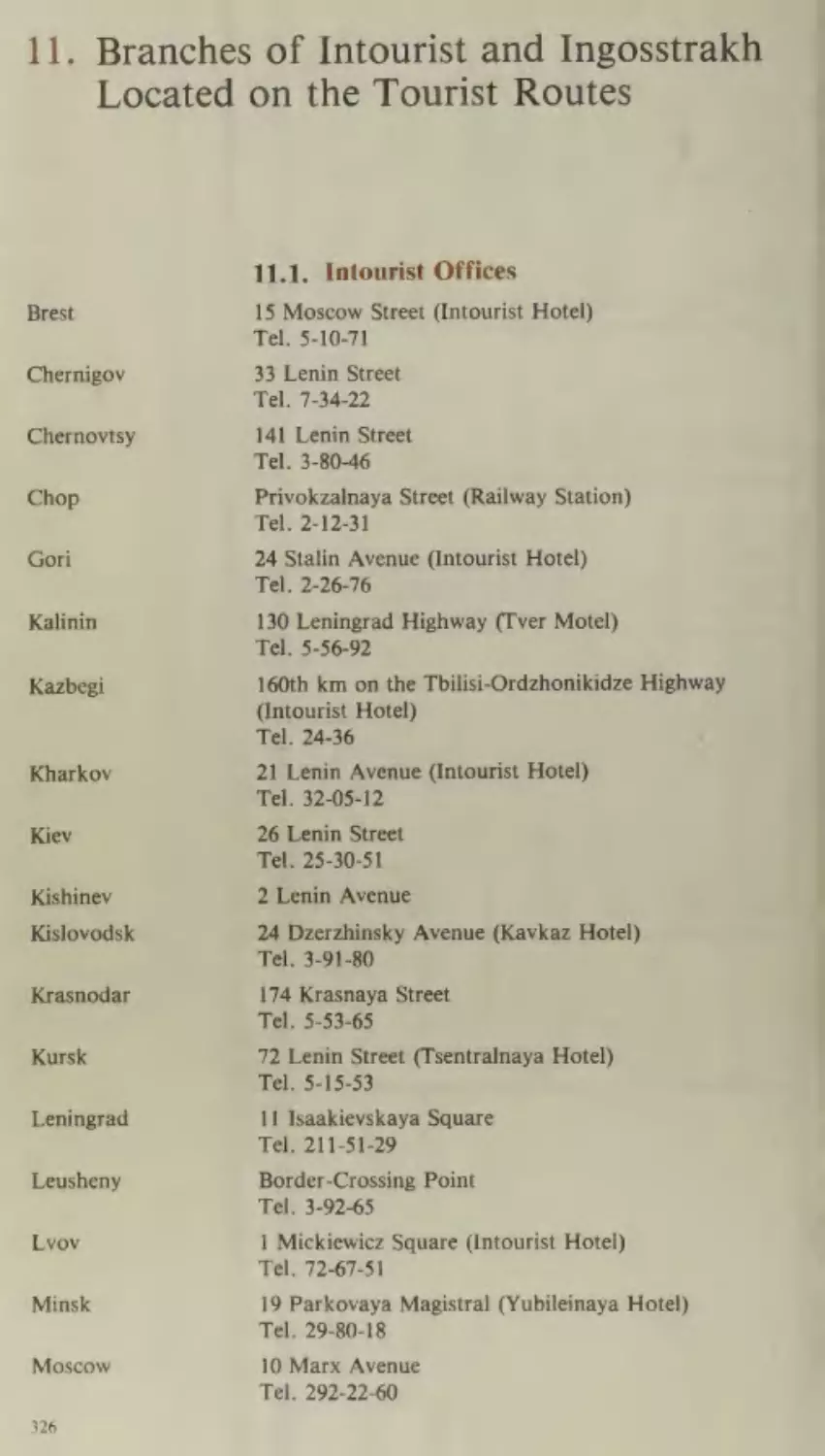
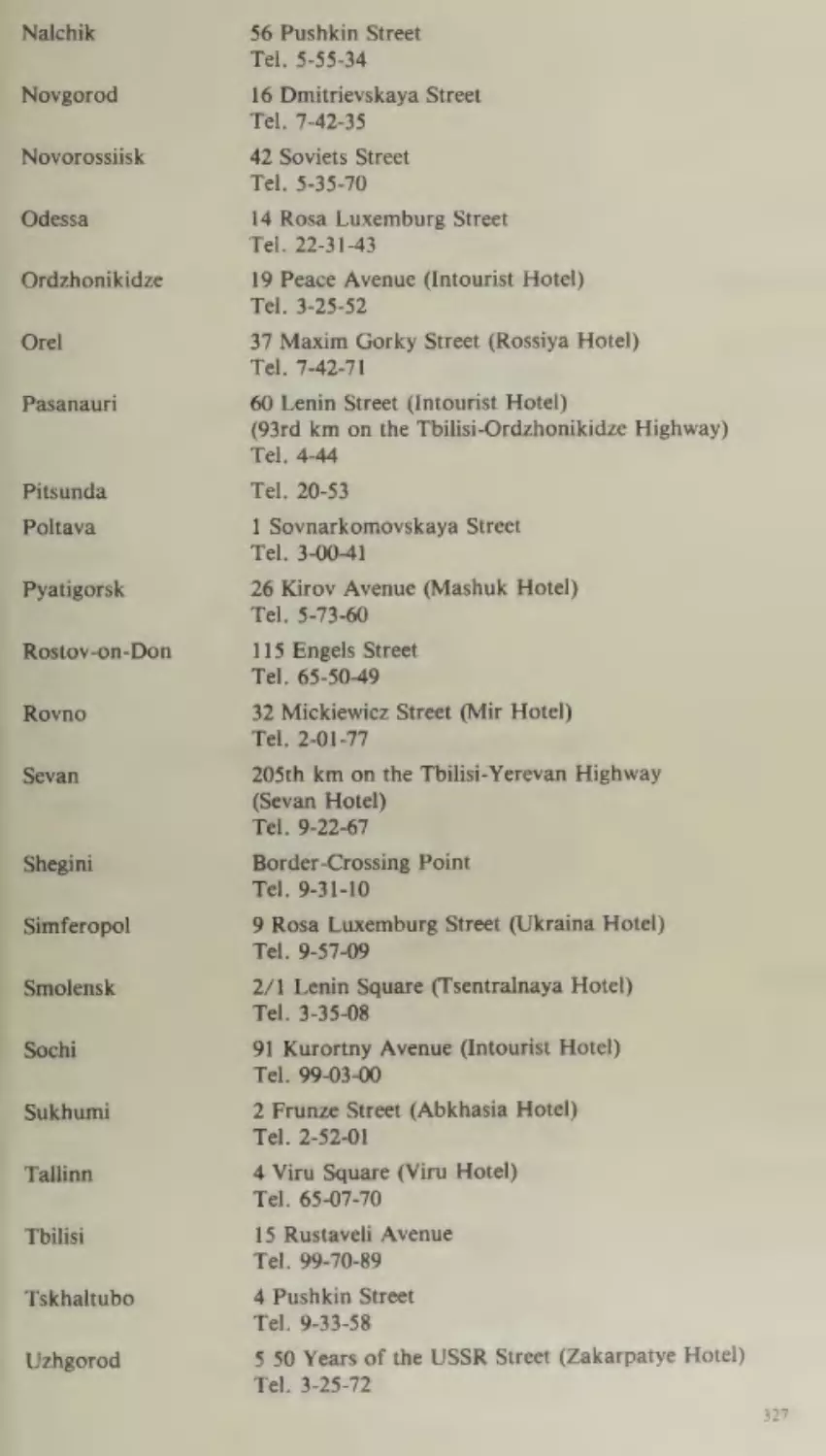
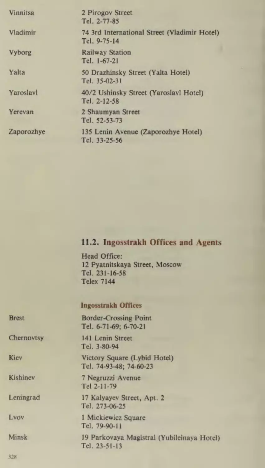
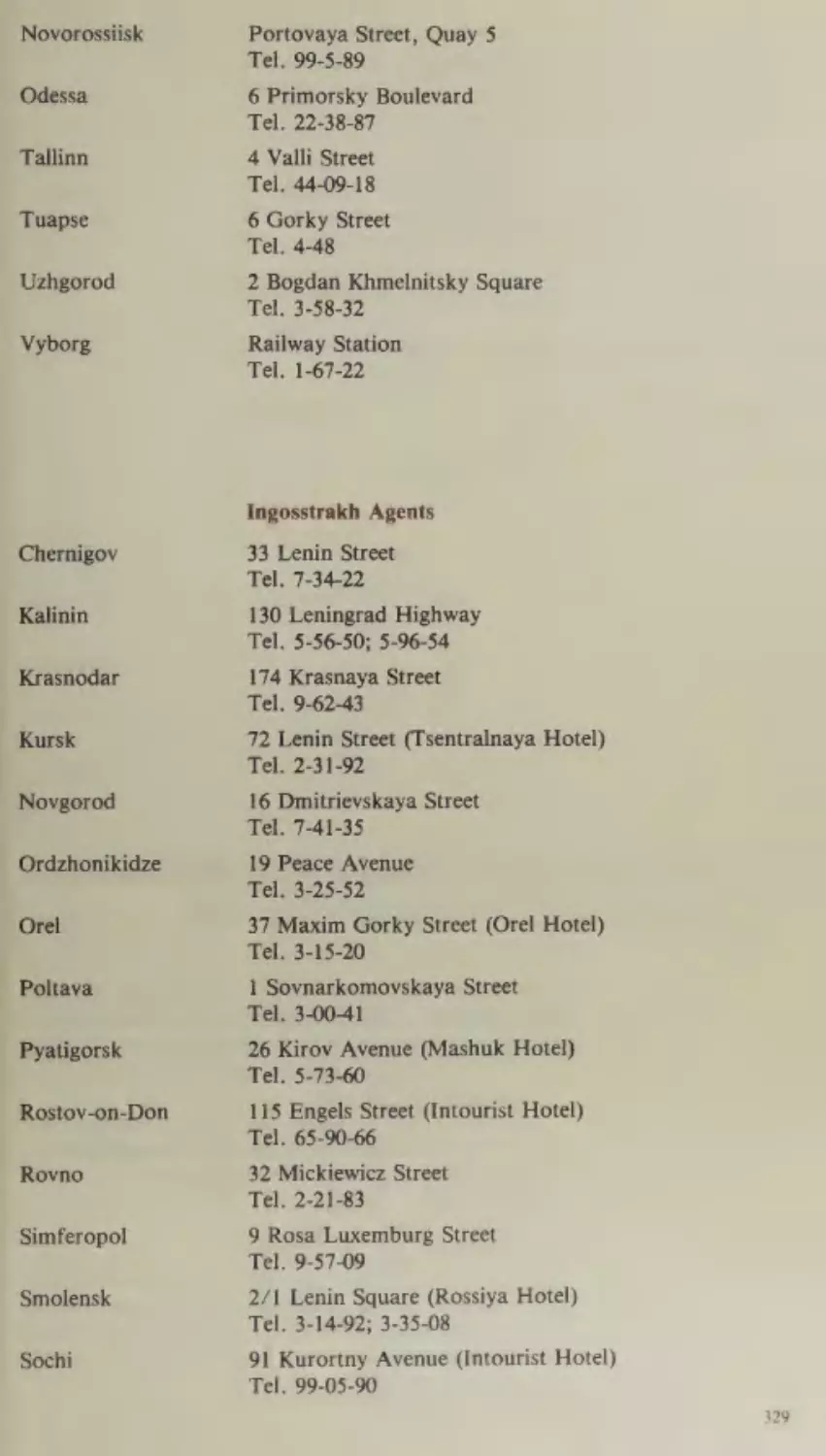
ae Branches of Intourist and Ingosstrakh Located on the
Tourist Routes
11.1.
11.2.
326
Intourist Offices
Ingosstrakh Offices and Agents
326
_ 328
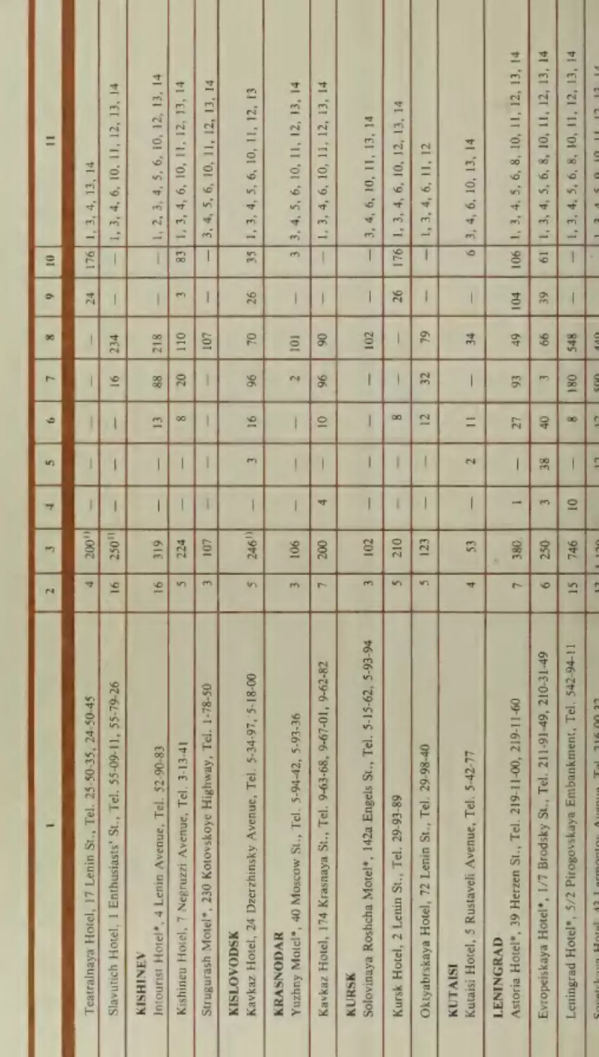
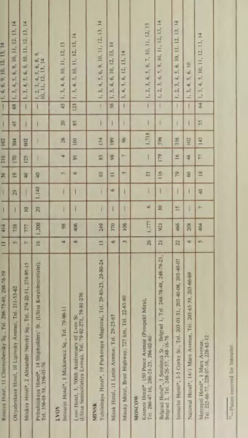
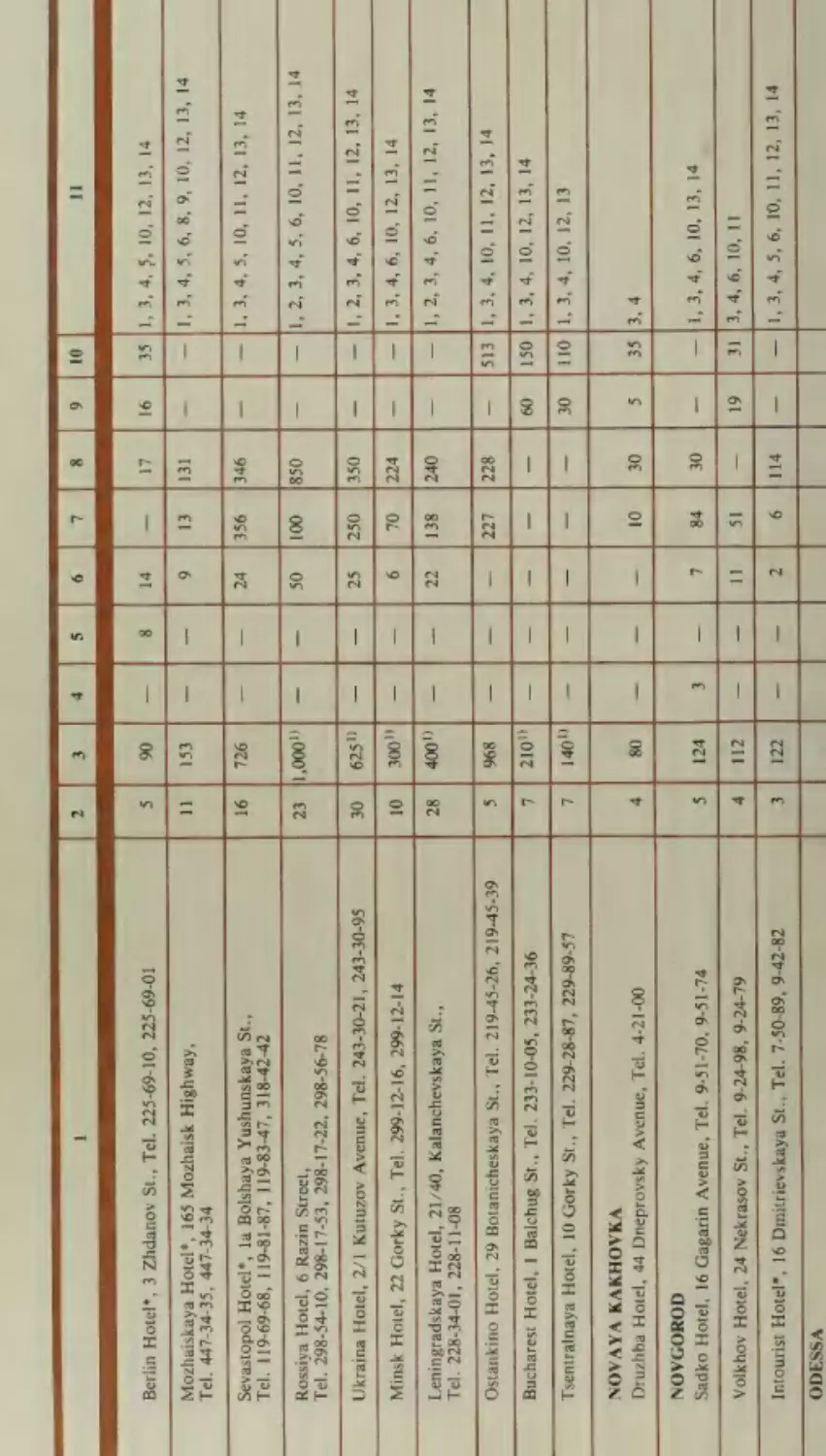
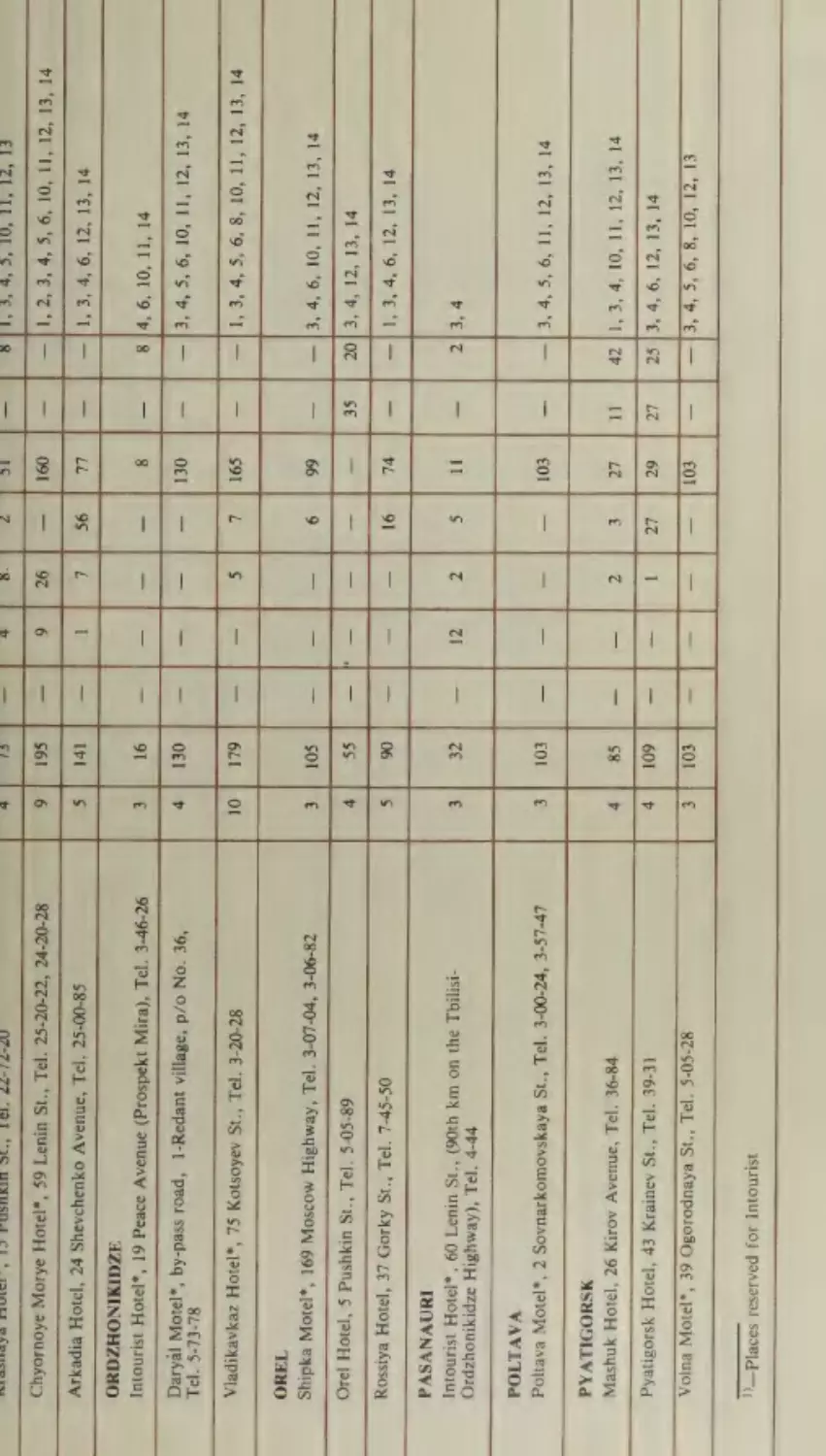
12: Information on Hotels and Motels Located on the
Tourist Routes
330
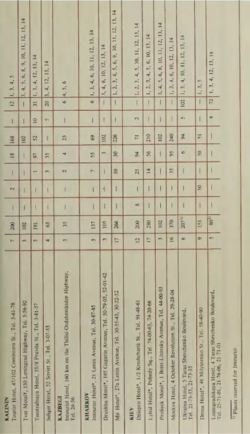
1: List and Classification of Recommended Hotels and
Motels Code
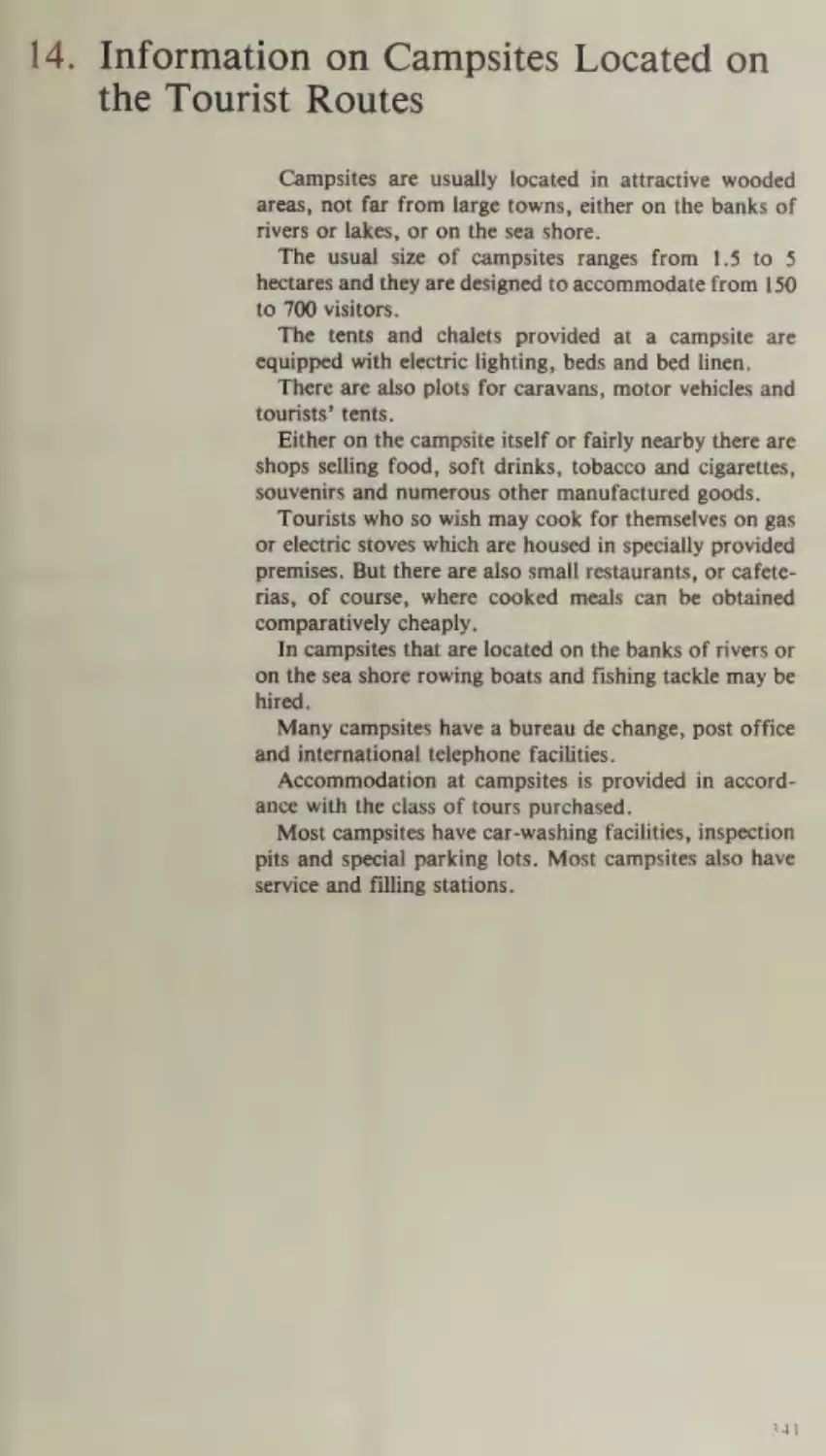
14. Information on Campsites Located on the Tourist
Routes
332
|
341
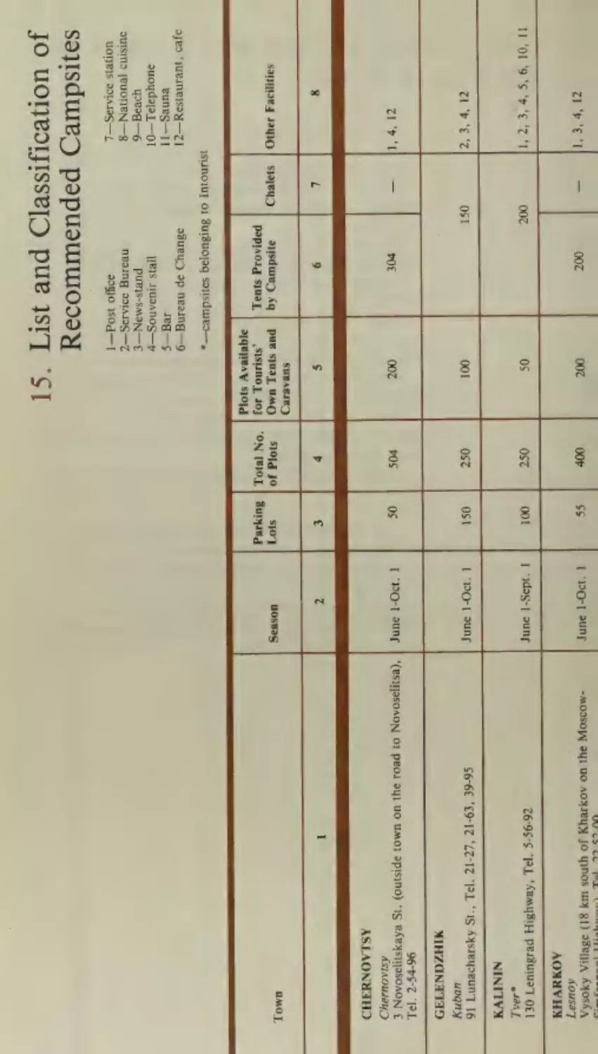
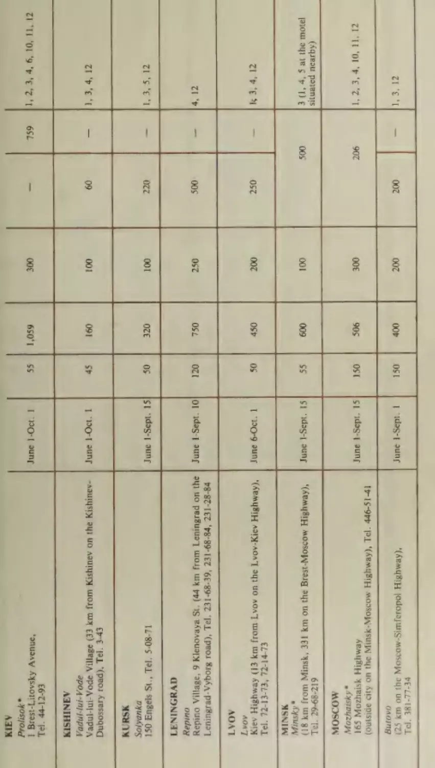
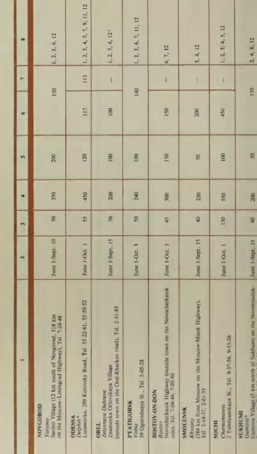
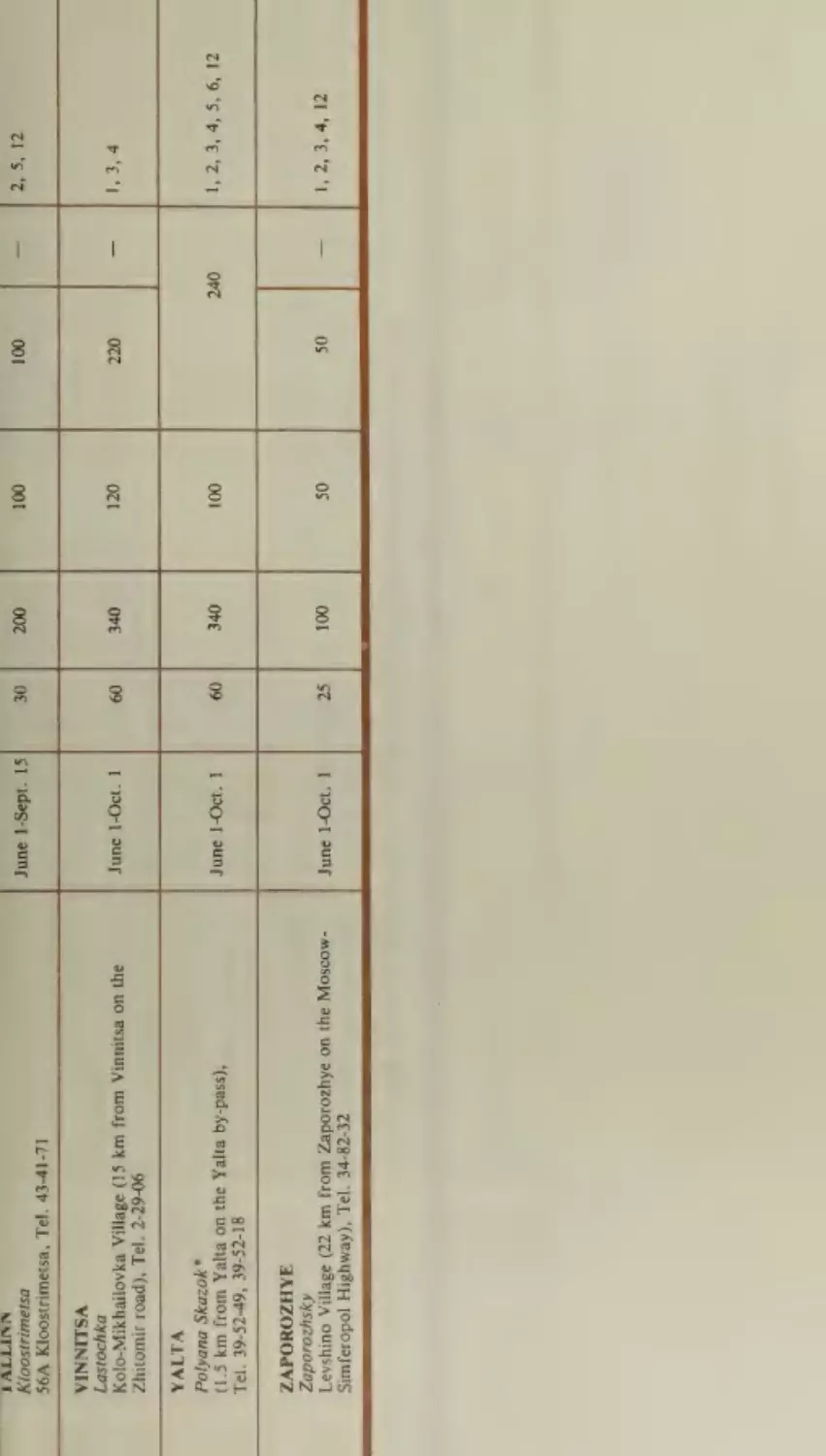
15: List and Classification of Recommended Campsites
342
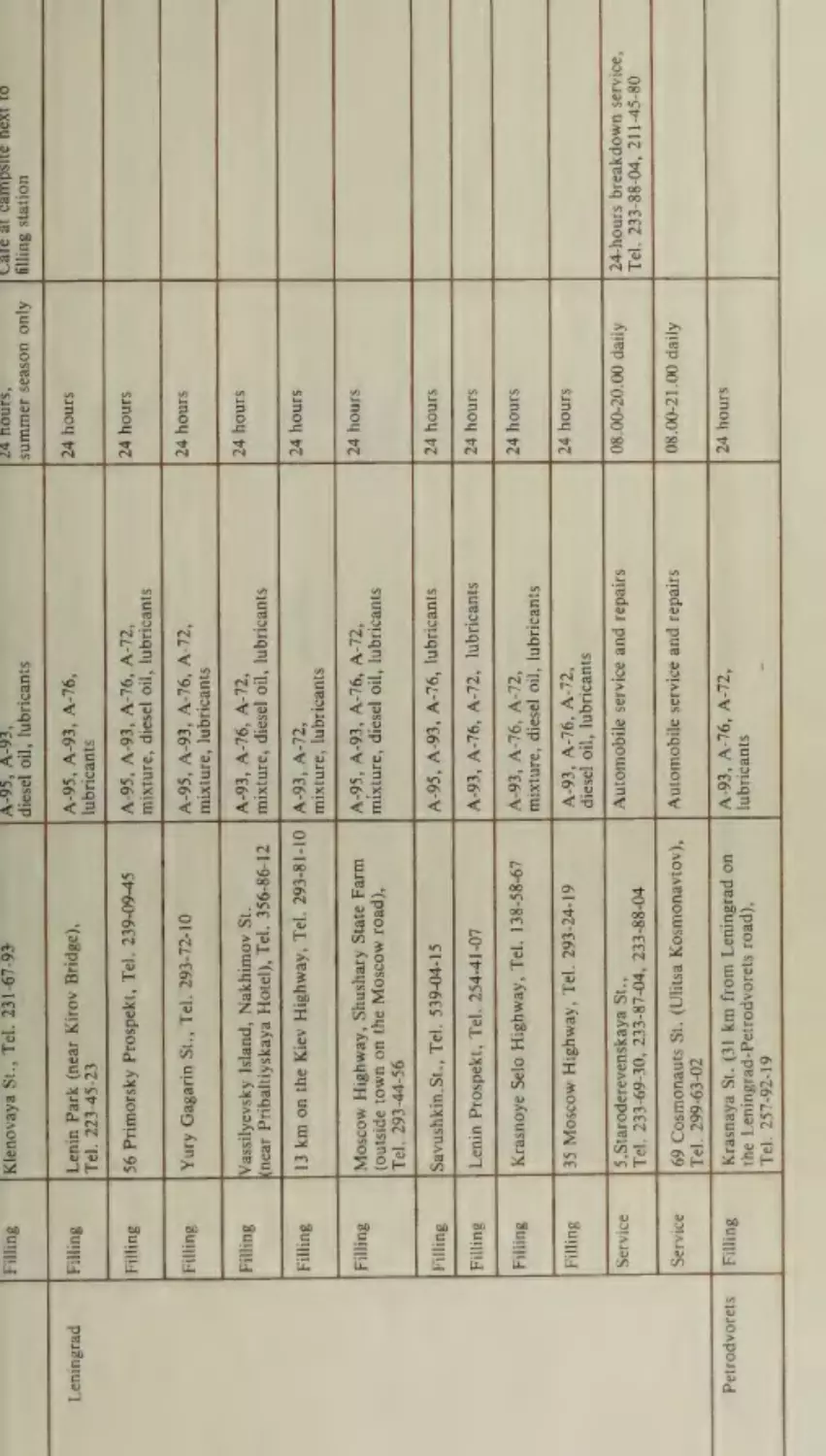
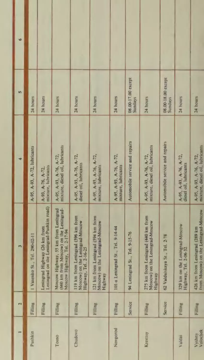
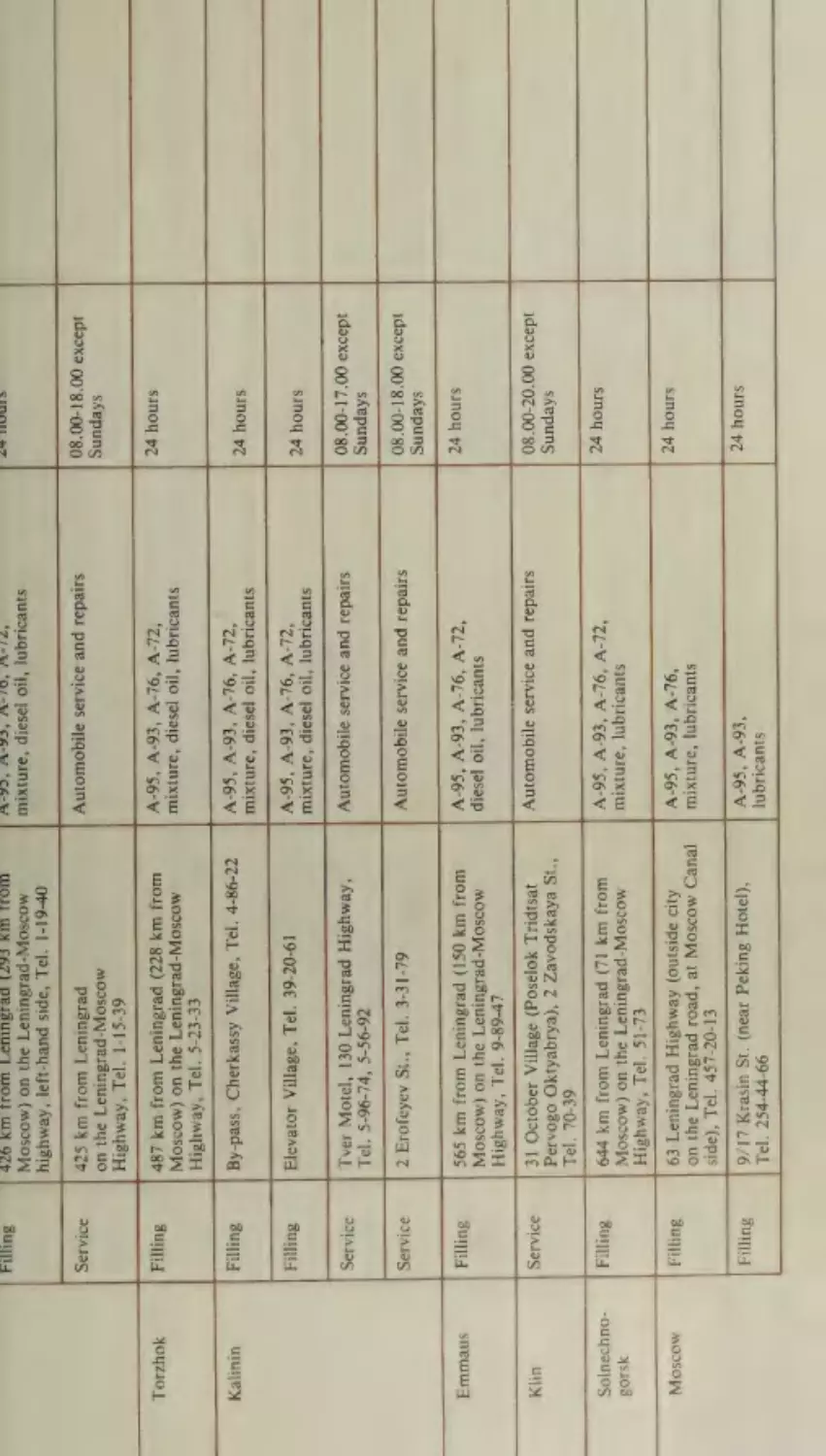
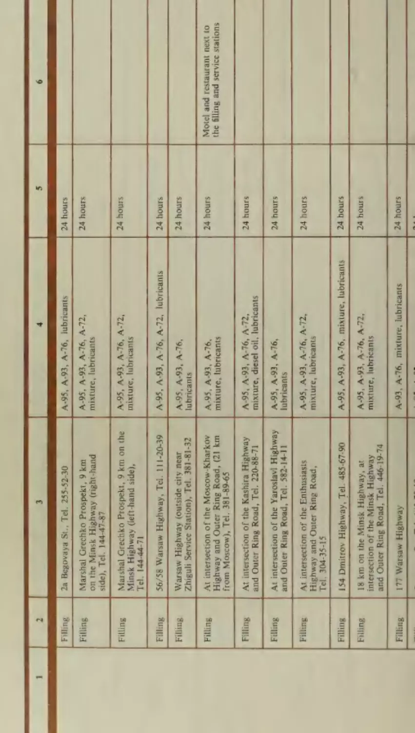
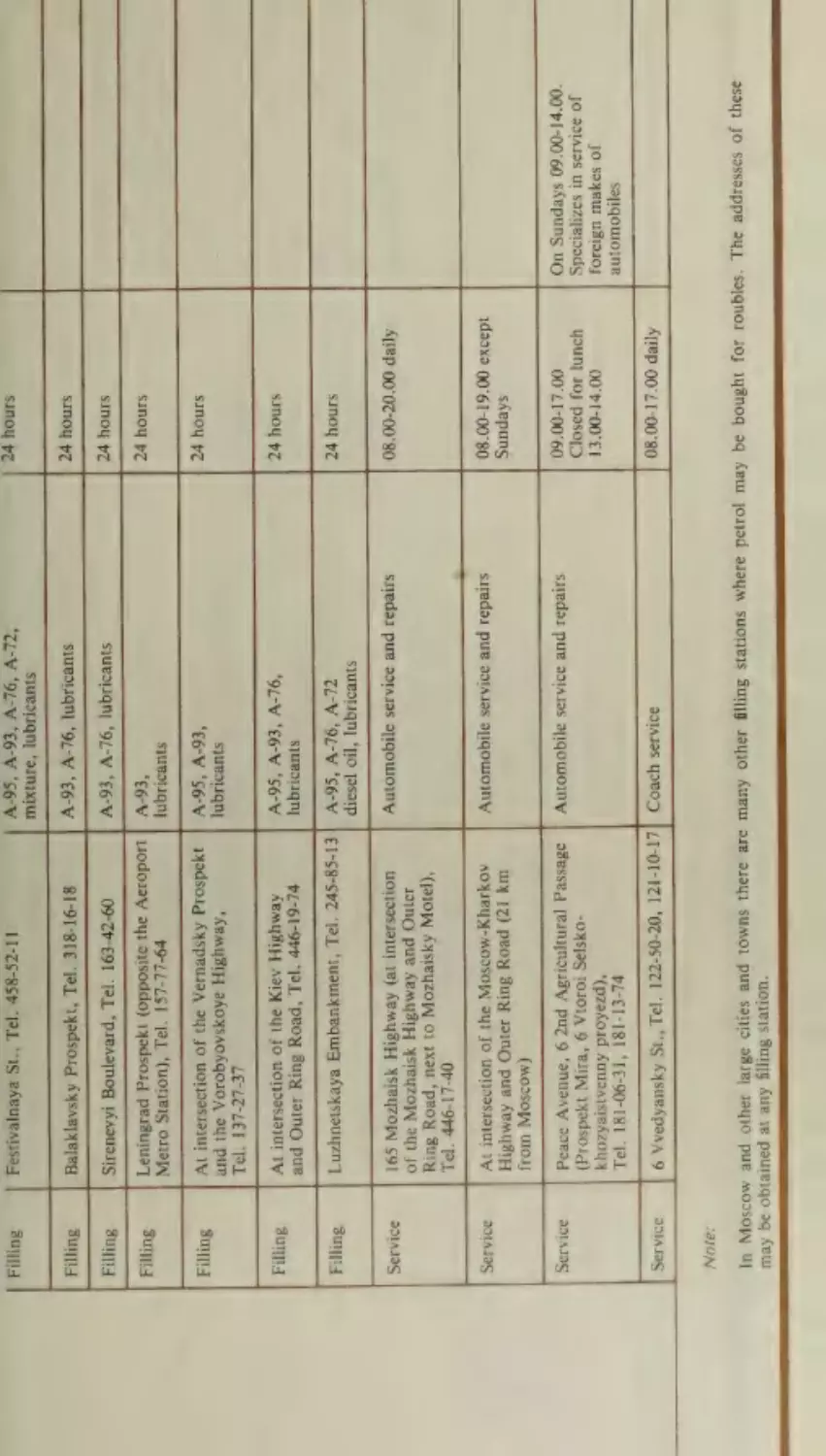
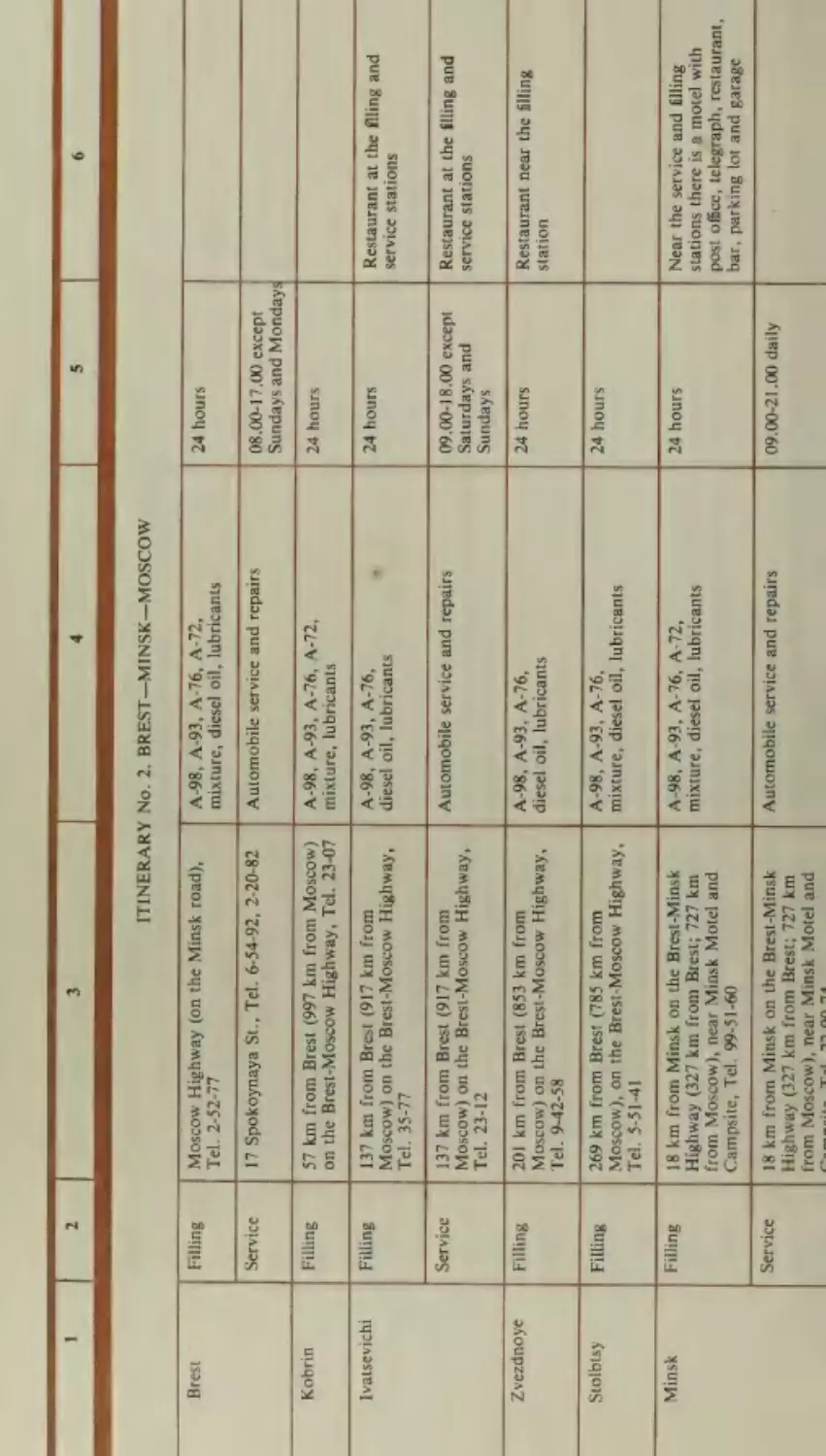
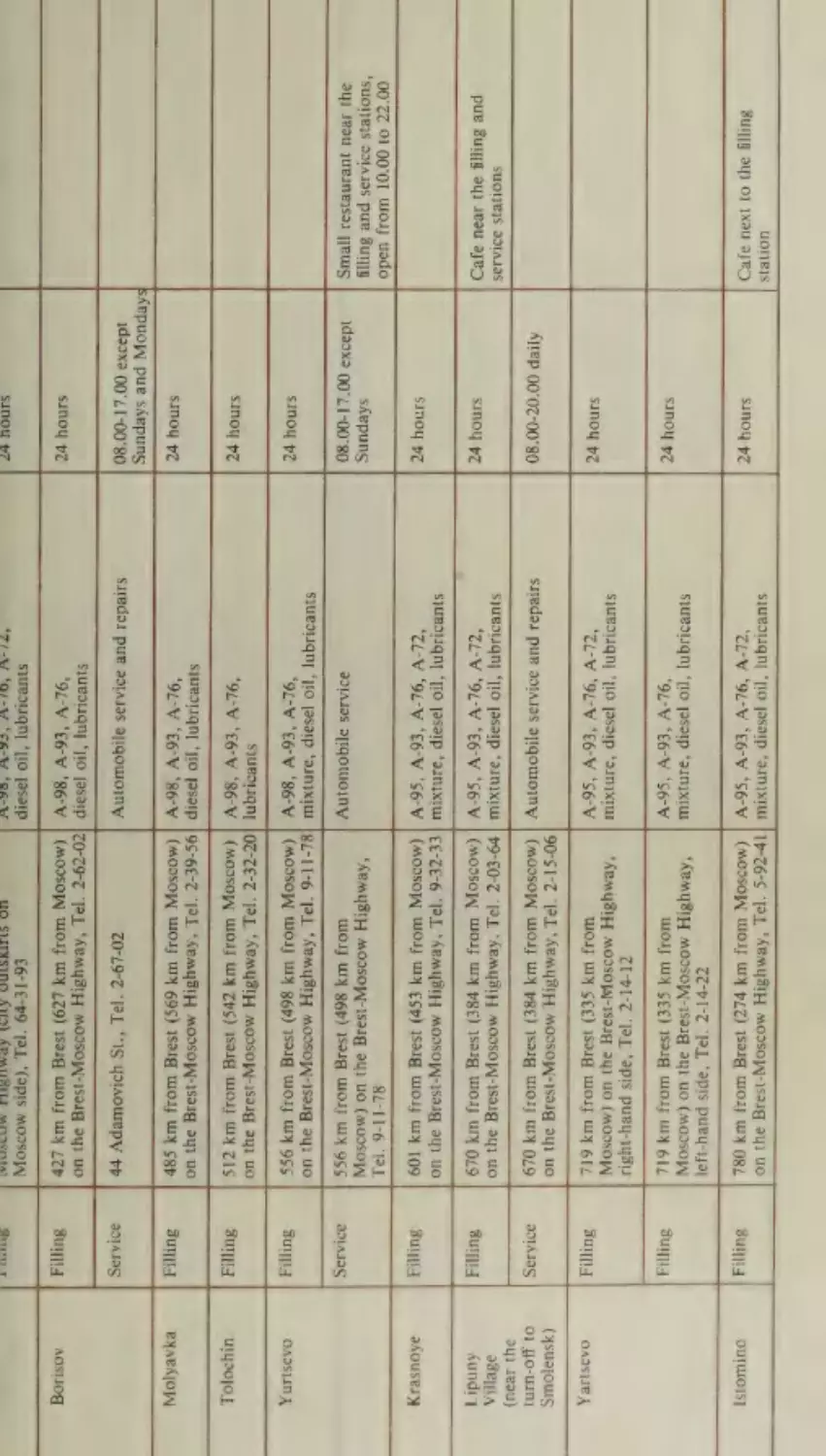
16. List of Recommended Filling and Service Stations
346
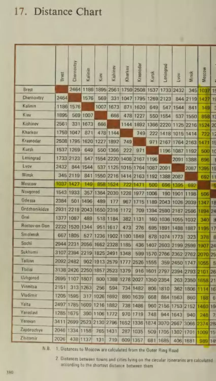
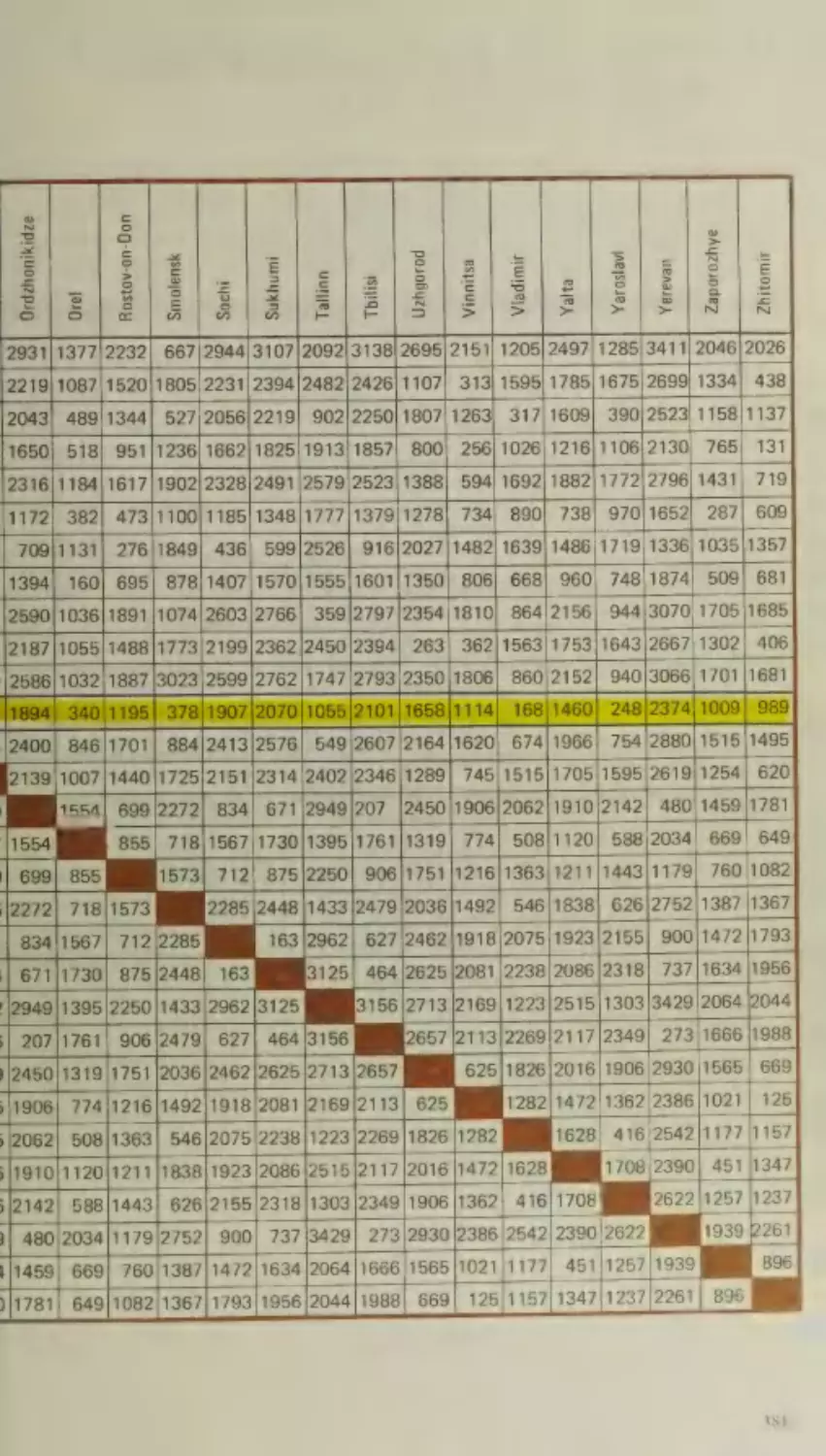
7s Distance Chart
380
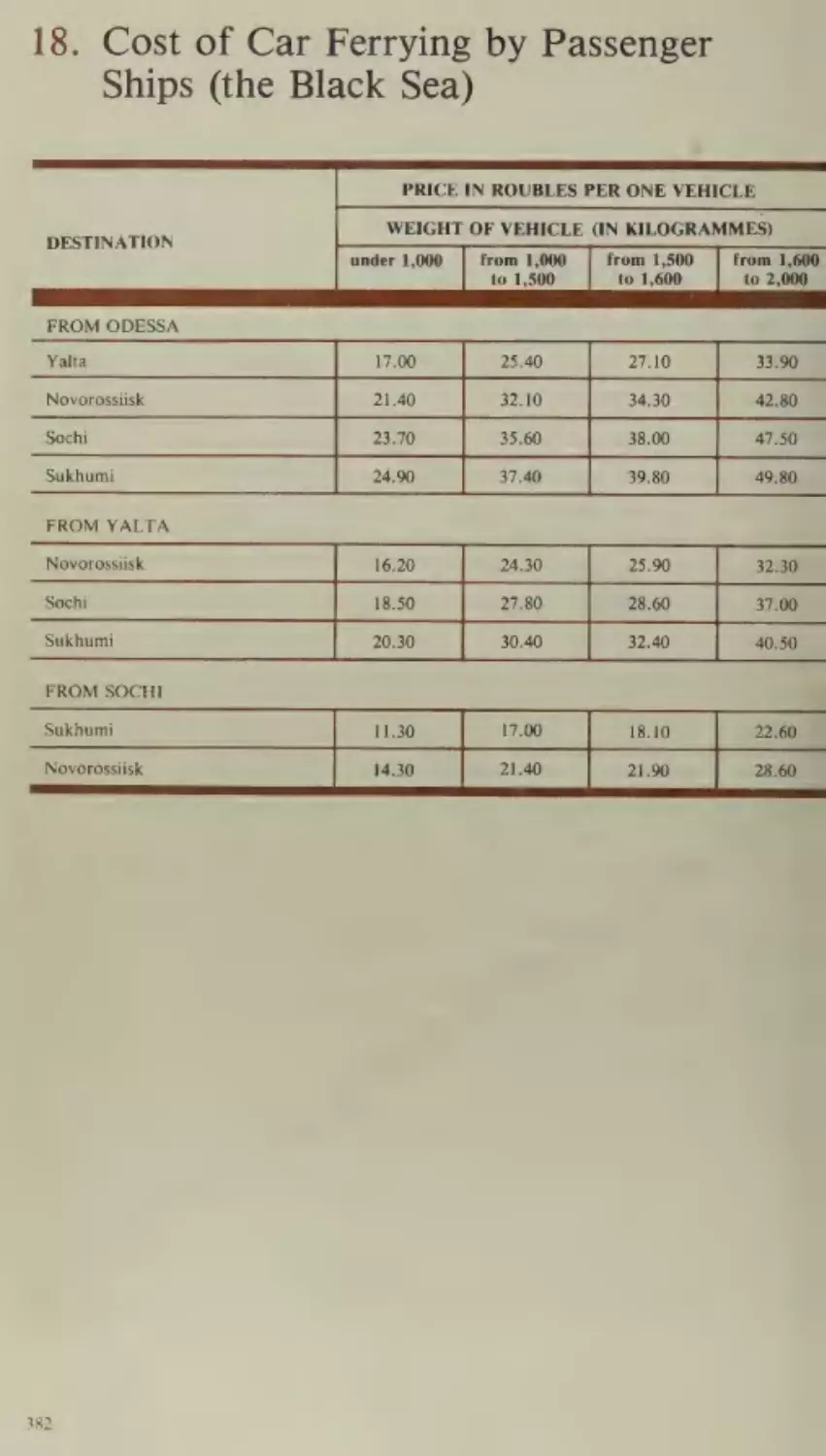
18. Cost of Car Ferrying by Passenger Ships
(the Black Sea)
382
19. Useful Phrases
383
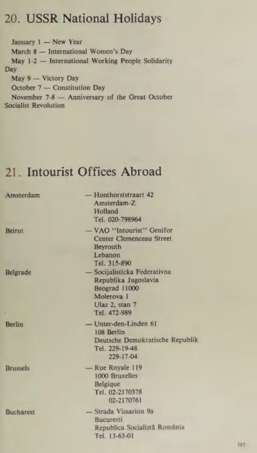
. USSR NationalHolidays
385
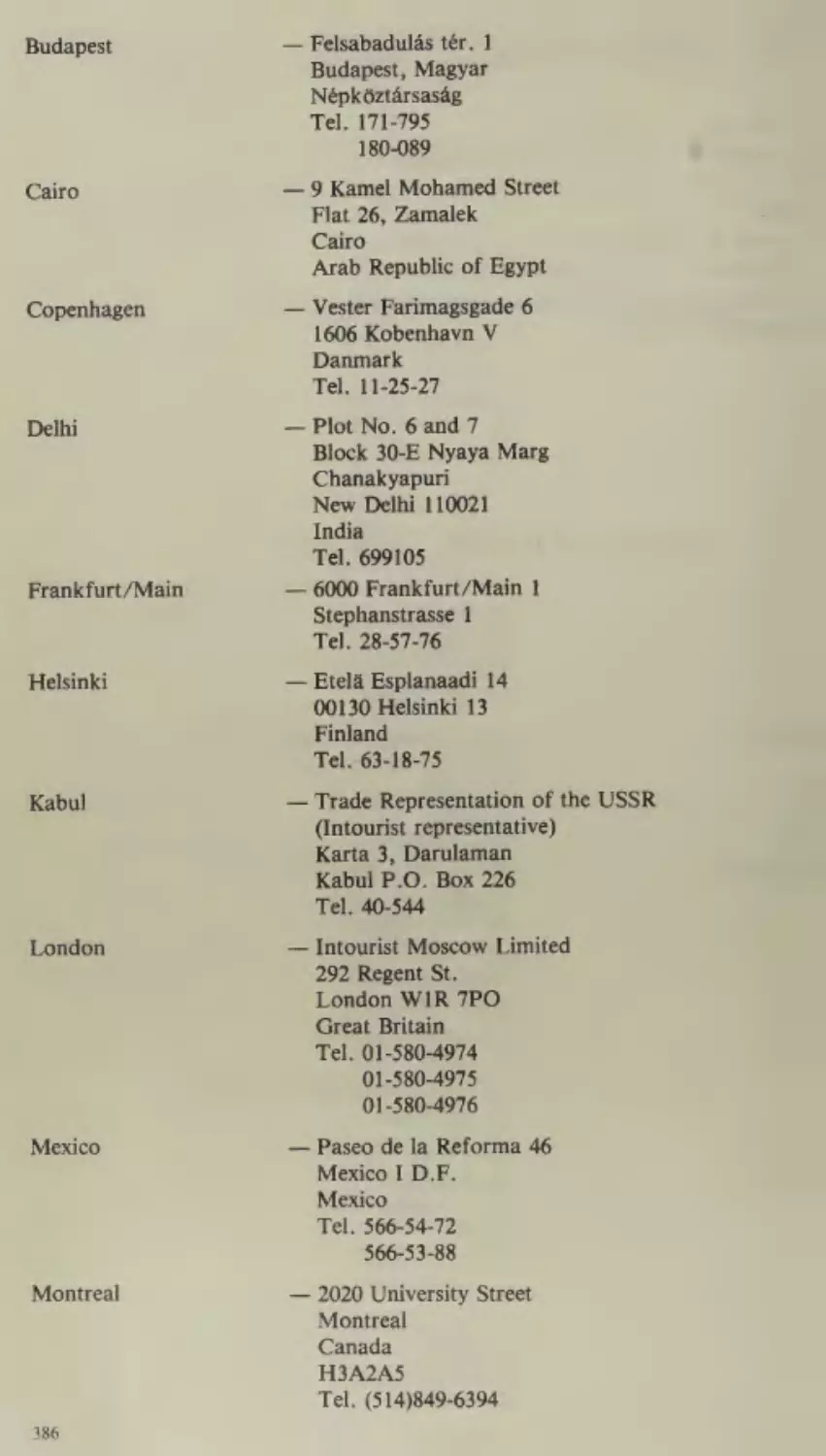
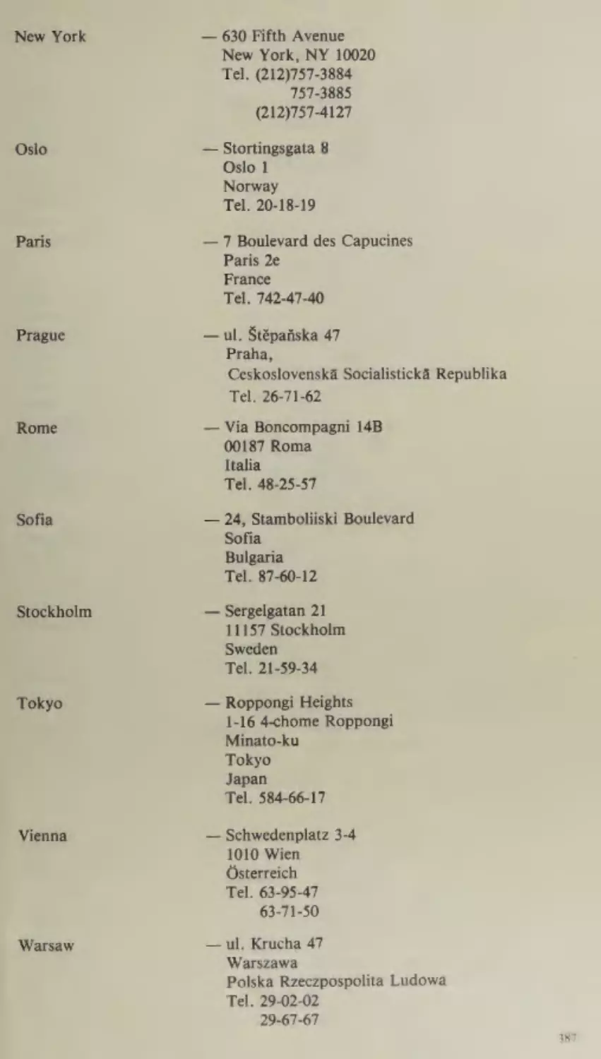
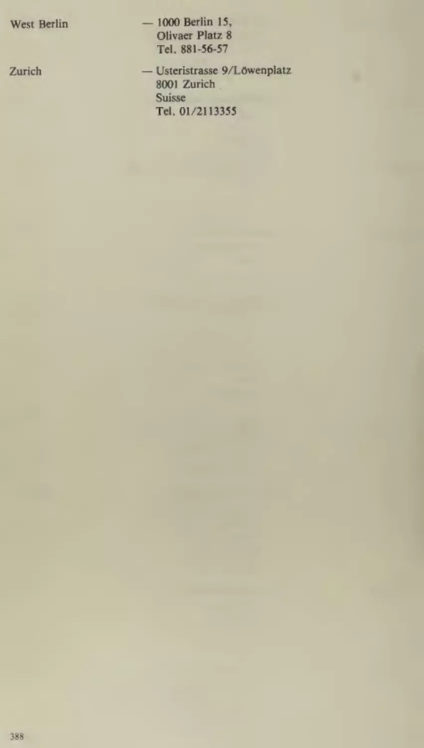
21. Intourist Offices Abroad
385
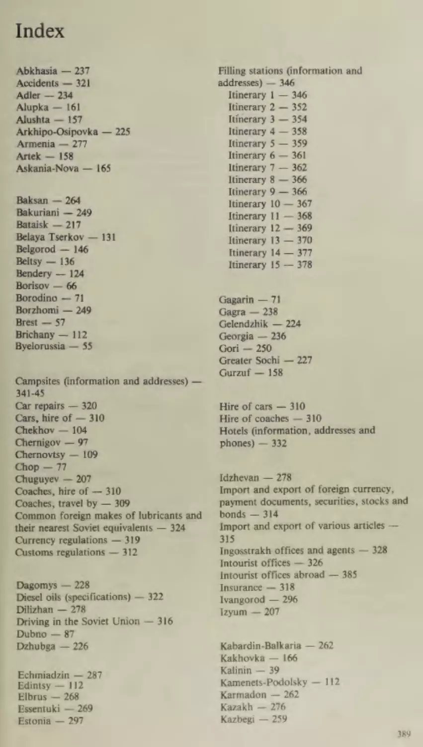
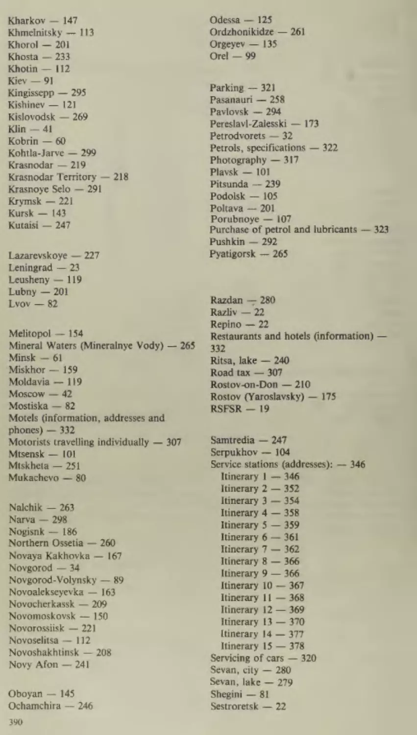
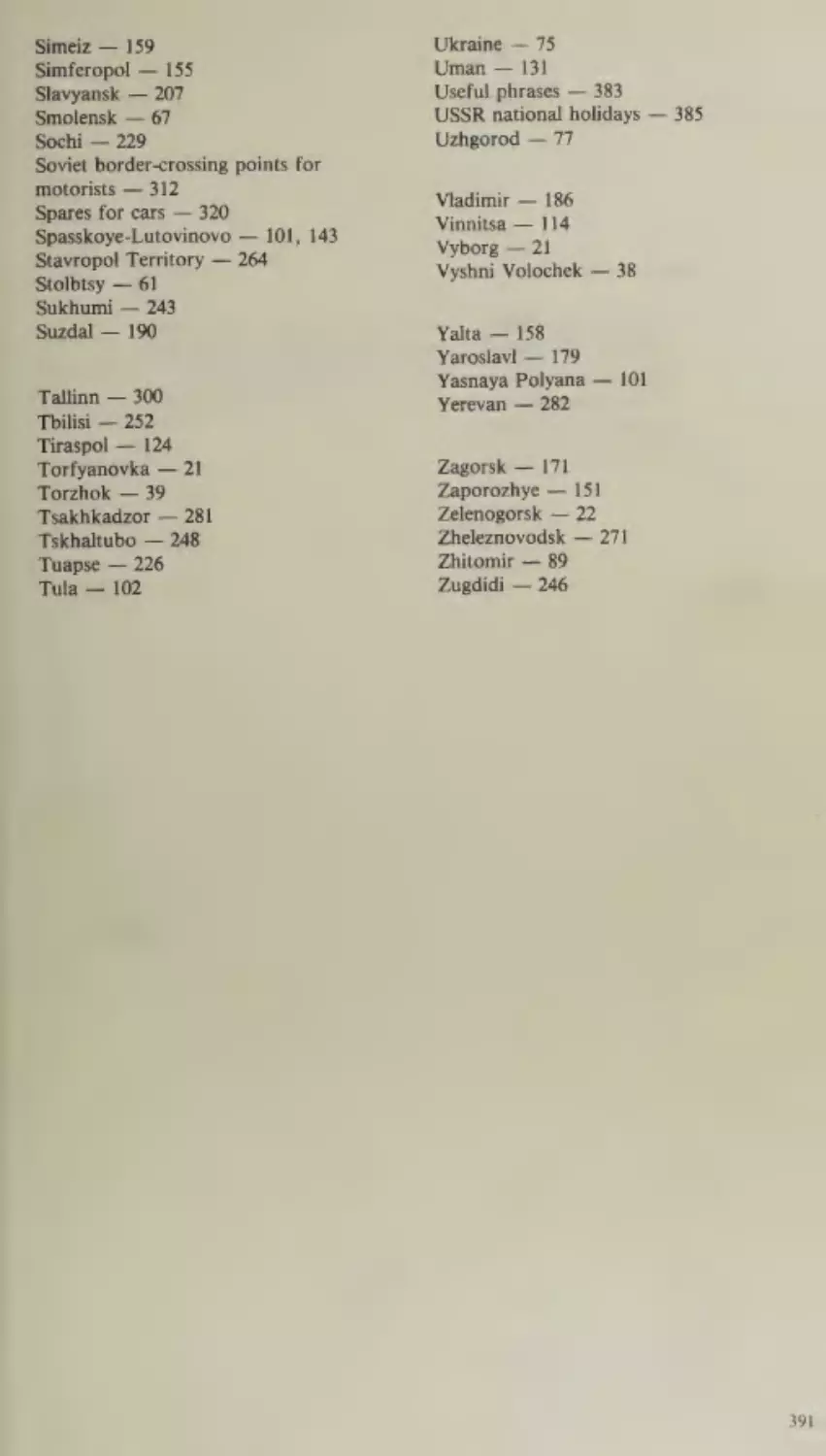
Index
389
.
nha i
a
i
s
nie
-
ir “os icles parctet eee? ‘iisepihsoaiad
OM.
5
Ae. Gatti ata. bid OG Vo encinyl
aa
UH Gna et lo aah)
a
pith
tm
bak
sth
“od an box
1 ralarteangal
Saale
—_
Binh
:
,
i
fo
ee
a
,
ie
wwe
Uitn
\¢ sia]
wed)
:
ag
.
fh).
So
cat ‘See
Ea
=;
“a
;
. \
/ =
;
th
“3
(apna
Pieri
,
—
,
see
,
5.1
Ai
OH heiininnrmeneg Shasromanedinagal ybrp ity, TA. So
as2%
a
=
FMF es, ca
a bie Seervetti
.
ic} 9 hunt A vrs 5
anne
.
peered Morey
Oak, Beebe: Peest
Ae
Phy
F
=“ae
el
eps
wort) ta
:
bee — 554
F
:
aes
-
eee’
dey em
ed
yd
lore) to eerie’ ine
:
;
a
AGVICE AND Ih
PeweiiaT iar
wil) Om Goteag emo, bine alptpl, tyo Soar"
oe:
%
pales ‘} RoiGeie
Sicaiaviggt rorvp*
Att
'
bo
SrA Oi ni tril)
‘a
Introduction
There is no finer way than a motoring holiday to see a
country, find out about the life of its people and learn about its
achievements. Travelling by car or coach you can see more, and
experience more than you could by any other means of
transport. Furthermore, on a motoring holiday you can go ona
fairly long journey at a comparatively reasonable cost.
Consequently more and more tourists coming to the Soviet
Union prefer to travel by car or coach.
In the Soviet Union we look upon tourism as a means of
broadening and strengthening friendly contacts between
peoples. It is thus supported by the Soviet Government as a
form of cultural exchange and cooperation between countries.
The Peace Programme advanced by the Communist Party of
the Soviet Union and the signing of the Final Act of the Conference on Security and Cooperation in Europe in August 1975
have created a favourable atmosphere for the development of
peaceful cooperation between states with different social
systems. This cooperation is envisaged to cover such fields as
economics, science, culture, information and tourism.
The development of foreign tourism in the USSR means that
the Soviet Union has become a member of a number of international conventions and that its cooperation with other countries
both within the framework of various international organizations and on a bilateral basis has strengthened significantly.
Furthermore, considerable simplifications have been introduced into the visa formalities for foreign tourists. Bilateral
agreements with Czechoslovakia, Poland, the GDR, the Democratic People’s Republic of Korea, Bulgaria, Hungary,
Romania, Vietnam, Mongolia and a number of other countries
have meant that Soviet visas are no longer required for tourists
from these countries. Customs and immigration formalities
have also been considerably simplified in recent years.
Tourists coming to the USSR have the opportunity of gaining
first-hand knowledge of the past and present of one of the
greatest countries in the world — a country where just sixty
years ago the soil was ploughed with wooden plough-shares and
the majority of the population were illiterate, a country which
today is building the largest hydro-electric power stations in the
world and engaged in space exploration. Tourists can visit
museums which have some of the finest collections in the world,
look at historical and architectural monuments, stay at
attractive holiday resorts and admire the varied beauty of the
countryside. Many tourists are interested in science, technology, culture, the health services, education, and other aspects
of Soviet social and cultural life. For these the Soviet people are
always ready to answer their questions so that they can have a
better understanding of the country.
Those planning a motoring holiday in the USSR have the
choice of a wide range of itineraries running a total length of 12
thousand kilometres and covering 8 of the USSR’s Union
Republics.
Along these auto-routes there are comfortable hotels, motels
and plenty of service and filling stations. There are also
facilities available for camping which is one of the most
economical ways in which to see a country.
The purpose of the present guide is to acquaint the foreign
tourist with the auto-routes in the Soviet Union and help
answer some of the questions that may arise in connection with
a motoring holiday in the USSR.
Part I of this book is a guide to the 15 main auto-routes,
which are numbered for the sake of convenience. Each itinerary
is accompanied bya brief account of the roads, the towns and
cities on the journey, where overnight stops may be made and
the various forms of accommodation available. The total length
of each itinerary is also given.
Part II gives information on such matters as the Highway
Code in the USSR, immigration and customs formalities,
currency regulations, insurance and photography. It also
lists the addresses and telephone numbers of Intourist
and Ingosstrakh branches throughout the USSR and abroad
as well as giving general particulars on hotels, motels, campsites, filling stations, service stations, and various other useful
information.
;dy
¢ .
i
Ga
2
be.
+4 Sa
Oia
phys
aan
Larne
avddedaby,
Tei
:
2
=F
The Soviet Union
The Union of Soviet Socialist Republics is a socialist state of the
whole people, which was formed on December 30, 1922 on the basis
of the voluntary union of equal Soviet socialist republics. The
USSR now comprises 15 Union Republics. It is the largest country
in the world, occupying 22.4 million square kilometres, or one sixth
of the world’s land area. From east to west the country is more than
10,000 kilometres long and from north to south almost 5,000
kilometres wide. Within the Soviet Union there are 11 time zones.
More than 75 per cent of the country lies in Asia, the remainder in
Europe.
The USSR has borders with 12 different states and its shores are
washed by 12 seas from the basins of the Arctic, Atlantic and
Pacific oceans.
The overall length of its borders is 60,000 kilometres (17,000 km
of land frontier and 43,000 km of coast), which is one and a half
times more than the equator.
The Soviet Union exhibits a wide variety of climate, from the
Arctic regions of the north to the subtropics, deserts and mountain
ranges of the south.
13
The country has tremendous resources of coal, oil, natural gas,
oil shale, iron and manganese, non-ferrous and rare metals, radioactive ores, precious metals, diamonds and numerous non-metallic
minerals.
The Soviet Union has a population of 262 million, which is the
third largest in the world after China and India. Some 163 million,
or 62 per cent, live in the towns.
The Soviet Union is comprised of some 130 different nations and
ethnic groups which have been brought together through their
common historical development and which are working towards
the same end — the building of communism.
The Soviet economic system is based on socialist ownership of
the means of production. The entire property is either state-owned
or belongs to the collective farms and cooperatives. Private
undertakings, however, are permitted, provided they are worked
exclusively by the individual, unaided efforts of the proprietor
himself.
The economic system of the Soviet Union is based on planned
management. It is consequently characterized by high growth rates,
and the absence of slumps, crises and unemployment.
All power in the Soviet Union belongs to the people and is
exercised through the Soviets (Councils) of People’s Deputies. All
organs of state power in the USSR, both central and local, are
elective, and deputies are elected on the basis of universal, equal
and direct suffrage by secret ballot.
The highest organ of state power in the Soviet Union is the
Supreme Soviet of the USSR, which is elected for a period of five
years. It consists of two chambers — the Soviet of the Union and
the Soviet of Nationalities — which have equal rights. The Supreme
Soviet of the USSR elects the Presidium of the Supreme Soviet of
the USSR and the Supreme Court of the USSR, forms the Council
of Ministers of the USSR and appoints the Procurator-General of
the USSR. All these organs and offices are subordinate to the
Supreme Soviet and accountable to it.
The highest executive and administrative organ of state power in
the Soviet Union is the Council of Ministers of the USSR.
The leading and guiding force of Soviet society and the nucleus
of its political system is the Communist Party of the Soviet Union.
At its congresses the CPSU decides the most important questions
affecting Soviet society and sets the guidelines for the future
building of communism.
14
According to the Constitution of the USSR all citizens of the
Soviet Union, irrespective of nationality, race or religion have
equal rights in all fields of economic, political, social and cultural
life.
The Constitution of the USSR guarantees all citizens of the
Soviet Union the right to work, the right to rest and leisure, the
right to health protection, the right to maintenance in old age, the
right to housing, the right to education, the right to enjoy cultural
benefits, the right to associate in public organizations, the right to
elect and the right to be elected. Citizens of the Soviet Union are
also guaranteed freedom of speech, of the press, of assembly,
meetings, street processions and demonstrations as well as inviolability of person and home and privacy of correspondence.
In the comparatively short space of time that has elapsed since
the Great October Socialist Revolution the Soviet people have made
tremendous progress, turning their country from an economic and
cultural backwater into an advanced, modern state with a highly
developed industry and agriculture and a high all-round level of
general culture. ©
During the years of Soviet power national income and industrial
output have risen several dozen times with the result that the USSR,
whose population comprises only 7 per cent of the population of
the whole world, now produces more than 20 per cent of world
industrial output. Radical transformations have taken place in
agriculture. Instead of scattered, small undertakings there are now
huge mechanized cooperative farms (both collective and stateowned). Today the Soviet Union mines more coal and iron ore,
manufactures more tractors, diesels, electric engines, and produces
more coke, pig iron, cement, timber, wool, cotton, sugar, butter,
milk and many other products than any other country in the
world.
The Soviet Union has also made great advances in the peaceful
use of atomic energy, and in space exploration. The Soviet Union
was the first country in the world to build atomic power stations
and atomic ice-breakers and it was Soviet cosmonauts who made
the world’s first space flight and first walked out into space.
But it should not be forgotten in assessing the tremendous
achievements of the Soviet people that 20 of the 60 years since the
Revolution had been spent in both fighting wars that had been
unleashed on the country and in rebuilding after the devastation
MAHELGN
During the Second World War, which is called by the Soviet
people the Great Patriotic War, the Soviet Union suffered greater
than any other country in the world. More than 20 million people
were killed and over 70 thousand towns and villages were destroyed
and burned.
The Great Patriotic War ended with the Soviet Union’s complete
victory over fascism. The country had defended its social gains, its
freedom and its independence and at the same time brought the
peoples of Europe liberation from fascism.
In firmly and unswervingly pursuing a policy of strengthening
peace and cooperation between peoples, the Soviet Union is
endeavouring to implement the Final Act of the European Conference at Helsinki, which was signed in 1975.
As well as the tremendous efforts put into economic
development,
the Soviet
Government
also invests
considerable
resources in education and the health services. Education at all
levels in the USSR is free, and today the number of those engaged
in one form of study or another amounts to some 90 million, or one
third of the entire population. The health services are also free.
Furthermore, tens of billions of roubles are assigned annually to
providing old-age pensions, student grants, and sickness benefits.
The Soviet people have also made considerable advances in
science and culture.
The Soviet Union has the largest number both in absolute and
relative terms (per 10,000 of the population) of qualified engineers,
doctors and students in the world.
More books are printed in the USSR than in any other country in
the world.
One of the most important social gains of the Soviet people has
been the complete emancipation of- women, who now hold full and
equal rights with men. Soviet women participate in the running of
the state and the management of the country’s economy. More than
30 per cent of deputies to the Supreme Soviet of the USSR and the
Supreme Soviets of the Union Republics are women. Furthermore,
women account for 30 per cent of all qualified engineers, 70 per
cent of doctors, more than 35 per cent of lawyers and some 50 per
cent of all students.
Information on the individual Union Republics and economic
regions through which the various routes pass are given under the
appropriate itineraries.
*
AS
& ‘ 4
%
*
~
% $
*
; Bh
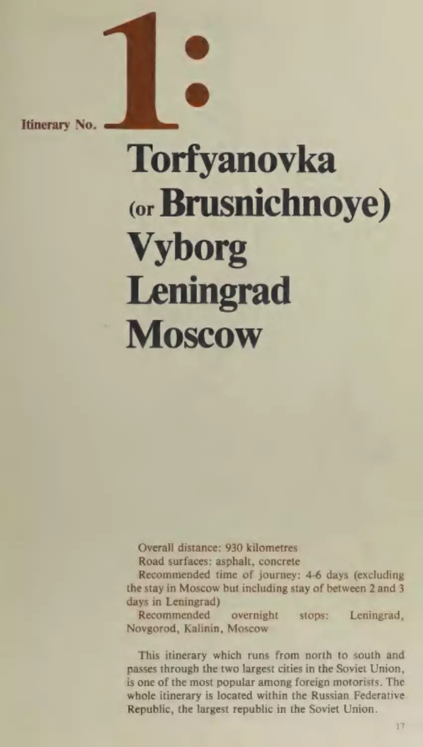
Itinerary No.
Torfyanovka
or Brusnichnoye)
Vyborg
Leningrad
Moscow
Overall distance: 930 kilometres
Road surfaces: asphalt, concrete
Recommended time of journey: 4-6 days (excluding
the stay in Moscow but including stay of between 2 and 3
days in Leningrad)
Recommended
overnight
stops:
Leningrad,
Novgorod, Kalinin, Moscow
This itinerary which runs from north to south and
passes through the two largest cities in the Soviet Union,
is one of the most popular among foreign motorists. The
whole itinerary is located within the Russian Federative
Republic, the largest republic in the Soviet Union.
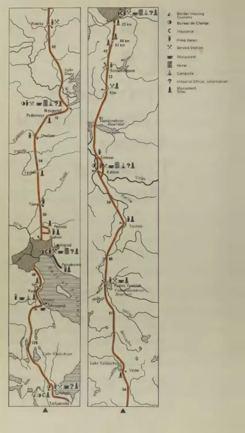
17
Border crossing
Customs
Bureau de Change
Insurance
Filling Station
Service Station
Restaurant
Hotel
Campsite
Intourist Office, information
Monument
Xe
im
>
OO
>
ites
hankouskoye
Reservoir
ba
Torzhok
The Russian Federative Republic
The Russian Soviet Federative Socialist Republic (RSFSR) was formed after
the victory of the Great October Socialist Revolution on November 7 (October
26, Old Style), 1917 and was thus the first Soviet socialist state in the world. The
capital of the Russian Federative Republic and of the Soviet Union as a whole is
the city of Moscow.
The republic occupies an area of more than 17 million square kilometres,
which makes it one and a half times larger than the whole of Europe.
,
The RSFSR stretches from the Pacific Ocean in the east to the shores of the
Baltic Sea in the west and from the icy seas of the Arctic Ocean in the north to the
clear waters of the Black Sea and Caspian Sea in the south.
The republic is divided from north to south by the Urals, a low range of
mountains that separates the European part of the RSFSR from the Asiatic part.
The Russian Federative Republic is rightly looked upon as the older sister in
the family of Soviet republics. It contains 75 per cent of the land area, more than
50 per cent of the population and produces 66 per cent of the industrial and 50
per cent of the agricultural output of the Soviet Union.
The RSFSR has a population of more than 137 million from more than 100
different nationalities though the overwhelming majority are Russians who
comprise more than 83 per cent. There are more than 1,000 large towns in the
republic with a combined population of over 90 million or almost 70 per cent of
its total population.
The Russian Federative Republic is rich in minerals and raw materials. There
are particularly huge reserves of coal, oil, and natural gas. The republic
19
also possesses vast tracts of forest in Siberia, the Far East and the northern
European part which together make up 90 per cent of the Soviet Union’s timber
reserves.
Within the RSFSR there are some 120 thousand rivers including the largest
rivers in the USSR, the Volga, the Ob, the Yenisei, the Lena and the Amur,
which allow the development of hydro-electric energy and river transport.
The years of Soviet power have witnessed great changes in the RSFSR which
now has a strong and thriving economy. In the 35 years alone from 1940 to 1975,
despite the tremendous damage that was done to the national economy by the
war, the growth of industrial output in the republic rose more than 15 times.
Now in terms of output in the key industries, the Russian Federative Republic
leads almost all countries in the world. It produces more electric energy, coal,
gas, mineral fertilizers and fabrics than any other country except the United
States and in the manufacture of steel, rolled steel and cement the RSFSR holds
third place in the world after the United States and Japan.
Before the revolution Siberia and the Far East, which are part of the Russian
Federative Republic, were sparsely populated areas of wasteland (taiga). They
are now important economic regions. In Siberia there are some of the largest
hydro-electric power stations in the world including the Bratsk Power Station
(4.1 million kw) and the Krasnoyarsk Power Station (6 million kw). The power
stations that are being built here will form the base for a thriving industry. Here
too the huge Baikal-Amur Railway — the largest construction project of the late
20th century — is being built from Lake Baikal to Komsomolsk-on-Amur, a
distance of 3,145 kilometres.
On the broad plateau between the Urals and the Volga, in Siberia and in the
northern European part of the RSFSR intensive work is being carried out in
drilling the huge deposits of oil and natural gas. There are vast resources of raw
materials in these regions which provide the basis for the extensive development
of the chemical industry, and it is from here that huge pipelines carry gas and oil
across Europe to Poland, the GDR, Czechoslovakia, Hungary and other
European countries. By 1975 there were throughout the republic some 42,000
kilometres of gas and oil pipelines.
The Kursk Magnetic Anomaly, lying in the European part of the RSFSR,
contains billions of tons of iron ore, which for many centuries remained
unmined. Now for the first time this ore is being industrially processed.
Many non-ferrous, rare and precious metals such as copper, zinc, tin, molybdenum, gold, platinum, silver, as well as diamonds, potassium salts, apatite,
mica, bauxite, and building materials, are now being mined in the republic for
the first time.
Agriculture has also shown marked growth rates during the Soviet period.
From 1940 to 1974 the gross agricultural output of the Russian Federative
Republic rose 140 per cent (farming — 90 per cent, stock-breeding — 250 per
cent).
The republic has also made great strides in the sciences, culture and the
provision of medical care. The law makes it obligatory for everyone to receive
secondary education and there are some 25 million pupils currently attending
schools. In the 484 higher and 2,500 secondary specialized educational establishments there are some 5.5 million students, which is 45 times more than in 1915
and 5 times more than in 1940.
The medical services employ a total staff of some two million.
The achievements of the Russian people in the world of culture and the arts are
known throughout the world.
20
Main Auto-Routes
Assuming that you are leaving Helsinki and want to
make Leningrad on the first day, you are well advised to
start out early in the morning. Then you can be fairly
sure of reaching Vyborg by midday and Leningrad by
late afternoon with enough of the evening free for a stroll
around the city.
There are two border-crossing points at the Soviet
frontier on the road from Helsinki to Vyborg—Torfyanovka and Brusnichnoye.
Immigration and customs formalities should not take
long. After these you can change your currency, take out
insurance and receive the various documents you require
as a tourist, either at the border-crossing point itself or at
the Intourist offices in Vyborg (located at the Central
Railway Station).
The road from the border to Leningrad passes through
the Karelian Isthmus which is one of the most picturesque regions in the north-west of the RSFSR. The heady
resinous aroma of the pines, the gentle sea breezes along
the coast, the golden sands on the beaches, the pink
heather, the huge boulders and the innumerable lakes,
streams and small rivers make this a unique landscape
full of its own stark beauty.
The Karelian Isthmus has long been inhabited, and the
ancient settlements found here date back to the 3rd-4th
millennium B.C.
From the 13th century on the Karelian Isthmus was the
scene of many bloody battles. Today things have changed
and the area is now a holiday resort, a place of peace and
a practical example of the good will and friendly
relations that exist between the Soviet Union and Finland.
Vyborg
The first kilometres flash by and you are soon in the
harbour town of Vyborg. Vyborg traces its history back
at least to 1293 when it grew up around the Swedish
castle that was then built here to replace an 12th-century
Russian trading settlement. In 1710 during the Northern
War (1700-21) Vyborg was taken by Russian troops
under the command of Peter the Great. Two hundred
years later this victory was commemorated by a monument to Peter the Great (by Bernstamm) which was
erected on the spot where the Russian troops had their
command post.
“
21
Main Auto-Routes
The canal you see at Vyborg is the.Saimen Canal,
the Soviet section of which has been leased to
Finland, according to an agreement between the two
countries.
There are several ancient architectural monuments at
Vyborg including the Swedish Castle (13th century), the
Annenkron Fortifications (1740) and a number of towers
— the Round Tower, the Clock Tower and the TownHall Tower (15th-17th centuries).
One hundred and four kilometres from Vyborg the
road runs along the shores of the Gulf of Finland and
passes through the resort town of Zelenogorsk. From
here to Leningrad the road runs along the coast past
boarding houses, sanatoria, holiday camps and beaches.
Considerable work is going on here to develop the area as
a holiday resort with new sanatoria, hotels, motels and
campsites being built. It is envisaged that the resort will
be able to accommodate up to 600,000 tourists and holidaymakers a year.
Fourteen kilometres from Zelenogorsk is the village
of Repino (44 kilometres from Leningrad). Here is the
Museum-Estate of the great Russian painter Ilya Repin,
the famous Penates where he spent thirty years from
1900 to 1930 and created some of his finest works. The
Leningrad campsite is located here.
In the early 1900s the village of Kuokkala, as Repino
was then named, was frequently visited by Lenin, and
during the First Russian
Revolution
(1905-07),
the founder of the Communist Party of the Soviet
Union and the Soviet State lived here for a fairly long
period.
Further along the road, some 35 kilometres from the .
centre of Leningrad, is the resort town of Sestroretsk,
which lies a little off the main highway. Just beyond the
town is a place called Razliv, where in July 1917 Lenin
went into hiding from the bourgeois Provisional Government. Five kilometres from the highway, on the shore of
Lake Razliv a granite jetty has been built to mark the
spot where Lenin came ashore. A little further away
from the shore is the hut where Lenin lived for almost a
month and where he worked on his book The State and
Revolution. On this spot today stands a monument in the
form of a plain hut which like the granite jetty is the
work of A. Gheghello, as well as a memorial pavilion,
which contains the papers and utensils which Lenin used
during his stay here.
22
Main Auto-Routes
A few kilometres further on from the turning to Razliv
and you can see the golden spires of the Peter and Paul
Fortress and the outlines of the magnificent buildings of
Leningrad.
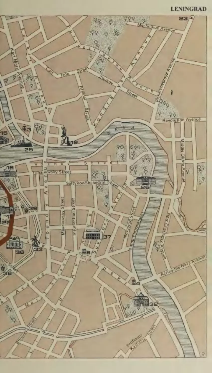
LENINGRAD
Leningrad is the cradle of the Great October Socialist
Revolution and is the second largest city in the USSR,
with a population of 4,588,000 and an area of 606 square
kilometres.
Leningrad is a major industrial and cultural centre, a
large Baltic Sea port and an important transport junction.
The city is located on both banks of the River Neva at
the point where it enters the Gulf of Finland. Leningrad
is a city of islands (some 44 in all) formed in the delta of
the Neva, which besides its main channels runs through
the city in dozens of tributaries, branches and canals.
Altogether in Leningrad there are 60 rivers and canals
whose combined length amounts to some 150 kilometres.
There are 376 bridges in the city, 21 of which can be
opened to allow the passage of shipping.
View over Palace Square and the Winter Palace, Leningrad
hs
|
ans |
=
v@
rag
|}
sj
:
EE
ar
a
ven
|
at cS A
0
S
venue
1S
TaTAk
it EA
perys
yorov
Yl
A AF
LENINGRAD
S|
\
O's
ray
wea
oe
EI
:
S \I
\\\\
Street
kovsky
u
°
9
ry.
a
{/
e
©
g
=
ba
c
f23|
ata
Bar
(OSS
Main Auto-Routes
1 Astoria Hotel*
2 Evropeiskaya Hotel*
3 Leningrad Hotel*
22 Monument to Alexander
Pushkin
23 Piskarev Cemetery. Mass
4 Moskva Hotel*
graves of the heroic
5 Pribaltiyskaya Hotel*
defenders of Leningrad
6 Sovietskaya Hotel
7 Rossiya Hotel
24 Field of Mars.
Monument to Those
8 Oktyabrskaya Hotel
Who Fought for the
9 Leningrad Branch of the
Revolution
Lenin Museum
10 Museum of the Great
25 Cruiser Aurora
26 The Smolny Institute
October Socialist
27 The Admiralty
Revolution
28 The Former Senate and
11 Hermitage
12 Russian Museum
13 St. Isaac’s Cathedral
14\ Peter and Paul Fortress
15 Peter the Great’s HouseMuseum
16 Peter the Great’s Palace-
Synod
29 The Moscow Triumphal
Gates
30 Rostral Columns and
Embankment
3 — Palace Square including
the Winter Palace, the
Museum. Summer
Alexander Column and
Gardens and Monument
the General Staff
to Ivan Krylov
17 Museum of the History
Headquarters buildings
32 Alexander Nevsky Lavra
of Religion and Atheism
(Monastery) and the
(Kazansky Cathedral).
Museum of Urban
Monuments to Kutuzov
and Barclay de Tolly
18 Peter the Great Museum
of Anthropology and
Sculpture
33 Anichkov Bridge
34 Kirov Academic Theatre
of Opera and Ballet
Ethnology (formerly
35 Maly Opera House
Kunstkammer)
36 Pushkin Academic
19 Monument to V. I. Lenin
20 Monument to Peter the
Great (the Bronze
Horseman)
21 Monument to Alexander
Suvorov
Drama Theatre
37 Oktyabrsky Concert Hall
_ 38 Gorky Academic Drama
Theatre
39 Circus
40 Lenin Stadium
Main Auto-Routes
The history of Leningrad (which before 1914 was
called St. Petersburg, and from 1914 to 1924, Petrograd)
is quite unlike that of any other Russian town.
The city itself was the result of the economic and
political development of Russia’s land empire, which
needed an outlet to the Baltic Sea.
It was founded by Peter the Great in 1703 on the
marshy banks of the River Neva and built according to a
single plan as a future capital city. Thousands of serfs
were brought to work in insufferable conditions building
the many palaces, mansions, warfs, gun-powder and
brick factories. The low, clay banks of the Neva, the
changeable climate and the frequent flooding made
conditions highly dangerous and many workers perished,
but it was nevertheless built with remarkable speed. A
decree of Peter the Great banning the building of stone
houses in any other part of the country meant that stonemasons from all over Russia came to work at St. Peters-
burg.
With the building of the city Russia received the
‘‘window on Europe’’ it so badly needed and with it the
opportunity to build up foreign trade, so that Russia
soon became a major naval power. The first trading ship
arrived in St. Petersburg in 1703 and by 1726 the city was
already accounting for 90 per cent of the country’s
foreign trade.
During the late 18th century factories began to be built
at St. Petersburg, but it was not until 100 years later
following the abolition of serfdom that industrial
development really began to get underway. The building
of railways, the building of the Mariinsky and Tikhvinsky networks of canals and the introduction of steam
engines in industry and transport meant the rapid growth
of industry in St. Petersburg, particularly iron-and-steel
and engineering.
At the same time St. Petersburg was developing into a
major cultural and scientific centre. The Academy of
Sciences which was founded in 1725 marked the debut of
Russian science on the world arena. During the early
18th century the Naval Academy, Engineering and
Artillery Schools, and medical institutes were also
founded, and later a university and mining, forestry,
technological and engineering institutes.
Many famous Russians from the world of science and
culture are connected with the city. St. Petersburg, for
example, saw the flowering of Russian music, opera and
27
Main Auto-Routes
ballet, and such composers as Glinka, Dargomyzhsky,
Rimsky-Korsakov, Musorgsky, Tchaikovsky, Borodin
and Shostakovitch lived and worked here. Then
again, many great writers, poets and artists like
Pushkin, Lermontov, Nekrasov, Gogol, Turgenev,
Dostoevsky, Gorky, Bryullov, Fedotov, Kramskoi and
Repin created their best-known works here in St.
Petersburg.
The history of the city is also closely linked with
the development of the revolutionary movement in
Russia. In December 1825 an armed uprising took place
against tsarism and serfdom, which was organized by
members of the progressive nobility, who have gone
down in history under the name of the Decembrists. This
insurrection was brutally put down by the forces of
autocracy.
By the turn of the century St. Petersburg had become
the leading centre of the revolutionary movement. The
city played a decisive role in the February Revolution of
1917, which overthrew tsarist autocracy and later during
the Great October Socialist Revolution, which laid the
foundations for the building of the world’s first socialist
state.
During the Great Patriotic War (1941-45) the city of
Leningrad underwent terrible sufferings. The whole
population took part in the heroic defence of the city,
which was blockaded from all sides. Despite the
deprivations, the lack of food and the continued
bombing and artillery fire, the defenders of the town
steadfastly repulsed the attacks of the enemy, and the
city’s industry never ceased to supply the front with
weapons and ammunition.
For 900 days the heroic defence of Leningrad
continued. More than 650,000 Leningraders died from
hunger, cold or during the bombing. Both within the city
and in its environs priceless historical monuments were
destroyed, as were hundreds of factories. Altogether
3,174 buildings were destroyed completely and 7,143
damaged severely.
In memory of the tremendous sacrifices made by
Leningrad
during
the blockade
large memorial
complexes were built in 1960 and 1965 at the
Piskarevskoye and Serafimovskoye cemeteries, where
those who died defending the city lie buried, and in 1965
the city was awarded the title Hero-City.
Much energy and resources were spent after the war in
28
Main Auto-Routes
rebuilding Leningrad and restoring the beautiful
architectural monuments in and around the city.
Leningrad’s industry was also rebuilt and once more
began to develop at a high rate. Modern machines of all
kinds began to be built including the most powerful
steam and hydraulic turbines in the world, lathes, optical
and electronic instruments. The building here in 1959 of
the world’s first nuclear-powered ice-breaker, the
Lenin, marked the beginning of the Soviet Union’s
atomic ice-breaker fleet.
Today Leningrad is one of the foremost cities in the
Soviet Union in terms of scientific and technical progress.
The social services in the city, too, have received considerable attention. Over the last 20 years a massive
housing programme has been launched. In the ten years
from 1961 to 1970 alone 21.4 million square metres of
housing space were built, providing 40 per cent of the
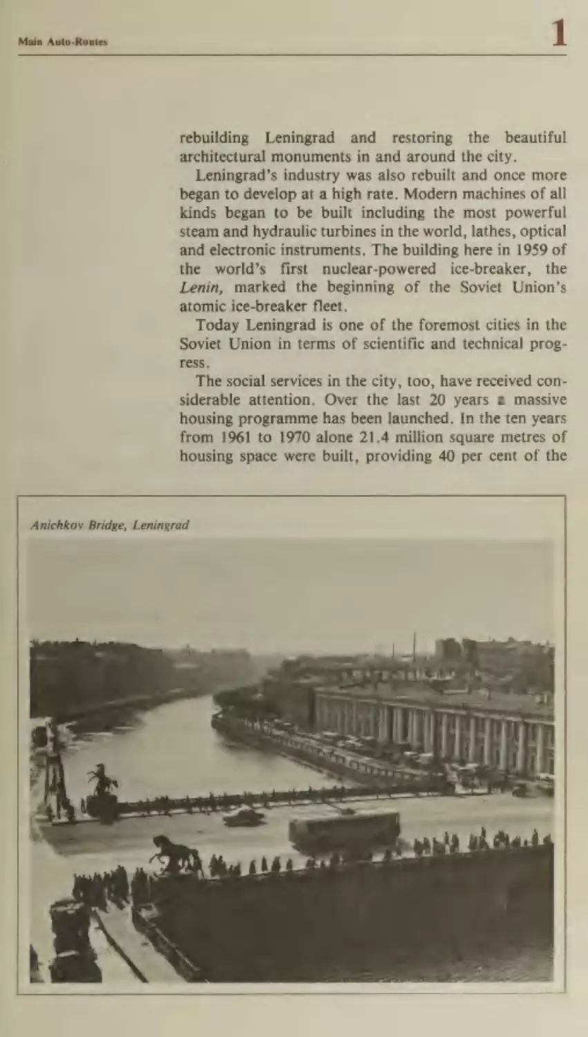
Anichkoy Bridge, Leningrad
Main Auto-Routes
population with new homes. In 1978 the amount of
housing space in the city had doubled as compared with
the figure for 1940. In recent years many hotels, cinemas
and restaurants have been built as well as schools,
kindergartens and hospitals. The building of the
Leningrad metro in 1955 which continues to be extended,
has significantly improved transport services in this vast
city.
Leningrad is now one of the world centres of science
and culture. It has 41 colleges of higher education with
a total of 270 thousand students, 86 secondary specialized educational establishments with 115 thousand
students and more than 300 research and design
institutes.
In Leningrad there are over 20 theatres and concert
halls and some two and a half thousand libraries with a
total of 140 million publications.
Leningrad is one of the most beautiful cities in the
world. Many of its buildings and ensembles are architectural masterpieces. The magnificence of its buildings, the
regular lay-out of the streets, the spacious squares, the
green parks and gardens, the rivers and canals, the beautiful embankments, the ornamental railings and the fine
works of monumental sculpture give the city its unique
and distinctive character. Some of the finest architects
and sculptors of the 18th century like Ivan Starov, Andrei Voronikhin, Carlo Rossi, Bartolomeo Rastrelli,
Domenico Trezzini, Alexander Kokorinov, EtienneMaurice Falconet, Peter Klod, and Stepan Pimenov
designed many of the buildings which you now see in
Leningrad.
There are more than a thousand historical, architectural and sculptural monuments in Leningrad, many of
which are known throughout the world. In 1719 the first
museum in the city — the Kunstkammer — was opened;
today Leningrad has 47 museums.
Of particular interest are the famous collections of the
State Hermitage and Russian Museum, where some of
the finest masterpieces in the world are on display.
There are also many interesting places in Leningrad
connected with the revolutionary events of 1917 and the
life and work of Lenin. These include the building of the
former Smolny Institute, which was the headquarters
of the Bolshevik Party during the revolution; the
Field of Mars — a monument to the revolutionaries;
the cruiser Aurora, which gave the signal for the
30
Main Auto-Routes
beginning of the October
now be seen
others.
by the Neva
Revolution, and which can
embankment,
and
many
The historical centre of the city is Palace Square,
around which stand the beautiful Winter Palace, built
between 1754 and 1762 by B. Rastrelli in the style of
Russian baroque and the two buildings of the General
Staff Headquarters with their monumental arch, built by
C. Rossi in 1829, which take up the square’s southern
side.
In the middle of the square is the Alexander Column,
erected in 1834 by Auguste Ricard de Montferrand, in
memory of the victory of the Russian people in the
Patriotic War of 1812. The column, which weighs 600
metric tonnes and is 47.5 metres in height, was made
from a single block of granite and is held in place by its
own weight alone.
To the west of Palace Square is Decembrists’ Square.
Here stands the imposing Admiralty Building, whose
silhouette has become the emblem of the City of Leningrad.
Leading into Decembrists’ Square is Leningrad’s main
street — Nevsky Prospekt, which runs four and a half
kilometres from the Admiralty Building to Alexander
Nevsky Square. Here stands the Alexander Nevsky Lavra
(Monastery), founded during the reign of Peter the
Great. The monastery includes the Trinity Cathedral
(1776-90), in the style of Russian classicism, and a
number of cemeteries from the 18th, 19th and 20th centuries, where famous figures from Russian science and
culture lie buried. In the Church of the Annunciation
lies the grave of Field Marshal Alexander Suvorov,
a great Russian soldier who lived in the 18th century
and whose monument (erected in 1818 by Mikhail
Kozlovsky) now stands in Suvorov Square near the
Kirov Bridge.
A more detailed description of this remarkable city
would require far more space than is available in this
guide. You are therefore recommended to consult the
guidebooks that exclusively cover Leningrad and its
museums.
However, during your brief stay in the city there
are three excursions to the beautiful palaces and
parks of Petrodvorets, Pavlovsk and Pushkin in the
environs of Leningrad which are well worth making if
time allows.
31
1
Main Auto-Routes
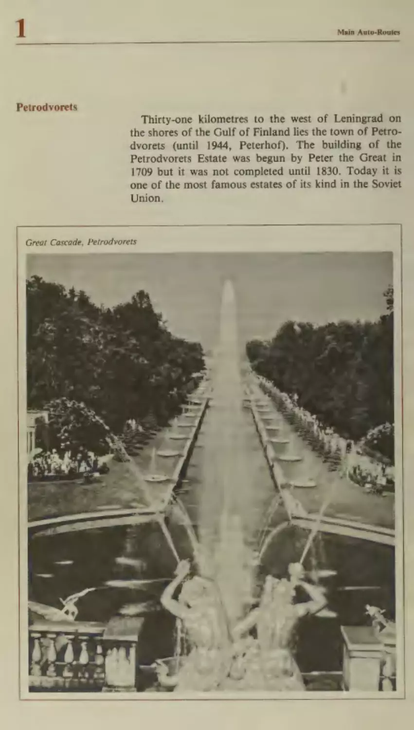
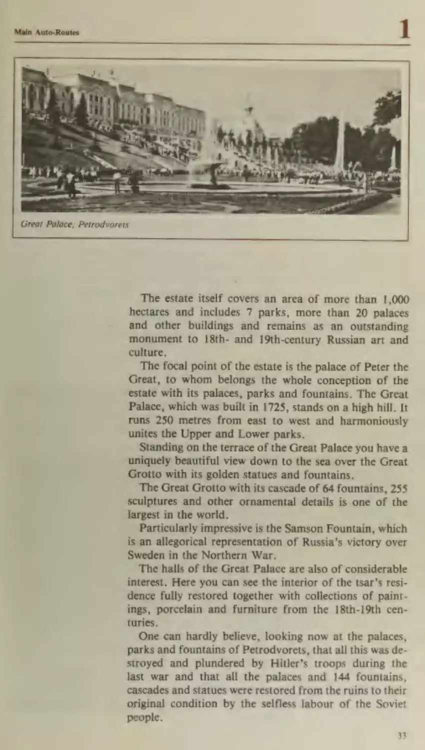
Petrodvorets
Thirty-one kilometres to the west of Leningrad on
the shores of the Gulf of Finland lies the town of Petrodvorets (until 1944, Peterhof). The building of the
Petrodvorets Estate was begun by Peter the Great in
1709 but it was not completed until 1830. Today it is
one of the most famous estates of its kind in the Soviet
Union.
Great Cascade, Petrodvorets
Main Auto-Routes
1
Great Palace, Petrodvorets
-
The estate itself covers an area of more than 1,000
hectares and includes 7 parks, more than 20 palaces
and other buildings and remains as an outstanding
monument to 18th- and 19th-century Russian art and
culture.
The focal point of the estate is the palace of Peter the
Great, to whom belongs the whole conception of the
estate with its palaces, parks and fountains. The Great
Palace, which was built in 1725, stands on a high hill. It
runs 250 metres from east to west and harmoniously
unites the Upper and Lower parks.
Standing on the terrace of the Great Palace you have a
uniquely beautiful view down to the sea over the Great
Grotto with its golden statues and fountains.
The Great Grotto with its cascade of 64 fountains, 255
sculptures and other ornamental details is one of the
largest in the world.
Particularly impressive is the Samson Fountain, which
is an allegorical representation of Russia’s victory over
Sweden in the Northern War.
The halls of the Great Palace are also of considerable
interest. Here you can see the interior of the tsar’s residence fully restored together with collections of paintings, porcelain and furniture from the 18th-19th centuries.
One can hardly believe, looking now at the palaces,
parks and fountains of Petrodvorets, that all this was destroyed and plundered by Hitler’s troops during the
last war and that all the palaces and 144 fountains,
cascades and statues were restored from the ruins to their
original condition by the selfless labour of the Soviet
people.
33
Main Auto-Routes
A brief description of Pushkin and Pavlovsk are given
under Itinerary No. 15, pp. 292-95.
It is usually with a feeling of great regret that tourists
leave Leningrad, often promising to return at the earliest
opportunity so as to see all the things they missed during
their first visit to this beautiful city.
The road from Leningrad to Moscow runs from the
city centre along Moscow Avenue, at the end of which
you come to Victory Square where in 1975 a magnificent
monument was unveiled to the heroic defenders of
the city during the Great Patriotic War. It consists
of a granite obelisk and a large memorial complex
with an underground museum, the Museum of the
Defence of Leningrad, and an eternal flame in honour
of those who fell defending the city during the 900-day
siege.
From Leningrad the road runs 190 kilometres through
small towns and villages to Novgorod.
Novgorod
Novgorod is one of the oldest cities in Russia. Today it
is the administrative centre of the Novgorod Region. It
stands on both banks of the River Volkhov and 6
kilometres from Lake Ilmen. The earliest written record
of the city dates back to 859 A.D.
Novgorod’s exceptionally convenient geographical
position at the crossroads of a number of important
trade routes gave rise to the city’s rapid development as a
centre of trade, handicrafts and culture in the 10th
century. At that time it was the second most important
city of the state of Kievan Rus. From the 12th to the 15th
century it was the capital of the feudal state of Novgorod.
Ancient Novgorod played a major role in the development of Russian national art and culture. The Novgorod
chronicles, which are the earliest sources for the history
of Russia, exerted a considerable influence on the development of historical writing all over Russia, while
Novgorod birch bark, which was used for writing,
promoted the spread of literacy throughout ancient
Rus.
The numerous architectural monuments and examples
of monumental painting at Novgorod show the high
degree of mastery achieved by the city’s painters and
architects.
34
Main Auto-Routes
1
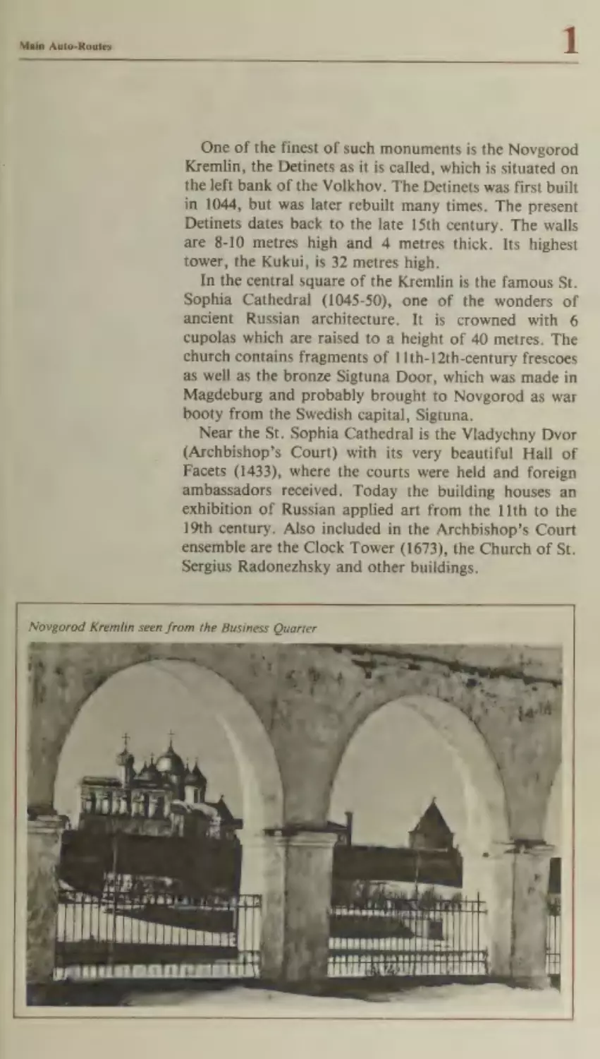
One of the finest of such monuments is the Novgorod
Kremlin, the Detinets as it is called, which is situated on
the left bank of the Volkhov. The Detinets was first built
in 1044, but was later rebuilt many times. The present
Detinets dates back to the late 15th century. The walls
are 8-10 metres high and 4 metres thick. Its highest
tower, the Kukui, is 32 metres high.
In the central square of the Kremlin is the famous St.
Sophia Cathedral (1045-50), one of the wonders of
ancient Russian architecture. It is crowned with 6
cupolas which are raised to a height of 40 metres. The
church contains fragments of 11th-12th-century frescoes
as well as the bronze Sigtuna Door, which was made in
Magdeburg and probably brought to Novgorod as war
booty from the Swedish capital, Sigtuna.
Near the St. Sophia Cathedral is the Vladychny Dvor
(Archbishop’s Court) with its very beautiful Hall of
Facets (1433), where the courts were held and foreign
ambassadors received. Today the building houses an
exhibition of Russian applied art from the 11th to the
19th century. Also included in the Archbishop’s Court
ensemble are the Clock Tower (1673), the Church of St.
Sergius Radonezhsky and other buildings.
Novgorod Kremlin seen from the Business Quarter
CaS
Ty
eT TT) phd
|
ae
pera|
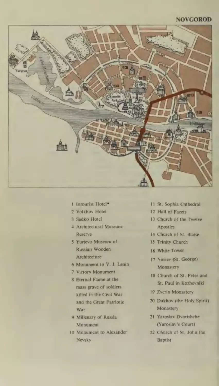
NOVGOROD
Pome
Intourist Hotel*
12 Hall of Facets
Sadko Hotel
13 Church of the Twelve
Architectural
-k
=
WN
an
11 St. Sophia Cathedral
Volkhov Hotel
Museum-
Apostles
Reserve
14 Church of St. Blaise
Yurievo Museum of
15 Trinity Church
Russian Wooden
16 White Tower
Architecture
6 Monument to V. I. Lenin
7 Victory Monument
8 Eternal Flame at the
mass grave of soldiers
killed in the Civil War
and the Great Patriotic
War
9 Millenary of Russia
Monument
10 Monument to Alexander
Nevsky
17 Yuriev (St. George)
Monastery
18 Church of St. Peter and
St. Paul in Kozhevniki
19 Zverin Monastery
20 Dukhovy (the Holy Spirit)
Monastery
21 Yaroslav Dvorishche
(Yaroslav’s Court)
22 Church of St. John the
Baptist
Main Auto-Routes
Also worthy of interest is the St. Sophia’s Bell-Tower
(15th-17th centuries) near the Kremlin wall. The bronze
bells which used to hang in the tower were taken down
during the war and now stand outside the tower. The
largest was cast in 1659 and weighs 36.5 metric tonnes.
In the central square of the Kremlin a monument was
erected in 1862 to celebrate the Millenary of Russia.
Designed by the sculptor Mikhail Mikeshin the bronzecast monument stands 15.5 metres high, weighs around
one hundred metric tonnes and is decorated with 129
sculptures.
In the Pokrovsky Tower (14th century) on the Kremlin
walls, a restaurant, the Detinets, has recently been
opened, which serves Russian national cuisine.
There are many other historical and architectural
monuments in Novgorod outside the Kremlin. These are
found both on the St. Sophia Side, as it is called, of the
Volkhov and on the other side which is known as the
Business District. These include the Church of the
Twelve Apostles (15th century), the Church of St. Blaise
(15th century), the St. Peter and St. Paul Church (12th
century), the Church of St. Simeon (15th century), the
Church of St. Peter and St. Paul in Kozhevniki (15th
century), the Church of St. Demetrius of Thessalonica
(15th century), the Yuriev (St. George) Monastery with
its two churches, the Cathedral of St. George (12th
century) and the Church of the Exaltation of the Cross
(19th century), the churches of the Zverin Monastery
(12th century), the two-tiered Trinity Church of the
Monastery of the Holy Spirit (16th century), the Church
of St. Nicholas in the Yaroslav Dvorishche (Court) and
many others.
There is also a museum-reserve, displaying examples
of wooden architecture from various centuries, which is
also well worth seeing.
During the war many of Novgorod’s valuable architectural monuments as well as almost all the dwelling houses
and administrative buildings were destroyed. After the
war the whole city had to be practically rebuilt.
Today Novgorod has a developed industry and a population of 186,000, which is four and a half times as
much as it was in 1939.
Today the city has three colleges of higher education,
seven secondary specialized educational establishments,
a drama theatre and a number of other cultural and
educational establishments.
37
Main Auto-Routes
Beyond Novgorod the road runs in a south-easterly
direction through the picturesque undulating countryside
of the Valdai Heights to the next major town on the
itinerary — Kalinin.
Eighty-five kilometres from Novgorod is the village of
Kresttsy, which is famous for its embroidery. Here in the
19th century a special style of folk embroidery developed
and today the village has its own factory which produces
shawls, coverlets, serviettes and many other articles
embroidered in the local traditional manner.
One hundred and forty kilometres further on the road
runs through Valdai, the district centre of the Novgorod
Region, which stands on the banks of the deep blue Lake
Valdai amid a huge forest reserve. In the Valdai District
there are more than one hundred lakes, famed for their
pure, clear water.
The earliest mention of Valdai is found in the 15thcentury chronicles, where it is described as a village, but
in 1770 Valdai was made into a town by an edict of
Catherine the Great. In the days when the only means of
communication between Moscow and St. Petersburg was
by horse-drawn transport, Valdai was famed for its
harness and bridle bells. These bells had a distinctive
sound of their own and were known all over Russia.
In the middle of Lake Valdai is Ryabinovy Island,
there stands the 17th-18th-century Iversky Monastery.
There are no major industrial enterprises in Valdai.
The beautiful countryside, the virgin forests and the
numerous lakes have ensured that Valdai will be developed as a holiday resort and tourist attraction, and
already a number of sanatoria and holiday camps have
been built around the town.
ji
After leaving Valdai the road passes through the old
village of Yedrovo, which marks the boundaries of the
Novgorod Region. From here it is 91 kilometres to
Vyshny Volochek.
From the 9th to the 12th century the trade route from
Novgorod to the Volga passed through Vyshny
Volochek. Here at the watershed between the River
Msta, which flows into Lake Ilmen and the River
Tvertsa, a tributary of the Volga there was a portage
(volok) or track over which boats had to be carried from
one waterway to another. Here in 1709 the first canal in
Russia was dug.
Today Vyshny Volochek is a town of 100,000 inhabitants. Its chief industry is textiles. The town now has its
own theatre and a museum of local history.
38
Main Auto-Routes
After Vyshny Volochek the road passes through
Torzhok, another old Russian town. In the 10th-11th
centuries Torzhok was a well-known trading town, famed
for its lace and its embroidery in gold thread on Morocco
leather and velvet. Today this type of handicraft has
been extensively developed and the unique wares of the
town’s craftsmen are frequently displayed at international exhibitions.
Fifty-nine kilometres further on at the confluence of
the Volga, which starts its journey in the Kalinin Region,
and the River Tvertsa, stands Kalinin.
The Tver Motel and Campsite are located at the entrance to the city.
Kalinin
Kalinin, which until 1931 was called Tver, is one of the
oldest towns in Russia. It is now the administrative,
industrial and cultural centre of the Kalinin Region and
has a population of 412,000.
The city was founded in the 12th century by settlers
from Novgorod, and the first reference to it dates back
to 1135 A.D.
From its earliest days Tver featured prominently in the
history of Russia. The Tver Kremlin, which was built on
the left bank of the Volga, was considered a powerful
fortress even as late as the 18th century and was an
outpost on the road to Moscow. Tver was also a major
centre for handicrafts and trade, and the city’s builders,
jewellers, engravers and minters were known far and
wide. The town had trade links with the Baltic, the
Crimea, the Caucasus, the Near East and Central Asia. It
was an inhabitant of Tver, a Russian merchant named
Afanassy Nikitin, who in 1466 — 30 years earlier than
the famous Portuguese explorer Vasco da Gama —
undertook a bold expedition to India.
In the 18th century, the city of Tver which stood on the
main route between Russia’s old capital, Moscow, and
her new capital, St. Petersburg, became a major port on
the Upper Volga. In the 19th century various industries
began to spring up here.
But the Second World War disrupted the peaceful life
of the city. When Kalinin was liberated in 1941, it lay in
ruins. 70 per cent of the city’s factories and 60 per cent of
its housing had been destroyed. After the war the citizens
of Kalinin built up their city in what was an exceedingly
short time so that now Kalinin is once again a major
industrial centre. Today the city has developed light,
39
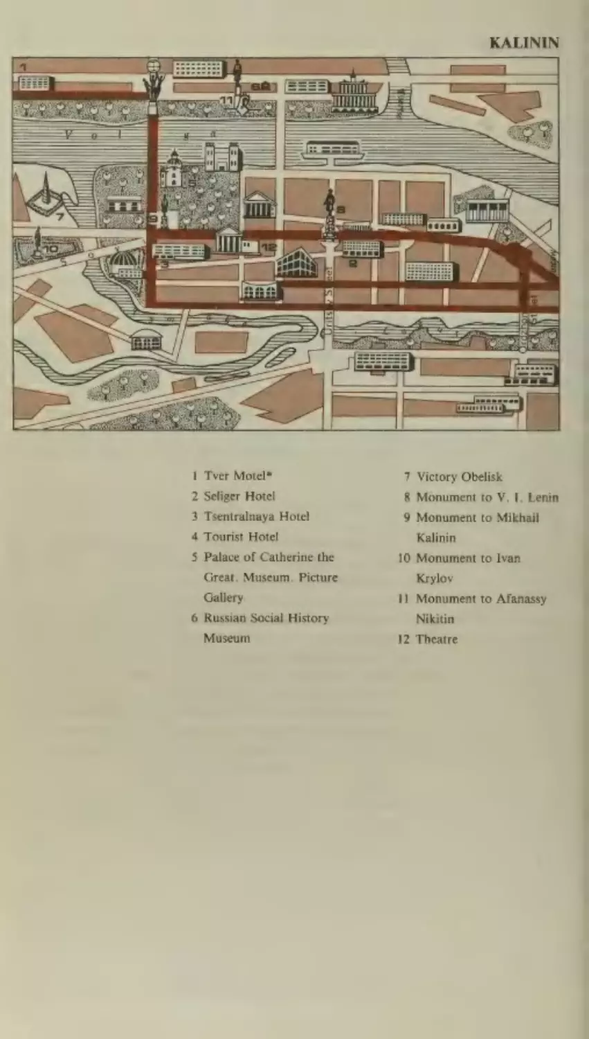
1 Tver Motel*
7 Victory Obelisk
2 Seliger Hotel
8 Monument to V. I. Lenin
3 Tsentralnaya Hotel
9 Monument to Mikhail
4 Tourist Hotel
5 Palace of Catherine the
Great. Museum. Picture
Gallery
6 Russian Social History
Museum
Kalinin
10 Monument to Ivan
Krylov
11 Monument to Afanassy
Nikitin
12 Theatre
Main Auto-Routes
chemical and engineering industries as well as two major
printing combines.
Kalinin has four museums, three theatres, a philharmonic society, four colleges of higher education and ten
secondary specialized educational establishments. There
are also some historical and architectural monuments in
the city. The oldest building in the town is the Church at
Belaya Troitsa built in 1563-64 by Ivan the Terrible. Also
of interest is the Church of the Transfiguration of Our
Saviour (1689-96), which was modeled on the Dormition
Cathedral in Moscow. Later buildings of interest include
the Palace of Catherine the Great, by the famous
Russian architect, Matvei Kazakov (partially rebuilt by
C. Rossi), the Church of the Ascension (1813), the
Nobles Assembly (1841) and many of the buildings
around Lenin (formerly Fontannaya) Square. By the
river-station building on the left bank of the Volga
stands a monument by Orlov and Zakharov (1955) to the
explorer, Afanassy Nikitin. The monument is in the form
of an 8-metre bronze figure of the explorer together with
a fragment of his ancient ship.
After Kalinin the road to Moscow passes through Klin,
where it is worth stopping to take a look at the HouseMuseum of the great Russian composer, Petr Tchaikovsky, who lived here from 1885 to his death in 1893.
During this period Tchaikovsky wrote a cycle of romances and pieces for piano including his Third Piano
Concerto and his Sixth Symphony. Twice a year on the
anniversaries of the birth and death of the composer
(May 7 and November 6) the finest pianists in the Soviet
Union gather here in the dining room of the HouseMuseum to perform Tchaikovsky’s works.
Klin is also an ancient town. The earliest references to
it date back to 1234 A.D. The town’s interesting architectural works include former Monastery of the Dormition
(16th century), the Church of the Resurrection with its
tented belfry (18th century) and a number of other 18thand 19th-century buildings.
After leaving Klin you pass through the small town of
Solnechnogorsk, which lies on the picturesque banks of
Lake Senezh.
From Kalinin to Moscow the road passes through the
scene of what is now known in history as the Battle of
Moscow. From late 1941 to early 1942 intensely bitter
fighting took place here for the defence of Moscow and
the armies of fascist Germany suffered their first major
41
Main Auto-Routes
defeat on land thus destroying the myth of their invincibility. Many monuments have been set up to commemorate this battle on the mass graves of Soviet soldiers.
Fifty-five kilometres from the centre of Moscow to the
right of the road you can see the new modern apartment
blocks of Zelenograd, Moscow’s satellite town. Zelenograd is a new town — intensive building only began here
in 1962, but today it has a population of 120,000.
Fourty-one kilometres from Moscow a T-34 tank has
been placed to mark the spot where in December 1941
Soviet troops broke through the German front. Further
along, at the 40-kilometre post on a high hill where the
defenders of Moscow lie buried stands an obelisk in the
form of crossed bayonets. It was from this grave in 1966
that the remains of the Unknown Soldier were taken to
their eternal resting place at the Kremlin wall in Moscow.
At the 23-kilometre post, where in November 1941 the
fascist troops who were advancing on Moscow were
finally stopped, stands a granite stele and symbolic antitank hedgehogs.
A few kilometres before the city limits of Moscow a
road turns off to the left which leads to Sheremetyevo
International Airport, from where there are air services
to all parts of the world.
Beyond the town of Khimki the Leningrad Highway
(which is the name for the road on which you are now
travelling) crosses the Moscow Outer Ring Road, which
marks the city limits. You are now entering Moscow, the
capital of the Soviet Union. From here the road becomes
the Leningrad Avenue (the M-10, one of the longest thoroughfares in the city) and runs directly to the centre.
MOSCOW
Moscow is the capital both of the Soviet Union and the
RSFSR. It is the largest town in the USSR and one of the
most important scientific, industrial and cultural centres
in the world. With its population of over 8 million and
area of 878.7 square kilometres it is also one of the
largest cities in the world. In terms of population Moscow ranks third after Tokyo and New York, but it is
definitely one of the most clean and unpolluted cities in
the world.
Moscow is an ancient city. It was founded in 1147 by
the Russian Prince, Yuri Dolgoruky. Its advantageous
geographical position at the intersection of the trade
42
ee
“hom
®
acaena
i te
en
eeetete
eee
“thle F
id
aT
ol
Main Auto-Routes
Red Square, Moscow
t
Main Auto-Routes
routes between the ancient Russian towns promoted the
growth of its population and led to the development of
its trade and industry.
In the 14th century Moscow united the Russian people
in their struggle against the Tartar-Mongol yoke, which
was finally thrown off in the 15th century. Subsequently
the unification of all the Russian lands under Moscow
took place and by the early 17th century the city
had become the capital of the huge centralized Russian
state.
From the earliest days of its existence Moscow was
forced to defend itself from the attacks of numerous enemies. Consequently defence walls, ramparts, ditches and
other fortifications became an integral part of the city’s
architecture.
The Moscow Kremlin was first built of oak and later
of stone. As the city began to grow a second, third and
fourth ring of fortifications were added, gradually
extending the area of the city. These consisted first in the
brick turreted walls that were built around the KitaiGorod (the trading area immediately surrounding the
Kremlin), then in the walls around the Bely Gorod (or
‘*White City’’, which was the enlarged area of Moscow
included in the present Boulevard Ring) and finally in a
15-kilometre earth rampart with a wooden turreted wall,
which encompassed the area-now surrounded by the
present Sadovoye Koltso (Garden Ring Road).
This fortification system, arranged in concentric circles, has largely determined the present radial-circular layout of the city.
Despite the fact that in 1712 Peter the Great moved the
capital of Russia to St. Petersburg, Moscow still remained a second capital and retained its importance as
an economic and cultural centre.
Here in 1755 Mikhail Lomonosov founded the first
university in Russia.
In 1812 Moscow was occupied by Napoleonic troops,
but though the city suffered terrible destruction, it continued to develop so that by the late 19th century it had
become a major industrial centre linked by rail with
many towns in Russia.
Soon after the October Revolution, the Soviet Government moved back from Petrograd to Moscow (March
1918) and the city became the capital of the Soviet state.
In 1925 at the end of the Civil War work was begun on
the radical transformation of Moscow on the basis of
Main Auto-Routes
new principles of town-planning which were designed to
improve the living conditions of the working people and
abolish the slum areas.
The General Plan for the Redevelopment of Moscow,
which was given official approval in 1935, envisaged the
preservation of the traditional radial-circular structure of
the city and the building of new districts and new circular
and radial roads.
Due to the intervention of the war, large-scale building
did not get underway until 1955. In the 10 years from
1961 to 1970 alone 2.5 times as much housing space
was built as existed in the whole of prerevolutionary
Moscow. The housing programme in Moscow is on
a scale larger than that in any other capital city in the
world.
In the interests of the future all-round harmonious
development of the city a new General Plan for the Redevelopment of Moscow was approved in 1971 to cover a
long-term period of 25-30 years. The new plan envisages
work on the reconstruction of the city centre and the
setting up of 7 major planning zones. As a result of
urban development during the Soviet period the popula-
tion of Moscow has risen almost 5 times.
Moscow’s contribution to the national economy is
considerable. Here in the city there are automobile,
electro-technical, aviation, radio-engineering, electronic
and other factories producing an enormous range of
machinery, apparatus and equipment, and developing
the new technological processes and materials, designed
at the city’s numerous scientific institutes.
Moscow is also a major transport junction. It is connected with all economic regions in the USSR and many
foreign countries by road, rail, sea and air. Eleven major
highways and 11 main railway lines meet at Moscow.
The city has seven bus and nine railway stations, four
airports and two river ports, which connect Moscow
through a system of rivers and canals with ports on
five seas.
Every day several million passengers arrive in Moscow
from all over the country and abroad, by car, bus, train,
airplane and in the summer by boat.
As distinct from many capitals in the world Moscow
has an excellent public transport system, which includes
metro, bus, trolleybus, tram and taxi services.
The Moscow metro, the first line of which was built in
1935, carries more passengers than any other metro in
45
IN MOSCOW
Sslighways
[M14]
Radial Road Numeration
Circular Road Numeration
B
2
i
Motels
Service Stations
Filling Stations
Main Autc-Routes
the world and is generally considered to be one of the
finest. The metro is the most convenient form of
transport in the city, and many of its stations are among
the finest works of the city’s architecture. Work on
building the metro was continued even during the war
and by 1979 it consisted of 110 stations covering some
200 kilometres of line.
Moscow has 78 higher educational institutes at which
specialists are trained for all branches of the economy.
All told there are some 700 thousand students in
Moscow, 30,000 of whom study at the Moscow State
University, which accepts students from all over the
Soviet Union and from 105 foreign countries.
Moscow is the largest scientific centre in the USSR and
one of the largest in the world. The 300,000 scientists
that live and work in Moscow account for almost one
third of all scientists in the Soviet Union.
Since 1934 the USSR Academy of Sciences has been
located in Moscow together with the majority of its
research establishments and many other research
_ institutes.
Moscow has also played an important part in the development of Russian and Soviet culture. Such famous
writers and poets as Pushkin, Lermontov, Tolstoy,
Chekhov, Gorky, Mayakovsky, and Nikolai Ostrovsky
lived and worked here, not to mention many modern
writers and poets.
Here some of the greatest icon-painters from ancient
Russia like Andrei Rublev, Theophanes the Greek and
Dionysius created their works, as did some of the great
19th-century painters like Perov, Makovsky, Savrasov,
Surikov, Serov, Polenov and Vrubel as well as many
famous Soviet artists like Arkhipov, Gerasimov,
Deineka, Johannson, Yuon and others.
All the Soviet Union’s major publishing houses are
concentrated in Moscow together with the editorial
offices of 33 major newspapers and more than 500
literary, technical and social science periodicals.
The three and a half thousand libraries (general and
specialist) of Moscow have between them a total of 300
million publications. The Lenin Library, the national
library of the USSR, is the largest library in Europe and
one of the largest in the world, containing as it does more
than 30 million publications.
Moscow has 30 theatres, a number of major concert
halls, two circuses, over 70 museums, several exhibition
48
Main Auto-Routes
1
:
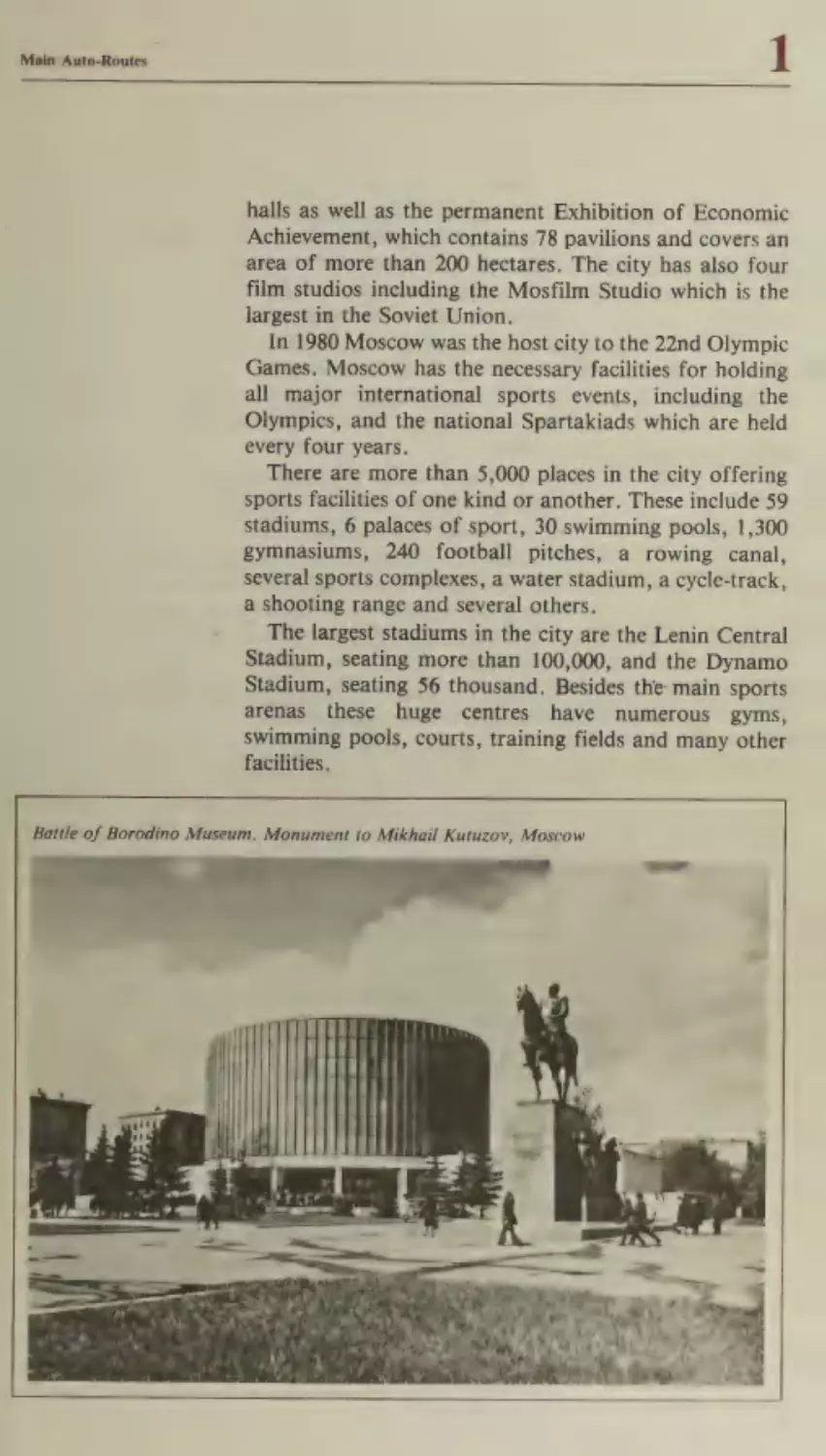
halls as well as the permanent Exhibition of Economic
Achievement, which contains 78 pavilions and covers an
area of more than 200 hectares. The city has also four
film studios including the Mosfilm Studio which is the
largest in the Soviet Union.
In 1980 Moscow was the host city to the 22nd Olympic
Games. Moscow has the necessary facilities for holding
all major international sports events, including the
Olympics, and the national Spartakiads which are held
every four years.
There are more than 5,000 places in the city offering
sports facilities of one kind or another. These include 59
stadiums, 6 palaces of sport, 30 swimming pools, 1,300
gymnasiums, 240 football pitches, a rowing canal,
several sports complexes, a water stadium, a cycle-track,
a shooting range and several others.
The largest stadiums in the city are the Lenin Central
Stadium, seating more than 100,000, and the Dynamo
Stadium, seating 56 thousand. Besides the main sports
gyms,
arenas these huge centres have numerous
swimming pools, courts, training fields and many other
facilities.
Battle of Borodino Museum. Monument to Mikhail Kutuzov, Moscow
Main Auto-Routes
Neen
eee
eee
ee
There are many sights worth seeing in Moscow today,
including outstanding works of architecture past and
present, sculptured monuments to famous people and
memorials of famous historical events.
The most famous historical and architectural monument in Moscow is, of course, the Kremlin. The Kremlin
is the most ancient part of the city, as well as being
its socio-political and cultural centre. It is the seat
of the highest organs of state power in the USSR, the
Supreme Soviet of the USSR and the Soviet Govern-
ment.
The walls of the Kremlin with their 19 towers date
back to the 15th century, when they were the fortifications protecting the inner city.
Inside the Kremlin there are many ancient buildings,
the best known of which are the Cathedral of the
Dormition (1479), the Cathedral of the Annunciation
(1489), the Cathedral of Michael the Archangel (1509),
the Church of the Deposition of the Virgin’s Robe
(1486), the Palace of Facets (1491) and the 80-metre BellTower of Ivan the Great (1508).
Later architectural works include the Cathedral of the
Twelve Apostles and the Patriarch’s Palace (mid-17th
century), the Terem Palace (17th century), the Arsenal
(1737) and the Senate (1787), which today houses the
Soviet Government. It was here in this latter building
that from March 1918 to December 12, 1922 Lenin lived
and worked and his office and small flat have been preserved exactly as they were during his lifetime.
The Armoury (1851) contains a unique display of ancient weaponry, military trophies and the world’s largest
collection of royal garb, regalia, thrones, carriages and
other rare works of Russian and foreign applied art
connected with the history of Russia.
Near the foot of the Bell-Tower of Ivan the Great are
the Tzar Cannon and the Tzar Bell — unique monuments
of Russian 16th-18th-century foundry work.
The most recent building in the Kremlin is the Palace
of Congresses which was built in 1961. Here in the main
hall, which seats 6,000, party congresses, important
public meetings, international congresses, theatrical productions and opera and ballet performances by the
Bolshoi Theatre are held.
Adjacent to the Kremlin is Red Square, the main
square of the capital. Here against the Kremlin walls is
the Lenin Mausoleum. Next to the mausoleum are the
50
Main Auto-Routes
graves and in the Kremlin wall urns containing the ashes
of prominent figures from the Communist Party, the
Soviet State, the world of science and culture and the
international working-class movement.
At the far end of Red Square is St. Basil’s Cathedral
(1560) and a monument (by Ivan Martos, 1818) to Minin
and Pozharsky, the heroes of the national liberation
war against the Polish intervention in the early 17th
century.
By the side of the Kremlin wall that faces the 50th
Anniversary of the October Revolution Square in the
Alexandrovsky Gardens lies the Grave of the Unknown
Soldier, a magnificent monument to all soldiers who
gave their lives during the Great Patriotic War in the
struggle for the freedom and independence of the Soviet
people.
Beyond St. Basil’s Cathedral stands the Rossiya Hotel,
the largest hotel in the Soviet Union (accommodating
6,000). Near the hotel are a number of ancient stone
buildings including the ancient Royal Court (16th-18th
centuries), the House of the Romanovs (1567), the
Church of St. Anne of the Conception (15th century) and
a number of other interesting buildings.
All over the central district of Moscow there are numerous 15th-18th-century historical and architectural
monuments. But for a more detailed description of these
and the many other sights worth seeing in and around
Moscow you are advised to consult the specialist guidebooks.
As well as seeing the many interesting buildings and
monuments in the city, you will also be able to visit the
famous Bolshoi Ballet and attend concerts given by the
State Symphony Orchestra and performances by other
arts companies. Then there are the city’s museums, the
most popular of which are the Lenin Museum, the
Armoury in the Kremlin, the Tretyakov Art Gallery and
the Pushkin Museum of Fine Arts, not to mention the
Borodino Panorama, which reconstructs that famous
battle, and the Exhibition of Economic Achievement,
and much, much else.
Notes for the Motorist in Moscow
1. The four ring roads that encircle Moscow are designated by the Russian letters A, b, B, I’, according to
their proximity to the centre.
51
Main Auto-Routes
2. The main radial roads running from the centre outwards are designated by the numbers 1 to 38 preceded by
the letter M. Numbers M-1 to M-11 are continuations of
the similarly designated auto-routes connecting Moscow
with the major cities of the USSR.
From Moscow there is a choice of six itineraries to
other parts of the Soviet Union.
Itinerary No.
Brest
Minsk
Smolensk
Moscow
Overall distance: 1,060 kilometres
Road surfaces: asphalt, concrete
Recommended time of journey: 2 4-4 days (excluding
the stay in Moscow)
Recommended overnight stops: Brest, Minsk, Smolensk, Moscow
This itinerary runs along the main highway from
Warsaw to Moscow, and is therefore most popular
among motorists coming from the West and from
Eastern Europe
The whole route passes through countryside which is
for the most part level with some slight undulation. The
climatic zone is moderate and the road remains open all
year round, but motorists are recommended to travel
during the period from May to October.
53
Border crossing
Customs
Bureau de Change
Insurance
Filling Station
Service Station
Restaurant
Hotel
Campsite
Intourist Office information
Monument
Yb>
-m
xy
mM
OP
=n Sites
rasnoye
Malyavka
ae
From Minsk to Moscow the road is largely free of
built-up areas. It is also fairly wide and there are no
sharp bends. However, motorists are advised not to drive
at excessively high speeds, especially if they are travelling
on this road for the first time.
In 1976, as a result of the decision to hold the 1980
Olympic Games in Moscow, work was begun on the
building of a new motorway from Brest to Minsk, which
runs parallel with the old road.
The countryside through which the itinerary passes is
very picturesque and has been frequently featured in the
works of many Russian writers and poets. Here there are
undulating plains, pine and birch forests and cultivated
fields, lands which for centuries have been part of the
history of the Byelorussian and Russian peoples.
For more than half of the journey (some 600 kilometres) the road passes through Byelorussia.
Byelorussia
Byelorussia, or as it is officially known, the Byelorussian Soviet Socialist
Republic is located in the west of the vast plane, which lies in the central belt of
the European part of the USSR. With its land area of 207.6 thousand square
kilometres (making it one and a half times the size of England) Byelorussia is the
fourth largest republic in the Soviet Union. The population of Byelorussia is
more than 9.5 million.
For many centuries Byelorussia has been tHe object of aggression from foreign
invaders. It suffered particularly during the Second World War when fascist
Germany invaded the Soviet Union. 2,230,000 people — one quarter of the entire
population — were annihilated during fascist occupation and a further 380,000
were sent to forced-labour camps in Germany.
55
But the brutalities of the invaders could not break the will of the Byelorussian
people to fight for their liberation. More than 213 partisan brigades and 258
separate partisan detachments fought in the enemy’s rear. It was truly a people’s
war.
Almost every town and village in Byelorussia from Brest to Orsha has its
monuments on the mass graves of soldiers and civilians who died in the struggle
with the enemy or were tortured to death in the concentration camps. These
monuments tell of the great sacrifices made by the Soviet people in the last war.
Despite the terrible devastation which the war brought to the economy of
Byelorussia, the Byelorussian people actively supported from all over the Soviet
Union succeeded in reviving their industry and agriculture in a short space of
time.
Yet the war left its effects on the country for a long time afterwards.
Byelorussia is the dnly Soviet republic in which it took 30 years to restore the
population to its prewar numbers.
Today the republic has a developed industry, which plays an important part in
the general economic development of the Soviet Union.
This once backward agrarian outpost of tsarist Russia has now caught up in
the per capita production of a number of important commodities with many capitalist countries, whose industrial development is measured in hundreds of years.
The Byelorussian Republic, whose population is only 4 per cent of that of the
USSR as a whole, produces 15 per cent of its tractors, motorcycles and lines of
automated machine tools, mines more than 20 per cent of its peat and produces
more than 10 per cent of its linen fabrics.
Byelorussian agriculture has also kept pace with industry during the postwar
years.
During the years of Soviet power considerable progress has been made in
Byelorussia in education, science and the health services.
Whereas before the revolution there was not a single higher educational
establishment in Byelorussia, today there are 31 with more than 130 thousand
students.
The scientific centre of the republic is the Byelorussian Academy of Sciences
which brings together 30 separate research institutes. The Academy of Sciences
library is the second largest in the republic with a collection of over 2 million
books.
The development of industry and agriculture, the growth of the material wellbeing of the population and the raising of the general level of education have
brought about a flowering of culture and the arts in the Byelorussian Republic.
There are now 14 theatres, a conservatoire, the State Academic Choir, a film
studio, producing feature and documentary films, and 46 museums. The writers,
composers and artists of Byelorussia have produced many outstanding works.
Main Auto-Routes
The first overnight stop on the route from Warsaw to
Moscow is usually Minsk, where there are comfortable
hotels, a motel and an excellent campsite. To arrive in
Minsk before nightfall, you are recommended to leave
Warsaw early in the morning so as to reach the Soviet
frontier by midday.
However, if you would rather spend alittle time in
Brest so as to see something of the town, you can stay at
the Intourist Hotel, in which case you can arrive at the
Soviet border at any time.
The Intourist offices at the border crossing are located
right by the side of the road bridge across the Western
Bug. Here you can receive all the documents and
information you require, change your money and take
out insurance.
Brest
Brest is the first Soviet town on the road from Warsaw
to Moscow. It is located on the right bank of the Western
Bug, where it joins the River Mukhavets. Brest is one of
Brest Fortress Memorial Complex
we
Street
ae
1 Intourist Hotel*
4 Monument to V. I. Lenin
2 Regional Local History
5 Monument to soldiers
Museum
3 Brest Fortress Defence
Museum
58
killed during the Great
Patriotic War
BREST FORTRESS
MEMORIAL
COMPLEX
1 Main Entrance
5 Parade Square
11 Kholmsky Gates
2 Eastern section of main
6 Main Monument
12 Terespol Gates
7 Sabre Obelisk
13 Defence Staff
rampart
3 Sculptural group Thirst
8 Memorial plaques
4 Ruins of the White
9 Eternal Flame
Palace
10 Ruins of the Engineering
Directorate building
Headquarters
14 Brest Fortress Defence
Museum
15 East Fort
the oldest towns in Byelorussia, its first mention in the
chronicles going back to 1019 A.D., where it is described
as a fortress town at the border between Lithuanian and
Polish lands. The ancient trade routes which went from
Poland and the Baltic to Kiev, Galicia, Volhynia and the
Black Sea led through Brest.
Over the centuries the city has been of political and
strategic importance and it has witnessed many historical
events. Here, for example, in 1918 the Peace Treaty of
Brest-Litovsk was signed.
At the outbreak of the Great Patriotic War Brest was
the scene of bitter fighting. Here the heroic garrison of
Brest Fortress fought on desperately for a whole month
though completely cut off by overwhelmingly superior
forces. In honour of this Brest Fortress was awarded the
title of Fortress-Hero during the celebrations for the 20th
anniversary of the victory over fascism. On September
25, 1971 the Brest Fortress-Hero Memorial Complex was
opened on the site of the fortress. Designed by a group of
architects headed by the famous Soviet sculptor, Alexander Kibalnikov, this memorial complex is a magnificent
59
Main Auto-Routes
ensemble, which harmoniously combines the old
buildings and the ruins of the fortress with a number of
new monumental sculptural and architectural works. In
the centre of the fortress, next to the main monument
stands a 100-metre obelisk in the form of a bayonet as a
symbol of military glory and honour. On clear days the
gleaming obelisk can be seen several kilometres away.
In a museum, located in the building of what was the
sappers’ barracks, there are exhibits which show what
took place both in the fortress and in the town during
the summer of 1941.
The town of Brest was badly damaged during the war.
Almost all its factories and the great majority of its
dwelling houses were destroyed.
Today Brest is the administrative, industrial and
cultural centre of the Brest Region. It is also a major
road and rail junction between Europe and the USSR.
The population of Brest is 177,000. The town now has 2
institutes, 7 secondary specialized educational establishments, a theatre, two museums, several cinemas and 38
libraries.
Forty-seven kilometres from Brest on the road to
Minsk lies the small town of Kobrin, which in the 14th
century was the capital of a principality. Here the great
Russian general, Alexander Suvorov, lived for a short
while in 1797 and again in 1800. Among the things worth
seeing at Kobrin are two monuments in honour of the
first victory of the Russian Army over Napoleon (July
15, 1812) and to Field Marshal Alexander Suvorov, the
park on the Suvorov estate and the Museum of Military
History.
The Dnieper-Bug Canal begins at Kobrin. Along this
waterway industrial and agricultural goods are transported to the regions of the Dnieper and Bug basins as
well as abroad. In particular, iron ore from Krivoi Rog in
the Ukraine is sent to Brest along this waterway, and
from there it is shipped to the GDR.
Fifty-five kilometres beyond Kobrin the road passes
through the regional centre of Bereza, which is famous
for the fact that in 1706 during the Northern War Peter
the Great stopped here.
Twenty-one kilometres further on is the village of
Ivantsevichi, where there is a filling and a service station
and a small restaurant.
Further along, to the right of the main road, is the
fairly large town of Baranovichi, where in 1974 a
memorial complex was opened in honour of the 3,000
60
Main Auto-Routes
Czechs who were shot here by the Germans in the last
war.
Several kilometres to the north-east of Baranovichi is
the village of Zaosye, where the great Polish poet and
leading figure in the national liberation movement,
Adam Mickiewicz (1798-1855), was born. Today an
obelisk stands in the village to commemorate this event.
After passing the regional centre of Stolbtsy and the
town of Dzerzhinsk the road leads through to Minsk, the
capital of Byelorussia.
Tourists who are on a camping holiday can spend the
night at the Minsk Campsite, which is located some 18
kilometres to the west of the city amid a forest of pine
trees. Just beyond the turn to the campsite is a motel with
a service and filling station.
MINSK
Minsk is the capital and largest city in the Byelorussian
Soviet Socialist Republic. It is situated on the banks of
the River Svisloch, a tributary of the Berezina and has a
population of 1,276,000.
Yakub Kolas Square, Minsk
MINSK
Yubileinaya Hotel*
Minsk Hotel
No
wo
—
House-Museum of the Ist
RSDLP Congress
Byelorussian State
Museum
an
Byelorussian Exhibition
of Economic
Achievement
Byelorussian State Arts
Museum
~
Byelorussian Union of
Artists’ Palace of Fine
Arts
Monument to V. I. Lenin
co
Oo
Monument to Felix
Dzerzhinsky
10 Victory Obelisk
1 — Monument to Yanka
Kupala
Byelorussian State
Academic Bolshoi
Theatre of Opera and
Ballet
1 w Yanka Kupala
Byelorussian Academic
Drama Theatre
14 Gorky Russian Drama
Theatre
15 Circus
16 Palace of Sport
| |
Batter
~ treet__]
Main Auto-Routes
Minsk is an ancient town, first mention of it dating
back to 1067 A.D. In the early 12th century Minsk was
the capital of an appanage principality and from the 14th
to the 16th century it played an important part in the
formation of the Byelorussian people.
Throughout its long history the city was frequently
burned and plundered by its enemies.
During the Patriotic War of 1812 Minsk was taken and
looted by the Napoleonic armies.
After the victory of the Great October Socialist Revolution and the formation of the Byelorussian Soviet Socialist Republic in January 1919, Minsk became the
capital of Byelorussia.
On June 28, 1941 Minsk was taken by the nazis, who
destroyed 80 per cent of its dwelling houses, almost all its
factories, power stations, schools and recreational establishments.
Minsk remained occupied for three years. But neither
the mass executions nor all the other brutalities suffered
by the inhabitants could break their will. During the
three years of occupation the Minsk underground carried
out no less than 1,500 military operations against the occupying forces making the city a veritable hell for the
invaders. For the courage and heroism shown by the
working men of the city in their struggle Minsk received
the honorary title Hero-City on the 30th anniversary of
the liberation of Byelorussia.
After the war Minsk had to be virtually rebuilt. A new
town centre with its main highway, Lenin Avenue, was
built. Lenin Square, Victory Square, Central Square and
Yakub Kolas Square were all built anew. Large new
parks were laid out and administrative buildings, hotels,
restaurants, shops and sports grounds were built. Where
small villages and wasteland once encircled the city vast
new housing neighbourhoods and a modern industrial
estate were built.
Minsk today is one of the largest industrial centres in
the country. Its main industries are engineering, metalworking and radio-electronics, which account for 60 per
cent of its industrial output. The lorries, tractors, lathes,
computers, ballbearings, refrigerators and radios produced in Minsk are known throughout the Soviet Union
and abroad.
Minsk is also a major cultural and scientific centre.
Both the Byelorussian Academy of Sciences and the
Byelorussian University are located here as are 12 other
higher educational institutes and 22 secondary special64
Main Auto-Routes
2
ized educational establishments. Altogether 120,000
students study in Minsk. The city has 6 theatres: the
Byelorussian Academic Theatre, the Russian Drama
Theatre, the Philharmonic Society, which has three
orchestras, the State Academic Choir, the Circus, the
State Folk Choir and Dance Ensemble.
Minsk has 8 museums: the State Museum of the Byelorussian SSR, which is devoted to the history and culture
of the Byelorussian people, the Exhibition of Economic
Achievement, the Fine Arts Museum, the Museum of the
History of the Great Patriotic War, the House-Museum
of the First Congress of the Russian Social-Democratic
Labour Party, and the literary museums of the
Byelorussian folk poet, Yanka Kupala, and the Byelorussian writer, Yakub Kolas.
Just outside Minsk is the Khatyn Memorial Complex.
Built in 1968 by a group of architects (Yuri Gradov,
Valentin
Zapkovitch,
Leonid
Levin
and_
Sergei
Selivanov, the sculptor) the memorial stands on the sight
of the village of Khatyn which was burned to the ground
by the Germans together with all its inhabitants in 1943.
Where the homes of the villagers of Khatyn once
stood, symbolic stone walls have been erected. Day and
night the bells of the village, mounted on these walls toll
out in memory of the tragedy. Urns with earth taken
from the ashes of the 186 other Byelorussian villages
which were burned to the ground recall the innumerable
sufferings and sacrifices endured by the Byelorussian
people, as do the monument to the inmates of the death
camps and many of the sculptures and memorial
plaques.
After visiting Khatyn you can join the main route via
the Minsk-Vilnius road without returning to Minsk.
Where these two highways meet stands the Mound of
Glory, built in honour of the Soviet victory during the
last war. Here at the village of Sloboda 21 kilometres
along the Minsk-Moscow Highway on July 3, 1944 units
of the Soviet Army met up to complete an offensive
which resulted in the encirclement of 100,000 German
troops. The enemy was thrown back 600 kilometres and
the whole territory of Byelorussia, a considerable part of
Lithuania, part of Latvia and the eastern regions of
Poland were liberated. This magnificent yet simple
monument to the heroism and courage of the Soviet
Army was built in 1967 from earth, stone and metal
(sculptors: A. Bembel, A. Artsimovitch; architects: A.
Stakhovitch, L. Mitskevitch).
65
2
Main Auto-Routes
Thirty-one kilometres east of the Mound of Glory the
road passes through the town of Zhodino. Here the
Byelorussian Automobile Factory is located, which produces heavy (25-120 tonnes) tip-up lorries.
Twenty-one kilometres further on at the town of
Borisov the road crosses the River Berezina. Not far
from this spot on November 14-16, 1812 a famous battle
took place between the Russian and French armies, in
which Napoleon lost a considerable part of his forces
while retreating across the Berezina with the result that
his famous Grand Army ceased to exist as an organized
military force. Today a monument stands in the village in
honour of the Russian victory.
Borisov is virtually the last major built-up area
through which the road passes directly on the route to
Moscow.
Further on (249 km from Minsk) the road crosses the
border between Byelorussia and the Smolensk Region,
which is part of the Russian Soviet Federative Socialist
Republic, the largest republic in the Soviet Union (see
Itinerary No. 1, p. 19).
Seventy-one kilometres further on (670 km from Brest;
320 km from Minsk), where the road branches off to
Smolensk, there isa filling and a service station. There is
St. Nicholas Gates of the Smolensk Fortress
Main Auto-Routes
2
also a sign showing that 2 km to the left of the highway
lies Khvoiny, the campsite of Smolensk. The campsite
lies in the sunny glades of a mixed deciduous and
coniferous forest and consists largely of small chalets.
Fight kilometres to the right of the highway lies the
ancient Russian city of Smolensk and not far from the
turning-off to Smolensk is the motel at which those
travelling by coach and car mostly stay.
Smolensk
;
Smolensk, the administrative centre of the Smolensk
Region, is situated on both banks of the upper Dnieper.
It has a population of 276,000.
The history of the city goes back over many centuries.
Archeologists have shown that as early as the 6th-8th
centuries A.D. the locality was inhabited by an ancient
~ Slavic tribe of Krivichi. In the 9th-10th centuries Smolensk lay on the great waterway which ran ‘‘from the
Varangians to the Greeks’’. The earliest reference to
Smolensk dates back to 863 A.D., where it is spoken of
as a big city.
In the 12th century Smolensk became the capital of the
independent Principality of Smolensk, but in the early
15th century the Lithuanian feudal barons took
advantage of the Tartar-Mongol invasion of Russia and
captured the city. For the next 110 years the city of Smolensk was ruled by the Great Prince of Lithuania.
In 1514 Russian troops returned Smolensk to the Russian state and during the 15th and 16th centuries the city
became a major centre of handicrafts and trade. Between
1596 and 1602 a huge stone wall was built around the city
so as to strengthen its fortifications against enemy
attack. In view of the exceptional importance of Smolensk’s position on the western borders of Russia, it was
known at the time as the ‘‘key to the State of Muscovy’’.
For many centuries Smolensk continued to play an
important role in the defence of the Russian state and its
capital, Moscow.
Many
times its. steadfast and
courageous inhabitants were forced to undergo siege
from an invading enemy. It is this which explains the
meaning of the city’s coat of arms, which depicts a
cannon, symbolizing the fortress city standing in defence
of Russian soil, and a mythical bird symbolizing good
fortune and dominion.
In the early 17th century during the period of Polish
intervention, the inhabitants of Smolensk withstood a
67
SMOLENSK
1 Rossiya Hotel
8 Mater Dolorosa Epitaph
2 Konenkov Museum of
9 Mound of Glory
Pictorial and Applied Art
3 Local History Museum
4 Monument to V. I. Lenin
5 Monument to Mikhail
Kutuzov
6 Monument to Mikhail
Glinka
7 Monument to the Heroic
Memorial Complex
10 Monument to the
St. Sophia Regiment
11 Svirskaya Church (12th
century)
12 Church of St. Peter and
St. Paul at Gorodyanka
(12th century)
Defenders of Smolensk
13 The Dormition Cathedral
(1812)
14 Fortress Walls
Main Auto-Routes
seige lasting 20 months and during the Patriotic War of
1812 a major battle took place at Smolensk (August 4-6).
The Russian troops put up a
stiff resistance but
ultimately were forced to abandon the city to Napoleon.
Later Smolensk lost its importance as an outpost and
became just another provincial town with a relatively
small population and an industry that was largely based
on handicrafts. Before the Great October Socialist
Revolution the two largest industrial enterprises in
Smolensk employed a work-force of less than 100 men
each.
Smolensk was once more taken by foreign invaders in
July 1941, when units of the Soviet Army after heavy
fighting against overwhelming odds were forced to
abandon the city. Fascist troops completely destroyed
the railway junction and the city’s industry and devastated almost all of the buildings including many cultural,
historical and architectural monuments. 7,600 of the
7,900 blocks of flats in the city were left in ruins.
On September 25, 1943 Smolensk was liberated by the
Soviet Army. But the war had left an indelible imprint.
Thousands of the civilian inhabitants had been killed or
tortured in the death camps, thousands more soldiers
and partisans had died fighting for the liberation of their
country. There are many monuments in Smolensk to
those who lost their lives in the last war. They include the
Monument to the Liberators of the City from German
Fascist Occupation, the Mater Dolorosa, a memorial to
the victims of fascist terror, the Hill of the Immortals, a
monument to the Soviet soldiers that died fighting
between 1941 and 1943, and many others.
Since the war the city has been rebuilt and now has
many new industrial enterprises, housing estates and administrative buildings. The main industries of Smolensk
today are textiles, garments, food, knitted goods and
metal-working.
Smolensk has 5 higher and 18 secondary specialized
educational establishments, 2 theatres, 41 cinemas, 3
museums, libraries and other cultural institutions.
Despite the terrible damage done during the last war,
several valuable architectural monuments have been
preserved. These include the St. Peter and St. Paul
Church at Gorodyanka (1146 A.D.) and the Svirskaya
Church (1191-94), which show the distinctive features of
the local school of architecture which was developing at
the time.
The defence wall and towers around the city which
69
' Main Auto-Routes
were built by Fyodor Kon (1595-1602) are an outstanding
example of late 16th-century Russian architecture. A
number of 17th- and 18th-century buildings have also
been preserved including the Cathedral of the Dormition
(1677-79) and a number of other churches and monastery
cathedrals.
The prime example of neo-classical architecture is the
former Nobles Assembly building. In 1885 a monument
by Bok was erected to the composer Mikhail Glinka, a
native of Smolensk. There are also monuments celebrating the heroic defence of the town during the Patriotic
War of 1812. These include monuments to the defenders
of Smolensk and St. Sophia Regiment, and a monument
to Field Marshal Mikhail Kutuzov, which was erected in
1954 (sculptor Motovilov). Many famous Russians have
been born in and around Smolensk. These include
Mikhail Mikeshin, the artist and sculptor (who built the
monument to the Millenary of Russia in Novgorod and
to Bogdan Khmelnitsky in Kiev), the famous Soviet
sculptors Sergei Konenkov and Lev Kerbel (who produced the monument to Karl Marx in Moscow), the
Soviet poets Alexander Tvardovsky and Mikhail Isakov_ sky, the prominent Soviet military commander Mikhail
Tukhachevsky, the aircraft designer Semyon Lavochkin, the founder of modern soil science Vassily Dokuchayev and many others.
Also of interest is the Smolensk Museum of Pictorial
and Applied Art and its branch, the Teremok, and
the church. This latter is located some 18 kilometres
outside the city and is well-known for its murals by
Nikolai Roerich.
The road from Smolensk to Moscow runs 392
kilometres through places that have been made famous
during the Patriotic War of 1812 and the Great Patriotic
War (1941-45). The only built-up areas along this stretch
of the road are filling stations.
One hundred and sixty-four kilometres outside Smolensk the highway skirts the town of Vyazma (lying 2 km
to the right). Here during the Patriotic War of 1812
Russian troops inflicted severe casualties on the retreating Napoleonic army. Here too heavy fighting took place
during the Battle of Moscow (1941-42) between the
Soviet Army and the German fascist invading forces.
Further along and again to the right of the main highway lies the village of Tsaryovo-Zaimishche, which is
famous for the fact that here in August 1812 two Russian
armies under the command of Bagration and Barclay de
70
2
Main Auto-Routes
Tolly joined forces for Field Marshal Kutuzov to take
over the command.
Some 218 kilometres from Smolensk there is a filling
station and a small road-side cafe. Five kilometres from
here is the town of Gagarin, the district centre of the
Smolensk Region. This town, formerly known as
,Gzhatsk, was renamed in 1968 in honour of Yuri
Gagarin (1934-68), the first man in space. The town has
a memorial museum in honour of Gagarin as well as a
local history museum. Not far from the town is the
village of Klushino, where Yuri Gagarin was born.
A little further along the road crosses the boundaries
of the Moscow Region. Sixty-five kilometres from the
boundary is the turning which leads to the ancient town
of Mozhaisk (5 km to the left).
Twelve kilometres to the west of Mozhaisk (18 km
from the highway) is the village of Borodino. Nearby lies
the famous Borodino Field where in August 1812 the
Battle of Borodino took place between the forces of
Napoleon and the Russian army under Kutuzov.
If you leave Smolensk in the morning, then you will
Kalinin Avenue, Moscow
——#
Cor teqcia
gaacesco
Tr
ae
agTR As) =
IT en em =
Main Auto-Routes
have time to visit the Borodino Military-History Museum
and Borodino Field which is now astate reserve and
where over an area of some 50 square kilometres 34
monuments erected to mark the centenary of the battle
have been restored and preserved together with part of
the fortifications. Here too there are also monuments
erected to the Soviet soldiers that were killed in action
against the nazis in the 1941 Battle of Moscow.
Eighty-five kilometres from Moscow, where the road
turns off on the right to the village of Petrishchevo
stands a monument on a high pedestal to Zoya Kosmodemyanskaya, the Komsomol-Partisan and Hero of the
Soviet Union, who was tortured and hanged by the nazis
in the winter of 1941 in the village of Petrishchevo.
After passing the Golitsyno filling station (45 km from
the centre of Moscow) you can see ahead the magnificent
32-storey building of the Moscow University. Shortly
afterwards you cross the Outer Ring Road, which marks
the city limits (for brief information on Moscow see
Itinerary No. 1, p. 42).
At the intersection of the highway and the Outer Ring
Road (20 kilometres from the centre) is a motel and a
campsite, where you can stop off for a rest, wash the car
and fill up with petrol before setting off for the centre of
Moscow.
The route to the centre lies along Highway M-1, which
incorporates the Mozhaisk Highway, Kutuzov Avenue
and Kalinin Avenue. It passes the Triumphal Arch,
which was built in honour of the victory over Napoleon’s
Army in the Patriotic War of 1812, the Battle of
Borodino Panorama building, the Ukraina Hotel and the
CMEA building. The road finally leads into the 50th
Anniversary of the October Revolution Square opposite
the Kremlin.
Itinerary No.
Chop
Uzhgorod
(or SheginiMostiska)
Lvov
Kiev
Orel
Moscow
Overall distance: 1,700 kilometres
Road surfaces: asphalt, concrete
Recommended time of journey: 4-6 days (excluding
stay in Kiev and Moscow)
Recommended overnight stops: Uzhgorod, Lvov,
Rovno, Kiev, Orel, Moscow
The crossing point for road traffic on the SovietHungarian border is the bridge across the River Tissa,
which is near the Hungarian town of Zakhon and 3 kilometres from the Soviet town of Chop.
Crossing the Soviet border here you enter the territory
of the Soviet Ukraine in which most of this itinerary is
located.
73
Border crossing
Customs
Bureau de Change
Insurance
Filling Station
Service Station
Restaurant
Zhelg znogorsk a
Hoiel
Campsite
Intourist Office, infermation
Monument
=
XY
mh
my>
NOB
Sites
OCh
we BAPE
Dee
Pakhra
‘4
cence
The Ukraine
The Ukrainian Soviet Socialist Republic is one of the largest and most economically developed republics in the USSR, and is located in the south-west
European part of the country. Its land area stretches a distance of more than
1,300 kilometres from west to east and almost 900 kilometres from north to
south.
It is the second (after the RSFSR) most populated republic in the USSR (50
_ million) and the third largest in terms of land area (some 604 thousand sq km).
The majority of the-population are Ukrainians, who together with the Russians
and the Byelorussians, are East-Slavic in origin.
The history of the Ukraine is the history of its people’s struggle for freedom
and for the creation of a single national state. In the 9th century A.D. the
territory of what is now the Soviet Ukraine was the Old Russian State of Kievan
Rus, from which the Ukrainian, Russian and Byelorussian peoples all derive their
origins. In the 12th century the Lithuanian and Polish feudal barons conquered
the Ukraine, while at the same time the Ukrainian people had to fight against the
aggression of the Crimean Tartar hordes and the Sultan of Turkey.
The war of national liberation (1648-54) in which the Ukrainian people rose
under Bogdan Khmelnitsky against their Polish overlords ended in the reunification of the Ukraine with Russia. This saved the Ukrainians from slavery at the
hands of foreign invaders and gave them the opportunity for economic and cultural development.
Since 1654 the destinies of the two peoples have been inseparably linked and
from that time the Russians and the Ukrainians have fought together against
their enemies. Thus in the Northern War against the Swedish invaders (1709), in
the war against Napoleon, in the years of revolutionary struggle against tsarism
and during the period of Civil War and foreign intervention (1918-22) the two
nations fought side by side.
On December 25, 1917 the First All-Ukrainian Congress of Soviets proclaimed
the Ukrainian Soviet Socialist Republic and on December 30, 1922 the Ukraine
joined the Union of Soviet Socialist Republics.
During the Second World War the Ukraine was one of the first republics to be
attacked by the invaders and be temporarily occupied. But foreign invasion and
occupation could not break the will of the Ukrainian people, who launched a
broad partisan campaign and took up the struggle for the independence of their
socialist Motherland.
At the end of the war all Ukrainian lands were united into a single socialist
state.
75
The Ukraine today has a highly developed agriculture, industry, science and
culture.
The favourable climate and fertile lands have a beneficial effect on Ukrainian
agriculture, producing the famous Ukrainian wheat. The total area under cereals
in the Ukraine is in excess of 17 million hectares. Rich harvests of other crops like
sun-flower seeds, maize, potatoes, rice and tobacco are also yielded here, while
the Ukraine is the world’s largest producer of sugar beet.
The Ukraine is also rich in minerals. The vast deposits of coal, iron and
manganese ores have led during the Soviet period to the large-scale development
of the coal, iron-and-steel, metal-working and engineering industries in the
Ukraine, while the oil and gas industries are expanding at a considerable rate.
The Soviet Ukraine turns out approximately half of the pig iron, over 40 per
cent of the steel, some 50 per cent of the iron ore and coke and almost 40 per cent
of the coal produced in the USSR.
Another area of rapid development and expansion in the Ukraine is housing.
Before the revolution there was not a single school in the republic which used
the Ukrainian language, and 76 per cent of the population were illiterate. Today
illiteracy has been totally eradicated. There are 26 thousand schools with more
than 8.3 million pupils and 143 higher educational colleges with a total of
900,000 students.
The scientific centre of the republic is the Ukrainian Academy of Sciences,
which was formed in February 1919. Today there are some 800 scientific institutes employing more than 100,000 scientists.
The art and culture of the Ukraine is clear and distinctive. It is characterized by
humanism, emotion and undying optimism.
Some 50 of the 68 professional theatres in the republic perform in the
Ukrainian language. There are some 4.5 million people involved in the various
amateur arts groups which are active in the Ukraine, and in which many
professional actors began their careers.
There are some 2,500 newspapers published in the republic (almost 2,000 of
which are in Ukrainian) with a daily total circulation of 25 million. There are also
more than 28,000 libraries with a total of 250 million books, several film studios,
producing feature and documentary films, and 154 museums.
The Ukraine has one of the highest per capita allocations of doctors in the
world. Whereas there were only 28,000 doctors in the whole of tsarist Russia, in
1975 there were 157,000 in the Ukraine alone.
As a result of the growth of material welfare, and the improvement of labour
and living conditions, average life expectancy in the republic is 72 years, while
according to the 1959 census the number of those over 100 years old per million
of the population amounted to 57 (the corresponding figures for Britain, France
and the United States are 6, 7 and 16 respectively).
As you travel through the Ukraine, you will be able to see the life of the Ukrainian people and judge the achievements of a republic whose towns and villages
have during the lifetime of one generation been destroyed three times by the
hurricane of war and twice made to suffer foreign occupation.
Main Auto-Routes
The first Ukrainian town on the itinerary is Chop. This
small Transcarpathian border town stands on the plain at
the foot of the mountains where the borders of the
USSR, Hungary and Czechoslovakia meet. Chop is an
important junction servicing road and rail transport to
and from the USSR and every day hundreds of people
pass through the town.
Twenty-three kilometres from Chop on the banks of
the River Uzh and surrounded by the forests and
vineyards of the Carpathians lies the town of Uzhgorod.
Tourists arriving in the Soviet Union from Czechoslovakia also begin their itinerary from here, for Uzhgorod is the first major Soviet town on the E-85 Highway
which runs from KoSice in Czechoslovakia crossing the
Soviet frontier at VySne Nemecké.
Since tourists are advised to stay the night at Lvov (262
kilometres beyond Uzhgorod), it is advisable to arrive at
the Soviet frontier in the morning. Allowing for the fact
that the road passes through the mountainous country of
the Carpathians at the Mukachevo-Stryi stretch the
journey from Uzhgorod to Lvov should take between 5
and 7 hours not counting the time spent in sightseeing
round Uzhgorod itself. Those tourists who arrive at
Uzhgorod in the afternoon may, of course, stay the night
there.
Uzhgorod
The ancient Slavic town of Uzhgorod from the 11th
century was annexed from Kievan Rus and for many
centuries remained under foreign occupation. Many
times the people of Transcarpathia rose up against their
enslavers, but their insurrections were always brutally
put down.
For a short period of five months following the 1919
revolution in Hungary Soviet power was proclaimed in
Transcarpathia, but through the efforts of the Entente
powers and internal counter-revolution, the Soviet
republic was crushed and Transcarpathia made part of
Czechoslovakia. In 1938 the government in Hungary
partially annexed Transcarpathia and in the following
year completed this annexation. However, in June 1945
at the end of the Second World War the Transcarpathian
Ukraine was reunited with the Soviet Ukraine according
to a treaty between the Republic of Czechoslovakia and
the USSR. Thus Transcarpathia became a region of the
Ukrainian Soviet Socialist Republic and Uzhgorod was
made its administrative centre.
77
Main Auto-Routes
The main wealth of Transcarpathia lies in its timber,
for forests occupy half the entire territory of the region.
Thus the timber, wood-working and furniture industries
play an important role in the economy of Uzhgorod.
The Uzhgorod district has long been famed for its
wines and Transcarpathia provides a quarter of all the
wine produced in the Ukraine.
As well as being the administrative centre, Uzhgorod is
also an important cultural centre. In 1945 the Uzhgorod
State University was opened and today 4,000 students
study in its six faculties. The town has a number of
educational colleges including the Music College and the
College of Applied Art.
Among the architectural monuments of interest in
Uzhgorod is the Uzhgorod Castle, whose grey eminence
towers above the town. Here more than one thousand
years ago lived the Old Russian Prince Laborets. Since
then the castle has had additions frequently made to it.
In 1842 an original iron statue of Heracles killing the
Lernean Hydra and a copy of the famous sculpture by
Lisippus Hermes at Rest were placed in the courtyard. In
the castle grounds there are the remains of an old Roman
Catholic church. The main building of the castle is
pened &
Castle
Harvest Festival in Transcarpathia
UZHGOROD
1 Uzhgorod Hotel
4 Botanical Gardens
8 Philharmonic Society
2 Kiev Hotel
5 Monument to V. I. Lenin
9 Cathedral. University
3 Castle. Local History
6 Mound of Glory
Museum. Picture Gallery
7 Opera House
Library
10 University
rectangular with square towers in the four corners. It was
originally built in the 10th century and again rebuilt in
1598.
Today the Uzhgorod castle houses a local history
museum, which has more than 30 thousand exhibits, and
a state picture gallery with more than 2,000 paintings,
graphics and sculptures by Russian, Ukrainian and
foreign artists.
Also of architectural interest is the university library,
which was built in 1644 for a Jesuit monastery, which
after the order was dissolved in 1775 became the resi79
Main Auto-Routes
dence of the Uniate Episcopy. The library which has
more than 600,000 books, also contains some 70 Old
Russian manuscripts, a valuable collection of 16th-17thcentury early editions and many 18th- and 19th-century
books.
Next to the library stands the cathedral, which was
built at the same time as part of the Jesuit monastery,
and later turned into an Orthodox church.
The Regional Philharmonic Society building and a
number of other buildings in the ancient part of the town
are also of some interest.
In Uzhgorod there is also a Mound of Glory, erected in
memory of the Soviet troops who liberated the town, a
zoological museum, a botanical gardens with more than
3,000 types of plants and a recreation park.
There are more than 300 mineral springs in the
Carpathians containing carbonic, hydrated, methane
and hydrogen-sulphide waters which are all possessed of
excellent medicinal qualities. Particularly well known are
the Naftusya springs at the Truskavets health resort,
whose waters are used in the treatment of kidney, liver
and stomach disorders.
These mineral springs together with the mild climate
and the mountain air make Transcarpathia an excellent
health resort. Here an extensive programme has been
undertaken to modernize old and build new sanatoria,
rest homes, hotels, boarding houses and other facilities
for tourists and holidaymakers. In Transcarpathia alone
more than 300,000 workers from all over the Soviet
Union spend their holidays every year.
Twenty-two kilometres outside Uzhgorod on the road
to Lvov is the village of Sredneye which contains the
ruins of an ancient 16th-century castle.
Twenty kilometres further on you come to the town of
Mukachevo, which is set in the midst of a huge amphitheatre formed by a steep craggy range of mountains.
Mukachevo
Mukachevo is one of the main towns in Transcarpathia. Founded in the 10th-11th centuries, the town
witnessed many anti-feudal uprisings, particularly in the
late 17th and early 18th centuries.
The oldest historical monument in Mukachevo is the
Palanok Castle which stands on a steep hill on the
southern edge of the town and was built in the 14th century as an impregnable fortress.
Besides the castle there is also an 18th-century palace,
80
Main Auto-Routes
3
known as the White House, a 14th-century Gothic
chapel, a monument to the victory of the insurrectionists
at Sorochya Gora in 1849 and a monument to the
partisans who fought in the Great Patriotic War.
An interesting example of Ukrainian folk architecture
is the wooden church, which was built in the 18th century, and which was transferred from the neighbouring
village of Shelestovo in 1927.
Also of interest is the town park, on the left bank of
the Latoritsa which has a particularly distinctive design.
Beyond Mukachevo the road winds up the wooded
slopes of the Carpathians giving beautiful views across
the mountainous landscape.
To the right of the road deep in the Latoritsa Valley
lies the timber town of Svalyava. The whole of the Svalyava depression is rich in mineral springs and there are
several factories here producing bottled mineral water.
Other places of interest in and around Svalyava include
the trout farm, where trout are artificially bred and then
released into the rivers of Transcarpathia.
Owing to the excellent climatic conditions, the
medicinal springs and the beauty of the natural landscape, the whole area around Svalyava has become very
popular as a holiday resort. Several sanatoria have been
built here including the Carpathians Sanatorium, which
now occupies the hunting lodge that once belonged to
Count Schénborn, and the Sinyak, which is built to resemble a group of Swiss mountain chalets.
After crossing the Middle Veretsky Pass (841 metres
above sea level) the road descends the gentle slopes of the
Eastern Carpathians through the mountain resort of
Skole into the valley of the River Stryi. Here lies the
industrial town of Stryi, a major transport junction in
the Lvov region.
The Stryi district has some of the largest deposits of
natural gas in the Ukraine, and it is from here that the
Dashava-Kiev, Dashava-Minsk and Ugersk-Lvov gas
pipelines run to provide natural gas for many parts of the
Soviet Union.
Sixty-nine kilometres further on and you can see the
first buildings of Lvov, a town renowned for the beauty
and originality of its architecture and its fine parks and
boulevards.
Tourists entering the USSR from Poland along the
European International Motorway E-22 cross the Soviet
frontier at Shegini (74 km west of Lvov). The road passes
through
undulating
countryside,
but avoids
the
81
Main Auto-Routes
mountain passes of the wooded Carpathians.
Six kilometres from Shegini the road passes through
the village of Mostiska and 38 kilometres further on
enters Gorodok, one of the oldest cities in the Lvov
Region, which is mentioned in the earliest Russian
chronicles. In those days it stood on the salt-route from
Pszemysl in Poland to Kiev and was known as ‘‘Salty
Town’’.
For many centuries the town took an active role in the
struggle of the Ukrainian people for national liberation
from their Polish overlords. In 1655 a major battle was
fought here between Bogdan Khmelnitsky’s Cossacks
and Polish troops under Pototcki which ended in
Pototcki’s army being completely defeated and their
commander barely escaping with his life.
Among the interesting architectural monuments in
Gorodok is a Roman Catholic church built in 1419, an
Orthodox church (1510) and the wooden Ivanovskaya
(St. John the Baptist) Church built in 1670.
The distance from Gorodok to Lvov is 29 kilometres.
Lvov
The ancient Ukrainian city of Lvov has a long and
interesting history. Founded in 1256 by Prince Daniil
Galitsky, the city was named in honour of his son, Lev.
Its elevated position on the Lvov Hills helped to make
the city a natural fortress. But its high walls and turrets
were unable to guarantee Lvov freedom and independence. Despite the fierce resistance offered by the inhabitants of the city, they frequently suffered from enemy incursions.
In the 13th and 14th centuries the smelters, blacksmiths, gold and silversmiths of Lvov enjoyed a high
reputation.
It was to the St. Onuphrius Monastery in Lvov that
Ivan Fyodorov, the printer of the first Russian books,
eventually came to settle in 1572 after long wanderings.
Here he set up his printing-press and was eventually
buried in 1583.
After the first partition of Poland in 1772, Lvov
together with the whole of Galicia fell under Austrian
dominion and was renamed Lemberg. From 1867 to 1919
the city was part of the Austria-Hungary.
After the victory of the Great October Socialist Revolution in Russia, the Ukrainian bourgeoisie, which had
come to power in the Western Ukraine and founded the
82
Main Auto-Routes
3
West-Ukrainian People’s Republic, brutally crushed the
revolutionary uprisings of the people and in 1919 opened
the way for the occupationist armies of bourgeois
Poland.
In October 1939 the People’s Assembly of the Western
Ukraine proclaimed the establishment of Soviet power
and on November 1, 1939 the Western Ukraine was
accepted into the Soviet Union.
The nazi invasion of the Soviet Union in 1941 once
more disrupted the peaceful development of the city. The
fascists set up a regime of terror and plunder in occupied
Lvov, but as in other cities and towns of the Ukraine they
could not break the will of the patriotic inhabitants. All
over the Lvov Region furious partisan warfare went on
unabated
throughout
the whole
period of the
occupation. The exploits of the Soviet soldiers who laid
Monument to Adam Mickiewicz, Lvov
iv
hes
Klos
2.
mad
LVOV
€unificatio
ae
3
a
Main Auto-Routes
1 Intourist Hotel*
_ 2 Lvov Hotel
3 Museum of the History
of Religion and Atheism
4 Museum of Ethnography
9 Monument to Adam
Mickiewicz
10 Memorial Complex and
Mound of Glory Museum
11 Cathedral
16 Market Square
17 St. Onuphrius Church
18 State Academic Theatre
of Opera and Ballet
19 Zinkovetskaya Ukrainian
and Handicrafts
12 Armenian cathedral
5 History Museum
13 Gun-Powder Tower
6 Picture Gallery
14 Royal Arsenal
peta Wheatre
20 Organ Hall at the Lvov
7 Monument to V. I. Lenin
15 Church of the
State Conservatoire
8 Monument to Ivan
Franko
Dormition. Kornyakta
21 Stryi Park
Tower. Chapel
22 Palace of Sports
down their lives for the liberation of Lvov are recalled by
monuments in various parts of the city and on the
Mound of Glory, where Russian soldiers who died
fighting for Lvov in the First World War lie buried. Also
on the Mourid of Glory lie the mortal remains of the
legendary partisan hero, Nikolai Kuznetsov, whose
exploits have become part of the glorious annals of the
Soviet people in the Great Patriotic War.
After the war Lvov with its 667,000 population rapidly
developed as a major industrial and cultural centre. The
buses, fork-lift trucks, colour and black-and-white television sets, television tubes and various other electronic
equipment and machinery produced in Lvov are known
throughout the Soviet Union and abroad.
Lvov has 12 higher educational institutes and more
than 30 secondary specialized educational establishments
with a total of more than 55,000 students.
There are 10 museums, the most noteworthy of which
is the Picture Gallery. Founded in 1907 the gallery has
more than 10,000 exhibits including works by Titian,
Goya, Rubens and other old masters. Also of interest are
the Museum of Ethnography and Handicrafts, which
contains examples of 16th-20th-century
Ukrainian
applied art and the Museum of National Architecture,
which contains examples of West-Ukrainian wooden
architecture.
Lvov has 5 theatres, the Trembita Choir and a philharmonic society.
85
Main Auto-Routes
The Stryi Park, which was founded in 1877, is among
the finest in Europe.
For those tourists interested in history and architecture
Lvov is of especial interest. The city’s monuments
include the Cathedral (1360-1493, architects: Pshtekher
and Grom) with its 65-metre spire, which stands in Rosa
Luxemburg Square; the Armenian cathedral (late 14th
century); the Wallachian Church of the Dormition (1591)
with its Renaissance-style bell-tower and Kornyakta
Tower, which stands on Russkaya Street; the walls of the
Jewish Synagogue (1582) and the Porokhovaya (GunPowder) Tower (1565) on Podvalnaya Street. Among the
later buildings are the church of the Bernardines (early
17th century) on Reunification Square and the 16th-17th
century Renaissance-style buildings on Market Square,
of which the most noteworthy are the former palace of
King Jan Sobiesski and the house where Peter the Great
stayed in 1709 (both of these buildings are now occupied
by the Lvov Museum of History). Also of interest
architecturally are the Church of St. Yura (1745-70) with
its huge early 14th-century bell, the Jesuit church (1635),
the Boimi Chapel (1617) on Kapitulnaya Square and the
Royal Arsenal (17th century).
Other early ecclesiastical buildings include the Church
of St. Nicholas (13th century), the St. Paraskeva Pyatnitsa Church (17th century) and the Church of St. Onuphrius (16th century), where Ivan Fyodorov, the first
Russian printer, lies buried, the Dominican, Benedictine
and Carmelite churches, the Church of Maria Snezhnaya
(13th-17th centuries) and the wooden 18th-century
church, which was brought to Lvov in 1930 from the
village of Krivki.
There are also many late 19th- and early 20th-century
buildings in Lvov. These include the House of the
Galician Assembly (the Sejm) which is now the main
building of Lvov University; the Palace of Count
Pototcki which now houses two institutes of the Ukrainian Academy of Sciences; the Opera House (seating 1,110)
built by Gorgolevsky in 1897-1900; and a distinctively
designed building, built in 1904, which now houses the
Lvov branch of the Central Lenin Museum, Also of
some architectural interest is the Polytechnical Institute,
which was built between 1872 and 1877.
In Mickiewicz Square, the town centre, there is a fine
monument to Adam Mickiewicz, which was erected in
1905 in celebration of the 50th anniversary of the great
86
Main Auto-Routes
-
Polish poet’s death (architects: A. Poppel and M. Parashchuk).
There are several buildings in Lvov connected with the
life and work of Ivan Franko, the great Ukrainian poet
and revolutionary. Franko lived in Lvov for more than
40 years and today the Lvov University, which is one of
the oldest in Europe (founded in 1661), bears his name.
Continuing the journey from Lvov the road runs
north-east through small towns and villages to Rovno.
Twelve kilometres outside Lvov and set amid a grove
of green trees is the Lvov Campsite.
Forty-five kilometres further on the road passes
through the small town of Busk, which was known in the
11th century as a central town of Volhynia. The remains
of the ancient settlement and fortifications have been
preserved.
In the town of Olesko (24 km from Busk) there is a
15th-century Capuchin church and 8 kilometres further
on in the village of Podgortsy there is a castle, an 18thcentury Roman Catholic church and a wooden church
built in 1720. 20 kilometres from Podgortsy the road
passes through Brody, which was founded in the 12th
century. The town possesses a number of interesting
architectural monuments including a Roman Catholic
church (1596), a castle (1630) and the Church of St.
George (16th-18th centuries).
Further along the road (164 km from Lvov) is the
small Ukrainian town of Dubno on the River Ikva. It was
from Dubno that King Charles XII of Sweden fled
during the Northern War (1700-21) on hearing of the
arrival of Russian troops. So hasty was his retreat that he
was forced to leave behind considerable amounts of
equipment including 28 bronze cannons which he
ordered to be buried in the earth.
There are still traces of the defence ramparts of Dubno
preserved today as well as a 17th-century monastery and
a 16th-century castle.
Forty-five kilometres further on lies the town of
Rovno, the administrative centre of the Rovno Region.
Rovno
In the middle ages Rovno was ruled by various Lithuanian, Ukrainian and Polish feudal barons. The last of
these were the Lyubomirskys. In 1793 the Volhynia lands
which for more than two hundred years had been under
Polish domination, broke away and joined Russia, and
Rovno became the uyezd (district) centre of the Volhynia
87
3
A tel
ON
Main Auto-Routes
Province. With the coming of the railways to Rovno in
the late 19th century, the town began to have direct
cultural and economic links with Central Russia. Even
so, industry here continued to develop very slowly.
During the Civil War and foreign intervention (191822) Rovno was the scene of bitter fighting. It was in this
warfare that Oleko Dundié, a glorious son of the Serbian
people who had become a legend in his own lifetime, was
killed in 1920. Today a monument stands above his grave
in the town park.
In 1921 according to the Treaty of Riga Rovno was
again annexed by Poland and it was not until September
1939 when the Western Ukraine was united with the
Ukraine that Rovno became Soviet. However, soon after
the fascist invasion of the Soviet Union, the town once
more suffered foreign occupation.
Since the war Rovno’s economy and culture have
undergone rapid development. Today the town has more
than 40 factories producing light-industrial goods, food,
finished metals and building materials. The flax combine
in Rovno is the largest in Europe.
Whereas before 1939 the town had nothing but a
handicraft industry, worked largely by an illiterate
labour force, today the overwhelming majority of
workers in Rovno have secondary and specialized
education. Every fourth inhabitant of the city is engaged
in one or other form of study.
The town has 3 higher and 7 secondary specialized
educational institutes and some 30 technical colleges and
schools including several evening schools where young
- men and women can complete their secondary education
while still at work.
As in other towns and cities of the USSR much
attention is given to the young inhabitants of Rovno. The
town has its Young Pioneers’ Palace, where children can
take up various hobbies or studies in their free time.
There are special places where young ‘‘engineers’’ can
develop their interests and there is also a children’s railway with all the facilities for teaching children about the
workings of a real railway.
The monuments of architectural interest in Rovno
include the wooden Church of the Dormition (1756) and
the old Gymnasium, built in the classical style (1839).
Sixty-six kilometres east of Rovno is the small town of
Korets. Here the ruins of a 16th-century castle have been
preserved as well as a 16th-17th-century Roman Catholic church.
88
Main Auto-Routes
Forty-four kilometres further on the road passes
through the ancient Ukrainian town of NovogradVolhynsky, which was founded in the 13th century. In
one of the houses the Ukrainian poetess, Lesya Ukrainka, was born in 1871 and it now contains a small
memorial museum. There are also the ruins of a 14th15th-century castle, which once belonged to the
Ostrozhsky Princes.
The next main town on the route is Zhitomir, 187
kilometres from Rovno.
Zhitomir
Zhitomir is the administrative centre of the Zhitomir
Region. It was founded in the 9th century and is
mentioned in the ancient Russian chronicles for the first
time in 1240. Much of its history is connected with the
struggle of the Ukrainian people to free themselves from
the yoke of Polish feudal domination. In 1648 the town
was liberated by Bogdan Khmelnitsky.
In 1793 Zhitomir became part of Russia and soon grew
to importance in the Province of Volhynia. Bitter
fighting took place here during the Civil War and foreign
intervention and many famous Soviet military commanders
like Budenny,
Voroshilov,
Shchors
and
Kotovsky fought here.
Today Zhitomir is the administrative, cultural and
industrial centre of the Zhitomir Region.
During the years of Soviet power the town has grown
significantly. A number of industrial enterprises have
been built here, one of the latest and largest of which is
the Zhitomir Flax Combine which turns out in excess of
20 million metres of household and industrial fabrics
annually.
Zhitomir has long been known for its gardens, parks
and boulevards, and there are particularly beautiful
gardens on the rocky banks of the Teterev which runs
through the town.
In the environs of Zhitomir there are valuable deposits
of facing rock which have only been quarried during
Soviet times. The various marbles—red, pink and
white, the granites and the ‘‘silver’’ labradorite have
been used in building all over the Soviet Union,
particularly on Lenin’s Mausoleum in Red Square, the
Moscow metro stations and Moscow University.
Many places in Zhitomir have been made famous
through their connections with famous figures from the
world of science and culture.
89
Main Auto-Routes
The great Ukrainian poet, writer and social thinker,
Taras Shevchenko, visited the town frequently, Mikhail
Kotsyubinsky, the Ukrainian classic writer, lived and
worked here and Vladimir Korolenko, the famous
Russian writer, was born and spent his childhood in
Zhitomir. Zhitomir was also the birthplace of Jaroslaw
Dabrowski (Dombrovsky), the Polish revolutionarydemocrat and hero of the Paris Commune and Sergei
Korolyov, the designer of the first Soviet space craft.
Monuments to both these famous men have been erected
in the town.
Other monuments of architectural interest include the
former Town Hall (17th century) and a Roman Catholic
church (18th century). Zhitomir has three museums
including memorial museums to Vladimir Korolenko and
Sergei Korolyov.
Another two hours journey (130 kilometres) through
picturesque groves and country villages and you reach
Kiev-Pechersky Lavra, view of the Kovnir
Building
Main Auto-Routes
5
Kiev, the capital of the Soviet Ukraine. The Kiev Motel
and Prolisok Campsite at which most motorists stay are
located in the district of Svyatoshino which is just
outside the city on the Kiev-Zhitomir road. Here there is
a filling station and a service station.
Kiev
Kiev is the administrative and cultural centre of the
Ukrainian Republic. It is not merely one of the oldest
and largest cities in the USSR, it is also one of the most
beautiful. Kiev stands on the picturesque banks of the
Dnieper and is clothed in a mantle of luxuriant greenery.
According to archaelogists the earliest settlements in
Kiev date back to the Ist century A.D. Ancient legend
has it that the city derives its name from the Slavic Prince
Kii.
By the 9th century Kiev was the political centre of one
Viadimirskaya Gorka, Kiev
KIEV
BS
ay
1 Intourist Hotel*
2 Dnieper Hotel*
ad
3 Lybed Hotel*
C/p;
likoy
4 Desna Hotel*
we
5 Prolisok Motel and
Campsite*
arkhomenko
Moskva Hotel
>
Leningradskaya Hotel
Street
MS:
Ukraina Hotel
Teatralnaya
wo
nN
waownrt
Hotel
10 Slavutich Hotel
11 Ukrainian Exhibition of
Economic Achievement
12 Museum of Ukrainian
Pictorial Art
~—_
&
ST: AA Ta?
Zhitomir
1Ww Ukrainian Museum of
Lay, 3H
the History of Medicine
|
14 Ukrainian History
Museum
15 Ukrainian Museum of
Jewelry
16 Monument to V. I. Lenin
17 Monument to Bogdan
Khmelnitsky
18 Monument to Prince
Vladimir
19 Memorial Complex at the
Park of Eternal Glory
20 Golden Gates
21 — St. Sophia Cathedral and
Historical and
Architectural MuseumReserve
22 Kiev-Pechersky Lavra
(Monastery)
23 Church of St. Cyril
24 Church of St. Vladimir
25nN Vydubetsky Monastery
26 Church of the Saviour at
Berestovo
27 Mariinsky Palace
28oo Shevchenko State
Academic Theatre of
Opera and Ballet
29 Circus
30 Dynamo Stadium
;
EEL 2s EEA:
—
Main Auto-Routes
of the most powerful of the East Slavic states and during
the 10th and 11th centuries became the capital of the
early feudal state of Kievan Rus which was then at its
height. Many monumental palaces, churches, gates and
arches were built during this period, while the
monasteries of the times are renowned for their elegance
and rich ornamentation.
In 1037 during the reign of Prince Yaroslav the Wise
building was begun on the Cathedral of St. Sophia,
which has now adorned the city for more than 900 years.
In those days Kiev was an important centre of international trade and played an important role in spreading
enlightenment and culture amongst the population of the
old-Russian state. Here in the Pechersky Monastery in
the early 12th century the first collection of the Russian
chronicles, The Tale of Bygone Years, was compiled.
The Tartar-Mongol invasion of Russia and their occupation of Kiev destroyed the city’s political importance
as capital of Kievan Rus. The lands of Kiev were kept
separated from Russia for a long time for even after the
Mongols had left they fell under the domination of the
Lithuanian, Polish and other foreign feudal barons for a
period of almost 300 years.
The reunification of the Ukraine with Russia in 1654
was the result of a long struggle for national liberation
against their Polish overlords and it contributed considerably to the growth of the economic and cultural life
of Kiev. When the Right-Bank Ukraine joined Russia in
1793 Kiev became centre of a province.
In 1834 the first university was opened in Kiev, which
later became the scientific centre of the Ukraine (the
university building was built in 1842 by V: Beretti).
During the late 19th century there were rapid developments in Kiev’s industry and building.
After the Great October Socialist Revolution political
power in Kiev was seized first by the Ukrainian bourgeois-nationalist Central Rada (Council) and then by
German troops who occupied the whole of the Ukraine
in 1918. But on June 12, 1920 Kiev was finally liberated
by the Red Army.
In 1934 Kiev was declared capital of the Soviet
Ukraine (in place of Kharkov), a measure which to a
considerable degree corresponded with the rapid growth
of the city. However, this was again interrupted by the
invasion of fascist Germany. After three months heroically defending Kiev, Soviet troops were forced to
abandon the city in September 1941. For 778 days Kiev
94
Main Auto-Routes
was in the hands of the invaders, who during that time
plundered and ruined more than one thousand industrial
enterprises and destroyed over 6,000 buildings. During
the occupation more than 200,000 civilians were wiped
out and a further 100,000 forcibly sent to Germany. By
1943 the population of Kiev had been reduced to almost
a fifth of its prewar size.
In November 1943 units of the Soviet Army under the
command of General Nikolai Vatutin liberated Kiev
after long and heavy fighting. In 1957 a monument was
raised to the soldiers who fell in the defence and the
liberation of Kiev. It was placed in the Park of Eternal
Glory together with the Obelisk of Glory and the Tomb
of the Unknown Soldier.
After the war the city of Kiev was awarded the title of
Hero-City for the heroic defence put up by its
inhabitants between July and September 1941.
Thanks to the tremendous help given to Kiev by other
cities and towns in the USSR, the city was rapidly rebuilt
after the war.
Kiev today is the third largest city in the USSR and one
of the largest producers of machine-tools and precision
instruments in the country. Building, food and light
industries have developed rapidly and Kiev is now an
important cultural and scientific centre.
A few statistics will give a better idea of Kiev today.
The population of the city is 2,144,000 and its land area
is 777 square kilometres, which is larger than Leningrad
and slightly less than Moscow.
Kiev has 1,200 industrial enterprises with a total
labour force of 300,000. During the Soviet period the
gross industrial output of the city has risen 170 times.
There are 140,000 students in Kiev at its 18 colleges and university. In Kiev University alone with its 14
faculties there are 12,000 students, including more than
500 from forty-five countries in Asia, Africa and Latin
America.
Kiev has 7 theatres, a philharmonic society, a circus,
and a number of merited professional entertainment
groups including the Dumka Choir, the Ukrainian Folk
Choir and the Ukrainian Dance Ensemble which has won
world renown.
The Kiev Opera and Ballet Theatre, which is named
after Shevchenko and which has strong connections with
the founder of Ukrainian classical music, Nikolai
Lysenko, is the oldest in the republic. The first operatic
society in Kiev was formed almost 100 years ago, but the
95
Main Auto-Routes
opera house was not built until 1901 (architect: Victor
Schroter).
There are 15 museums in Kiev, including the Kiev
branch of the Central Lenin Museum, the Museum of
Ukrainian Pictorial Art and the History Museum.
Kiev has more trees, shrubs, plants and flowers than
almost any other city in the Soviet Union.
The inhabitants of Kiev are great lovers of sport. The
city has several stadiums, winter swimming pools, boat
stations on the Dnieper, and numerous courts for tennis
and similar games. The Kiev Central Stadium is the
largest in the Ukraine, accommodating 70,000 spectators, while the Kiev Palace of Sports can take up to
12,000.
There are many sights to see in Kiev. They include the
numerous monuments, museums and architectural ensembles, holiday spots like the popular Vladimirskaya
Gorka, famous old buildings like the Cathedral of St.
Sophia and places like the Kiev-Pechersky MuseumReserve. Here over an area of 22 hectares there are
dozens of buildings from different epochs and in
different styles, which are all part of one of the oldest
monasteries in the USSR—the Kiev-Pechersky Lavra
(Monastery)—which was founded in the 11th century.
Among the modern buildings of interest are the
various stations of the Kiev metro, the circus (one of the
largest in Europe, seating 2,100), the Palace of Sports,
the Central Stadium, the new residential blocks in
Darnitsa and other new housing estates and the administrative and apartment buildings on the Kreshchatik,
Kiev’s main street.
A very interesting excursion can be made from Kiev to
the old Ukrainian town of Chernigov. Chernigov lies 140
kilometres outside Kiev, but since a significant part of
the journey (91 km) can be made along the main route to
Moscow, we would advise including it in the continuation of your itinerary. Since your next overnight stop will
be at Orel (518 kilometres from Kiev) it would be necessary to leave Kiev early in the morning.
The road to Moscow begins on the left bank of the
Dnieper along the Brovary Highway and runs north
along the Leningrad-Kiev-Odessa route.
Twenty-two kilometres outside Kiev the road passes
through the small town of Brovary and 31 kilometres
further on it runs through the small town of Kozelets
which is in the Chernigov Region. Here there is an
architectural monument of note, the Church of the
96
Main Auto-Routes
Nativity with its bell-tower (1752-66), which was. designed by Rastrelli and built by the Russian architect
Kvasov and the Ukrainian architect GorigorovitchBarsky.
Sixteen kilometres further on is the village of Kopti. If
you decide to continue on to Orel, you should turn right
along the road to Lemeshi and Trosna. This is a fairly
new road (built in 1963) running 390 kilometres to Orel.
It is largely free from built-up areas and consequently the
speed limit has been somewhat raised on this section of
the road.
If, on the other hand, you decide to go and see Chernigov, then you should keep straight on at the village of
Kopti for a further 49 kilometres.
_ Chernigov
Chernigov is the administrative centre of the Chernigov Region. Located on the banks of the Desna it is one
of the oldest towns in Ancient Rus. Its first mention
occurs in the treaty signed by Oleg, Prince of Kiev, with
the Greeks in 907, where it is considered one of the most
important towns in Kievan Rus in so far as it received
tribute from Byzantium. In 1024 Chernigov became the
capital of its principality, but in 1239 it was taken and
destroyed by the Tartars. In the 14th century the city
became part of the Great Principality of Lithuania, but
in 1499 it again changed hands, this time being taken by
Vassily III, Prince of Muskovy, who made it part of
Russia.
Chernigov has many fine architectural and historical
monuments. From the late 11th to the early 13th
centuries a distinctive style of architecture was developed
here and many fine examples are still to be seen today.
They include the Church of the Transfiguration of
Our Lord (1036), the rare columnless St. Elijah the
Prophet Church, the Cathedral of the Dormition in the
Eletsky Monastery, the Cathedral of St. Boris and
St. Gleb, finished in carved stone, the Cathedral
of the Annunciation with its mosaic floors (1186),
the
St.
Paraskeva
Pyatnitsa
Church
with
its
distinctive turriculated composition and several large
mansions.
There are a number of interesting 17th-century
buildings, which were built after the reunification of the
Ukraine with Russia in 1654. These include the Military
Chancellory, the Eletsky and Trinity monasteries and the
oi
Main Auto-Routes
house of Hetman Mazepa, Marshal of the ‘‘left-bank’”
Ukrainian Cossacks.
Despite the destruction suffered by the town during
nazi occupation (1941-43) Chernigov was rapidly built up
and is now an important industrial centre. Light industry
predominates in the city, which now has one of the
largest worsted-cloth combines and _artificial-fibres
factories in the country.
Chernigov has its own theatre, a philharmonic society,
the local Folk Art Centre, a history museum and a
literary memorial museum to Mikhail Kotsyubinsky
(1864-1913), a famous Ukrainian writer and revolutionary-democrat, who lived and worked for 15 years in this
town.
After visiting Chernigov, you can either return to Kiev
or join the main route to Moscow, in which case
you should turn left at Kopti, taking the main road to
Orel.
From Kopti the road runs through rolling fields and
pastures where you catch an occasional glimpse of the
white cottages of nearby villages standing out against a
background of rich green. The unique canvass of the
Ukrainian landscape stretches endlessly before you.
At the turn-off to the village of Vertiyevka (51 km
from Kopti) there are filling and service stations.
Seventy-five kilometres further on is the turning to the
village of Baturin, which is the last built-up area in the
Chernigov Region. It is situated one kilometre to the left
of the highway. Here from 1699 to 1708 and again from
1750 to 1764 the Cossack hetmans had their residence. It
was from here in 1708 that Hetman Mazepa went to join
forces with King Charles XII of Sweden in betrayal of
Peter the Great. Today the village preserves the ruins of
the once luxurious palace of the last hetman, Razumovsky, which was built by Antonio Renaldi and
Charles Cameron, together with the church where the
last hetman was buried.
You are now entering the Sumy Region of the
Ukraine.
Eighty-two
kilometres
from
Baturin,
at the
intersection with the road that leads to Glukhov (5 km to
the right) is a filling station. Glukhov is mentioned in the
ancient chronicles as early as 1152. It was here during the
early 18th century that the residence of the Ukrainian
hetmans was transferred and today the town still
preserves a number of interesting historical and
architectural monuments including the Trinity Cathe98
Main Auto-Routes
dral, the Triumphal Arch and the Church of St. Nicolas
and St. Anastasia.
Not far from the village of Sopych (to the right of the
highway) the road crosses the Ukrainian border and
enters the RSFSR. Several kilometres further on it passes
through the district centre of Khomutovka, which lies 4
kilometres to the right. (General information on the
RSFSR is given in Itinerary No. 1, p. 19.)
The turn-off to Zheleznogorsk, a new town which was
only built in 1957, lies 360 kilometres from Kopti.
Zheleznogorsk (Kursk Region) is located near the
Mikhailovsky Fields of the Kursk Magnetic Anomaly,
the largest iron-ore deposit in the USSR.
Thirty kilometres further on at the village of NizhneMukhanov (3 km from Trosna) the Lemeshi-Trosna road
along which you have been travelling joins the MoscowKharkov-Simferopol-Yalta Highway. Here you turn left
for Moscow.
Twenty-three kilometres from the junction is the old
Russian town of Kromy, which is first mentioned in the
ancient chronicles in 1147. Not far from here in 1606,
during a major insurrection, which was later brutally
suppressed, Ivan Bolotnikov, the peasant revolutionary,
fought and defeated the tsar’s troops. This battle is
known in history as the Battle of Kromy.
Bitter fighting again took place here in 1943 during the
famous Battle of Kursk, in which more than one and a
half thousand tanks from both sides took part.
Forty kilometres further on is the turn-off to the Zelyonaya Dubrava Campsite (150 kilometres from the
main road), which lies in the southern suburbs of Orel.
Orel
Orel is the administrative, industrial and cultural
centre of the Orel Region. It is situated on the banks of
the Oka and its tributary, the Orlik. The city was
founded in 1566 by Ivan the Terrible as a fort protecting
Russia’s southern borders from Tartar incursions.
In 1611 Orel was devastated and plundered by Polish
and Lithuanian interventionists and throughout the 17th
century was frequently invaded by the Crimean Tartars.
During the 18th century the city became a major
trading centre, due largely to its advantageous position,
on the banks of the Oka and its proximity to Moscow.
From 1930 to 1940 engineering and metal-working
factories, textile mills and a number of enterprises pro99
3
Main Auto-Routes
cessing agricultural raw materials were built at Orel. But
the peaceful labour of the inhabitants of Orel was
brutally disrupted by the war. In October 1941 the city
was taken by German fascist troops, who destroyed all
the industrial enterprises and 40 per cent of the city’s
housing.
In 1943 the Orel Region became the scene of bitter
fighting during the battle for the liberation of the city.
In memory of these battles and the heroic exploits of
the soldiers who liberated Orel, there is a monument in
the city centre consisting of a granite pedestal surmounted by one of the liberating tanks.
After the liberation of the city the famous French
fighter squadron, the Normandie-Niemen, was stationed
in Orel for a short time before the end of the war. This is
commemorated by a memorial plaque outside one of the
buildings in the city centre.
After the war a massive programme was launched to
rebuild the city’s factories, dwelling houses and administrative buildings. Orel was made pleasant not only to live
in but to look at.
Orel has three higher and nine secondary specialized
educational establishments, two theatres’ and five
museums.
Memorial House-Museum of Ivan Turgenev at Spasskoye-Lutovinovo in the Orel Region
Be iets HUBUE innit
CN
B
AN
Main Auto-Routes
The population of Orel is 305,000.
Since 1918 Orel has had a Museum of Ivan Turgenev,
the great Russian classic writer, who was himself a native
of the city and many of whose works are closely
connected with Orel and the Orel Region. There is also a
local history museum, a memorial museum devoted to
the writer Nikolai Leskov and a museum of 19th- and
20th-century Russian writers who were natives of the
Orel Region.
Among the architectural monuments in the city are the
Church of St. Nicholas at Peski (1790), the Church of St.
Michael the Archangel (1722-1801) and a number of
18th- and 19th-century civic buildings.
The Shipka Motel at Orel is located on the northern
road out of the city to Moscow. Here too are also a
filling and a service station.
Forty-two kilometres to the north of Orel on the
Moscow road is the small town of Mtsensk, which is
mentioned in the chronicles for the first time in 1147.
Just outside the town (on the northern side) is a small
motel, a service station and afilling station.
Nine kilometres further on is the turn-off to the village
of Spasskoye-Lutovinovo (7 km to the left of the main
highway) where the Museum-Estate of Ivan Turgenev is
located. It was here that the writer spent his childhood
and he frequently came back here in later life. A number
of his well-known works were written here.
Further along the road crosses the boundary and
enters the Tula Region, which has a total population of 2
million people. The Tula Region is one of the oldest
industrial regions in Russia, the manufacture of pig iron
and iron being first begun here in the 16th century.
Further along through the small towns of Chern and
Plavsk the road passes through Shchekino, one of the
newest towns in the Tula Region, which has been considerably developed during the Soviet period as a result
of the intensive processing of lignite which is mined here.
One and a half kilometres further on is the turn-off to
Yasnaya Polyana, the Museum-Estate of the great
Russian writer, Lev Tolstoy, which is considered a national monument
of Russian culture. Every year
thousands of Soviet and foreign tourists come here to the
place where Lev Tolstoy was born and where he lived for
some 60 years. It was here that he wrote most of his
major works including War and Peace, Anna Karenina,
Childhood and many others. The whole estate with its
large grounds has been kept exactly as it was during the
101
Main Auto-Routes
lifetime of the writer. With its avenues of limes, firs and
ash-trees and its groves of silver birches the estate is a
beautiful place to visit. In one of the avenues is Tolstoy’s
favourite seat.
In the middle of the park is a low green hillock—
Tolstoy’s tomb. It has been described by Stefan Zweig as
the ‘‘most modest grave in the world’’. By the wishes of
the writer no monument, memorial plaque or tombstone
has been placed over the grave. The only adornment the
tomb possesses are bunches of flowers in summer and fir
and thuja branches in winter brought by Tolstoy’s
admirers.
In 1921 the Yasnaya Polyana Estate was made a State
Museum-Reserve (its area is 338 hectares).
At the museum-estate there is a parking place for cars
and a restaurant.
Further north just outside Tula at the village of
Kossaya Gora (on the left) you can see the buildings of
an iron-and-steel combine that was founded in 1883.
Those not wishing to go through Tula should turn left
at the fork just beyond the village of Karamyshevo and
take the Tula by-pass.
Tula
Tula, a Hero-City, is the administrative centre of the
Tula Region. It lies 160 kilometres south of Moscow and
has a population of 514,000. Its major industries are
engineering and coal. The first reference to Tula in the
chronicles is for the year 1146. For several centuries Tula
was primarily a fortress guarding Moscow from Crimean
Tartars’ invasions. From 1514 to 1521 stone fortifications of a type similar to those in the Moscow
Kremlin were built here.
Later when the boundaries of Russia were extended
further south Tula became a town of artisans, and the
works of its master craftsmen became legendary. The
town was particularly famous for its manufacture of
firearms, samovars and various other iron tools and utensils which was largely due to the readily available
deposits of iron ore in the locality.
Cycling is probably the sport for which Tula is best
known. The city cycle-track, which was built in 1897, is
the oldest and still one of the best in the country.
In 1941 the German fascist troops advancing on
Moscow were stopped just outside Tula. Today there are
many monuments in the city which recall the years of the
102
1 Tsentralnaya Hotel
2 Moskva Hotel
3 Tula Hotel
11 Monument to Lev
Tolstoy
12 Monument to the
4 Local History Museum
Inhabitants of Tula
5 Arts Museum
Awarded the Title of Hero
6 The History of Firearms
Museum opened by Peter
the Great in 1724
of the Soviet Union
Monument to the Heroic
Defenders of Tula during
7 Monument to Karl Marx
the Great Patriotic War
8 Monument to V. I. Lenin
Gorky Drama Theatre
9 Monument to Peter the
Concert Hall.
Great
10 Monument to V. Rudney,
Philharmonic Society
Cycle-track
Commander of the
Kremlin
cruiser Varyag
Circus
Main Auto-Routes
war. Some of the most distinctive are a heavy howitzer,
an anti-aircraft gun and a T-34 tank. In Victory Square
there is a special monument entitled Victory, raised
in honour of the heroic defenders of the city in the last
war.
In the centre of the city stands an ancient fortress—
the Tula Kremlin, which was built in the 17th century.
Inside the Kremlin are the Cathedral of the Dormition
(1762-64), the Church of the Epiphany (19th century)
and an obelisk in honour of the peasants revolt of 160607, which was led by Ivan Bolotnikov.
Next to the Kremlin is one of the city’s three museums
—the History of Firearms Museum. Beyond the River
Upa is the Tula Arsenal, founded by Peter the Great in
. 1712. In 1912 a monument to Peter by R.T. Bakh was set
up in front of the Arsenal building while in the gardens,
in front of the factory, there is a monument by Vera
Mukhina to Sergei Mosin, the inventor of the Russian .375
rifle of 1891. In the former gunsmiths’ quarter stands the
Church of St. Nicholas in Zarechye, which was built in
1730-34.
As you leave the city you can see on the right-hand side
a monument (erected in 1956) to Captain V.. Rudnev,
native of Tula and commander of the legendary cruiser
Varyag during the Russo-Japanese War (1904-05). Captain Rudnev, having engaged in unequal combat with the
Japanese fleet, inflicted serious damage on the enemy
and then sank his ship to avoid capture.
Eighty kilometres from Tula the road passes the town
of Serpukhov. Those wishing to visit this ancient Russian
town should take the first turning to the left after
crossing the Oka bridge.
Serpukhov, which has been known since the 14th
century, stands at the confluence of the Nara and the
Oka. Like Tula and many of the other ancient towns it
too was a fortress protecting Moscow from enemy
invasion. In 1374 it was surrounded by wooden walls and
in the 16th century by stone fortifications. Remains of
these latter are still in evidence today.
Today Serpukhov has a developed industry consisting
largely of textile mills and metal-working factories.
Half way from Serpukhov to Podolsk is the small
town of Chekhov (formerly Lopasnya) which was
renamed in 1954 in honour of the famous Russian writer
Anton Chekhov. Here in the nearby village of Melikhovo
(15 kilometres to the east of the town) Chekhov worked
from 1892 to 1898 as a local doctor. Here he wrote a
104
Main Auto-Routes
number of his classic works including The Seagull, Ward
No. 6, The Man Who Lived in a Shell and Peasants. Today the village of Melikhovo has a literary museum
which carefully preserves Chekhov’s personal possessions which he used during the years he spent here.
Thirty-five kilometres from Chekhov the road enters
Podolsk, the district centre of the Moscow Region.
Those not wishing to visit Podolsk should take the right
fork just before the town and follow the by-pass through
to Moscow.
Podolsk
Podolsk, which grew up on the foundations of the old
village of Podol, acquired the status of a provincial town
in the 18th century. The town was granted a coat-of-arms
in the form of two crossed picks as symbols of the main
industry of the town — limestone quarrying along the
banks of the River Pakhra. The town’s industry was
begun at the end of the last century with the building of a
cement factory and a sewing machines factory. Now Podolsk has a thriving industry with cement production and
engineering being its main branches.
Lenin stayed in Podolsk for several weeks in the year
1900 at the house of a certain teacher named Kedrova.
Today there is a small memorial museum in the wooden
hut on the banks of the Pakhra, where Lenin and his
family lived.
On the Brest Highway (at the south-western approaches to the town) there is a monument to flying
officer Viktor Talalikhin, who in 1941 became the first
pilot in the history of aviation to ram an enemy plane
during a night air raid over Moscow.
Podolsk has several old buildings, including the
Cathedral, the old indoor-market stalls, the former
estate of Zakrevskaya and the old post house, where the
great 19th-century Russian writer, Nikolai Gogol,
stayed.
It is 17 kilometres from Podolsk to the Moscow Outer
Ring Road. In a grove of trees outside the village of
Butovo (3 km from the Outer Ring Road) to the left of
the main road is the Butovo Campsite.
Further on at the intersection with the Outer Ring
Road is a motel with a filling and a service stations and
beyond the Outer Ring the largest service station in the
USSR specializing in Lada motor cars. (The Lada,
known in the USSR as the Zhiguli, is produced at the
105
Main Auto-Routes
3
Volzhsky Automobile Plant. Some 600,000 Ladas per
year are made here.)
You enter the Soviet capital by the M-4 Motorway,
also known as the Warsaw Highway.
For information on Moscow see Itinerary No. 1, p.
42.
Monument to Alexander Pushkin, Moscow
CMEA
Building, Moscow -
t.
a
!
!
{He
!
t
!
J
t
!
t
f
i
:
!
is
!
i
{
5
:
!
i
Itinerary No.
Porubnoye
Chernovtsy
Vinnitsa
Kiev
Overall distance: 610 kilometres
Road surface: asphalt
- Recommended time of journey: 2-4 days (excluding
stay in Kiev)
Recommended overnight stops: Chernovtsy, Vinnitsa,
Kiev
Itineraries No. 4 and No. 5, which runs through
Moldavia
and the South-West
Ukraine, are _ recommended for those tourists who are entering the
USSR from Romania or those who after visiting the
Soviet Union plan to continue their journey through the
Balkans and South-East Europe.
Most of the route avoids the large industrial centres
and the heavy traffic on the large motorways, passing
through those regions of the Ukraine which have small
foodstuffs industries but are chiefly agricultural. (For
information on the Ukraine see p. 75.)
The area has for the most part a moderate continental
climate with the average July temperature being + 19°C20°C. The best period of the year to see this part of the
Soviet Union is any time between May and September.
107
A
Bureau de Change
Berdichev
Insurance
Filling Station
Service Station
Restaurant
Hotel
Campsite
Intourist Office information
Monument
ee
a
a)
Sites
innitsa
OCR wHA?EL
Korostyshev
Zhitomir
erkhovnya
ins
43
@
sae
e
Main Auto-Routes
4
Since the first overnight stop, Chernovtsy, is only 37
kilometres from the Soviet frontier, you can arrive at the
border crossing, which is near the village of Porubnoye,
at any time of the day.
Half an hour’s journey from the border and you are in
Chernovtsy, one of the oldest Slavic towns, which lies on
the high right bank of the River Prut.
Chernovtsy
Chernovtsy is the administrative centre and the largest
town in the Chernovtsy Region of the Ukraine.
In the 11th century the land here was part of Kievan
Rus and in the 12th and 13th centuries it was part of the
Principality of Galicia-Volhynia. During its long history
the town’ and its environs have witnessed much bloodshed. In the early 13th century the Tartars and then in
1352 the Hungarian feudal barons invaded it. Later the
land was taken over by the Turks and later still by the
Austrians and Germans.
Foreign invaders were attracted by the fertile soil and
the beech forests, from which the locality derived its
name of Bukovina.
When in September 1918 Austria-Hungary left the war
and recalled their forces from Bukovina, the multithousand strong Peoples’ Assembly in Chernovtsy proclaimed the unification of Bukovina with the Soviet
Ukraine. However a few days later Romania occupied
Bukovina and, despite the protests of the Ukrainian
government, Bukovina was forcibly annexed to royalist
Romania.
It was not until 22 years later in June 1940 as a result
of negotiations between the USSR and Romania that
Northern Bukovina, which was for the most part
populated by Ukrainians, was made part of the Soviet
Union and included in the Ukrainian Soviet Socialist
Republic.
In July 1941 Chernovtsy was once again occupied, by
fascist German and Romanian troops, which destroyed
most of the town’s industry, plundering or wrecking
factory installations.
In March 1944 Soviet troops liberated Chernovtsy. Today the town has many monuments that recall those
times: the Victory Monument in honour of the liberation
of the town, a tank set up in honour of the troops of the
Ist Ukrainian Front who liberated the town, a monument to the Komsomol resistance organization that
operated in the nearby town of Khotin and a number of
109
CHERNOVTSY
1 Bukovina Hotel
Literary-Memorial
2 Kiev Hotel
Museum
3 Campsite
4 Local History Museum
5 Olga Kobylyanskaya
6 Yuri Fedkovitch Literary-
Memorial Museum
of the Great Patriotic
~War
9 Theatre
10 University
7 Victory Monument
11 St. Nicholas Church
8 Monument to the Heroes
12 Botanical Gardens
|
Main Auto-Routes
a
monuments erected over the mass graves of Soviet and
Czech soldiers who died liberating the town.
After the war Chernovtsy developed an important
food and light industry. More than 20 new factories were
built and some 70 enterprises reconstructed. Light
industry in Chernovtsy today produces more in a week
than the whole industry of Northern Bukovina produced
in a year in 1939.
At the State University, the Medical Institute and
several other specialized educational establishments
students are trained in various fields and later go on to
work in Chernovtsy itself or in various regions throughout the Ukraine.
There are many interesting exhibits in the local history
museum and in the two memorial literary museums,
‘
State University, Chernovtsy
Main Auto-Routes
which are devoted to the famous Ukrainian writer Olga
Kobylyanskaya
and
the
democrat
writer,
Yuri
Fedkovitch, who lived and worked in Bukovina. There
are monuments to both these writers in the town.
Among the architectural monuments of interest are the
palace building (late 19th century), which today houses
the university, and also the Church of St. Nicholas
(1607).
The Chernovtsy Theatre and the Bukovina Song and
Dance Ensemble perform the traditional folk art of
Bukovina.
The Chernovtsy Campsite is located 2 kilometres east
of the town on the Chernovtsy-Novoselitsa road.
Novoselitsa itself lies 37 kilometres east of Chernovtsy. Here you turn north along the KamenetsPodolsky-Khmelnitsky-Vinnitsa road. If, on the other
hand, you carry straight on here, you will be on the road
to Kishinev (308 km from Novoselitsa) via Brichany,
Edintsy, Beltsy and Orgeyev. (See Itinerary No. 6, p.
133).
Whichever road you choose, it is probably better to
leave Chernovtsy in the morning.
North of Novoselitsa is the small Ukrainian town of
Khotin with its high stone fortress. This monument
which stands on the rocky banks of the Dniester contains
architecture ranging from the 13th to the 18th century.
Further on you pass through one of the most beautiful
towns in the Ukraine — Kamenets-Podolsky.
Kamenets-Podolsky
This ancient town is situated on the lower reaches of
the River Smotrich. The older part of the town is encircled by the river whose steep rocky banks in places rise
over ten metres above the water. Grass and trees are
everywhere in abundance and the valley through which
the Smotrich flows is lined with parks and gardens.
The origins of Kamenets-Podolsky go back to the late ©
11th century. Until the early 13th century the town was
part of Kievan Rus. It then became included in the Principality of Galicia-Volhynia until it was taken by Poland
in 1430. In 1463 the town was made into a fortress and
became the centre of the Podolsk Province. In 1672 the
town was taken by Turkey and it was not until over 100
years later, in 1793, that it became part of Russia. The
town has many ancient monuments of its rich and complex history. In the medieval part of the city the old
Turkish castle still stands. The building has now been
112
Main Auto-Routes
4
placed under state protection and today houses the
historical museum.
In the suburb of Karvasary, which is on the outskirts
of the town near the castle, there is the wooden Church
of the Exaltation of the Cross, which was built in the
18th century.
Among the most interesting 16th-century architectural
monuments
are the Town Hall, the Gothic-style
Dominican church with its Turkish minaret (1672-92)
and the Church of St. Peter and St. Paul. The old and
the new parts of the town are connected by two stone
bridges, the most interesting of which is the Turkish
Bridge.
The new part of the town contains modern housing
estates as well as three higher and six secondary
specialized educational establishments, a botanical
gardens and several factories.
From Kamenets-Podolsky the road goes north towards
Khmelnitsky, the administrative centre of the Khmelnitsky Region, which lies in the valley of the Southern
Bug and the Ploskaya.
Khmelnitsky
On January 16, 1954 Khmelnitsky (formerly Proskurov) was renamed to celebrate the 3rd centenary of the
reunification of the Ukraine with Russia in honour of
Bogdan Khmelnitsky. Bogdan Khmelnitsky, who was
Hetman of the Ukraine and a famous politician,
soldier and diplomat, led the liberation struggle of the
Ukrainian people against Poland and brought about the
reunification of the Ukraine and Russia.
The town was first mentioned in 1433 when it was just
a small village, but by the 16th century it has become an
important fort and was playing an important role in the
Ukrainian people’s struggle for liberation.
Until the revolution Proskurov remained fairly small.
It had neither piped water nor any sanitation system. It
was here in the late 19th century that the famous Russian
writer Alexander Kuprin served as a junior officer in the
46th Dnieprovsky Infantry Regiment, and his impressions and observations of the locality served as a basis
for his novel The Duel.
During the Soviet period the town began to develop its
industry and considerable work was carried out to
improve the town’s amenities.
After the war industrial enterprises, housing estates,
education establishments and numerous recreational
113
Main Auto-Routes
buildings were built. The town now has its theatre, philharmonic society and one higher and several secondary
specialized educational establishments.
In the square in front of the railway station there is a
monument to Bogdan Khmelnitsky.
From Khmelnitsky the road runs east to Vinnitsa, a
distance of 120 kilometres.
Vinnitsa
Vinnitsa was founded in the 14th century on the right
bank of the Southern Bug. The centre of the town was a
wooden fort, where in the 15th and 16th centuries the inhabitants took shelter from the plunderous incursions of
the Tartars. The first stone buildings, a Roman Catholic
church and a school, did not appear until the 17th
century. They are still preserved today.
Of particular interest is the wooden Church of St.
Nicholas (1746) in the old part of the town, the Capuchin
Monastery (1760) and the buildings of the former Jesuit
and Dominican monasteries (17th-18th centuries).
Today the town has more than 50 modern industrial
enterprises, including a superphosphate plant, an electroengineering factory and a butter dairy.
After the war new houses, hospitals, schools, cinemas,
community centres and other recreational facilities were
built. The town now has a drama and a puppet theatre, a
philharmonic society, four higher and eight secondary
specialized educational establishments, and research and
design institutes. The regional library at Vinnitsa, which
is named after the famous Soviet botanist, Klimenty
Timiryazev, is one of the largest in the Ukraine.
The town park covers an area of 40 hectares and has
an open-air theatre seating 3,000, a cinema, a stadium,
stages, exhibition pavilions and other buildings.
Vinnitsa has its own local history museum which was
founded in 1927 and a memorial museum in honour of
Mikhail Kotsyubinsky, a famous Ukrainian writer,
public figure and revolutionary-democrat, who was born
in the town.
Five kilometres from Vinnitsa in the village of
Pirogovo (formerly Vishnya) there is a memorial
museum-estate dedicated to the great Russian 19thcentury surgeon, Nikolai Pirogov, who was one of the
founders of surgery as a medical discipline. On the estate
there is a mausoleum
which contains Pirogov’s
embalmed body.
Vinnitsa continues to be developed and improved. As
in’ most Ukrainian towns greenery here is much in
114
VINNITSA
1 Oktyabrskaya Hotel
2 Ukraina Hotel
3 Local History Museum
4 Kotsyubinsky LiteraryMemorial Museum
5 Monument in Honour of
Victory in the Great
Patriotic War
6 Monument to V. I. Lenin
7 Monument to Nikolai
Pirogov
8 Ukrainian Opera Theatre
9 Capuchin Monastery
(1760)
10 Jesuit and Dominican
monasteries (17th-18th
centuries)
11 Wooden Church of St.
Nicholas (1746)
12 Botanical Gardens
Main Auto-Routes
evidence, for the -Vinnitsa Region specializes in
horticulture, having some 60,000 hectares of orchard.
From Vinnitsa the road again runs north to Zhitomir.
A few kilometres outside the town on the right is the
Vinnitsa Campsite set in a picturesque pine grove.
Eighty-two kilometres from Vinnitsa the road passes
through the small town of Berdichev on the banks of the
Gnilopyat.
Berdichev
Berdichev has been known since the 16th century and
today it still preserves its medieval Carmelite monasteryfortress, which was built in 1627.
Of considerable interest in Berdichev are the underground passages, which run under the town, dug several
centuries ago and most probably used for purposes of
storing.
The Roman Catholic church, where in 1850 the great
French writer Honoré de Balzac married the Ukrainian
landowner Evelina Ganska, can also still be seen. East
of Berdichev in the village of Verkhovnya is Ganska’s
estate where Balzac lived in 1848-49 and where today
there is a Balzac Memorial Museum.
About half an hour’s journey (43 km) from Berdichev
and you are in Zhitomir, from where it is a further two
hours to Kiev. (Information on this section of the route
and on Kiev and Zhitomir is given in Itinerary No. 3, pp.
89-97).
60th Se
of the October Revolution Square, Kiev
eA Se
PHT et ee
Itinerary No.
Leusheny
Kishinev
Odessa
Kiev
Overall distance: 750 kilometres
Road surfaces: asphalt, concrete
Recommended time of journey: 3-4 days (excluding
stay in Kiev)
Recommended overnight stops: Kishinev, Tiraspol,
Odessa, Kiev
The majority of the route runs through a moderate
warm zone, where the winters are comparatively short
(November to March) and the summers long and hot.
Therefore the tourist season here covers a fairly long
period from April to October.
Despite the comparatively short distance covered by
this itinerary, the route runs through two republics:
Moldavia and the Ukraine.
117
Border crossing
A\ Customs
©
Bureau de Change
C insurance
i Filling Station
® Service Station
=
Restaurant
5 Hotel
A. Campsite
?
Intourist Office information
=
Monument
Sites
The itinerary begins in Soviet Moldavia, where tourists
arrive immediately after crossing the Soviet-Romanian
frontier at Leusheny on the River Prut.
It was here at Leusheny on August 24, 1944 that troops
of the 2nd and 3rd Ukrainian fronts under the command
of Marshals Rodion Malinovsky and Fyodor Tolbukhin
joined up to encircle and subsequently destroy 18
German divisions of the South Ukraine Army Group
thereby effecting the liberation of Moldavia. Today a
monument in the form of a tank stands to mark the spot
where the troops joined forces.
The journey from here to Kishinev, where tourists
usually spend the first night, takes about one hour,
which means that the -Soviet frontier can be crossed
either in the morning or the afternoon.
Moldavia
The Moldavian Soviet Socialist Republic was formed on August 2, 1940 after
the reunification of Right-Bank Moldavia and Left-Bank Moldavia, which up till
then had been part of the Ukraine. Moldavia is a comparatively small republic
lying between the Dniester and the Prut and partly on the left-bank area of the
Dniester. Its landscape is largely hilly and its soil fertile.
- Moldavia is 33,700 square kilometres in land area (0.15 per cent of the Soviet
Union) and has a population of some 4 million (1.5 per cent of the national
population), making it the most densely populated union republic in the USSR
(115 persons per square kilometre).
Archeological excavations show that Moldavia was inhabited right back as far
as the Stone Age, and written records date back to the 12th century A.D.
For many centuries Moldavia has been the scene of fighting and during its
history has been ruled by the Turks, the Hungarians, the Lihuanians, the Poles
and the Austrians. In 1812 Moldavia was made part of Russia.
119
It is hardly surprising that Moldavia is called the Garden of the Soviet Union.
Gardens and vineyards are in abundance all over the republic and food is the
most important industry in Moldavia. The republic holds one of the leading
places in the country for the production of tinned foods, sugar, tobacco and
vegetable and essential oils. Moldavian wines and brandies with their traditional
emblem of a white stork holding in its beek a bunch of grapes have been awarded
more than 100 gold, silver and bronze medals at international exhibitions and
wine-tastings.
At the same time Moldavia, which before the establishment of Soviet power
had almost no industry, exports various types of industrial goods to more than 40
countries abroad. The republic now has a machine-tools and electric-engineering
industry as well as highly mechanized metal-working, chemical, sewing, knitting
and weaving enterprises.
In 1964 the first unit of the largest State Regional Electric Power Station in
Moldavia was put into operation. Now more electricity is produced in Moldavia
in a year than was generated in the whole of prerevolutionary Russia.
Soviet Moldavia has also made considerable progress in the sphere of science,
culture, education and public health.
Forty-seven kilometres from the border the road passes through the small town
of Kotovsk (formerly Gancheshty) which was renamed in honour of Grigory
Kotovsky (1881-1925), revolutionary, soldier and Civil War hero, who was born
here. Today the town has a small memorial museum, dedicated to the life and
work of this fearless soldier. A monument was erected to Kotovsky here in 1953.
The town also has an interesting 19th-century architectural monument—the
Palace of Manuk-Bey.
Thirty-six kilometres further on you enter Kishinev, the capital of Moldavia.
The Kishinev Campsite is set in a forest-park, 37 kilometres along the
Kishinev-Dubossary road on the shores of the Dniester near the village of Vadullui-Vode. Near the campsite there are sports grounds and beaches and the pure
fresh air of the Moldavian countryside.
.
Main Auto-Routes
5
KISHINEV
Kishinev is the capital of Moldavia and is the largest
industrial and cultural centre in the republic. Kishinev
stands on wooded, hilly ground above the River Byk, a
right-hand tributary of the Dniester.
The town has a population of 503,000, including
Moldavians, Ukrainians, Russians, Jews, Gipsies and
various other smaller ethnic groups.
The first mention of Kishinev in the chronicles dates
back to 1466 and the history of the town has been closely
tied up with the history of the whole of Moldavia.
During the numerous wars that were fought here the
town was frequently burnt and plundered.
After the Russo-Turkish War (1806-12) and the
Russian annexation of Bessarabia (the area between the
Dniester, the Prut and the Lower Danube) Kishinev
began to grow quickly, but it nevertheless remained a
small provincial backwater for a long time. In 1939 its
population amounted to 112 thousand and its whole
industry consisted in a number of workshops and small
factories producing soap, paint and leatherware. The
largest factory in the city produced tobacco and employed no more than 300 workers.
Lenin Avenue, Kishinev
‘ en
fi€
m‘ : |47
KISHINEV
14 Moldavian Theatre of
1 Intourist Hotel*
Monuments to the
2 Kishineu Hotel
classical writers in
3 Strugurash Motel
Moldavian literature
15 Pushkin Opera House
10 Monument to Alexander
16 Moldavian State Phil-
4 Arts Museum
5 Pushkin House-Museum
6 Local History Museum
7 Memorial Museum of the
Bulgarian Volunteer
Units
8 Monument to V. I. Lenin
9 Writers’ Avenue.
Pushkin
11 Monument to Grigory
Kotovsky
12 Monument to Those
Who Fought for Soviet
Power
13 Chekhov Drama Theatre
Opera and Ballet
harmonic Society
17 Concert Hall
18 Triumphal Arch (1840)
19 Mazar-Kiev Church of
the Nativity of the Virgin
(18th century)
20 Cathedral
Main Auto-Routes
5
By 1940 the housing space in Kishinev amounted to
only 550,000 square metres, only 220,000 of which
remained after the damage caused to the city by the
Second World War.
After the war development of Kishinev has moved
rapidly ahead. From 1956 to 1971 alone housing space in
the city was increased to 2.6 million square metres,
making it five times as big as it was before the war.
Kishinev has been developed according to an overall
plan, which was designed by the famous Soviet architect,
Academician Alexei Shchusev, who was a native of the
region.
Today Kishinev is not only a beautiful town. It is the
cultural centre. It now has many industrial enterprises
including a tractor factory, which produces 20,000
tractors a year, a refrigerator factory, producing 200,000
domestic refrigerators per year and chemical, engineering and other industrial enterprises.
Kishinev is the seat of the Moldavian Academy of
Sciences and there are several research institutes. Considerable progress has been made in education. Whereas
before the war there were no more than 270 students in
Kishinev, today the city has 35,000 students in six higher
educational establishments.
Kishinev has five theatres, a philharmonic society and
eight museums including the house-museum of the great
Russian poet, Alexander Pushkin, who was exiled here
between 1820 and 1823. It was at Kishinev that Pushkin
wrote some of his finest works including The Prisoner in
the Caucasus, Brother-Brigands, and The Gypsies.
During your stay in Kishinev you can visit local
theatres and museums, see performances of the Zhok
Dance Company and the Doina Choir, which have made
successful tours in Europe, and look at the architectural
monuments and other sites in the city.
Among the most interesting architectural monuments
are the Cathedral (1830-35), the Triumphal Arch (1840),
the Mazar-Kiev Church of the Nativity of the Virgin,
built in the 18th century, the monuments to Alexander
Pushkin (by A. Opekushin, 1885), Stefan the Great (by
Plamadyala, 1925) and a number of others.
After seeing the sites of Kishinev, you may either
continue your journey south-east to Odessa, or take the
picturesque road, which runs through vineyards and
elegant villages via Orgeyev, Beltsy, Edintsy and
Brichany to Chernovtsy (see Itinerary No. 6). From
either of these two destinations you can continue on to
Kiev, along the route described in Itinerary No. 4.
123
Main Auto-Routes
The route from Kishinev to Odessa passes through two
Moldavian towns — Bendery and Tiraspol, which are
situated on the right and the left banks respectively of the
Dniester, 11 kilometres apart.
Bendery
Bendery is one of the oldest towns in Moldavia. Here
in the 12th century on the site of an older settlement the
Genoese built a fortress which in the 16th century was
taken by the Turks.
During the Russo-Turkish wars, which took place
during the 18th and 19th centuries, Bendery was three
times captured (1770, 1789, 1806) by Russian troops. But
it was not until the Peace Treaty of Bucharest (1812) that
Bendery along with the rest of Bessarabia became part of
Russia. The later history of the town is an inseparable
part of the history of the long-suffering Moldavian
people.
In 1918 Bendery, as part of Right-Bank Moldavia, was
taken by Romania. In 1940 the town was liberated, only
to be taken again in 1941 by the nazis and occupied until
1944.
After the war Bendery was rebuilt and its economy
developed so that today it is of some importance in
Moldavia as an industrial town.
The town’s interesting architectural monuments
include a rectangular fortress with a citadel (built in 1538
by the Turkish architect, Sinan) and an early 19thcentury cathedral. To mark the 100th anniversary of the
liberation of Bessarabia from the Turks a granite obelisk
was erected near the fortress in 1912 in honour of the
soldiers of the 55th Podolsky Regiment.
Several monuments recall the struggle of the working
people of Bendery against the Romanian occupation.
These include the ‘‘Black Fence’’, where mass executions
of workers took place, a monument to those who fought
for Soviet power erected in the October Park on the bank
of the Dniester and a monument to P. Tkachenko, one
of the leaders of the Bessarabian revolutionary
movement.
Tiraspol
Tiraspol, located on the left bank of the Dniester, is
one of the largest towns in Moldavia. Founded in 1792
by the great Russian general, Alexander Suvorov, the
town was designed as a fortress to replace the old
settlement that had been burned to the ground by the
Turks in 1787. Soon afterwards the fortress and the
settlement that had gathered around it received the status
of a town and was called Tiraspol in honour of an
124
3
Main Auto-Routes
ancient Greek colony, which had once existed on the
banks of the Dniester, which the Greeks called the Tiras.
Tiraspol today is a comparatively large industrial town
with a population of 139,000. It is designed according to
rectangular layout, is surrounded with greenery and built
up with modern new blocks of flats and public buildings.
The main street — October 25 Street, joins together the
town’s three squares: Borodino, Central and Theatre
squares. On Theatre Square is the Theatre, and the
Shevchenko Teachers Training Institute which was
opened in 1930. In the centre of the town on the steep
bank of the Dniester there is a memorial complex in
honour of the Soviet troops who liberated the town in the
last war. Tiraspol has a local history museum as well as
the house-museum of the great Soviet chemist Nikolai
Zelinsky (1861-1953), who was born and lived here.
From Tiraspol to Odessa is 105 kilometres. At the
village of Kuchurgan, which is not far from Tiraspol, the
road crosses the border between Moldavia and the
Ukraine.
Odessa
The Black Sea port of Odessa is famed for its heroic
past and known throughout the world today as an
State Academic Theatre of Opera and Ballet, Odessa
ODESSA
1 Odessa Hotel*
2 Krasnaya Hotel*
Zhelyabov
Street
S
Frunze Stree
3 Chernoye Morye Hotel*
2
4 Arkadia Hotel
thé USSR Sf
5 Delphin Campsite
‘
Recons
;
6 Arts Museum
7 Museum of Occidental
and Oriental Art
8 Pushkin Literary-
Memorial Museum
9 Archaeological Museum
10 Monument to V. I. Lenin
11 Monument to Alexander
Pushkin
12 Monument to Count
Vorontsov
13 Monument to the
mutineers on the
battleship Potemkin
14 Avenue of Glory and
Monument to the
Unknown Sailor
15 Monument to Marshal
Malinovsky
16 University
17 Potemkin Stairway,
Primorsky Boulevard and
Monument to the Duke
a
de Richelieu
\
18 Academic Theatre of
Opera and Ballet
é
,
19 Philharmonic Society
20 Circus
4
Seged Street
Q
a
iz
e
5
cewr
&
Haru)
Osipenko
A10}2'A
‘Street
Osipenko
Aysneis\uers
1224S
ye
donated
yaei15
Suvorov
Stree
&ny
a
:
e
e
g ee! bOFotom
00 mee
aJ o
FF
e
E
t
U
oe
Stree
Thomas
Street
Street
Liebknecht
|
burg
Ee
5
Str
ovsky Lenin
= 5 Street
Lenin Stree
=
Pushkin
cy
Street
=
N
a
sae
4 i
&
Street
eribasovskaya
| 8 be
x peala [ “
x=
S
0
Luxe
.
~~
Chicher
®
akulenfad
Yaroslavsky
Kirov
hkalov
Str Street
Squfre
yy
Main Auto-Routes
industrial and cultural centre and a popular holiday
resort. The population of Odessa is over million.
Historical documents show that here in the 15th
century stood the Tartar settlement of Kachi-Bey. Later
in 1764 the Turkish fortress of Khaji-Bey was built here.
During the second Russo-Turkish War of 1789
Russian troops under the command of General Deribas
took the fortress (in honour of this event one of the main
streets in. Odessa is named after the general). In 1794
Catherine the Great ordered the construction of a naval
harbour which was built in 1795. Khaji-Bey was then
renamed Odessa.
The rapid growth of the town was due largely to the
expansion of foreign trade, which in turn was due to
Odessa’s advantageous geographical position — on the
shores of the Black Sea near the mouths of the Dnieper,
the Bug, the Dniester and the Danube — and to the
development of railway communications. Thus even
before the revolution Odessa was one of the main ports
in Russia.
By the late 19th century Odessa had become an
important cultural centre. The city’s buildings were designed by such famous architects as Thomas de Thomon,
F. Boffo and A. Bernardazzi. The Opera House, which is
still in use today and is considered one of the finest buildings in the city, was built by F. Fellner and G. Gellmer.
Looking on to the city from the side of the port you
are faced with the unique ensemble of Primorsky
Boulevard which is formed from the Potemkin Stairway
(named in honour of the revolutionary uprising on the
battleship Potemkin in 1905), the Monument to the Duke
de Richelieu and two buildings with concave
facades,
which were built in 1826-29 by the architect A. Melnikov.
The bronze monument (by I. Martos) to the Duke de
Richelieu, Governor General of the Novorossiisk
territory and Governor of the City of Odessa, which was
erected in 1826, is one of the oldest monuments in
Odessa. From the foot of the monument the stone steps
of the Potemkin Stairway descend. Built between 1834
and 1841 by F. Boffo these steps are 142 metres wide and
rise 30 metres.
In 1823-24 the great Russian poet, Alexander Pushkin
lived in Odessa and it was here that he wrote the first
chapters of his novel in verse Eugene Onegin and several
other shorter poems.
As a result of industrial development and the growth
of the working class Odessa became an important centre
of the revolutionary movement in the 19th century.
128
5
Main Auto-Routes
The revolutionary events that took place in Odessa in
the early 20th century and the heroes who fell in the
struggle for freedom are recalled in the many monuments
that have been erected (including the monument to the
Potemkin heroes, unveiled in 1955), in the various
museums devoted to revolutionary events and even in the
names of the streets and squares.
The population of Odessa suffered badly during the
Great Patriotic War. For 69 days in 1941 the city was
heroically defended, but then it had to be abandoned to
the invaders. A two and a half year period of occupation
set in during which a vicious partisan war was fought
against the fascists the centre of which were the famous
Odessa catacombs.
In commemoration of the heroic struggle of the
soldiers and civilian population, Odessa was awarded the
title Hero-City.
The heroic exploits of the defenders of Odessa are recalled in the Monument to the Unknown Sailor, which
was erected in Central Park and the monumental 20metre obelisk, built in honour of the soldiers and sailors
who died in the defence and the liberation of Odessa.
Before retreating from Odessa the nazis burnt the
town, blew up its industrial enterprises and mined the
buildings that had not been destroyed by fire. But after
the war the city was quickly rebuilt.
Today Odessa is the administrative centre of the Odessa Region. The city has a highly developed industry and
the biggest mechanized port on the Black Sea.
In 1958 Odessa’s second highly mechanized port
equipped with all the latest technology came into operation at Ilyichevsk. Ships come here from all over the
world.
For centuries Odessa has been one of the centres of |
Russian and Ukrainian science and culture.
;
Here many famous scientists lived and worked, men
like Nikolai Pirogov, the surgeon, Ilya Mechnikov, the
biologist, Dmitri Mendeleyev and Nikolai Zelinsky, the
chemists, Otto Schmidt, the mathematician and Arctic
explorer, and many others whose names are linked with
the University of Odessa. The Filatov Institute of Eye
Diseases and Tissue Therapy, which was founded in
Odessa in 1936, is now world famous. Here Dr. Vladimir
Filatov created actual miracles by restoring eyesight to
the blind and Soviet doctors have successfully continued
his work.
Odessa has 14 higher educational establishments, including the university, which is one of the oldest in the
, 129
Main Auto-Routes
USSR, 25 secondary specialized educational establishments and several research institutes.
For many years Odessa has played a major role in the
development of culture. Many famous Russian and
Ukrainian artists have performed here and such great
musicians
as Tchaikovsky,
Rimsky-Korsakov
and
Rubinstein have conducted the orchestra at the city
theatre. The Odessa Conservatoire has produced such
world-famous names as David Oistrakh (violin) and Emil
Gilels (piano), as well as famous opera singers like
Mikhail Grishko, Andrei Krivchenya, Galina Oleinichenko and Elizaveta Chavdar.
Many famous painters have come from the Odessa
College of Arts including Franz Rubo, who painted the
world-famous Sevastopol Panorama, Isaak Brodsky, the
portraitist, and Mikhail Grekov, founder of the Soviet
battle-piece.
Odessa is also well known for its theatres and museums. Altogether it has six theatres, a circus, a philharmonic society, a film studio, five museums and a picture
gallery.
Odessa has a number of interesting early 19th-century
architectural monuments including the former City
Duma (Council), the Old Stock Exchange, the Vorontsov
and Naryshkin palaces built by F. Buffo, the Pototcki
Palace, the Shidlovsky House, the main university
building, the Museum of Occidental and Oriental Art
and the New Stock Exchange.
An excellent climate has made Odessa one of the finest
holiday resorts in the Ukraine. More than 300,000 Soviet
and foreign tourists per year come to Odessa either to
simply enjoy the sea and air or to take advantage of the
medicinal qualities of the local mud and silt from the
Odessa estuaries.
Every year Odessa is made a more pleasant and
attractive place to live in. Along the coast from the city
centre to the Arkadia resort a new motorway has been
built. New hotels, sanatoria, boarding houses and
beaches are being built. Near Victory Park on the road
out of Odessa there is a motel and at Luzanovka, near
Kotovsky Park, a campsite.
The route from Odessa to Kiev (489 km) runs along the
Leningrad-Kiev-Odessa Highway. The journey, which
takes you over the seemingly endless Ukrainian steppes
without passing through any towns or villages, should
take about 6-7 hours.
Some 227 kilometres out of Odessa the road skirts
Uman, the district centre of the Cherkassk Region.
130
Main Auto-Routes
Uman
One of the most interesting sites of Uman, which was
founded in the early 17th century, is the Sofievka
National Park. Here over an area of some 100 hectares
there are more than 350 species of plant life, many of
which were brought here from abroad. The rarest of
these include the marsh cypress, the tulip tree, the iron
tree, the bear nut-tree, and the Amur cork tree. In 1921
the Sofievka Park was declared a national park.
Uman is the native city of General Ivan Chernyakhovsky, a hero of the Great Patriotic War, who died
fighting in the Baltic. His monument stands in one of the
town squares.
Beyond the turning-off to-Uman — 138 km away —
the road passes the town of Belaya Tserkov.
Belaya Tserkov
The town of Belaya Tserkov was known as early as the
12th century. It arose on the site of the old town of
Yuriev, which was founded by Yaroslav the Wise and destroyed by the Tartar hordes of Batu Khan. All that
remained of the original town was the White Church
(Belaya Tserkov) from which the present town is
supposed to derive its name.
Here in 1651 a treaty was signed between Bogdan
Khmelnitsky, Hetman of the Ukrainian Cossacks and the
Commissars of the Polish government, according to
which the Ukrainian Cossacks were deprived of many of
their rights and privileges and the power of the hetman
was considerably reduced.
After the unification with Russia Belaya Tserkov
began to flourish as a trading town.
Belaya Tserkov suffered much during the Second
World War. But after the war the town was rebuilt and
its industry rapidly developed. Here there are numerous
factories producing automobile tyres, rubber-asbestos
products, ferro-concrete blocks and other building materials, agricultural machines and various other things.
One of the interesting sites of the town is the picturesque Alexandria Dendro-Park which was laid in the
18th century. Today this park, which stretches along the
banks of the River Ros over an area of 200 hectares, con-
tains one of the Ukrainian Academy of Sciences Botanical Gardens.
The presence of low-mineral radon springs in the
environs of Belaya Tserkov has led to the development of
131
5
Main Auto-Routes
many sanatoria specializing in the treatment of various
disorders by balneotherapy.
Approximately half way between Belaya Tserkov and
Kiev is the ancient town of Vasilkov, which was founded
in 998 A.D. by Vladimir Svyatoslavitch, Prince of Kiev.
Today the town is famed for its majolica factory whose
products have been displayed at many international
fairs and exhibitions.
Thirty-seven kilometres further on you enter the
southern suburbs of Kiev. The route to the city centre lies
along the 40th Anniversary of the October Revolution
Avenue, past the Ukrainian Exhibition of Economic
Achievement where there isa filling and a service station.
For information on Kiev see p. 91.
St. Sophia Cathedral, Kiev
Itinerary No.
Kishinev
Chernovtsy
Overall distance: 330 kilometres
Road surfaces: asphalt, concrete
Recommended time of journey: 1-2 days (excluding
stay in Kishinev and Chernovtsy)
Recommended
overnight stops: Kishinev, Beltsy,
Chernovtsy
This itinerary, which runs from Kishinev, the capital
of Moldavia, to Chernovtsy, the administrative centre of
the Chernovtsy Region in the Ukraine is, as it were, the
last link in the network of motorways covered by
Itineraries Nos. 4 and 5. It allows you a variety of choice
in travelling through the Ukraine and Moldavia without
making it necessary to return to the Soviet border by
exactly the same route as you began your trip.
133
Bureau de Change
Chernovtsy
Insurance
Filling Station
Service Station
Restaurant
‘Hotel
S
55.
Campsite
P
n
Se
Intourist Office information
Monument
XY
D>
HH
BAO
m- Sites
it
i
Bi
ie
ipa
ei
el
Main Auto-Routes
6
The itinerary begins from the centre of Kishinev where
you take the road to Orgeyev and Beltsy via Lenin
Avenue, Pushkin Street, Youth Avenue, Kalinin Street
and Kantemir Street. (For information on Moldavia see
Itinerary No. 5, p. 119, and for descriptions of Kishinev
and Chernovtsy see pp. 109, 121).
Eleven kilometres outside Kishinev there is a turn-off
to the Kishinev campsite of Vadul-lui-Vode.
From here to Orgeyev is a distance of 35 kilometres.
After crossing the Ikel (a tributary of the Dniester) at the
village of Ratush the road passes over the Central
Moldavian Heights (the Kodry) and heads north between
the gardens and vineyards of the picturesque Moldavian
villages.
Beyond the village of Peresecheno the road runs
through the Sergiyevsky forest, a favourite spot for the
inhabitants of Kishinev and Orgeyev at weekends and
holidays. In this forest there is an imposing cliff-edge
with a cave, known locally as the Mygla. Beyond the
forest you can see the outskirts of Orgeyev.
Orgeyev
The district centre of Orgeyev is situated on both
banks of the River Reut (a tributary of the Dniester).
Orgeyev was Officially declared a town in 1835, but as
archaeological discoveries have shown, the site of the
town has long been inhabited. Implements have been
found here dating back to the Getic culture of the 4th-3rd
centuries B.C. as well as to the Balkan-Danubian (11th14th centuries A.D.) and the Moldavian (15th-16th
centuries) cultures.
Fifteen kilometres downstream from Orgeyev near the
village of Trebuzheny on the site of what was once the
medieval town of Stary Orkhei there are the remains of a
castle, which was destroyed both by Tartar and Turkish
invasions in the 14th-16th centuries.
Among the architectural monuments of interest in
Orgeyev itself are the Church of St. Demetrius of Thessalonica, built of coquina (1631-36), which stands on
Proletarian Street, and the statue of Vassily Lupu (163435), Lord of Moldavia, also on Proletarian Street.
After Kishinev Orgeyev is the second town in
Moldavia in terms of its light and foodstuffs industry.
The town has two secondary specialized educational
establishments and a local history museum.
135
Main Auto-Routes
From Orgeyev the road runs north-west along the Reut
which passes through the Beltsy plane between vast fields
of wheat, maize, sunflower and sugar beet. Sixty
kilometres along this road you come to the small village
of Lazovsk, from where it is a 20-minute journey to
Beltsy. At Beltsy there is overnight accommodation and
restaurants, etc.
Beltsy
Situated on the banks of the Reut, Beltsy is a major
industrial and cultural centre in Northern Moldavia and
the third largest town in the republic after Kishinev and
Tiraspol.
Beltsy was founded in the 15th century, but was not
officially declared a town until 1818. Until the liberation
of Bessarabia in 1940 from Romanian occupation, Beltsy
was a small provincial town. In 1939 its total population
was no more than 31,000. After the war Beltsy began to
develop its industry and plans were begun to improve the
town’s housing and other amenities. During this period
Moldavian Traditional Dancing
6
Main Auto-Routes
the population of the town increased considerably so that
today it has 125,000 inhabitants.
Beltsy has one higher and two secondary specialized
educational establishments, a Moldavian-Russian Musical Theatre and a local history museum.
There are monuments in Beltsy to V. I. Lenin, to
Grigory Kotovsky, hero of the Civil War, and to three
Heroes of the Soviet Union — D. M. Osadchi, V. M.
Alexeyev and S. T. Karasev, who were killed fighting the
nazi invaders. To mark the 25th anniversary of the liberation of the town from fascist occupation a monument in
the form of a tank was mounted in Victory Square.
Among the architectural monuments of interest there
is the Cathedral of St. Nicholas (1791) and the Armenian
church (19th century).
The road from Beltsy skirts the township of Kalininsk
and passes through the small town of Edintsy heading
north-west towards the Ukrainian border.
At the village of Brichany, which is near the beautiful
Rossoshansky forest, the road turns sharply to the southwest where from the village of Lipkany it runs for a short
Monument to the Komsomol Heroes of the Great Patriotic War, Kishinev
Hy|
ae
AL
1—
i ANN
Main Auto-Routes
while along the Soviet-Romanian frontier, which follows
the line of the River Prut.
Fifty-three kilometres from Lipkany the road passes
through Novoselitsa, the first Ukrainian town on this
itinerary, from where it is only 25 kilometres to
Chernovtsy. (For information on the Ukraine see
Itinerary No. 3, p. 75).
The Chernovtsy Campsite lies on the right of the
highway near the approaches to the town. (For
information on Chernovtsy see Itinerary No. 4, p. 109).
Itinerary No.
Moscow
Kharkov
Simferopol
Yalta
Overall distance: 1,480 kilometres
Road surface: asphalt
Recommended time of journey: 3-5 days (excluding
stay in Moscow and Yalta)
Recommended overnight stops: Moscow, Orel, Kursk,
Kharkov, Zaporozhye, Simferopol, Yalta
This itinerary is very popular with Soviet and foreign
tourists. Every summer thousands of motorists from
Moscow, Leningrad and other towns and cities of
northern and central Russia head south to spend their
holidays at the Crimean and Caucasian resorts.
The best time of the year to take this route is from May
to September.
139
Bureau de Change
Insurance
Filling Station
Service Station
Restaurant
Hotel
Campsite
Intourist Office ,
information
OQ
WH
>
-Ae
= Monument
Sites
Zeleny Gai
eh
hailovka
Reh
BA?!s
Main Auto-Routes
The road from Moscow to Yalta runs due south. That
stretch of the road as far as Kharkov passes through
densely populated undulating country where there are
many towns and built-up areas. In view of the heavy
traffic and the large number of hills, the speed limit on
certain sections of the road is reduced to 50-60 kilometres
an hour.
Starting out from the Rossiya Hotel which is in the
centre of Moscow on the banks of the Moskva River
opposite the Kremlin, you cross the Moskvoretsky
Bridge over the Moskva and then take radial M-4
Highway,
which
runs
along Bolshaya
Ordynka,
Lyusinova Street, Bolshaya Tula Street and the Warsaw
Highway.
Twenty-one kilometres from the centre of Moscow the
M-4 crosses the Outer Ring Road, which marks the
boundary of the city. From here on the route remains on
the M-4 as far as Simferopol.
Immediately beyond the intersection there is a motel, a
filling station and a service station, and three kilometres
further on you pass the Butovo Campsite.
The road from Moscow to Kharkov which follows the
old trade route, was built between 1840 and 1860. Almost 100 years later (1946-50) it was widened and resurfaced. But the increased growth of road traffic over the
last 25 years led to the building in 1976 of a new motorway which now runs parallel with the old road but avoids
the towns and built-up areas.
Seventeen kilometres outside the Moscow city limits
you pass Podolsk, a major industrial centre in the
Moscow Region with a population of about 200,000. If
you have time to visit Podolsk, you should consult Itinerary No. 3, p. 105 for further information. If, on the
other hand, you wish to by-pass the town, then you
should take the left fork just outside the town’s northern
approaches.
Sixty kilometres further on at the confluence of the
Nara and the Oka you pass Serpukhov, another fairly
large town.
About half way from Podolsk to Serpukhov is the
small town of Chekhov (formerly Lopasnya), which was
renamed in 1954 in honour of the great Russian writer,
Anton Chekhov. Here at the village of Melikhovo, not
far from the town, Chekhov worked for six years (189298) as a local doctor and it was here that he wrote several
of his famous works including The Seagull, The Man
Who Lived in a Shell,
Ward No. 6, The Peasants and
14]
7
Main Auto-Routes
many others. At the Melikhovo Estate, which used to
belong to Chekhov, a memorial museum has been
opened.
Those who wish may skirt Serpukhov by taking the bypass which forks to the left at the northern approaches to
the town.
Beyond Serpukhov the road crosses the boundary of
the Tula Region and leads on to Tula, its administrative
centre, which is some 83 kilometres from Serpukhov.
There is also a by-pass skirting Tula for those who wish
to continue the itinerary without going into the town.
Fourteen kilometres to the south of Tula is a road
turning off to the right, which leads to Yasnaya Polyana,
the museum-estate of the great Russian writer, Lev
Tolstoy. (For information on Tula and the Tolstoy
Memorial Museum see p. 102).
From Yasnaya Polyana the road passes through the
town of Shchekino, one of the newest mining towns in
the Tula Region which has grown up largely as a result
of workings at the brown-coal fields of -the Moscow
Basin.
Yasnaya Polyana,
Tolstoy's study
Main Auto-Routes
7
Further along the road passes through Plavsk (241 km
from Moscow), the village of Chern (280 km from Moscow) and then enters the Orel Region.
Twenty-three kilometres further on is a turning leading
to the Ivan Turgenev Museum at Spasskoye-Lutovinovo
(7 km to the right of the main road). It was here that the
great Russian writer spent his childhood and he frequently came to stay here in later life. The writer’s estate has
now been opened asa literary museum.
Further on the road passes through the ancient town of
Mtsensk, which was founded in 1147, and then continues
on to Orel, the administrative and industrial centre of the
Orel Region.
As you enter the city of Orel on the right (354 km from
Moscow), you can see the Shipka Motel together with a
service and afilling station. (For information on Orel see
p. 99) The Zelyonaya Dubrava Campsite is situated to
the left of the main road in the southern suburbs of the
city.
Further on the road passes through Kromy, another
old Russian town, and 23 kilometres further (426 km
from Moscow) crosses the road to Kiev. (See Itinerary
No. 3.)
After passing through a few more villages and the little
town of Fatezh you arrive in the city of Kursk.
Kursk
Kursk is one of the oldest cities in Russia. It was
founded in the 10th century and is mentioned in the
chronicles for the year 1032. It is situated on the banks of
the Seim and its tributary, the Tuskar. For a long time
Kursk served as a border fortress and during the 13th and
14th centuries was twice occupied and destroyed by
foreign invaders. After the reunification of the Ukraine
and Russia in 1654, Kursk lost its significance as a
military garrison and gradually developed into a trading
town. In 1797 Kursk became the centre of its province,
but it did not develop industrially until almost 100 years
later.
As a result of the changes brought about by the
socialist revolution Kursk is today an important
industrial, scientific and cultural centre.
In November 1941 Kursk was occupied by the nazis
who did considerable damage to the city and its
economy. The Battle of Kursk which took place in 1943
has gone in history as one of the greatest battles of the
143
7
Main Auto-Routes
Second World War. It took place over a vast area
stretching from Orel in the north to Belgorod in the
south. Near the village of Prokhorovka, to the south of
Kursk, the greatest tank battle in military history took
place, in which more than 1,500 tanks and armoured
vehicles took part. As a result of the general offensive
that was launched following the defeat of the enemy at
Kursk by autumn 1943 two thirds of occupied Soviet
territory had been liberated and fascist Germany was
faced with the prospect of total defeat.
After the war, industry in Kursk began to develop rapidly. A number of major engineering and chemical
enterprises were built and at the Kursk Magnetic Anomaly, which lies to the north of the region near the town of
Zheleznogorsk, large-scale mining of the iron-ore deposits was begun.
The inhabitants of Kursk number 375,000. The town
has 2 theatres, a philharmonic society, a circus, three
museums. There are several research institutes, 5 higher
and 12 secondary specialized educational establishments.
Among the things of interest to see in Kursk are the
Battle of Kursk Memorial at Prokhorovka, Belgorod Region
Wee
7
Main Auto-Routes
Museum of the Battle of Kursk and a local history museum. Of architectural interest are the Upper and Lower
Trinity Churches, built in the 17th century, the Church
of St. Sergius, also 17th century and barroque in style,
the House of Denisyev, the Bishop’s House, examples of
18th and 19th century classicism, and a number of
others.
The Solovinaya Roshcha Motel and the Solyanka
Campsite are set in a pine grove to the south of the city,
not far from the River Seim.
From Kursk to Belgorod is a distance of 141 kilometres.
Passing the small town of Oboyan, which was founded
in the 17th century as a border fort, the road enters the
Belgorod Region.
One hundred kilometres south of Kursk (624 km from
Moscow) there is a memorial complex commemorating
the Battle of Kursk. Here a section of the original
battlefield has been preserved stretching over a vast area
_ with weapons, dugouts and trenches, etc. As a symbol of
the tremendously important role played in the battle by
Monument to the victims of fascism burned
to death in the village of Bolshoy Dub, Kursk
Region
Main Auto-Routes
the tank units a T-34 tank has
granite pedestal above the mass
tank crews killed in the battle.
tank gun as a memorial to the
Guards Army.
been erected on a high
grave of members of the
Nearby also is an antiartillery units of the 6th
Belgorod
Belgorod is the administrative centre of the Belgorod
Region. With its population of 240,000 it is considered a
fairly small town for a regional centre. Belgorod was
known as early as the 13th century and took its name
(White City) from the white chalk hills around. For
many centuries chalk has been mined and processed
in this area. During the Great Patriotic War the town
was utterly destroyed. Belgorod today is virtually
a new town, that has risen like the Phoenix from the
ruins.
After the war several industrial enterprises were set up
here producing building materials, machine-tools and
foodstuffs.
In Belgorod there are also a number of scientific institutes researching into the industrial application of the
rich resources of iron ore found in the Kursk Magnetic
Anomaly (in Kursk and Belgorod regions).
As a result of the rapid development of industry
and scientific research work the town of Belgorod has
during the last 15 years grown three times its original
size.
Belgorod has five higher and six secondary specialized
educational establishments, a local history museum, two
theatres and a TV centre.
The town campsite is located 800 metres to the left of
the main road in a small larch grove just outside the
southern suburbs.
From Belgorod to Kharkov is 81 kilometres. On this
section of the road at a point 700 kilometres from
Moscow there is an obelisk standing at the side of the
road which displays the coat of arms of the Russian
Federation and the Ukraine and marks the boundary
between these two republics.
Forty kilometres further on you enter Kharkov down a
beautiful avenue of green poplars which runs for several
kilometres to the outskirts of the city. You can reach the
centre of Kharkov via Sumskaya Street.
146
Main Auto-Routes
7
Kharkov
Kharkov is the administrative centre of the Kharkov
Region of the Ukraine. It is one of the largest cities in the
Soviet Union and the second largest city in the Ukraine.
Kharkov has a population of some 1.5 million. It is an
important transport junction and a major industrial,
scientific and cultural centre. At the university, which
was founded in 1805 and at the 23 other higher
educational establishments in Kharkov there are almost
as many students as there are in the whole of England.
The industry of Kharkov is large and varied. The city
produces diesels, turbines, tractors, lathes, electric generators, mining and drilling equipment, bicycles, radios,
cameras, electric razors, perfume, shoes and liqueurs.
Dzerzhinsky Square, Kharkov
LTS aes Pe
FE TPIT ES Ty
TE
FIS= FT) ary eeERE FF
ATRE MTT | oy
res art
qr
Eee
yoogrepr et
re my FTTPEre
bi FETTER
tr
—,
=
KHARKOV
a
‘
5
1 Intourist Hotel*
2 Mir Hotel*
3 Druzhba Motel*
4 Museum of Fine Arts
5 History Museum
6 Botanical Gardens
7 Monument to V. I. Lenin
8 Monument to Taras
Shevchenko
9 Monument of Eternal
Glory to Those who
Fought for Soviet Power
10 Cathedral of the
Dormition
11 Pokrovsky (Intercession)
Monastery Church
12 Lysenko Theatre of
Opera and Ballet
13 Pushkin Russian Drama
Theatre
14 Theatre of Musical
Comedy
15 Circus
16 Gorky Park. Dynamo
Stadium and Children’s
Railway
17 Zoo
18 Dzerzhinsky Square
Main Auto-Routes
Kharkov is a comparatively new city, being only
founded 300 years ago. Like many of the other towns in
Russia it began as a fortress on the southern borders of
the state, and its population consisted largely of soldiers
who defended the town from the Tartar invasions. In
peace time the usual occupation of the inhabitants
consisted in farming and handicrafts. But by the end of
the 18th century the military importance of Kharkov as a
fortress had declined and it became an administrative
centre for the province.
As a result of the building of the railways and the
early workings of the coal and iron fields in the Ukraine
by the end of the 19th century Kharkov had become
a major industrial and trading centre. In the early
20th century the city had more than 130 industrial
enterprises.
In December 1917 the first All-Ukrainian Congress of
Soviets took place here. It was this Congress which proclaimed the Ukraine a Soviet republic and Kharkov became its first capital (in 1934 the capital was transferred
to Kiev).
After the revolution the science, culture and industry
of the city began to develop rapidly. In 1931 the first
tractor factory in the Ukraine and the second in the
whole of the Soviet Union was brought into operation in
Kharkov. Soon after this other factories were opened
producing turbines, ball-bearings, lathes, electrical
equipment, etc.
The scale of development of industrial production in
Kharkov can be judged by the fact that in 1940 its engineering plants accounted for some 40 per cent of engineering production for the whole of the Ukraine.
Despite the tremendous damage suffered by Kharkov
during the last war, the city’s industry was quickly built
up in the years following the war.
Among the monuments of architectural interest in
Kharkov is the stone church of the Pokrovsky (Intercession) Monastery, which was built in 1689 and which
incorporates both the traditional techniques of Russian
ecclesiastical architecture with the triple-dome structure
which was characteristic of the Ukrainian wooden
churches. There are also a number of late 18th-century
buildings in the city including the Cathedral of the Dormition
(1771),
and
the
Catherine
the
Great
(Ekaterininsky) Palace, now a Polytechnical Institute.
After the war the buildings around Dzerzhinsky
Square, which had been built between 1920 and 1930,
149
Main Auto-Routes
were restored. Dzerzhinsky Square itself with its area of
11 hectares is one of the largest squares in the world.
Other buildings restored include the House of State
Industry, the House of Projects (now one of the
university buildings) and the Kharkov Hotel.
In 1975 the first section of the metro came into operation making Kharkov the sixth city in the USSR to be
serviced by this modern and convenient form of public
transport.
Considerable attention has been payed in Kharkov to
the planting of trees, shrubs and other greenery around
the city. Altogether there are some 7,000 hectares of
parks and gardens.
The city’s six theatres and numerous museums, particularly the History Museum and the Museum of Fine
Arts, present a fine display of Ukrainian dramatic and
pictorial art.
Several of the auto-routes pass through Kharkov.
From here you can either tour the Ukraine via Kiev or go
south-east to the Caucasus via Rostov-on-Don.
The road from Kharkov to Yalta passes through green
countryside, where the inhabitants of Kharkov have their
summer dachas. Eighteen kilometres outside the town in
a shady oak grove to the left of the main road is the
Kharkov Campsite. Beyond the village of Merefa the
road crosses the wide expanses of the Ukrainian steppes.
All around as far as. the eye can see are the boundless
plain and it is not until you reach the village of Novaya
Vodolaga (787 km from Moscow) that you pass a small
forest rising like an island amid the rolling steppes.
Further on you will see the straight forest-protection
strips and the white houses of the Ukrainian villages
drowning in a sea of greenery.
Just beyond the town of Krasnograd is the Natalyino
filling station and 44 kilometres further on at the village
of Pereshchepino the road crosses the borders of the
Dniepropetrovsk Region, which run along the River
Orel.
Forty-six kilometres from Pereshchepino the road
passes through Novomoskovsk, the only town in the
Dniepropetrovsk Region which is located on the
itinerary. Here there is an interesting example of wooden
architecture in the form of the Trinity Church, which
was built between 1773 and 1781 by Yakim Pogrebnyak.
Today the church houses a local history museum.
At the village of Varvarovka the road crosses the
boundary of the Zaporozhye Region and at a point 71
kilometres from Novomoskovsk
(1,008 km from
150
Main Auto-Routes
7
Moscow) you will see the Levshino-Mikhailovskoye
Campsite where there is a filling station. From here to
Zaporozhye (5 km to the right of the main road) is a
distance of 22 kilometres.
Zaporozhye
Zaporozhye is a major administrative, industrial and
cultural centre in one of the highly developed industrial
regions of the Ukraine. It is a comparatively new city,
having been founded in 1770. Zaporozhye is situated on
the banks of the Dnieper, which is the third longest river
in Europe (2,200 km). With its population of 781,000 it is
the sixth largest city in the Ukraine.
Monument to Lenin and the Dnieper Hydro-Electric Power Station, Zaporozhye
A
ZAPOROZHYE
1 Zaporozhye Hotel*
6 Avenue of Military Glory
2 Arts Museum
7 Monument on the Grave
3 Local History Museum
4 Monument to V. I. Lenin
5 Monument to Mikhail
Glinka
of the Unknown Soldier
8 Glinka Concert Hall
9 Philharmonic Society
10 Dnieper Hydro-Electric
Power Station
Main Auto-Routes
7
Archeological discoveries have shown that here on the
site of the modern city some 5-6 thousand years ago there
were nomadic encampments of Scythian tribes. Much
later in the 15th and 16th centuries the free lands of the
Dnieper became a place of refuge for the serfs fleeing
from feudal oppression in the central regions of Russia.
These
people called themselves
Cossacks
(‘‘free
people’’). Henceforth the island of Khortitsa which lies
beyond the rapids on the Dnieper became the centre of
the Zaporozhye Cossacks and was known as the Zaporozhskaya Sech (Zaporozhye clearing). Since the 18th
century the Cossacks were given special military
privileges by the tsars which allowed them the right of
ownership over the border lands in exchange for the obligation to guard the borders.
In 1770 a fortress was built on the Dnieper, next to
which a small settlement called Alexandrovsk grew up. It
was this settlement that became the forerunner of the
present city of Zaporozhye. Until the revolution
Alexandrovsk was just a small provincial town. After the
Civil War (in 1921) it was renamed Zaporozhye.
During the Soviet period the city’s industry has
undergone intensive development. The first boost to this
development came in 1932 with the construction of the
Dnieper Hydro-Electric Power Station, which was then
the largest power station of its kind in the Soviet Union,
and one of the most important projects of the First FiveYear Plan, in which the whole country took part. The
availability of cheap electricity and the proximity of coal
fields, iron-ore and manganese deposits provided the
right conditions for the development of large-scale
ferrous and non-ferrous metallurgical enterprises and
engineering plants. Before the war the Zaporozhstal
Plant alone was producing a million tonnes of steel,
rolled steel and pig iron annually.
Zaporozhye suffered tremendous damage during the
war but the Soviet people by the heroic efforts rebuilt the
city’s industry with almost incredible rapidity, setting it
on an even higher technological level. In 1947 the
Dnieproges was back in operation and by 1950 the city
was producing more industrial output than in 1940. Now
the town is one of the centres of the Soviet automobile
industry where the compact Zaporozhets car is manufactured.
Zaporozhye is one of the most beautiful of the industrial cities of the Ukraine. It has parks, squares,
orchards, tree-lined boulevards, gardens and flower
153
Main Auto-Routes
beds. The picturesque island of Khortitsa on the
Dnieper, which was once the seat of the famous
Zaporozhskaya Sech is now a favourite spot for weekends and holidays.
The road south from Zaporozhye lies once more
across the boundless steppes. Fifty-seven kilometres
from Zaporozhye is the Zelyony Gai Motel, which has a
filling and a service stations. Here on the right of the
road is the huge Kakhovka Reservoir.
Melitopol
The next town on the route is Melitopol, which grew
up on the banks of the River Molochnaya in the early
19th century in place of the former settlement of Novoalexandrovskaya Sloboda, which was founded by the
soldiers of Alexander Suvorov’s army. Around the town
there are many archeological monuments dating back to
the Neolithic and Bronze Ages, one of the most interesting of which is called the Stone Grave and is located 18
kilometres outside the town.
In 1954 two 4th-century B.C. Scythian burial mounds
were discovered in the north-western part of the town.
Numerous valuable finds were made including more than
four thousand gold ornaments in the 6-metre moundcovered burial vaults.
;
From Melitopol the road runs straight as an arrow to
the Crimea. Ninety-six kilometres south of Melitopol is —
the small town of Novoalekseyevka, from where there is
an interesting excursion (included in Itinerary No. 8 on
p. 163) to Novaya Kakhovka and the Askania Nova Reserve.
Several kilometres south of Novoalekseyevka you can
see the waters of Lake Sivash, and alittle further along
the road crosses. the Chongarsky Bridge into the Crimean
Peninsular.
The Crimean Peninsular is 25,500 square kilometres in
area. It is geographically divided into two quite distinct
zones, the steppe zone and the mountain regions. The
steppes account for some 80 per cent of the Crimea’s
land area, and they are an important agricultural region,
whereas the mountain regions which lie to the south of
the peninsula are largely a holiday resort with hundreds
of sanatoria, boarding houses, hotels and pioneer camps.
Agricultural development in the Crimea was long delayed through the lack of fresh water in the region. But
this problem was finally solved in 1975 with the building
154
Main Auto-Routes
of the North-Crimean Canal which connects with the
Dnieper and now provides a constant supply of fresh
water for the towns, holiday resorts and agricultural
regions of the Crimea.
After Dzhankoi, the first Crimean town, the road
passes through several villages and then enters the
suburbs of Simferopol with the low Crimean mountains
on the horizon.
.
Simferopol
Simferopol was founded on the River Salgir in 1784 on
the site of the old Tartar settlement of Ak-Mechet, which
dated back to the 15th century. Archeological finds have
established that from the 3rd century B.C. to the 4th
century A.D. this was the site of the Scythian capital,
Neapolis.
Simferopol is the administrative, industrial and
cultural centre of the Crimean Region. The town has
a population of 302,000. Simferopol has more than
100 factories, three theatres, several research institutes, 3
higher educational establishments, including Simferopol
University, and nine secondary specialized educational
establishments. The teaching staff at Simferopol
University, which has some 6,000 students, has included
such major Soviet scientists as V. Vernadsky, A. Joffe,
V. Obruchev, V. Palladin and I. Tamm. Among the
university’s famous pupils was I. Kurchatov, the founder
of Soviet nuclear-energy sciences.
Among the things of interest in Simferopol is the
Picture Gallery, which hasa fine collection of paintings,
graphics and sculptures by Russian, Soviet and foreign
artists. Here you can see works by such famous painters
as Venetsianov, Repin, Shishkin, Aivazovsky and
Kuindzhi. Then there is the local history museum which
contains many interesting exhibits on the history and
geography of the Crimea.
Simferopol abounds in greenery. Along the banks of
the Salgir there is a recreation park. In the gardens in
Fountain Square there is a bust to the great Russian poet
Alexander Pushkin, who lived here in 1820. Other
interesting monuments in the city include a monument to
Lenin (1967, by V. Tamov), a monument to Alexander
Suvorov and to the tank crews who first entered the city
in April 1944 when it was liberated from the nazis.
The journey from Simferopol to Yalta, a distance of
86 kilometres, runs along a good road, which was
widened and resurfaced only a few years ago. In 1960 a
155
SIMFEROPOL
1 Ukraina Hotel
10 Obelisk in honour of the
2 Moskva Hotel
liberation of the Crimea
3 Arts Museum
by Russian Troops in
4 Local History Museum
5 Opera House
1771
11 Obelisk in honour of
6 Monument to V. I. Lenin
those who fought for
7 Monument to Alexander
Soviet power in 1918-20
Suvorov
8 Monument to Alexander
Pushkin
9 Monument to Mikhail
Frunze
12 Memorial to the victims
of fascism
13 Eternal Flame of Glory
on the Grave of the
Unknown Soldier
Main Auto-Routes
mountain trolleybus line was built connecting the two
towns. The route from Simferopol to Yalta runs through
very picturesque countryside. At the beginning of the
journey you pass on the left the largest reservoir in the
Crimea, which has 36 million cubic metres of water.
Then the road enters the valley of the Salgir, and runs
through a beautiful shady avenue of poplar trees. Near
the road there are large rose plantations, which belong to
a combine producing rose oil. (One kilogramme of rose
oil takes 300-400 thousand rose buds.) The Crimea
produces more than 40 per cent of the Soviet Union’s
output of rose oil.
Further along the road enters a narrow mountain pass,
which lies between the Chatyr-Dag cliffs and the
Demerdzhi spurs. In Tartar the words Chatyr-Dag mean
‘*Attic of Heaven’’. The highest peak in this range is the
Eklizi-Burun (1,525 metres). Here the road is closely
lined with oak, beech, hornbeam and ash. After crossing
the Angarsky Pass (762 metres above sea level) the road
descends to the sea.
By the side of the road four kilometres further on there
is a fountain raised on a low plinth which contains a basrelief portrait of Mikhail Kutuzov and a memorial
plaque. This monument, known as Kutuzov’s Fountain,
was built in 1824-26 to commemorate one of the battles
in the Russo-Turkish War, during which Kutuzov, who
was later to rout the army of Napoleon in 1812, was
severely wounded and lost an eye.
From here the road runs past vineyards towards the
sea. Several kilometres further on you come to the holiday resort of Alushta. Here there are a score or more
sanatoria, rest homes and boarding houses, where thousands of people go on holiday or receive medical treatment during the summer months. Some of the sanatoria
are open all the year round.
The history of Alushta, like that of the Crimea as a
whole, goes back to ancient times. The site of the town
has been inhabited since classical times and in the 6th
century A.D. a fortress was built here by the Byzantine
Emperor Justinian I, which was called Aluston (Alushta).
In the 14th century, despite the fact that the Crimea was
occupied by the Tartars of the Golden Horde, Alushta
was held by the Genoese who rebuilt and strengthened its
fortress. Part of the original walls and the tower have
been preserved down to the present times.
There are two routes from Alushta to Yalta. You can
either go through the town and then along the coastal
157
Main Auto-Routes
road via the resort of Gurzuf or else along a new wide
motorway which begins outside Alushta and runs along
the side of the mountains avoiding built-up areas and the
sea coast. If you take the first of these routes then you
pass several sanatoria and cross the limits of Greater
Yalta, which runs for a distance of more than 70
kilometres along the Crimean coast.
On the left of the road 60 kilometres from Simferopol
you can see the huge Mt. Medved (Bear), beyond which
is the Artek Pioneer Camp, named after Lenin. The
camp also fulfills the functions of a sanatorium, and
more than ten thousand children from all over the Soviet
Union and abroad come each year to receive treatment
here.
Beyond Artek is the resort town of Gurzuf, which is
considered part of Greater Yalta. Here amid the green
trees of the huge parks there are several sanatoria and
rest homes as well as the Sputnik International Youth
Camp. Several kilometres further on the road passes a
beautiful rotunda with a colonnade, which is in fact the
main entrance to the Nikitsky Botanical Gardens, which
were founded in 1812. The gardens contain some 18,000
species of plant life and are visited annually by 600,000
tourists. Research work is also carried out here.
Forty kilometres further on from Gurzuf you can see
the beautiful panorama of Yalta set in the middle of a
natural amphitheatre. To the left of the road on the
slopes that run down ‘to the sea is the Massandrovsky
Park, one of the most beautiful parts of the whole resort.
A new multistorey Intourist Hotel has been built here.
Yalta
The Crimea has been called the ‘‘pearl of the Ukraine’”’
and Yalta the “‘pearl of the Crimea’’. Mark Twain
thought it one of the most beautiful towns he had ever
visited.
Yalta is a resort town. It is full of green parks and
gardens. Along the coast there is a wide embankment.
The streets of Yalta which rise steeply away from the
coast are lined with plane trees, spreading oleanders,
clipped laurels and cherry-laurels and tall, stately
cypresses.
The summer in Yalta is sunny and hot. But the heat is
kept moderate by the sea breezes. The average temperature in Yalta for July is +24°C. The chief characteristic
of the climate of the Crimean coast is the preponderance
158
Main Auto-Routes
of sunny days. With 2,200-2,300 hours of sunshine a year
Yalta is on a par with Nice and ahead of Sochi.
Early autumn is particularly pleasant on the Crimean
coast, when it is sunny, dry and not too hot. The average
temperature for September and October is + 15-20°C.
The bathing season in Yalta runs from May to
October. The excellent climatic conditions, the beaches
with their soft sand and small pebbles and the abundance
of sun and warm water make the town an excellent
holiday and health resort. The coastal waters reach a
temperature of +27°C in July and August.
Scattered all around the slopes of the mountains which
surround Yalta like an amphitheatre you can see pretty
little coloured houses interspersed with the white
buildings of the sanatoria and the rest homes.
Excursions can be made from Yalta either by car, boat
or speedboat to some of the interesting places along the
- Crimean coast, such as Gurzuf, Livadia, Miskhor,
Alupka and Simeiz. One of these excursions runs out the
famous Swallow’s Nest, which is a Gothic-style building,
resembling a small castle. It was built in 1911 by the
Russian architect, A. Shervud, on the edge of the huge
overhanging cliff of Cape Ai-Todor. Also of interest is
the former royal residence, the Great Livadia Palace,
built in 1913 by N. Krasnov in Italian Renaissance style.
The huge palace has some one hundred rooms. In this
Alupka Palace, Crimea
Swallow’s Nest, Crimea
YALTA
1 Yalta Hotel
2 Oreanda Hotel
3 Tavrida Hotel
11 Monument to Anton
Chekhov
12 Memorial Complex with
4 Krym Hotel
Eternal Flame on Mound
5 Campsite
of Glory
6 Chekhov House-Museum
7 Exhibition Hall of the
USSR Union of Artists
8 Local History Museum
9 Monument to V. I. Lenin
10 Monument to Maxim
Gorky
13 Obelisk in Primorsky
Park with the text of
Lenin’s decree on holiday
resorts
14 Chekhov Drama Theatre
15 Sea port
Main Auto-Routes
palace in 1945 the Yalta Conference was held between
the leaders of the three allied powers, the USSR, the
United States and Great Britain, in which plans were
formulated for the final defeat of fascist Germany and
general policies drawn up regarding the postwar
organization of the world. The palace is surrounded by a
park which covers an area of 46 hectares.
The Vorontsov Palace at Alupka is an interesting
architectural monument. It was built between 1828 and
1846 in pseudo-Gothic style by serf labour, being
designed by the English architect, Edward Blore, for
Count Vorontsov, the Governor-General of Novorossia.
Today the palace with its 150 rooms houses the Arts
Museum which contains collections of painting, pottery
and furniture. Also of interest are the two beautiful
parks (the upper and the lower) which surround the
palace over an area of some 40 hectares.
Seven kilometres from Yalta are the Nikitsky
Botanical Gardens which contain within an area of 280
hectares an enormous variety of wild and cultivated plant
life from all over the world, including 1,200 different
types of roses. Of particular interest in the botanical
gardens are a 500 year old yew, which spreads over an
area of more than 150 square metres, and a giant sequoia
Sail Rock, Crimea
Main Auto-Routes
(known as the ‘‘mammoth tree’’) which is 36 metres tall
and has a trunk 2 metres thick.
Yalta has several museums. The most popular of these
is the house where Anton Chekhov lived until just before
his death. It was here that he wrote the plays The Three
Sisters, The Cherry Orchard and the short stories The
Lady With a Dog, The Bride and many others. It was
here too that Chekhov met Lev Tolstoy and Maxim
Gorky.
At the entrance to Primorsky Park stands an obelisk
with a marble plaque which bears the text of a decree
signed by Lenin in 1920 on the nationalization of the
stately homes and palaces of the former aristocracy and their conversion into sanatoria and rest homes for the
people. (For information on Soviet holiday resorts see p.
223).
From Yalta you may return by road to Kharkov and
then select any of the itineraries passing through that
city. You can also go by sea to Odessa or Sochi.
Alternatively you may choose to end your stay in the
USSR here and have your car ferried from Yalta.
Itinerary No.
Novoalekseyevka
Askania Nova
Novaya
Kakhovka
Overall distance: 170 kilometres
Road surface: asphalt
Recommended overall time of return journey: 2-3 days
Recommended overnight stay: Novaya Kakhovka
This short itinerary covers the steppe regions of the
Southern Ukraine.
The itinerary begins at the small town of Novoalekseyevka, which lies on the Moscow-Simferopol Highway,
between Zaporozhye (209 km) and Simferopol (156 km).
You are adviced to begin your journey here by setting out
very early in the morning before the hot summer sun has
risen too high, for in these parts there is a pleasantly cool
breeze in the early morning which by midday is like the
blast from a furnace.
163
Filling Station
Service Station
Restaurant
Hotel
Monument
Sites
Main Auto-Routes
Askania Nova
Forty-six kilometres from Novoalekseyevka you turn
off the main road (near the village of Chkalovo) and
follow the signs to Askania Nova, which is 23 kilometres
further on. Here there is the South-Ukrainian Museum
of Flora and Fauna and the Ukrainian Research Institute
of Stock-Breeding, which is named after Mikhail Ivanov,
who worked here for much of his life, making
considerable advances in the field of stock selection and
hybridization.
Askania Nova has existed since 1828. In the past it had
a large sheep-rearing farm and a small private zoo, which
used to belong to a wealthy local landowner. In 1904
Professor Ilya Ivanov, the first scientist to develop
artificial insemination, began his experiments in this field
and in 1910 organized a livestock pilot farm.
In 1919 Askania Nova was declared a national park. It
was stated in the decree of the Soviet Ukrainian
government that the idea of this new park was to
Zebra at the Askania Nova Reserve
Main Auto-Routes
preserve and study the natural conditions of the virgin
steppe and plant and animal acclimatization to them.
Here Mikhail Ivanov continued the work on the
hybridization of different types of merino sheep. From
1924 to 1934 he bred the well-known Askania shortfleeced sheep, which can reach a weight of 110 kilogrammes.
The botanical and zoological gardens of the institute
are known throughout the world. The acclimatization
zoological gardens contain a unique collection of wild
animals from various countries, including 140 species
and hybrids. Here there are antelopes, bisons, European
bisons, zebras, lamas, marals, Siberian goats, Przhevalsky’s wild horses, African ostriches, nandus, emus,
cassowaries,
swans,
flamingos,
cranes, peacocks,
pheasants and many other species of wild life all in their
natural surroundings. The botanical gardens have 13
thousand types of trees and research is being successfully
conducted on the acclimatization of plant life to conditions of drought.
The institute is also working on the hybridization and
domestication of various types of wild animals and on
the hybridization of many trees from all over the world.
Success has already been achieved in the domestication
of the wild African antelope. It was at Askania Nova
that the first experiments on milking antelopes were
carried out. This milk stays fresh for a long time,
contains 12 per cent fat and possesses valuable healthgiving qualities. It is particularly effective in the
treatment of pulmonary disorders. Work is also carried
out here on the improvement of present and the
introduction of new strains of sheep, cattle and pigs.
New types of cattle bred here have been successfully
introduced into Central Asia, Azerbaijan and a number
of the steppe regions of the Ukraine.
Here too there are herds of spotted deer, the young
horns of which are used in the preparation of pantocrin,
a valuable medicine.
From Askania Nova you return to the main road by
the same route. At the main road you turn north-west.
Sixty-seven kilometres further on you take the right-hand
turning to Kakhovka.
Kakhovka
Kakhovka was founded in the 18th century on the site
of the former Tartar fortress of Islam-Kermen. It is
situated on the left bank of the Kakhovka Reservoir,
166
Main Auto-Routes
which was formed after the building of the dam for the
Kakhovka Hydro-Electric Power Station.
Kakhovka became famous during the Civil War (191820), when in August-October
1920 the offensive
launched by Baron Wrangel’s white guards was halted by
the stubborn resistance of the Red Army. Near the town
today you can see the remains of the fortifications, earthworks and trenches that were dug during the fighting. On
the roadside several kilometres from Kakhovka there is a
monument in the form of three galloping horses, which
pull the legendary machine-gun cart.
Kakhovka has many places connected with the Civil
War. There are monuments to the famous Soviet
commanders Mikhail Frunze and Vassily Bliicher. On
Pushkin Street there is the house where Frunze had his
Southern Front high command and onahill not far from
the town there is an obelisk marking the spot where in
1920 Bliicher’s 51st Infantry Division had its command
post.
Fourteen kilometres to the south-west of Kakhovka is
one of the newest towns in the Ukraine, Novaya
Kakhovka, which was built in 1952 on the bare banks of
the Dnieper when work began on the Kakhovka HydroComplex.
Novaya Kakhovka
The Kakhovka Hydro-Complex includes an earth
dam, a hydro-electric power station, locks for shipping
and many other constructions. After the earth dam had
been built across the Dnieper, the huge Kakhovka
Reservoir was formed, which over an area of 230 km by
25 km contains 20 cubic kilometres of water.
In October 1955 the Kakhovka Hydro-Electric Power
Station came into operation. Today it produces 1.3
billion kilowatt-hours of electricity per year. The
building of the reservoir has also improved river
transport conditions on the Lower Dnieper and allowed
the development of an extensive irrigation programme in
the arid steppes of the southern Ukraine. It is from here
that the North-Crimean Canal begins which provides
water for the dry lands of the Crimean Peninsula and
ensures that the towns in the Crimea are given a plentiful
supply of fresh water.
After completion of the hydro-complex Novaya Kakhovka continued to grow and it is now an important
transport junction and a port. A number of major
167
Main Auto-Routes
industrial enterprises have also been built here in recent
years.
The broad clean asphalt streets of Novaya Kakhovka,
which are bordered by green trees and flower beds, and
the white-stone buildings of the apartment blocks,
cinemas, communal centres, schools, kindergartens,
libraries, educational
establishments
and other institu-
tions leave an unforgettable impression on all those who
have been there.
Itinerary No.
Moscow
Yaroslavl
Overall distance: 260 kilometres
Road surface: asphalt
Recommended overall time of journey: 2-4 days
(excluding time spent in Moscow)
Recommended overnight stops: Moscow, Yaroslavl
Itinerary No. 9 and Itinerary No. 10 (Moscow-Vladimir-Suzdal) cover a number of ancient Russian cities and
towns that were founded many centuries ago at the very
dawn of the formation of the Russian state. It would be
difficult to select another route covering so many
valuable works of Russian art and architecture in such a
comparatively short space. It is therefore hardly
surprising that these itineraries are so popular amongst
Soviet and foreign tourists.
169
Bureau de Change
Insurance
Filling Station
Service Station
Restaurant
Hotel
Campsite
Intourist Office,
information
im
XY
oO
HK
Q>
A= Monument
Sites
Lake Nero
Main Auto-Routes
It is probably better to start out on this itinerary in the
early morning so that you will have time to see all sights
in the towns along the route before arriving at Yaroslavl
in the evening.
You leave Dzerzhinsky Square in the centre of
Moscow by Dzerzhinsky Street, Sretenka Street and
Peace Avenue. The road then becomes the M-9, which is
the Yaroslavl Highway.
After leaving the Moscow Outer Ring Road, the
Yaroslavl Highway passes through two fairly large
industrial towns — Mytishchi and Kaliningrad — and
then rises gradually to the picturesque undulating
countryside of the heights around Moscow.
Fifty-four kilometres outside Moscow there is a
turning to the right which leads via the village of
Khotkovo to the literary museum of Abramtsevo, which
was founded in 1918 (11 km from the main highway).
Since the mid 19th century the Abramtsevo estate
became an important cultural centre. Many famous
figures from the world of culture like S. Aksakov, I.
Turgenev, N. Gogol, I. Repin, V. Vasnetsov, V.
Polenov, M. Vrubel, K. Stanislavsky and F. Chalyapin
came to work here.
The many buildings in the 18th-century park round
‘the big wooden mansion are styled in the tradition
of Old Russian wooden architecture, including the
Studio, Terem, the ‘‘Hut on Chicken Legs’’ and a
church designed by V. Gartman, I. Ronet and V.
Vasnetsov.
Twenty kilometres further on from the turning to
Abramtsevo, you can see on the left the golden cupolas
of the churches and bell-towers of the Trinity and St.
Sergius Lavra (Monastery) at Zagorsk (74 kilometres
from Moscow).
Zagorsk
The town of Zagorsk was formed in 1919, from the
various villages and settlements that had gathered here
since the 14th century around the Trinity and St. Sergius
Lavra, the largest monastery in Russia. The town
(formerly Sergiev) was renamed in 1930 in honour of
Vladimir Zagorsky (Lubotsky), a prominent figure in the
Communist Party.
Founded in 1337, the Trinity and St. Sergius Lavra
soon began to play an important role in the political and
economic life of North-East Russia. It supported the uni171
9
Main Auto-Routes
ficatory policies of the Great Princes of Muscovy and acquired particular significance as a stronghold on the
country’s borders.
;
Between 1540 and 1550 the wooden fortifications
which had been burned down by the Tartars were replaced with a five-metre high stone wall. In the early 17th —
century this wall was again increased to a height of 8-15
metres. In 1608-09 the monastery withstood a 16-month
siege by the 13-thousand strong Polish army of Sapieha
and Lisowski.
From the 14th to the 17th century the monastery
became a major cultural centre. Here books were written
and collected, icons painted, and silverware and wood
carvings produced. In the churches and vestry of the
monastery there are the works of such great icon-painters
as Rubleov and Dionysius, together with outstanding
examples of miniature sculpture by Ambrosius, the
Russian jeweler-engraver, as well as Russian gifted
embroidery.
Architecturally the Trinity and St. Sergius Lavra spans
several centuries. It includes works from various epochs
and styles, such as the Trinity Cathedral (1423-42), an
The Trinity and St. Sergius Lavra, Zagorsk
PP
PC
a Lh eM
tS Ss
ERS
E
ey
UR
:
Main Auto-Routes
example of early Muscovite white-stone architecture, the
Church of the Descent of the Holy Spirit (1476-77), the
monumental Cathedral of the Dormition (1559-85), the
Refectory (late 17th century), the Bell-Tower in the style
of Moscow barroque (18th century) and a number of
others.
In 1920 the monastery was declared a State Historical
Museum-Reserve. Among the most interesting exhibits
of the museum are masterpieces by the Old Russian iconpainters, works of applied art from the 12th to the 19th
centuries, and Russian 18th-century paintings. The
museum also has a large collection of folk art (wood,
stone and bone carvings, painting on wood and papiermaché painting, decorated fabrics and embroidery.
Today the monastery is the seat of the Moscow Theological Academy and Seminary.
During the Soviet period the town has grown consider- ably. Today it has 107,000 inhabitants, industrial enterprises have been built here as have new apartment blocks
and several secondary specialized educational establishments.
From ancient times the settlements that gathered
around the monastery engaged in various handicrafts,
wood carving and wooden-toy making being the most
important. Today Zagorsk has a toy factory and an
applied-art college where specialists are trained in toy
production and sent to all parts of the Soviet Union. In
the Zagorsk research institute hundreds of new models of
toys are designed annually. Of considerable interest is the
Toy Museum where you can see examples of toys past
and present.
The next town on the itinerary is Pereslavl-Zalessky,
which lies 67 kilometres to the north of Zagorsk.
At the approaches to Pereslavl-Zalessky (133 km from
Moscow) there is an original shrine, the Cross, standing
on the left-hand side of the road, while in a copse on
the right there is an exotic restaurant, the Lesnaya
Skazka.
Pereslavl-Zalessky
This ancient Russian town which was founded in 1152
by Prince Yuri Dolgoruky as a fortress to protect the
Rostov-Suzdal lands from enemy invasion, stands on the
picturesque banks of Lake Pleshcheyevo at the point of its
confluence with the River Trubezh. The history of the
town goes back to the early period of the formation of
173
Main Autc-Routes
the Russian state and it has strong connections with the
Great Prince Alexander Nevsky, Ivan the Terrible, Peter
the Great and other famous historical personages.
In 1175 Pereslavl-Zalessky was made the centre of the
principality of Pereslavl, which in 1302 was brought
into the lands of Muscovy. Throughout its history
the town was frequently subjected to foreign invasion
(from the Tartars in the 13-15th centuries and from
the Poles in the 17th century) and consequently its
churches show the considerable influence of defensive
architecture.
Lake Pleshcheyevo is the birthplace of the Russian
navy, for here between 1688 and 1693 Peter the Great
built his ‘‘toy’’ flotilla, which became the first naval
school in Russia. Today on the Botik (Small Boat) Estate
which lies 3 kilometres from Pereslavl-Zalessky, there is
a Peter the Great Museum.
Of considerable interest are the numerous churches in
the town, which are valuable monuments of Old Russian
architecture. The oldest — the white-stone Church of the
Transfiguration of Our Saviour (1152-57) — with its
single dome and strict elegance of line is one of the
earliest examples of the well-known Vladimir-Suzdal
school of architecture. An interesting 16th-century
monument is the stone hip-roofed Church of St. Peter
the Metropolitan in the Gosudarev Dvor (Nobles Court).
Also at Pereslavl-Zalessky there are a number of
monasteries, built between the 16th and the 19th centuries that are worth seeing.
The Trinity and St. Daniel Monastery (16th-18th
centuries) for instance has a Trinity Cathedral, which
was built in 1532 by Grigori Borisov and ornamented in
1662-68 by Guri Kineshemtsev, Sila Savvin and a number
of other painters from Kostroma. Also of interest in the
monastery is the tented bell-tower and the Refectory.
Then there are the St. Theodore and St. Nikita
monasteries (16th-19th centuries) with their fortified
walls, towers, a Cathedral, built in 1564, a Refectory
with the Church of the Annunciation and a bell-tower.
The Holy Gates in the Goritsky Monastery (17th century)
are of exceptional artistic value.
Today Pereslavl-Zalessky is the district centre of the
Yaroslavl Region. The town has several industrial enterprises built up during the Soviet period including atextile
mill, a chemical combine, which produces film, a cheese
dairy, a timber factory and a fish farm.
174
Main Auto-Routes
9
The town has a local history and arts museum which
has two branches, one at the Botik Estate and the other
in the village of Gorki Pereslavskiye.
Sixty-six kilometres further on the road passes through
another old Russian town, Rostov.
Rostov
Rostov is the district centre of the Yaroslavl Region
and used in the past to be called Rostov Veliki (Great
Rostov). It is situated on the banks of Lake Nero, which
is 57 kilometres south-west of Yaroslavl. 862 A.D. is the
year Rostov is first mentioned in the chronicles and in
those days it was an important town on the northwestern borders of the Ancient Rus. In the 10th century
Rostov became the main town in the Principality of
Rostov-Suzdal. In 1207 Rostov became the capital of the
powerful Principality of Rostov and one of the founder
cities of the Russian national state. In 1474 Great Rostov
became part of the Great Principality of Muskovy, but
its advantageous geographical position on Russia’s
northern trading route ensured its development in the
Cathedral of the Dormition with Belfry, Rostov,
Yaroslavl Region
epee
no ee eee Me ee ee Pe
ee
ae
E tiondanssemesnsiesnsnsaetslneepisomsemantenamnmeneaness
seeaneencieianiantdiahemmmesventaneenatanansanbanndiaeersararweeaaed
ee
ts
1 Cathedral of the
Dormition
2 Kremlin
3 Church of the Saviour at
Torg
4 Gostinny Dvor (Bazaar)
5 Mytny Dvor
6 St. Abraham Monastery
7 Spaso-Yakovlevsky
Monastery (Our Saviour
and St. Jacob)
8 Church of the Ascension
SiH)
min
iy
mo
October Street
Swi
k
SOI
Way
SX
"
—
nl
. Mays vr
<
AM) \N
Wy
Ti
Polfaio
tolloi
Main Auto-Routes
16th and 17th centuries. From 1589 to 1788 Rostov
was the residence of the Metropolitan.
In the 18th and 19th centuries Great Rostov was famed
for its fairs, whose total trade turnover amounted to
some 10 million roubles. But when in the late 19th
century its importance as a trading city fell, Rostov
became just another provincial town with a population
of 15 thousand.
Rostov has many architectural monuments, most of
which are 16th- and 17th-century.
Since 1779 the town was built according to a definite
plan. The main streets were built to run radially from
the historical centre of the town with its stone Cathedral
of the Dormition (1589) with the detached bell-tower
with 13 bells (1680), indoor market stalls built in 1830 in
the classical style and the Kremlin fortified with huge turreted walls.
The Kremlin, which was built between 1670 and 1683
by Metropolitan Iona Sysoyevitch and which was formerly known as the Metropolitan’s Residence, has a
number of interesting buildings. These include the
Church of the Ressurection (1670) and the Church of St.
John the Theologian (1683) which are built above the
entrance gates and ornamented with 17th-century
frescoes, the Church of the Saviour on Seni with
its White Chamber and the detached Red Chamber
(1680).
The White Chamber which was used for official
ceremonies is in the form of a large hall (some 300 square
metres) with a round column in the centre. It is a notable
work of 17th-century architecture.
Among the other architectural monuments worth
seeing are the Cathedral in the St. Abraham Monastery
(1554), the Church of the Ascension (1566) by Andrei
Maly and the beautiful St. Boris and St. Gleb Monastery
(16th century) which is just outside the town.
Also of interest is the Cathedral of St. Dmitri in the
Spasso-Yakovlevsky (Our Saviour and St. Jacob)
Monastery which was built in 1802-04 in the classical
style by the serf architects, Dikushin and Mironov.
In 1970 Rostov was declared a specially protected town
in order to preserve its unique architectural monuments.
Considerable restoration work is being carried out there
today.
In the 18th century Rostov was famed for its finift
(copperware decorated with enamel), and today the town
has a special factory which produces this finiftware.
178
Main Auto-Routes
In the Rostov Museum, which is located inside the
Kremlin, you can see unique works of Old Russian art
which include icons, embroidery, ecclesiastical utensils as
well as examples of Rostov enamel by 18th-20th century
artists.
From Rostov it is a journey of less than an hour to
Yaroslavl, the administrative centre of Yaroslavl Region.
Yaroslavl
Few Russian towns can claim such a venerable age as
Yaroslavl. For almost one thousand years the waters of
the Volga have flowed past this city. The history of the
city begins with the 9th-century Slavic settlement of
Medvezhi Ugol, which was sited here. In those days
Great Rostov was the main centre of North-Eastern Rus.
In 1010 Yaroslavl the Wise, Prince of Rostov, conquered
the inhabitants of Medvezhi Ugol and on the site of the
former settlement founded his town-fortress, which was
named after him.
In view of Yaroslavl’s advantageous geographical
position on the Volga trade route, the town developed
rapidly and by 1218 had become the centre of the independent crown Principality of Yaroslavl. In 1463 the
Principality of Yaroslavl was incorporated into the State
of Muscovy and by the late 17th century the town had
become one of the major trading centres in the centralized Russian state. In 1634 Yaroslavl was the third largest
(after Moscow and Kazan) trading city in the country
and the second largest city in terms of its population.
When in 1612 a powerful popular movement arose
against the Polish interventionists, who had taken
Moscow, Yaroslavl became the temporary capital of
Russia and the focal point for the formation of people’s
militia detachments, which were to drive the interventionists out of Moscow that same year and eventually
beyond the boundaries of the Russian state.
With the building of the port of St. Petersburg in the
18th century Yaroslavl lost much of its trading significance, but nevertheless remained a powerful economic
and cultural centre. It was here in 1750 that Fyodor
Volkov founded the first Russian professional theatre,
and later in 1886 Yaroslavl began to publish the first
provincial journal in Russia.
At the beginning of the 20th century Yaroslavl had 47
major industrial enterprises producing textiles, foodstuffs, timber, varnish and paints.
179
YAROSLAVL
1 Yaroslavl Hotel
2 Yubileinaya Hotel
‘3 Spassky (Our Saviour)
Monastery—History,
Arts and Architecture
Museum-Reserve
4 Volkov Drama Theatre
5 Monument to V. I. Lenin
6 Monument to Those
Who Fought for the
Revolution
7 Church of St. Michael
the Archangel
8 Church of the Saviour at
Gorod
9 Metropolitan’s Chambers
10 Church of the Prophet
Elijah
11 Church of Nikola Nadein
12 Church of the Nativity of
Christ with bell-tower
13 Nikola Rubleny
(St. Nicholas) Church
14 Gostinny Dvor (Bazaar)
15 Znamenskaya Tower
16 Church of the Epiphany
Main Auto-Routes
During the Soviet period new industries were developed in the city. In 1932 a synthetic rubber plant was
built and by 1940 the chemical and engineering industries
were becoming just as important in the town as textiles
and foodstuffs. During the prewar period Yaroslavl
produced 80 per cent of the country’s automobile tyres
and more than 33 per cent of its synthetic rubber, varnish
and paint.
After the war the economy of the town developed
rapidly. The chemical and rubber-asbestos industries
showed particularly fast growth rates. The NovoYaroslavsky Oil Refinery — one of the largest in the
country — was opened receiving its oil by pipeline from
the Tatar Autonomous Soviet Socialist Republic.
Today the label ‘‘Made in Yaroslavl’’ can be seen on a
variety of products ranging from heavy diesel engines to
ball-point pens and electric motors to lathes and
equipment for the rubber industry.
Yaroslavl today is a major industrial and cultural
centre, as well as being an important railway junction
and river port. The city has a population of some 600,000
and it stretches a distance of 30 kilometres along both
banks of the Volga over an area of 170 square kilometres.
The city of Yaroslavl has several research institutes, 3
higher and 11 secondary specialized educational establishments, two theatres, a philharmonic society and 36
community centres.
Great care is taken in Yaroslavl in preserving the city’s
monuments. These include the stone Church of the
Dormition (1215), the churches of the Transfiguration of
Our Saviour Monastery (1216-18), the Royal Chambers
and other buildings. There are also remains of the
earthworks fortifications with their stone towers.
The numerous architectural monuments of Yaroslavl
include the 17th-century churches of John Chrysostom,
John the Baptist, Mikola Mokry, Elijah the Prophet,
which are justly ranked among the finest works of world
culture. These churches are ornamented with frescoes representing lay interpretations of various religious themes
which are remarkable for their vivid use of colour and
are, therefore, important landmarks in the history of
Russian art.
The Yaroslavl Region has strong connections with the
life and work of the famous 19th-century Russian poet
and writer, Nikolai Nekrasov, and 15 kilometres from
181
Main Auto-Routes
the city at the village of Karabikha on the Moscow Highway there is the Nekrasov Museum-Estate.
Thirty kilometres from Yaroslavl is the village of Maslennikovo, where Valentina Nikolayeva-Tereshkova, the
first woman in space, was born.
After visiting Yaroslavl you can return to Moscow by
the same route.
Itinerary No.
Moscow
Vladimir
Suzdal
Overall distance: 210 kilometres
Road surfaces: asphalt, concrete
Recommended time of return journey:
(excluding time spent in Moscow)
Recommended overnight stops: Moscow,
Suzdal
3-6
days
Vladimir,
This itinerary is primarily for those who are interested
in the great works of art and architecture that were
produced in Ancient Rus and in the origins and development of the Russian people and the Russian state.
Leaving the centre of Moscow you take the M-8 which
runs via Ulyanov Street, Pryamikov Square and Enthusiasts Highway, and which beyond the Outer Ring Road
183
Bureau de Change
Insurance
Filling Station
RX wh?!
\Vladimir
Service Station
Restaurant
Hotel
Campsite
Intourist Office
information
Monument
we
FOO
Xmys
Sites
Main Auto-Routes
10
Lenin Library, Moscow
becomes the Vladimir Highway. One side of Pryamikov
Square is bordered by the high stone wall of the former
Spaso-Andronnikov Monastery with its old white-stone
Cathedral of the Saviour, which was built in the early
15th century. It was here in the 15th century that the
greatest icon painter of Ancient Rus, Andrei Rublev,
lived and worked.
Enthusiasts Highway first passes through a huge
industrial estate, then through residential districts and
alongside the vast Izmailovo Park. Further along the
road passes the former residence of Counts Sheremetyevs, which is now the Kuskovo Museum-Estate, and
a fine example of 18th-century architecture and landscape gardening. Of particular interest is a large collection of pottery in the State Ceramics Museum which is
located on the estate. (The estate is reached via
Plekhanov Street to the right of Enthusiasts Highway.)
From its intersection with the Outer Ring Road,
Enthusiasts Highway becomes the main road to Gorky,
Kazan and Sverdlovsk. The Moscow-Gorky section of
this road was rebuilt between 1954 and 1963.
This road is one of the oldest in Russia. At the dawn of
the Russian state it ran from the capitals of the two appanage
principalities—Moscow
and _ Vladimir-Suzdal.
185
10
Main Auto-Routes
Later, after the formation of the Russian Empire, it
became infamous as the Vladimirka Road along which
convoys of prisoners were driven thousands miles to hard
labour and exile in Siberia.
Passing the rapidly developing town of Balashikha,
the road runs to Staraya Kupavna (32 kilometres from
Moscow), which has long been a centre of the textile
industry. Here in the early 18th century Peter the Great
set up a silk-manufacturing plant and in 1823 the
production of fine cloth was begun here.
Twenty-three kilometres further on the road passes
through the industrial town of Noginsk (formerly Bogorodsk), which was renamed in 1930 in honour of Viktor
Nogin, the great revolutionary and Party and state
figure, who began his revolutionary activity here.
Thirty-nine kilometres from Noginsk the road crosses
the border of the Vladimir Region, which runs along the
River Kirzhach (a tributary of the Klyazma) and then
passes the two small towns of Pokrov and Petushki. Not
far from Pokrov is the spot where in 1968 Yuri Gagarin,
the first man in space, was killed in a plane crash. Here
today there stands a memorial obelisk, which may be
reached by a road running off to the left of the main
highway and marked with a signpost.
Then, 151 kilometres from Moscow, the road passes
through the village of Undol where in the 18th century
the great Russian commander Alexander Suvorov had
his estate. A little further on is the industrial town of
Lakinsk from where it is 32 kilometres to Vladimir.
Vladimir
Vladimir is the administrative, industrial and cultural
centre of the Vladimir Region. It is located on the left
bank of the Klyazma and has a population of 300,000. In
1958 the city celebrated its 850th anniversary, which
makes it one of the oldest towns in Russia, ranking
second in importance after Kiev. It was here that the
foundations of the Russian state were laid and here that
the cultural heritage of the Russian people was created
and collected.
In 1108 Vladimir Monomakh, Prince of Kiev, founded
the city of Vladimir on the site of an old Slavonic settlement as a fortress defending the Rostov-Suzdal lands
from invasion from the south-east. Later on Vladimir
Monomakh’s grandson, Andrei Bogolyubsky, strength186
10
Main Auto-Routes
ened the city even further and in 1157 Vladimir was made
the capital of the Principality of Vladimir-Suzdal.
It was during this time that the Vladimir-Suzdal style
of painting and architecture was developed, the writing
of the chronicles begun and the churches and buildings
fortified. However, the economic and political influence
of Vladimir was undermined in 1238 by the invasion of
the Tartar hordes.
In 1299 Vladimir became the seat of the Russian
Metropolitans, which for a while increased its influence
among the Russian principalities, but by the mid-14th
century, it had yielded its role as the political centre of
Russia to Moscow.
Cathedral of the Dormition,
Vladimir
pete
Tea
c=
eee tat
1 Vladimir Hotel
2 Vladimir-Suzdal History,
Arts and Architecture
Museum-Reserve
3 Monument to V. I. Lenin
in Lenin Square
4 Monument in Honour of
War and the Great
Patriotic War
6 Lunacharsky Drama
Theatre
7 Taneyev Concert Hall
8 The Dormition Cathedral
9 Golden Gates
10 Cathedral of
the 850th Anniversary of
St. Demetrius of
Vladimir
Thessalonica
5 Monument to the
inhabitants of Vladimir
who died during the Civil
11 Rozhdestvensky
(the Nativity) Monastery
12 Indoor Market
7
Main Auto-Routes
10
After the Great October Socialist Revolution the city
began to develop industrially.
Today Vladimir has several engineering enterprises
including tractor, electric-motor and machine-tools factories. There are also chemical, light-industrial, foodstuffs and building-materials enterprises in Vladimir.
The city has three higher and seven secondary
specialized educational establishments and two theatres.
Vladimir has a few remarkable 12th-century architectural monuments, executed in the style of the VladimirSuzdal architectural school. They include the Golden
Gates (1158-64), which were rebuilt in the 17th-18th
centuries, the Cathedral of the Dormition (1160), a
unique five-domed building in white stone, and the Cathedral of St. Demetrius of Thessalonica, a fourcolumned single-domed structure, which is preserved
from the great prince’s urban residence. The facades of
this church which was built in 1194-97 are richly ornamented with decorative carving.
Inside the Cathedral of the Dormition there are fragments of 12th- and 13th-century frescoes together with
the 1408 frescoes by Andrei Rublev and Daniil Cherny.
Also of interest is the Cathedral of the Dormition in
the Princess Convent, which was built in the late 15th
century. Here there are frescoes (1641-48) by Mark
Matveyev and a number of other Moscow painters.
Vladimir also has a number of interesting 17th-18thcentury architectural monuments including the Church
of the Dormition (1649), the Church of St. Nicholas at
the Galleys (1732-35), the Church of St. Nikita (176265), the Church of the Ascension (1724), the Trinity
Church (1740), the Church of the Saviour (1778) and the
Church of St. Michael the Archangel (1778).
The town contains the Vladimir-Suzdal Historical
Museum-Reserve which has numerous fine examples of
Old Russian art and architecture.
To mark the 850th anniversary of Vladimir a monument was erected in Freedom Square which was designed
by D. Ryabichev and A. Dushkin.
Ten kilometres further on from Vladimir in the
direction of Gorky is the village of Bogolyubovo, where
between 1158 and 1165 Prince Andrei Bogolyubsky built
his palace—a huge citadel which controlled the important military highway at the confluence of the Nerl and
the Klyazma. Unfortunately, all that has been preserved
of this magnificent building are the remains of the
ancient church, which are now part of the foundations of
189
10
Main Auto-Routes
a more recent church, and the square stepped tower in
which Prince Andrei met his death. A few other
remaining fragments which were discovered during excavation are now on display in the local museum.
One and a half kilometres from Bogolyubovo is the
elegant white-stone Church of the Intercession on the
Nerl, standing alone amid the water meadows. Built in
1165 in honour of the Feast of the Protecting Veil of the
Mother of God, this church is one of the finest works of
the Vladimir-Suzdal school of architecture.
Forty-one kilometres further north of the Vladimir bypass is the town of Suzdal, which is the final destination
of this itinerary.
The best way to get to Suzdal from Vladimir is via
Bogolyubovo, where you should take the Vladimir bypass and then turn right on to the Suzdal road.
Suzdal
‘Suzdal is even older than Vladimir. First mention of it
occurs in the chronicles for the year 1024. In the early
11th century Suzdal and its environs were part of Kievan
Rus. Later in the 12th century during the reign of Yuri
Dolgoruky Suzdal became a major cultural and political
centre.
Golden Gates of the Cathedral of the Nativity
of the Virgin, Suzdal
Main Auto-Routes
1()
In 1238 it was captured and burned to the ground by
the Tartars, but was later rebuilt and until the mid-14th
century was the capital of the Principality of Suzdal.
Despite the fact that Suzdal was incorporated into the
Principality of Muscovy in the 15th century, the town
remained an important religious centre and the seat of
the Bishop.
Suzdal has probably more monuments of Old Russian
architectural styles than any other city and is rightfully
considered as town-museum.
The monuments of Suzdal are the early history of
Russian culture captured in stone. These monuments,
which were built at different times and by different
schools, display the great mastery of those Russian
artists and architects, whose names have alas been mostly
forgotten through the passage of time.
In order to facilitate tourists’ acquaintance with
Suzdal’s unique architectural heritage the Soviet government has made the town a major tourist centre. Here
there are hotels, restaurants and all the other amenities
for providing tourists with efficient service.
The focal point of the town, which itself contains
many architectural monuments from different periods is
the Kremlin. The oldest part of the Suzdal Kremlin are
Pokrovsky (Intercession) Monastery, Suzdal
IN
11
4
SUZDAL
~——.
aes
12
|
—F
i
i)
i)
Soviet
Square
Ey
|
10
Main Auto-Routes
1 Suzdal Hotel and Motel
2 Kremlin with Cathedral
of the Nativity of the
Virgin, Archbishop’s
7 Church of the Entry into
Jerusalem
8 St. Paraskeva Pyatnitsa
Church
14 Bogolyubovo Church and
the Church of St.
Cosmas and St. Damian
in Korovniki
Chambers, Church of St.
Nicholas from Glotovo,
Church of the Dormition, Church of St.
Nicholas and Church of
the Nativity of Christ
w
Gostinny Dvor (Shopping
>
Church of the
wa
Church of Our Lady of
Arcade)
9 Skorbyashchenskaya
15 Wooden churches:
Church
Church of the Trans-
po Monastery ofthe
Deposition of the
Virgin’s Robe
11 Pokrovsky Monastery
(Monastery of the
Intercession)
figuration from the
,
,
village of Kozlyatievo
and the Church of the
Resurrection from the
village of Potanino
Resurrection
Kazan
a
Church of St. Nicholas.
and the Holy Cross
12 Spaso-Evfimiyevsky
Monastery
13 Church of Our Lady of
Smolensk
16 Church of the Epiphany
and Church of the
Nativity of John the
Baptist
the earth ramparts (12th century) and the Cathedral of
the Nativity of the Virgin built in 1225 and partially rebuilt in the 16th century.
The Golden Gates of the cathedral, framed in beautifully carved ornamental portals, are a masterpiece of Old
Russian applied art. The cathedral’s present interior is
17th-century as is its iconostasis, by the great icon
painter Grigori Zinoviev. The Archbishop’s Chambers
which stand next to the cathedral comprise a complex of
15th-18th century buildings. These chambers, which
today house the Suzdal History and Arts Museum, are
one of the finest examples of Old Russian lay architecture. The central Chamber of the Cross with its single
columnless vault, astounded contemporaries for its size
and beauty.
In the western part of the Kremlin there is a rare
example of Old Russian wooden architecture—the
Church of St. Nicholas, which was built in 1766 and
brought to Suzdal from the village of Glotovo in 1960.
The Kremlin also has two parish churches—the
Church of the Dormition (1650) and the Church of St.
Nicholas (1739).
The majority of churches in Suzdal like the lay
buildings were built in pairs consisting of a summer
(‘‘cool’’) and a winter (‘‘warm’’) church with a common
bell-tower.
193
10
Main Auto-Routes
Next to the ‘‘summer’’ Church of St. Nicholas stands
the ‘‘winter’’ Church of the Nativity of Christ (1775).
The elegantly ornamented bell-tower, which is attached
to the Church of St. Nicholas, has the characteristic con-
cave hip-roof.
To the north-east of the Kremlin, which in ancient
times was the trading quarter, a Gostinny Dvor (Shopping Arcade) was built in 1811 (designed by Vershinsky).
On this square and at its corners are a number of 17thand 18th-century churches, the most attractive of which
is the group comprising the rare two-columned
‘summer’? Church of the Resurrection (1732) and the
‘‘winter’? Church of Our Lady of Kazan (1739), which
replaced two ancient wooden churches that were destroyed by fire. The whole group ensemble is completed
by a bell-tower with its spire.
In the northern part of the square is the Church of St.
Nicholas and the Holy Cross (1765) and in the south-west
corner the Church of the Entry into Jerusalem with its
belfry (1681) and the ‘‘winter’’ St. Paraskeva Pyatnitsa
Church (1772). In the north-east corner is a group consisting of the ‘‘summer’’ Church of St. Constantine
(1707), and the ‘‘winter’’ Skorbyashchenskaya Church
(Church of the Icon of the Mother of God ‘‘Consolation
of All the Afflicted’’) built in 1752.
There are also a number of interesting 17th-18th
century churches in the rest of Suzdal and its environs.
These include an ensemble consisting of the fivedomed ‘‘summer’’ Razing of Lazurus Church (1667) and
the ‘‘winter’? Church of St. Antipius (1745) with a
magnificent concave, hip-roofed bell-tower; the Church
of St. John the Baptist (1720), the ornamentation for
which was based on that used in the 17th-century wooden
axe-carved churches; the St. Cosmas and St. Damian
Church (1725), built on the site of a pagan shrine;
the Church of St. Michael the Archangel and St. Florus
and St. Laurus Church (early 18th century) which
were built in the former cab-drivers’ quarter and some
others.
Of particular importance in Suzdal’s architecture are
the monasteries which were designed as strongholds at
the outer and inner approaches to the Suzdal Kremlin
and were later incorporated within the city itself.
The oldest of these is the Monastery of the Deposition
of the Virgin’s Robe (1207), which contains a number of
monuments from different times such as the doublehipped Holy Gates (1688) by the local masters Mamin,
194
10
Main Auto-Routes
Gryaznov and Shmakoyv, the triple-domed Church of the
Deposition of the Virgin’s Robe (early 16th century) and
the tall tiered bell-tower with its spire (early 19th
century).
In the Pokrovsky (the Intercession) Convent, which
was founded in 1364, there are a number of early 16thcentury buildings. Later this convent achieved notoriety
as a women’s prison in which troublesome female
members of the royal household and nobles’ families
were put away. The distinctive monuments of the
convent include the unique Holy Gates surmounted by
the triple-domed Church of the Annunciation (1518) in
the convent walls, the Refectory Church of the Immaculate Conception and the focal point of the ensemble, the
triple-domed Intercession Cathedral (1518) with the three
huge apses of its open gallery which surmount a base-
ment where nuns from noble families were buried.
The convent is surrounded bya brick wall with towers,
which was built in the 17th and 18th centuries. Opposite
the Holy Gates there is the ‘‘summer’’ Church of St.
Peter and St. Paul, built to the order of the convent in
1694 and next to it the ‘‘winter’’ Church of St. Nicholas
Ad 12):
Also of note at Suzdal is the Spaso-Evfimiyevsky
Monastery, one of the most famous in Russia. Founded
in the mid-14th century on the high cliffs above the River
Kamenka, it was intended to defend the northernmost
boundaries of the town. Its twelve huge and variously
designed towers were built by an unknown master architect. The Entrance Tower with its highly original design
is particularly impressive.
Beyond the Entrance Tower are the Holy Gates which
are located in the lower tier of the Church of the Annunciation (17th century). The centre of the whole
composition is taken up by the Cathedral of the Transfiguration (1594) with its magnificent murals by artists
from Kostroma. The church itself and the land lying
immediately adjacent to it are in fact a necropolis for
noble families, military commanders and politicians. It
was here in 1642 that Prince Dmitri Pozharsky, the
famous Russian general, was buried.
The monastery buildings include such distinctive constructions as an asymmetrical bell-tower, the Church of
the Dormition (1525) with its squat hipped roof, the
Archimandrite’s Chambers (16th-18th century), the
monks’ cells and the Church of St. Nicholas (1669) with
its hospital and prison.
195
Main Auto-Routes
There are more than 50 monuments of architectural
and historical interest in Suzdal.
,
The St. Demetrius of Thessalonica Monastery contains
a Museum of Wooden Architecture, exhibiting samples
taken from all over the Vladimir Region which show the
development of Russian art and architecture. Included
among the exhibits is the Church of the Transfiguration
from the village of Kozlyatyevo (1756) and the Church of
the Resurrection from the village of Potanino (1776).
It is well worthwhile, if time allows, making an excursion to Kideksha, where Prince Yuri Dolgoruky built his
residence on the banks of the Nerl. Here there are two
churches—the small ‘‘winter’’ Church of St. Stephen
(1780), the overall dimensions and double-sloping roof
of which are somewhat reminiscent of a Russian izba
(cottage) and the white-stone Church of St. Boris and St.
Gleb (1152), which is remarkable for its strict simplicity
and purposefulness of construction. It was this church,
which is the earliest white-stone work of the VladimirSuzdal school, that laid the foundations for the new
architectural style.
After visiting Suzdal you can return to Moscow by the
same route via Vladimir.
&
©
Itinerary No.
Kiev
Kharkov
Overall distance: 480 kilometres
Road surface: asphalt
Recommended time of journey: 1-2.5 days (excluding
time spent in Kiev and Kharkov)
Recommended
overnight
stops:
Kiev,
Poltava,
Kharkov
This itinerary connects up a number of other itineraries located in the south-western Ukraine and taking in
the Crimea, the Caucasus and the Transcaucasus. In
combination with the other itineraries in this area Itinerary No. 11 offers a wide variety of choice to tourists
travelling in the USSR.
197
Bureau de Change
Filling Station
Service Station
Restaurant
Hotel
Campsite
Intourist Office
information
Monument
Xx
wo
>
my
@= Sites
Owe Ely
Poltava
34
=
Reshetilg
Psel
4
Main Auto-Routes
11
The itinerary begins from the centre of Kiev (for information on Kiev see p. 91). Leaving the centre along the
Kreshchatik the route runs via Lesya Ukrainka Boulevard and Peoples’ Friendship Boulevard across the
unique welded bridge, which bears the name of its designer, Academician Evgeny Paton, to the left bank of
the Dnieper. On the far side of the bridge the route goes
along Reunification Avenue as far as Leningrad Square
and then on to the Kiev-Kharkov Highway, which was
built between 1946 and 1952. This road tends to avoid
built-up areas and has few bends or hills, allowing a
fairly high average speed to be maintained.
Footbridge, Kiev
Main Auto-Routes
11
;
O
ey
z
EA
oe
7
Monument to Bogdan Khmelnitsky, Kiev
Thirty-eight kilometres from Kiev the road passes
through the town of Borispol, where the Borispol Airport, one of the largest in the USSR, is located and from
where planes fly to all parts of the USSR and
several countries abroad. The main airport building was
built in 1966 by a group of designers from the Kievproyekt Institute.
Some
126 kilometres
from
Kiev the road crosses
the borders of Poltava Region which has an area of
28,800 square kilometres and a population of some
2 million.
The main industries of the Poltava Region are engineering and metal-working, which account for 34 per
cent of the industrial output of the region. After the war,
as a result of the discovery of oil, gas and iron ore, a
number of new industries sprang up.
The fertile black earth in this region produces a high
yield in wheat, rye, sunflowers, maize and sugar beet.
Stock-rearing, poultry-farming and bee-keeping are also
well developed here.
Then, 155 km from Kiev, the road skirts the town of
Piryatin, an ancient town which in 1955 celebrated its
800th anniversary. On the outskirts of the town is a
filling station and a small cafe.
From here on the route lies across forest-steppe where
the fields of the collective farms are separated with tracts
of woodland.
200
Main Auto-Routes
11
Lubny
The road passes the town of Lubny, which is situated
on the steep banks of the Sula, the left tributary of the
Dnieper, 200 kilometres from Kiev (45 km from
Piryatin). In ancient times the town was one of the most
important border posts in the Principality of Pereyaslavl
and the chronicles mention a Russian victory against the
Polovtsians at Lubny in 1107. Later in the 17th century
the inhabitants of the town fought in the anti-feudal uprisings and in 1708-09 in the war against the Swedish
interventionists.
In the 1720s the first chemist’s shop in the Ukraine was
opened in Lubny. Later ‘‘herbal orchards’? or an
“‘apothecaries garden’”’ was planted here. Medicinal-herb
growing is still undertaken today in the environs of
Lubny, and the town has a branch of the All-Union Institute of Medicinal and Aromatic Plants as well as a chemical and pharmaceutical factory where these herbs are
processed.
Forty kilometres from Lubny the road passes the small
town of Khorol. It was here in the 12th century according
to the chronicles that the Kievan princes, Svyatoslav and
Igor, crushed Konchak Khan’s Polovtsian hordes.
Ninety-five kilometres further on and you come to the
suburbs of Poltava, a town which has played an important part in the history of the Russian and Ukrainian
peoples.
Poltava
Poltava is one of the oldest towns in the Ukraine.
Archeological finds have shown that as far back as the
8th and 9th centuries there was a Slavic settlement here,
which was destroyed during the Tartar invasion. The
chronicles for 1176 mention a battle being fought at
Ltava, in which Prince Igor defeated the Polovtsians.
The name Poltava is first referred to in the chronicles for
the year 1430. Later, in the early 17th century, the town
became an important centre in the struggle of the
Ukrainian people for their independence, when the inhabitants of Poltava actively participated in the Ukrainian people’s war of liberation (1648-54) as a result of
which the Ukraine was reunited with Russia.
In Russian history Poltava is famous for the battle that
was fought here in 1709 during the Northern War, in
which Peter the Great won a decisive victory over the
forces of Charles XII of Sweden. To mark this historic
201
11
Main Auto-Routes
event a monument entitled the Column of Glory (archi-
tect Thomas de Thomon and sculptor Feodosi Shchedrin) was set up in 1811 in the main square, and later in
1849 a monument was set up to Peter the Great (architect
Alexander Bryullov).
The events of those times are also recalled in a monument to the military commander Kelin and the defenders
of the town who for a period of three months withstood
the attacks of the Swedish troops on Poltava, and in the
mass grave on the outskirts of the town where the
Russian soldiers who died in the Battle of Poltava are
buried.
On the highway from Poltava to Dikanka surrounded
by green trees is the Swedish Grave with its two monuments which bear the legend ‘‘To the Swedes from the
Russians”’ and ‘‘To the Swedes from the Swedes’’. Next
to the grave there is the Museum of the Battle of Poltava.
Not far away on the site of the battle itself there is a protected area called the Poltava Battlefield, where part of the scene of the original battle including the fortifications has been reconstructed as it was in 1709. Granite
obelisks now stand where once there were lines of Peter’s
redoubts.
In September 1941 Poltava was captured by the nazis
and remained under the control of the occupationists until it was liberated in September 1943.
Column of Glory, Poltava
Local History Museum, Poltava
i
WAU
Roy De
ey
oNivay
hs,
:
ae
A yap
>
e
;
nN
Main Auto-Routes
11
After the war Poltava was not only completely rebuilt,
but significantly enlarged. Building was begun on new
apartment blocks and administrative offices, educational
establishments and industrial enterprises, including an
artificial-diamonds and diamond-instruments factory.
Today the town has around 80 comparatively large-scale
factories, 5 higher and 11 secondary specialized educational establishments, two theatres, a philharmonic society, six museums and several cinemas and other
cultural and educational facilities. The population of the
town amounts to some 280,000.
The lives and works of some of the great classical
writers of Ukrainian and Russian literature like Taras
Shevchenko, Nikolai Gogol, Ivan Kotlyarevsky and
Panas Mirny have been connected with Poltava. For
many years the famous Russian writer Vladimir Korolenko lived and worked here. Several literary-memorial
museums in Poltava present the lives and work of
Kotlyarevsky, Korolenko and Mirny. In the village of
Velikiye Sorochintsy (93 kilometres from Poltava), the
birthplace of Nikolai Gogol, there is a literary-memorial
museum to the great Russian writer. Many of his works
(Village Evenings
Near Dikanka,
Mirgorod
and
other) describe the life and customs of provincial
Ukraine in the early 19th century.
Besides the architectural monuments already mention-
Ukrainian ceramics
11
Main Auto-Routes
ed it is worthwhile drawing attention to the Cathedral in
the Monastery of the Exaltation of the Cross (16891709) which was built in the style of Ukrainian barroque
and the wooden Church of Our Saviour (1705) with its
outer stone layer (1848) as well as a number of modern
buildings including the theatre (1950-54, by Krylov and
Malyshko) and the indoor market (1966, by Polyakov).
From Poltava to Kharkov is 141 kilometres, a journey
of some 2-3 hours. (For information on Kharkov see p.
147).
The road to Kharkov passes through the Cold Mountain suburb, across the railway bridge and on to the city
centre via Sverdlov Street.
Se
e
Itinerary No.
Kharkov
Rostov-on-Don
Overall distance: 480 kilometres
Road surface: asphalt
Recommended time of journey: 2-4 days (excluding
the time spent in Kharkov)
Recommended overnight stops: Kharkov, Rostov-onDon
This fairly short itinerary connécts a number of itineraries located in the Ukraine, Moldavia and Central
Russia with those in the Caucasus and Transcaucasus.
The itinerary begins at Kharkov, from where you are
advised to leave during the morning so as to arrive at
Rostov-on-Don by nightfall.
From the centre of Kharkov you leave by Moscow
Avenue, a broad highway running south-east and cross205
Bureau de Change
Ostov- no
Oks
I.
Filling Station
=
Service Station
Taganrog
Restaurant
Hotel
Campsite
Intourist Office ,
information
Monument
@
-—
Xx
HW
>
moSites
& Debaltsevo
Kharkov | Lyf
Main Auto-Routes
12
ing the industrial district of the city. The road here is
lined with the city’s largest industrial enterprises
including the Kharkov Tractor Works and ElectricEngineering Factory.
The road from Kharkov to Rostov-on-Don has many
steep hills and sharp bends where visibility is considerably reduced. Furthermore, traffic on this section of the
road can be very heavy. You therefore are advised to pay
particular attention to driving conditions.
Passing the green corridor of suburban forest parks
you arrive after a journey of half an hour in the small
Ukrainian town of Chuguyev, which is situated on the
banks of the Seversky Donets. Chuguyev was founded in
1638 and is famous for the fact that here in 1844 the great
Russian artist Ilya Repin was born. In 1956 a monument
to Repin and a Memorial Museum were opened in the
town.
Here in autumn 1943, on the banks of the Seversky
Donets, a fierce battle took place as a result of which
Soviet troops liberated Kharkov and a considerable area
of the Ukraine as far as the River Psyol.
Eighty-five kilometres to the south-west of Chuguyev
the road passes the town of Izyum which is also located
on the Seversky Donets. This town is first mentioned in
the historical documents under the name Izyum Sakma
for the year 1571.
From 1667 to 1671 the Izyum region was one of the
centres of the anti-feudal uprising of the peasants and
Cossacks under the legendary Cossack ataman, Stepan
Razin, whose name and deeds are still sung in folk songs
today.
After Izyum the road comes out on to the eastern spurs
of the Donetsk Ridge and runs along the eastern side of
the Donbass coalfields, which cover an area of 620 kilometres from west to east and 100-170 from north to
south.
Besides its coal mines the Donbass, which covers an
area of more than 60,000 square kilometres, has a large
number of major industrial enterprises. The population
density here amounts to something like 150 persons per
square kilometre.
It is hard to believe today that this vast, heavily populated area with its extensive network of railways and
roads was little more than an uninhabited wasteland 200
years ago.
Forty-five kilometres from Izyum the road passes the
town of Slavyansk which you can see in the distance.
207
12
Main Auto-Routes
Slavyansk was founded in 1676 by the Tor salt lakes as a
Cossack fortress protecting the southern Russian lands
from invasion by the Crimean Tartars and various nomadic tribes. It has long been famous both for its salt mines
and for its properties as a balneological resort. But over
the last decades Slavyansk has also become important as
an industrial town. The town now has an engineering
plant, a major soda combine, pencil and furniture factories and the Krupskaya Works, which produces glazed
ceramics.
As you travel south-east from Slavyansk, you begin to
notice on either side of the road the huge derricks and
slag heaps that mark the coalfields. These are interspersed here and there with islands of green trees, from
which the tops of the red-roofed coal-miners’ houses are
just visible. This is the eastern section of the Donbass
coalfields, where during the Soviet period huge modern
automated mines have been put into operation.
Eighty-eight kilometres from Slavyansk the road ~
passes the small Ukrainian town of Debaltsevo, where
there is a major railway junction and then on through the
mining town of Antratsit, which was built in 1938.
Further along the road crosses the Ukrainian border
and enters the Russian Federation. The first town after
the border is Novoshakhtinsk (377 km from Kharkov),
which was formed in 1939 out of a number of small
mining settlements. Today Novoshakhtinsk is a modern
town with a population of 104,000.
The Rostov Region through which you are now travelling is one of the largest agrarian and industrial regions in
the Russian Federation. It covers an area of 100,000
square kilometres and has a population of more than 4
million.
It was here along the lower reaches of the Don (and
later in the Kuban and Terek basins) that from the 15th
to the 17th centuries
the famous
Don
Cossacks,
who
occupied a special position in the tsar’s military hierarchy, were first formed. The word Cossack is of Turkish
origin and means ‘‘free man’’. The Cossack settlements
which arose on the southern borders of the Russian state
and which were formed largely from fugitive serfs and
poor people from the towns, were forced to continually
defend themselves and their lands from hostile incursions
by the Turks and the nomadic tribes. It is this which
determined the predominantly military way of life
pursued by the Cossacks and the formation of Cossack
fortresses and military self-government.
208
12
Main Auto-Routes
In the 18th century the tsar’s government in an attempt
to improve the defence of the borders and make fuller use
of the Cossack armed forces repealed the autonomy of
the Cossacks and gave them instead a number of privileges which were designed to gradually turn the Cossacks
into a closed military cast, whose duty it was to perform
military service in the tsar’s regular army. Thus Cossack
units were formed and named according to their place of
origin — the Don, the Kuban, the Terek, the Urals, etc.
The material basis for drawing the Cossacks into military
service was the right of ownership of their land. For this
privilege the Cossack soldier was obliged to perform a
long period of military service, providing himself with a
horse, equipment and ammunition.
Extensive military experience, excellent training and
the practice of military traditions combined to determine
the important role that was played by the Cossacks in a
number of wars including the Seven Years War (175663), the Patriotic War of 1812, the Crimean War (185356), and the Russo-Turkish War (1877-78).
During the Civil War and foreign intervention
(1918-20) the revolutionary Cossacks fought for the
establishment of Soviet power. The Cossack cavalry
under the great Soviet Civil War commanders Klement
Voroshilov and Semyon Budyonny produced some of the
most glorious pages in the history of the struggle against
internal and external counterrevolution.
After the end of the Civil War the Cossacks became
citizens of the Soviet Union with full and equal rights
and took active part in the socialist reconstruction of
agriculture and industry. During the Great Patriotic War
against the nazis the Cossacks fought bravely and selflessly alongside the rest of the Soviet people in defence of
their native land.
The life of the Don Cossacks during the stormy years
of the first three decades of the 20th century has been unforgetably recounted by the great Soviet writer and
Nobel Prize Winner, Mikhail Sholokhov, in his best
known
works
Quiet Flows
the Don
and
Virgin Soil
Upturned.
Novocherkassk
Fifty kilometres further on from Novoshakhtinsk you
come to the town of Novocherkassk, a large town with a
population of 183,000. It is situated on the high ground
above the rivers Tuzla and Aksai.
Novocherkassk was founded in 1805 as the administrative centre of the Don Voisko (Cossack Army). As the
209
12
Main Auto-Routes
mainstay of tsarist autocracy on the Don and the capital
of the Don Cossacks, where the Ataman had his
residence, Novocherkassk enjoyed special privileges and
material aid from the tsarist government.
During the years of Soviet power Novocherkassk
became an important industrial and scientific centre. The
transport-engineering factory here produces a variety of
electric locomotives from huge engines capable of a
speed of 200 kilometres per hour, which are used on the
long-distance lines, to small transport and’ loading
vehicles used in factories.
The town has three research institutes, three higher
and 13 secondary specialized educational establishments.
Novocherkassk has 2 theatres and 3 museums. The
Museum of the History of the Cossacks contains exhibits
illustrating the history of the Don Cossacks from their
earliest settlements to the present day. The local history
museum has a unique collection known as the Novocherkassk Treasure, which consists of a large number of gold
articles dating back to the Ist and 2nd centuries A.D.
found in 1864 during excavations at the burial ground of
a Sarmartian princess on the Khokhlach Hill near the
town. Also of interest is the house-museum of Mikhail
Grekov, the painter of battle-scenes, who was a native of
the Rostov Region.
Monuments of architectural interest in Novocherkassk
include the Ataman’s Palace (1863), the Triumphal Arch
(1817), which was set up in honour of Ataman Platov’s
Cossack units who returned from Paris in 1815 after the
Patriotic War of 1812, and a monument to Ataman
Ermak (1904, by Beklemishev), the great conqueror of
Siberia who according to tradition was a Don Cossack.
From Novocherkassk to Rostov-on-Don is a distance
of 40 kilometres.
At the entrance to Rostov, almost opposite the airport,
there is a campsite 200 metres to the right of the road.
Here also is a small hotel, a place for washing cars and
car inspection pits.
Rostov-on-Don
Rostov-on-Don is the largest town in the Northern
Caucasus. It is located on the high right bank of the Don,
46 kilometres from where it flows into the Sea of Azov.
Although it is a comparatively new town (in 1974 it
celebrated its 225th anniversary) it has a population of a
little below one million.
210
Main Auto-Routes
12
In 1794 the Russian settlement of Bogaty Kolodez,
which had been founded in 1711 by Peter the Great at the
mouth of the River Don, was made into a customs post
and a port. This port later became the main centre for
foreign trade in the south of Russia (in those times the
borders of the Russian Empire ran along the south bank
of the Don). In 1761 a fortress was built here and named
after Dmitri Rostovsky, the Metropolitan. The township
which grew up around the Temernitsky port and the fortress was given the official status of a town in 1797 and
received the name Rostov-on-Don (as distinct from
Great Rostov, which is now the town of Rostov in the
Yaroslavl Region).
After the Sea of Azov became free for Russian
shipping in 1833, Rostov-on-Don developed rapid as a
trading city. Industry too began to expand in the city and
by 1900 Rostov-on-Don had 140 industrial enterprises
with a total work force of 30,000.
The importance of the town grew even more after the
construction of the railroad between Rostov and central
Russia. The advantageous geographical position of the
city near the southern seas and the Caucasus led to
Rostov becoming one of the major industrial and trade
centres in Russia.
The working class of Rostov played an important role
Voroshilov Avenue, Rostov-on-Don
ROSTOV-ON-DON
,45
Taa.\c
Ta\::\3
xe
ancy
©
&
Sh
para
1 Intourist Hotel*
2 Campsite
6 Mass graves. Eternal
Flame
3 Pictorial Arts Museum
7 Gorky Drama Theatre
4 Local History Museum
8 River Station
5 Monument to V. I. Lenin
9 Palace of Sports
Main Auto-Routes
12
in the revolutionary movement
and the victory of the
revolution in southern Russia.
After the Great October Socialist Revolution Rostovon-Don became the administrative centre of the
Northern Caucasian Territory and later the administrative centre of the Rostov Region.
During the Soviet period Rostov underwent rapid industrial development. After the building of the Rostov
Agricultural Machinery Works (Rostselmash) in 1932
and the reconstruction of the Krasny Aksai Plant Rostov
became the largest producer of agricultural machines in
the USSR. But in 1941 the peaceful life of the city was
disturbed by invasion of fascist Germany.
Rostov suffered considerable devastation during the
war, changing hands four times during the course of the
fighting. Before their final retreat from the city the nazis
blew up everything that could be destroyed. When the
Soviet Army entered the city on February 14, 1943, they
found nothing but ruins. But during the postwar period
Rostov’s industrial enterprises were rapidly rebuilt and
many new factories added.
Today Rostov-on-Don is one of the most important
cities in the USSR and the largest centre for engineering
in the Northern Caucasus with more than 50 factories.
Engineering accounts for more than 40 per cent of the
industrial output of the city.
Work is still in progress in Rostov to improve and
modernize the city. A ring of more than 4,000 hectares of
park land has been laid around the city and the old
boulevards and public gardens have been considerably
extended. Now there are something like 8 square metres
of verdure for every inhabitant of the city, which makes
Rostov-on-Don one of the greenest towns in the Soviet
Union.
With the building of the Volga-Don Canal and the
Tsimlyansky Hydro-Complex in 1952, Rostov’s importance as a river and sea port increased considerably.
Rostov is also one of the largest cultural centres in the
south of Russia. There are 9 higher and 23 secondary
specialized educational establishments as well as 38
design and 18 research institutes.
The city has four theatres, a circus, one of the largest
in the Soviet Union, two museums, a philharmonic society and a number of other cultural and educational
establishments.
The local history museum contains exhibits which
illustrate the history of the Don Region from ancient
213
12
Main Auto-Routes
times to the present day. Also in the museum there is a
hall devoted to the work of the famous battle-painter
Mikhail Grekov and there are 8 other halls displaying the
work of the 19th-century Peredvizhnik painters.
Of the city’s old architectural monuments only the
Cathedral (1780, by I. Starov) has remained. But there
are a number of interesting restored buildings including
the House of Soviets (1929-34, by I. Golosov), the Gorky
Theatre (1930-35, by V. Shchuko), the new Intourist
Hotel (1973), the Rossiya Cinema (1960), the civic centre
belonging to the Rostselmash Works and several others.
While in Rostov there is an excellent excursion to the
ancient city of Tanas (now made into a branch of the
local history museum) which is on the banks of the Don
near the village of Nedvigovka, 40 kilometres from
Rostov. The town, which was founded in the 4th century
B.C. by Greeks from the Bosphorus, is of considerable
interest to all lovers of archeology. Here you can see the
palaces and dwelling houses of a people who lived 2,000
years ago as well as earthenware, ornaments and coins
that were found in them.
Another interesting excursion is to Taganrog, the second largest city in the Rostov Region (67 kilometres
from Rostov), where you can visit the House-Museum of
Anton Chekhov, where the great writer was born and
spent his boyhood and youth. The town library possesses
the largest literary museum in the Soviet Union devoted
to Chekhov and his works.
There is also a monument to Peter the Great.
In the ancient town of Azov (to which there is also an
interesting excursion) you can see the ruins of an old fortress, which was built by the Turks in the 16th-17th
centuries.
From Rostov you may continue your visit to the Soviet
Union by touring the Caucasus (Itinerary No. 13), and
either returning to Rostov or leaving by sea ferry from
Sochi or Sukhumi, from where there are services to
Yalta, Odessa, and abroad.
214
~
Itinerary No.
Rostov-on-Don
Krasnodar
Sochi
Sukhumi
Tbilisi
Ordzhonikidze
Pyatigorsk
Rostov-on-Don
Overall
distance:
2,300
kilometres
(excluding
mountain excursions)
Road surfaces: asphalt, concrete
Recommended time of journey: 6-20 days (depending
on time spent at the various resorts and towns)
Recommended overnight stops: Rostov-on-Don, Krasnodar, Gelendzhik, Sochi, Pitsunda, Sukhumi, Kutaisi,
Gori, Tbilisi, Ordzhonikidze, Pyatigorsk, Kislovodsk
N.B.
1. Gelendzhik has facilities for camping only.
2. In addition to the places mentioned above, those
215
Bs
Bakuriani
=
Tskhaltubo O
Nevinnomysk
6
a
BAPE
we
ee
RtesievsAava
we
SE
Lake Ritsa
Gantiadl \ Re
83,fei
_
OX e B?L
Deon
——
—
e)
y SSS
_————
©
Bureau de Change
————}
SSS
__—J
% Service Station
Tuapse
& Hotel
Campsite
?
Intourist Office,
M onument
A Sites
ie
et
57 ——BlackSee
,
Arkhipo-Osipovka
information
—
—>—
~s————_—
4
Pshadsky Pass
BS
————
_—————J
SS
QS
* ee
9
=1
——————
;
————
Olginka (=—
—————S
—————
Restaurant
A
vm
124 ————S
B Fitting station
=@
|——
Lazarevskoy?'U
“wcll
Ord a
iXwE ATL
118
“’\Kazbegi
OX
weBA
Krestovy Pass
‘
Balta
ZF
Kobi
Pasanguri Vox wih?
Main Auto-Routes
13
tourists who wish to receive health treatment in the
USSR may also book places at Tskhaltubo, Essentuki
and Zheleznovodsk.
This itinerary takes in the rich agricultural regions of
the Kuban and Stavropol, the beautiful holiday resorts
on the Black Sea coast, the Caucasian spas, the picturesque scenery of Georgia and the breathtaking beauty of
the Caucasian mountains.
Those who wish may travel only as far as Sochi or
Sukhumi from where there are car ferries to Yalta and
Odessa (for those intending to continue their holiday in
another part of the USSR) and abroad.
When organizing your journey along this itinerary,
which is known as the Great Caucasian Circle, it is most
important to remember that the Georgian Military High- way,
which
runs through
the mountains
from
Ordzhonikidze to Tbilisi is in some places little more
than 6 metres wide and has some very sharp bends.
Therefore coaches that turn with an outer front-wheel
radius of more than 8-9 metres are advised to avoid this
section of the itinerary.
It is best to leave Rostov early in the morning so as to
be able to spend the afternoon and evening in Krasnodar
and drive to Sochi the next day.
The route from Rostov crosses the bridge to the left
bank of the Don and then follows the road to Ordzhonikidze.
Fifteen kilometres outside Rostov you pass through
the town of Bataisk, which has a population of 100,000.
On this stretch of the road traffic is usually heavy. Those
tourists who have spent the night at the Rostov-on-Don
campsite will find it more convenient to take the Rostov
by-pass which avoids Bataisk and can be joined 1.5 kilometres from the campsite (on the Novocherkassk side).
After Bataisk the road runs straight without any steep
hills towards the south. Avoiding the built-up areas you
pass through the fields of the collective farms and state
farms, which are separated from each other by protective
forest strips. The only buildings along this route are the
filling stations and small cafes, except for the odd
villages that can be seen in the distance.
Forty-five kilometres from Bataisk near the Cossack
village of Tsukerova Balka the road crosses the border
into the Krasnodar Territory, one of the major agricultural and industrial regions in Russia.
217
The Krasnodar Territory
The Krasnodar Territory, which comprises the KubanAzov Plain, the north-western Caucasian Ridge and part
of the Black Sea coast, covers 83,600 square kilometres,
and has a population of 5 million.
Most of the territory, which is located in the steppe
zone, has the characteristic continental climate and is
affected by the east-European continental and humid
Black Sea winds. Winter here is short and mild, while
summer is long and hot. The climate on the Black Sea
coast is subtropical.
It would be difficult to find another place where
nature has so generously scattered her riches. The fertile
lands of the vast steppe zone of the territory produce
crops of one hundred different varieties in abundant
harvests. Here there are sunflower, maize, sugar beet,
fruit, grapes, tobacco and tea, and in recent years the
Kuban paddy-fields, located on formerly barren swampy
lands, have increased their area under rice to something
like 100,000 hectares. Here lie vast fields of the famous
Kuban wheat, the qualities of which are highly regarded
abroad.
The Krasnodar Territory is one of the most important
producers in the Soviet Union of such herbs and spices as
coriander, nutmeg, Kazanlyk rose, lavender and basil.
Stock-raising and poultry-farming are staple industries
here.
On the shores of the Black Sea and the Sea of Azov
which are contiguous with the Krasnodar Territory there
are many collective fisheries. The Sea of Azov is particularly rich in fish, including many breeds of sturgeon
which produce black caviar, often referred to as Russian
caviar abroad.
Apart from a highly developed foodstuffs industry,
which is supplied by its vast agricultural enterprises, the
Krasnodar Territory has other branches of industry, the
most important of which are based on the region’s ready
supplies of oil, natural gas and marl. During the Soviet
period the oil-extracting and refining industries together
with the chemical, cement and engineering industries
have undergone considerable development.
The huge forests of beech, hornbeam and ash in the
foothills of the Caucasus have given rise to the timber
industry in the Krasnodar Territory.
218
Not far from the Cossack village of Pavlovskaya, 133
kilometres from Rostov, is the turning-off to the city of
Krasnodar.
From here the road to Krasnodar runs straight as an
arrow between lines of poplars and fruit trees. It passes
several Cossack villages and 83 kilometres further on
runs through the small district town of Korenovsk, which
was only formed in 1961 from the large Cossack village
of Korenovskaya. Sixty kilometres further on (276 km
from Rostov-on-Don) you come to the city of Krasnodar.
Krasnodar
Krasnodar (formerly Ekaterinodar) is the administrative centre of the Krasnodar Territory and is situated on
the right bank of the River Kuban, which flows through
the Kuban-Azov lowlands. The city has a population of
560,000.
Ekaterinodar was founded in 1794 by Black Sea
Cossacks who had come to the Kuban region. For many
years it remained little more than a large Cossack village
and it was not until 1868, when Ekaterinodar was given
the status of a provincial town, that its industry began to
develop and its population increase. This development
was rapidly accelerated in 1909 by the discovery of oil in
the Kuban area, the convenient geographical location of
the region and the building of the railroad and the
increase in river shipping.
In May 1920 when Soviet power was established in the
town, it was renamed Krasnodar.
During the Soviet period Krasnodar underwent great
changes. The discovery of new oilfields led to the rapid
development of the oil-refining and engineering industries,
During the Great Patriotic War the city suffered considerable damage and had to be largely rebuilt during the
postwar period.
Today Krasnodar has six higher and 15 secondary specialized educational establishments training doctors,
teachers, and specialists in agriculture and in numerous
industries such as foodstuffs, oil, light, machine-tools
and electric engineering.
Krasnodar has three theatres, a philharmonic society
and a circus. One of the sights of the city is the Lunacharsky Arts Museum, the 12 halls of which display
Russian, Soviet and Western painting as well as an interesting collection of antique porcelain.
For those interested in the history of the city and the
Krasnodar Territory in general there is the local history
museum, and the agricultural achievements of the region
can be seen in the Exhibition of Agricultural Achievement which is permanently open.
219
KRASNODAR
1 Kavkaz Hotel*
8 Monument to the soldiers
2 Yuzhny Motel
who liberated Krasnodar
3 Local History Museum
from fascist occupation
4 Lunacharsky Arts
Museum
5 Monument to-V. I. Lenin
6 Fallen Heroes Memorial
Complex
7 Monument to the Heroes
of the Civil War
9 Monument to the
Worker-Builder
10 Gorky Drama Theatre
11 Musical Comedy Theatre
12 Pervomaisky Park
13 Gorky Park
~
‘
Main Auto-Routes
13
The route from Krasnodar to Novorossiisk begins
down a beautiful avenue of trees which runs parallel with
the railway, and then turns off towards the grey-blue
foothills of the Caucasus Mountains which rise in the distance.
Beyond the village of Enem the road passes through an
area with a rapidly developing oil industry. The plains
now begin to give way to plateaus cut with river valleys.
Far to the left are the mountains, while to the right lies
the rolling steppe.
After passing through the village of Afipsky, the road
skirts the Cossack village of Severskaya, 13 kilometres to
the north-west of which an ancient Ist-century A.D.
burial ground was discovered. Among the objects of
value found here were glass goblets with gold rims and
many other gold articles which are now to be seen in the
Hermitage in Leningrad.
Running through four oilfield villages of Ilsky, Chernomorsky, Kholmsky and Akhtyrsky and the small town
of Abinsk, the road passes the town of Krymsk (91 kilometres from Krasnodar). Here in 1943 the fascist troops
built huge defence works, known as the Blue Line, to
protect the approaches to Novorossiisk and Taman. Today a monument has been erected here (104 km from
Krasnodar) to the Soviet soldiers who died heroically in
breaking through the Blue Line.
After the war the largest .tinned-foods combine in the
Soviet Union and Europe was built here at Krymsk.
Just before the village of Verkhnebakansk the road
begins to rise towards the Volchyi Vorota (Wolf Gates)
Pass from where there is a beautiful panoramic view of
the Main Caucasian Ridge.
Descending from the pass and skirting a narrow gorge
the road leads on to the town of Novorossiisk.
Novorossiisk
Novorossiisk is the largest Caucasian port on the Black
Sea and an important centre of the cement industry. The
town has some 160,000 inhabitants. It is situated in the
Bay of Tsemes, where some 2,000 years ago there was a
Greek colony.
In the 12th century the Genoese built a fortress here.
Later in 1721 after occupying the Black Sea coast the
Turks built their Fortress of Sudjuk-Kale here, which
was taken by the Russians in 1811. Twenty-four years
later at the mouth of the River Tsemes, the Tsemes forti221
13
Main Auto-Routes
fications were built, which soon began to be inhabited by
migrants from Central Russia. In 1838 this settlement
was renamed Novorossiisk, and that date is now taken as
the official date of the founding of the town.
In 1866, when the settlement was rebuilt after the
damage it suffered during the Crimean War (1855), it
was given the status of a town.
The town’s development was largely due to the
building here between 1885 and 1888 of a sea port and a
railroad, which connected Novorossiisk with the
Northern Caucasus and also to the discovery in the
region of vast deposits of marl, the basic ingredient of
cement.
Cement factories and big grain elevators were built
here so that within a short time Novorossiisk became a
major Black Sea port, exporting grain, cement, oil, fish
and fruit to countries all over the world.
The Oktyabr and Proletary cement works, which produce high-quality cement, are the largest factories of
their kind in the USSR. At the World Fair in 1936 the
cement from Novorossiisk was awarded a gold medal.
Novorossiisk also has a metal-working industry, a foodstuffs industry and various light industries.
Plaque commemorating the landing on Malaya Zemlya, Novorossiisk
Main Auto-Routes
13
During the Great Patriotic War Novorossiisk was the
scene of bitter fighting. One of the commanders of the
Soviet troops in this area was Colonel Leonid Brezhnev,
now General Secretary of the Central Committee of the
Communist Party of the Soviet Union and Chairman of
the Presidium of the Supreme Soviet of the USSR.
Leonid Brezhnev has described the selfless struggle of the
Soviet soldiers and sailors during the battle for Novorossiisk in his book The Little Land.
Numerous monuments today recall the exploits of the
Soviet soldiers and sailors here. At the Oktyabr Cement
Works on a concrete pedestal stands a gutted railway
carriage full of bullet and shrapnel holes as a distinctive
reminder of war. On Heroes Square in the centre of the
town there burns a flame of eternal glory dedicated to the
Soviet soldiers who died in fighting for Novorossiisk.
Here every hour the bells of Novorossiisk ring out a tune
composed by the great Soviet composer, Dmitri Shostakovich, in honour of the heroic defenders and liberators
of the town.
For its steadfastness and courage during the war
Novorossiisk was awarded the title Hero-City.
From Novorossiisk you take the road to Batumi,
which lies through the mountains. You are therefore
advised to take great care while driving along this section
of the route.
A few kilometres outside Novorossiisk you can still see
the trenches and pill-boxes occupied by units of the 18th
Army during the fighting for the liberation of the town.
Twelve kilometres from the town there is a place where
you can stop and admire the beautiful view over the Bay
of Tsemes and Novorossiisk. Here in the Bay of Tsemes
in 1918 Lenin ordered the revolutionary Black Sea Navy
to sink its ships to prevent them coming into the hands of
the enemy. This event is commemorated by a plaque
erected here on the cliffs.
This section of the Black Sea coast along which the
road runs for some 800 kilometres is almost one continuous holiday resort.
Resorts in the Soviet Union include sanatoria, holiday
homes, boarding houses and youth and children’s
camps. They belong to the trade unions and to state and
cooperative organizations, enterprises and institutions.
Sanatoria
are preventative-medicine
establishments
where during their holidays workers can receive firstclass medical treatment along with board, lodging and
223
13
Main Auto-Routes
other services. Every sanatorium has its own clinic
staffed by highly-qualified specialists. The sanatoria on
the Black Sea coast also have their own health beaches
where helio-therapy is conducted. For those not in need
of medical treatment there are holiday homes and boarding houses which provide board, lodging and various
other services, including entertainment.
Practically every citizen in the Soviet Union can afford
to stay at one of these establishments during his holidays,
since the trade unions or collective farms pay a considerable part of the cost of service and many working people
spend their holidays completely free of charge.
For students during their summer vacations there are
youth camps and for children of school age, pioneer
camps, which are set up with the help of the Lenin AllUnion Organization of Young Pioneers which operates
under the Komsomol’s guidance and exists for children
within the 10-15 age group.
One of the most important factors in providing the
necessary healthy climate in the resort zone is the Black
Sea itself, the warmest of the seas around the Soviet
Union, the waters of which possess medicinal qualities.
The bathing season along most of the Black Sea coast is
from mid-May to the end of October.
The Black Sea covers an area of 423,500 square
kilometres, and its average depth is 1,143 metres. Its
waters are as it were in two levels, the upper level being
less salty (there are more than 100 rivers flowing into the
Black Sea) and the lower level (below 200 metres) being
more salty and saturated with hydrogen sulphide. The
Black Sea has 180 different species of fish, 80 species of
which are marketable.
Twenty kilometres from Novorossiisk is the village of
Kabardinka, where there are several pioneer camps as
well as sanatoria and hotels for adults and children. Beyond Kabardinka the road crosses a wide plain which is
full of vineyards and 15 kilometres further on you arrive
in the town of Gelendzhik.
Gelendzhik
During the Great Patriotic War Gelendzhik was occupied and badly damaged by the nazis. But after the war
new sanatoria were built together with holiday homes
and boarding houses. Today more than 100,000 working
men take their annual holidays here.
224
Main Auto-Routes
13
The finest part of the Gelendzhik resort is Solntsedar,
located on the Tonky Mys Peninsula, which juts out into
the sea. The Tolsty Mys Peninsula is covered with trees,
gardens and vineyards. Here too is the Golubaya Bay
with its beautiful beach.
In the centre of Gelendzhik, on Lermontov Boulevard,
there is a monument to the heroes of the Civil War (191820) and in Solntsedar a monument to the sailors who died
fighting the fascists.
After Gelendzhik the road goes some distance away
from the sea, where it begins to climb tracing loops along
the mountain slopes. Here the lowland shrubs give way
to mighty oaks, hornbeam and ash.
Fifty-three kilometres from Novorossiisk is the
Mikhailovsky Pass (256 m above sea level), which is 5.8
kilometres long, rising 3.1 kilometres and descending 2.7
kilometres. On top of the pass there is a monument to
commemorate the heroic march from Novorossiisk to
Tuapse by soldiers of the Red Taman Army in August
1918.
At the foot of the Tkhacha-Gochuk Mountain (61 km
from Novorossiisk) there is a memorial plaque marking
the place where the underground printing press of the
Novorossiisk Committee of the Russian Social-Democratic Labour Party was set up in 1906-07.
Eight kilometres further on you can see on your left
several dolmens (ancient Bronze Age burial mounds).
These vaults, made out of 5 or 6 large smooth-faced
stone slabs, resemble small houses. They are all turned to
face the hillside and have on their outer surface a round
opening, closed by a stone mushroom-shaped wedge. It
is estimated by scholars that these dolmens were built
some 4,000 years ago.
Just beyond the village of Pshada is the short Pshada
Pass (4.7 km long; 2.2 km ascent, 2.5 km descent) after
which the road passes through the resort town of
Arkhipo-Osipovka (96 km from Novorossiisk). This
town takes its name from Arkhip Osipov, a Russian
soldier defending the Mikhailovskoye fortifications,
who in March 1840, during the Russo-Turskish War
blew up the powder cellar together with the attacking
enemies and killed himself in the explosion. In 1876 a
monument was erected to Osipov in the form of a tracery
cross.
After Arkhipo-Osipovka the road once again leaves
the coast to rise steeply up the forest-covered hills: 114
kilometres from Novorossiisk the road passes through
225
13
Main Auto-Routes
the village of Dzhubga, which lies on the sloping shores
of a small bay. Beyond Dzhubga the scenery becomes
wilder and the hills higher and more imposing.
Across the bridge over the River Shapsukho, on the
hillside right by the sea, you can see the bright buildings
of the Orlyonok, a huge ‘‘pioneer village’’, covering an
area of 300 hectares. Here thousands of children from all
over the Soviet Union and abroad, come to study or to
spend their holidays. The camp operates all the year
round.
From here to Tuapse there are numerous holiday
villages all along the route. One of them—Olginka—is
considered the most beautiful spot between Novorossiisk
and Tuapse.
From Olginka the road passes through the small Agoi
Pass, descending beyond to Tuapse.
Tuapse
The port of Tuapse lies at the foot of the forestcovered hills which surround the Bay of Tuapse. The
town arose on the site of a Russian stronghold, Fort
Velyaminovka, which is one of the 17 forts built by
the Russians on the Black Sea coast in 1838, which
is generally considered the year of the founding of
Tuapse.
Two rivers flow through Tuapse, the Tuapse and the
Pauk. The name of the town derives from the Circassian
words ‘‘tua’’ (two) and ‘‘pse’’ (water) with the meaning
of ‘‘two waters’’ or ‘‘on two rivers’’.
The development of Tuapse as a town was largely the
result of the building of a railroad in 1914-15 from
Armavir and the expansion and deepening of the Bay of
Tuapse.
Two oil pipelines connect Tuapse with the Maikop and
Grozny oilfields of the Northern Caucasus. The most
important enterprises in the city are the oil refinery and
the ship-repair works. Oil and petroleum products are
exported from the port of Tuapse as well as agricultural
machinery and agricultural produce.
Beyond the town the road winds up the Dederkoi
Pass. Here among the deciduous trees you can see
more and more examples of subtropical flora, like pyramidal cypresses, tall thujas, silver firs and evergreen
laurel.
At the village of Shepsi the road crosses the boundary
of Greater Sochi.
226
Main Auto-Routes
13
Greater Sochi
Greater Sochi is a resort zone covering an area of 3,500
square kilometres stretching in a narrow strip along the
Black Sea, 150 km from the River Shepsi to the River
Psou on the Georgian border.
The development of this region as a resort zone was
only undertaken during the Soviet period, and then
mostly after the war. Greater Sochi was formed in 1961
when three agricultural coastal regions were added to
Sochi so as to facilitate the overall development of the
area as a resort zone.
Today Greater Sochi is the largest coastal climatic and
balneological resort in the Soviet Union. Every year
more than 2.5 million holidaymakers come here from all
over the Soviet Union, Europe and America.
Greater Sochi, which has a population of 287,000, is
divided into four administrative districts: Lazarevsky,
Tsentralny, Khosta and Adler.
Greater Sochi itself is the most northerly subtropical
zone in the world. The climate is warm and there are no
sharp fluctuations of temperature. Rainfall amounts to
1,400 mm per year and humidity can reach 80 per cent.
Winter here is mild and snow rare with the average
winter temperature being +6.9°C (which is the same as
the average April temperature for Moscow, Prague,
Paris and New York). In summer the heat does not become excessive and the evenings are kept cool by the sea
breezes. The average summer temperature is + 21°C and
the annual average temperature is + 14.3°C.
The Caucasus Mountains serve to protect the Black
Sea coast in this region from the cold northerly winds in
winter, while the Black Sea itself helps to warm the air.
For this reason the whole year round the parks are green,
flowers are in bloom and the holiday homes and
sanatoria are open.
In the beautiful valleys and on the mountain slopes
which lie along the whole road from Shepsi to the town
of Sochi there are holiday homes, sanatoria, boarding
houses, pioneer and sports camps, surrounded by parks
and gardens.
The road at first runs through the Lazarevsky District
and within a few kilometres you have a fine panoramic
view across the Ashe River valley with its enormous
orchards and tobacco plantations to the resort of Lazarevskoye, which lies at the mouth of the Psezuapse.
Lazarevskoye was named after Admiral Mikhail Lazarev, who was a noted scholar and Arctic explorer, and
227
13
Main Auto-Routes
who did much to strengthen the defences of the Caucasus. Here at the mouth of the Psezuapse in 1838 Lazarev built a fortified post, which was later named Lazarevskoye. The ruins of this stronghold can still be seen today. In 1954 a monument to Admiral Lazarev was
erected outside the town railway station near part of the
original fortifications.
Another monument was also erected in 1952 to the Decembrist poet Alexander Odoyevsky, who died here of
fever in 1838. The Decembrists were Russian revolutionaries from the nobility, who in December 1825 began
an insurrection in St. Petersburg against tsarist autocracy
and the practice of serfdom. The insurrection was
brutally crushed and some of the Decembrists were exiled
to the Caucasus to fight the mountain tribes.
After Lazarevskoye the road passes several small
villages lying in the valleys and gorges.
After passing the resorts of Golovinka and Loo, where
there are the ruins of an 11th-century castle, the road
begins to wind up a mountain ledge. From here you have
a beautiful view over the resort of Dagomys and the tea
Matsesta
Viaduct, Sochi
ae
ea: AN
NB
Main Auto-Routes
13
plantations which cover the hillsides. At Dagomys there
is a large tea factory and a furniture factory, which
provides furniture of rare kinds of wood for the holiday
homes and sanatoria of Greater Sochi.
Sochi
Sochi is a comparatively new town—in 1978 it celebrated its 140th anniversary. Here in the valley of the
River Sochi on the site of what is now the resort there
used to be a small village of mountain dwellers, which
was called Shatche, from which it is supposed the name
of the present town was derived. In 1838 a military
stronghold, called Fort Alexandria, was built on the site
of what is now the Sochi Lighthouse and later Dakhovsky settlement was founded here, which in 1896 was
renamed Sochi.
The site developed as a resort primarily due to the
waters of the Matsesta, whose medicinal qualities were
Zhemchuzhina Hotel, Sochi
13
Main Auto-Routes
known even to the ancient Romans, who called the road
from Sukhumi to Matsesta ‘‘the road of lucky springs’’.
These waters were known to the mountain tribes in
ancient times and used for the cure of different sicknesses. Matsesta in translation means ‘‘fiery water’’, a
name which the river received from the fact that bathing
in these waters rapidly covers the human body with tiny
gas bubbles and causes reddening of the skin.
But it was not until 1893, when the Russian scientist
Ivan Struve began his study of medicinal springs by
establishing the chemical content of the Matsesta waters,
that Sochi, thanks to the favourable climatic conditions
of the area, became known as a spa town. Nine years
later in 1902 the first sanatoria were built here.
But Sochi only became fully exploited as a resort
during the Soviet period. The year of 1934 was
particularly significant for the town, for it was then that
the Soviet government decided on a plan for the general
reconstruction of Sochi and such well-known architects
as Zholtovsky, Shchusev, Dushkin and Chernopyatov
together with major Soviet design and construction
organizations were called in to work on the layout of the
town and design its new buildings.
As you arrive in the town from the direction of Novorossiisk you first pass through the district of New Sochi,
where the Rossiya, Sochi, and Dzerzhinsky sanatoria are
located. The road then passes the Riviera Park, where it
joins Kurortny Avenue (the town’s main street), which
runs parallel to the sea for 10 kilometres. Among the
things of interest in the Riviera Park are the Alley of
Writers, where there are busts of the great Russian and
Soviet classic writers and the Glade of Friendship, where
there are trees planted by important political and public
figures from all over the world who have visited Sochi.
Here there are the trees that were planted by the Soviet
and American crews of the Soyuz-Apollo spacecraft.
In the centre of the town there are a number of fine
new hotels, a sea port and a railway station, the distinctive styles of which effectively add to the overall appearance of the town.
Among the sights of Sochi is the State Theatre, built in
1937 and designed by Chernopyatov. The auditorium of
this theatre at which the finest theatrical and musical
companies from the Soviet Union and abroad perform,
can accommodate 1,100. Not far from the theatre is the
attractively original building of the new circus.
The local history museum contains exhibits illustrating
230
SOCHI
UG
uaW
,
fis
.
AOS,
©
:
t
cas
o
onik! dze
oe
A
1 Intourist Hotel*
12 Local History Museum
2 Kamelia Hotel*
13 Dendrarium
3 Zhemchuzhina Hotel*
14 Theatre
4 Sochi Hotel
5 Primorskaya Hotel
6 Magnoliya Hotel
7 Leningrad Hotel
8 Kavkaz Hotel
9 Khosta Hotel
10 Priboi-Gorizont Hotel
11 Chaika Hotel
15 Circus
16 Sea port
17 Bathes at Matsesta
18 Mt. Akhun. Tower.
Akhun Restaurant
19 Mt. Bytkha. Old Mill
Restaurant
20 Forest of yew and
boxwood
13
Main Auto-Routes
the history of the town and its environs, and showing its
natural resources and prospects for future development.
It was at Sochi that the famous Soviet writer Nikolai
Ostrovsky, the author of the novels How the Steel Was
Tempered and Born of the Storm, lived and worked.
After his death a museum was opened containing many
exhibits relating to his life and work.
Much attention is paid in Sochi to parklands. The
newly laid Primorsky Park contains examples of flora
from all five continents. Particularly popular is the
dendrarium, which has more than 1,600 species of trees
and shrubs from many different countries.
Beyond the little River Bzugu, on the left bank of
which you can see the Sochi Stadium, the resort zone
proper begins. From here on covering a distance of
several kilometres you can see the bright palatial buildings of the sanatoria set back in their shady grounds.
Just beyond the Matsesta Valley Sanatorium and
before the viaduct there is a road off to the left, leading
to the Matsesta Valley, well-known throughout the world
as a balneological centre.
Kurortny Avenue ends at the River Agura. From here
there is an interesting excursion along a beautiful gorge
to the Agura Waterfalls. It is only a few minutes walk
from the car park down the footpath in the gorge which
runs along the slopes of Mt. Bolshoi Akhun. Here you
have a fine view over the first waterfall, which falls from
the rocks into a small lake. The second waterfall is
located approximately one kilometre further upstream.
In spring and early summer and after the rains these
waterfalls (one of which is 27 metres high) are very
beautiful, but by late summer they tend to dry up.
During this excursion you can also see the steep Eagle
Rocks which reach to a height of 370 metres.
Further along on the Novorossiisk-Batumi Road you
can see a little way down on the right the Sputnik International Youth Camp, where young people from all over
the world come to spend their holidays.
Not far from this camp is the exotic Gorskaya Derevnya (Mountain Village) Restaurant, which is designed in
the style of a nineteenth-century mountain village. Here
in a log cabin you can taste the delights of the Caucasian
cuisine and sample the local wine.
Not far from the turning-off to the Agura Waterfalls
there is a road to the left which leads to the picturesque
slopes of one of the best known sights around Sochi, Mt.
Bolshoi Akhun (1.12 km above sea level). Here on the
232
Main Auto-Routes
13
mountain top there is an observation tower, built in the
Romanesque style in 1936 by the architect Vorobyov
from where there is a breathtaking view over the snowcapped Great Caucasus Mountains and the resort of
Sochi below. Next to the tower there is the Akhun Restaurant, which serves Caucasian and Russian cuisine.
Twenty kilometres from the centre of Sochi you have a
fine panorama of the resort town of Khosta, the centre
of the largest resort district in Greater Sochi. Here within
a distance of some 20 kilometres of coast there are more
than 30 sanatoria and many other holiday homes and
boarding houses.
Recently hydrogen-sulphide springs were opened in
Khosta, which provide mineral water of the same chemical content as that of the Matsesta waters.
Among the interesting things to see at Khosta is a yew
and boxwood forest, which is on the hillside 2 kilometres
_ from the main road. Here over an area of more than 300
hectares these rare and valuable trees have been preserved since the Tertiary period. Nowhere else in the
world today has a single boxwood forest remained and so
these trees at Khosta are unique.
From the observation platform in the boxwood forest,
which is set above the gorge of the River Khosta, there is
a fine view of the White Cliffs which overhang the far
side of the gorge, and the mountains all around. In the
depth of this wild-nature reserve there are the ruins of an
ancient 12th-century fortress.
Also of interest here is the only cork-oak plantation in
the Soviet Union which is three kilometres from Khosta.
It was laid 40 years ago and now covers an area of more
than 250 hectares and contains more than 10,000 corkoaks, which are natives of Spain, Portugal and Algeria.
Past Khosta, the road winds over the mountains as it
goes further south along the coast. It soon crosses the
River Kudepsta, which is the natural boundary of the
Sochi-Matsesta resort, and enters the Adler District of
the Greater Sochi. Before reaching the town of Adler
there is a turning to the left leading to the village of Krasnaya Polyana, which is a climatological resort located 54
kilometres from the turning at a height of 600 metres
above sea level along the middle reaches of the River
Mzymta.
The road to Krasnaya Polyana, which was built in
1899-1901 and follows the course of the Mzymta, is one
of the most picturesque routes in the Caucasus. The most
interesting part is that section of the road which runs
233
13
Main Auto-Routes
through the Akhtsu Gorge where the wild magnificence
and beauty of the view is reminiscent of the famous
Daryal Gorge on the Georgian Military Highway. Calcium-carbonate and carbonic-alkaline springs have been
discovered near Krasnaya Polyana, which make it likely
that this area too will be developed as a spa.
The resort of Adler is the centre of the Adler District.
It stretches along the narrow valley of the Mzymta and
on to Cape Adler, which has been formed by the centuries-old deposits brought up by the river. Adler has
several modern hotels, sanatoria, holiday homes and
boarding houses set in the most attractive locations.
At Adler the main airport serving Greater Sochi is located. Adler Airport has services to many towns and
cities in the Soviet Union and is the largest airport on the
Black Sea coast.
One of the interesting things to see in Adler is the park
of the Yuzhniye Kultury State Farm. This park, which
was laid in 1910 by Professor Reghel, a famous specialist
in the art of ornamental landscaping, covers an area of
19 hectares and contains more than 800 species of plant
life, including many that are rare and exotic.
Here in the Adler Primorsky Park there is an obelisk
erected to the memory of the Decembrist poet, Alexan-
Boarding houses, Adler
Main Auto-Routes
13
der Bestuzhev-Marlinsky, who served here as a soldier
after completing his period of hard labour in Siberia and
who was killed in a skirmish with mountain tribes in
1837. Nearby the monument there is a mass grave for
those Russian soldiers who died in the Russo-Turkish
War of 1877.
After crossing the River Mzymta (which in Circassian
means ‘‘mad’’), the road leaves the Adler District and
approaches the River Psou, along which the border
* between the RSFSR and Georgia runs, and which is also
the conventional geographical border between the North
Caucasus and the Transcaucasus.
Georgia
The Georgian Soviet Socialist Republic is one of the 15 equal Union Republics
which make up the Soviet Union. It is located in the middle and western parts of
the Transcaucasus. The land area of Georgia covers almost 70,000 square kilometres and it has a population of more than 5 million.
Georgia is a country of high mountains and flowery valleys, a country with an
ancient culture and a long heroic history, a country of bold, proud and
hospitable people. The Republic of Georgia comprises the Abkhasian and
Adzhar Autonomous Republics and the South Ossetian Autonomous Region.
The majority of the population are Georgians (66.8 per cent), but there are also
Armenians (9.7 per cent), Russians (8.5 per cent), Azerbaijanians (4.6 per cent),
Ossets (3.2 per cent), Abkhasians (1.7 per cent) as well Adzhars, Ukrainians,
Greeks, Jews and various other small ethnic groups.
The territory of modern Georgia has been inhabited by man since the days of
antiquity.
Here in the 4th century B.C. two Georgian states were formed—Colchis
(Western Georgia) and Iberia (Eastern and part of Southern Georgia). By the
first century A.D. Colchis and Iberia had, according to the Greek historians and
geographers, a comparatively advanced economy and culture. At Colchis money —
was minted and in both Colchis and Iberia houses were built according to proper
architectural principles, markets functioned and their trade route, which
traversed the basins of the Kura and the Rioni, had 120 bridges.
In 337 A.D. (i.e. 650 years earlier than Russia) during the reign of King Mirian
Christianity was established as the official state religion.
For many centuries the people of Georgia fought against foreign invaders including the Persians, the Turks, the Arabs and the Tartars, which each in turn
wrought considerable damage on the material and cultural wealth of Georgia.
As a result of these long and plunderous wars Eastern Georgia was threatened
by the late 18th century with the very real danger of extinction. The last King of
Georgia, George XII accordingly made a request to the Russian government to
accept Georgia as part of the Russian Empire so as to save his country from
complete annihilation. On September 12, 1801 Georgia was officially made part
of the Russian Empire by a manifesto of Alexander I.
But despite the development of industry, transport and trade Georgia
remained a backward province of tsarist Russia right up to 1917.
In 1921 Soviet power was established in Georgia, and in the subsequent years
Georgia was transformed into an industrial republic. New industries were set up
like the iron-and-steel, automobile production, chemicals, electrical engineering,
236
instrument-making, oil extraction and oil refining. Today the largest enterprises
in the country are the Electro-Locomotive Works at Tbilisi, the Automobile
Works at Kutaisi, the Rustavi Iron-and-Steel Plant, the manganese mines at
Chiatura, the coal mines at Tkibuli, Tkvarcheli and Akhaltsikhe. In 40 years the
generation of electric power in Georgia has risen 120 times. Now the republic
produces 8 times as much per capita electricity as neighbouring Turkey and a
number of West European countries.
Georgia has a thriving agriculture. Its basic produce are tea, citrus fruits,
tobacco, grapes, maize, and wheat. The republic has more than 80 tea factories.
From time immemorial the Georgians have produced wine. Today the best dry
Georgian wines are known throughout the world and have been awarded gold
medals at many international exhibitions and wine-tastings.
Georgia is a republic with one hundred per cent literacy and a high educational
level. Per thousand of the population Georgia has three times as many students
as France. Furthermore among all the union republics in the USSR Georgia has
the highest percentage of persons with higher education—38 out of every
thousand, which is three and a half times more than in the highly developed
countries of Western Europe.
Georgia has more doctors per head of the population (40 for every 10,000)
than any other union republic or any other country in the world for that matter.
The mortality rate is lower than in the United States, Denmark and the
Scandinavian countries.
In Georgia there are more than 20 theatres, three film studios anda television
centre in Tbilisi, which broadcasts to almost all regions of the republic.
After crossing the Psou you
Georgia known as Abkhasia.
enter
the region
of
Abkhasia
The Abkhasian Autonomous Soviet Socialist Republic
occupies an area of 8,600 square kilometres and has a
population of more than half a million.
Abkhasia is a mountainous country. Two thirds of its
land area is taken up by hills and mountains. In the
myths of Ancient Greece the land of Abkhasia was
known as Colchis.
Here in the 6th and 7th centuries B.C. the Greeks
founded their colonies, poleis and trading posts and their
economic and cultural influence remained for some 500
years until in 64 B.C. when the country was seized by the
Romans.
Throughout history Abkhasia and Georgia have always been closely linked. Together they have faced
centuries of foreign invasion and together they have
struggled for their liberty and independence. They have
both won short-term victories and experienced short
periods of freedom from oppression and have both been
once more enslaved by their numerous enemies. The Romans, the Byzantians, the Persians, again the Romans,
237
the Arabs and the Turks, all spilled much blood upon
this beautiful land.
In the early 19th century when Eastern and Western
Georgia were united with Russia, the ruler of Abkhasia
concluded a treaty by which he bequeathed his country to
Russia.
_ After the establishment of Soviet power the Abkhasian
people received their freedom and national independence.
Abkhasia today is an autonomous republic with a developed industry and agriculture. Thanks to its position
on the Black Sea coast and its climate it is also an excellent holiday resort.
In no other part of the world are there such examples
of longevity as in Abkhasia. In many villages you can
meet people who are more than 100 years old and some
of them are 120, 130 and even 150 years old.
The first place you come to in Abkhasia is the resort of
Leselidze where there is a very popular children’s holiday
ground. Leselidze is situated 7 kilometres from Adler on
the River Psou and takes its name from General K.
Leselidze, a hero of the Great Patriotic War, who
commanded the 18th Army which took part in the
liberation of Novorossiisk and the Northern Caucasus.
After Leselidze the road passes a boarding house and a
sports village which was one of the training centres for
‘ Soviet sportsmen before the 1980 Olympic Games.
Further along you pass the village of Gantiadi, whose
main object of historical and architectural interest is the
Tsandripsh Church. Despite the fact that it is more than
1,200 years old the building has been preserved in its
original form. Its magnificent acoustics, achieved by
means of hollow vessels in the walls which act as resonators, its beautiful proportions and subtle artistic ornamentation all go to demonstrate the high degree of artistry with which it was built.
From the Gantiadi the road traverses one of the most
beautiful spots on the Abkhasian coast. It winds up a
narrow cliff edge overhanging the sea. Here at the top
you can see amid the abundant verdure below the white
houses and palatial sanatoria of the holiday resort of
Gagra.
Gagra
Gagra lies 62 kilometres from Sochi and 100 kilometres from Sukhumi in a tranquil bay surrounded by a
chain of mountains. With an average annual temperature
of +15,2°C Gagra is the warmest spot in the whole of
the European part of the USSR.
The town is many centuries old and has played a notable role in the history of Abkhasia. Its origins go back
238
Main Auto-Routes
13
to the 2nd century B.C. when Greek traders founded
here on the site of present-day Gagra the trading post of
Triglyph.
Today Gagra is a beautiful town stretching 7 kilometres along the coast.
Gagra’s park, which also lies along the sea shore and
covers an area of 14 hectares is one of the finest landscaped parks on the Black Sea coast. Here you can see
date palms from the Canary Islands, cocoanuts trees
from South America and fan-trees from China as well as
huge, luxuriant magnolias from America and many other
types of plant life. The southern section of the park has a
summer theatre.
In the old part of Gagra the remains have been
preserved of an old Abkhasian fortress, built in the 4th5th centuries A.D.
Fourteen kilometres to the south of Gagra (335 km
- from Novorossiisk), there is a turning to the right which
leads to Cape Pitsunda, one of the most remarkable
spots on the Black Sea coast.
Pitsunda
Pitsunda is one of the oldest inhabited places in the
whole of the USSR. Bronze Age implements 3,000 year
old have been discovered here, and in the 5th century
B.C. the Greeks established a colony, which later became
a large town.
The name Pitsunda derives from the Greek word
‘*pinthus’’ meaning a pine.
One of the sights of this area is forest of long-needled
pine, the only one in the world, and a rare example of
Pontine flora of the Tertiary period.
In later antiquity Pitsunda was one of the centres from
which Christianity was spread throughout the Caucasus.
In the middle of the cape on which the town of
Pitsunda is situated there is a 10th-century church, which
stands as a monument to the Abkhasian school of
Georgian architecture.
As well as its historical monuments and unique plant
life Pitsunda has an excellent sandy beach.
Here on the coast several years ago the well-known
Soviet architect, Mikhail Posokhin, who built the Palace
of Congresses in Moscow Kremlin, designed and built a
vast new resort including hotels, boarding houses,
restaurants, bars, cafes and other amenities.
Returning from Pitsunda you continue once more on
the Novorossiisk-Batumi road.
239
Main Auto-Routes
13
Twenty-one kilometres from Gagra there is a turning
to the left to Lake Ritsa in the mountains, which is one of
the most beautiful spots in the Caucasus.
Excursion to Lake Ritsa
As you enter the gorge down which the road to Lake
Ritsa runs, you pass the village of Bzyb. The antiquity of
this village is evidenced by the ruins of a fortress and a
Christian church, built in the 9th-10th centuries. On both
sides of the road beyond the village you can see beehives. Here the most productive bee in the world, the
grey mountain bee, is kept. Its honey is noted both for its
taste and for its high medicinal qualities.
Five kilometres further on at the side of the road is a
small lake, known as Lake Goluboye (Blue), whose cold
and pellucid waters remain light blue in colour even in
stormy weather.
Lake Ritsa
TTS
——
Ries
“TOS
SSS eae
geek
Main Auto-Routes
13
The road to Lake Ritsa runs along the overhanging
ledges of the gorge. At a height of 1,000 metres there is a
magnificent view over Lake Ritsa and the high mountains around. The lake lies in a basin 950 metres above
sea level. It is 2,660 metres long, 1,000 metres wide and
116 metres deep. According to geologists, the lake was
formed 1,000 years ago when an earthquake caused a
huge rock fall from Mt. Pshegishba, which dammed up
the River Lashipse which now flows into the lake.
On the banks of the lake there is a restaurant and you
can take a trip on the lake in a speedboat.
From the lake you can go to the Avdakhar Valley
where there are some 80 medicinal mineral springs,
whose taste resemble the world-famous Vichy and
Borzhomi waters.
After your excursion to Lake Ritsa, you can return to
the main Novorossiisk-Batumi road and continue your
itinerary.
Across the River Bzyb the road rises up to the low
Myussersky Pass after which it descends to the local port
of Gudauta, which is also a resort town. The name
Gudauta is derived from the name of the Gudou, which
flows through the town.
The town has a local history museum and a botanical
gardens with 1,500 different species of subtropical plant
life. The beach here is one of the best on the coast.
Four kilometres from Gudauta is the village of
Lykhny, which was founded by the Greeks. There is an
ancient Byzantine church there built in the 10th-11th
centuries which is still preserved in its original form. The
church is ornamented with 14th-century frescoes and
contains the burial vault of the ruler of Abkhasia, SafarBey Chachba (Georgi Shervashidze), under whose reign
Abkhasia was voluntarily incorporated into the Russian
Empire in 1810. Here too are the walls of Chachba’s
palace, built in the 15th century.
Twenty kilometres further south you come to the
resort of Novy Afon, which lies amid the luxuriant subtropical verdure on the cliffs and hillsides.
Novy Afon
This resort takes its name from the monastery that was
founded here in 1875 by monks from the St. Panteleimon
Monastery at Old Athos in Greece.
According to the historical records Novy Afon during
the first century A.D. was the fortified stronghold of
Anacopia.
241
13
Main Auto-Routes
Today monastery buildings have been redecorated and
they now house the Psyrtskha Holiday Home, the biggest
in Abkhasia. In the centre of this impressive complex of
buildings is the Novo-Afonsky Church, one of the largest
buildings of its kind in Abkhasia.
Here in 1959 a branch of the Abkhasia State Museum
was opened, showing archeological finds which illustrate
the history of Novy Afon and Abkhasia as well as
exhibits relating to the past and future of the resort. By
the Vodopad (Waterfall) Holiday Home there is a wellpreserved 9th-10th century church, which in times gone
by served as the burial vault for the Abkhasian clergy
and was the seat of the Bishop of Abkhasia. Over the
centuries it has been rebuilt and reconstructed several
times with the result that the fine ancient murals have
been lost, although the church has maintained its original
outer appearance. Near the church is the Novy Afon
Hydro-Electric Power Station, which was built back in
1902 and was one of the first hydro-electric power stations in Russia. In 1935 it was reconstructed.
Near the hydro-dam there is a small observation point
from where you can see the karst caves. One of these, the
Cave of Simon the Canopit, as it is called, is shaped like
a domed grotto. Before the revolution this cave was
made into a church by the monks of Novy Afon Monastery, who built stone steps up to the cave and put icons in
the recesses.
Other sights in Novy Afon include the largest olive
grove in the USSR, which covers an area of 65 hectares,
the Anacopia Cave, and the park which was laid in the
late 19th century.
The Anacopia Cave was discovered in 1961 by an expedition of speleologists from Tbilisi. The cave consists
of several underground chambers, one of which named
the Abkhasia is 140 metres long, and underground lakes.
A phantasmagoria of stalactites and stalagmites in
diverse shades and hues meets your eye as you enter these
caves.
From Novy Afon the road rises to the village of
Eshera. To the left as the road begins to ascend there is a
footpath which leads to the famous Eshera dolmens,
which were built by the ancestors of the Abkhasian
people some 4,000 years ago.
Eight kilometres from Novy Afon stands the Eshera
Restaurant and next to it the Apatskha (Wattle Hut)
Restaurant where you can taste the hot national food of
Abkhasia and sample the local wines.
242
Main Auto-Routes
13
Descending the slopes of the Afon Hills the road
crosses the River Gumista. Nearby here, and not far
from the main road is the Sukhumi Campsite of
Gumista.
From Gumista to Sukhumi is 5 kilometres.
Sukhumi
Sukhumi is the capital of the Abkhasian Autonomous
Republic. It is situated on the shores of a large bay and
surrounded on three sides by an amphitheatre of hills.
Sukhumi has a population of 114,000.
Sukhumi is one of the major Black Sea resorts. During
the year the city has some 220 sunny days, more, for
example, than in the world-famous Davos resort (Switzerland),
Sukhumi is one of the oldest cities in the world, being a
contemporary of Athens and Rome with a 25-centuryold history. Here 2,600 years ago Greek traders from
Miletus founded the trading post of Dioscurias, which in
antiquity was one of the main points of communication
between the Ancient Greece and the Caucasus.
Today no traces remain of this trading centre that was
so famous in ancient times, but archeological investigations on the floor of Sukhumi Bay have shown that Dioscurias sank to the bottom as the result of the shores
Promenade, Sukhumi
1 Abkhasia Hotel*
8 Monument to V. I. Lenin
2 Tbilisi Hotel
9 Bagrat’s Castle
3 Abkhasia State Museum
4 Picture Gallery
5 Sea Port
(11th-12th cent.)
10 Ruins of the Sukhumi
Fortress (2nd cent.)
6 Chachba Drama Theatre
7 Summer Theatre of the
11 Mt. Sukhumi
Abkhasian State Phil-
12 Monkey Sanctuary
harmonic Society
13 Botanical Gardens
slowly sinking or a gigantic landslip. Geologists have
shown that this process is still continuing today and that
the shores in the region of Sukhumi are slowly sinking
into to the sea.
Throughout its ages-old history Sukhumi has frequently been taken and destroyed by foreign invaders.
After Soviet power was established in Abkhasia on
March 4, 1921 a period of building and reconstruction
set in turning Sukhumi into a major cultural and resort
centre. First of all the marshes were drained and malaria,
which had plagued the region for centuries, stamped out.
This was followed by work on developing and modernizing the city.
Sukhumi has a State Drama Theatre and a summer
theatre, belonging to the Philharmonic Society, which
Main Auto-Routes
13
stages classical works as well as those by contemporary
Abkhasian, Georgian and Russian playwrights.
In Sukhumi you can hear the music of Abkhasia and
watch the vigorous national dances performed by artistes
of the State Abkhasian Dance and Song Ensemble.
In 1948 a Centenarians’ Choir was formed to sing old
Abkhasian folk songs by the Folk Art Centre. This choir
includes 30 old men, the youngest of whom is 70 and the
oldest 130, and is very popular both in Abkhasia and the
rest of the Soviet Union.
Great popularity in Sukhumi is enjoyed by the Monkey Sanctuary, which is run by the Institute of Experimental Pathology of the USSR Academy of Medical
Sciences. Set on the picturesque slopes of Mt. Trapetsia,
it has more than 1,500 monkeys.
The Georgian Academy of Sciences Botanical Gardens
at Sukhumi, which covers an area of 7 hectares almost in
the centre of the town, has an enormous variety of subtropical plants from all over the world, some of which
are very rare and exotic species.
On the top of the hill which rises above Sukhumi there
is an observation point from which there is a fine panoramic view of the city and the bay. Here too there is a
restaurant which serves European and Caucasian cuisine.
One of the oldest monuments in Abkhasia is the Fortress of Sukhumi, which is located near the quay. The
latest archeological discoveries show that the fortress was
first built by the Romans in the 2nd century B.C. to
defend their military outpost here.
Another of the sights of the city is the Bagrat Castle,
which is located on a hill in the south-east section of
the city, and which was built in the late 10th and early
11th centuries during the reign of Bagrat III, the first
king to unite Georgia. Also of interest is the
Fortress of Sukhum-Kale, built by the Turks in the
15th century.
Nearby Sukhumi is the Besletka arched bridge, an example of 10th-12th century architecture, which for more
than 8 centuries has withstood the force of the violent
waters of the Besletka.
Near this bridge, which is 5 kilometres outside Sukhumi, there are a number of historical monuments. These
include the mud springs which 2,000 years ago were used
by the Roman legionaries for the cure of various ailments
and the ruins of various medieval churches and palaces.
Beyond these in the river gorge there are two karst caves.
245
13
Main Auto-Routes
The road from Sukhumi south runs 200 kilometres
across a plain.
;
Beyond the River Kelasuri the road runs through the
village of the same name, where there is an old partially
destroyed tower standing on the seashore. For 15 centuries now its metre and a half thick walls have withstood
the stormy water of the Black Sea. It was from here that
in antiquity the Great Abkhasian Wall started and ran
160 kilometres inland to the mountains.
After passing several villages you enter the town of
Dranda, the birthplace of Abkhasia’s first scientist,
Zvanba. At Dranda there is a 6th-8th century church.
From Dranda the road leads on to the largest river in
Abkhasia, the Kodori. Not far from the mouth of the
river near the village of Adzyubzha there are the ruins of
an 11th-century Christian church, the Marmal-Abaa,
which in Abkhasian means ‘‘ marble building’’. The walls
of this church are faced with slabs of marble and decorated with interesting ornamentation.
Further on the road passes through the village of
Akhali-Kindgi and runs on to the River Mokva. Just beyond the bridge over the Mokva you can see the town of
Ochamchira, the centre of the main agricultural region
of Abkhasia, where tea, tobacco, tung-oil and various
essential oil crops are grown.
Ochamchira is the birthplace of Hero of the Soviet
Union, Meliton Kantariya, who together with Hero
of the Soviet Union, Vyacheslav Egorov, raised the
Flag of Victory above the Berlin Reichstag on April 30,
1945.
Twenty-seven kilometres to the east of Ochamchira is
the town of Tkvarcheli, where there are rich deposits of
coal, which have only been mined during the Soviet
period.
Ochamchira is the last coastal town on this section of
the itinerary. From here the road heads inland into Western Georgia crossing the River Inguri which is the border
between the Abkhasian Autonomous Republic and the
Zugdidi District of Georgia.
On the left bank of the Inguri you can see the town of
Zugdidi, which has a population of 50,000. At one time
this town was the capital of Mingrelia, which joined
Russia in 1803. Here stood the residence of the Dadiani
ruling family.
The palace of Prince Dadiani now houses the Zugdidi
Historical and Ethnographical Museum. Here among the
many valuable exhibits you can see the personal belong246
Main Auto-Routes
13
ings of Napoleon and Marshal Murat (weapons, coat-ofarms, furniture, china, and books) as well as a fine
portrait of Napoleon. Here too is one of the only three
death masks of Napoleon in existence. All these items
were once the property of the Dadiani princes, who were
distantly related to Napoleon.
Among the paintings in the museum is a portrait of
Nina Chavchavadze, the wife of Alexander Griboyedov,
the 19th-century Russian classic writer, and Dodo Chichinadze, the actress.
Further upstream near the village of Dzhvari, where
the Inguri enters the Plain of Colchis there is the Inguri
Hydro-Electric Power Station, the largest in Georgia. Its
dam, which is 300 metres in height, is one of the highest
in the world.
Further on the road runs through the towns of Khobi,
where there is a 12th-century monastery, and town of
Mikha Tskhakaya, named after a famous Georgian revolutionary and political figure. Further on you pass
through Samtredia, the centre of the Samtredia agricultural region. Here the local museum contains material
relating to the life and work of the well-known Georgian
writer, Niko Nikoladze.
The next town on the route, Kutaisi, lies on both banks
of the River Rioni 30 kilometres to the east of Samtredia.
Kutaisi
Kutaisi is the second largest city in Georgia and one of
the oldest. The first mention of the town dates back to
the 3rd century B.C.
From the 8th century Kutaisi became the capital of the
Kingdom of Colchis and in the 15th century the centre of
the Kingdom of Imereti. From the 10th to the 12th
centuries when the capital of Georgia, Tbilisi, was
occupied by the Turks, Kutaisi became the residence of
the kings of Georgia.
After Georgia had been incorporated in the Russian
Empire in the early 19th century, Kutaisi began to develop rapidly and soon became the centre of the new Province of Kutaisi.
:
Kutaisi today is an important industrial and cultural
centre in Georgia. The city has a population of 194,000.
The largest industrial enterprises in Kutaisi today are
the automobile works, producing heavy lorries, the
tractor factory and the electric-engineering factory.
247
13
Main Auto-Routes
There are two higher and six secondary specialized
educational establishments training specialists in many
different fields.
Kutaisi has a picture gallery, three theatres and three
museums.
There are many ancient monuments in the city. Of particular interest are the ruins of an old fortress, the magnificent ruins of the Church of Bagrat III (1003), various
medieval buildings and a number of other buildings from
the period of the Kingdom of Imereti, including a chapel
of green stone which stands on a rock above the River
Rioni.
Kutaisi is the birthplace of such famous Georgians as
Alexander Tsulukidze, the revolutionary, Zakhary Paliashvili, the composer, and Akaki Tsereteli, the poet.
Interesting material illustrating their lives and works and
the history of Kutaisi in general can be seen in the city’s
museums.
Near Kutaisi is the Gelati Architectural Reserve which
contains a complex of monastery buildings in the style of
Georgian 12th-century architecture.
Excursion to Tskhaltubo
From Kutaisi there is an excursion to the famous balneological resort of Tskhaltubo (3thkilometres to the
north-west of Kutaisi).
Set in the beautiful mountain park of Tskhaltubo there
are sanatoria, bathclinics, boarding houses and polyclinics. The temperature of the water in the radio-active
mineral springs is sufficiently high as not to require any
additional heating for baths. Here at this resort, which is
open all the year round, arthritic, nervous and cardiovascular disorders are treated as well as chronic intoxication and other complaints.
From Kutaisi the road leads to the industrial town of
Zestafoni. The Zestafoni Ferroalloy Works is one of the
largest factories in Georgia. The region here is known
for its grapes and viticulture and for this reason the
town has an Experimental Wine-Growing and WineMaking Station of the Georgian Academy of Sciences
as well as a factory producing champagne from local
grapes.
From Zestafoni the road rises gradually and past the
village of Khevi begins to wind its way upwards to the
Rikoti Pass across the Surami Range. The pass is 996
metres above sea level and the Surami Range reaches a
248
Main Auto-Routes
13
height of 1,926 metres dividing Georgia into its western
and eastern parts. From the pass you have a fine view
over the Main Caucasian Ridge with its magnificent
snow-capped peaks.
The road then descends quickly to the resort of Surami, which lies deep in a forest valley. Surami is also a
climatological and balneological centre. Here there are
several sanatoria, holiday homes and special clinics and
pioneer camps for children. To the left of the main road
you can see the ruins of the Surami Fortress, built in the
16th-17th centuries. Near the fortress is the Historical
Museum and alittle further on in Surami itself there is
the House-Museum of the famous Ukrainian writer
Lesya Ukrainka, where she lived for several years and
died in 1913. From here her ashes were taken and buried
in Kiev.
Six kilometres outside Surami the road passes through
the district centre of Khashuri, from where you can
go on an interesting excursion to the well-known
mountain resorts of Borzhomi and Bakuriani. For this
you must turn right off the main road at the signpost to
Borzhomi.
Excursion to Borzhomi and Bakuriani
The town of Borzhomi is situated in a gorge of the
River Kura, and is well known as a balneological and
climatological mountain resort (800 metres above sea
level) which is open all year round.
Its medicinal springs, park and the forest reserve
which surrounds the town have, together with its excellent climate and picturesque surroundings, combined
to give Borzhomi the reputation of being one of the best
resorts in the Caucasus. The town’s two subthermal
carbonic springs which produce the famous Borzhomi
mineral waters are well known throughout the USSR and
abroad. The waters may be either drunk or used for
baths and the resort specializes in the treatment of digestive, cardio-vascular and metabolic disorders.
The town also has a number of historical and architectural monuments including two former palaces, a
5th-6th century monastery and Stone Age cave dwellings.
Today Borzhomi is the centre of a group of balneo-climatological and mountain resorts which lie along the
Kura Valley, its tributaries and the slopes of the Sader
(Tsemi) Plateau. One of these resorts is Bakuriani,
249
13
Main Auto-Routes
situated in a depression some 1,700 metres above sea
level (29 km from Borzhomi).
Bakuriani is chiefly a resort for children suffering
from glandular and pulmonary disorders and anaemia.
The deep snow all round and the excellent climatic
conditions make this resort one of the best places in the
USSR for winter sports. Here there is a large ski station,
where national and international ski championships are
held. The ski-jump here is one of the finest in the
country.
Bakuriani has a beautiful park and botanical gardens
with a rich collection of Caucasian alpine plant life.
After seeing the resorts around Borzhomi, the itinerary continues east via Khashuri towards Tbilisi, the
capital of Georgia. Forty-eight kilometres further lies the
town of Gori, one of the ancient Georgian towns.
Gori
Gori lies on the River Kura. The town derives its name
from the Fortress (still preserved) of Goris Tsikhe, which
has been known in Georgian history since the 7th century
as the Tontio.
Archeological finds have established that beneath the
medieval fortress lie the remains of an even older wall,
probably dating back to the 3rd-2nd centuries B.C.
During the reign of David the Builder (1089-1125) the
town was considerably increased in size and thoroughly
fortified. Since then it has been one of the major towns
in Georgia.
Gori is the birthplace of Joseph Stalin. The house
where he was born and lived until 1883 is now a museum.
The town has a Drama Theatre, a Historical and
Ethnographical Museum and a Museum of the Revolution.
During the Soviet period several industrial enterprises
have been built at Gori including a textile mill, a tinnedfoods factory and a timber works.
The town has a teachers’ training institute, several
secondary specialized educational establishments
and a
research institute of automated production processes.
Forty-eight kilometres from Gori is a turning to the
right leading to the ruins of the Ksanis Tsikhe Fortress,
which was built in the 16th century for defence against
Turkish invasions.
Twelve kilometres further on the road joins the Geor250
Main Auto-Routes
13
gian Military Highway, which links the Northern Caucasus (Ordzhonikidze) with Tbilisi.
Here you turn right for Tbilisi via the ancient capital
of Georgia, Mtskheta, which lies at the confluence of the
Aragvi and the Kura.
Just before Mtskheta on the steep right bank of the
River Aragvi almost by the roadside there are the ruins of
the ancient Fortress of Bebris Tsikhe. Part of the great
tower still remains as do the western wall and other fortifications with their embrasures.
Mtskheta
Archeological discoveries show that Mtskheta has
been inhabited for more than 3,000 years. In the 2nd
century A.D. Mtskheta was the religious and cultural
centre of Eastern Georgia and until the 6th century it was
also its capital. After the capital was transferred to
Tbilisi in the mid-6th century Mtskheta remained a
religious centre.
There are many valuable historical monuments in and
around Mtskheta, the finest of which is the medieval
Svetitskhoveli (‘‘the life-giving pillar’’) Cathedral. This
church with its huge (for its time) interior, its choirs and
high cupola supported by four powerful pillars, was built
between 1010 and 1029. For a long time it served as the
burial vault for the Bagrationi Dynasty.
In Mtskheta there is also a former convent, the Samtavro. The main church of the convent was built in the
11th century and is noted for the fine ornamentation of
its facades and its unique stone carving.
Near Mtskheta on a picturesque spur of the Saguramo
Mountains there is a superb example of old Georgian
architecture, the Church of Dzhvari (Church of the Holy
Cross) built between 586 and 604 A.D. on the site where
according to tradition stood an ancient wooden cross.
Its harmonious proportions, minimal ornamentation, rational design and impeccable stone facing give this
church a highly distinctive appearance. The church is
reached by a special 7-kilometre road which turns left at
the 190-kilometre post along the Georgian Military Highway.
Not far from the turning-off to the church you can see
the dam of the Zemo-Avchala Hydro-Electric Power
Station, which is named after Vladimir Lenin and
built at the confluence of the Aragvi and the Kura in
1927.
251
13
Main Auto-Routes
From Mtskheta the road leads through Saburtalo,
where in days gone by they used to play a kind of.polo
and staged horse races as national sports, and then on to
Tbilisi.
TBILISI
Tbilisi is the capital of the Georgian Soviet Socialist
Republic. It is one of the major cultural, scientific and
industrial centres in the USSR. The population of Tbilisi
is 1,066,000. The main part of the town is situated on the
Tbilisi Basin, which lies at a height of 400 metres above
sea level. The basin is surrounded on three sides by
mountains, and it is this geographical feature which has
determined the picturesque layout of the city.
Tbilisi is one of the oldest cities in the world. In 1958 it
celebrated its 1,500th anniversary.
The name of the city is believed to derive from the
Georgian word ‘‘tbili’? which means ‘‘warm”’ as a result
of the presence of numerous sulphur springs, whose temperature varies from +47.5°C to +24°C and which lie
in the south-eastern district of the Old Town where there
is now a balneological resort.
Archeological evidence shows that the site of Tbilisi
was inhabited as far back as the Neolithic Age (3rd millenium B.C.). Its first mention.as a fortress-town is circa
368 A.D., when during the reign of the East-Georgian
King, Varaz-Bakur the town was captured by the
Persians, who established political domination over
Eastern Georgia.
As a result of its advantageous geographical and strategic position Tbilisi had by the 5th century grown and
developed into a major economic centre. After the fall of
Mtskheta in the mid-6th century, Tbilisi became the
political, economic and cultural centre of the whole
Georgian people.
During the 14 centuries that have passed since the
capital was transferred to Tbilisi, the city has been
plundered and destroyed 29 times by foreign invaders.
In 1801 when Eastern Georgia was incorporated into
the Russian Empire Tbilisi became a provincial capital.
During the late 19th and early 20th centuries Tbilisi
became one of the centres of the revolutionary
movement against tsarist autocracy.
During the years of Soviet power a number of major
industrial enterprises were built in the city. These include
the Kirov Machine-Tools Plant, the Ordzhonikidze
252
13
Main Auto-Routes
Engineering Factory, the Electric-Locomotive Factory,
and various light industrial and foodstuffs enterprises.
Today Tbilisi produces 30 per cent of the total industrial
output of the republic.
Tbilisi is the seat of the Georgian Academy of Sciences. It has 73 research institutes and 11 higher educational establishments including the University, the
Academy of Arts and the Conservatoire.
Many new buildings have gone up in the city. The
main street of Tbilisi—Rustaveli Avenue— and many
other streets have been modernized and enlarged and
around the city new housing estates, squares and streets
have been built.
In 1966 Tbilisi became the 4th city in the USSR to have
its own metro. The building of underground and overground transport systems helped solve the transport
problem which was considerably due to the hilly nature
of the terrain on which Tbilisi is situated.
Much attention is given to building of parks and gardens and the city now has 8 parks.
Monument to Vakhtang Gorgasali
1 Tbilisi Hotel*
2 Adzhariya Hotel*
3 Iveriya Hotel*
4 Ushba Motel*
5 Branch of the Lenin
Museum
6 Georgian State Museum
7 Georgian Art Museum
8 Picture Gallery
9 Georgian Exhibition of
Economic Achievement
10 Monument to Vakhtang
Gorgasali, the founder of
Tbilisi
11 Monument to V. I. Lenin
12 Monument to Mother
Georgia
13 Mtatsminda Plateau.
Pantheon of Georgian
public figures and writers
14 The ruins of Shuris
Tsikhe (4th cent.)
15 Metekhi Church
16 Cathedral of Sioni
(6th-7th cent.)
17 Palace of Sports
18 Paliashvili Opera Theatre
19 Rustaveli Georgian
Drama Theatre
20 Mardzhanishvili Georgian
Drama Theatre
21 Griboyedov Russian
Drama Theatre
22 Concert Hall
23 Circus
13
Main Auto-Routes
On the slopes of the Mtatsminda, which rises above
Tbilisi, a Pantheon of literary and public figures was
built in 1929 to mark the 100th anniversary of the death
of Alexander Griboyedov. Here Griboyedov and his
wife, Nina Chavchavadze, lie buried as well as such
Georgian writers and public figures as Akaky Tsereteli
and Ilya Chavchavadze.
The Pantheon and the top of the hill can be reached by
three different routes: cable car, funicular railway, and
by car along a special road.
On top of the hill there is an observation point, a park
and a restaurant serving Georgian national cuisine. From
here there is a fine panoramic view over Tbilisi and the
Main Caucasian Ridge.
Tbilisi’s ten theatres present a varied display of Georgian musical and dramatic art, which includes the
famous Georgian national dancing.
The city’s museums display valuable items of gold,
silver and precious stones found at excavations around
Tbilisi as well as interesting collections of coins and
works of art from various epochs.
Of particular interest are the collections in the Dzhanashiya State Museum which was founded in 1852, the
Museum of Georgian Art, the History and Ethnography
Museum, and the Georgian Picture Gallery.
The most interesting architectural monuments are
those in the old part of the city that give Tbilisi its
characteristic appearance. These include the ruins of the
ancient Citadel of Narikala (4th century), the Cathedral
of Sioni (6th-7th centuries), the Metekhi Castle with its
church, which was built between 1278 and 1293 on the
left bank of the Kura, the Anchiskhati Basilica (6th-7th
century) which is the only building that remains from the
times when Tbilisi was made the capital, the church of
the Lurdzhi Monastery (12th century), the Estate of
Sachino (18th century) and the ruins of the Fortress of
Shuris Tsikhe.
At Tbilisi there is a huge reservoir, known as the Tbilisi Sea, which has a capacity of 308 million cubic metres
and is part of the Samgori irrigation system. This is a
very popular spot with the inhabitants of the city on
weekends and holidays. There are also the Botanical
Gardens and the Pantheon at Didube, where famous
public figures, writers and artists lie buried. A visit to the
unique sulphur (Turkish) baths at Tbilisi is also of considerable interest.
From Tbilisi to Ordzhonikidze the road runs along the
Main Auto-Routes
13
Georgian Military Highway, the section of which you
will already have been on when travelling from Gori to
Tbilisi.
The Georgian Military Highway
Running a distance of 208 kilometres across the Main
Caucasian Ridge this road is the main route between the
Northern Caucasus and Georgia. The route was known
in antiquity, for in the Ist century B.C. the Greek
geographer Strabo gave a detailed description of it in an
essay on Iberia.
Despite the fact that for many centuries this road was
the only political, economic and trade link between central Russia and Georgia and the whole of Transcaucasus
beyond as late as the 19th century, it was almost impassable in places and more resembled a mountain track than
a highway.
In the early 19th century, after Georgia was incorporated into the Russian Empire, the road was widened and
improved. At the same time military installations were
erected along the length of the road to protect travellers
from attacks by mountain tribes. Thus the road soon
began to play an important military and strategic role
and consequently received the name of the Georgian
Military Highway.
The importance of the Georgian Military Highway as
an economic artery, however, fell sharply after the
building of the Viadikavkaz—Derbent—Baku—Tbilisi—
Poti Railway in 1883.
During the Soviet period the road has been completely
reconstructed and widened, and along specially dangerous sections covered concrete galleries have been built.
From the hospitable capital of Georgia the Georgian
Military Highway leads via the already familiar town of
Mtskheta across the broad Mukhrani Valley, which is
bordered by mountains on three sides. At the village of
Bulachauri there is an interesting historical monument,
the Bodorni
Church,
near
which
there are a number
of caves cut into the steep cliffs around. It is believed
that these were used in ancient times as places of
refuge for the local inhabitants during attacks by the
Tartars.
At the village of Ananuri there is a steep hill on the
left (known locally as the Sheupovari, or ‘‘fearless one’’)
Za
13
Main Auto-Routes
with a double castle surmounting it. The upper of the
two castles has a tower, two churches and abelfry.
The vault of the smaller of the two churches which was
built in the 16th-17th centuries is decorated with
frescoes representing various themes from the Bible
and has its text in Georgian. Of the lower castle
only the ruins remain and a single church within its
grounds.
After Ananuri the road runs through the picturesque
Aragvi Gorge which runs north for 10 kilometres and
then passes two watchtowers, the Chartali and the
Vashloba which stand on either side of the road and were
once part of the Fortress of Ananuri.
Next comes the village of Pasanauri, which is situated
at a height of 1,014 metres above sea level in the wooded
mountains. Pasanauri is also a climatological resort,
where even in the heat of summer it never gets unbearably hot or stuffy, for there is always a cool fresh breeze
blowing from the nearby forests. Here too there are
mineral springs, which are similar in the chemical composition to the well-known Essentuki waters.
Near the village there is a hotel and an Intourist Restaurant.
The road from Pasanauri runs up the valley of the
White Aragvi, passing through the village of Mleti
beyond which there is an alpine flora zone.
From here the road begins to wind up the famous
Mleti Hill with its 18 hairpin bends which runs over a
total length of 20 kilometres to the Ossetian mountain
village of Gudauri, which is 2,158 metres above sea level
on the slopes of Mt. Gud-Gora. From here there is a
beautiful view over the Aragvi Gorge, the Kaishauri
Valley and the surrounding mountains.
After a short descent from Gudauri into the Devil’s
Valley the Georgian Military Highway once more rises,
this time to its highest point—the Krestovy (Cross) Pass
(2,380 metres above sea level), which was named in 1824
when a cross was erected here. From here the road
descends into the Baidari Gorge, famed for its snowdrifts. The gorge was named after the Ossetian, Toti
Baidarashvili, who during the 18th century was sent to
live here by the roadside by Irakli II of Georgia so as to
offer help to travellers caught in the mountain snows
along this section of the highway.
After the village of Kobi, the road descends along the
River Terek and passes Sioni, where there is an old 8th9th century Christian domeless church.
258
Main Auto-Routes
13
The land adjacent to the narrow Terek Gorge is bordered by high rocky crags and glaciers. From here the
twin peaks of Mt. Kazbek (5,043 and 5,025 metres) can
be seen grey in the distance.
The road now begins to approach a village lying on the
banks of the Terek which is named after the famous
Georgian 19th-century writer, Alexander Kazbegi. Near
the village is the writer’s estate, which contains a State
Local History Museum with interesting exhibits (autographs, manuscripts and collections of works) relating to
the life and work of Kazbegi. The writer’s grave is near
the museum.
West of the village of Kazbegi on the high left bank of
the Terek is the Tstminda Sameba (the Holy Trinity)
Church which was built between the 12th and the 14th
centuries in the shape of a cross and crowned with a high
cupola. It is considered one of the finest works of
Georgian medieval architecture.
From Kazbegi the road crosses a ledge in the mountainside, known locally as the Devil’s Gates and runs
down to the village of Gveleti, near which there are the
ruins of a 12th-century church with some of its frescoes
still intact.
Further along the road winds its way into the famous
Daryal Gorge, whose wild beauty has long been the
object of praise by the poets and which runs a distance of
more than 12 kilometres. Here in the ravine between two
enormous cliffs the waters of the stormy Terek roar.
About half way along the gorge on top of a rock which
juts out from the left bank there are the ruins of an
ancient fortress, which according to tradition is called
Queen Tamara’s Castle.
At the end of the gorge the road crosses to the other
side of the Terek by means of the Devil’s Bridge, which
was built in 1850 at the gorge’s narrowest point. On the
other side of the bridge is a huge moss-covered boulder,
known as Ermolov’s Stone, which was brought down in
the avalanche of 1832. This huge boulder is 29 metres
long and weighs about 1,500 tons. It was named in
honour of General A. Ermolov who commanded the
Russian troops in this area at the time.
A few kilometres later the road crosses the border
between Georgia and the Russian Federation, where it
enters the North Ossetian Autonomous Republic.
259
Northern Ossetia
The North Ossetian Autonomous Soviet Socialist Republic is one of the 16 autonomous republics in the
Russian Federation. It covers an area of 8,000 sq km and
is divided into two parts: the mountain zone which is
rich in polymetallic ores, dolomite and various types of
stone used in building, and the plain.
The population of the republic is some 600,000 of
which more than 400,000 live in the towns. The Ossets,
which make up the majority of the population, are a
small though very ancient people with a history
stretching far back into antiquity.
In the 14th and 15th centuries the Ossets were pushed
out into the mountains by their Kabardian overlords,
and it was chiefly this circumstance which caused the
major part of Ossetia to join the Russian Empire in 1774.
It was also at approximately this time that Ossetia
adopted the Orthodox faith.
After the establishment of Soviet power in 1924,
Northern Ossetia received the status of an Autonomous
Region and later in 1936 that of an Autonomous
Republic.
During the Soviet period radical changes have taken
place in the industry, agriculture, health and education
services of the republic. Of the 6 towns in Northern
Ossetia four were built since the revolution. The republic
now has developed non-ferrous metals, mining, engineering, building-materials, light and foodstuffs industries.
Whereas in the past agriculture in the republic was
largely the domain of small privately-owned peasant
farms, today huge collective and state farms have been
set up which have at their disposal all the latest
equipment. This has allowed considerable increases in
the area under crops, the annual yield and in the productivity of stock-rearing.
In 1923 there were only 2 secondary specialized educational establishments and 116 students in Northern Ossetia. Today there are four higher (including the North
Ossetian University, opened in 1969) and 13 secondary
specialized educational establishments and a total of
33,000 students.
260
Northern Ossetia has 8 museums and four theatres,
including music and drama theatres and a puppet
theatre, a philharmonic society, a symphony orchestra,
and the Alan Dance Ensemble whose repertoire together
with Russian and classical works includes national folk
dances.
From the Georgian border the road leads to
Ordzhonikidze, the capital of Northern Ossetia. Eight
kilometres from the city at a fork in the road there is an
ancient watchtower and the ruins of the Redant Fortification which used to protect the road in the 19th
century.
Ordzhonikidze
Ordzhonikidze is the capital of the North Ossetian
Autonomous Republic. It is situated on both banks of
the River Terek at a height of 650-725 metres above sea
level and has a population of 279,000.
Here on the site of the present city in 1784 near the
Ossetian village of Dzaudzhikau, the Russian government built a fortress, which they called Vladikavkaz
(Ruler of the Caucasus) and which was an important link
in the chain of fortifications running through the
Caucasus. In 1860 the fortress was given the status of a
town, which soon became the centre of the Terskaya
Province.
In 1932 Vladikavkaz was renamed in honour of Georgi
Ordzhonikidze, an outstanding revolutionary and a
prominent figure in the Soviet state, who during the Civil
War played an important part in combatting external
and internal counter-revolution in this area.
In 1942 during the Great Patriotic War the fascists
were halted at the very approaches to the city and it was
from here subsequently that the Soviet Army launched
the offensive that was to ultimately drive the fascists out
of the Northern Caucasus.
During the Soviet period the city has developed considerably to become one of the major cultural and
industrial centres of the Northern Caucasus. Today
Ordzhonikidze produces 75 per cent of the industrial
output of the whole republic of Northern Ossetia. The
city has four theatres, a philharmonic society, a planetarium, a TV centre and four museums: the Ossetian
Local History Museum, the Arts Museum containing
exhibitions of Russian and Soviet art, the Ossetian
Literary Museum and the Museum of the History of the
Revolution.
The architectural monuments of the city include the
former Sunnite Mosque (1908) as well as a number of
modern houses, built after 1936.
261
13
Main Auto-Routes
In China Square there is an obelisk commemorating
those Chinese volunteers who were killed during the Civil
War
fighting to establish
Soviet power.
From
Ordzhonikidze there are several interesting excursions to
be made around the city. There is, for instance, the
balneological resort of Karmadon, situated 35 kilometres
south-west of Ordzhonikidze among the emerald green
alpine meadows in the valley of the River Genaldon at a
height of 1,500 metres above sea level.
Then from Karmadon you can go to the Dargav
Gorge, where there are several ancient burial grounds,
known locally as the City of the Dead. Here there are
over 90 burial vaults located both on the surface and
under the ground of various shapes and styles and built
between the 16th and the 18th centuries, as well as a
watchtower and fortifications.
From Ordzhonikidze the road runs through the small
town of Beslan where you join the Baku—Rostov-onDon road. Seventy-two kilometres from Ordzhonikidze
you cross the border between the North Ossetian
Autonomous
Republic
and
the Kabardin-Balkar
Autonomous Republic, which runs along the River
Urukh.
Kabardin-Balkaria
The Kabardin-Balkar Autonomous Soviet Socialist
Republic, which is part of the Russian Federative
Republic, covers an area of 12,500 square kilometres and
has a population of 675,000, the majority of whom are
Kabardins and Balkars, but there are also quite a large
number of Russians, Ukrainians, Ossets and other
nationalities.
The history of the Kabardins and Balkars is like that of
many of the other Caucasian peoples. Devastating
invasions by the Hunns, the Avars and the Mongols
destroyed the economy of these peoples and seriously
delayed the development of social relations so that during the 16th-18th centuries clan, patriarchal slavery and
feudal relations existed side by side.
Continuous invasions by the Crimean Tartars ravaged
the land and compelled the Kabardin feudal lords to turn
for help to the Tsar of Russia. In 1552 the land was
incorporated into the Russian Empire.
262
The close friendly links between the Kabardins and the
_ Russians were reinforced by the marriage of Ivan the
Terrible to the daughter of a Kabardin Prince. But
despite the fact that unification with Russia protected the
Kabardins
from complete annihilation,
KabardinBalkaria remained a backward agricultural outpost with
a feudal patriarchal economic system.
After the establishment of Soviet power in 1918 the
Kabardin-Balkar Autonomous Region was proclaimed in
1921, and this became the Kabardin-Balkar Autonomous
Republic in 1936.
During the past 40 years the republic has achieved
tremendous progress in its cultural and economic
development. The economic progress of the republic has
to a large extent been achieved thanks to the large
deposits of molybdenum, tungstem, iron ore, copper,
gold, coal, oil and other minerals discovered here.
The most important industries in the republic are
mining, engineering, foodstuffs, timber and light industry. The rivers of Kabardin-Balkaria possess tremendous
potential for hydro-electric energy.
The most important branches of agriculture are
rearing of diary and beef cattle and sheep-farming, but
horticulture, poultry-farming, bee-keeping and _ silkworm farming have also been considerably developed in
recent years.
Kabardin horses, raised on local stud farms, are known
throughout the USSR and abroad and horse-riding is the
favourite sport in Kabardin-Balkaria, where hundreds of
fine riders have been trained. Major horse-riding
championships are held here every year.
Before the October Revolution the population of Kabardin-Balkaria were almost entirely illiterate. But the
development of national culture has led to the complete
eradication of illiteracy. In 1924 the peoples of the
republic were first given a written alphabet. Now they
have a university, 11 secondary specialized educational
institutions and more than 300 schools, where teaching
is carried out in the pupils’ native language.
There are three theatres, more than 240 libraries,
community centres, cinemas and other cultural and
educational establishments, and papers are published in
Kabardinian, Balkarian and Russian.
Kabardin-Balkaria contains the highest mountains in
the Caucasus and is therefore one of the most important
places for mountaineering in the USSR.
Nalchik
Nalchik is the capital of the Kabardin-Balkar Autonomous Republic and lies 115 kilometres from Ordzhonikidze slightly off the main highway.
263
13
Main Auto-Routes
Founded in 1817 as a military stronghold, Nalchik has
become thoroughly modernized and industrialized during the Soviet period. Today Nalchik has a university,
five technical colleges, two museums, three theatres and
a philharmonic society.
Twenty-three kilometres further on you come to the
small town of Baksan, which has the ruins of a Russian
fortress built in 1822. From here there is a turning-off
leading to Mt. Elbrus region, which is a well-known
tourist and mountaineering centre. (The excursion to
Elbrus is more conveniently made from Pyatigorsk. For
details see p. 268).
A few kilometres further on to the right of the main
road you can see the Great Tambukan Lake, which is
famous for its medicinal mud. The bitter-salty water of
the lake contains many microorganisms which help to
give the black silt its medicinal qualities. Reserves of this
mud amount to some one million cubic metres. It is used
in the treatment of arthritic conditions, nervous
disorders and gynaecological complaints.
Beyond the lake the road enters the Stavropol
Territory.
The Stavropol Territory
The Stavropol Territory together with the KarachaiCircassian Autonomous Region which forms part of it
occupies an area of 80,600 square kilometres in the
Central Caucasus and has a population of 2,539,000.
The territory is one of the largest agricultural regions in
the USSR.
The main crop grown here is winter wheat, but maize,
mustard, sunflowers, grapes, essential oils and other
crops are also cultivated. Sheep-breeding is given predominance in stock-rearing.
Since there is little rainfall over most of the territory
and droughts are frequent, considerable importance is
given to irrigation. Various irrigation systems are in
operation throughout the territory so as to guarantee
high and consistent harvests.
Mineral deposits have been discovered here including
copper, zinc, minium, gypsum and lime, but the main
264
mineral wealth of the territory lies in its natural gas and
oil. Stavropol gas is now piped to Moscow and many
other industrial centres of the Soviet Union.
It is in the Stavropol Territory that the Caucasian Mineral Waters resorts which are known throughout the
world are located.
A few kilometres from the Great Tambukan Lake
the main
road
passes
the Cossack
village of
Goryachevodskaya, from where you can see the white
houses of Pyatigorsk, the first resort in the Caucasian
Mineral Waters.
The Caucasian Mineral Waters
The Caucasian Mineral Waters are a balneological
resort incorporating four towns: Pyatigorsk, Essentuki,
Kislovodsk and Zheleznovodsk, in which there are a
great variety of mineral springs. The towns lie within a
radius of 30 kilometres around 18 dome-shaped mountains which range in height from 500 to 950 metres above
sea level. The climate here is warm and moderate-continental with little rainfall, most of which falls in early
summer,
There are more than 130 different mineral springs in
this area, 80 of which are used for medicinal purposes.
Altogether the springs provide 6 million litres of mineral
water of 12 varieties a day, which are used in the
treatment of cardio-vascular, and digestive disorders,
central and peripheral nervous-system conditions,
metabolic disturbances and gynaecological and skin
complaints. Every year 100 million bottles of mineral
water are sent from here all over the Soviet Union.
Pyatigorsk
Pyatigorsk is situated on the south and south-west
slopes of Mt. Mashuk at a height of more than 500
metres above sea level near the River Podkumok. The
population of the town is some 110,000.
The hot springs in this area were known several
hundred years ago. In 1780 the small Fortress of Konstantinogorsk was built not far from the site of presentday Pyatigorsk. Gradually a township grew around the
fortress and came to be called Goryachevodsk.
In 1803 the hot springs in this area were officially
recognized as a spa and the area was soon developed as a
resort for the Russian aristocracy.
In 1830 Goryachevodsk was renamed Pyatigorsk (Five
Peaks) taking its name from the five peaks of Mt. Beshtau near the town.
Today Pyatigorsk is a modern town with new multistorey administrative and apartment blocks, hotels and
balneological establishments. The State Balneological
Research Institute is located here, which studies the me265
PYATIGORSK
at
SS
JO EA
__ aes 7! :
<i:
Vicon
Kirov
—St£ reet
1 Pyatigorsk Hotel
2 Mashuk Hotel
3 Motel
4 Romashka Campsite
5 Statue of the Eagle on
Mt. Goryachaya
6 The Proval — a deep
natural funnel in the
Mashuk. The Proval
pond
7 Lermontov’s House.
Literary Museum
8 Local History Museum
Ae
=
a.
4
9 Monument to V. I. Lenin
10 Monument to Mikhail
Lermontov
11 Academic Gallery
12 Lermontov’s Grotto
13 The Aeolian Harp
Arbour
14 Tsvetnik Park with
Grotto of Diana,
Lermontov Baths,
Lermontov Gallery and
Lermontov Springs
dicinal qualities of the various resorts in the neighbourhood and devises more effective methods for their operation.
Many of the sights in and around Pyatigorsk are
connected with the great Russian poet, Mikhail Lermontov, who visited the town many times and was killed
here in a duel on July 15, 1841. In the Literary Memorial
Museum, which is located in the house where Lermontov
spent the last months of his life, there are numerous
exhibits illustrating the life and work of the man who
is one of the best-loved Russian poets in the Soviet
Union.
In the centre of Lermontov Gardens a bronze monument to Lermontov by A. Opekushin was erected in
1889.
Main Auto-Routes
13
On the northern slopes of the Mashuk, at the place
where the duel in which Lermontov was killed took
place, there is also a monument. In the town cemetery an
obelisk marks the spot where the body of Lermontov was
first lain to rest.
Among the more interesting of Pyatigorsk’s architectural monuments are the Lermontov (formerly Nikolai)
Baths, built in the Russian classical style by Bernardazzi
(1826-31), the Academic Gallery (1848-51) and the
Aeolian Harp Arbour (1828). On the summit of Mt.
Goryachaya a sculptural representation of an eagle with
a snake in its claws, now the traditional emblem of the
Caucasian Mineral Waters, was erected in 1903 to mark
the centenary of the resort.
The Caucasian Mineral Waters Local History Museum
(opened in 1905) is also of interest. There also is a Perkal
Statue of the Eagle on Mt. Goryachaya, Pyatigorsk
13
Main Auto-Routes
forestry farm with more than 800 different types of plant
life.
An interesting short excursion can be made by car on
the ten-kilometre ring road around Mt. Mashuk, during
which you can see the Proval (Deep Hole)—a giant
truncated cone cut into mountainside 41 metres deep. At
the bottom of the Proval is a turquoise pool some ten
metres in depth, which is reached by means of a narrow
passage cut into the rock.
Other sights in and around Pyatigorsk include the old
Restoratsiya (restaurant) building, which Pushkin, Tolstoy and Lermontov used to visit, the Grotto of Diana,
the Lermontov Grotto and the Arbour of Boreas on Mt.
Goryachaya beyond the Academic Gallery.
In addition you can go on interesting excursions to Mt.
Elbrus (168 km from Pyatigorsk), a well-known tourist
and mountaineering centre, and the other Caucasian
Mineral Waters resorts.
Excursion to Elbrus
The route to the Mt. Elbrus region and the
Cheget Mountain Hotel begins along the. NalchikPyatigorsk Road by which you came to Pyatigorsk. At
Baksan (56 kilometres from Pyatigorsk) you turn right
along the road which runs parallel with the River
Baksan.
The first section of the journey, as far as the Baksan
Hydro-Electric Power Station, which provides electricity
for several of the Caucasian Mineral Waters resorts, runs
across a plain and then begins to wind along the left bank
of the Baksan, whose stormy waters flow from the glaciers on Elbrus.
Near Bylym Village there is a settlement once inhabited
by primitive man and along the sides of the road
underground burial chambers and the dilapidated
remains of old fortifications.
Beyond the town of Tyrnyauz you enter the Baksan
Gorge, the most impressive and interesting part of the
journey. A few kilometres before you reach the village of
Elbrus, you pass the modern Itkol Hotel, which stands
right at the foot of the mountains, beyond which in the
village of Terskol there is the Cheget Hotel.
From here you can go by foot or by cable car up the
mountains to the Novy Krugozor (New Horizons) or
Priyut Odinadtsati (Shelter of the Eleven) mountain
stations and to Mt. Cheget, from where you have a
wonderful view over the Main Caucasian Ridge and
268
Main Auto-Routes
13
Elbrus itself, the highest mountain in the Caucasus
(5,633 metres above sea level). Even in summer you can
go skiing here and for those who wish to skate the Itkol
Hotel has its own skating rink with artificial ice.
After returning to Pyatigorsk we recommend avisit to
the other Caucasian Mineral Waters resorts starting with
Essentuki which is 20 kilometres from Pyatigorsk on the
route to Kislovodsk.
Essentuki
Essentuki lies amid a sea of greenery on a plain that is
surrounded on all sides by mountains.
In 1827 a Cossack village stood on the site of the
present town. Here in 1839 the military command built a
bathing place with two bath huts. Later Essentuki began
to become popular and it was finally opened as a spa in
1847.
Today it has a large number of mineral springs, the remarkable medicinal qualities of which are used in
treating the thousands of patients who come here every
year.
The pride of Essentuki is its park, founded in 1848,
and its unique mud baths, built in 1913-15.
Here there are sanatoria, baths, galleries and
ornamental arbours where the mineral springs are in
abundance.
After Essentuki the next town on the excursion is
Kislovodsk which is the most southerly resort of the
four.
Kislovodsk
The town of Kislovodsk is located on a high plateau
(830-950 metres above sea level), which is broken up by
the picturesque valleys of the Podkumok, the Olkhovka
and the Berezovka. Kislovodsk is the third largest town
in the Stavropol Territory and has a population of
101,000.
The name of the town (which means ‘‘sour water’’ in
Russian) derives from the discovery here of a type of
carbonic mineral water, known as Narzan.
In 1717 Peter the Great received a report from his
doctor about the acid medicinal waters in the Circassian
district of Nart-sana, which means in Abkhasian ‘‘water
of the Gods’’, and from which the name of Narzan
clearly derives.
269
13
Main Auto-Routes
The abundance of sunshine is what distinguishes Kislovodsk from the other resorts in this area. In winter there
are 2.5 times as many sunny days here as in the
neighbouring resorts.
Kislovodsk began to be developed as a resort at the
turn of the century, but it wasn’t until the Soviet period
that it was turned into a modern resort town that was
accessible for the mass of the working people.
A tour of Kislovodsk usually begins with the station
park, where the town theatre is located. Here in the past
such famous Russian artistes as Chalyapin, Sobinov,
Rachmaninov, Savina and Kachalov have performed.
The acoustic shell erected in the park is known for its
exceptional sound qualities.
Next to the oldest building in the resort—the Narzan
Gallery—there is the foaming Glavny Istochnik (Main
Spring), which is now enclosed in a glass cover. From
here the Narzan water is piped to the Kavminrozliv
Factory, which bottles it and sends it all over the Soviet
Union.
There are many interesting places around Kislovodsk,
including an artificial lake that was built in 1953 covering
an area of more than 12 hectares, a group of strange
rocks, which are known locally as the Castle of Perfidy
and Love, the Koltso-Gora, which is a hollow cave 12
metres in diameter, and the Krasnoye Solnyshko (beautiful sunshine) observation platform which is situated at a
height of 1,063 metres above sea level, the Rose Gardens,
the Grey Stones, the Aerial Temple, Lermontov’s Cliff,
the Great and the Small Saddle and many other
attractions.
Kislovodsk has an Arts Museum which is named after
the famous Russian 19th-century painter, Nikolai
Yaroshenko, which was opened in 1962 in the house in
which the artist lived. The museum contains works by
Yaroshenko and his painter friends and contemporaries,
such as Repin, Kuindzhi, Vasnetsov, etc.
After visiting Kislovodsk you can return to Pyatigorsk
via the by-pass road without returning to Essentuki.
The fourth resort town, Zheleznovodsk, lies 16
kilometres to the north of Pyatigorsk. It is reached
by taking the main Pyatigorsk—Rostov-on-Don road.
Ten kilometres outside Pyatigorsk, at the village
of Inozemtsevo, you turn left and travel 6 kilometres
over a picturesque route which lies through the thick
deciduous forest on the slopes of Mt. Zheleznaya and
Mt. Beshtau.
270
Main Auto-Routes
13
Zheleznovodsk
Zheleznovodsk is the most beautiful resort of the
group, lying as it does in the small valley between Mt.
Zheleznaya and Mt. Beshtau at a height of 630 metres
above sea level.
The site of the town was first opened as a resort in
1810, when a certain Dr. Haas discovered a mineral
spring here. In 1819, General A. Ermolov, commander
of the Russian troops stationed in the Caucasus, saw the
possibilities of the locality and in the same year it was
officially opened as a spa.
Much was done in the development of Zheleznovodsk
during the 1860s by the director of the Caucasian Mineral Waters, Dr. Smirnov and later between 1912 and
1917 by a geologist, named Slavyanov. Today the
mineral springs which were named after them are famous
throughout
the
Soviet
Union
and
abroad.
In
Zheleznovodsk now there are 20 mineral springs
providing water for drinking, bathing and bottling for
despatch to other parts of the country.
The town has baths and mud baths, where the mud
from the Great Tambukan Lake is used, and other places
where water, electric and light treatment are given.
The architectural monuments of Zheleznovodsk in-
clude the former Ostrovsky Baths (1893) built in the
Mauritanian style, the former palace of the Emir of
Bukhara, which now contains mud baths
and a
sanatorium named after Ernst Thalmann, the Pushkin
Gallery and a number of different pavilions where there
are drinking springs.
One final thing worth seeing near Zheleznovodsk is the
permafrost on the northern slopes of Mt. Razvalka—a
natural phenomenon which is very rare for this climatic
zone. Here too there are flora that are found usually
much further north.
The last and longest section of this itinerary (505 km)
from Pyatigorsk back to Rostov-on-Don (where tourists
usually stop overnight) lies generally over flat country.
The concrete road running north-west is fairly straight
without any steep hills and tends to avoid major towns
and built-up areas. The countryside here is largely
steppe-land and there is usually little traffic which means
a fairly good average speed can be maintained. But
in order to reach your destination before nightfall
and allowing for any stops you may wish to make,
you are advised to leave Pyatigorsk early in the morning.
271
13
Main Auto-Routes
The towns on this section of the route—Nevinnomyssk, Armavir, Kropotkin and Tikhoretsk, which are
by-passed by the main road, are not usually included in
this itinerary.
From the Cossack village of Pavlovskaya the road to
Rostov-on-Don lies along a section of highway which
you are already familiar with.
Itinerary No.
Tbilisi
Yerevan
Overall distance: 280 kilometres
Road surface: asphalt
Recommended time of journey: 3-5 days (excluding
stay in Tbilisi)
Recommended overnight stops: Tbilisi, Sevan, Yerevan
This comparatively short itinerary, which runs from
north to south traverses the mountains of three Transcaucasian Union Republics—Georgia, Azerbaijan and
Armenia, and links the capitals of Georgia and Armenia.
273
Bureau de Change
Filling Station
Service Station
Restaurant
Hotel
Intourist Office, information
Monument
XY
oO
mH
my
= Sites
TBILISI
Main Auto-Routes
14
This road was one of the first to be built in the Caucasus and took 40 years (1834-75) to complete it. Until
the building of the railroad between Tbilisi and Yerevan
at the turn of the century, it was the main means of
communication between Armenia and Russia and was
consequently of paramount economic and military
importance. During the Soviet ee the road was
completely rebuilt.
You leave Tbilisi by one of the old districts of the city,
where there are a number of interesting architectural
monuments
including
the
Tbilisi
Fortress,
the
Anchiskhati Church, the Sioni Cathedral, the Metekhi
Fortress and the palaces of Queen Daredzhan and Prince
Simon. In recent years wide modern streets and multistorey apartment blocks have been built in this district.
The largest building in the area is the Ortachali HydroElectric Power Station.
From Tbilisi the road leads along the Kura Valley
through a region which is famous for its sheep and its
wines. Here too there is a State Hunting Reserve, where
over an area of 4,000 hectares deer, wild boar,
ptarmigan, pheasant and grouse are bred in their natural
surroundings.
Twenty-two kilometres outside Tbilisi there is a turning-off to Rustavi, a new industrial town. In 1944 when
the war was still raging, construction first began here: all
around there was nothing but uninhabited steppe-land,
but by April 27, 1950 Rustavi was already producing the
first ingot of Georgian steel. Today Rustavi has a
developed iron-and-steel and chemical industry as well as
a population of 130,000.
Fifty-seven kilometres further on the road crosses the
border with the Azerbaijanian Soviet Socialist Republic,
which runs along the River Khrami. The bridge across
the Khrami is known as the Red Bridge and is an example
of 17th-century Georgian architecture.
From here the road runs for a short time through the
Kazakh District of Azerbaijan. Azerbaijan is the oldest
oil-producing region in the Soviet Union. Rich deposits
of oil were discovered here in the 19th century, but few
people know that Azerbaijan is the only place in the
world where naphthalan is mined. Naphthalan is a
medicinal oil used in the treatment of skin, nervous and
other disorders.
Ninety-six kilometres from Tbilisi the road enters the
town of Kazakh, which may be by-passed if so desired.
275
14
Main Auto-Routes
Kazakh
The district centre of Kazakh is situated on the River
Akstafa (a tributary of the Kura), 9 kilometres from the
Akstafa Railway Station.
Kazakh is a very old town. Here at the excavations of
the former settlement of Sary-Tepe two distinct layers
have been found. The upper level (Sth-4th century B.C.)
has been found to contain a large building made of
adobe and the stone base of the columns of a temple. The
lower level (late Bronze Age) contains a number of
dwelling houses and sanctuaries in which there were
found clay figures of animals and jars with the remnants
of wine, flour and cereals.
Kazakh is one of the centres of the carpet industry.
The Kazakh, Dashsal-Akhly and Zili fleecy carpets
produced here are well known in the Soviet Union.
Kazakh is the birthplace of the famous Azerbaijanian
18th-century poet and statesman Molla Panag Vagif
(1717-97). The local Literary Memorial Museum contains exhibits illustrating his life and works.
From Kazakh the road leads south along the Akstafa
Valley and crosses the border with Armenia.
Armenia
The Armenian Soviet Socialist Republic is situated in the southern part of
Transcaucasia in the north-eastern part of the mountainous district known as the
Armenian Plateau.
The republic covers an area of 29,800 square kilometres and almost 90 per cent
of its surface lies at a height of 1,000 metres above sea level. The highest mountain
in Armenia, Mt. Aragats, is 4,090 metres above sea level and the lowest part of
the country (at the village of Lombilo) is 400 metres above sea level.
Armenia has a population of 3,031,000 (88 per cent Armenians; 6.1 per cent
Azerbaijanians, 3.2 per cent Russians and 1.5 per cent Kurds). The Armenians
are one of the oldest peoples in the world. Farming, metal-casting, the pictorial
arts and numerous handicrafts were practiced here at the very dawn of
civilization.
_ As early as the second millenium B.C. casting, engraving and embossing had
reached a high artistic level in Armenia. Here too in the 9th century B.C. one of
‘the world’s oldest civilizations, Urartu, developed. Metallic ware from Urartu
was exported to many neighbouring countries.
In the 6th century B.C. after the fall of Urartu the tribes of Armenia began to
unite and by the 4th century B.C. Armenia had a number of independent slaveowning states.
Armenia was the first country in Transcaucasia to adopt Christianity. In 301
A.D. Tiridates III was baptized with all his court and Christianity was
proclaimed the state religion.
During its long history Armenia has frequently been conquered and plundered
by foreign invaders. The Armenian people fought a long and bitter struggle to
preserve their independence, their culture and their comparatively highly-developed economy. But frequent wars and long years under foreign domination,
which crushed attempts to maintain their own statehood and wreaked havoc with
their economy, forced many of the population to flee into neighbouring
countries and Asia Minor.
Only the victory of the Great October Socialist Revolution and the
establishment of Soviet power in Russia gave the Armenian people the
opportunity on November 29, 1920 to form their own sovereign socialist state.
Armenia has made rapid economic strides during the Soviet period. The
country has been transformed from a provincial backwater of tsarist Russia into
a flourishing socialist republic with a highly developed industry and agriculture.
Industrial growth rates were much higher in Armenia than in the USSR as a
whole. Per capita production of electricity in Armenia is higher than, for
example, in Italy, France or Japan. Today Armenia has a developed engineering,
tyre, chemicals and electronics industries.
Tremendous progress has been made in science, culture, education and the
health services. Despite the fact that education in Armenia has a history of many
centuries, until the revolution it was inaccessible to the majority of the people.
According to the 1897 census only 9.2 per cent of the population were literate.
277
Whereas in 1915 there were only 459 (chiefly primary) schools in the whole of
Armenia with a total of some 35,000 pupils, in 1976 there were 1,600 schools with
more than 700,000 pupils.
Before the revolution there were not a single higher educational establishment
in Armenia and only one secondary specialized school with 131 students. Now
there are 13 higher and 63 secondary specialized educational establishments with
a total of 105,000 students. Armenia has 14 theatres, 1,300 libraries and 35 museums. The flowering of national culture and science, the deep social changes and
the growth of the material well-being of the population have been the main
reason why so many Armenians, who left the country before the revolution, have
returned to Soviet Armenia.
Thirty-two kilometres from Kazakh you come to the
first Armenian town, Idzhevan, on the River Agstev. In
ancient times (4th-Sth centuries A.C.) the caravan routes
passed through here and Idzhevan was a caravanserai, or
, roadside inn.
The inhabitants of this region took active part in the
struggle for Soviet power in Armenia. It was here that
the military-revolutionary committee on November 29,
1920 officially proclaimed Soviet power in Armenia,
sending at the same time a telegram to Lenin.
Dilizhan
Thirty-six kilometres to the south of Idzhevan the road
leads to the Armenian resort of Dilizhan, which is
situated on the River Agstev and at a height of more than
1,250 metres above sea level in the thickly wooded
Dilizhan Gorge. The gorge is surrounded by the high
peaks (up to 2,170 metres) of the Lesser Caucasian
Ridge. The mineral springs and the mountain climate
where the winters are mild and the summers not too hot
have put Dilizhan among the ranks of the world’s finest
balneological resorts. According to specialists the climate
here is better for health and rest than the climate of such
famous resorts as Davos in Switzerland. There are sev- —
eral sanatoria here that are open all the year round.
Six kilometres from the town are the Dilizhan mineral
springs, which are used in the treatment of intestinal disorders and metabolic disfunctions.
In recent years the Armenian Government have taken
steps to develop and modernize the resort by building a
by-pass now skirting the town and a new bridge across
the Agstev. On the right bank a new park has been laid
with fruit and decorative trees in it. New sanatoria have
been built as well as schools and blocks of flats. Not far
from Dilizhan in the mountains is Lake Parz-lich which
is surrounded by thick forest. The lake is just as beautiful
as Lake Ritsa (see p. 240). Eighteen kilometres from the
278
resort of Dilizhan far from the populated areas in the
Main Auto-Routes
14
ee
~~
—
heart of a dense forest lies the 11th-13th century Agartsin Monastery consisting of three churches, a refectory
and a number of chapels and vaults.
Beyond Dilizhan the road winds up the wooded slopes
towards the Semyonovsky Pass which lies at a height of
2,114 metres above sea level between the Pambak and
Areguni ranges, which divide Northern and Central
Armenia. Beyond the pass the road leads on to Lake
Sevan. In the village of Tsovagyukh there is a monument
to Muratsan (1854-1908), the Armenian classic writer.
Fifteen kilometres from Tsovagyukh the road passes
along the shores of Lake Sevan.
Lake Sevan
Lake Sevan is one of the largest mountain lakes in the
world and a spot of unique beauty.*It lies at a height of
1,916 metres above sea level in a basin surrounded by the
Areguni and Sevan mountain ranges (2,500 m) to the
north-east, the Ghegam Range (3,600 m) to the southwest, the Vardenis Range (2,800 m) to the south and the
Pambak Mountains to the north-west.
It is believed that Lake Sevan was formed bya natural
dam resulted from the eruptions of volcanos in the
Ghegam Mountains in the middle reaches of the Razdan.
The lake is 71 kilometres long and 25 kilometres in aver-
Lake Sevan, Armenia
14
Main Auto-Routes
age width. Cape Naraduz and the Artanishch Peninsula
divide the lake into two parts, the Greater and the Lesser
Sevan, which are connected by a 8.5 km-wide channel.
The bottom of the lake is uneven and has depths ranging from 30 m to 100 m.
Twenty-nine rivers flow into Lake Sevan and only one,
the Razdan, flows from it. In summer the surface water
temperature reaches +21°C and the area here receives
some 2,400 hours of sunshine per year. In winter the lake
rarely freezes (in the past 130 years it has only frozen
completely 11 times).
Lake Sevan is suitable for shipping and abounds with
fish. There are various types of trout here as well as
fresh-water salmon brought from Lake Ladoga and Lake
Chudskoye.
The intensive exploitation in recent years of the waters
of Lake Sevan for the production of electric energy has
led to a significant lowering of its level. Steps are,
therefore, being taken to ensure that the water is kept at
a level which is as near as possible to its natural level.
On the peninsula there are two churches and the
ruins of other buildings belonging to the former Sevan
Monastery, which was built in the 4th century.
Sevan
The town of Sevan is situated on the north-west shore
of Lake Sevan. It was founded in 1961. Not far away at
the village of Lchashen in 1956 a burial ground of tribal
chiefs dating to 1500 B.C. was discovered. In the graves
implements and weapons have been found as well as
carts, chariots, wooden articles, carved stone and ceramics.
From Sevan the road descends south for 17 kilometres
to the district town of Razdan which lies on the banks of
the River Razdan.
Razdan
Two hundred and six houses belonging to Armenians
and 55 Russian houses and one primary school were all
that made up the prerevolutionary village of Akhta,
which is now the thriving industrial town of Razdan.
Not far from the town is the marble quarry from
where marble is sent all over the USSR. The Byelorusskaya, Aeroport and Dynamo metro stations in Moscow as well as the Kremlin Palace of Congresses were all
faced with marble from Razdan.
280
Main Auto-Routes
]4
In 1960 natural gas was piped to Razdan. This is now
used locally for central heating and provides raw materials for the Chemical Combine and the Kapron-Cord
Works.
From Razdan there is an interesting excursion to
Tsakhkadzor (the Valley of Flowers) which lies 6 kilometres outside the town and is a favourite spot on
weekends and holidays and where in summer there are
dozens of pioneer camps and in winter quite a number of
ski stations. At Tsakhkadzor there is also a children’s
sanatorium, a children’s hotel and a number of holiday
homes belonging to the unions of Armenian artists and
writers.
Along the road from Razdan to Yerevan there are
many Russian villages, which grew up during the early
19th century, when the tsarist government moved
peasants here from all over Russia as punishment for belonging to certain religious sects that opposed the official
Orthodox Church.
From here the road crosses the Alapar Plateau (1,800
metres above sea level), passing through the village of
Fontan. This used to be called Sukhoi Fontan (Dry
Fountain) because of the lack of water here. Later water
was brought down from the mountains and in 1944 a
spring-fountain was built here to the heroes of the Great
Patriotic War. |
To the right of the road the River Razdan flows in a
deep gorge and from here you can see several of the
buildings of the Sevan-Razdan Hydro-Electric Power
Complex.
Further on the road crosses the Kotai Plateau
(1,200-1,600 m), which on one side is bounded by the
Razdan Gorge and on the other by the Ghegam Plateau.
In spring this plateau is covered with a carpet of rich
green which gets scorched in the summer through lack of
water.
Here in the distance you can see a huge chain of 19 vulcanic mountains, two of which stand out on the western
extremity. These are the Atis (or Semiramis) vulcano
(2,541 metres) and the Gutanisar vulcano (2,310 metres).
Thirty-three kilometres south of Razdan the road
passes through the town of Abovyan, which was built in
1963 on the site of the old village of Elar. The town takes
its name from Khachatur Abovyan, a famous 19th-century Armenian writer, educationalist and democrat who
founded a new Armenian school of literature.
From Abovyan there is an interesting excursion to the
281
14
Main Auto-Routes
popular balneological resort of Arzni, which lies 6 kilometres to the west of the River Razdan. The carbonic
mineral waters of the local springs are successfully used
both internally and externally in treatment of cardiovascular
and_
digestive
disorders
and
metabolic
malfunctions. The sanatoria and other health institutions
here are open all the year round.
Several kilometres outside Abovyan on the ridge of the
Kanakir Plateau you have a beautiful panoramic view
over the city of Yerevan. You can see with the naked eye
the main streets of Armenia’s capital radiating from the
centre and crossing the green rings of parks and gardens.
YEREVAN
Yerevan, the capital of the Armenian Soviet Socialist
Republic, is situated at a height of 950-1,300 metres
above sea level on the banks of the Razdan (a tributary
of the Araks). It is bordered on three sides by mountains,
the highest of which and the most impressive feature of
the local landscape is Mt. Ararat, whose snowy peaks
were known in Biblical times.
Yerevan’s climate is harshly continental with hot dry
summers and relatively cold short winters. The average
temperature for August (the hottest month) is +25°C
and for January (the coldest month), —6.4°C. Rainfall
here is comparatively slight (Some 355 mm per year).
Yerevan is one of the major industrial, cultural and
scientific centres in the Soviet Union and the largest city
in Armenia. It has a population of 1,019,000.
Yerevan is also one of the oldest cities in the world. In
1978 its inhabitants marked the 2,760th year since its
founding. Archeological finds around the city show that
in the 8th century B.C. present-day Yerevan was the site
of an Urartu fortress. Throughout its long history the
city has frequently been the object of plunder and
aggression by foreign invaders such as Arabs, Siljukes
and Mongols. In the 15th century a war broke out
between Turkey and Iran for possession of the city,
which continually changed hands from one power to the
other. In 1827 Yerevan was finally liberated from the
Iranians by Russian troops under the command of
General Ivan Paskevitch.
With the establishment of Soviet power Yerevan,
which had been atsarist provincial backwater, became
the capital of Armenia. Its industry was rapidly
Main Auto-Routes
14
developed and at the same time education, science and
national culture flourished. Yerevan has had one of the
fastest growth rates of any of the ancient towns of the
USSR. In the fifty years from 1926 to 1976 its population
increased almost 13 times.
Hundreds of new enterprises in the electronics, chemical, non-ferrous metals, building-materials, engineering,
light and foodstuffs industries have been built up in and
around Yerevan.
Yerevan is the seat of the Armenian Academy of Sciences, which runs scores of research institutes. The city’s
10 higher and 24 secondary specialized educational establishments have a total student body of more than 75,000
students, many of whom attend evening courses.
Architecturally Yerevan is very distinctive in appear-
State Academic Theatre of Opera and Ballet, Yerevan
YEREVAN
1 Armenia Hotel*
2 Ani Hotel*
3 Dvin Hotel*
4 Museum of Armenian
History and Armenian
Museum of the
Revolution
5 Museum of Armenian
Folk Art
6 Armenian State Picture
Gallery
7 Armenian Exhibition of
Economic Achievement
8 Museum of the History
of Yerevan and
Armenian Natural
History Museum
9 Erebuni Museum
10 Monument to V. I. Lenin
11 Monument to Khachatur
Abovyan
12 Mother Armenia
Monument and Grave of
the Unknown Soldier
13 Monument to Stepan
Shaumyan
14 Monument to the
Armenian victims of the
1915 genocide
15 The Matenadaran
16 The Urartu citadel of
Teishebaini
17 Spendiarov Academic
Theatre of Opera and
Ballet
18 Circus
19 Sundukyan Academic
Drama Theatre
20 The Pantheon
]4
Main Auto-Routes
ance. Combining the finest traditions of ancient Armenian architecture with Soviet architectural know-how,
Armenian architects have created a new style, which is
characterized by its monumentalism and simplicity. The
Armenian art of stone carving was revived, by which the
sculptors contrived to produce fine ornate latice work
out of blocks of solid stone.
Also of architectural interest are the numerous ensembles of administrative, public and apartment buildings in the centre of the city. Here Lenin Square is particularly beautiful. The monumental structures include
the Government House of the Armenian Republic, the
Opera House, which is named after Spendiarov, the
Armenia Hotel, the History Museum and the Dynamo
Stadium.
Medieval monuments of interest in the city include the
domed cruciform Katogike Church (13th century) made
of tufa and the eight-apse Church of Zoravar (16911705). Outside Yerevan is the Arin-Berd Hill, which
contains the ruins of the ancient Urartu Citadel of Erebuni, which was built by Argishti I circa 782 B.C.
In the History Museum, the Museum of Folk Art and
the State Picture Gallery which has a collection of more
than 14,000 canvasses and in the 11 other museums of
the city you can learn about the history, literature and art
of the Armenian people.
Ruins of the church at Zvartnots, Armenia
Main Auto-Routes
14
The world-famous Matenadaran Library is also located in Yerevan. Here there are some 13,000 original Armenian manuscripts on parchment and paper, more than
100,000 ancient documents and avast collection of first
editions and Armenian miniatures.
Until the revolution there was not a single theatre in
Yerevan. Now there are 8 theatres, a Philharmonic Society, a State Conservatoire, a film studio, a TV centre, a
Folk Art Centre and many amateur arts societies.
There are a large number of historical monuments in
the environs of Yerevan. A particularly interesting excursion is to Echmiadzin, the ancient capital of Armenia
and the traditional centre of the Armenian-Gregorian
Church and the residence of the Catholicos of all
Armenians.
The Echmiadzin Cathedral was built in 303 A.D. by
Gregory the Enlightener, the first Patriarch of Armenia.
It is one of the most interesting monuments of Armenian
architecture. Here there is the Church of Gayane (630)
and the Church of Ripsime (618), which is one of the
finest examples of the early Armenian central-cupola
buildings and is noted for its magnificent simplicity,
monumental structure and unity of architectural and
constructional principles.
Also of interest are the ruins of the Cathedral of
Zvartnots, once an outstanding work of ancient Armeni-
Echmiadzin Cathedral, Armenia
Main Auto-Routes
an architecture, which is located not far from Echmiadzin. Built between 641 and 661 in the form of a-round
cupola structure with gradually decreasing circular tiers,
the cathedral influenced on the whole of medieval Armenian architecture.
Twenty-seven kilometres from Yerevan are the ruins
of the ancient Citadel of Garni (2nd century B.C.), which
was the former summer residence of the kings of Armenia and the ruins of the ancient temples.
The national art and historical monuments of Armenia, the sights of its capital and the fascinating excursions to Lake Sevan and the Armenian resorts leave an
indelible impression on all those who have visited this
Soviet republic.
&
©
Itinerary No.
Leningrad
Narva
Tallinn
Overall distance: 360 kilometres
Road surface: asphalt
Recommended time of return journey: 3-5 days (excluding stay in Leningrad)
Recommended overnight stops: Leningrad, Tallinn
This itinerary takes in Estonia—the most northerly of
the three Baltic republics of the Soviet Union.
On this route you will be able to learn about the life
and history of the Estonian people, see the Estonian
countryside and the numerous monuments of medieval
architecture in its cities and learn about the art, culture,
science and economy of this Union Republic.
The itinerary also gives you an opportunity of seeing
some of the towns in the Leningrad Region.
You are advised to leave Leningrad early in the morning so as to allow enough time to visit the places of
interest on the route and arrive at Tallinn by evening.
289
OX whA?S
i
Bureau de Change
Insurance
Filling Station
Service Station
Restaurant
Kuusela
Hotel
Campsite
Intourist Office, information
mmh
¥
ve
NO
= Monument
Sites
lit
Ih
lt
———
Prt
A
Chirkovitsy
Petrodvorets o hs
15
Main Auto-Routes
St. Isaac’s Cathedral, Leningrad
More than one third of the route (147 km) lies in the
Leningrad Region of the Russian Federation.
Leaving Palace Square in the centre of Leningrad via
Decembrists’ Street, Maklin Avenue, Gaza Avenue and
Strikes Avenue you follow the Tallinn Highway throughout the whole of the journey.
Krasnoye Selo
Krasnoye Selo is a district of Leningrad lying 26 kilometres from the centre on the Tallinn Highway. In the
18th century it was the summer residence of the tsars and
here every year during the summer months troops from
the capital had their camp.
In 1944 during the offensive launched to smash the
Leningrad blockade fierce fighting went on in this
district and many valuable architectural monuments
were destroyed. All that remained of the original royal
residence were the parks and the Trinity Church built in
1735 by J. Blank.
Here in 1882 at the Krasnoye Selo Military Field the
Russian inventor Alexander Mozhaisky tested the
world’s first ‘‘flying machine that was heavier than air’’.
At Krasnoye Selo there is a monument to A. Tipanov,
291
Main Auto-Routes
pe
Catherine the Great Palace, Pushkin
Monument to Alexander Pushkin, Pushkin
who during the fighting here in 1944 covered the
embrasure of an enemy pill-box with his body thereby
allowing his men to take the position at the cost of his
life.
From Krasnoye Selo there is an interesting excursion
to the towns of Pushkin and Pavlovsk.
Pushkin
Pushkin (formerly Tsarskoye Selo) is 17 kilometres to
the south-east of Krasnoye Selo. The town is named after
the great Russian poet Alexander Pushkin, with whom it
has strong connections. Here in the 19th century stood
the Tsarskoye Selo Lyceum, one of the privileged educational establishments of the time, where between 1811
and 1817 Alexander Pushkin was a pupil. In later life
Pushkin frequently returned here. Today the town has a
Pushkin Museum which illustrates the life and work of
the great poet.
The beautiful 18th-century palaces and parks that
stood here were severely damaged by the fascists during the war, but in the postwar period these fine examples of architecture and landscape gardening were
restored to their original appearance. The most valuable
monument here is the Catherine the Great Palace, which
292
PUSHKIN
1 Lyceum
(Yekaterininsky) Palace
2 Pushkin Museum-Dacha
6 Cameron Gallery
3 Monument to Alexander
7 Catherine the Great
Pushkin
4 All-Union Pushkin
Museum
5 Catherine the Great
(Yekaterininsky) Park
8 Alexander Palace
9 Alexander Park
10 Great Pond
was built in 1751-56 by Rastrelli and stands as
the centre of the whole ensemble. The fine halls of
this palace contain many interesting exhibits. Also of
interest is the Alexander Palace, built in the 1790s in
the style of Russian classicism and designed by Giacomo
Quarenghi.
Three kilometres from Pushkin is the town of Pavlovsk where there is another fine estate that has been
restored since the war.
Main Auto-Routes
La
Apollo Colonnade, Pavlovsk
Temple of Friendship, Pavlovsk
Pavlovsk
Pavlovsk was founded in 1777 as the village of Pavlovskoye. Here Pavel, son of Catherine the Great, built an
estate, which is now considered one of the finest examples in the world of late 18th-early 19th century architecture. After Pavel came to the throne the estate was used
as his summer residence and in 1796 Pavlovsk was given
the official status of a town.
The first Russian railway, which was built in 1837 and
connected St. Petersburg with Pavlovsk, contributed to
its rapid growth. At this time a Kursaal with a concert
hall was built here at which some of the finest artists in
the world performed. Johann Strauss, for example, gave
concerts here for several years. The traditional Pavlovsk
concerts continued right up to the Great Patriotic War.
The main sight of Pavlovsk is the palace which stands
on a high hill. It consists of a main block and two side
wings connected by galleries, and was built over a period
of 10 years by the greatest architects of the day: Ch.
Cameron, V. Brenna, G. Quarenghi, A. Voronikhin and
C. Rossi.
Today the palace houses a museum of 18th-19th century Russian palace decoration.
PAVLOVSK
1 Great Palace
7 Centaurs’ Bridge
2 Colonnade of Apollo
8 Iron Gates with vases
3 Pavilion of the Three
9 Temple of Friendship
Graces
4 Avenue of Limes
5 Circular Avenues
6 Cold Baths Pavilion
10 Great Star
11 White Birches Circular
Avenue
12 Mausoleum
The palace is set in one of the world’s largest parks
(more than 600 hectares), sections of which are laid out
in the regular (French) style and other sections in the
landscaped (English) style.
After visiting Pushkin and Pavlovsk you can return to
Krasnoye Selo via the same road. From here the main
route continues westwards. The first town on the route is
Kingissepp (124 kilometres from Leningrad).
Kingissepp
Kingissepp (formerly Yamburg) is situated on the
banks of the River Luga and is one of the oldest towns in
the Leningrad Region. It was renamed in 1922 in honour
of one of the founders of the Estonian Communist
Party, Viktor Kingissepp. Founded in 1384 as a stronghold protecting the lands of Novgorod from invasion
295
15
Main Auto-Routes
from the north-west, the town played an important role
for a long time in the defence system of the Russian state.
Today the remains of the old wall can still be seen as
well as architectural monuments from a later period,
which include the 18th-19th century Gostinny Dvor (Bazaar) and the St. Catherine Cathedral on the banks of the
Luga.
There are monuments in the town to Viktor Kingssepp
and the Soviet partisans who fought in the nazis’ rear,
together with a monument in the form of a heavy gun set
up where the defence line stood in 1941.
Today this ancient town is one of the centres for the
production of mineral fertilizers, which are manufactured from locally mined phosphorite.
For those interested in a more detailed account of the
history of the town there is a local history museum.
From Kingissepp to Ivangorod, the next town on the
itinerary, is a distance of 32 kilometres.
Ivangorod
The small ancient township of Ivangorod is situated on
the right bank of the River Narva. It was founded in 1492
by Ivan III, Great Prince of Muscovy, as a fortress on
the north-western borders of the Russian lands. The huge
stone walls and towers of the Ivangorod Fortress which
were the first Russian defence works to use a straight
rectangular layout can still be seen today. This fortress
has seen much fighting in its long history. Twice in the
16th century it was taken by the Swedes, but in 1704 it
was liberated by the Russians.
Also at Ivangorod is the Narva Hydro-Electric Power
Station, the dam of which can be seen near the town as
well as a number of industrial enterprises.
As you cross the river you leave the Russian
Federation and enter Estonia.
Estonia
The Estonian Soviet Socialist Republic is the smallest (in terms of population
—some 1.5 million) of the 15 equal Union Republics that comprise the Soviet
Union. It is situated on the north-western borders of the Russian Plain.
The territory of Estonia covers 45,100 square kilometres. Some 9 per cent of
this land area is comprised of 800 coastal islands in the Baltic Sea.
The population of the republic is made up of Estonians (68.2 per cent), Russians (24.7 per cent), Ukrainians (2.1 per cent), Byelorussians (1.4 per cent),
Finns (1.4 per cent) and various other nationalities.
The Estonian people have had a long and hard history. In the early 13th
century the process of consolidation of the Estonian lands was interrupted by
_ foreign invasion which ended in the division of the country. From that time on
_ Estonia remained under domination by the Germans, the Swedes, the Danes and
the Poles for a fairly long time.
_
Many times the Estonian people rose against their oppressors, but were never
able to achieve their liberation.
In 1721 Estonia joined the Russian Empire, which despite the serf-owning
character of the state, helped to promote the development of the country’s
_ productive forces and the formation of the Estonians as a nation.
After the overthrow of autocracy in Russia in 1917 and the establishment of
Soviet power in Estonia, the country was occupied by the Germans. In 1918 asa
result of the struggle waged by the Estonian people and the revolution in Germany, the Estonian Labour Commune was proclaimed and Soviet power established
throughout most of Estonia. But the Estonian bourgeoisie with the help of
foreign interventionists crushed the new state, severely putting down workers’
demonstrations and in May 1919 the bourgeois Republic of Estonia was proclaimed.
It was not until July 21, 1940 after the electoral victory of the Estonian
People’s Labour Union that the State Duma (Parliament) proclaimed Estonia
a Soviet Socialist Republic and adopted a resolution to join the USSR.
The German invasion of the USSR in 1941 and the three-year period of fascist
occupation brought the country considerable economic damage.
After the war as a result of the tremendous efforts put into rebuilding the economy and the socialist transformations which had taken place industrial and agricultural output in Estonia rose considerably.
297
Particularly rapid development was seen in the electric-power generation, engineering, instrument-making, building-materials, and oil-shale industries.
Today Estonia is a modern industrialized republic with a developed agriculture
and a high level of culture, education and health service.
Industrial output now accounts for 75 per cent of the gross product of the re-
public. Its mechanized agriculture mainly specializes in raising dairy and beef
cattle, pig-rearing and production of cattle feed.
The scientific centre of the republic is the Estonian Academy of Sciences,
which runs 12 institutes and 11 scientific research centres.
Estonia has more than 700 public libraries with a total collection of some 11
million books, 9 theatres, 10 folk choirs, 10 folk orchestras, a Folk Arts
Ensemble, 52 museums, a TV centre and a film studio.
The first Estonian town on your itinerary is
Narva, which is on the left bank of the River Narva
opposite Ivangorod.
Narva
;
Narva is one of the oldest towns in Estonia. The
earliest written record of the town is for the year 1171
and by the early 13th century it was alneasly fairly wellknown.
For a long time Narva played an important part in the
defence of the north-western borders of Russia, which
gave rise to the long struggle that took place between the
rival powers for possession of the town. From 1220 to
1346 Narva was under Danish domination and subsequently that of the Livonian Order. In 1558 Narva was
taken by the Russians and in 1581 by the Swedes. In 1704
Peter the Great stormed the fortress and Narva was made
part of the Russian Empire. In subsequent years Narva
lost its strategic importance and became just another
town in the Petersburg Province. In the mid-19th century
the textile industry began to develop (the Krenholm
Factory was the most advanced textile mill in Russia).
But the First World War and the Estonian bourgeois
government did much to hold up the development of the
town.
298
15
Main Auto-Routes
From August
1941 to July 1944 Narva was in the
hands of the fascists who did considerable damage to the
town.
During the rebuilding period that followed the war the
town’s industry underwent significant expansion. Two
thermal electric power stations, the Baltic and the Estonian, running on local oil shale, were built near Narva.
Narva has several architectural monuments, the most
interesting of which are the Narva Castle (13th-15th centuries) with its Tall Herman Tower, which was built in
1535, the former Town Hall, built in the barroque style
in 1668-71 by G. Teiffell and a number of apartment
blocks that were also built in the 17th century.
Here too there are the fragments of the 14th-century
fortifications as well as the late 17th-century town bastions.
Narva has monuments to the Russian troops who fell
in storming Narva in 1703 and to the Soviet soldiers who
died liberating Narva in 1944,
After leaving the town of Narva the road heads out
towards the Gulf of Narva on the Baltic Sea, where it
then runs parallel with the coast. Twenty-seven kilometres further on the road passes the small new
industrial town of Sillamae which is on the coast. In the
village of Toijala, which lies on the right, there are the
ruins of a castle. Here at the mouth of the River Puhaigi
in the late 19th century a park was laid around this castle
over an area of more than 100 hectares, where there are
some 270 different species of trees and shrubs from all
over the world.
Sixty-one kilometres from Narva the road passes the
town of Kohtla-Jarve, the centre of the oil-shale mining
and oil-shale refining in Estonia. Here there is a museum
devoted to the history of oil-shale mining in Estonia,
which has played such an important part in the industrial
development of the republic. On the spot where the first
oil-shale mine was opened in 1916 a monument has been
erected.
Further on the road runs between fields and forests
avoiding the towns and the built-up areas. Here the air is
fresh from the forests and from the sea breezes. Sixteen
kilometres from the village of Haljala there is a small
township of Viinta where right at the roadside you can
see an 18th-century wooden tavern.
From here the road runs past Kuusalu from where it is
39 kilometres to Tallinn.
299
15
TALLINN
Tallinn, the capital of Estonia, lies on the shores of
ifs hat are divided by the long Kopli Peninsula.
n
t cof the city¥ is os on the coastal lowThe mainn
lands. Part of the old limestone plateau, which has long
two £u
been eroded by the sea clndadaiegesa
upon which
the old part of the aty (Toompea) is situated.
Tallinn grew up in the 10th and 11th centuries and it is
first recorded in the chronicies for the year 1154. In the
past it has had three other names: Lindanize, Kolyvan
and
Revel.
The history of Tallinn is very much the history of the
Estonian cnaaie who for many years languished under
the yoke of foreign domination.
| View over the Olid Town, Tallies
E>
Main Auto-Routes
-”
Se
OS
ee
re
15
Today Tallinn is the largest city in Estonia with a
population of 430,000. Today the city produces 40 per
cent of the industrial output of the republic and it is also
a major sea port.
Tallinn is important as an Estonian scientific and cultural centre. Most of the institutes of the Estonian
Academy of Sciences are located in the city, which also
has 4 higher educational establishments (chief among
which is the Tallinn Polytechnical Institute) and 12
secondary specialized educational establishments.
Tallinn has five professional theatres, a philharmonic
society, 12 cinemas, 13 museums, several exhibition
halls, 2 stadiums and a number of cultural and educational establishments and sports grounds.
Much care and attention is paid in Tallinn to the parks
and gardens of the city. The favourite spot for the
inhabitants of Tallinn on weekends and holidays from
among all their many parks, gardens and boulevards is
the beautiful landscaped Kadriorg Park, which was laid
by Peter the Great. The park also contains Peter the
Great’s Cottage (1714) and the Kadriorg Palace built in
1723 by I. Kiketti and M. Zemtsov.
Near the park is the Singers’ Field, where in 1960 a
stage was built to accommodate a large choir to perform
the traditional and very popular songs festivals.
After the war many new buildings went up in Tallinn.
These included hotels, apartment blocks and whole residential districts, like the Mustamde which is in the southwest district of the city.
But the central part of Tallinn has preserved its medieval appearance and layout. Here the old Upper City
where the Toompea Castle (13th to 18th century) still
stands with its 50-metre Pikk Hermann Tower and the
Lower City, which is connected to the Upper City by
Pikk Jalg (Long Leg) Street and Ltihike Jalg (Short Leg)
Street across the tower gates, are both still in an excellent
state of preservation. Raekoja Square, the centre of the
Lower City, seems to have come straight out of the
Middle Ages. The two-storey Town Hall (14th-1S5th centuries) is surmounted by an elegant tower, on the spire of
which stands the figure of Vana (Old) Toomas the
Guard, who is the symbol of Tallinn.
The abundance of architectural and historical monuments gives the old city its distinctive characteristics.
Most noteworthy among them are the Dome Cathedral
(13th-18th centuries), the Great Guild House (1410), the
horse-operated mill (14th-18th centuries), the Oleviste
301
TALLINN
10 Monument to Mikhail
2 Viru Hotel*
3 Kloostrimetsa Campsite
Cemetery
11 Monument to the Victims
19 Oleviste Church
of the 1905 Revolution
2 0 Dome Cathedral
12 Monument to Viktor
4 Estonian History
2 —_ Estonia Academic
Theatre of Opera and
Kingissepp
Museum
Nn
Tallinn City Museum
13 Mermaid Statue
nN
Naval Museum
14 Kadriorg Palace and
—
Theatre and Music
oo
1 8 Pirita Convent and
Kalinin
1 Tallinn Hotel*
Ballet
2 2 Estonia State Philharmonic Society
Estonian Arts Museum
Museum
15 Toompea Castle
Z
Estonian Exhibition of
16 Town Hall
2bh
WwW Yachting Club and
Economic Achievement
17 St. Nicholas Church
9 Monument
to V. I. Lenin
(Niguliste Church)
\
7A\
IN
Singers’ Field (Stage)
Olympic Sports Complex
2nN Peter the Great’s Cottage
eS
en
ae
\2
15
Main Auto-Routes
Church (13th-16th centuries), the Three Sisters Dwelling
Houses (15th century), the house of the former Tallinn’s
Commandant (18th century), the houses of the former
Brotherhood of the Blackheads and Olevi Guild Hall
(15th-16th centuries), St. Michael’s Convent (Cistercians)
and the Dominican Monastery (13th-19th centuries), the
Magistrat Apothecary (15th-17th centuries) and the
Churches of Niguliste and Ptihavaimu (13th-17th
centuries), the facades of dwelling houses on Lai,
Niguliste and Vanaturg Streets.
In the district of Pirita near the coast there is a number
of buildings and a cemetery of the Pirita Convent built
between 1407 and 1577.
It was here that the sailing regatta at the 22nd Olympic
Games in 1980 was held and the necessary facilities were
built.
Of particular interest are the Old City walls (13th18th centuries) with their 24 towers and bastions, which
provided the main defence for the city in the Middle
Ages. Also noteworthy is the fortified approach to the
Great Coast Gates with the Paks Margareta (Fat Margareta) Cannon-Tower and Kiek-in-de-Kék Tower.
|
You can return to Leningrad via the same route and
either continue your journey in the Soviet Union or
depart by ferry for Finland.
Songs Festival, Tallinn
A cafe, Tallinn
\
a ene :
rl
YS“enn
1. General Information for Foreign
Motorists
1.1. Planning a Motoring Holiday in the
Soviet Union
Foreign motorists may travel in the USSR either in
groups or individually on any of the itineraries outlined
in this guidebook. They may also follow any combination of these itineraries with due regard for the
distances involved between the recommended night stopovers.
Once a suitable itinerary has been selected, booking
can be made through any Intourist accredited travel
agency, who will also provide the necessary Soviet entry
visa. The cost of a motoring holiday in the USSR depends on the itinerary and the class of service chosen.
Information concerning Intourist accredited travel
agencies and the arrangement of holiday travel to the
USSR may be obtained from the various branches of Intourist located in the capitals and other major cities
throughout the world, from Soviet trade delegations or
directly from Intourist Head Office, 16 Marx Avenue
(Prospekt Marksa), Moscow 103009, tel. 203-69-62, telex
7211 and 7514. (The addresses and telephone numbers of
the various
Intourist
offices
abroad
are given
on pp. 385-88.)
Tourist visas are issued free of charge 7-10 days after
receipt of the required documents. It is only necessary to
complete a simple application form, requesting details
from the applicant’s national passport. For nationals of
certain countries which have reciprocal agreements with
the USSR no visa at all is needed.
Motorists whose route to the USSR takes them
through other countries should enquire as to any visa
formalities required by these countries.
Motorists travelling in the USSR may extend or alter
their itinerary. This can be arranged by the Intourist
service bureaux at the hotels or campsites, who will also
attend to visa alterations.
1.2. Documents Required by the Foreign
Motorist in the Soviet Union:
— passport and Soviet entrance visa (except in the case
of motorists coming from such countries as have reciprocal arrangements with the USSR on the non-requirement of visas);
306
— national driving licence, issued in accordance with
the 1968 International Convention on Road Traffic; or
an International Driving Permit; or a national driving licence with an insert in Russian, which can be acquired at
the border Intourist service point;
— international certificate of registration issued in the
country of origin;
— tourist vouchers issued by a foreign travel agency or
Intourist coupons purchased within the Soviet Union entitling the holder to service according to the class
selected.
1.3. Road Tax
Foreign
motorists
are
required
to
pay _ the
representatives of Sovinteravtoservis at the border points
a fixed road tax levied at the following rates:
motor car—10 roubles
trailor or caravan—S roubles
bus or coach with 40 seats or less—40 roubles
bus or coach with over 40 seats—S0 roubles.
In conformity with international agreements motorists
from the following countries are exempt from the requirement to pay road taxes in the USSR:
Austria
Federal Republic
Belgium
of Germany
Bulgaria
Romania
Hungary
Finland
German Democratic Republic
France
Denmark
Sweden
Holland
Norway
Poland
Switzerland
Czechoslovakia
Yugoslavia
Road taxes may be paid for in either foreign currency
or Soviet roubles received in exchange for foreign currency on presentation of the certificate issued by Gosbank (the State Bank of the USSR).
2. Services for Motorists
2.1. Motorists Travelling Individually
Foreign motorists on holiday in the Soviet Union using
their own or hired motor vehicles may travel either first
class, tourist class or camping class.
307
First class includes:
— accommodation in a hotel or motel in room with
bath or shower for one or two persons;
— meals in restaurant (breakfast, lunch and dinner),
according to first-class menu;
— one sightseeing tour of up to three hours in each
town (where overnight stop is planned) on the itinerary
by Intourist coach or by tourist’s car including services
of guide-interpreter to accompany the tourists during
these excursions;
— entrance fees to museums and other places of
interest provided they are included in the sightseeing
tour;
— porterage of two pieces of hand luggage at hotels;
— parking space for car.
Tourist class includes:
— accommodation in a hotel or motel in room with
wash-basin for one or two persons (bath or shower
available on each floor);
— meals in restaurant (breakfast, lunch and dinner)
according to first-class menu;
— one sightseeing tour of up to three hours in each city
(where night stop-over is planned) on the itinerary by Intourist coach or by tourist’s car including services of
guide-interpreter to accompany the tourists during these
excursions;
— entrance fees to museums and other places of
interest provided they are included in the sightseeing
tour;
— porterage of two pieces of hand luggage at hotels;
— parking space for car.
Individual tourists travelling first or tourist class
and preferring bed-and-breakfast to full-board at the
hotels or motels will be charged at RO SO aad
reduced rates.
In Kalinin, Kiev, Kishinev, Krasnodar, Kursk, Minsk,
Moscow, Ordzhonikidze, Orel, Poltava, Smolensk, Tbilisi and Kharkov accommodation for foreign motorists is
mostly provided at motels.
Camping class includes:
— a) space for tent (caravan); or b) berth in a tent or in
3-6-berth chalet (bed with bed-linen); or c) berth in 2berth chalet (bed with bed-linen);
— services of guide-interpreter to conduct sightseeing
tour of up to three hours by Intourist coach or by
tourist’s car in each city (where overnight stop is made)
on the itinerary;
— use of electricity, cooking facilities, kitchen utensils
and tableware, water supply, shower, sanitation, laundry
facilities and car-inspection pit;
— parking space for car.
308
The cost of petrol, oil, car wash, servicing and repairs
are not included in the price of private car tours.
Petrol is sold for coupons which may be purchased at
Intourist service bureaux. Unused coupons will be
refunded also at the Intourist service bureaux to their full
value in Soviet roubles.
Oil, car wash, servicing and repairs are available at the
automobile service stations and payable in Soviet
roubles.
2.2. Group Travel by Coach
Parties of tourists travelling in the USSR by coach
(either provided by foreign tour operators or on hire
from Intourist) are offered the following classes of tours:
de-luxe, first class, tourist class and camping class.
De-luxe service includes:
— accommodation in hotel in room with bath or
shower;
— meals in restaurant (breakfast, lunch and dinner)
according to de-luxe menu;
— services of guide-interpreter to conduct two
sightseeing tours of up to six hours by Intourist coach or
coach provided by foreign tour operator in each city on
the itinerary;
— entrance fees to museums and other places of interest, provided they are included in sightseeing tour;
— services of guide-interpreter throughout whole tour
(one seat should be left reserved for the guide-interpreter
in coaches with 40 passengers or less, two seats in
coaches with over 40 passengers);
— porterage of hand luggage (irrespective of the
number of pieces) at hotels;
— parking space for coach.
First-class service includes:
— accommodation in hotel in room with bath or
shower, or in motel in room with shower;
— meals in restaurant (breakfast, lunch, dinner)
according to first-class menu;
— services of guide-interpreter to conduct two
sightseeing tours of up to six hours by Intourist coach or
coach provided by foreign tour operator in each city on
the itinerary;
— entrance fees to museums and other places of
interest, provided they are included in the sightseeing
tour;
— services of guide-interpreter throughout whole tour
(one seat should be left reserved for the guide-interpreter
in coaches with 40 passengers or less, two seats in
coaches with over 40 passengers);
309
— porterage of two pieces of hand luggage at hotels;
— parking space for coach.
Tourist-class service includes:
— accommodation in hotel in room with wash-basin
(bath or shower available on each floor);
— meals in restaurant (breakfast, lunch, dinner)
according to tourist menu;
— services of guide-interpreter to conduct two sightseeing tours of up to six hours by Intourist coach or
coach provided by foreign tour operator in each city on
the itinerary;
— entrance fees to museums and’ other places of
interest, provided they are included in the sightseeing
tour;
— services of guide-interpreter throughout whole tour
(one seat should be left reserved for the guide-interpreter
in coaches with 40 passengers or less, two seats in
coaches with over 40 passengers);
— porterage of two pieces of hand luggage at hotels;
— parking space for coach.
Camping-class service includes:
— a) space for tent; or b) berth in 2-4-berth tent or 3-6berth chalet (bed with bed-linen); or c) berth in 2-berth
chalet (bed with bed-linen);
— use of electricity, cooking facilities, kitchen utensils
and tableware, water supply, shower, sanitation and
laundry facilities;
— services of guide-interpreter to conduct sightseeing
tour of up to three hours by Intourist coach or coach
provided by foreign tour operator in each city on the
itinerary where overnight stop is planned;
— services of guide-interpreter throughout whole tour
(seats should be left reserved as for the other classes of
tour).
‘
2.3. Hire of Cars and Coaches
Foreign tourists may hire cars or coaches from Intourist with or without the services of a driver. The cost
of hired transport is additional to the cost of the tour.
Rent-a-car system for tourists travelling on Intourist
itineraries or within individual cities are available in
Brest, Kharkov, Kiev, Kishinev, Leningrad, Lvov,
Minsk, Moscow, Odessa, Sochi, Sukhumi, Tbilisi, Yalta
and Yerevan.
Cost depends on the make of car, the period of rental
and the number of kilometres covered.
Rental rates include:
— insurance of the driver for third party liability;
310
— car insurance (driver’s liability for damage to car
through his own fault is limited to 120 roubles; the liabilty for damage may be completely discharged on payment of an additional sum of money);
— car delivery and collection to and from hotel;
— car servicing.
The cost of petrol and car washing is not included in
the rental charges. Petrol is sold for coupons which may
be purchased at Intourist service bureaux for roubles.
Car-washing facilities are available at service stations
‘and payable in roubles.
Cars may be delivered to any town on the auto-routes
where Intourist service is available. Delivery to a town in
which car-rental services are not provided is at extra cost.
Tourists can return hired cars at any town on the autoroutes where Intourist service is available. Collection of
hired cars is made on the same terms as delivery.
Chauffeur-driven cars are available for hire in the following cities: Brest, Kalinin, Kharkov, Kiev, Kishinev,
Krasnodar, Kursk, Leningrad, Lvov, Minsk, Moscow,
Odessa, Ordzhonikidze, Orel, Sochi, Sukhumi, Tallinn,
Tbilisi, Yalta and Yerevan.
Rental rates for chauffeur-driven cars include:
— driver’s board and lodging;
— servicing and car-washing;
— petrol and oil.
Chauffeur-driven cars may be delivered to any town
on the auto-routes where Intourist service is available.
Delivery to and collection from a town in which carrental services are not provided is charged at the same
rates as for the delivery and collection of self-drive cars.
Chauffeur-driven coaches are hired out to groups of
tourists provided the group has paid for Intourist
services along the entire route and the entire term of bus
rental.
Chauffeur-driven coaches are available for hire in any
of the towns on the auto-routes where Intourist service is
available, and may be used for tours on Intourist itineraries and Intourist-organized excursions in and around
these towns.
The cost of hire includes:
— driver’s board and lodging;
— petrol and oil;
— servicing and car-washing;
— parking space for coach;
— delivery and collection of coach.
3. Soviet Border-Crossing Points for
Motorists
Points of Entry and Exit
Direction
in the neighbouring
Nearest Intourist Office
,
country
From Finland to Leningrad,
Vaalimaa
Torfyanovka
Vyborg, Railway Station,
Moscow
Nuijamaa
(or Brusni-
Tel. 47-60
chnoye)
From Poland to Minsk,
Moscow
Terespol
From Poland to Lvov, Kiev
Medyka
(Przemysl)
Shegini
Shegini (Border-Crossing
Point), Tel. 9-31-10
From Czechoslovakia to
VySne-
Uzhgorod
Uzhgorod, 5 Pyat’desyat
Lvov, Kiev
Nemeckeé
From Hungary to Uzhgorod,
Lvov, Kiev
Zahony
From Romania to
Siret
Brest
Let SSSR Square,
Zakarpatye Hotel,
Tel. 3-25-72
Chop
Chop, Railway Station,
Tel. 2-12-31
Porubnoye
Chernovtsy,
Chernovtsy, Vinnitsa, Kiev
From Romania to Kishinev,
Brest, 15 Moscow St.,
Tel: 5-10-71
141 Lenin
Street, Tel. 3-80-46
Albitsa
Odessa, Kiev, or, via
Leusheny
Leusheny (Border-Crossing
Point), Tel. 3-92-65
Kishinev, to Chernovtsy
Note: Soviet border-crossing points are open for
foreign motorists daily from 9 a.m..to 11 p.m. Bordercrossing points at Brest, Shegini and Leusheny are open
round-the-clock from 1 May to 31 October.
4. Customs Regulations
Customs inspection of hand and heavy luggage is
conducted in the presence of the owner either in the
customs house or directly in the transport vehicle.
Prior to customs examination tourists are required to
complete a customs declaration form.
312
4.1. Import and Export of Motor Vehicles
Foreign cars and coaches may be imported into the
USSR licence and duty free on condition that they are
taken out of the country upon the tourist’s departure.
4.2. Import and Export of Various Articles
Tourists are allowed to bring into the USSR only
articles for their personal use.
Tourists may bring the articles listed below into the
country licence and duty free in the following quantities:
— clothing, footwear, underwear, tourist and sports equipment, haberdashery, cosmetics
and perfumery, and other small
items of everyday use
in quantities required
for the
period of stay in
the USSR
— portable TV set
— portable radio
— tape-recorder
— portable typewriter
— camera
— amateur cine-camera
— musical instrument
— accessories for cameras
cine-cameras
— souvenirs
1 per family
1 per family
1 per family
1 per family
1 per person
1 per person
1 per person
in reasonable
amount
in reasonable
amount
and
Precious metals, gems, pearls and articles made from
them may be taken into the USSR by tourists without
restriction, but these articles must be declared and
registered with the customs on entry.
Tourists coming to the USSR on a hunting trip are allowed to bring in with them sporting rifles upon
presentation of an Intourist or foreign travel agency
voucher certifying the purpose of their visit.
When entering the USSR such tourists should have
their rifles inspected by and registered with the customs.
These guns must be taken out of the USSR upon the
tourists’ departure.
Pets are allowed into the country on presentation of a
veterinary certificate issued by the proper authorities in
the country of origin.
Articles purchased by foreign tourists in the USSR
may be taken out of the country in quantities consistent
with the total sum of legally exchanged currency and
within the limits of personal requirement. Articles that
can be taken out in limited quantities are given in the list
below:
313
— fabrics, except cotton fabrics
— knitwear
— furs
— carpets
— radio sets, tape-recorders, TV
sets, refrigerators,
sewing
ma-_
chines, washing machines, vacuum
cleaners
and
other
household
appliances
— grand pianos, upright pianos,
accordions
not more than 40
metres per person
3 articles of each
type per person
2 articles per person
3 articles per family
one each per family
one each per family
A tourist may purchase in the USSR and take with him
out of the country any one of the articles made from
precious metals with gemstones and pearls listed below:
— wrist watches with bracelet or pocket watches with
chain;
— wedding ring;
— ring with gemstones;
— frames for spectacles or pince-nez;
— jewelled ear-rings;
— silver ornaments and articles weighing not more
than 400 grammes.
All receipts for goods purchased in the USSR should
be kept for presentation to the customs upon departure
from the country.
Tourists may take out of the USSR without quantitative restriction any objects (except those banned by law)
purchased in Soviet stores with Soviet currency received
at the Vneshtorgbank (the USSR Bank of Foreign Trade)
or branches of the Gosbank (the USSR State Bank) in
exchange for foreign currency or with foreign convertible
currency. Such articles are cleared by the customs upon
presentation of the appropriate receipts as well as a bank
certificate stating the amount of currency exchanged or
cheques paid, provided the total sum of purchases does
not exceed the total sum of money exchanged.
4.3. Import and Export of Foreign Currency,
Payment Documents, Securities, Stocks
and Bonds
There is no limit on the amount of foreign currency a
tourist may bring into the USSR, but the entire sum must
be declared and registered with the customs.
314
Tourists may take out of the Soviet Union foreign
currency in an amount not exceeding the sum they have
declared and registered with the customs on arrival.
Payment documents in Soviet currency (including
travellers cheques of the USSR State Bank, personal
cheques and letters of credit, loose-leaf cheque-books)
may be taken in and out of the USSR freely.
Payment documents in foreign currency (including
promissory notes, cheques, money-orders, letters of
credit, etc.), foreign stocks, bonds, coupons and
securities can be brought into the USSR without restriction, but they must all be declared and registered with the
customs.
4.4. Articles Which May Not Be Brought into
the USSR
1. Military weapons and ammunition of any kind.
2. Opium, marijuana and smoking utensils.
3. Hard or soft-core pornography.
4. Literature, photographs
(including negatives),
grammophone records, films, manuscripts and drawings
which are considered to be elie ily or economically
harmful to the USSR.
4.5. Articles Which May Not Be Taken out of
the USSR
1. Military weapons, military equipment and ammunition of any kind.
2. Annulled securities.
3. Antiquities and works of art such as paintings,
drawings, hand-drawn portraits, sculptures, watercolours, miniatures, carpets, tapestries, icons, church
and household articles, arms, furniture, fabrics and
ornaments, clothes, manuscripts and books, musical
instruments, artisan’s tools and various other objects of
archeological value.
Note: The articles mentioned above may be taken out
with special permission of the USSR Ministry of Culture
upon payment of customs duty at the rate of 100 per cent
of the value indicated in the exit permit.
4. Antlers from saigas, Siberian stags (marals), spotted
deer and Manchurian deer as well as the skins of spotted
deer.
Foreign tourists on hunting tours in the USSR may
take out of the country Siberian and Manchurian deer
antlers from animals shot by them personally in the
period between September and December.
315
4.6. Articles, Currency and Valuables Not
Permitted to Cross the Soviet Border
Articles presented by tourists for customs inspection
but not permitted to be taken in or out of the USSR, or
carried in quantities exceeding the fixed limit will not be
allowed to cross the border.
;
Articles not allowed into the USSR may either be returned abroad or left in the custody of the customs
authorities. In the latter case a receipt is issued.
Articles left in custody by tourists arriving in the USSR
may be sent at the owner’s request to the customs house
at the point of their exit. Such requests should be made
via Intourist and are carried out at the owner’s expense.
Articles and valuables not allowed out of the USSR
may be disposed of by tourists at their own discretion
within the USSR or left in custody.
Foreign currency, payment documents issued in
foreign currency, foreign securities, precious metals as
well as precious stones and pearls not allowed to be taken
out of the USSR may be sold to branches of the USSR
State Bank or left in the care of the customs against a
receipt.
Objects detained for political, moral or sanitary
reasons may not be returned.
5. Driving in the Soviet Union
Foreign motorists may travel in the USSR on Intourist
routes only, and in accordance with their purchased tour.
Foreign motor vehicles must carry a national
registration plate together with the appropriate national
identification sign, in accordance with the Regulations
on Road Traffic established by the 1968 International
Convention.
Traffic in the USSR keeps to the right.
While at the wheel motorists should be constantly on
the alert and avoid any action which might endanger the
safety of other traffic.
Horns must not be used in towns except to avoid an
accident, in an emergency or in thick fog.
Priority must be given to fire-engines, ambulances and
other vehicles fitted with special acoustic and light
signals.
Driving speeds should be selected with regard for road
conditions, visibility and the intensity of traffic and
pedestrians. In the face of hazards drivers should slow
down and, if necessary, stop.
316
The speed limit in towns and built-up areas is 60 kmph
(37 mph) unless otherwise indicated by road sign.
Motorists are recommended to avoid night travel or
driving more than 500 kilometres a day.
Priority must be given to trams at the intersection of
two roads of equal importance, irrespective of the direction of the tram’s movement.
At traffic lights movement ahead, or to the right or left
may only be made when the green light is on. Motorists
should give way to pedestrians still crossing when the
green light comes on.
Where traffic lights have an additional filter, movement in the direction of the filter is only permitted when
the green arrow lights up. Drivers intending to turn in the
direction of the filter should wait at the stop line, until
the arrow lights up. A filter to the left also permits the
driver to make a U-turn.
Drivers intending to turn left or make a U-turn should
give priority to on-coming traffic, as well as traffic
turning to the right from the opposite direction.
Motorists are expected to keep their vehicles properly
serviced with particular regard for brakes, steering, tyres
and lights.
Driving under the influence of alcohol or drugs (irrespective of the amounts) is not permitted.
In the event of an accident or breakdown the motorist
is recommended to seek help either at the nearest
Intourist office or from the police, who will assist with
repairs and any other technical aid.
Motorists are recommended to insure their vehicles
with the Soviet insurance organization, Ingosstrakh,
which provides third party liability and fully comprehensive cover. This can be done at the point of entry into the
USSR or in Moscow or in other cities where Ingosstrakh
services are available (for addresses of Ingosstrakh
branches see pp. 328—30).
6. Photography
There are many interesting objects worth photographing in the USSR.
Film for cine and still cameras of varying sensitivity
and sizes (except film for Polaroid-type cameras) is
relatively inexpensive and sold at photographers’ and
department stores. It is worth noting that colour film
sold in the Soviet Union should be developed by the Agfa
technique, and not by Kodacolour or Kodachrome.
Foreign tourists are allowed to photograph or draw arbuildings of cultural and
chitectural monuments,
recreation
museums,
theatres,
ns,
medical institutio
houses
apartment
squares,
and
streets
parks, stadiums,
and landscapes.
317
Industrial enterprises, state farms, educational establishments, collective farms, state institutions and public
organizations can only be photographed or sketched with
the permission of the administrative authorities concerned.
Filming in the USSR is permitted. exclusively for
personal (i.e. non-commercial) purposes. Films made in
the USSR may be shown abroad in cinemas and on television only after the rights for this are purchased from
the All-Union Association Sovinfilm (33 Vorovsky
Street, Moscow, tel. 190-37-25).
It is prohibited to photograph, film or make drawings
of military weapons and equipment, all objects of a military nature, sea ports, large hydro-engineering installations, railway junctions, tunnels, railway and highway
bridges, industrial plants, research institutes, design
bureaux, laboratories, power stations, radio beacons,
radio stations, telephone exchanges and telegraph stations. It is also forbidden to take pictures from a plane,
to photograph or draw pictures of industrial cities on a
large scale or to take pictures and make drawings within
25 kilometres of the border.
When taking pictures of people, tourists are asked to
remember that many people do not like to be photographed without their consent.
7. Insurance
Insurance in the USSR is not mandatory.
Foreign tourists in the USSR can insure their motor vehicles
with
the
Soviet
insurance
organization,
Ingosstrakh, against legal liability caused to third persons within the Soviet Union as a result of the use of the
vehicle (third party cover). They can also take out
insurance on themselves against any accident occurring
on land, sea or in the air within the territory of the
USSR.
Insurance is payable in roubles or foreign currency,
and all claims are paid in the currency in which the
insurance was taken out.
Insurance policies may be taken out at all branches of
Ingosstrakh, which are located at border crossings and in
a number of cities, or directly at the Ingosstrakh Head
Office in Moscow (for addresses and telephone numbers
of the various branches of Ingosstrakh throughout the
USSR see pp. 328-30).
Insurance may be taken out prior to arrival in the
USSR provided that Ingosstrakh receives all necessary
particulars. In this case policies may be sent abroad to
any address.
318
8. Currency Regulations
The national currency of the USSR is the rouble. It is
in circulation only within the USSR and the import and
export of roubles, except in special cases, is forbidden.
There is no quantitative limit on foreign currency,
traveller’s and personal cheques and other means of
payment brought into the USSR.
Foreign currency that is brought into the USSR must
be registered at the Soviet customs offices, because only
registered currency can be taken freely out of the Soviet
Union in an amount not exceeding the sum registered by
the Soviet customs authorities upon entry into the
country.
The official organizations that exchange foreign currency into roubles are the Gosbank and the Vneshtorgbank of the USSR which have a network of branches and
bureaux de change throughout the Soviet Union. The
bureaux de change are located in hotels, at campsites,
railway terminals, sea and airports and border-crossing
points. The working hours of these bureaux are designed
to be convenient for customers and begin at 8 or 9 a.m.
and go on to 8 or 9 p.m. local time. In certain hotels and
at border-crossing points, sea and airports the bureaux
de change work on a round-the-clock basis.
The sale of foreign currency to private persons within
the USSR is prohibited by law.
The purchase of foreign currency and all foreign currency dealings within the USSR are conducted according
to the official exchange rate, fixed by the USSR State
Bank.
Offices of the Gosbank and of the Vneshtorgbank of
the USSR purchase foreign currency in unlimited
amounts from citizens coming to the USSR and issue a
special certificate which entitles foreigners to exchange
freely all unspent roubles for foreign currency when
leaving the USSR.
Offices of the Gosbank and the Vneshtorgbank of the
USSR also purchase foreign currency without presentation of the customs document. In this case the bank
issues a certificate confirming only the purchase of
roubles in the bank. This certificate does not entitle the
holder to exchange roubles back into foreign currency.
There is a special network of shops in the USSR which
accept payment only in foreign currency. These shops
deal mostly in souvenirs.
Some services provided by Intourist can also be paid
for in foreign currency and there is a network of night
bars and restaurants for foreigners which
payment in foreign currency.
also accept
319
A very convenient means of payment when travelling
in the USSR are the special traveller’s cheques issued by
the Vneshtorgbank of the USSR and pruchased for
foreign convertible currency. These cheques are honoured
by all institutions of the Gosbank and the Vneshtorg- —
bank of the USSR and are accepted in payment for goods
and services by special stores which sell for foreign currency, by Intourist service bureaux and Intourist bars
and restaurants on a par with freely convertible currency.
(Details on the addresses and working hours of shops,
bars and restaurants which accept payment in freely
convertible currency may be obtained from hotel service
bureaux and branches of Intourist.) Traveller’s cheques
of the Vneshtorgbank of the USSR in roubles can be
purchased in banks in the United States, Britain, France,
the Federal Republic of Germany, Japan and other
countries, many of which also honour these cheques.
9. Some Useful Advice for the Motorists
9.1. Servicing, Spares and Repairs
Service stations located on the Soviet tourist routes are
generally equipped with the !atest diagnostic and repair
equipment and are staffed by qualified mechanics.
In the Soviet Union spares are only available for
Soviet-made vehicles. To avoid difficulties over repairs
the motorist is therefore recommended to:
a) note the address of one or more service agents abroad that can forward spares or tyres by air to the USSR
upon request;
b) take a spare-parts catalogue together with such
small items as spark-plugs, fan belt, petrol-pump
diaphragm, light bulbs, etc;
c) check condition of tyres, ensuring that all, including
the spare, have sufficient depth of tread for safety;
d) if oil with special additives is required, take a spare
can. The specifications of petrol, oils and fluids available
in the USSR are given on pp. 321-23. Details of the
foreign makes for which these are effective substitutes
are given on p. 324.
In the event of a breakdown foreign motorists should
report as soon as possible to the nearest Intourist branch
where steps will be taken to arrange the transport of
the vehicle to a service station.
320
If repairs are such that they cannot be carried out by
the service station tourists should apply to Intourist to
have their motor vehicles shipped back by rail or sea.
9.2. Parking
Overnight parking is recommended
overnight parking lots.
only at special
9.3. Accidents
In the event of an accident human life is given prime
consideration. If possible vehicles should not be moved
from the place of the accident and the accident should be
immediately reported to the police and the nearest
branch of Intourist.
9.4. Payment of Breakdown Services
Payment in the event of a breakdown or accident for
towing, servicing, legal and medical aid is recommended
to be made through AIT (International Touring Alliance) credit coupons, which are accepted by Intourist in
payment for auto-repairs, legal advice and protracted
hospitalization.
Medical aid which does not require hospitalization is
provided free of charge to foreign tourists.
10. Specifications of Automobile Fuel
Available in the USSR
The Soviet petroleum industry produces 15 different
blends of fuel. All petrols are designated by a separate
letter-number coding, in which the letter stands for the
type of vehicle for which the petrol is suitable, and the
number gives the octane rating. Thus the coding A-93
shows that the petrol is suitable for ‘‘automobiles’’ and
that it is 93 octane (2 star).
321
10.1. Specifications of the Most Commonly
Available Petrols in the USSR
Octane
rating
Lead content
in grammes
per kilogramme
Colour
Recommended for engines
with the following
compression ratios
from 7.5:1 to 9:1
from 6.5:1 to 7.5:1
below 7:1
For two-stroke engines the recommended mixture ~
consists of A-72 petrol plus two-stroke oil at the ratio of
aotla
Diesel oils available in the USSR also have a letternumber coding: DL—summer oil, for use in temperatures above 0°C; DZ—winter oil, for use in temperatures
between —20°C and 0°C; DA—‘‘Arctic”’ oil, for use in
temperatures between —20°C and —30°C.
10.2. Specifications of Oils and Lubricants
tia
s
i
There is a wide variety of oils available for both petrol
and diesel engines.
|
Oils are designated according to a letter-number-letter —
system. Thus in the coding M-10I the letter M shows that |
the oil is designed for ‘‘motor’’ engines; the number 10
shows the kinematic viscosity of the oil in centistokes at
100°C; and the final letter refers to the type of
carburetor, for which the particular oil is suitable. Thus
the letter B (B) shows that the oil is designed for lowcombustion engines, the letter V (B) for mediumcombustion engines and diesels and the letter G (I) for
high-combustion engines and diesels.
Modern automobiles with high-combustion petrol
engines are recommended to use M-8I, or M-81U
(winter), M-10I or M-10I-U (all year round), M-12T or
M-12r'M (summer). High-combustion
should use M-8I'3, M-10I° or M-10gz.
diesel
engines
Soviet transmission fluids have a double letter-number
coding. The first letter T stands for ‘‘transmission”’ oil,
322
‘the second A shows that it is ‘‘automobile’’ oil and the
numbers show the kinematic viscosity in centistokes at
100°C. If the Russian letter n follows the letters TA this
shows that the oil contains special additives which
improve the quality of the oil.
Lubrication of final drives with hypoid-spiral bevel
gears requires special axle oil.
On cars that have grease-nipples for chassis lubrication, the universal US-1 and US-2 (Russian YC-1 and
YC-2) may be used. These lubricants have a high degree
of moisture resistance and an average degree of heat
resistance.
For greasing ball-bearings and other parts of the car
that require heavy grease Litol-24 and YaNZ (Russian
AH3) are recommended.
Brake and clutch fluids available in the USSR are
either castor or glycol based. Most of the modern Soviet
cars, which are fitted with hydraulic brakes and clutches
use the Neva universal brake and clutch fluid, which is
considered the best.
Note that brake and clutch fluids of different brands
and with different bases should not be mixed.
For hydraulic suspension the special low-viscosity
fluid MGP (MITI)-10 is recommended.
Antifreeze TOSOL (TOCOJI) A-40 (green in colour)
is used in winter on most Soviet-made passenger cars. It
is also suitable the year round for engines with expansion
tank only.
The table on p. 324 gives common foreign makes of
oil and their nearest Soviet equivalents.
10.3. Purchase of Petrol and Oils
At filling stations on the auto-routes and in the smaller
towns petrol is mostly sold for coupons. In the cities
there are also filling stations which sell petrol for
roubles.
Petrol and diesel coupons are sold at all branches of
Intourist.
These coupons are valid at all filling stations
recommended to tourists on the auto-routes. (See p. 346
for a list of filling and service stations.)
Unused coupons can be refunded at border-crossing
points upon departure from the USSR. ‘The roubles thus
received can be changed back into foreign currency at
branches of the Gosbank and bureaux de change located
in the hotels, motels and campsites.
Engine oil, transmission fluids and sundry lubricants
can be purchased for roubles at filling and service
stations and at special shops.
323
O€-MOT AVS
YIN
‘STIO ANIONG
Do$ + aAoge sainjeiaduia} ul asn 10,4
SayBUI J2IAOS
IZIN
Do$lT—
07/MOI AWS
dH WOOM Id
Id
0€ AVS
vs
D.0$+
91
101
opeianinyy
MOT
Ce
WOOM
0v/MOI AVS
|
Ot AVS
WOOM I
q
Woy
O0£/MOT
ys
[to sadng
101
Jodng |[94S
USIIIO] SdyVUl
0&/MOT
[lO TIGOW
[e1oads
sadns dq
IFO TIQOW
SA ee
Ob-M 0%
opeisnny
Of SA
opeisiuy,
dv
PSegpe
INO
suoseos
ONBIS-OOSIA,
josi1ouq dg
MOI AVS GH
0b/ MOI
Jodng dd
M\ 07-00I-¥ TUS
O£-00I-* 1194S
LVI
MOI
AVS
JOIN
*
O€-MOI
VIOUN
AVS
YIZIN
NM
TTAHS
O0bOv
AVS
M07
2181S-09STA | O€/MOT TeLDedS
M070S/
josi0uq dd
M07 AVS CH
0S/ M07
Tetsads TIQoW
OE I!0 IIQOIN
dq
josieuq
TIO TIHOW
Ov
AVS
MOT
I4
917B1S-OOSTA,
Jadng dd
josisuq dd
Or AVS GH
0t AVS GH
Wha touldd
HSLUaa
“p'OT
WOOM
1194s
TUS
MOI
OZ/AN0Z
sjuajeamby
JOIAOS JSIIVIN] YT, puwe syuvsuqny]
JO SOxBI USI9IO,[ UOUIWIOD JO Iq],
OV
A
QI-O00T-X
Ov-O00T-*
110
[IQoW
110
TIGOW
OF
[10
TIQ0OW
avs
da06
av’
d306
<
OI-LILIWN
yum
yoous
[lO
yooys
Joqiosqe
[IO
Jaqiosqe
Taqiosqe
cu
sping
uorsuedsng
sping sye1g
Tetsods
€N
dvs
8L
y7-LYOLML
VddH
azaaljJNUYy
MOLE
+ OS
S
pinyy sB1g
LOOOL
IOIN
Id
Id
06d
[4
AA
VULOY A
VULOW
06dN
yous
JednsGH
IVS
pinyy eyxelg [4
aZzdagaeds
IN IO’IN
peseq-uiniyaty
aseoid pue sjio AAeoy
SI
paseq-uiniyyy]
0€
I-LYOU®
Id
-LLNV Td
aSvaay
Id
W/06
W/06
B1INZZY
eByeyoNA
IT nerd
I BIof
aSVaNyo
xesds
110
Tus
14s
xesids
IO
ae
q xeuod
Vv xeunod
HLI-IIWL
da06|
dd06|
QnTTIqoW
X-G06
QnyTiqow
X-G06
(1431)
[IqoW yoous
[10
jos1ouq
dW ‘pN ‘EN
suoseas
aseald [IQOW
Ino{
co
ping axeIq
oynespAy [IQOW
aseo1310uq € N
IT
AIMICCTIAICATIWNW
TI
“OTTO
0
jos1suq
9xB1G
PINJ
Sect
Wee
eeee
a
JAISOIION-1]Ue
SOATIppe
11. Branches of Intourist and Ingosstrakh
Located on the Tourist Routes
11.1.
Intourist Offices
Brest
15 Moscow Street (Intourist Hotel)
Tel. 5-10-71
Chernigov
33 Lenin Street
Tel. 7-34-22
Chernovtsy
141 Lenin Street
Tel. 3-80-46
Chop
Privokzalnaya Street (Railway Station)
Tel. 2-12-31
Gori
24 Stalin Avenue (Intourist Hotel)
Tel. 2-26-76
Kalinin
130 Leningrad Highway (Tver Motel)
Tel. 5-56-92
Kazbegi
160th km on the Tbilisi-Ordzhonikidze Highway
(Intourist Hotel)
Tel. 24-36
Kharkov
21 Lenin Avenue (Intourist Hotel)
Tel. 32-05-12
Kiev
26 Lenin Street
Tel. 25-30-51
Kishinev
2 Lenin Avenue
Kislovodsk
24 Dzerzhinsky Avenue (Kavkaz Hotel)
Tel. 3-91-80
;
Krasnodar
174 Krasnaya Street
Tel. 5-53-65
Kursk
72 Lenin Street (Tsentralnaya Hotel)
Tel. 5-15-53
—
Leningrad
11 Isaakievskaya Square
Tel. 211-51-29
Leusheny
Border-Crossing Point
Tel. 3-92-65
Lvov
1 Mickiewicz Square (Intourist Hotel)
Tel. 72-67-51
Minsk
19 Parkovaya Magistral (Yubileinaya Hotel)
Tel. 29-80-18
Moscow
10 Marx Avenue
Tel. 292-22-60
326
Nalchik
.56 Pushkin Street
Tel. 5-55-34
Novgorod
16 Dmitrievskaya Street
Tel. 7-42-35
Novorossiisk
42 Soviets Street
Tel. 5-35-70
Odessa
14 Rosa Luxemburg Street
Tel. 22-31-43
Ordzhonikidze
19 Peace Avenue (Intourist Hotel)
Tel, 3-25-52
Orel
37 Maxim Gorky Street (Rossiya Hotel)
Tel. 7-42-71
Pasanauri
60 Lenin Street (Intourist Hotel)
(93rd km on the Tbilisi-Ordzhonikidze Highway)
Tel. 4-44
Pitsunda
Tel. 20-53
Poltava
1 Sovnarkomovskaya Street
Tel. 3-00-41
_ Pyatigorsk
26 Kirov Avenue (Mashuk Hotel)
Tel. 5-73-60
_ Rostov-on-Don
115 Engels Street
Tel. 65-50-49
Rovno
32 Mickiewicz Street (Mir Hotel)
Tel. 2-01-77
Sevan
205th km on the Tbilisi-Yerevan Highway
(Sevan Hotel)
Tel. 9-22-67
Shegini
Border-Crossing Point
Tel. 9-31-10
Simferopol
9 Rosa Luxemburg Street (Ukraina Hotel)
Tel. 9-57-09
Smolensk
2/1 Lenin Square (Tsentralnaya Hotel)
Tel. 3-35-08
Sochi
91 Kurortny Avenue (Intourist Hotel)
Tel. 99-03-00
Sukhumi
2 Frunze Street (Abkhasia Hotel)
Tel. 2-52-01
Tallinn
4 Viru Square (Viru Hotel)
Tel. 65-07-70
Tbilisi
15 Rustaveli Avenue
Tel. 99-70-89
Tskhaltubo
4 Pushkin Street
Tel. 9-33-58
Uzhgorod
5 50 Years of the USSR Street (Zakarpatye Hotel)
Tel. 3-25-72
327
Vinnitsa
2 Pirogov Street
Tel. 2-77-85
Vladimir
74 3rd International Street (Vladimir Hotel)
Tel. 9-75-14
Vyborg
Railway Station
Tel. 1-67-21
Yalta
50 Drazhinsky Street (Yalta Hotel)
Tel. 35-02-31
Yaroslavl
40/2 Ushinsky Street (Yaroslavl Hotel)
Tel. 2-12-58
Yerevan
2 Shaumyan Street
Tel. 52-53-73
Zaporozhye
135 Lenin Avenue (Zaporozhye Hotel)
Tel. 33-25-56
11.2. Ingosstrakh Offices and Agents
Head Office:
12 Pyatnitskaya Street, Moscow
Tel. 231-16-58
Telex 7144
Ingosstrakh Offices
Brest
Border-Crossing Point
Tel. 6-71-69; 6-70-21
Chernovtsy
141 Lenin Street
Tel. 3-80-94
Kiev
Victory Square (Lybid Hotel)
Tel. 74-93-48; 74-60-23
Kishinev
7 Negruzzi Avenue
Tel 2-11-79
Leningrad
17 Kalyayev Street, Apt. 2
Tel. 273-06-25
Lvov
1 Mickiewicz Square
Tel. 79-90-11
Minsk
19 Parkovaya Magistral (Yubileinaya Hotel)
Tel. 23-51-13
328
Novorossiisk
Portovaya Street, Quay 5
Tel. 99-5-89
Odessa
6 Primorsky Boulevard
Tel. 22-38-87
Tallinn
4 Valli Street
Tel. 44-09-18
Tuapse
6 Gorky Street
Tel. 4-48
Uzhgorod
2 Bogdan Khmelnitsky Square
Tel. 3-58-32
Vyborg
Railway Station
Tel. 1-67-22
Ingosstrakh Agents
Chernigov
33 Lenin Street
Tel. 7-34-22
Kalinin
130 Leningrad Highway
Tel. 5-56-50; 5-96-54
Krasnodar
174 Krasnaya Street
Tel. 9-62-43
Kursk
72 Lenin Street (Tsentralnaya Hotel)
Tel. 2-31-92
Novgorod
16 Dmitrievskaya Street
Tel. 7-41-35
Ordzhonikidze
19 Peace Avenue
Tel. 3-25-52
Orel
37 Maxim Gorky Street (Orel Hotel)
Tel. 3-15-20
Poltava
1 Sovnarkomovskaya Street
Tel. 3-00-41
Pyatigorsk
26 Kirov Avenue (Mashuk Hotel)
Tel. 5-73-60
Rostov-on-Don
115 Engels Street (Intourist Hotel)
Tel. 65-90-66
Rovno
32 Mickiewicz Street
Tel. 2-21-83
Simferopol
9 Rosa Luxemburg Street
Tel. 9-57-09
Smolensk
2/1 Lenin Square (Rossiya Hotel)
Tel. 3-14-92; 3-35-08
Sochi
91 Kurortny Avenue (Intourist Hotel)
Tel. 99-05-90
329
Sukhumi
2 Frunze Street (Abkhasia Hotel)
Tel. 2-33-13
Tbilisi
15 Rustaveli Avenue
Tel. 99-70-89
Tskhaltubo
4 Pushkin Street
Tel. 9-33-58
Vinnitsa
2 Pirogov Street
Tel. 2-77-85
Vladimir
74 3rd International Street (Vladimir Hotel)
Tel. 9-75-14
Yalta
50 Drazhinsky Street (Yalta Hotel)
Tel. 35-01-43
Yerevan
1 Amiryan Street (Armenia Hotel)
Tel. 52-53-73
Zaporozhye
135 Lenin Street
Tel. 33-05-54
12. Information on Hotels and Motels
Located on the Tourist Routes
Hotels are usually located near town centres and motels a little way out of town on the main highways. Motels are mostly set in picturesque woodland surroundings
by the banks of a lake or river and they normally have
filling and service stations.
The hotels provide a high standard of comfort and
hospitality. There are four classes of accommodation:
de-luxe suite, consisting of several rooms
de-luxe, single or double
first class, single or double
tourist class, single or double
De-luxe suite, de-luxe and first class accommodation
are provided with bath, shower, toilet and telephone.
Tourist class accommodation is provided with washing
facilities and telephone, with bath, shower and toilets
available on each floor.
330
Television, radio and refrigerator are provided for deluxe suite and de-luxe accommodation. For other classes
of accommodation they may be hired at additional cost.
Most hotels offer a wide choice of European and
national cuisine and many have bars vending the finest
Soviet wines, brandies and vodkas.
There are service bureaux in all hotels. They are there
to make the tourist’s stay as pleasant as possible and to
render assistance in connection with tourist services. The
bureaux order theatre, cinema and concert tickets, book
excursions, arrange for the hire of Intourist coaches or
provide a guide.
There are bureaux de change in most hotels.
331
AYQ/UMOL
MOOSOW
“IS “TAL
BABYSIOUOIg
“1S “TAL
‘20H
Op
ulyeIS
ulus]“IS “TPL
“6b-78-E pL-78-€
EL-OI-S
99-€£-7
“onueay
“TAL
‘9L-97-Z 16-O€-Z
“E8-HT-Z SS-E9-Z
ASLAONYAHO
BurAoyng
‘JOH[pT
Ulu]“IS “TAL
IS1IINOW]
[90H
‘x ST
1qeAI¥O‘[P10H
|
THO9
ISIINOWU] ‘4[910H
PZ
Aary
LSaud
ASLTA
PIOW/PICH
=
}
5S
Ne
of
ae
3 | =e
oe
ej)
Sc
s
=
3
a
“€]
¥
y
u
:
7
UONBPOUIWOIIE
3urmuims—/
jood
|
S[210UI/s]a}0Y
UsAnoS—pT
]J21S
puve}s-SMO
vunes—s
2us1aJuUOD—
[WH
sd1AlaS—O]
nesing
nesing—|
op
osue
ISOd—TI
900
apog
iE
jstINO|U[—,y
SUIUOT}IPUND
suoYydaja,—E¢
ul
wool
jueIne\say—p
3ulyIeg—9
aoeds
ieq—s¢
Uae
INW—Z
UONBIFISS
JO
e[
papuswWIWI
S[A1I0H]
ODOY
PUB
S[d}0J I
eae ame Sera
[es
6S| fat
o
SsEID
JO
IsIT pue
Clio Clie Pl
Fleet LaaeC bella liane, Cee
PECL eC OLa Det
PECTATP TIM Ol Sore "Pee
Pi eclsOln9ES fs
TI GURCIM TLE Ole OmOMCutale
rl ‘EI ‘ZI ‘OI ‘9
PiecleCial i Oleo er
Viet leecl
Cy
PIED CEA “Ol 6 ‘3 59 ‘5
SU
S‘y
ECOL
wy
\o
nm
a
or
=
N
N
lee |
iaila
S
oo
Sats
co
So
=
cn
—
al
N
Q
S
=
S
wy
\o
\o
N
=
~~
n
—
rn
-
=
an
—
aN
oO
SN
ze|9/8|
deltas
wy
nN
s+
So
wn
nN
|
S
+
N
Q
So
=
So
=
N
~
N
=
\o
a
ny
—
_
nm
wm
+
~”
co
+
N
|
o
=
s.
So
nm
N
ali|a
_—
\o
—
aN
oo
oT
oe
ca
=
|‘@
=“
2
-
+
—
<
a
EceaCe
=e SO
mM TN
¢
CU
oc
OlaeGat
ll
Cle
CIe
a
‘
‘
ri [a
no —
nm
-
wo
rn
wn
1SIINOJU] JOJ PSAIISEI SORT (
LO-IL-17 ‘90-9L-1Z “10-1L-SZ “TPL
‘preAginog OYUSyoAIYS seIVL p ‘JaI0H BAvYspeisuTUsT
06-Ob-8S “TAL “IS OYUSINATIA Op ‘*]210H PUSEd
eee bale eat lalc, clei,
‘pIeAg[NOg OYUSYOAoYS sese] ¢ “90H eUreIyN,
10-87-67 ‘IAL “1S UONNJOAIY 1940190 pf “1910H PAXSOW
£6-00-Ph “TAL ‘anuaay AYSAOWT-1S21G | ‘]A1OW YOS!OId
99-0@-bL ‘£9-00-PL “IAL ‘DS Ap2eqgod ‘«1910H P!Q4T
19-8h-16 “AL “IS AAEYOYSeTY 7/1 ‘4]910H Odoruq
ZS-ZS-OE “EP-SS-OF “IAL ‘onuaAW UTUeT PLZ ‘«[910H JW
Zp-10-ZS ‘S0-6L-0S “PL ‘anuaay uleseD gq ‘«[IOW BQYZTIG
S8-L8-0€ “[L ‘anuaay ulus] 1Z ‘4[9}0H Is!NOW]
AOWUVHY
9€-b7 “PL
‘KEMYBIH OZPEUOYZPIO-ISHIG.L 24} UO WY O9T “[9IOH ISLNOWUT
IDGaZV¥
ES-LO-E “IAL ‘1S 191A0S ZS ‘[9}0H 1931195
LS-I8-€ “TAL “IS epAvsd 8/EE ‘1910H eARUTEIIUASL
Z6-9S-S “TPL ‘KeMYSIH PessUIUDT CET ‘41210 19AL
8L-19-€ “TAL “3S W1a}UIWOD ZOI/LP *J910H IstINOL
NINITV
AGI
UVGONSVay
AUYZNA[AOI
‘x Op
MODSOW
“IS “IAL
‘Th-P6-S 9E-£6-S
pe
00-8I-S.“L6-PE-S
78-79-6 ‘10-L9-6 ‘89-£€9-6 “[9L “IS eABUSeIY PLT “]IOH ZexAey
P6-£6°S ‘Z9-ST-S “TAL “3S Sosu_ ep] ‘~ [IOI BYSYSoY BABUIAO]OS
68-£6-67 “IAL “IS ulueyT Z ‘JaI0H YsInNy
0b-86-67 “IPL ‘1S ulueT ZZ ‘Ja10H eAPYsIqeAIYO
‘Jal ‘anusay Taaeisny ¢ ‘Ja10H IsTeiny
09-II-61Z ‘OO-II-61Z “IAL “3S W9ZI9H 6€ ‘4[910H BLOISy
€8-06-ZS “[2.L ‘anuaay ulusT p ‘4]9}0H }SLINOWU]
AUNIHS
WSaHny
ISIVLO
CQVUYO
“IAL
AYsporg
eAeystodoia
‘x[210H
‘6P-16-11Z
6b-TE-OIZ
“3S
L/T
vABYsA
‘4[210H
“wourj
[AL
II-p6-Z
Z/¢
Pessuru
97-6L-SS ‘II-60-SS “IPL “3S .siseisnyiug | ‘Jo1I0H YyoNAryS
OS-8L-1
Chet
cle
O98.I Ol
Prey ECOL
Olsoure’
Li
PSC
9p COL eL ERO WE
loo!
ope.
| 9c
| oct
oT
|—
eae Sr.
ff
2AOYSAOIOY‘AeMYSIY
‘JOL
fc
MSGOAOTSIA
ZeYARY “[a}OH
PZ
Aysutyziezq
‘onusay
“TAL
‘4
ee
es
SE
i
ny
patsy
YseININ.S
[AIOW
‘x VET
“oO
‘
Ip-€I-€
G
3
|= hie
izznisaVN ‘anuaay
[AL
‘
[
_
A
eae
e|
|
N
eae
~
eae
TERS Ee
+
S
¢
,
,
\o
=
A|
a
oes
ess]
S)
on
= |a
Q
ee)
a+
o
N
eae a
nourysry‘[910H
/
—_
prereepar
COT
por|6 |8 |bid ah
“SE-0S-ST Sv-OS-PT
‘
=
on
t
N
‘I
nm
=
So
ee
Gia
temp
Oucey
Ga
Ole
PICer
Tin
we
,
Cee,
ee,
Ce
OR
Me
ie
&S
er
Petar
‘T
ay
S
a
LL-@b-S
ulus]“IS ‘PPL
‘
i
eARUTeNLAL
‘J930H
LT
—
—
¢
So
S
mn
‘
©
FICE
VIS
Seen
\o
ta
Nn
_
S
aS
es ©
ON
=
i=
A
wt
=
+t
xi
é~
ton
A
on
“
cn
TATE
Pe
"S
O19
Us
Athy
97
‘bE ‘bE
+t
pl
‘El
‘ZU
‘II
01
‘8
‘9S
pl
‘El
‘ZI
‘II
OL
8
‘9S
81
Ov
L
O£
¢
€l
ase oes
JSIINOJU] 10} Padsasa1 saoe[q—
TI-Z9-97Z “9I-LO-87Z “LL-99-S7Z “TPL
‘QnUdAY XP] | ‘x[910H [Odone
semaysanrr on HIN
09-Z0-987 “€Z-IZ-987Z “9I-LP-987 “TAL
QL-9I-8h7 “LS-97-8P7 “TAL ‘7 pessjog
1% | IZ | ‘ST-SL-8PZ ‘8b-BL-8PZ “IPL ‘I Pessjagq ‘IS Ysuafours ¢ ‘,[210H PeIs[og
ay
ae
67
QL-10-9SE ‘8S-10-9SE “TPL
“(IqpeHONsSeTqeIOY eSIT). IS .Sapyinqdiys pT ‘4J910H eAPYSINTEQUd
AOAT
11-06-62 “IAL “DS ZOIMaTyONA, T ‘4]210H ISLINO}U]
"JS AOAT JO AresiOAIUUY YIOOL ‘€ ‘[2IOH AOAT
OLT-16-6L ‘ILZ-76-6L “TAL ‘(BAOAT BANAPIOSIUMAg BSII[)
7-08-67 ‘€7-08-67 “IAL ‘Teusisey PABAOYIed 6] ‘«[9IOH PABUTITIQNA
MSNIW
MOOSOW
cron oe
Perera
este mae
FySdso1g)
‘(eI
LL
€s
Ol
€
MNUsAY
€vl}
S8
v
39k3q
iss
pst
101
97
:
O@ | 007T
SOWSOY ‘x[2]0H
OST
Pl el chat Oles “py “€ ‘1 199
SILT
965 | 6LI | 9IT
rel |—| or]om| | — |— |me[>|
UF 6.8 ee EAC
Ole pe Ouse ae
OL 6 9S porcusl
CST. aS 8
07
OPI‘T}]
Poe
retles[=[oi]ooo
Choi
9
Of
Cc lalle OLS ry Cel
“yp “€ ‘T | SP
$0.6 pt
meh
OT
IZ
OF:
6S-9L-867 ‘6P-EL-867 “TPL “bg AYsAoyshuseyD [1 ‘[210H PAISSOY
rec[=[=| am]weapow|— [or[ur[| sesenieseen pasReonminorvmoRTON
BRTRE TFPero
wee |e re |6 ofRe
pl ‘El ‘ZI ‘IT ‘OT
$6 Sen Dis Sas Pan Sus Conk
“cl-1t
El
11-0869. S
6
ESOL ZT SOD 6
Viel ek Ti OL 69
PIECES
Pie
PlesGi
cLeOl-9
Se Cle
Peel che
Pincincle WmOle OF Saree
‘s
“9
OI
vl
‘9
‘ZI
‘EI
VUCCL
|
vssaqdo
IStINOWU] ‘4910H
9]
HZ
AOYHIOA‘[2IOH
‘68-0S-L Z8-Zb-6
‘OL-1S-6 PL-1S-6
‘86-P7-6 6L-¥Z-6
PABYSASTIUIG
“IS ‘IPL
‘IS TPL
AOSPIYAN
GOYODAON
Opes ‘J210H
9]
uleseD ‘enueay
“JAL
[PL
eAeuTeNuas
‘10H
OT
ysoreyong
‘[aI0H
|
OUTyURISO
“]910H
67
A¥10D
“IS “PL
nyse
“IS “IAL
“L8-87-67Z LS-68-677
‘9Z-SP-6IZ 6E-SP-6I1Z
‘SO-OI-EET 9E-P7-EET
BABYSoYIURIOg
“IS “IAL
eAeysasyourley
“4S
eAeyspeisutusT
‘[910H ‘Op/1Z
‘10-pE-87Z
1-87780-I
ieee
“91-Z1-667 pI-Z1-667
.
AYIOD
“3S “TPL
;
YASUI “1910H
7
:
VYAOHYVHA VAVAON
-00-I7-r “JaL ‘onusay Aysaoidaud pp ‘[910H equzniq
10-69-SZZ ‘OI-69-S7Z “IPL “IS AOUBPYZ € ‘¥[910H Ul]IOg
PE-PE-Lib ‘SE-PE-LbP “PL
‘KEMYSIH YSIEYZO! SOT ‘e1210H BABYSTeEYZOW
“4g eAeysunysnyz evAeys[og &] ‘,[910}{ [odojseassg
Th-TP-RIE “Lp-E8-6I1 “L8-18-611 ‘89-69-611 “TPL
“99S UIZeY 9 ‘[210H{ AISSOY
8L-9S-867 “7Z-LI-867 “ES-LI-867 ‘OI-PS-867 “19L
[PL
“I7Z-O£-EbT
S6-O£-€b7
euIeIyy)
“]910H
‘onueay
[/Z
aozniny
vi ‘EI ‘Ol
SEs
N
Sle cls Or
co
a
ea
yI tt cl Ol
-”
no
le
tt
for
wo
N
o
Ss
_—
eee
Pye fs |
aN
—
NX
_
—
—
—
+
=~
—)
oO
N
nN
=
\o
Oa
oO
3\§
ee
fo ee
+
Club Ol
S
on
Pcl
\O
balan ®
—
mn
=
PileeG deren
=
tl. elcls OF
TlCuCl emOle 9
=
nN
wu
Q©
=
—)
\o
NA
~
o¢
=
r=
N
mm
a)
_
vl El ech Vl, Ol. 9S
-or 0b 6-89
|
-—n
a
vl
wo
on
a
—
v
_
a
on
ian
N
F=f
+
Bcee
m=
So
Wm
nm
—
Piece ClenileOl
tel
cic!
Tie
JO]
nm
‘9
ve entfou]
vesfers|
‘tfost|
oc]
=|os
|
see]= = Ts
ae
+
on
ome
+
reas
rr
vfonco
mary
*.
cr
HTYTIGNLT
©°1C
“OT
O7-7/-77
‘20H
¢
Sea“(eI“TAL
MOOSOW
AYIOD
“IS “IPL
PUTOA
‘41210
GE
Ys103NeKg
‘[OIOH
Ep
‘onuaay
“IAL P8-9E
BACUPOIO’O
“1S “IAL
8Z-S0-S
AoUIeIY
“IS “IAL TE-6E
MSUODILVAd
Ynysep ‘[aI0H
97 Aoiry
BABYSAOWIOYIEUAOS
“IS “IAL
“pZ-00-€ LY-LS-€
“ISITIG.L
“PO-LO-E 78-90-€
wm
VAVL10d
BARIIOg[210
‘, Z
IsLUNO}UT*[910H
‘ 09 UIST“1S YI06)WY UO 241
ezpryuoyzpio
“(hemysiy
TPL pry
OS-SP-L
68-S0-S
‘AeMysIH
“1PL
87Z-O7-E
97-9b-E
“@Z-OZ-ST 82-OC-PZ
$8-00-SZ
JUBpoy-]‘asey]IA
O/d “ON “OE
aNUSAY
APKos}OH
“IS “TPL
UEAYSN
“IS “IPL
IMNVNVSVd
PAISSOY ‘]210H
LE
[210
99R2q
ssed-Aq
‘peor
ZBYALYIPeTA
[10H
‘4 C/
8L-EL-S
Tao
BYdIyS ‘42I0W
691
“IPL
TeAreq «10
‘
ISIN} ‘~[910H
6]
AZGMINOHZGYO
2XouIOAYD
akI0W ‘4[210H
6S WIUFT“IS “IAL
eIpexIy‘Ja10H
7
oyuayoaays
‘onuaay
“JPL
Se
by
ite
Say
sae
rn
2Ce
Cr
7—
Py—
=
N
saoV[qG—(,
ISIINOJW]
Poasasai
JOJ
fin
[fs Pel
=
'
el
‘ela,
jt
P'¢ 99's e101
releferet
See
te
maa.
E
n
r
pamovea[=
oa ee
—)-[—
«|
|
waeree
[a
o mi)=||
=
ae
‘€
’
‘s ‘9
‘Ol UI
et
ep
tf
:
:
[ets
— fof
|
|e ape |=)
ee
Sle
£01
Bi
: eS
€
2
To!
ZI
PES
pl ‘TL ‘TL ‘Ol ‘Ss “py “€ ‘I lor
Olaj
Tle ClaCleuar ee ald ULel
fh
pl ‘El ‘ZI ‘IT ‘Or 6 *b pbatlnes
error cl Jt Ol, 6.0.5
et Ly cP
PE EVZ1 “It OL 9 “Sy eI —|
yirclr cr lh Ol 678" 0 SP
pl ‘el ‘zt ‘Ol ‘9 ‘vp ‘e ‘tl or | 0
tL ELLY
L7-9S$-66 [AL ‘onueay Aujoiny 0s ‘[910H vAljouse
Lb-Ob-%6 ‘PS-SS-66 “PL ‘anuaay Aujioiny 0¢ “10H !Y90S
LT-BS-76 ‘Ev-LS-76 ‘BE-OE-Z6 “IAL “IS AOJOYOS | ‘]910H eABYSIOWI
88-ET-76 “SS-EP-76 TPL
“49 ekeysIOWIOUIOYO € *,[2}0H PUIYZNYOWsYyZ
Z0-90-66 ‘86-€0-66 “AL ‘enuaay AuyoINyY 68 *4[9}0H PWD
76-20-66 ‘06-S0-66 ‘IAL ‘enueay Aujsoiny 16 ‘4[210H ISlINojU]
THOOS
0-9€-€ “PS-LI-€ “AL “bs urwey 1/Z ‘10H eABUTeNUASL
88-PI-% “TAL “(AemysiH
YSUTIA-MOOSO| 24} UO WY YIpYE) 8Z-ASUI[OWS ‘4[210N X1UP0Ud
MSNA TOWS
ZI-O7-€ “IAL “1S AMM Z ‘1910H BAYSOW
EL-SS-L “TAL ‘IS Binquioxn] esoy 6 ‘[9}0H BUIELIN
TOdOUAAWIS
L9-@7-6 [AL “UBASS 9xBT
‘KEMYSIF{ UBADIOA-ISIIG], OY} UO UY YISOT ‘*[PION URADS
$9-06-S9 ‘S9-06-S9 “IAL “3S sfosuq STI ‘x[930H 3SlINOU]
NOG-NO-AOLSOU
ONAOU
IN
8;
NVAGS
race ol
ee
ZE
“[910H
eS.
I
”
LCE
ZOIMATYSIA
om
€I
“3S
PUeCleCie
6€
“TAL
Pl “Sl cl Ola econ
It]
SR
SE-EI-7
nN
ae
aN
—
om
t+
=
\o
SS
nT
wo
an
on
=
BES
nm
N
mt
_
a
+t
=
—
=
Sree
a
wn
lon
nt
wy
\o
a
_
|e
s|
or] 6[ve |os]ost|| Syd
wm
00
~
\o
ww
Sst
Ge Oe POET
OS A Ie
l
PEEL STEEL
ARO LA OA
n
Puce
stele! [aii
een
~
|Ss
IRCIROTNO
[el
ia |
emai
eel
_
CLEC
BISOyy ‘1230H
PI
ZeYAvy ‘[aIOH
ZZ
IWOZIIODH-10qug
“IAL
“E0-8E-6
b7-PE-6
eAeysaouray
“eavyseZ
“TAL
epzns ‘[2}0H
oO
—
Q6
+
Dp
So
nm
N
oo
~
a)
19-19-£6 ‘88-P0-£6 “IPL “IS MAYSeUT 9 ‘41910 BALIOAT
TPL
18-91-15
JSLINOJU]
=
OL
-
Pdasasai
IOJ
al
G—, sade
nN
al|g
“TE-66-L LE-S7-T
nm
AOIOANS
“IS “IPL
wy
TOdONYAL
JodouseL‘J210H
Z]
_
‘(AeMYBIH 2ZPH{WOYZPIO-ISIIG.L 24} UO WY Yip) ¥[P10/W BQYSN
ZZ-86-9E
€
os
tl
SY
UE
cll
TIT
67-81-66 ‘TAL ‘OnueAY ToarIsNY Ef ‘4[210H ISIIGL
ezprywoyzpio
“bs ‘TPL
an
eALeYZpy
[210
‘4 |
_
ISITIGL
_—
”_
“18-07-S9 EL-LO-S9
=
~
N
NIA “bs “TPL
co
[10H
‘4 p
tdi|
ci
I
5
at Se
— “ty
aes
es
a
wy
MUTA
an
“PO-ST-Pr 9I-18-bh
LE-II-7
LE-I1-Z
wo
uleseD
“IS “IAL
eAeysaoueasl
“eaeysez
“JAL
IT-€€-7
—
NNITIVI
uUTeL [90H
‘4 17
“IaIPV
“8Z-S0-Z6 “8h-Z0-76 8£-E1-26
nm
[epzns ‘[aI0W
ezunsy
“3S “PL
MODSOW
“IS “IPL
aa)
aAQ
TIVdGZAS
INNHYANS
BIseyxqy‘,[910H
Z
‘[210H{
PZ
BYIeYO ‘[910H
€
“Ob-Z0-S6 “9b-Z0-S6 $8-Z0-S6
“8P-0E-76 L-VT-@6
BNA “IS “IPL
AuoOINy ‘anuaay
“IAL
a
t+
vlO Gus
PO's
87 6
CPt
ol ar
OI
woke
CL
Beco SushOe ie
Ome) (Ole laebl C
‘bp eG
‘9
Sp
6
Coal
se
Lemp
PUL
‘TL ‘E ‘py ‘9 ‘Ol ‘ZI ‘El vl
cE
elec
Pi
SZ
Ol Hie
tT
RolesSel tl
CLES (Fe
PISEPHCE
PEEL
ede)
PISEL
FEtl
“Sh.
Spe
OL AT CE
me
Se.
COR
EL ela Cleel LeOTR ONS ure |
=
Cal
I
wo
VITEl Ch TESOlro soc er
dATUSYIS2ASOIg
“IS
+
on
wy
ac
[sfe
oo
N
N
Ps}
2] 2
qzil
t
Vi
ZO-ZI-PE ‘TAL ‘oNUaAY UIUT CET ‘]@10H 2XyzZo10deZ
AAHZOUOdVZ
€v-E9-ES ‘IS-BP-ES “TAL “IS uekuesed Op ‘4[910H UlAd
SL-LO-ZS ‘19-6E-ZS “TPL ‘IS BAON IBARS 6 *4[910H UW
€6-ES-ZS ‘E8-ES-ZS “TPL “IS uBATUTY | ‘,[910H BluouYy
NVAWHA
Z/CE
PO-LS-ZE
ulusy
‘Wourju
BpuRZIO
‘4[210H
“JL
SL-TI-Z “TPL “IS AASUIYSA) Z/OP ‘1910H TAPTSOIeA
TAVIS
00-ZL-6 ‘10-09-Z “IAL “1S MOOSOW 9/1 ‘10H WATY
PS-LL-ZE ‘PL ‘JuouyUeQUIG UTUT Z/ET ‘s[910H epUARL
Ev-10-SE ‘ZS-TO-SE “IAL “IS AYSUIYZRIG OS ‘4[210H PITEA
VSLINNIA
09-$9-Z “TAL “bs uresen nx ‘Ja10H BABYSIQeAIYO
09-0S-€ °$9-0S-€ PL «bs Aysyujsuny uepog Z ‘[210H porosyzy
dOuoDHZN
99-@h-€ “IAL “1S SZ 1940190 BIT ‘PIOH Bquzniq
Z9-€€-6
6rl
TL
6‘see
o1
‘€l
€
lve
bf)
|
So
N
ee ae
OdNLIVHYSL
ISENOWU] ‘s[10W
pF
UPYSN
“IS ‘TAL
Piel CIAL ‘OP9 Sb eT
ai
FIGC UNC Ib lnObeGu ya ce Cal
PISl7t It Ol 6 O'S PET =a
PIM Sle Ch ar sOleSk Pe Ceol
vl eases
[Pe[=|
crores
=
iet
at
pl ‘€l ‘IT ‘Ol SocR En:feBT anRoe
pl ‘El ‘ZI capa
ers |S [S|
PEE
asee
eo hele
iro For Teh
pier 2] ee
Wee
FE CLC Pe sOLE Or pees I
pl ‘€l ‘ZI appear
eine:
Il
YIWIGVTA
“IAL
Zh-O€
Pig
[euoNeusaruy
AWIPe[A
‘I0H
“IS
pL VLIVA
TOdSVUIL
ee
ee
RCW
;
4
2} 9
‘EEE
~~
oo
D
N
co
cy
om
\o
N
N
oo
mn
=
—
ss
_
On
on
mn
+
wy
=
NX
=
N
trots
14. Information on Campsites Located on
the Tourist Routes
Campsites are usually located in attractive wooded
areas, not far from large towns, either on the banks of
rivers or lakes, or on the sea shore.
The usual size of campsites ranges from 1.5 to 5
hectares and they are designed to accommodate from 150
to 700 visitors.
The tents and chalets provided at a campsite are
equipped with electric lighting, beds and bed linen.
There are also plots for caravans, motor vehicles and
tourists’ tents.
Either on the campsite itself or fairly nearby there are
shops selling food, soft drinks, tobacco and cigarettes,
souvenirs and numerous other manufactured goods.
Tourists who so wish may cook for themselves on gas
or electric stoves which are housed in specially provided
premises. But there are also small restaurants, or cafeterias, of course, where cooked meals can be obtained
comparatively cheaply.
In campsites that are located on the banks of rivers or
on the sea shore rowing boats and fishing tackle may be
hired.
Many campsites have a bureau de change, post office
and international telephone facilities.
Accommodation at campsites is provided in accordance with the class of tours purchased.
Most campsites have car-washing facilities, inspection
pits and special parking lots. Most campsites also have
service and filling stations.
341
=
002
00r
OSz
¢¢
Ost
os
I ‘90-1 oung
I ‘idas-T oun
I ‘O-T euns
AE
Sa
ee
ee
Oe Seg el ee
KOUSAT
-MOISOJ 24} UO AOAIeYY JO YINOs wry gy) BETA AYOSAA
AOWUVHYS
AIA,
76-9$-S “IAL ‘AemysiH pessurusy O¢]
NINITV
upqny
S6-6€ ‘€9-1Z ‘LZ-1Z “IAL “IS AYsreyeUNT 16
MIHZONATAD
96-PS-T “T9L
ASLAONYAHO
I ‘PO-T eung | ‘(esz]aSOAON 0} POI dy} UO UMO} APISINO) “IG BABYSITOSOAON €
AsjaousayD
wOosBas
sz
POS
s}0J
os
007
Jo
007
|
sjuay
asueyD op nesing—9
Jeg—s¢
|
Suryieg
CIS y= esl
pus
FQULCAY
SISUNOT
[[e1s ItusAno0s—p
[BIOL
007.
Aq
puejs-sMoN—€
nesing s1AlaS—Z
20JO 1sOd—T
$}0[q
SjOld UMG
10J
| SUBABIED
“ON
“eT
azisduiea
Lim OLBOnS po
OSI
a
POE
sjuay,
clev 8 2
suoydea1—Ool
youag—6
duIsInd [eUONeN—8
UOTILIS IdIAIBS—L
Poplaoig
\SLINOJ] 0} SuIZUOTAq sayisdues—,
|
sjyayeyD
soJIsduieD popuswU0seY
JO UONBOIJISSe[D pue ISIT “SI
uMOoy
Clini
19yIO
ayeo ‘yueinessy—ZI
eunes—|I
sane
oaojing
94} UO UY ¢Z)
AeMYSIH YSIeYZOW COT
Iv-1S-9bb “TL ‘(AemystH MOdsO|-YSUTP 24) UO AjID apts}no)
‘(ABMYSIF [OGOIOJWIS-MOSSOJ]
PE-LL-I8E
] ‘Idas-] sung
“TPL
OSI
SI ‘3dag-T oun
MOOSOW
617-89-67 “TPL
AOAT
Ary
198.
« CYSUI
»
CYSIDYZO
pyUuDAjOS
AEMYZI
E{) WY
WOI AOATUO Oy}
EL-E1-CL) SLIPI-CL
IL-80-S “PL “IS sjesuq OST
QVUYONINAT
ouiday
AOAT
ASTY-AOAT “(AeMYSIF
| sung
°2Q-9
1
os
00r
OST
:
‘(ARPMYZIFT MOOSOW/-1SAIG 94} UO WY [EE ‘YASUI WOT WY BI)
OI “3dag-{ oun | ay} UO peIZUTUST WOIJ WY pp) “IS BABAOUDTY 6 ‘O8RIIIA OUIdoY
SI ‘idas-] ounce
0ZI
T “PO-T eunr
1 °O-[ oung | -AdUIYSTYy oy} UO ASUTYSTY WOIJ UY E€) ABeTIIA SPOA-IN]-[NpeA
apo, -inj-jnpoA
SI “idag-] ouns
€p-€ “AL ‘(peo Aressoqng
WSHNy
OSr
007
90S
OSL
OS
SY
ss
‘anuaay AYSAOI'T-1S21g |
* YOS1]O4d
£6-CI-Ph
007
0SZ
007
OO
OSz
Oz
6S0‘T
TPL
907
‘eM‘vy ZI
00s
OO€
AGM
Cl Saal
Cle sO lets Su Conl
(Aqieou pajenyis
Ja10ul 94} 38 S ‘Pp ‘T) €
ZI ‘v
—
0@7
6SL
MSNIW
p8-87-IEZ
B10gkA-peisuIUsT
“(peor
“TAL
“6E-89-TEZ
“P8-89-TEZ
AANITHSIA
Clie Coal
ClieVine Gin[i
CO LICORLO PS EKZeE
gs
:
9Z-£E-6 “9S-LE-6 “IPL “IS BABYsueATUIS] Z
SJas0wlousayD
SI “3dag-] ounr
T ‘0-1 sun
‘(ABMUBIH, YSUTPA-MODSOJ 94} UO MODSOP] WOIJ WY PRE)
duioayy
98-S0-L ‘pb-P0-L “IPL ‘(epts
YSSEYIBYIOAON 3Y} UO UMO} SPIsjNo) ABMYSIF{ YSSeYIOYOOAON
94} UO UMO} apisino)
paviqng vADpuodjeZ
TauO
aBeTTIA PABYSAO]LIO BXUSUIEUZ
€8-TI-Z “IAL ‘(peor Aoxeyy-[219
ne6F
8Z-S0-S “IAL “1S BABUPOIOSO
AOJSON
Ost
SI ‘3das-] oung
T “PO-T sung
1 ‘00-1 aune
ST ‘idag-] oun
I 90-1 oun
“3dag-]
OI
Oss
0ST
SY
Os
9¢
S
oung
OSE
~
Ove
007
Osr
« Ulydjaq
ZS-0S-SS ‘19-ZZ-SS “IAL ‘Peoy AYSAoIOY 667 ‘eYAoueznT
“PO1OZAON
BIS WY
002
OST
OSP
os
OST
Oz
yINOs
JO
OST
“% “T
Clg Sey
TIS “pa
00Z
eT
ZL ‘L ‘bp
5 Vee
LI
ZI ‘y ‘€
€Il
OUTARS a3eITIA
Z]) uy
‘ZT ‘beZI
a
ache Preece
Garte Saat Cusco
+DISIU
8P-P7-L “TPL ‘(Aemysixy peisurusy-Moosow 3y} uo
GdOYODAON
Clee
1HOOS
TNNHYN
Jo
9}
-SI
ade
TU
Yo
BIsI
¢)
Wy
UO
MSUOD
MSNAT
NOG-NO-AOLSOU “PPL
“LE-PI-Z
SE-19-Z
vssado
oulding
teish
Fal
eel
FEO
es
Os
rat
oo!
oot
Ove
007
Of
Cla
(OSA
v.51
rien e,
0@Z
oO
=
I °PO-T eune
I ‘9OQ-] oune
1 °PO-T oung
SI “ydag-| oune
HAHZOUNOdVZ
ZE-TB-PE “TAL ‘(AeMysIY [odososwis
-MOOSO|I 24} UO BAYZOIOdeZ WO} WY ZZ) IBeT[IA OUTYSAIT
AYSYZOLOADZ
“(ssed-Aq ee
VLIVA
8I-ZS-6E “6P-7S-6E “TPL
Oy] UO BIB WIOIJ WY ¢*T)
«YO2DYS vuvdjod
90-67-7 “IPL “(peor wo WYZ
I-O}OM
ay} UO BSTUUIA WOIJ WH ST) IEIILA BAAOTYADYYIOISDT
VSLINNIA
IL-Iv-€P “121 “es}oulsoopy V9
psjaui4j
yy
,
‘TL-W ‘OL-V ‘E6-W “S6-V
“(esy[Q, BAeUTeZYOA) IS UONeIS
IZ-LO-TEZ “TAL ‘AemMYSIH YsIOZOUI|IZ
aula
QOIAIOS
sur
saredai pue ddIAsas aTIqowoiny
ay} UO WY €6) BeITIA AASIBWIOAIDd
But
s]UBdTIQN] ‘IO [asarp ‘91N}xXTUI
s]UBdTIqN] ‘[fO Jasarp
‘TL-W ‘OL-W ‘€6-V “S6-V
S9-9€ “TAL ‘AemysIH B10QKA
sult
sInoy pT
sinoy 7
SJUBDTIQN] ‘IO Jasorp
‘TL-W ‘9L-W ‘€6-W
6S-L9-1 “PL ‘Aemysry peisurusy]
Of-1b-9 “TAL ‘“(Aemysty 310qKA-pessuruey
€9-89-1 19.L
soy pZ
SJUBSTIQN] ‘flo jasarp ‘ainyxTUT
‘OL-V “€6-V ‘S6-V
Allep 00°07-00°80
sInoy $7
sunt
€S-SE “TPL
“I “ON AUVAANILI
oulday
310QKA,
‘(es eAeUTeZYOA) IS UONeIS |
VYAONVAAUOL
aseiA 10
adh]
jo uoneisS
uMmoy ‘AID
SyUBITIQN] ‘IO Jasorp
‘OL-V ‘€6-V
sinoy pZ
MOOSOW—CAVUONINAI—DAOPAA—(AAONHOINSNUA)
SUOTIEIS IOIAIOS
pue SUIT] popusuIMoseY JO ISI] “OT
SyIBUaYy
ByYO
IZ ‘PO-88-EEZ “TPL
O8-Sb-1
‘Q0IAJOS UMOPYP21G SINOU-p7
uore}s SUTTTg
sinoy $Z
s]UBdTIQN]
‘TL- V ‘OL-W ‘€6-V
siredai pue ddIAlos aiIqowoiny
si1edai puke dd1Asas afiIqowoiny
s}UBdIIGNy ‘[IO [asoip
61-76-LS7 “TPL
‘(pBOl SJZIOAPOI]I9g-PeISUIUST 3Y)
uO peIsUIUaT WOIJ WY [¢) IS BABUSeIY
JOIAIOS
BulIy |
*(AOJABUOUISOY BSII[) “IS SINBUOUISOD 69
QdIAIIS
70-€9-667 “19
“1S BABYSUdADIBPOIEIS‘¢
SInoYy HZ
syuestqny ‘ZL-W ‘9L-V ‘€6-W
CLV. OL-W S6-N
SI-P0-6ES “IPL “IS UPTysnaes
LO-Ip-PSZ “IAL ‘42dso1g ulusT
LO-SS-BET “TAL ‘AemystH Ofeg eXousesy
61-P7-€67 “TPL ‘AeMYSIH MOOSOW SE
sult
Butta
sult
suri
v0-88-€€7 “PO-L8-EET ‘OE-69-EE7 “TPL
simoy $z
sjuestigny “9L-W “€6-V ‘S6-V
sul
‘TL-W ‘OL-W ‘€6-V
sInoy 7
9S-rh- £67 “TPL
‘(peo MOOSO|] 24} UO UMO} dPpIsINo)
wey ayei1g Areysnys “Aemysip{ MOOso|,
‘S6-V
squeoriqn]
‘OL-V ‘€6-W ‘S6-W
‘TL-W “OL-V ‘E6-W ‘S6-V
:
‘ce-v ‘C6-W
szURdLIQN] ‘{IO [asaip
Sb-60-6£7 “PL ‘Yedsoig AYsioutlId 9¢
OI-ZL-€67 “AL “IS ULeBeD Anz
“7S AOWTYYRN ‘puvys] AYSAdAqIsse
suytid
suns
sulla
sulfa
Z1-98-9SE “TAL “(I910H BABYSATTeQU Jesu
“(a3plig AOITy Jesu) yIeVd ulus]
sully
BCSUiE CC Io
£€6-LO-LEZ “TOL “IS BPABAOUZTY
sult
sjURdLIQny ‘IO jasarp ‘inj xTwW
‘TL-W “OL-V ‘E6-V ‘S6-V
squesTIqny
*91N}XTUl
xT
squestiqny ‘ainy
‘TL-W ‘€6-W | OI-18-€67 “TAL ‘Aemysty Ary oy} UO WY ET
‘E6-W
syueolIqny ‘Io jasarp ‘ainyxru
“ZL-W “OL-W ‘E6-V
“OL-W
syUBdLIQny “[IO Jassip ‘ainyxtuwW
“TL-W
sinoy $7
sInoy PZ
sinoy $7
smoy 7
*sSInoU $7
AjUO uOoseas JauIUINS
DIR)
1e
D1ISdurIed
1X3U
O1
‘dIN}XTU
[asotp
“[IO
syUBdTIQN]
sInoy PZ
sinoy 77
Alrep
1Z-00°80
00°
00°0Z-00°80
A]l@P
sinoy
PZ
sialoAponed
peisutusy
v6-LI-Z
repieA
As}{So1y
WOIT
9Zp WY
aiqowoiny
do1asas
pue
‘[IO
syUBdTIQNy
[assIp
SJUBSTIQN]
“S6-V ‘€6-V ‘OL-V ‘TL-V
MODSOJA-PRIBUTUST
|
‘ainjxtwI
Jasatp‘IO
suredai
sjUvdTIQN]
‘S6-W ‘€6-V ‘OL-W ‘TL-W
MOODSOJ-PRIZUIUST
PeIsuIUST
687) WY
(MODSOJ|
UO OY}
Woy
‘AeMysIH
“TL
ZE-90-7
BAeYstepyeA
“IS “IAL 8L-Z
Woy
syuBoLigny
MOODSOW\-PRISUTUST‘ainjxXTUI
Jasarp‘[IO
(00°LT-00°80
sireda1
d]Iqowony
dd1AJas
pue
yd29x2
67E UWIY UO 24}
ddIAlag 79
Opp) WY
PeIsuIUST
‘d1N}XTUI
sUBdTIQny
|
sults
surly
oaopnyD
ouso |,
uryysng
PO1IOSAON
WoIJ
MODSOW-PRIZUTUIT
xT ‘91nj
‘S6-V
(MODSO|
UO 9Y}
AeMyUsIH{
Wool
MODSO|J-PPISUTUST
‘€6-V
$17 WY
S@-91-7
PeIZUIUST
96¢) WY
“OL-W
sur
(MODSOJ
UO OY}
AeMysiy{
‘Aemysty
“Jal
Woy
(MODSOJI
UO 94}
peizulUsT
-peisulUusT
‘TL-W
‘TL-W ‘9L-W ‘€6-V ‘S6-V
6TT WY
ddIA19S
‘AeMYSIH
“IPL
9OL-S1-6 “T2L “3S peisulusy 6
sult
MOOSOW
br-v1-6 “IAL “IS pessurusT e-1OT
sult
MODSO|] ‘AeMYSIH
o> Wy
WoIJ
099) WY
WOIJ
(MODSOJ]
UO 94}
WY [ZT
Sut
WOIJ WY 76S) PeIsUIUST WO
Bul
“TL-W “OL-V ‘€6-V “S6-V
sully
‘TL-W “OL-W “€6-W ‘S6-V
I1-20-067 “I9L “IS OYUaseA |
pesisulusT
WOlj
ABMYSIH{
97)
Wy
‘€6-V
‘OL-V
‘TL-W
sul
|
uUTyYSNg-peIsUIUST
(peol
‘dINjXIW
SJUBdTIQN]
sy}
peIsUIUST
UO
\
sinoy
sinoy
sInoy
pZ
pZ
sInoY
Z
pZ
sinoy
pZ
HZ
pZ
PZ
SINOY
_
SInoy
sXepuns
1-00'80
(0° 1d29x2
SInNOY
SINOY 7
sjuesliqny *7L-W “€6-W ‘S6-V
[assrp
‘[IO
sJUBdIIgny]
‘TL-W
“S6-V
‘€6-V
‘OL-W
Jaserp
“IO
syURdTIQN]
xT
“ein
sXepuns
Auysk
APY
SInOoy HZ
sInoY $Z
syuesiqny
“€6-V ‘S6-V
99-PP-PST “TPL
“(90H Surj{ed wou) “Ig UlseIy L1/6
Ayo apisyno) AeMysIH{ pessurusy] €9
€I-O7-LSb “19L “(@prs
yeueD Modsoy 12 ‘peOl peiZuTUST 39y] UO
“OL-V ‘€6-V ‘S6-V
sjueoiqny ‘din xIw
EL-1S “191 ‘AemysiH
sulla
sulla
MODSOW
-OUYIEU]OS
ys103
sult
MODSO/[-PRISUIUST 24} UO (MODSO|
uy
syueoTIqny ‘d1njXTUl
QdTAIIS
snewwy
3da9x2 00°07-00°80
Lv-68°6 “PL “AemysiH
“49 eABYSpOART Z ‘(eAIQRAJYO OBOAIDG
6£-OL “TPL
ESIPILL, YOTISOd) eeI][IA 1990190 IE
sulla
sInoy $7
sXepuns
Wo WY [L) peidulusT WOIy WY Py9
MODSO/|\-PRISUIUDT 34} UO (MODSO|I
Wo1j WY OST) peidsurusT Wo1y WY C9¢
SIAN
“TL-W “OL-W ‘E6-V “S6-V
SJUBITIQN] “[IO Jasorp
‘TL-W “OL-V ‘€6-W ‘S6-V
6L-TE-E “TAL “3S AdAaJoIg Z
POIAIOG
sInoy 7
sireda1 pue dd1Alos ayIqowoyny
76-95-S “PL-96-S “TPL
‘APMUSI{ PRISUIUIT O€T ‘[PIOW IAAL
siredai pure dd1asas a[Iqowoiny
1da9x2 (00°81-00°80
si1edoi pue d1AJos JIqowOoINy
sAepuns
sXepung
1d39x9 00°L1-00°80
19-07-6€ “I9L ‘O8eIT1A 1oveASTA
ururyey
sur
“TL-W ‘OL-W “E6-W ‘S6-V
sulla
SJURITIQN] [IO Jasoip ‘o1nqXxtUW
77-98-h “JL ‘OdeTTIA AsseyxisyD ‘ssed-Aq
YOYZIOL
ar
‘ZL-W ‘OL-W ‘€6-W ‘S6-V
sult
SJUBdTIQN] ‘[IO Jasarp ‘aInyXxXTUW
MOOSOW-PpeISUTUIT 94} UO (MODSO|Y
WO1} WY 877) PeIsulUsT WO WY L8p
SdIAIIS
eee
syuedLIqny ‘[Io Jasarp ‘a1nyxtwi
‘TL-W “OL-W ‘€6-V ‘S6-V
6E-SI-T “TAL “Aemysiy
MODSOJI-PRIZUIUIT 94] UO
peizurusT WOlj WY S7P
€€-€7-S “JL ‘ABMUSIH
sInoy 77
sireda1 pue ad1AJas ayIqowiojny
MOOSO|\-PeISUTUIT 94} UO (MODSO|I
O-6I-T “PL ‘apis puey-1J9] “Aemysry
)
I]
-YW
ma
lly
IZUIUDT
>II
yew
e-w
sXepuns
1d39x9 00'°81-00°80
syUBITIQN] ‘[IO Jesatp ‘ain}xtur
AY
Bury
AemMysIy
TY
“(uoneig
“TPL
ZE-I8-I8E $9-68-18E
I[NSIYZ
sdtarag
“PL
WOIy
“(Mooso
BIIYSey
UOTOESIO}UT
JO OY)
Aemysi}{
‘S6-V ‘€6-V “OL-W ‘TL-W
‘S6-V “€6-V “OL-W
‘S6-V ‘€6-V ‘9L-V “ZL-V
JAR[SOIeA AeMYSTP
| ‘S6-W ‘E6-W ‘OL-V
‘peoy sury Jono pure AemMysIy
TV
6€-O7-TIT
‘S6-V ‘€6-V ‘OL-W “TL-W
‘ainyxruw sjueotiqny
S}seIsSnyUy 94} JO UOTESIOIUT FW
19INO sury
‘peoy“19L
se
pue
vL-6I-9bPr
ee a
ABMYSIH
‘31nj}XxXIUW
8 ie
YASUI
So
rs.
alt
Aemysty MeSIe AA LLT
$¢1
sulla
sult
‘S6-V
‘€6°V
“OL-V
‘TL-W
24)
YSUIA
‘AeMYSIH
surly
8]
UY
ye
UO
syuedTIgN]
sjueoigny ‘ainjxtw “9/-V ‘€6-V
06-L9-S8h “TAL ‘AemystH Ao
JO 24}
UOTIOISIOIUT
sjuevotiqn]
syueoLiqny ‘ainixIul ‘9/-W ‘€6-W ‘S6-V
ST-SE-POE “TPL
s]UBoTIgny ‘9.1n}XxIuwt
;
‘TL-W ‘OL-W ‘€6-V “S6-V
sul
9Y}
UONIasIaqUI
JO oy}
‘peoy
sufta
MESIE
TW
opisyno)
sulla
AjI9
II-pI-Z8S “IAL ‘peoy Bury JoinO pue
sult
‘Aemysiy
“TAL
ay}
AOYIEYY-MOISOJ]
Wy
s]UBdLIGn]
|
mesiem
86/96
puey-1jo])
“(apis
[Z)
IL-88-07Z ‘[2L ‘peoy 3ury J9InO pue
sulla
sult
AemystH
IL-pb-Prl
JojnO
AeMYSIYEJO
UOMNSISIOIUI
pue
YASUI
“TPL
6 WY UO
“IYAdsoIg
L8-Le-prl
puey-1yst1)
‘Tyedsoi1g
6 wy
AeMysIP{
yeysse| OYYIIH
“(apts“TPL
YSU,
jeysiepy OYYIOIDH
Teou
sjUuBotIqny
‘d1n}XTUI
sJUBdTIQN] ‘[IO Jesatp ‘oinjXxXTUW
“IS
sjueotiqn]
sInoy
‘€6-V
‘9/-W
sult
eZ
$7
“TPL
O€-ZS-SST
“S6-V
BARAOBAg
sjueotiqny
“OL-W “€6-V ‘S6-V
uO 9y]
‘ainyxTu
syueotiqny
pZ
sinoy
sInoy
$7
pZ
sinoy
sInoy
$Z
pZ
sInoy
sInoy
sInoy
PZ
PZ
sInoy
$7
a
‘S6-V
sInoy PZ
‘€6-V
SBOr
‘OL-W
sulla
sulyttd
sinoy pZ
“TL-W
oy}
BUTTTGpue
[210pue
SUOT]eI
JUBINS3I
1X9U0]
DdIAIAS
Ul
‘uoneys Bury Aue ye pautejqo oq Aew
:aj0N
siredai pue 3d1AJas aiIqowomny
AOYILYY-MOOSOP IY} JO UOTOISIOIUI TW
adessed yeinyNosy puz 9 ‘anusay 29eed
JdIAIOS
QdIAIIS
IdIAIIS
QO1AIIG
siredai pue ddIAsas a[Iqowoiny
“(Ja1OJ AYsteyZoP 0} 1x9u “peoy sury
JojnNO pue AeMyYSIH{ YSteyZOW 24} JO
uOT}9aSIOIUI 12) ARMYSIH{ YSteYZOW SIT
Bulla
Or-LI-9bb “TPL
(MODSOJ] WOLF
Wy [Z) peoy 3ury Jono pue AemyYstH
sireda1 pu dd1Asas afiqowioiny
EI-S8-SPT “OL ‘UoWYURQuIg eABYs}oUYZNT
-OFSTIS 101OIA 9 ‘BINA 14EdSo1d)
pL-EI-181 ‘TE-90-181 “PL
<(pzokoid AuuaaysteAzoyy
LI-OI-IZI ‘OZ-OS-ZZ1 “IPL “IS Aysuespara 9
JoNed osayM suoNEIs Bury JayjO AUeUI ate dJ94} SUMO} PUB SaI}IO ddI] JoyIO PUB MODSO|
yyodsoig AYspeussA dy} JO UONDISIOUI TY
EGLCLEY. “Jo.
‘KEMYSIF{ PAOYSAOAQOIOA IY} pue
sully
‘9L-W ‘€6-V
‘OL-V ‘€6-V
LI-ZS-8SP “IAL “3S ekeuyeanse,
SI-9I-STE “TAL ‘Pedsoig AysARpyereg
09-Zr-E9T “TAL ‘preaatnog tAAaue.is
sult
Burts
sully
‘ainjxtwi
Lee
yea
syueoLiqny
1d29x2
00°61-00°80
soy} JO Sasssippe oy, “Sa|qno1 10} 1y3noq aq eu
00°PI-00°€1
00°LT-00°60
youn] JO} pasoja
safIqoulo}ne
JO dOIAJaS UT sazITeIsads
JO sayeu UBTI10j
‘00°r1-00°60 SABpuns UO
sXepuns
sJUBITIQN] ‘[IO Jasarp
TL-W ‘OL-V “S6-V
syueBorigny
pL-61-9bb “IAL ‘peoy Bury J91nNO pue
“€6-V ‘“S6-V
sult
“€6-V ‘S6-V
P9-LL-LST TPL ‘(uoneis ons
wodosay oy) a11soddo) 1yedso1g peisulusTy
SyUBSTIQN]
‘€6-V ‘S6-V
sully
syuRdLiqny
‘OL-V
ABMYZIP{ AST 9Y} JO UONIASIOIUI TY
SDIAIOS
YOVOD
‘€6-V
squeotiqny
ATrep 00°0Z-00'80
sInoy pZ7
pZ
pZ
sinoy
pZ
PZ
sinoy
sInoy pZ
syUBdLIqny
00°LT-00°80
Ajlep
sinoy
pZ
sInoy
sInoy
WOIJ ISelg $8/) WY
WoT,
YASUI]
UO SY}
‘KEMUSIH
MOOSOP/-1S9IG
syuvoLIgny]
sjuedlIgny
‘d1n}xTUW
Jasarp“[IO
‘86-V ‘€6-WV “OL-V
[asorp‘[IO
‘86-V “€6-V ‘OL-V
a]Iqowojny
sd1Alas
pue
‘o1nyXxTUI
[assIp‘{lO
sltedai
S}UBSTIQN]
SJUBSTIQN]
YSUTPA\-1S91G ‘86-V ‘€6-V ‘OL-V ‘TL-W
MODSOJ-1S91G
‘AEMUBIF]
WO1J
XIU ‘d1n}
sireda1
pZ
77
sAepuoy
eee
sInoy
sinoy
ee
skepuns
skepinjes
pue
-
00°81-00'°60
1d39x9
skepuns
pue
00°L1-00'80
1d29x2
sinoy
SUOI]B}S
JURINe}SOYy
3e oy}
SOIAIOS
Sul[ypue
‘1eq
surmised
10] pue
a3eies
IRON9y}
SdIAIIS
PUL SUT][J
SUOTIEIS9194}
SI B
[AOU UUM
3sod ‘somo
‘yde139]9} “j
JUeINE}SOy
BT WY
(MODSO|
‘(MODSOJ]
UO 94}
MODSOP\-1S91G
‘AEMYSIE]
WOlJ
LO-€Z
(MOOS
‘86-V
‘€6-V
“OL-W
‘TL-W
ayiqowoiny
ad1Asas
pue
pZ
MOOSOW—ASNIN—
oy}
sult
aura
TYSTASS] BAT
dkOUPZIAZ
sul
WOIJ
LSA
ee
Jesu
SUTIN
E68)
WO1J
[OZ
WY
Woy
ISoIG “TPL
8S-7h-6
“TPL
Tp-TS-S
697 WY
CISEC
UO
sul
SL
WO] Seg 116) WY
(MODSO|
UO 94}
LET WY
AUVUAANILI
“ON“7
‘76-PS-9 Z8-O7-Z
MODSOP-]S91g
‘A@MySIH
“PL
WOIJ 1SPIG 166) WY
eheusoyods
“3S IPL
°
94}
As1Q]01§
QdIAIOS
UO 94}
L¢ WY
LESSEE
sult
eee
WOdJ WY 216) IseIg Woy WY LET
ulqoy
QOIAIIS LT
sul
EECSacaleL.
‘KEMYSIF] MODSOP-1S91G 94} UO (MODSO|Y
1s91g
MODSO|]
“OL-W ‘€6-WV ‘86-V
ABMUZIF]
SJUBITIQN] “[IO [asap
hn
°
UO)
SInOoY PZ
24}
SUON]LIS DIAS
YSUTJY
pue Bury oy} Je JUeINe\say
S]UBOTIQNY ‘IO Jasarp ‘oinyxTUT
“TL-W “OL-W ‘€6-V ‘86-V
‘(pBOl
SUT]
,
uoneys
ATtep
00°
1Z-00°60
siredai
pue
ddtAsos
opIqowo
Wy pue
YSU]
Wo1J
Wy
Jesu
LZ7E)
WIJ
YSUIJI-1S
‘1se1g
ZL [910J
UO
9U}
‘(MOdSOP]
YSUTPY
AemYsTH
WO
ae
a
ee
e
ee
ey
P
YASU
[a10
pur
‘(MO
WI
Jesu
>“TPL
‘ousdure
09-1$-66AemysI
L7¢)
Wy
woly
‘1se1gq
LZL
BT
WY
SOIAIOS
JdIAI9S
sult
sult
sully
sully
(jsus[ouls
Jo-uiny
0}
Iesu)94]
Aundry]
aseilA
BYARAIOW
AOSIIOg
3y}
LZp WY
UO
WOIJ
MODSOP\-1S91g
‘AVMYSIHE
“JAL
WOIJ ISe1g 179) WY
UO 24}
109 WY
“PL
WIJ ISe1G 86p) WY
WOlJ
WOIJ
WIOIJ
puey-1yst1
“opis “TAL
WOlj
O8/ WY
UO 24]
WOIJ IS9IG PLZ) WY
WOIJ
MOOSOPJ-}S91g
‘ABMYSIH
“J2L
s]URdIIQNy
‘86-V ‘€6-V “OL-W
syURoTIQny
‘86-V ‘€6-V ‘OL-V
Jasarp‘[IO
SJUBILIQN]
a]Iqowoiny
dd1AJas
pue
90-S1-Z
‘ainqxtuT
Jasarp‘[IO
S}URSLIQN]
sJUBSLIQN]
siyedoi
siyedai
SJUBSTIQN]
(MODSOP ‘S6-W “€6-W “OL-W ‘TL-W
Iv-Z6-SXU ‘aiN7 Jasatp“[IO
S}JUBDIIQN]
‘dInyx1wW
Jasorp‘TIO
‘S6-V ‘€6-W ‘OL-V
‘S6-V “€6-V ‘OL-W ‘TL-W
‘ainix1uasap‘[IO
S}UBITIQNy
afIqowoiny
ad1Asas
pue
‘S6-V ‘E6-V “OL-W ‘TL-W
‘aimixtuJasarp‘[IO
SJURdTIGN]
(MODSOJ]
€€-ZE-6
(MoosoJ‘S6-V ‘€6-V “OL-W ‘TL-W
JIqowoINy
SdIAJas
(MODSOJ]‘86-V ‘€6-V “OL-V
‘ainixtu
SL-11-6
Jasarp‘]IO
MODSOJA-}SAIG
“AEMYSIH
ZI-vI-Z
WO, SAI CEE) UW
MODSOP\-1S91gG
‘Aemystp
“TPL
WOIJ ISeIG PRE) WY
(MODSO|
UO 24]
6TL WY
241
OL9 WY
UO
Jasorp‘{10
(MOoso] ‘86-V ‘€6-V ‘OL-W
7O-79-Z [asap“[IO
sJUBSLIQNy
‘On-Y
*ce-Y
-w
Soy
S77
MODSOJ-1S91G
‘AEMYSIF{
MOOSOP\-1S91g
‘AVMYSIH
“TAL
WOIZ ISeIG Ep) WY
8L-11-6
(MODSO|
UO ay)
9¢¢ WY
1S9IG B6p) WY WOIJ
MOOSOJ\-1S91g
‘AeMYZIER
“IAL
Wo
9S¢ Uy
UO YU]
77-HI-Z “AL ‘apis puey-3Jo]
WO1J WY CEE) IS8IG WOIJ WY 6IL
WOIJ sully
ISeIg
p8E)
WO}
O19
WY
(MOOSOP
sulla
OAOS}IC
‘AEMYBIH MOOSOW-1S21G ay1 UO (MODSO|]
sully
dAOUSEIY
QOLAIOS
$7
PZ
7
pT
7
pZ
PZ
pZ
pZ
sInoy
sInoY
SInoY
00°0Z-00'80
AT!P
sinoy
sinoy
sAepuns
uado Wor
BUTTTYpue
[[eUIS
sAepuoj
00°L1-00°80
3d39x2
SINOY
sinoy
sinoy
skepung
pure
00°LT-00'80
1d39x9
SINOU
uore}s
v9-€0-7 “PL “AemyYsIH{ MOOSO|-1S81g 24) UO
JOIAIIS
UIYOIO.LOAas}IN_
DIAIOS
00°01
01
SUON}EIS
00°@Z
JURIN}SII
IedU 9Y)]
SUI][J 94} 0} 1X9U BJeD
O@-ZE-Z “PL ‘ABMYZIE MODSOP|-1S91g 24} UO
(MOOSOP WOIJ WY ZS) ISeIG WIOIJ WY ZIS
9S-6€-T “TAL ‘AeMYSIH MODSOJ\-1S91G 94] UO
(MODSOJ WOIJ WY 69S) SAG WOI; WY SBP
ZO-L9-Z “19L “3S YoIAowepy pp
sulla
~QyyreW
sult
SUOTIE}S IIAIOS
€6-TE-79 “AL ‘(apis Moosoyy
MaxcaATAT
KeOMITSILI
fq)
SlITYSsino
WO
pue 3uly[g oy) Iedu ayeD
pZ
sinoy
‘«
OUTUIOIS]
(CL
OL-V
tov
SOV
wWsito
ISL
Fees
ee
ee eek
LG
SE-Eb “IAL “IS yorouyynG 00z
eee
Butyl
ee
eae:
Buy | oaayoeyny
pososyzn
ouAs}Jop
OAOYYo10g
Yo-uin}
ay) eau)
euizekA
OAOYYIIIAS
(ulesey
v7Z
‘TL-W ‘OL-V ‘€6-V ‘S6-V
sJURdTIGN] [IO Jassrp ‘ainqxTU
LO-ST “TAL “IS pososyzn 691
QdIAIIS
sult
sur
sult
Sully
JdIAIOS
BUTT
0}
sinoy
sinoy $Z
“TL-W “OL-V “€6-V ‘S6-V
Sb-IL-€ “AL ‘1S Aes}uopousery QZ
SJUBSLIQN] [IO [asarp ‘31n}xIW
siredai puke ddIAJas aTIqowo ny
Sb-7b-66 “IAL “(e8eITIA Youtareg) Aemysty
sinoy pz
AIIep 00°07Z-00°80
s]UBdLIqny ‘[Io Jasorp ‘a1n}xTwW
‘TL-W “OL-W ‘€6-W ‘S6-V
OADYIeYNY] 9y} UO posiosyzy Woy Wy ¢
sInoy PZ
‘£ ‘ON AUVAANILI
WOJJ WY 1g) 1seIg WoOIJ WY €L6
‘KEMYSIH MODSO\-1S91g Ay} UO (MOSO|
8S-EI-p “68-II-p ‘TeL ‘peos ayi Jo saps yO
|(MOSSOW WIJ WY Bp) ISeIG WO, WY 900'T
sjuestiqny ‘aimyxtut | 9€-7p-L “TAL ‘AeMYsIH MODSOJ\-1S91g 24) UO
‘ZL-W ‘OL-W ‘€6-V ‘S6-V
‘ZL-W ‘OL-W ‘E6-V ‘S6-V
sqUBdIIQN] ‘[IO Jasstp ‘91n}XTUT
sJUBdIIQN]
WOIJ WY pL) SAG WoIJ UY EB
‘KEMYSIH MODSOJ-1S91G 24} UO (MODSOJ
68-S1-6 ‘9S-P1-6 “IPL
‘TL-W ‘OL-W ‘€6-V ‘S6-W
S]UBSTIQN] ‘IO Jasarp ‘oinyxtw
€1-07-$ “T9L
WOIJ WY C77) ISAIG WIJ WY 678
‘AEMYSIH MOOSOP-1S91g 24] UO (MODSOJI
€7-07-$ “PPL
“KEMYSIF] MODSOJ-1S91G 94} UO (MODSOJ]
678
UY
WIJ
ISPIG
$ZZ)
WY
WIOJJ
| (ON Aresauny 998 MODSOJ] UT SUOTIEIS DdIAIJOS puv BUTT]Y UO UONeUNIOJUI 104
MOOSOW— Td xO— ADIN— AOA TI—-(V ASILSOW-INIDAHS)—GOYOOHZN—dOHD
SINOY 7
SINOY $Z
00°L1-00°80
1d29x9
skepinjes
pue
sAepunsg
sInoy pZ
ddIAJas a[Iqowoiny
‘TL-W “OL-V ‘€6-W ‘S6-V
‘91nyxtw
Jasorp‘[IO
uonels
SUIT[J 9} 0} 1xdU aJeD
$7
sInoy
(a3e TIA
siredai
OAOYFRGION) ABMYSBIH{ ABN ay] UO Wy (7
pue
‘TL-W ‘OL-V ‘€6-W ‘S6-W
syURdIIQN] “[IO [asoIp ‘d1NjXTUI
69-89-7 “TPL “1S auNWIWIOD sted €9]
S6-11-6
WY UO 9]
“TPL
CL
€9-Ip-pl [aL ‘(ausdures 1k)
sult
uN
Apoig
ouqnqd
ouAoy
sult
sult
“peOl
[YSAWIAI9g-AOAT
AemystH
Wy UO oy}
sul |
LS-9E-06€
1g
[odousa] AemysiH
Wy uo ay}
sur |
BYSNSOJ
‘(apis
‘d1N}XTUl
Jaserp
“[IO
s]JURdTIQN]
S}ITYsINO
UMO})
UO
“TPL
ABMYBIH 240¥SYOPOIOH ay} uo WY |
sud
Buty
SOIAIBS
sully
‘TL-W ‘OL-W ‘€6-W ‘S6-V
ABMYSIF{ OUAOY 24} UO WY 9
S9-TE “IAL “(asey[tA eAOuTOATIg)
SJURdIIQN] “[IO JasstIp ‘d1NIXTU
‘TL-W ‘OL-W ‘€6-V “S6-V
SJUBILIQN] “[IO Jasarp ‘d1nj XIU
86-67 “IAL “(AemysIH
“S6-V ‘€6-W “OL-W ‘CL-W
“S6-V ‘E6-W “OL-W ‘TL-W
sJuRdTIQny
‘91n]XIUI
Jeserp
‘[IO
PZ
Sac
sinoy
ABMYSBIH{ ASTY-AOAT 3] UO WY CT
ABTY-AOAT 3Y} UO WY GOT) “IS [odours] |
sjuRdTIQN] “IO Jasotp ‘d1N.XTUI
EGALOcCL. IL
s]UBdTIQny ‘IO Jasarp ‘ainyxXtW
‘TL-W “OL-V “€6-V ‘S6-V
siredo1 puke dd1Alos s[IqowoIny
‘KEMYSIF{ AQTY-AOAT OY} UO UY L
19-€0-PE ‘12.L ‘(peor posrosyzq) uo)
“TL-W ‘OL-W ‘€6-V “S6-V
80
Ayrep 00°07Z-00'°
“TL-W ‘OL-V ‘€6-W ‘S6-W
SJUBDTIQN] “[IO Jasotp ‘d1IN}XTUI
syuROLqny ‘TIO Jasarp ‘anyx1w
‘ZL-W ‘OL-W ‘€6-W ‘S6-W
aIqowony
puke
YoeOd
“TAL
Ley
1S9UAQary
QdIAIAg
ad1AJas
“IS
egol
6E-PI-E
‘S6-V
‘€6-V
“OL-V
[IVY
WSIUyAQer'T
sulla
YS
eps
BYsSnsOoW
ATIep 00°0Z-00°80
sinoy PZ
sinoy pZ
sinoy PZ
‘d1N}XTUI
JaseIp
“[IO
sJUBdTIQN]
“[IO
syUBSTIQN]
‘ainyXxXTW
Jasarp
sinoy pZ
sinoy HZ
AOAT
+7
emar
vplvowoantInnuao
£10
IAT
1A.CCL97
*coew
fSnyew
ity
bey
weno
Sy
srl -
$7
sInoy
pZ
sInoy
sInoy
7
|
AaTy
Ya
IWONYZ
bbe
L
ddIAIIS |
QdIAIIS p
SdIAIOS p
sult
sulyt4
sult
sults
sult
PL
‘suey
Aysjorey
AOYILYY
yyedsoig)
ee
eeeee
LL-@8-Pb
ee
eS
eyeYS
Jasarp“[IO
‘ainyxXTW
sJURdTIQN]
Jasatp‘[IO
sJUBdLIgny
20 V
Fin ¥
Ca
sireda1
pue
dd1Alas
s]Iqowony
¥'
si1edai
puke
dd1AJ9s
a]IqowoIny
CU
sireda1
syURdIIGN]
pue
sdIAJos
afIqowoiny
Jasatp*[IO
‘9iN}XTUL
“S6-V ‘€6-V ‘OL-V ‘ZL-W
xXTW ‘any
‘€6-V “OL-W ‘TL-W
‘S6-V ‘€6-W ‘OL-W ‘TL-W
syuRdIgny
xT ‘any jassrp“[IO
BSI)
‘SL-ES-€9 69-06-L9
Le-1L-99
‘}yedso1g yostjoig
AYSAOWT-31891g
“4g
eAeuAnyodsiod
“97-ZL-L9 99-00-L9
“IS
VdUaJaq
“12.
“(Au0I0gO
“TAL
BAN2]O¥OI0S “(eArqeAiyO
JO
S2O01NH{
Aako19H
LO-EI-ZS
QL-ZE-9S
J2qo100
Jo
Aresiaatuuy
“TAL
“esuseq
“AL
‘ABMYSIH{
mnusAY
UONNOAZYy
‘110W“PL
“PL
$7-ZI-bh
ekeuyznsyO ‘S6-V ‘€6-W ‘OL-W “TL-W
s]UBOLIQN
eAeysjog
Z]
“Ourysoyehag
‘€6-V ‘OL-W ‘ZL-W
‘ainyXTUJasarp‘[fO
otumouosg
b7-£7-99
3)
BABUYZNIYO
eARYS|Og
“AL
jeursaatyoy ‘(uontqiyxg
‘SET Yip
89
6
ddIAJas
a]IqowoINy
GC
sAepunsg
80
Bose
sXepinies
pue
1d99x9
(0°81-00°60
ATlp
00°0Z-00'
ATrep
00°07Z-00'80
sinoy
SInoY
$7
7
sInoy
SInoY
pZ
7
SINoY
HZ
Alrep
00'07-00°80
sInoy
7
‘S6-V ‘€6-W ‘OL-V ‘TL-W
‘ainyxTuwJassrp[lO
s]URILIQN]
ABMYSIH
WY UO 2y] ASTY
estyDOQnID)
“(23eTHA
“IAL
O6-Eb-L
ABMYBIH
sInoy
pZ
‘S6-V ‘E6-W ‘OL-W ‘TL-V
‘ainyxTuJasarp‘[1O
sjURdIgny
IWOUYZ AemysiH
WY UO ay]
PyruoIg) “(O3kTTIA
“TAL
OP-ZE-S
PO1AI9S 9 WY UO oy] ANY
‘(8P
“19L
‘Z6-PI-9
91-Z0-9
BsityooqniD)
TILA
sults 9
-PeISOAON sult L
AYSUAJOA
eee
sult
sulla
QOIAIaS
Buta
1210
-OUZ2I2YZ
AWOIY
sult
ys1o3
Sulit
sully
“T9L
¥8-90-€
PL-91-Z
AWOIY
AWOrIy
|
szIPysInNo
UO
Woy
YsIOZouzajayZ
UO BY]
X-[Odosasurs
eye
‘Aemysry
“TL 8E-€
ABEMYSIH
UMO})
“(opts“IAL
€g Wy
‘ainyxTW
Jasatp‘[IO
‘S6-V “€6-V “OL-V ‘TLV
‘ainyXxTUI
Jasatp‘[IO
‘ainyxTw
syuBdTIQny
TEZ
ulusT“1S “IAL
‘AeMYZI
AlOy
60-17-7
[OWIOH
‘€9-07-7
7-7 90-1
‘aseyiA
ayIqowoIny
dd1AJas
pue
SqUBdTIQN]
SJUBITIQN]
‘S6-V ‘€6-W ‘OL-W “TL-W
[asorp‘[IO
siredai
SJUBdLIQN]
‘S6-V ‘€6-V ‘OL-W ‘TL-W
-MODSOJ]
UO ([21D Woy WY PZT) APY wos Wy OSE
E8-S “JAL ‘ABMYSIH MODSO-[210-A2TY Ou
STATIS
syuestiqny din} XTUI
0-87 “JPL ‘AemysI_ Moosopy
~“PPIO-ASEY SY} UO ASDY WOLF WY 167
SC-71-6 “TAL ‘AemystH MOoSOW
-[21D-AMTY 94] UO Ady WOIy WY [pT
T€-Z1-6 “AL ‘AeMysIH MODSO|]
-[21Q-ASTY 9Y} UO ATTY WoIy WY Th]
201A
61-S7-6P ‘IAL ‘“(2pis MOdsoyN)
“TPL
8I-€S-6h
‘TL-W ‘OL-W ‘€6-V ‘S6-V
‘TL-W ‘OL-V ‘€6-W ‘S6-V
SJURITIQN] ‘[IO [asap “dinqXTU
dd1AJas a]Iqowoiny
“TL-W “OL-W ‘€6-W ‘S6-V
SJURITIQN] “[IO JasoIp ‘oInyXTUW
su
06-17 “TAL “(AemysiH bie X-[odossjywis
JO ‘(peol
UOTIOISIOIUI
91-60-€ “IAL
‘PIOW exdiys “AemystH MOdSOW 691
-MOODSOJ] 94} UO WY OTE) IS AoussInN] CET
dU]
sjuBdTIqny
Jasaip
‘IO
‘TL-W ‘OL-V ‘€6-V ‘“S6-V
ssed-Aq
siredai pue adiAsas a[Iqowloiny
‘S6-V
syURdTIQN] “10 Jasarp
‘E6-W
SJUBdTIQN] ‘[IO Jasatp *d1n}XTUI
ePYUSWILUZ
“TPL
shepinies
puesXepuns
sInoy
pZ
snoy
SInOoYy
PZ
pZ
sinoy
pZ
$7
pT
$Z
sInoy
sInoy
sinoy
sInoy $7
“OL-W
00°L1-00°80
pZ
$7
sInoyU
00°07Z-00'80
Ayrep
sinoy
Trp 00°07-00°80
‘TL-W
ysuasijy
AOSIUIOYD
BYADATIIOA
1¥) pue
BRITA
AeMysIH
AWOTY
exdiys
‘P1OW
‘S6-V
‘€6-V
‘OL-W
MODSO
“AeMYSIH
‘TL-W
sult
Jeau
SLIT{sINO
ABMYBIH{
“S6-V
‘E6-V
‘OL-W
‘TL-W
UMO))
suri
MODSOI
UO
AoyAN|D
sully
1d29x9
9b-10-67 “PL “IS Ze104L souNeW EE
'F “ON AUVAANILI
9S-L9-S “JPL ‘(peor ssed-Aq
Buytd | — AsiaowsayD
ee
ee
oe
RF
PE ee
‘ainjXxtur
Jasarp[lo
ee
ESS
sJUBdTIQN]
eyuIqsoyoys
‘(aoyyNdIag WoIl Wy $Z) AeMYsIH
ZL-Z “TPL ‘Opis
puey-143u “(en wosy wry ¢9) Aemysty
Bye X-[OdOISJWIS-MOSSOJ] 94] UO WY OTT
puey-1ys ‘(e[N], Worl wy ¢9) AeMYsIH
QOIAIOS
Buy}
si1e@da1
00"LT-00°80
1d39x2
sAepuns
sinoy pZ
:
Suyfig |
AOYYoD
RIP A-[OdOIIJUINIS-MODSOP 94] UO WY PE
sulyty
ysjopod ey} JO Sutuursaq 94} 1¥) Aemysiy
BIE A-[OdOIIJUIG-MODSO| 24] UO WY EL
QOIAIIS
6b-60-C “19
syUBSTIQN] ‘[Io Jasarp ‘oin}xtur
“TL SOL a €6-W, SON.
Be A-[OdOIIJWIS-MODSO| 34} UO WY OTT
PI-6L-1 ‘IAL “IS BABYSIOIOAOUSEIY |
sully
Lh-€ “PL ‘apis
ECLA FOL Cosy)
s}UBSTIQN] ‘IO [asarp ‘91NIXTUT
€£-P7-S “TPL
RIN]
— OAOUARTR
sitedai puke ddIAsas ayIqowoiny
‘TL-V ‘OL-V ‘€6-V ‘S6-V
ASIN—VS.LINNIA—AS.LAONYAHO—AAONENAOd
sInoy 77
siedai puke dd1AJas a[Iqowoiny
‘(uoNe1S sng edu) “IS YOIAOPIWIS
‘TL-W “OL-W ‘€6-V ‘S6-V
Ip-T “TAL ‘Aemysty
‘€6-V BIB A-[OdOIIJUTIS-MODSOJ] SY} UO WY [PZ
“OL-W
“TL-W
JdTAIOS
sqUBdTIQH] “[IO Jasorp ‘ainIXxXTW
s[IqowoInYy
sdIAJos
pue
[210pue
oy) ZUTTJpue
;
‘S6“E6“OL“TL
sJURoLIqny “91n]X1ul
69-77 “09-P7Z “PL
‘(AeMYSIY PIeA-[OdOIOJ WIS
-MODSOP] 24] UO WY OTE) “IS AguUaBIN], SEI
sully
YSAeld
aan
ea
sXepuns
00°81-00'80
1d29x9
[Meimieeec:
00°LT-00°80
Ay!ep
aa
jUBINe}SaI
Jeau
DdTAIOS SUOTI
08-PS-1
AouIYsTy
2AOYSAOIONABMYBIF,
Yseinsnijg
“(1910
“TAL
sult
Auaysney]
QdIAJaS
I@-th-ZS “PL “IS BPAeYSKOYDOg ZI
sult
66°S8-1 “PL “(IAI0W
ysein3nng ie) AeMysIH 9AOYSAOIOY YET
sully
S$ (ON AAVAANILI
es}UuulA
WOWYZ
AemMyYSIH{ AduIYSTy-AUsysNsT oy} UO WY p
YET
siredai pue dd1Asas oIqowoiny
SIUBITIQN] ‘IO [aserp ‘ainqXxTUT
‘TL-W ‘9L-V “€6-V ‘S6-V
syURdTIQN] ‘[IO Jasotp ‘ainyxXTW
‘OL-V ‘€6-V ‘S6-V
sJURdTIQN] ‘[IO [asap ‘O/-W ‘E6-V ‘S6-V
ASIM—VSSAGO— AANIHSIA— ANAHSNAT
Buta
QOIAIOS
€ ‘ON Aresiauny] as ABD UO UONBUIIOJU! 104
91-20-9 ‘Z6-P1-9 “TAL “(AemystH
01AI3S
AdTY OY} UO WY 9) ISETTIA BSITYIOQnjOH
06-Eb-L “TAL ‘(AemystH
AQTY SY] UO UNF 9) BBBITIA BSITYOOQN]OH
sireda1 pue ad1Alas a[Iqowoiny
ZL-V ‘9L-V “S6-V
9L-€9-p “ET-PS-E “TPL “IS UMeA
syuBdTIqny ‘[IO Jasatp
siredai pub ddIAJas JIGoWOINY
surf
sulla
‘TL-V “OL-W “€6-W ‘S6-V
6£-19-p “TAL “eAnapossays esi €
JdIAIS
St-19-P “I8L
sJUBITIQH] ‘flO Jasarp ‘ainjXxTW
“TL-W ‘OL-W ‘€6-V ‘“S6-V
“(eA PYadsoidg) anusay 329k2q ZOI
‘KeMYSIH{ AYSUUPSWIYY 9] UO WY |
siteda1 puke dd1Alas ayIqowoiny
90-70-€ “T9L
‘KEMYZIH OAOUNULISUOYOIRIS 94} UO WY |
QdIA19S
€v-vI-9 “T9L
‘TL-W ‘OL-W ‘E6-W ‘S6-V
sJUBTIQN] “[IO JasaIp ‘ainXTUW
16-07 “JL ‘AeMYSI AYsiUjsuUIyy egy
Wesclace Pil:
AYS]OPOd
-s]quawey
Buy | Aysuupwyy
sireda1 puke sd1Alas afIqowioiny
AdIAIOS
stedai pue dd1Asas ayiIqowoiny
‘(aytsdures 38) “1G BABYSIIOSOAON kB
SJUBOTIQN] ‘[IO [asarp
|
1e)
ATrep 00°07Z-00°80
ATeP 00°07-00°80
anor|
A}!ep 00'0Z-00°80
enon |
mone
Alrep 00°0Z-00°80
sou
Aytep 00°07-00°80
smo
sion
00°L1-00°80
1da9x2
sAepuns
“T9L
80-bI-€
C9] WY UO oy]
wy uo ey)
AdTY-BssapO
“PBOl
Aaty-essapO
“Peod TAL I9-T |
“91IN]XTUT
JoSeIp[lO
SJUBOLIQN]
‘S6-V ‘€6-V ‘OL-W ‘TL-V
‘aIn}x1UW
Jasorp‘[IO
SJUBSIIQN]
siredai
ajIqowoiny
ddIAJas
pue
‘€6-W ‘OL-W “TL-W
siredai
SIUBSLIGN]
SJUBSTIQN]
SJUBSLIGN]
afiqowoiny
dd1Asaspue
‘a1nyXTUL
Jasotp‘[IO
‘S6-V ‘€6-V ‘OL-V
‘91njXTUI
Jasatp“[IO
“S6-V “E€6-V “OL-V
‘ainyxtuI
Jasatp‘[IO
‘S6-V ‘€6-V ‘OL-V
77
HZ
sInoy
sAepuns
00°07-00°80
1d39x2
sInoY
sInoy
sInoy
$7
$7
$7
pZ
sInoy
pZ
sinoy
sInoy
00°0Z-00°80
Aqrep
sInoY
PZ
skepinyes
sully
ByAoyseqgns
7
11-68-69
|
siredai
sjuRdtigny
‘S6-W ‘€6-W ‘OL-W ‘TL-W
‘aimyxTuJasarp‘[fO
sqUBdTIQn]
afiqouloiny
ad1Asas
pue
‘S6-V ‘€6-V “OL-V
‘amnixtu
Jasorp‘[Io
sedol
SJUBSTIGN]
00°81-00°60
yy
sult
_—-adIA.ag
eyuoueuz
AakedeyD UOIsIAIG
“IS “IPL
SS-SS-EZ
L9-10-SS
s]UBdTIQny
ajiqowoiny
ddIAlas
puv
‘€6-V ‘OL-W
[asap‘[IO
‘oin7xXTUW
[asap‘IO
spoa-Iny-[npeA-AouTYsTy
peod
| ‘S6-V ‘€6-W ‘OL-W ‘TL-W
PRISUIUST ABMYSIF
80-€L-7Z
“(UONSIIIP
“TPL
€L-07-SS “JAL ‘(eyaouezn
essapO
-OUOAIBYD
S,Acry
WY UO 94}
yIsz}
Ut)
Wy
—ad1Asag
¢
UO
sully
ueseD
“IS “PPL
ay)
OC]
PT-IL-E
Ays[oaosgog
‘onuaay
“JPL
BssapO
“IS “IAL
[Odseil],
sulla
sult
9
IT
BSSaPO
“IS
“TPL
Ly-Sb-€ / “TPL
v6-16-7Z
JOIAIS
sully
Bund
BT WY UO ay)
“ABMYSIP
‘ausdures urydjaq. 1) peoy AYSACIOY 667 |
‘IAL
eAeUUaTYSAWIOId
QdIAIOS
g“1S
60-LP
suly[l
jodseiy,
Alapuag
1d39x2 00°LT-00°80
surly
skepuoy puke sAepuns
LO-ZE “TPL ‘IS peisutusyT g
Auekoy
$7
sinoy
-1d29x9
pue
skepuns
p ‘ON Aleiauny 308 ASJAOUIOYD UO UONeUIOJU! 104
As{AousJayO -ASYOg-AUIYSTY 2Y] UO WY ESZ
SdIAIO§
sulla
Surly
Asquip
Aueyoug
Aueydrq
SJUBITIQN
-ASqJaq OY} UO) AsyUIPA WOIy WY BZ
aunts
pr-I€ “IL ‘speosr vAtyoiq-Aueyysky pue
pessurusy ‘ABMUSIH
“[AL
I9-€7-S
sinoy $7
sInoy $7
‘€6-V “OL-V J9S2Ip‘[IO
IL-67-7 “PL “3S uluey 9S7
Aueyysry
LS-PI-$ “TAL “(Aueystig wo1j wy ¢Z) pros
s]UBOTIQNy ‘[IO [asarp
‘TL-W ‘OL-W ‘E6-V ‘S6-V
PT-77-T “PL “IS UlUsT] 877
Bully
sinoy pZ
sqUBdIIQny ‘IO Jasarp ‘ainyxXtw
“OL-W ‘€6-V ‘S6-V
AS}AOUIIYD-ASIIG FY] JO UOTIOISIOIUI 9} IW
JdIAIO
sXepuns
8-8 ‘ZO-T “IAL ‘(peor AsjaousayD
sitedai pue dd1AJas aIqowoiny
O€-ZS-Z “TAL ‘IS PABYsAayoey Z
sunt
sinoY PZ
siredai pue dad1asas ajiqowoiny
SI-PT-Z “PL “IS UIYANQIOL 7
Asa
syUBOLIgN] ‘TIO [aSaIp ‘ZL-W ‘OL-W ‘€6-W
87-F [PL ‘peol
ssed-Aq dy] UO ADUTYSTY WOT; WY 66
Z8-O€ “12.L ‘peor AsjaoussyO
-ADUIYSTY BY] UO ADUTYSTY WO Uy CE
YSAOZe'T
sinoy pZ
‘OL-V “€6-V ‘S6-V
syUBSLIQN] “TIO [asap
sulid
€ ‘ON Asesouny] 39s Adry UO UONBUWIOJUI 104
§ ‘ON AseIOUN]] 99S ADUIYSTY UO UONeULIOJUI 104
XASLAONYAHO— ASNIHSIA (9 “ON AUVAANILI
sireda1 puv ad1Asas afiIqowoiny
OLLESelL
‘peol AaTy-BSsapO ay) UO WY SOz
uewy)
sul
sJUBSTIQNy ‘IO [asarp
“OL-W ‘€6-V
sInoy pZ
1d39x2 00°0Z-00'80
(0'07-00'80
Airep 00°0Z-00°80
‘ZL-W ‘OL-W ‘E6-W ‘S6-W |
squRdLIQny ‘[lo jasarp ‘oinyix1wW
AdKka310
sinoy PZ
sXepuns
sInoy 7
sully
‘€6-V
‘OL-V
sJUBdIIQN]
Jasarp
‘[IO
aoias||
1d29x2
IOF
OT] WY UO 9]
OT] WY UO ay]
APMYSIYR
QZ) uy
uroly
wo
9S-19-S
afIqowoiny
ddtAJas
pue
PL-9I-Z ‘JPL ‘(apts aoyleyy
“09-P7 69-77
UO SzIF{sjNO UMO}) AeMYSIH AWOIY
[Odosayuis-MOoosoyy
‘Aemysiy
ZLI‘TWy
‘TL-W ‘OL-V “€6-V “S6-W
“(eeA“TAL
06-17
siredai
sitedai
‘S6-V ‘€6-W ‘OL-W ‘TL-W
‘ainyx1wJasarp‘[lo
squBdtigny
‘€6-V ‘OL-W ‘TL-W
‘amnyxtW s}UBOLIqN]
afIqowoiny
adtasas
pue
sireda1
SJURILIQN]
sInoy
$7
aac
ee
Pane
00°L1-00'80
1d29x2
er
sInoy
77
aera
syUBSTIQn] ‘[10 Jasetp ‘ain}xTuW
Woy
“(eyeA
“PL
[OdoIJUIIS-MOdSO|
‘AeMYsIP
ZLI‘TWY
AdUdsIN]
“IS OTE) WY UO 34}
sul
wor
sJURILIQN]
‘S6-V ‘€6-V “OL-W ‘TL-W
‘dinjxtu syuRdLIqny]
A-[OdoIaJWIS-MOOSO|]
PI
a]IqowoIny
ddIAJas
puke
[odo1ajWIg-MOdSOW]
‘€6-V ‘OL-W ‘TL-W
“JaL‘(AoyyNdiag
/p-E
|
‘ainyxiu
[asap[IO
JOdosajUIIS-MOdSOJ] 94] UO WY [PZ
JdIAIaS
KemystH
Opz‘T)
wy
Wor
(eeA
PL
Ip-T
ay]
AduasIN],
IS
OIE)
Wy
uO
QdIAIIS CE]
CLV
00°81-00'80
1d39x9
sAepuns
CET
‘aInyXIW
[asorp‘[IO
sAepuns
sunt
utd
YSJOpod
TOdOUdAWIS—AOXAVHA—MOOSOW
VLTIVA—
A-[OdO1ajUIG-MOISOW|
BIE
‘S6-V ‘€6-W “OL-W “TL-W
‘(aoyyNdiag
‘d1NXIUI
JasaIp“TIO
SJURITIQN]
Suruurseq
JO 9}
JOdosaJUNIS-MOSOJ]
VoesSOmVs Oa Lagu
oO
Adesouny
‘ONI
PI-6L-I “PRL “1S eAeYsioIOAousEry |
sully
P10
JSAP
RIN]
Aoyye4O
ysuesi
OAOyyRIRIN sulla
WY UO BY]
AeMysIy
¢Z) Wy
“[9L
6b-60-C
EL
ssed-Aq “(peor“[AL
AemyYysIE
ye) ay}
PE WY UO 2Y]
UOT}BWIOJUT
UO
MODSOJ]
998
€€-P7-S “TL
‘(Monks sng Ivau) “Ig YSIAOpIUIS
TL-T AL “(eINL Wor wy ¢9) Aemysiy
Buy
sulid | eyxurqrayoys
QOIAIOS
ee
SINOY $7
AUVAANILI
ON “2
Je9u
ddIAJas
JURINe
PUBBUTT
SIIpue
[210H]
9y)
suone}s
ATiep
00°LT-00'80
uoneys Bulg ay) 1 ayeD
|
emo
Ajlep 00°61-00°L0
enor
sno
sAepuns
pure skepinjes
eme
wee
1d39x2 (0°L1-00°80
|
SINOY 7
SInoYy HZ
sAepuns
sou
pue skepinjes
1d29x9 00°L1-00°80
|
sou
SINOY HZ
sJURdLIQn]
‘IO Jasarp ‘ainyxtw
79-89-7 “7Z-EL-Z ‘TAL “IS X1e [TEM PTE
sulla
SdIAIIS
BXUSAPITN
siiedai pue sd1AJas ayIqowoIny
8r-PL-L IAL “3S ekeupensiseW
sulla
surly
sJUBdLIQny ‘IO Jasaip ‘ainyxTU
‘TL-W ‘OL-W ‘E6-V ‘S6-V
TE-Lb-Z “TOL “IS MARIN eM SL
JdIAIaS
ysiny
8S-11-6 “TAL ‘Aemysiy
BIE A-[OdOJaJWNS-MODSOJ] 24] UO WY HSS
sJUROIIQN] ‘[IO Jasarp ‘ainyxXTU
‘TL-W ‘OL-W ‘€6-W ‘S6-V
BYDYsOY eABUIAO[OS ‘1S sjasuq eZPHI]
utd
WY SZO‘T) AeMYsIH
Z9-SI-S ‘96-€6°S “IAL “110
siredai puke dd1Asas a[Iqowony
pE-S9-Z “JAL ‘oue’y] Aulossoys pg
‘TL-W ‘OL-W ‘E6-W ‘S6-V
SJURITIGN] ‘[lO Jasarp ain} xT
yzoiey
(eye Wo
Bye A-[OdOsJaJUWIG-MOISOW 94] UO WY OSH
AWOTY
AUYAIIA
yzeqnay
Bulli
‘ZL-W ‘OL-W ‘€6-V “S6-V
SJUBIIIGN] “[IO Jasaip “a1n} XIU
‘TL-W ‘OL-W ‘€6-V ‘S6-V
sJURdLIQN] ‘[IO Jasatp *3.1N} XT
sulla
surly
QdIAIOS
‘(AIO BAdIYS Ivo) ABMYSIFE MOSO||
sulla
6I-ST-6h [aL ‘peoi ssed-Aq pue
KemyZtP{ MOOSOW, Py) JO UONDASIOIUT IV
sulla
¥8-90-€ “T9L
91-60-€ “IPL
‘KEMYBIH MOOSOW 691 ‘[10W BxAIYS
sJUBdIIQny ‘[lo Jasarp ‘amixt | BE-E “[AL “(eIyBA Woy UP} 6L0°T) AemysiH
BB A-JOdOssJUNIG-MOdSOW] 941 UO WY ZOP
‘TL-W “OL-W ‘E6-V ‘S6-V
siyeda1 puke dd1Asas a]Iqowojny
‘TL-W ‘OL-W ‘€6-V “S6-V
SJUBITIGN] ‘[IO [asap “9IN}XTUW
‘TL-W ‘OL-W ‘E6-W ‘S6-V
s]URdTIGN] ‘[IO Jasarp “a1nyxTuU
AWOIY YI JO UONDasIO}U! 12) BYUSUILUZ
s1uRstiqny ‘[lo Jasarp ‘ammxtw | SI-€S-6h “IAL ‘(peor ssed-Aq pue AeMYSIH,
‘TL-W ‘OL-W ‘E6-W “S6-V
sult
ZE-S “TAL ‘AemystH
Bye A-[OdOIDJWIG-MOdSO| 94} UO WY ILP
‘TL-W ‘OL-W ‘E6-W ‘S6-V
«
Suly[ty
po103jag
AN
~OUTYSAIT
BYAOTICY
,
YSAOYSOUL
-OAON
oulyeyeN
peisousery
|
aoyseyy
sult
sult ¢
sult
10-€$-6
WOdJ
WOIJ
90E
“TPL
TI-IZ-L
L6-00-66
0ZO‘TWY UO FY}
IEA
APMYSIH
[9p) WY
“PL
19-7p-S$6
eyueyoseg)
“(aseyiA
“IAL
Woy
SJUBITIQN]
‘oinyxXTW
Jasarp‘[IO
siledai
sqUBdIIQNy
‘€6-V‘S6-V
‘OL-V ‘TL-V
‘S6-V ‘€6-V ‘OL-V ‘TL-W
Jaserp“TIO
sJUBdIIQN]
a[Iqowoiny
adiAses
puke
Jasorp“[IO
siredai
s]uRdTIQny
‘S6-V ‘€6-W ‘OL-V “TL-W
ajIqowoiny
ad1Adas
pue
‘omnyxtu[asarp‘[10
‘S6-W ‘€6-V “9L-V “TL-W
‘S6-V ‘€6-W “OL-V ‘TL-W
[asap‘[10
s1UBdTIQN]
~JOdo1ajWIg-MOdSOJ
“€6-V ]‘OL-W ‘TL-W
“(eyEA
Jaserp“TIO
S}UBSLIQN]
IL-p7-Z
e4yzosodeZAemystH
Woy
AOYIEYY
UO 94}
~MOSSOW
A-Jodosajywg
Bye
“Aemysiz
“IPL 9-67
wy uo ay)
IO] WY
eqyzniq
UTydOsSad) ‘(eBkITIA
‘H4edsoig
“PL
Xie “IS PL
MoosoW
BABYSdNIY
“Ig
‘7Z-1Z-9L vO-P2-9L
09-10-ZS
uleseH yadso1g
Jesu)
“(1910H
“PL
eCgy
‘S6-W ‘E6-W “OL-W ‘TL-W
‘ainyxtwJasarp‘IO
SJULSIIQN]
‘S6-W ‘€6-V ‘OL-V “TL-W
‘ainixtu syueotiqny
‘S6-V ‘E6-V ‘OL-W ‘TL-W
X-[OdoJa
BR]
jUIIS-MOdSOP
Jasarp[IO
SJUBdTIQNy
AYSUjoUY
“IS 799) WY
LE-OI-p
ZL-LET
MODSOP]
‘apis pS9 WY
Z] WY UO ay]
POIOZ]ag ABMYSIH
exIeYANeAG)
“(e8eTIA
“19L
€1-89-rh
‘ABMysIH
“[AL
Uepsog
“(Moosow
“T2L
‘(Moosow
“IPL
s]ITysINo
UO
aaras|
PZ [eM
sully
66]
SJURdLIQN]
‘OL-W ‘TL-W
‘a1n}x1W
Jasaip“[IO
‘S6-W ‘€6-W
X-[OdOIJU
BYE
NS-MOdSOJ
‘Aemysiy
“TAL €7-T
Uepsog
AYsHUPUYY
“IS UMO})
[gC WY UO 24]
UO 24}
d1AJ9g Cy]
sult
suri
AYsIgeAyoO sully
sulla |
sul
uekogO
$7
7
FZ
PZ
77
HZ
$7
7
PZ
pZ
SInoy
soy
smoy
00°0Z-00°80
Alrep
SInOoY
00°0Z-00°80
Atrep
sInoy
SINOY
sInoY
sInoy
SInoYy
sInoy
,
[[eWIS
Sully
JUBINEIsaI
18 ay)
uoneys
suoneys
QdIAJas puv SUrT]Ty oy} eau
JuRINe\saI pue [2}0Y [[BUIS
SUOTIR}S SOIAIOS puke SUTT[G
dy} Teou oyIsdured pue ajeD
sonia
Ayrep 00°07-00'80
ae
ea
nit
Aytep 00°07-00°80
enone
sou
aneure
Ajrep 00°07-00'80
|
snow
ATrep 00°07-00°80
:
sUBdTIQN] “[IO JaseIp
‘ZL-W ‘OL-W ‘E6-W ‘SOV
siredai puke ad1Ades a]Iqowony
s]URdIQNY ‘IO Jasorp ‘ainyxXTUI
‘TL-W ‘OL-W ‘E6-V “S6-V
‘TL-W ‘OL-W ‘€6-V ‘S6-V
sqURdTIQNy [lO [asetp *e1nj}xTW
‘ZL-W ‘OL-W ‘€6-W ‘S6-V
s]UBdTIQN] ‘IO Jasarp ‘ain}xTWi
siredai pue ddIAsas a[Iqowoiny
squedtigny ‘[Io Jasarp ‘ain}XxTW
‘TL-W ‘OL-W ‘E6-W ‘S6-V
s]uRdigny
2 L-W ‘OL-V “€6-V
OP-E8-S “TAL ‘“(lodossjuns wosly UZ 08
“eX AdKOSYITCOAON WO} uy 9/) APMYsIH
BI[eA-[OdOIOJWIS-MODSOP] BY} UO WY STE‘T
-JOdOJaJUNIS- MODSO|] 94} UO WY GE7‘T
(jodoiyjay wosy Wy 96) AeMYSIH PILA
CE-77-16 TOL
-JOdoJajWIS-MOdSOW 24} UO WY LETT
‘(jodoiyayy Wo1j UY p6) APMYOIH PIEA
6I-LI-6 “PL “(eyeA Woy WY OTE)
Woy UY 7
Aemysty bie A-[OdosajuIg- MOOSOW
ay} uo WY SOT‘T ‘Jodo
$0-@7-S “IPL “IS AOSOUOWIOT B897
‘ZL-V ‘OL-W ‘SOV
Sp-I7-6€ “TAL ‘Aemysiy eAouyzn4A eO9
19-7P-S6 “TAL ‘3S OWSOD LZ
sully
OAOZBAIIU |
-3SYa[BOAON
ee.
sult
BYAOWDY
ByAdK
sulla
jodoupaw
ahyzo1odeZ
1eD AuodpaZ
sulla
DOIAIOS
sully
|san
sully
sul
80-07 “IAL ‘(eeA Woy Wy 96¢) AeMYSIH
BIB A-[OdOJaJWIS-MOISOJ] 24} UO WY S80‘T aoe
Be A-[OdoIdJWIS-MOSOW 94} UO UF S80‘
p7-16-6 “PL ‘(eer wor wy 96¢) KeMysTH
AOBINI[eIBW IA2dSo1d Z
suredai pue dd1aJes JIQowoINY | PL-91-S6 “19-OP-S6 “TPL “IS PABUYOOISOA BB
sJURSTIQNy ‘[IO Jasarp o1nyXTUy
‘ZL-W ‘OL-W ‘E6-W ‘S6-V
‘(eqeA WoIy WY [9p) AEMYSTH PICA
-JOdo1aJWIS-MOdSOW 24} UO WY 0zO‘T
sqURdLIQny “[1O [asaip “ainyxTW
.
si1edoi puke adIAJas a[IqowoINy
:
BYAOYYRY
fF
syLys]no
uO
WY UO JY
sult
BITEA
AemystH
96) Wy
6EZ‘]WY UO 9Y]
say
CE=7C-16.
P8-SE-T
sitedai
SJUBSLIQN]
wWosy
Woy
s}URTIQN]
$7
IsSO4aVA—~MODOS
ITAV
OW
siredai
S]UBSTIQNy]
‘S6-V ‘€6-V “OL-V ‘TL-W
AUVAANILI
“ON(6
‘(Jodo
‘o1nyXTUI
Jasarp“[IO
siredai
SJURSLIQN]
lL
00°0Z-00'80
A]rep
eae
00°0Z-00'80
ATIBP
sImoy
a
satan
a
smear |
00'0Z-00'80
A]IBP
VINVASV—VHAFAASNATVOAO
VWAVAON—VAO
NVAAOHAVA
N
a]Iqowoiny
dd1aAlas
pue
‘ainyXxTuI
Jasarp“[IO
-[Odo1aJWIS-MOdSOW a[Iqowoiny
adiajas
pue
“(lodoipay
S]UBSIIQN]
‘S6-W ‘E6-V “OL-W ‘TL-W
‘ainyxTuw
Jasaip[IO
‘S6-V ‘€6-V “OL-V ‘TL-W
“JOdosaJWI-MOdSO
‘S6-V ‘€6-V “OL-V “TL-W
90-9S-Z
AUVUANILI
‘ON°8
AVMYZIF
p6) WY
LEZ]WY UO 94}
BITE
T€-9L-7
MOOSOW
“IS “IAL
ayIqowoiny
dd1AJas
pur
*oin}xru
Jasarp“IO
‘S6-W ‘E6-V “OL-V ‘TL-W
‘S6-V ‘€6-V “OL-W ‘TL-W
JOdosayUNISABMYSTIHUMO})
[odosajung
“(@pis “TPL
6I-PO-E
*danqXTwJasarp‘[1O
SJUBILIQN]
ABMYSIH
UMO})
AOYIeYY
“(APIS“TAL
CC-PE-T
MODSOW]
Jodoyseaag ‘Aemysty
“TAL
“(uoneis
“JPL
syirysyno
uo
WY UO ay}
PL
EE
A
¢
sypj{syno
uo
£9-ZO-T
ABMYZIH
UMO})
AOYIeYY
“(OPIS“IAL
MODSOY]
eXouyzasaqAemysty
ouyznyA
Ieau)sng
rnc
sna
p WY UO OY]
~OSOTBOAONsult
eARAON
BYADA
|.
OI-PL [AL ‘pros ssed-Aq yum
ABMYSIH uydeyD ay} Jo uonsasiaqut 1
9
Look
i,ee
L
en
be
skepuoj|]
pue sAepuns
d39x9 00°LT-00°80
ee
sABpuns
1da9x2 00°LT-00°80
aE
“TLN SOL
€ GN SG,
sJUBLIQN] ‘[IO [asap *ain}XTUT
SIV
seb
sult
‘peoi A¥IOH-MOISOW] 24} UO WY ZOatu
L7-OE-S “PL
“peo AYIOH-MOISO| 24} UO UY ZS
| ‘ON Aresouny 298 MOOSOJ UO VONPULIOJUT JOT
BI-1€-6 “IAL ‘(apis MossoW
€S-P0-Z “1AL ‘ssoysg eAouleyLIIS
sully
Bul
8E-67-T “TAL ‘(peod [Av[soIeA
PS-87-T ‘ZP-E0-Z “TAL “(PeOs [AR[SoIeA
-MODSOW 24} UO WY SET) ABMYZIH MODSOW
QI-SZ7-7 “TAL “(peo JAv[sose
-MODSO| 24] UO WY SET) ABMYSIH MOOSOW
WOJJ W OST) ABMYZTIH MOOSOW
17
OI-€I-p ‘TS-OI-L “PL
‘(apis puey-743t “uONeIs BUTTTJ 24)
SL-OI-L “TPL “(opts
puvyY-1J2] ‘APIS MOOSOJA] UO SzIIYSINO UMO})
POL [ARISOIEA-MODSOJ] 24} UO WY pL
sulla
ey
=
a
-MODSOJ 24] UO WY YNZ) ABMYZIH MOOSOWN
uo syirysyno 4119) yadsoi1g MOOSOWW ee
‘OT ON AUVAANILI
syueoLiqny din} XxXTul
‘TL-W ‘OL-W ‘E6-W ‘S6-V
V
MOOSOW
INIG
TVdZNS—UTA—
s}UBILIQN] ‘[1O Jasarp ‘ainyxtW
‘TL-W ‘OL-W ‘E6-V “S6°V
s}UBILIQN] ‘IO Jasarp ‘ainyXxTwW
‘OL-V ‘€6-W ‘S6-W
‘TL-W ‘OL-W ‘E6-W ‘S6-W
s]UBdTIQn] ‘[1O Jasatp “ony xTUy
sireda1 puke ddIAJes a[IqowoIny
‘TL-W ‘OL-V ‘E6-V ‘S6-V
s]UBdTIQN] ‘[IO Jesatp ‘ainyxtw
siredai puke ad1Ajos ayiqowoiny
squBoLIqny] *d1n1xtu
“ZL-W ‘OL-V ‘€6-V “S6-V
] ‘ON Aresouny 39s MODSOY] UO UONPULIOJU! 104
AOIYOd
YySUIsON
JAvsOIeA
AOISOY
AYSSILZ,
-[APR[SOI9d
YyS1038eZ,
sully
sult
a
BYAOTNAYSay
sult
joroyy
Auqn]
Bult
uneAllg
‘(sqIDys1no
|
¢
£€-7O-T
wioly AdyUO 9]
TE-€1-6
BALIOg
86-E£
O€-01-6
‘Aemysry
“TAL
EOE uy
“PL
SEZ WY UO Oy]
“SSeITIA
“IAL
squBoLiqny
squBoLiqny
Jasatp“[IO
“ainjXTUL
Jesarp“[IO
xTur ‘any
pZ
pZ
AOWYVHA—AAIM
siedai
Siredai
sitedai
SJURILIQN]
Sited31
S}UBSIIQN]
syuBdtIqny
‘S6-V ‘€6-V “OL-V “TL-W
“€6-V ‘OL-V “TL-W
‘oinyxTuT
Jasarp‘IO
a]Iqowojny
dd1Alas
puke
‘ainyx1wJasarp“[10
‘S6-V ‘€6-V “OL-V “TLV
AUVUANILI
“ON “Tl
afiqowioiny
dd1AJas
pue
afIqowoiny
dd1AJos
pue
‘ain)xTur
‘S6-V ‘€6-V “OL-V ‘TL-W
aIqowloiny
dd1Alos
puke
‘o1n}xTu
‘S6-V ‘€6-V ‘OL-W ‘ZL-W
s]UBdIIQNy
AOYICYY-ASTY
‘S6-V ‘€6-V ‘OL-V “TL-W
AOYILYY-AITY
‘ABMYSIH
‘AemYSIHadtnseZ
eABYSIOWIeOUS
“1S
EIY
60-90-7
‘08-80-7 9L-80-7
‘(uoneig
‘19
Ares1auny
‘ON€
PABYSAOURAT
“BARISEZ
[EPZNS-ITWI
PBOI pe|A
UMO})
BABYSIOWIIvOU
“1S CCST) WY
SEIY
UO ayy
AoyIeyy-Asry
“AemysIH{
Ivou oy)
;
WY UO 34]
“IPL
sng
[p
UOT}BULIOJUI
UO
AdTyY998
“PL
[ePzZNS ‘[9}0J|
Heal
UO 243
P|
Cr-S0-7 “TAL ‘(sqrys}nNo
ATUIPRLA
104
MODSOP
UMO}) PRI [epzNg-sUIPe|A 24) UO
sully
ABMYZIH
L9-ZS “JPL ‘(apis Moosopy
Tepzus
Moosopy
‘(apis
“[23
SI-19
uO
=
sully
UMO})
UO SUP{SINO UMO}) ABMYZIH MOOSOJA ¢
S}IPJSINO
$7
77
PZ
sInoy
$7
sInoy
sInoy
sInoy
00°07Z-00'80
ATt@p
sAepunsg
00"L1-00'80
1d20x2
sXepunsg
00°81-00°80
1d29x2
sInoy
00'07Z-00°80
Altep
sInoY
Lea
Alrep 00°07Z-00°80
aaa
Ayrep 00°07-00'80
<a
pue
sAepinies
sInoy 7
sXepunsg
7
Crna
‘TL-W ‘OL-W ‘€6-V ‘“S6-V
€S-ZO-T “TPL “3S ypruryos
86-E£ “ES-O1 “TPL “IS Bparid Z
OP-€S-€ “TPL ‘(peor ayi jo
SapIs yIOg ‘ABMYZIF AOISOY ay} UO
UWL L) aPIs AOISOY uo syLysino uMOL
pO-SE-E “TAL ‘Aemysiy
U0Q-U0-AO1sOy—AOYIeYY 21 uO
pue U0g-U0-AO|soOy—AOAIeYY 241 1V
sulfa
QdIAIaS
sulfa
QdIAIOS
surly
SUISSOID PEOI PRISAO[IYSOIO A-YS}aUOG
sireda1 pue dd1AJas a[Iqowony
OT-OL “12L ‘AeMysIY UOG-uO-AO|sOy
s]URdIIQN] ‘IO [asap ‘ani XIU
‘TL-W “OL-W ‘€6-V “S6-V
s}URSIIQny ‘IO Jasorp ‘ainy xT
‘TL-W ‘OL-W ‘E6-V ‘S6-V
—AOYIeYY 9Y}] UO AOxIeYY Woy Wy gE
SIUBITIGN] ‘[lO [OSatp “d1NI XIU
siredai pue adtAsas aIqowoiny
s]UBSIIQN] “[IO [asaIp
LON Axesouny das AoyIeYyy UO UONPUTIOJUI 104
“ZI ON AUVAANILI
“CL 9L-V €6-V S6:V.
NOGC-NO-AOLSOU—AOXYVHA
QdIAIIS
L ‘ON Alesiouny 92S AOYIeYY Uo uoNeULIOJUI 104
69-98-€ “[AL “IS BABYSAOUIAT “A
sult
siledai puke ddlAles ajIqowoiny
peol aAoyseYyy oy) uo aseIIIA A[AdoY
96-00-€ “T9L
LI-ZE-6 “1AL ‘(S1P{sINO UMO})
‘TL-W “OL-W ‘E6-W ‘S6-V
SOIAIOS
sJUBILIQN] ‘[IO Jasorp ‘ainjXxXTW
“1g BPABYSAOWOYICUAOS | ‘[AIOJ PALI[Od
winAZ]
ysueAarjis
Oaasieqoqd
AoAn3nyg
|
PAPIIO-]
sitedai puke ddiAsas ayiqowoiny
s]UBdIIQN] “[IO [asarp
Sung
AQT
D7UNII
*71¢C
“IOT
F7L-CI-C
Alrep 00°07-00"80
00°L1-00°80
sur
*crocewW
'‘coew
tnrew
exw
fey
SRE
1d29x2
uONeIs BUTT 943 IvaU ayeD
smn
sno
Alrep 00°07-00'L0
|
sInoy 77
sInoy pe
sinoy pZ
sInoy 7
A]lep 00° 1Z-00°80
sinoy ~7
sireda1 pue dd1Asas a[Iqowoiny
‘TL-W ‘OL-W ‘€6-V “86-V
syUBdTIgn] ‘flO Jasarp ‘oInjxtU
squBoliqny ‘aimy)xtw
‘ZL-W ‘OL-W ‘€6-W ‘S6-V
SOE
JdIAIIS
a AD
ORE bee
—U0Q-U0-A0}SOY IY} UO WY 08
sult
ysiejeg
eM
—U0Q-UO-AO1SOY 9y} UO WY 6L
suly[Iy
90-11 “1a. ‘AemysiH ezpryruoyzpio
3Y} UO WY CT
ABMYSIH OZPHYTUOYZPIO
—u0C-U0-A0}SOY
“(esq BABYSIQEAIYO) “IS 1940190 TI
JOIAIOS
sult
‘apis AOYIVYY UO SIH{sjno UMOL
sult
sully
-A01SOY
-OAON
ysseyiayo
-OAOHOF
OAOIeId
ysunyyeys
-OAON
“€1 “ON ANVUANILI
(esi, BABYSIQeAIYO) “3S 1940190 ZI
GS-SI-S “TPL
si1edai pue dd1AJas afIqowo Ny
LI-IO-L “I9L ‘(eps Ysseyx1ayDOAON uo
(AemyZIH{ UOG-UO-A01SOy
—aoyleyy dy} Uo) “3g eABYSAOxIeYY
sully
sult
SJILYSINO UMO}) ABMYSIH YSSBAIIYIOAON
SJUBTIQNT “]10 JasaIp
sl VGC el
‘QpIs UOG-UO-AOJSOY UO S}IH{s]NoO UMOL,
‘TL-VW “OL-V ‘€6-V
18-07 ‘1aL ‘AemystH uod-uo-A0}soy
§9-€9-S “IPL
sJURdLIGN] [10 [assIp
‘TL-W ‘OL-W ‘€6-V ‘S6-V
—Aoyleyy 9Yy} UO AOxeYH Wol} WY OLE
sul
‘TL-W ‘OL-W ‘€6-V ‘S6-V
sJURITIQN] [IO Jasatp ‘din xTwW
sUBdTIGN] ‘[IO [asstp ‘91N}XTUT
‘TL-W ‘OL-V ‘€6-V ‘S6-V
syuBoLIgny ‘91n}XxIW
‘ZL-We LV
EO VESOV
SJURIIIQN] *[IO Jasotp ‘9IN}xTUT
‘TL-W ‘OL-W ‘€6-V “S6-V
YO—
ONSV UA—NOG-NO-AOLSOU
GIMINOHZG
ISI TI. L—INNHANS—IHOOS—AVG
NOd-NO-AOLSOU—NSUOOLLWAd—AZ
.
uonNe\s SUT[J oy vou aJeD
—
uoq-uo
-Adyoysny
eAeys
UONeUIIOJUT
Asesoun]
‘ON
ZI
UOG-UO-Ao]sOY
104
UO
99S
JOIAIOS
/6]
907
IY]
-1WpOUSeIy-BABYSAOJALY
€/
WY
UO Ob-r1-6
91-7
‘(4epousery
“PL
77-L
‘(sepousely
‘(depousery
“TAL
YStISsOIOAON
PRO[AL
9S)
WY
WO}
S}ITYSINO UMO}) ABMYSIH{ AOISOY
18-06-6 “I2.L ‘(apis uoq-uo-AoisoYy uo
91-9125 Ie
‘86-V ‘€6-V “OL-V ‘TL-W
‘aimaxtuJasarp‘IO
s]URdTIGN]
S9-6I1-€ “TPL
‘peol IepouseIy-eALYSAOJAR IY] UO WY €8
“4S MODSOW Op ‘[2IOJW AuYZNA
‘CL-W “OL-W ‘€6-V ‘S6-W ‘86-V
90-17 “TAL ‘Aemysiy 8ZpryluoyZpsO
sul
sult
AYSWIOY
sUIqy
pL-Sb-6 “TPL “1S Aysreyoeuny |
UO
siteda1 pue ddIAlas aIqowoIny
sully
7T-ES-6 ‘TAL ‘(sepousery
WOlJ WY Opt) BXAO[LDY “1g AojzZoy Z
UO
WY
‘TL-W ‘OL-V ‘E6-V ‘86-V
68-€ “TAL ‘(Uepousery
WO} WY L/) PROI YSIISSOIOAON
-IBPOUSEIY-CABYSAOJALY 3] UO WY gIZ
WY
94}
SJUBSIIQN] ‘[IO [asap ‘91N]XIW
‘TL-W ‘OL-W ‘€6-V ‘86-V
69)
PZ-6E-S “TAL ‘IS BABUIOAIS €/7
WY
ZE)
sully
WY
AeBMYBIH{ IAOYSUNIOALZIT
WO1J
16-1 “T9L
‘peo IepoUseIy-eABYSAOJAR, 34] UO
‘86-V
‘€6-V
“OL-W
‘TL-W
PBOI
PLOI
YSIISSOIOAON
2]
YSIISSOIOAON
SJUBSTIQN] ‘[IO [asorp “ain)xtwW
syUBSTIQN] ‘[Io Jasorp ‘ainyxXTU
sJURIIIQNy ‘[IO [asap ‘ainjxTuy
‘TL-W ‘OL-W ‘€6-W ‘86-V
siredai puke ddIAJas aiqowioiny
squeotiqny ‘d1n}Xtu
‘TL-W ‘OL-W ‘€6-V ‘86-V
SJUBSTIQN] ‘[IO Jasarp ‘ainyxXtU
‘TL-W ‘OL-W ‘€6-WV ‘86-V
sireda1 pue dd1Asas a[Iqowoiny
-IBPOUSEIY-BABYSAOJARY
-I@POUSEIY-BABYSAGJALY
s]URdTIQN] ‘{10 JasoIp ‘aInIxtwW
‘TL-W ‘OL-W ‘€6-W
sURdIIQn] ‘IO Jasarp ‘9inyXxXTW
WOlJ
YSUSSOIOAON
PABYSAOJARD
AYsiMuyy
pure
(0°L1-00'80
sAepinjes
YSIOAIS
BAR
Jepousely
YSAOUZIOY
PABYSAIIPHI]
ATIep 00°07-00'80
sInoy 7
sJUBILIQN] “[IO Jasaip ‘ainyxX1wW
pee
9U]
—UOC-U0-AO1SONM
SQ6-U
S'CK-Y
Say-w
wy7
S77
$7
cInou
Bully
CFT
WY
UO
00°LT-00°8
A[tep
Sa
sAepuns
Re!
JdIAIIS
sult
eeu
1d39x2
dura
sult
sull[l4
PeqGOrG ib Np ee
TUNIeY-¥SHISSOOAON 3y} UO) BIePRYY
sully
epgz ulus]“IS 6TE) WY UO dy}
ruinyeg-y¥stIssoIOAON
‘(peor“I8L
06-0I-rr
syUuevdLIgn]
‘86-V ‘€6-V “OL-V ‘TL-W
‘ainyxt1W
Jasarp‘[10
sjuRdtigny
‘86-V ‘€6-V “OL-W ‘TL-W
‘ainyxtUJasorp‘[IO
s]UBSLIQN]
‘86-V ‘€6-V ‘OL-W ‘TL-W
‘ainyxtWJaserp“[10
s]UBdTIgn]
‘86-V ‘€6-V ‘OL-V ‘TL-W
‘ainjxtur
Jasarp[IO
SJURSTIQN]
‘86-V ‘€6-W ‘9L-W ‘TL-W
xT ‘ainy Jaserp‘[Io
s]URdLIgny
‘€6-V
“OL-V
STUBS GEE TEOSsesP
‘QL-W ‘€6-V
4IYzZpur|2D
esqnyzq
‘ainyXTUI
Jasorp‘[IO
sJURdTIQN]
‘86-V ‘€6-V ‘OL-W ‘TL-W
pZ
sInoy
00°ZZ-00°80
68-87-r “AL ‘(peos rumnjeg
-YSIISSOIOAON ay} UO WY LSE) “IS BYURIUOA
JOIAIIS
J3]PV
Bully
1yo0S
ie)! |
QdIAIIS
sulla
‘(peor
“PL
S7-€
ETT
ET]
Scalp
“TPL
SEO-IP-S
ZO-Th-S
UO
UY
pero
Z-20-S6 “PL
‘eisoyy ‘AeMYsIH ruMYyNS VIZ
sult
9L]
UO
WY
asden]
dy] UO WY 66Z) WNusAY AuTIOINY EO]
TYIOS
‘apis
S1-L0-96 “19L ‘(peor winjeg-ystIsso10AON
9y}
ene
rumy
RISeEH
DAOYSADIVZE'T
uMO})
oe
TUINIJeg-YSIS
(peol
afIqowoiny
34]
JAZ
sd1AJas
UO)
pue
sitedai
IOIAIAS
sully
1Z-00°80
00°
afiqowony
Ayrep
ad1Asas
pur
suredad
“IAL
9/7
UlUsT
€9-Pb-€6
“1S
SI-EZ “IAL “IS Bpaqgod Z
WY
oY}
smote
S}JID{s]NO
sulyyta
UO
ST-1Z “PL
‘86-V ‘peOs IWINJeY-YSISSOIOAON 94] UO WY EE
‘€6-V
“OL-W
‘TL-W
UO
ABMYSTH
9y}
|
———
sireda1 pue dd1AJas ayIqowony
eG-YSISSOIOADN
IWN}eg-JSISSOIOAON
IWINJeg-YSISSOIOAON
00'61-00°80
|e
Lo
s}UBOTIQN] ‘IO Jasarp ‘ainjyxtu
TWIN]
TydOS
‘peOl
‘peol
sAepuns
ATep
17-00'°80
00°
1d29x9
UO ay)
-eipanweg
1 Isipiq
‘Peo “IPL
ay} UO WY OLZ) “IS PABYSMIOYZIOg
00-P2-7 “TAL “(peor Istig.-erpanues
8I-O€ “TPL “IS ulUsT ZI
sul
sulla
Bula
TUOJe\soZ
nog
yunyoyseyy
oqnieyysL
ezprynynsy
“IS “PPL
LE-€b-9
isteiny
E61
90-67 ‘69-07 “PL
“WS UDTYSN p ‘[PIOW OgnyeYyysL
Bury
nepyeL
97 WY
WIJ
RITYOWILYOO
UO ay}
tuIN}eg-YstIssOIOAON
‘peor “JAL S7-T
‘86-V ‘€6-V “OL-W
syuBdIIgn]
squRdtiqny
00-7-7
afIqowoiny
dd1AJas
puke
‘OL-W “€6-V ‘86-V
s]uedtIgny
‘OL-W ‘€6-V
‘€6-V
‘OL-W
‘TL-W
SJUBSLIQN]
‘86-V ‘€6-V ‘OL-V “TL-W
Jasaip‘[IO
‘€6-V ‘OL-W
‘€6-V ‘OL-V
‘€6-W “OL-V
[asap“[IO
Jasatp‘[IO
syUBdLIQN]
SJUBLIQN]
sireda1
siredol
siredai pue dd1Alas afiIqowoiny
pue
dd1AJos
oJIQowWOINY
PZ
SINOY HZ
sInoY
00°77-00°L0
sinoy
soy
PZ
PZ
pZ
pZ
}daoxe
00°61-00°60
sXepuns
sInoy
sINoY
sInoY
PZ
1d29x2 00°61-00°80
sulla
Lp-6I-Z “PPL ‘peos twnyeg
-YSISSOIOAON 94] UO IQOYy Wor] WY LI
(pIpsnz
TWINIeEg
78-€ “TAL
TwWNYyANS
S]UBSIIQNy ‘]IO [asarp
PPO IWINIVG-YSUSSOIOAON 24) UO
UMO}
ABMYSTY
‘peOI MUNILG-JSHSSOIOAON 9] UO WY Egp
UO)
s]UBDLIQN] ‘[IO Jasarp
“OL-V ‘€6-V ‘86-V
We
UO
SiTysINO
94}
sInoy PZ
sunita
‘(apts
“19L
66-LZ
“PL
1Z-7S-7
‘(peos
BIeEpReuoY
UO)
3}
IWUINIEG-YSIUSSOIOAON
syuRd1Iqny
BIIYIWIeYIO
2dIAIIS QdIAIIS
sulla
JdIAIIS
sunita
“IAL
‘SL-EZ-9
87-99-9
‘(peor
epuriq
LNIAY
sult
ay)
UO
WY
6ST)
‘peos
ISITIGL-BIpanureg
TWNYANS
-YSIISSOIOAON
sAepuns
00°81-00'60
1d29x2
sAepuns
eee
pk
WH Lp) ISIIQ] WolJ WY 09T
sult
sult
1eyYyyRIeN
uineuesed
130972
JOIAIIS
“Ys
ZO-87-PE “TPL “uauUTyURqUIA UTTeIS
surly
sulla
sulla
v8-6I-LE “PL “3S BAe
BdIAIOS
ult
1€-Z9 “IPL “IS ezpefauezq 9¢
;
sully
peod IsifigL-eIpaues ay) UO
eie3sy
10D
ISITIGL
sult
-
WJ
AYeUYA, UPIZIOSDH dy} UO (aZpryuoYZpiO
UO
syuesLIgny]
Azer
Aemysty
“TPL
69-6¢
“(Aemysiy
“Pek
L1-8p-1S
Areq
96-7E “TAL
‘(uMO} WOIJ WOOP) AeMYSIH ISIIGL
equsn
€€-BP-1S “[21 “(AemYsIH AreITIIA
ULIZIOIH oY} UO WY p) [AI0W equsy
94}
Wo1J WY LTT) ISHQ] Woy Wy 06
UBISIOIH
“OL-V “€6-V
(eZPLyUOYZpIO
UPIZIOADD
p)
[FI0W
‘OL-V “€6-V ‘86-V
sJUBdTIQN]
siredai pue ad1alas aiIqowoiny
syuedLIqny ‘IO [asstp
‘TL-W “OL-V ‘€6-V ‘86°V
sJUBdTIQN]
‘OL-V ‘€6-V ‘86-V
UO
WY
SJUBSIIGN]
siredai pue ad1Asas ajIqowoiny
syueoLIgn]
“OL-V ‘€6-V ‘86-V
‘OL-V ‘€6-V
3}
UO
[asaip
s]URdTIQN] ‘{IO [aseIp
AIeUIIA,
94}
‘[IO
[asoIp‘[IO
sno
a
‘9L-V
“86-V
‘TL-W
‘€6-V
syUBSTIQN]
‘86-V
‘€6-V
“OL-W
00°7Z-00°80
00°@7-00°80
—_
00°CZ-00°80
(00°61-00°80
‘AeMUSI{
UPIZIOSH
sXepuns
1d99x2 00°81-00°60
a
sAepuns
foe
1d99x2
|
|
emu
1d99x9 00'07-00'80
—
Es
Pees
sXepuns
sAepinjes
pue
ome
sAepuns
Es
sXepuns
ie
(0°L1-00'80
1d29x9 00'L1-00'80
‘TL-W ‘OL-W ‘E6-V ‘S6-V
89-6E-€ “J9L “UMO} 94} 0} 9dURI]UD OY) 1Y
ZT-EL-S “PAL “IS UleseyH
0@-p “TAL (uoq-uo
-AO]SOY WOIJ WY 66S) ABMYZIH UOG-uO
-AO]SOY—OZPLJIUOYZPIO oy} UO WY Op
69-9E-Z “TAL “IS Usa UIWIOY
Bult
Bulla
JdIAIOS
siredai pue dd1Asas a[Iqowoiny
S}UBIIQN] ‘IO Jasarp ‘aunyxXTu
‘TL-W ‘OL-W ‘€6-W ‘S6-V
pL-9I-S “PL “Aemysty
UOG-UO-AO]SOY—IZPIYIUOYZPIO 24) UO
QOIAJ9S
sJUBdTIQN] “IO [asap ‘9in}xtwW
s}UBSTIGN] ‘[IO Jasarp ‘ain7xXtuT
‘TL-W ‘OL-W ‘E6-V “S6-V
‘ZL-W “OL-V ‘E6-V ‘S6-V
UOG-UO-AOJSOY—9ZPIAIUOYZPIO 24} UO
Burtt
SJURILIQN] *[lO JasIp ‘ain Xt
$S-Z1-6 “1AL ‘(peot uod-U0-A0jsoy
WOlj Wy ¢) AeMYZI dAOYSULISAg
S8-67-£ “19L ‘(peol
UOG-UO-AO}SOY 9Y} UO IZpIyUoYyZp1O
76-08-€ “19L “(OPIS ISIIG.L
UO S}IFYSINO UMO}) OBeTIIA JURPIY
Kaidd ‘peo ssed-Aq ‘aio [eAseq
79-Z1-6 “TPL “(Opts IStIQ.L
sulla
Sul
JdIAIOS
Kaiag ‘peor ssed-4q ‘oi0WN ease’ |= BUNT
UO S}ILY{SINO UMO}) d3ETI[IA JUBPIY
sul
sireda1 puke dd1Asas a]Iqowojny
ay} UO) azpIyTwoYZPAO Wo1y WY [Z
sul
syueoTIgn]
‘TL-W ‘OL-W ‘€6-W “86-V
‘TL-W ‘OL-W ‘€6-W ‘86-V
S]URdIIGN] ‘IO JasaIp *d1njXTW
siredai pue ddIAsos a[Iqowoiny
“9L-W “£6-W “86-V
syuBoLigny ‘onyx
97-61-6 ‘S7-61-6 “TAL ‘AeMYsTH
sJUBdLIQN] ‘IO Jaserp ‘oinIxXtW
‘TL-W ‘OL-W ‘€6-V ‘86-V
peo ssed-Aq pur peo s3e[y
ay} JO BUISSOID 9Y} 1B UMO} WIOIJ WY 8
‘
1d99x9
uesyeg
IYOTeN
OAOOUAIA
ueysog
ozpryiu
-O4ZP1O
YSPOAolsty
TyNjuessq
-OUUIADN
JARI
sunt
POIAIBS
sult
sult
yssAul
sult
sult
IOUT dAUTP
APOA
BuIA L
JdIAIOS ¢
BABYsAoTIYsNG
“IS “IPL
BABUYZeIeD
“IS “TAL
ZI-87-S
‘ST-TE SP-ZE
“T9L
€6Z WY
epg
08-7L-9
UOG-UO-AO}SOY
06€) WY WOJJ
OE-LI-Z
‘azprytuoYyzpiO
puey-3y311
‘(apis
WOIJ
Adhajapuay]
“1S “IAL
aTIqowoiny
dd1Asas
pue
saredo1
‘S6-V ‘E6-W “OL-W ‘TL-W
‘aanyxtwJasorp‘]Io
sJUBITIQN]
sqUedTIQn]
SJUBSTIQN]
a[Iqowoiny
ddIAsas
pue
s]UBOLIQN]
‘9L-V
‘3.1N}XTU
sireda1
‘S6-V ‘€6-V “OL-W ‘TL-W
xu ‘ainy [asap‘[IO
SJUBILIQN]
[asorp[IO
‘S6-V ‘€6-V ‘OL-V “TL-W
‘din}xTUI
[asap“flO
‘S6-V ‘€6-V “OL-V ‘TL-W
‘TL-V ‘OL-W ‘E6-V ‘S6-V ‘86-V
Ie-@1-7 “PL ‘(ezpryuoyzpiO wor
WY $ZE) UOG-UO-AOJsOY WoOIJ WY PIE
87-ZI-S “TAL “oZzprytuoyZp1O Woy WY 9/7
98-Z0-€ “[P.L ‘(uod-uo-Ao0isoy
sully
BYACSINY
HZ
sINOoY
pZ
Z
$7
pZ
sXepuns
00"61-00°L0
1d39x2
sInoy
sInoy
sInoy
sinoy
SINOY PZ
ES ekeuuazysKuioig I
WO1J WY EXP) EZPHIUOYZPIO Woy WY 91Z
“TPL
0S-67-S
SInoY PZ
‘TL-W ‘OL-W ‘E6-V “S6-V
syuBdTIgn] ‘[IO Jesstp “aii xtur
Ob-0E-S “IAL ‘(peos rynjuassy
-ysIo3nekg dy} UO) UOTNeIS BXYSNIO[OZ
QdIAIOS
ysiosnexdg
SIUBITIQH] ‘[IO Jasarp ‘di1nIXTUT
‘TL-W ‘OL-W ‘€6-V “S6-W
SL-PE IAL 61S Altsiaatug
zneAusA
siredai pue ad1Alas ajIqowoiny |
sniq[q-uesyeg
peOl
skepinies
puesAepunsg
sAepuns
Bula
HZ
sINOY
syuRotigny ‘ainyxXtWw
‘TL-W ‘OL-W ‘€6-W ‘S6-V
$9 Uy UO ay)
00°L1-00°80
1d39x9 (00'07-00°80
1d29x9
snoy
7
ZL-W
‘€6-V
‘S6-W
‘86-W
|
WOIJ
WY
06E)
UO-uO-A
WoIJ
WY
£67
XIU
asap
‘[IO
syUBdT
‘ozpr
puey-1
‘(apis
‘d1n}
Tek
TVL
sur
BUT[g
BUTI[J
ae Jesu 94)
BUTT[J
ayeD eau oy)
ayea IedU dy)
UONeIS
uoneis
uolels
Se
sXepuns
mer
Pas
sou
1d29x2
81-00°60
(0°
IL-L¥ “IPL
PPOI UBADIOX-ISIIG] 94} UO WY [9]
PeOl URADIOX-ISIIQT 34] UO WY [9]
Bury
QdIAIaS
‘(apIs ISI]IG], UO $}I1y¥S]NO UMO})
siredai pue dd1AJas aIqowoIny
IZ-LP ‘TAL‘(2pts ISHQ uo si1ys]No UMO})
‘TL-W “OL-W ‘E6-V
JOIAIOS
syuedtiqny] ‘din}XxXTu
(apis yyxezey Uo sjILy{sIno
UMO}) PROI UPAIIOA-YALZLY Oy] UO
surly
ueAdUZP]
ueyzitiq
‘(apis Ist]Iq], UO sjITyYsINoO UMO})
yxezey
siteda1 pue dd1Alas afIqowoiny
PRO UPADIOX-ISI[IGL, 94} UO WY LOT
But
6E-0E “TPL
*‘TL-W ‘OL-W ‘€6-V
syUBdTIQN] “[IO [asap ‘d1n] XIU!
(Apis UBAIIAX UO S}IT¥sINO
UMO}) PROJ UADIAA-YHRZEY BY] UO
‘TL-W “OL-W ‘E6-V
peol YAeZeY-ISIGL 94} UO Wy LS
‘(IUIeIUY JOATY ssoioe Isplig poy 1)
CNC lod
sJUBTIQN] [IO [asatp
‘OL-V ‘€6-V
NVAAYAA—ISITIAL ‘VI “ON AUVAANILI
eBHPOYITV
YSIOIOYALL
Bult
sunt
ZI (ON Aresouny das Areiount JO Japurewiel UO UONPULIOJU! 104
6P-£ “TAL ‘(2zprytuoyzp1O
‘aanyxtu
ZL-W ‘9L-W ‘€6-W ‘S6-W | WO UTX BZS) UOG-UO-AcIsOY WOIJ WY TLT
L0-97-S “TPL
‘(apis puey-1Jo] “9ZPry!woYyZp1O
suredai pue dd1Asas ajIqowiojny | WOIJ WY Y6€) UOG-UO-AO}SOY WOIJ WY €6Z
s]URdTIQny ‘IO [asaIp
Ales1ouny]
Isyfiq],
UONeWIOJUI
‘ON
€1
104
99s
UO
JdIAIIS
sXepuns
00°77-00°80
00°81-00°60
Aytep 00° 1Z-00°80
[asaip
‘TIO
SJURDTIQN]
1d39x2
SInoY PZ
sinoy 7
1d29x2 (00°81-00°60
sInoY PZ
ATtep 00°0Z-00°60
sXepuns
“LL LV COV.
SJUBSTIGH] ‘flO Jasarp *9IN}XTW |
|
€T-Ep-7 “TOL “AemysIH uUNeL OF
|-peisurusy]
SB-E€7-~ “JAL “(AeMYsIY{ Ure
ay] UO WY p71) ABMYSIH{ pessurusT
78-6E-S “TAL “IS UeAYIUSeAW EB]
suns
sul
surly
SOUISS
I ‘ON Arzeioun] 998 peisulusT] UO UONeUIIOJUI 104
‘ST “ON AUVAANILI
syUBSTIQN] ‘flo Jasotp ‘aimyxtur |
‘TL-W ‘OL-W ‘€6-V “S6-V
NNITIVL—CVYONINAT
siredai pue dotAsas ajiqowoiny |
T€-EI-8S [AL ‘peo
‘TL-W ‘OL-V ‘€6-W ‘86-V | Ulzpetmyog-ueAeIOX 94] UO S}ITYSINO UMOL,
sJUBdTIQN] ‘[IO Jasorp ‘o1njxXTUr
0S-89-€7
“PL
QdIAIIS
‘(APIS ISI[IG], UO S}I1¥sINO UMO} ‘peo
sitedai puke dd1Asas ajiqowloiny | UWeAdIOX-ISITIG], oy} uO) AeMYSIF ISIIG.L SZ
SSIAIIG
sulla
sulla
sully
SJUBSIIQN] ‘[IO [asorp
‘ZL-W ‘OL-V ‘€6-V
00-PL-Sh “PL “3S Aye
PS-PS-ETZ [AL ‘VJedsorg ueAyIuseAW “VY
sInoy pZ
SJURSIIQN] “[IO [asarp ‘ainyxtUT
‘TL-W ‘OL-V ‘€6-V ‘86-V
“(ISTIQL Woy WY OLZ) Ayo wos WY ¢
OS-PS-€7 “JPL ‘PeOI UkADIOX-ISIIG] 94) UO
UBAIDIIK-UBAIS 9U]} 1e S}ILYSINO UMOL,
pr-Ey [AL “(ueAsIax WIOIZ WY Cg)
SUISSOID PeOl OUTeY-UBAIS puUe
siredai pue dd1ajas aIqowoiny
(Ist[Iq.L
‘TL-W ‘OL-V ‘€6-V ‘86-V
SJURdTIQN] ‘TIO Jasaip ‘ainjx1u |
SINOY $7
sInoy 77
sXepuns
1d39x2 (0°81-00°60
syueoligny ‘a.1njxIw
BAIEN
ddassisury
UIZpeIWIYyog
uBAdIOA
UBAQS
TL
ZOZ)
Wo
“OL-W
‘TL-W
$7
SINOY
sul
WY
WOIJ
‘€6-V
UBAZIOX
sXepuns
pue sAepinjes
snoue
enews
ydaox2 00°L1-00°80
|
sor |
mou |
sinoy ~Z
syUBdTIgny ‘aInyxTU
‘ZL-W ‘OL-W ‘E6-V ‘S6-V
squRotiqny ‘ainyx1W
‘TL-V ‘OL-W ‘E6-V
siredai pue dd1AJos afIqowo ny
89-SI-1Z “TAL ‘Aemysipy pesisutusy €8
16-16-SS “TAL ‘AeMYsIH SSIP[ed 96
PE-IZ-ES “IPL “IS AEPON 999
II-S9-ZS “IPL “IS YEPOM ZL
sul
surly
sulla
Burl
201A18S
uunyeL
“ZL-W ‘OL-V ‘€6-V
s]UBdTIGN] ‘[IO Jasatp *oInIxTW
SJUBILIQN] ‘[IO [asap ‘ainyxXTU
‘ZL-W ‘OL-W ‘€6-V
09-17-17 “TAL ‘AemystH pessurusT go
aeAUe TIS
uuly[e [-pessurusy] oy} UO WY PLT
€7-EP-T “TAL ‘AeMysIH
sulla
‘OL-V ‘€6-V
syuBdTIQny ‘[10 J2s21p
aly
pesbuluay
ysunyy
Jepousely,
YY} AOMIE
ulul|e>)
ysaig
Asynousay9
17. Distance Chart
naULYs!>)
AON
}SUIIA] Modso|
|24641186 |1895/2561]1759|2508|1537|1733|2432| 345
1576|569|331|1047|1795 1269|2123| 8442119
[crwnansy —_[2asa
a7[1620|
640)547544) ei
69)1007
227 Ec
5511673]
669 166296 |220|112521
871| 478/144]
748|22)raia)rois|iaya
971|2167|1764|2163
1795 iezoaz7
00)
79
1269 |5501366] 222] 971
Kharkov
Krasnodar
om2
O19]
o;};W
Kishinev
576
1007| 1673
478
—_
ONS
=| N
;moiIinm
wo;woymN
Kiev
eS)
-_
Kalinin
537|1550
047
16 1087/1192
sai29 En zzz
oe7ni99
ea] 527/1125|1015|1764|1087]2091
2216|1414|2163|119
ink [245|2119|
04%)
;560
|Moscow
19771006|1901901112
907108
1496| 489] 177
24s[10252039
Kursk
UN =
—
2091 |1388
N
43
|
N
N.B.
01moO;
OINOO}
re!
17
24
25
©
5
N
Bs
oD
Oo
NINeI
Rs
NIL
=
8
8
On)
o;W
oO;ln
=
3 5 0}
N
806
=
|[nlo
24
pea
J
[zhitonir
-_we
~|}oO
o;a~~
OSs
Zaporozhye
a
l—l|—
oO
OLN]
NL
CNN
oe)
|Zanorozhye|
eo
[Yeon
0
[aon
is
[ot
Viens
[vosin
imo
<r
COOP)N
S|" POUT
Oo
RIO]
19 LO!)
| :O:
| SP
NE
|S l[om
snot —_|
[seat
[suituni
Rostov-on-Don
N
—_
Ordzhonikidze
©
|
Orn
Odessa
ee
mo
Novgorod
leeicernleiteentenellnees eli
Ort!
NI
_
NIN
ANG =
=
CONF)
RIOMI
O}OInROo
I|
o;/oO;tWwl/
R}]O}O}]WM]Q
o
|]
SCO
st P)
T+T1M/©O/OIni
See
H=1—-I
~NNINININ
wolinsiolo
inl
Orin
Ort PH] SPN
Os/O/Ol/MoOlTloO};O/;SO
DIRIOLOS/WOl/ADS
SITIMINIM
DINMI DI IMInNIn
|eeenentes heen amt
2087
Em]
Lvov
=
Leningrad
1. Distances to Moscow are calculated from the Outer Ring Road
2. Distances between towns and cities lying on the circular itineraries are calculated
according to the shortest distance between them
380
™
ostov-on-Don
molenskochi
Ordzhonikidze c
wn
w~n
ukhumi be
wn
aan]1377|2252]66720843107 2092
bilisi
=
=
>
Yaroslavl
on
Zaporozhye
Zhitomir
7isi|
206]2407|1285a 20862026
22)0871520 105|2701|2902e82 2491107] 919]1698178]1675200208] 8
2071260317160] 3902521150110
a0]499|1344|527[2056|2219]o02|2260|
131
so)51951261662
251051057] 00]25e|1028216110 0]765)Tre
1451
ransoe160216521772]270|
1002'2a23|2eoasresca|
26]181617]
1652,267]609
172]
362)4731100]1105ea17|137 7a724]60]728]970199|
035
485/170 r360]
4821ao|960)
276|164]436]soo|25z0|e16|2027|
[roofs]695]
500]6a
740|1074|
ese]
85]1601]
eos]
|7570[r6
1394]160| 673|1407
07017051685
as50a5 [072003766] 3e0|7o7|zsa]
ovo]
eb
1es|
44
2007)
9|
050[z394)
263]362[1809|1759)164 1303|406
1357
7|1055|1489|1773|2700|2362[2 |;e06|
860|2162]o4o|3066)17011681
256510321887[s02a|2509[2769|1747\2799|2950
i894) 34011195] 378/1907|2070|1055|2101|1658|1114|
168|/1460| 248]/2374] 1009| 989
[495
[2x00]845[1701|@e4|2e19)2576]549[2607area1620]674[1906]752001515
21391007|1440[1726avs[2314[2a0a|2a46 1289
1654)698[2272|824]671[2049[207
[asso
1554MM 985|718|1567|1790)1995|176%)
1819)77
| 699)55MM 1679|712]75[2250| o05]175
=
745| 1515|1705|1595)2619
=
5
620
254
2062
a ~ © oni
N oOw a=
a a oO
esee2s|272|1287
[ral715157 las] zeue|.a20790sofi402|sas|
900)472
ore|2075|12a[2r5 |
163|2002|627[2462
[a3e|ise7|712|2265]MH
767634
[2062235206616]
075aaa] 163125) 04)2625
[e7arao]
— NO = a
1363
~ oO)oO
—
oOCe i)
raced
aki
Ww
SI}
| QIN
oOo
oecoo1a
95/2 N 5
N © pboO
li wWw N © oON
3
NO> ~ oO
NpoO~
ND° @ a
oes
as
|
a
PP}
o;-|a
N =|a
o|
oO
=
N])
W
|]
O]N
oO
|
Sw]
oe
— NO]
—>
N 2 a NO
©N
156
2
Ea
N ~N
g
—_aOo
3
a No
w
N Oo;-|—
Oo
N|
oa NO~ —Ww
fi
a;
NOa=
7
NOoOaSoS
— © oe
-—-|
NO]
— ND
N]
O}nN
Ww
oO}
NTN
=|
=oO
oO
WwW}
ND
NTN]
NT
oO NOo
WwW]
oa
oO]
oO
aa;
N
=SN]
N oOco —_ NO
}
“Sw
oOo
ol}
&
ON
—|
Oe
|}
—|
waw
—_
ak initN oO =rN =k ah
62| 416|1708 fam 2622
0/2386 |2542|2390|2622|
© oOo)
—_
e%)
N
565 |1021|1177|
1988]
669|
451/1257
125/1157|1347)|1237
© oo©
2261
896
18. Cost of Car Ferrying by Passenger
Ships (the Black Sea)
PRICE IN ROUBLES PER ONE VEHICLE
DESTINATION
WEIGHT OF VEHICLE
under 1,000
FROM ODESSA
Novorossiisk
Sukhumi
FROM YALTA
Novorossiisk
Sukhumi
FROM SOCHI
Sukhumi
Novorossiisk
382
(IN KILOGRAMMES)
from 1,000
from 1,500
to 1,500
to 1,600
from 1,600
:
to 2,000
19. Useful Phrases
1. I’m a foreign tourist.
2. Does anyone here
speak English
(French; German;
Spanish)?
3. Am I on the right
road for...?
4. How do I get to hotel, (restaurant; mo-
tel; telegraph; filling
station; campsite;
town centre)? How
far is it?
5. Where is the nearest
parking lot?
.
. Ya inastrannyi toorist.
. Gavarit lee zdes’
kt6-nibood’ pa-angliiski (frantsuski,
nemétski, ispanski)?
. Mnye ndéozhna v
(name of a city).
Pravil’na lee ya
yédoo?
. Kak prayékhat’ da
gastéenitsy (restarana, matéhlya, telegrafa, aftazapravachnai stantsii, kémpinga, tséntra gorada)?
Skol’ka kilamétraf?
. Gdeh blizhaishaya
akhranyayemaya Sstayanka aftamabeélya?
. Sk6l’ka kilamétraf
6. How far is it to the
nearest filling station
(service station; hotel; hospital)?
da blizhaishei aftazapravachnai stantsii
(stantsii tekhnéecheskava apsléozhivaniya, gastéenitsy,
balnéetsy)?
. Zaléiteh dyésyat’,
7. 10, 20, 30, 40, 50
litres, please (petrol;
diesel oil; two-stroke
mixture).
dvatsat, tritsat’,
sorak, pyatdesyat
léetraf (benzéena,
déezel’nava topliva,
toplivnai smési dlya
dvukhtaktnykh
dvéegatelei).
. Mneh noozhna masla dlya dvéegatelya
marki ... (tarmaznaya zhitkast’, antifris, distillir6vannaya
vada).
8. I need engine oil
(break fluid; antifreeze; distilled
water).
383
. Can you please find
out what is wrong
with the car (engine)
and put it right?
10. I think something’s
wrong with the ignition (the fuel system; the clutch; the
steering; the
breaks).
11. Just washing, please
(just changing the
engine oil, please).
a2. The engine won’t
fire (sometimes; at
all; at high revs; at
low revs).
13; The battery (ignition; breaks;
steering; engine)
doesn’t work.
14. Can I get this part
anywhere? Can you
make it for me?
15; How much will that
>, Pazhalusta, pravedéeteh diagndéstikoo
aftamabéelya (dvéegatelya) ee oostranéeteh neispravnosti.
10. Ya déomayu, shto
neispravna zazhiganiye (sistéma pitaniya, stseplyéniye,
rulevéye oopravlyeniye, tarmaza).
in Prashdéo Vas tél’ka
vymyt’ aftamabil’
(t6l’ka smenit’ masla v dvéegatelye).
12, Dvéegatel’ nye rabétayet (inagda,
safsém, na
bol’shikh abar6takh, na malykh
abarétakh).
137 Oo menya atkazal
akkumulyator (sistéma zazhiganiya,
tarmaza, rulyevéye
oopravlyeniye,
dvéegatel’).
14, Smag6o lee ya kupit’ étoo dehtal’?
Mozhiteh lee Vy
zdélat’ yeyo?
15. Skdl’ka stdéeet?
cost?
16. I need to be towed.
16. Mneh néozhen
17. Get a doctor quickly (breakdown services; Intourist representative; the
police).
17. Pazhalusta, srochna
384
bookséer.
vyzaveeteh vracha
(tekhnéecheskooyu
pomoshch, pridstavéetelya Intoorista,
miléetsiyu).
20. USSR National Holidays
January 1 — New Year
March 8 — International Women’s Day
May 1-2 — International Working People Solidarity
Day
May 9 — Victory Day
October 7 — Constitution Day
November 7-8 — Anniversary of the Great October
Socialist Revolution
21. Intourist Offices Abroad
Amsterdam
— Honthorststraart 42
Amsterdam-Z
Holland
Tel. 020-798964
Beirut
— VAO “‘Intourist’’ Genifor
Center Clemenceau Street
Beyrouth
Lebanon
Tel. 315-890
— Socijalisticka Federativna
Republika Jugoslavia
Beograd 11000
Molerova 1
Ulaz 2, stan 7
Tel. 472-989
Belgrade
Berlin
— Unter-den-Linden 61
108 Berlin
Deutsche Demokratische Republik
Tel. 229-19-48
229-17-04
Brussels
— Rue Royale 119
1000 Bruxelles
Belgique
Tel. 02-2170378
02-2170761
Bucharest
— Strada Vissarion 9a
Bucuresti
Republica Socialisté Romania
Tel. 13-63-01
385
Budapest
Cairo
Copenhagen
Delhi
Frankfurt/Main
Helsinki
— Felsabadulas tér. 1
Budapest, Magyar
Népkéztarsasag
Tel. 171-795
180-089
— 9 Kamel Mohamed Street
Flat 26, Zamalek
Cairo
Arab Republic of Egypt
— Vester Farimagsgade 6
1606 Kobenhavn V
Danmark
Tel. 11-25-27
— Plot No. 6 and 7
Block 30-E Nyaya Marg
Chanakyapuri
New Delhi 110021
India
Tel. 699105
— 6000 Frankfurt/Main 1
Stephanstrasse 1
Tel. 28-57-76
— Eteld Esplanaadi 14
00130 Helsinki 13
Finland
Tel. 63-18-75
Kabul
— Trade Representation of the USSR
(Intourist representative)
Karta 3, Darulaman
Kabul P.O. Box 226
Tel. 40-544
London
— Intourist Moscow Limited
292 Regent St.
London WIR 7PO
Great Britain
Tel. 01-580-4974
01-580-4975
01-580-4976
Mexico
— Paseo de la Reforma 46
Mexico I D.F.
Mexico
Tel. 566-54-72
566-53-88
Montreal
— 2020 University Street
Montreal
Canada
H3A2A5
Tel. (514)849-6394
386
New York
— 630 Fifth Avenue
New York, NY 10020
Tel. (212)757-3884
757-3885
(212)757-4127
Oslo
— Stortingsgata 8
Oslo 1
Norway
Tel. 20-18-19
Paris
— 7 Boulevard des Capucines
Paris 2e
France
Tel. 742-47-40
Prague
— ul. Stépaiiska 47
Praha,
Ceskoslovenska Socialisticka Republika
Tel. 26-71-62
Rome
— Via Boncompagni 14B
00187 Roma
Italia
Tel. 48-25-57
Sofia
— 24, Stamboliiski Boulevard
Sofia
Bulgaria
Tel. 87-60-12
Stockholm
— Sergelgatan 21
11157 Stockholm
Sweden
Tel. 21-59-34
Tokyo
— Roppongi Heights
1-16 4-chome Roppongi
Minato-ku
Tokyo
Japan
Tel. 584-66-17
Vienna
— Schwedenplatz 3-4
1010 Wien
Osterreich
Tel. 63-95-47
63-71-50
Warsaw
— ul. Krucha 47
Warszawa
Polska Rzeczpospolita Ludowa
Tel. 29-02-02
29-67-67
West Berlin
—
Zurich
— Usteristrasse 9/L6wenplatz
8001 Zurich .
Suisse
Tel. 01/2113355
388
1000 Berlin 15,
Olivaer Platz 8
Tel. 881-56-57
Index
Abkhasia — 237
Accidents — 321
Adler — 234
Alupka — 161
Alushta — 157
Arkhipo-Osipovka — 225
Armenia — 277
Artek — 158
Askania-Nova — 165
Baksan — 264
Bakuriani — 249
Bataisk — 217
Belaya Tserkov — 131
Belgorod — 146
Beltsy — 136
Bendery — 124
Borisov — 66
Borodino — 71
Borzhomi — 249
Brest — 57
Brichany — 112
Byelorussia — 55
Campsites (information and addresses) —
Filling stations (information and
addresses) — 346
Itinerary 1 — 346
Itinerary 2 — 352
Itinerary 3 — 354
Itinerary
Itinerary
Itinerary
Itinerary
Itinerary
Itinerary
Itinerary
Itinerary
Itinerary
Itinerary
Itinerary
Itinerary
4 —
5 —
6 —
7 —
8 —
9 —
10 —
11 —
12 —
13 —
14 —
15 —
358
359
361
362
366
366
367
368
369
370
377
378
Gagarin — 71
Gagra — 238
Gelendzhik — 224
Georgia — 236
Gori — 250
Greater Sochi — 227
Gurzuf — 158
341-45
Car repairs — 320
Cars, hire of — 310
Chekhov — 104
Chernigov — 97
Chernovtsy — 109
Chop — 77
Chuguyev — 207
Coaches, hire of — 310
Coaches, travel by — 309
Common foreign makes of lubricants and
their nearest Soviet equivalents — 324
Currency regulations — 319
Customs regulations — 312
Dagomys — 228
Diesel oils (specifications) — 322
Dilizhan — 278
Driving in the Soviet Union — 316
Dubno — 87
Dzhubga — 226
Echmiadzin — 287
Edintsy — 112
Elbrus — 268
Essentuki — 269
Estonia — 297
Hire of cars — 310
Hire of coaches — 310
Hotels (information, addresses and
phones) — 332
Idzhevan — 278
Import and export of foreign currency,
payment documents, securities, stocks and
bonds — 314
Import and export of various articles —
315
Ingosstrakh offices and agents — 328
Intourist offices — 326
Intourist offices abroad — 385
Insurance — 318
Ivangorod — 296
Izyum — 207
Kabardin-Balkaria — 262
Kakhovka — 166
Kalinin — 39
Kamenets-Podolsky — 112
Karmadon — 262
Kazakh — 276
Kazbegi — 259
Kharkov — 147
Khmelnitsky — 113
Khorol — 201
Khosta — 233
Khotin — 112
Kiev — 91
Kingissepp — 295
Kishinev — 121
Kislovodsk — 269
Klin — 41
Kobrin — 60
Kohtla-Jarve — 299
Krasnodar — 219
Krasnodar Territory — 218
Krasnoye Selo — 291
Krymsk — 221
Kursk — 143
Kutaisi — 247
Lazarevskoye — 227
Leningrad — 23
Leusheny — 119
Lubny — 201
Lvov — 82
Melitopol — 154
Mineral Waters (Mineralnye Vody) — 265
Minsk — 61
Miskhor — 159
Moldavia — 119
Moscow — 42
Mostiska — 82
Motels (information, addresses and
phones) — 332
Motorists travelling individually — 307
Mtsensk — 101
Mtskheta — 251
Mukachevo — 80
Nalchik — 263
Narva — 298
Nogisnk — 186
Northern Ossetia — 260
Novaya Kakhovka — 167
Novgorod — 34
Novgorod-Volynsky — 89
Novoalekseyevka — 163
Novocherkassk — 209
Novomoskovsk — 150
Novorossiisk — 221
Novoselitsa — 112
Novoshakhtinsk — 208
Novy Afon — 241
Oboyan — 145
Ochamchira — 246
390
Odessa — 125
Ordzhonikidze — 261
Orgeyev — 135
Orel — 99
Parking — 321
Pasanauri — 258
Pavlovsk — 294
Pereslavl-Zalesski — 173
Petrodvorets — 32
Petrols, specifications — 322
Photography — 317
Plavsk — 101
Pitsunda — 239
Podolsk — 105
Poltava — 201
Porubnoye — 107
Purchase of petrol and lubricants — 323
Pushkin — 292
Pyatigorsk — 265
Razdan — 280
Razliv — 22
Repino — 22
Restaurants and hotels (information) —
332
Ritsa, lake — 240
Road tax — 307
Rostov-on-Don — 210
Rostov (Yaroslavsky) — 175
RSFSR — 19
Samtredia — 247
Serpukhov — 104
Service stations (addresses): — 346
Itinerary 1 — 346
Itinerary 2 — 352
Itinerary 3 — 354
Itinerary 4 — 358
Itinerary 5 — 359
Itinerary 6 — 361
Itinerary 7 — 362
Itinerary 8 — 366
Itinerary 9 — 366
Itinerary 10 — 367
Itinerary 11 — 368
Itinerary 12 — 369
Itinerary 13 — 370
Itinerary 14 — 377
Itinerary 15 — 378
Servicing of cars — 320
Sevan, city — 280
Sevan, lake — 279
Shegini — 81
Sestroretsk — 22
Simeiz — 159
Simferopol — 155
Slavyansk — 207
Smolensk — 67
Sochi — 229
Soviet border-crossing points for
motorists — 312
Spares for cars — 320
Spasskoye-Lutovinovo — 101, 143
Stavropol Territory — 264
Stolbtsy — 61
Sukhumi — 243
Suzdal — 190
Tallinn —
300
Tbilisi — 252
Tiraspol — 124
Torfyanovka — 21
Torzhok — 39
Tsakhkadzor — 281
Tskhaltubo — 248
Tuapse — 226
Tula — 102
Ukraine — 75
Uman — 131
Useful phrases — 383
USSR national holidays — 385
Uzhgorod — 77
Vladimir — 186
Vinnitsa — 114
Vyborg — 21
Vyshni Volochek — 38
Yalta — 158
Yaroslavl — 179
Yasnaya Polyana —
Yerevan — 282
101
Zagorsk — 171
Zaporozhye — 151
Zelenogorsk — 22
Zheleznovodsk — 271
Zhitomir — 89
Zugdidi — 246
391
Request to Readers
Progress Publishers would be glad to have your
opinion of this book, its translation and design and any
suggestions you may have for future publications.
Please send all you comments to 17 Zubovsky Boulevard, Moscow, USSR.
MB Ne 8711
PegakTop pycckoro Texcta B. Ocmpoymoe
Koxntposbubiii penaktop A. Tumogieee
Xygoxwxunk JT. UlKaxnoe
Xyox%KecTBeHHbI penaxtop A. I. TomuuncKaa
Texunueckuit penaxtop A. IT, Aeagiowuna, B. A. FOpuenxo
Cyaxo B HaGop 29. 01. 80
@®opmarT 60x100 1/16
Tapuutypa Taiimc
Ycnosu. ney. m1. 27,2+0,92 ney. n. sneex
Tupax 29 000 9K3.
3axa3 No 00611
Vi3a. Ne 28866
U3aatensctso
Tlonucano B neyatTb 29, 10. 80
Bymara odcetuas 100 r.
TleyaTp odcetuasn
Y4y.-n34. n. 28,05
Llena 2 py6. 80 kon.
,,[Iporpecc‘‘ PocynaperBenHoro KoMuTeTa CCCP
NONKrpa@uu MW KHHKHOH TOproBsn.
Mocksa, 119021, 3y6oBckuit 6GynbBap, 17
A/O Kypcuusn, ®unnanona
no nenam M30aTenbcTs,
f
'
Pediat.
theyll
we TRS
rte
Via
lees,
i
holy
ple
ote
faa
‘ae
eihaed
buy ‘ive
goptey.”
OT) ang inwagu ata; aa
Deter piahtieatioge,
in
Coenen die 17 Deke ux Hngle-©
i
P Loge
ee
y,
eo
4
oe
—
ie
ee
ee,
a
4
-
a aswees
~
2 p. 80 K.