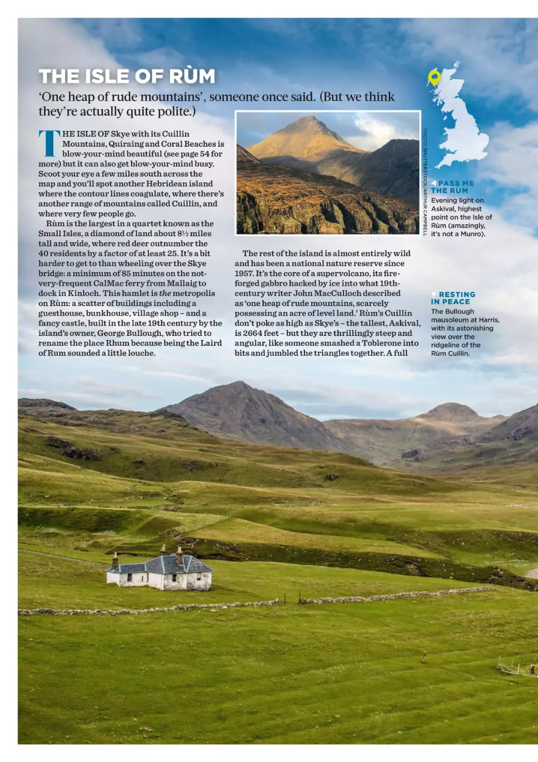
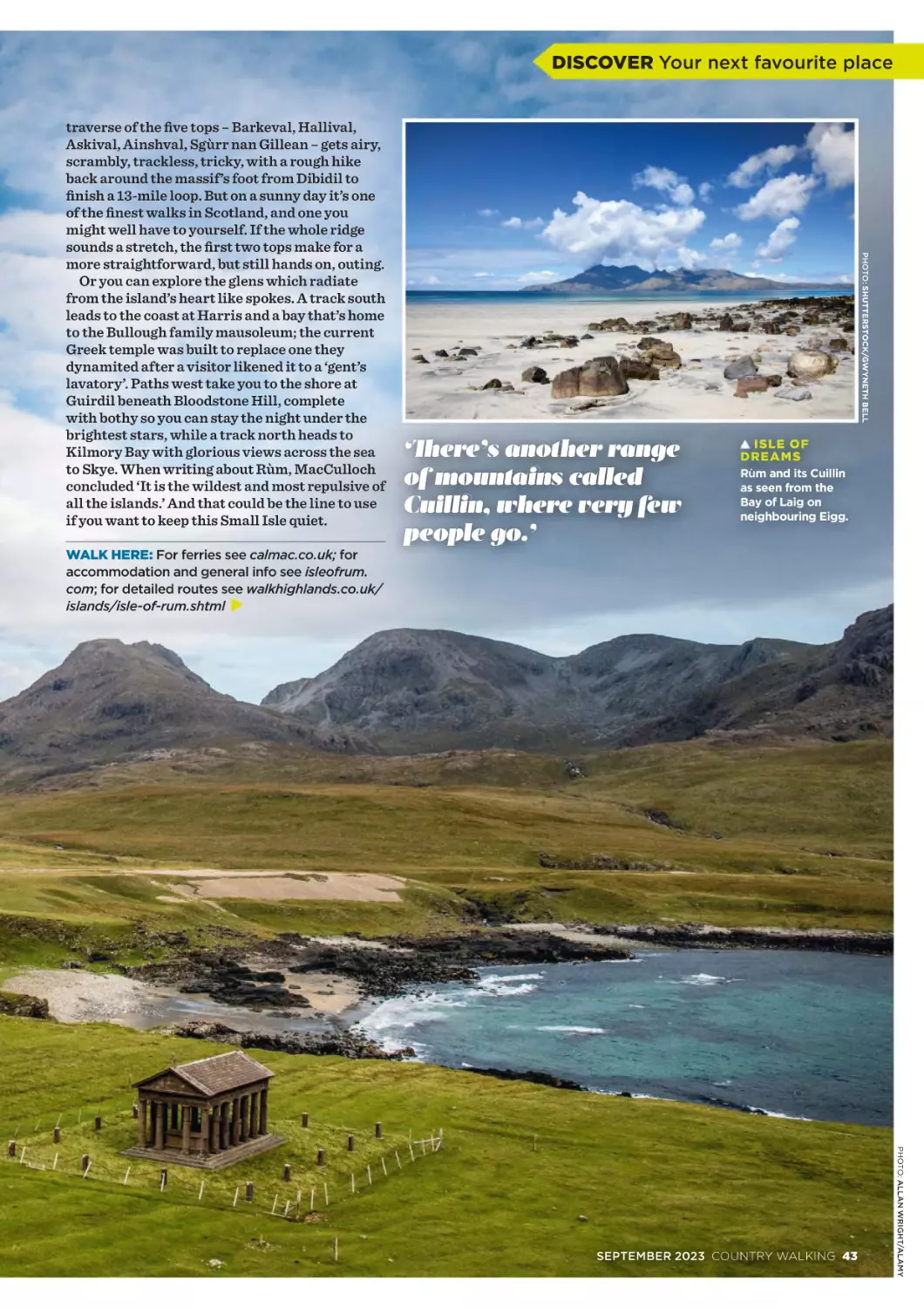
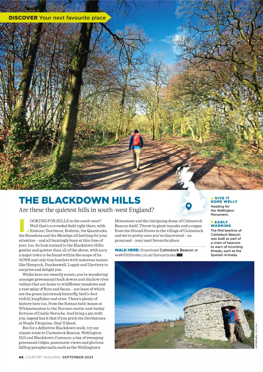
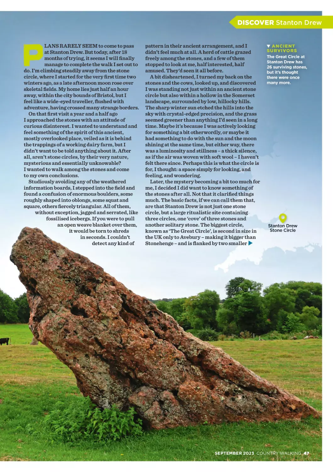
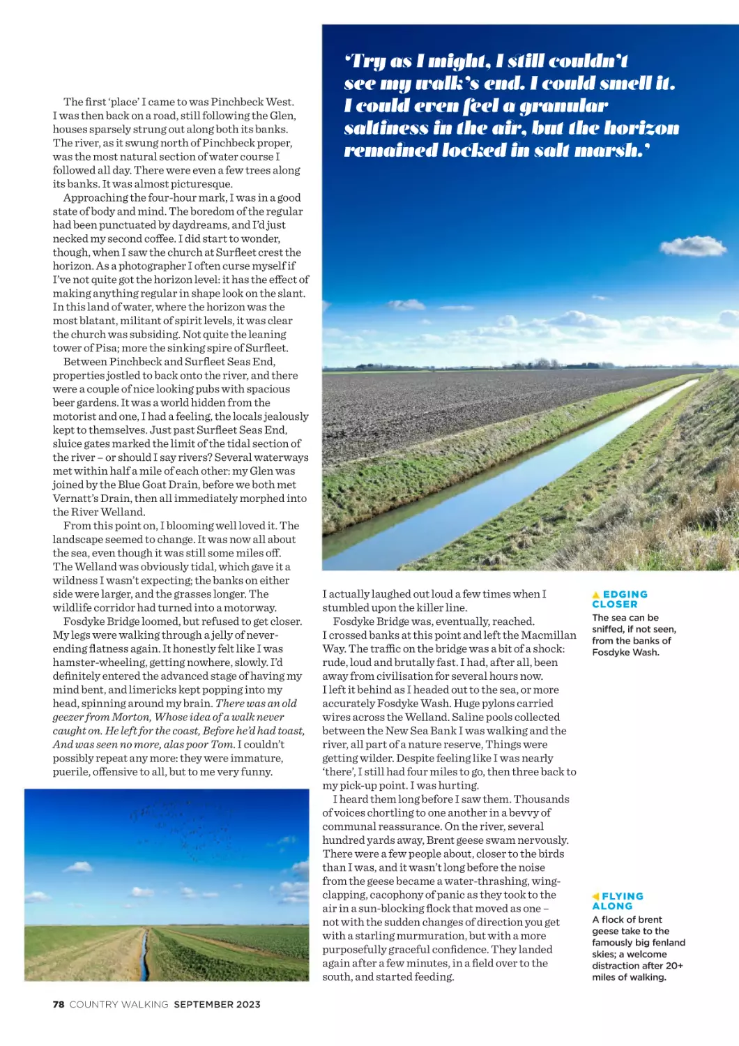
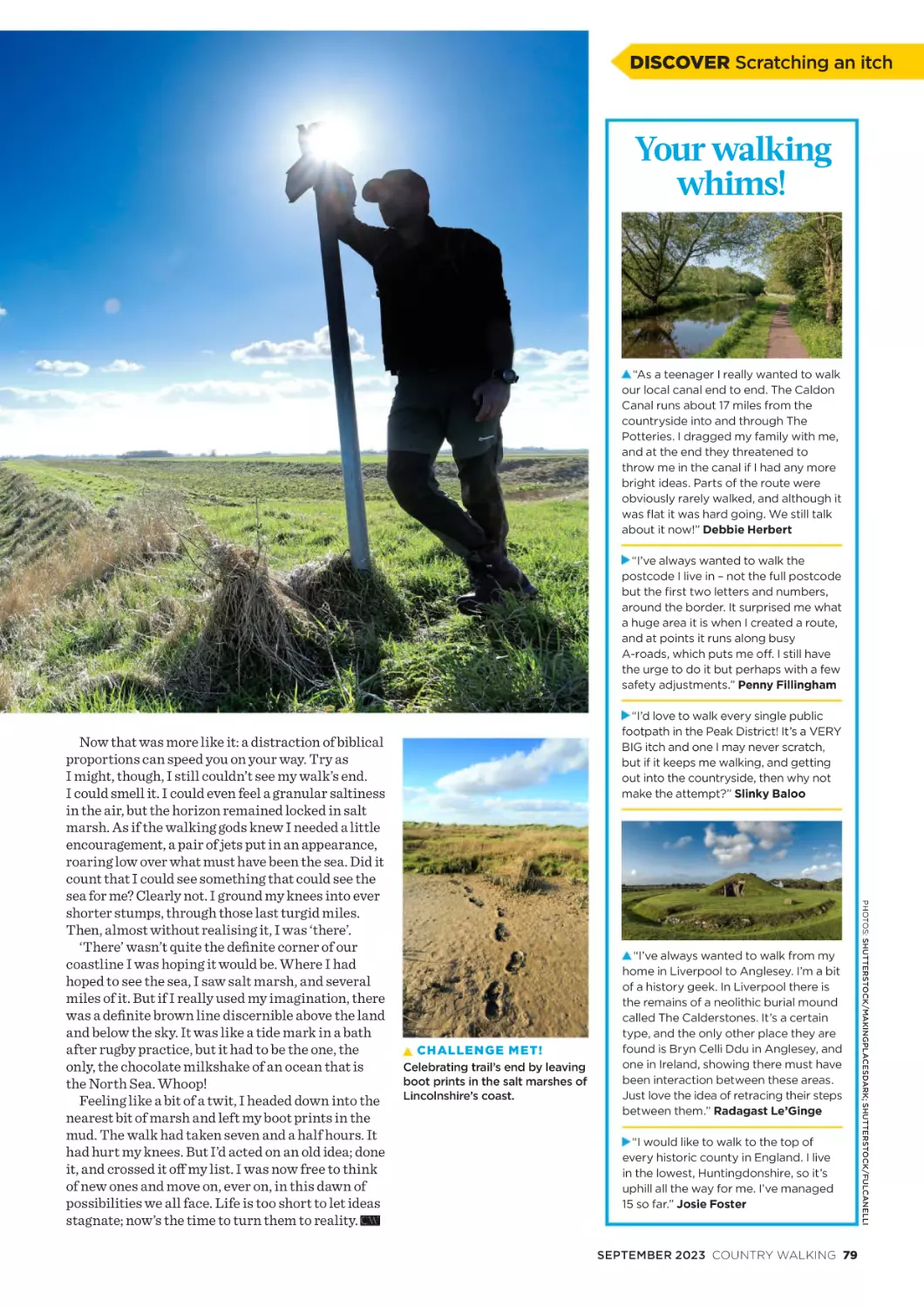
/


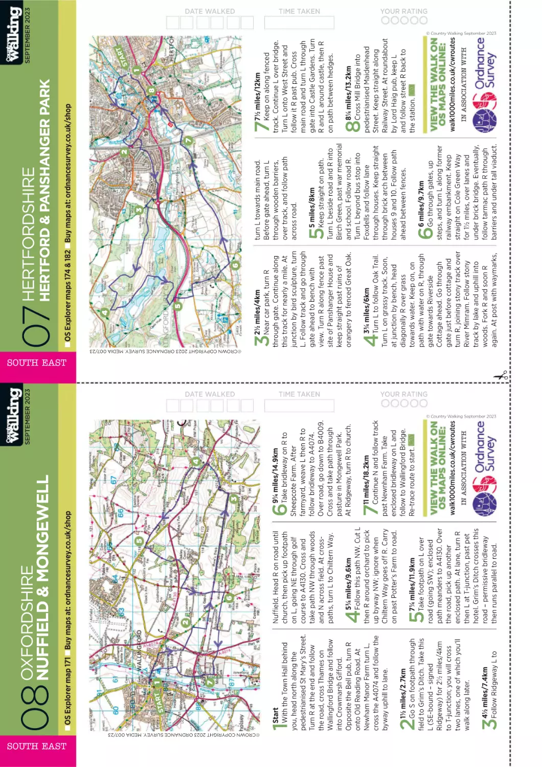
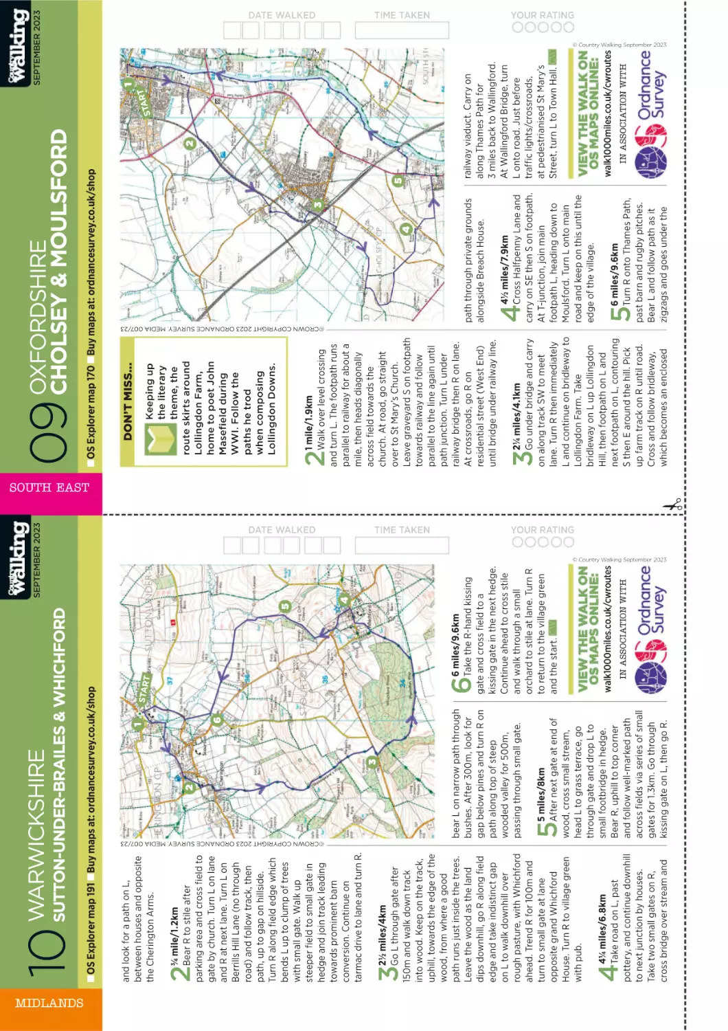

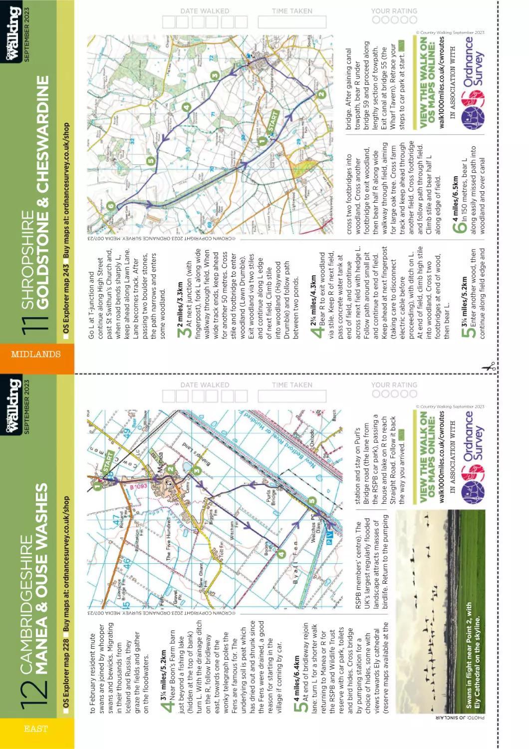


Tags: magazine country walking
Year: 2023


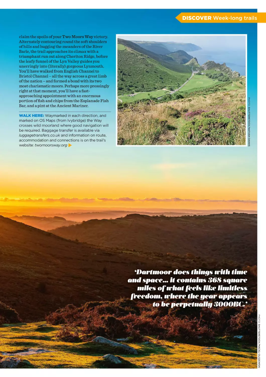
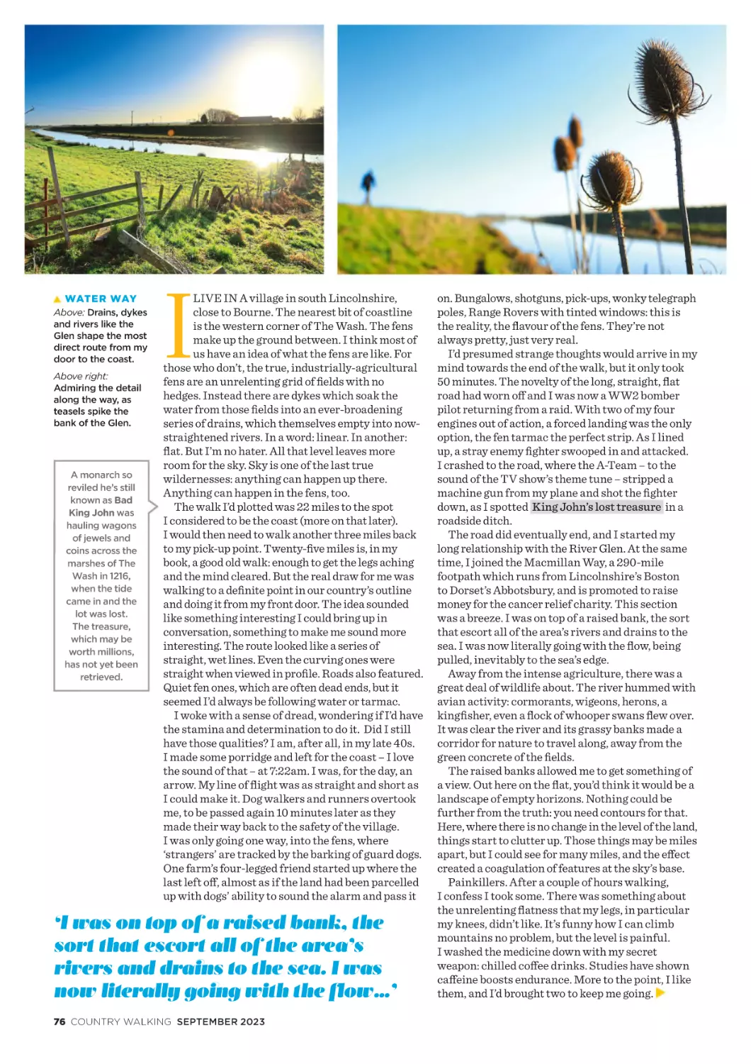
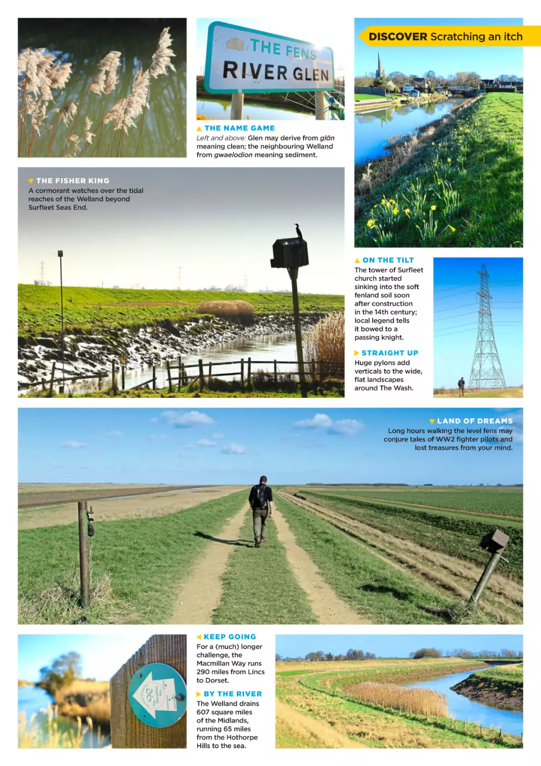
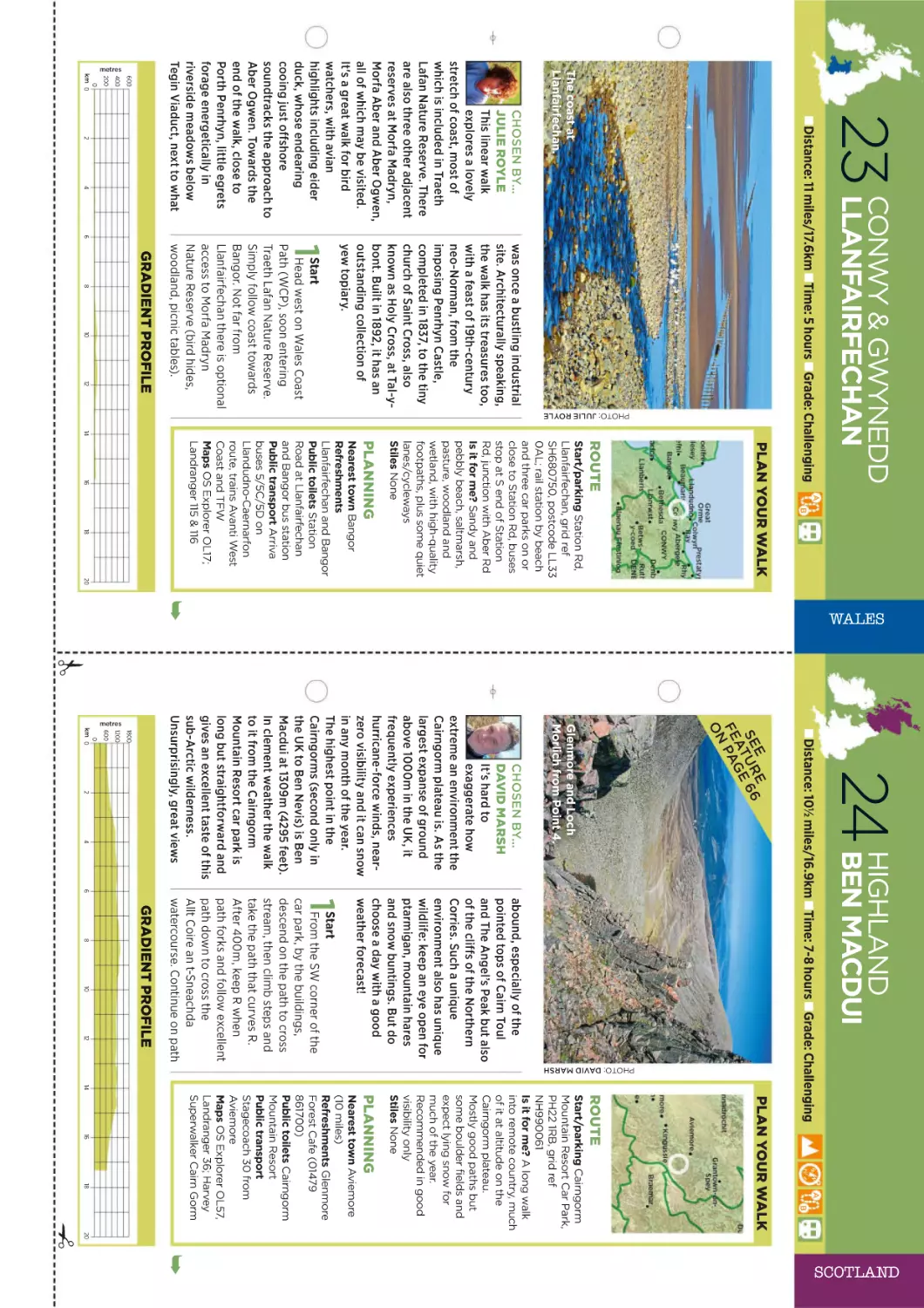
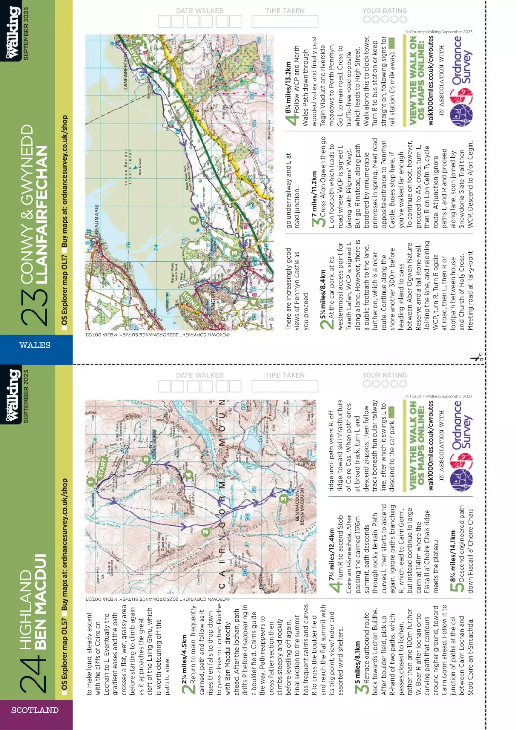
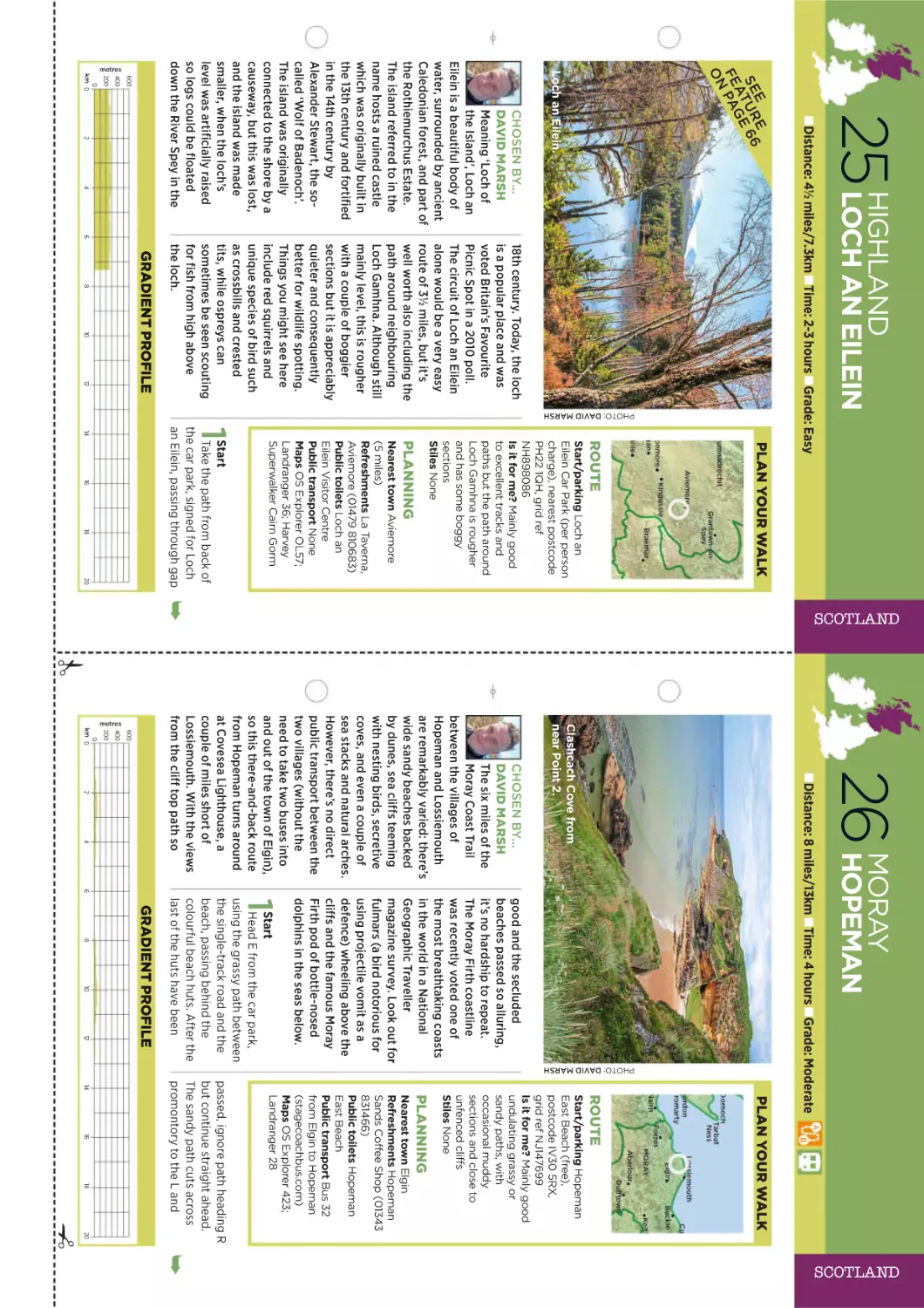
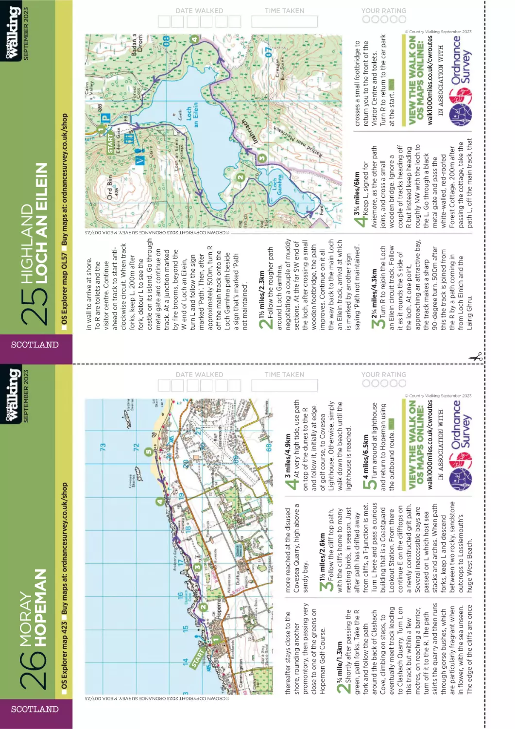
Text
‘Footpaths are our greatest national treasures’
Christopher Somerville: 3 billion years of history on a 1000-mile walk
September
2023
£5.20
WALK 1000 MILES: WALK
YOUR WAY TO BETTER SLEEP
The UK’s best-selling walking magazine
Discover new walking horizons you’ll want to rave about
(but also keep to yourself)
LEGWEAR
TESTED
Best garages
for your flesh
Ferraris
100-MILE
HEROES
Week-long
adventures
because life’s
too short!
UNMISSABLE
SIGHTS
20 must-sees in
Britain’s highest,
wildest National Park
www.livefortheoutdoors.com
FIVE-STARS
AND FREE
SOMERSET’S
SECRET STONES
WALKING
ON A WHIM
The greatest overnight in
Wales is also the cheapest
A five millennia-old puzzle and the
power of a walk and a wonder
Why daft ideas make
for memorable walks
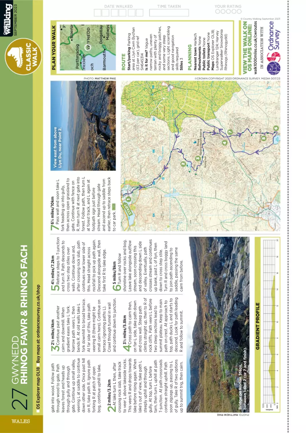
ROUTE CARDS
STEP-BY-STEP
WALKS IN
25 COUNTIES
DEUTER IS FOR
SPRING TIME
TRAIL 28 SL
deutergb.co.uk
#deuterforever
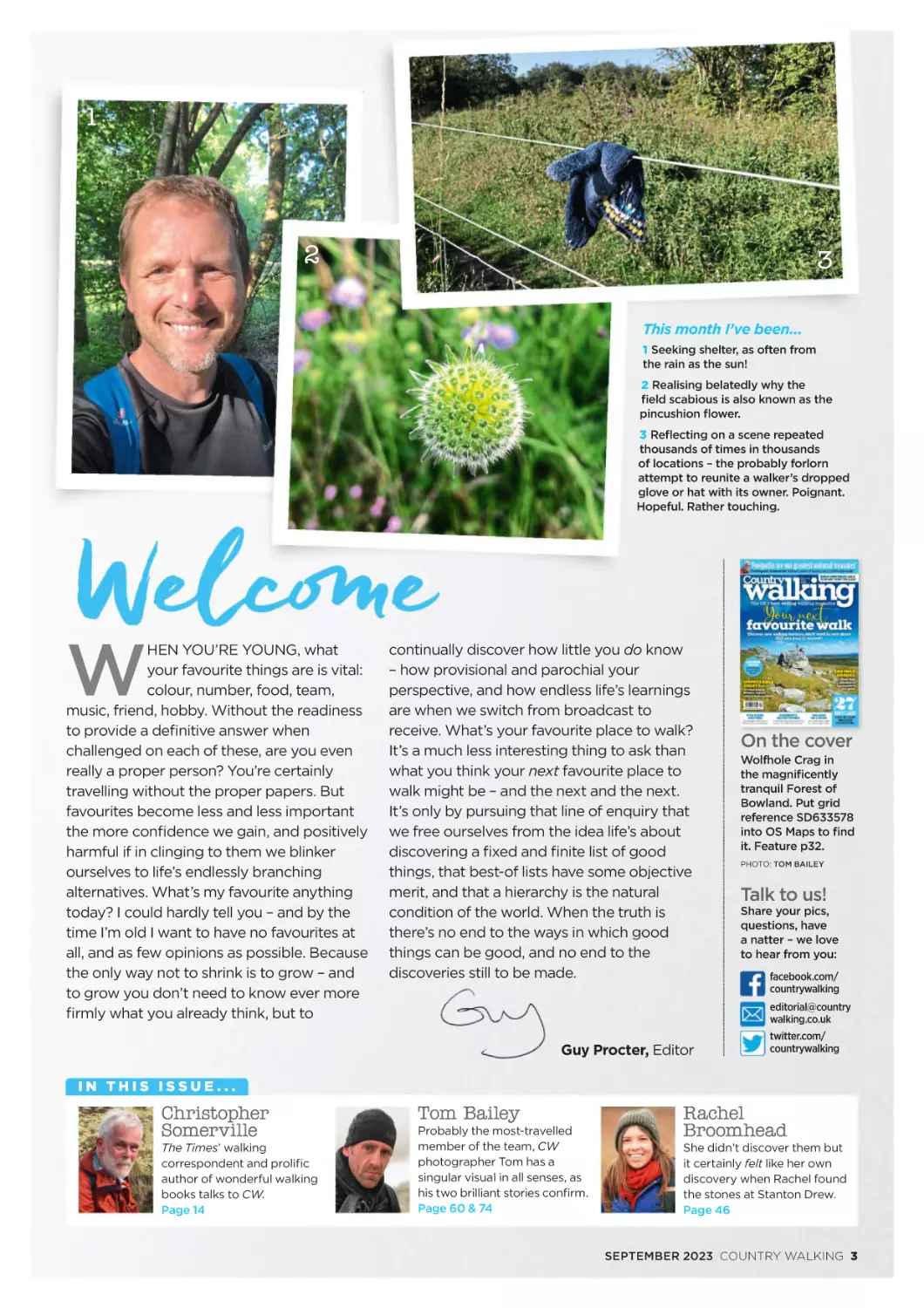
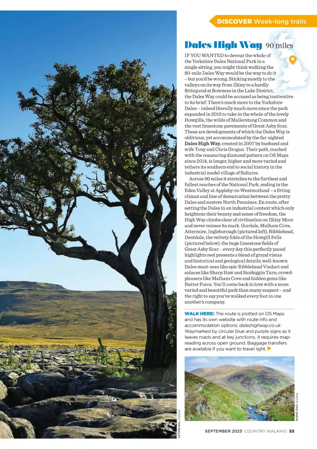
1
2
3
This month I’ve been...
1 Seeking shelter, as often from
the rain as the sun!
2 Realising belatedly why the
field scabious is also known as the
pincushion flower.
3 Reflecting on a scene repeated
thousands of times in thousands
of locations – the probably forlorn
attempt to reunite a walker’s dropped
glove or hat with its owner. Poignant.
Hopeful. Rather touching.
W
HEN YOU’RE YOUNG, what
your favourite things are is vital:
colour, number, food, team,
music, friend, hobby. Without the readiness
to provide a definitive answer when
challenged on each of these, are you even
really a proper person? You’re certainly
travelling without the proper papers. But
favourites become less and less important
the more confidence we gain, and positively
harmful if in clinging to them we blinker
ourselves to life’s endlessly branching
alternatives. What’s my favourite anything
today? I could hardly tell you – and by the
time I’m old I want to have no favourites at
all, and as few opinions as possible. Because
the only way not to shrink is to grow – and
to grow you don’t need to know ever more
firmly what you already think, but to
continually discover how little you do know
– how provisional and parochial your
perspective, and how endless life’s learnings
are when we switch from broadcast to
receive. What’s your favourite place to walk?
It’s a much less interesting thing to ask than
what you think your next favourite place to
walk might be – and the next and the next.
It’s only by pursuing that line of enquiry that
we free ourselves from the idea life’s about
discovering a fixed and finite list of good
things, that best-of lists have some objective
merit, and that a hierarchy is the natural
condition of the world. When the truth is
there’s no end to the ways in which good
things can be good, and no end to the
discoveries still to be made.
On the cover
Wolfhole Crag in
the magnificently
tranquil Forest of
Bowland. Put grid
reference SD633578
into OS Maps to find
it. Feature p32.
PHOTO: TOM BAILEY
Talk to us!
Share your pics,
questions, have
a natter – we love
to hear from you:
facebook.com/
countrywalking
editorial@country
walking.co.uk
Guy Procter, Editor
twitter.com/
countrywalking
IN THIS ISSUE...
Christopher
Somerville
The Times’ walking
correspondent and prolific
author of wonderful walking
books talks to CW.
Page 14
Tom Bailey
Probably the most-travelled
member of the team, CW
photographer Tom has a
singular visual in all senses, as
his two brilliant stories confirm.
Page 60 & 74
Rachel
Broomhead
She didn’t discover them but
it certainly felt like her own
discovery when Rachel found
the stones at Stanton Drew.
Page 46
SEPTEMBER 2023 COUNTRY WALKING 3
CONTENTS SEPTEMBER 2023
Could this be your
new favourite
walk? Forest of
Bowland p32
FEATURES
32
38
Your next favourite place
Just when you think the British
Isles can’t surprise you any more,
they always do. Welcome to a
place quieter than, and quite
unlike, any other.
More off-the-beaten track
places to walk
It’s not that we want to get away
from people – well, not all the
time, anyway.
46
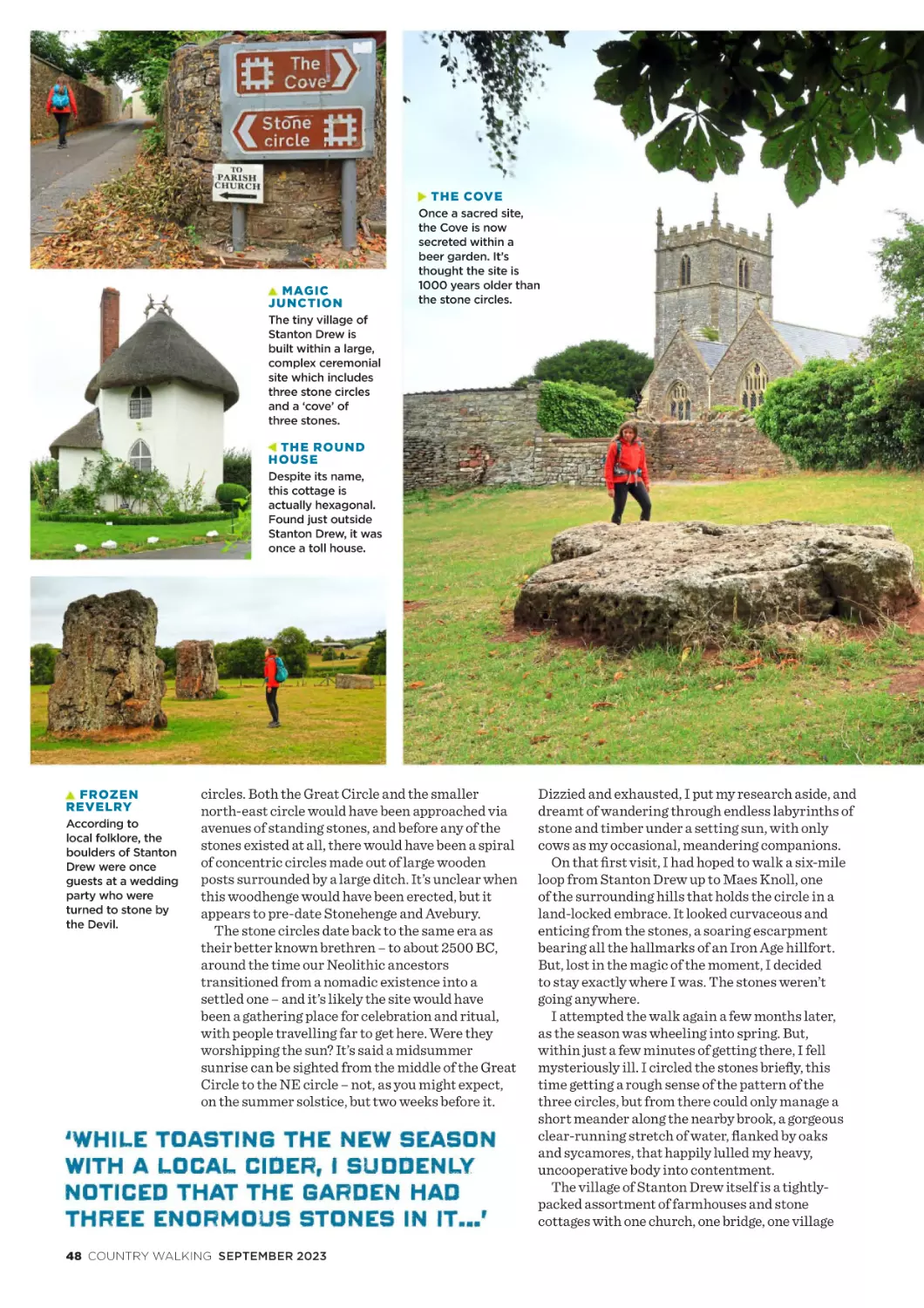
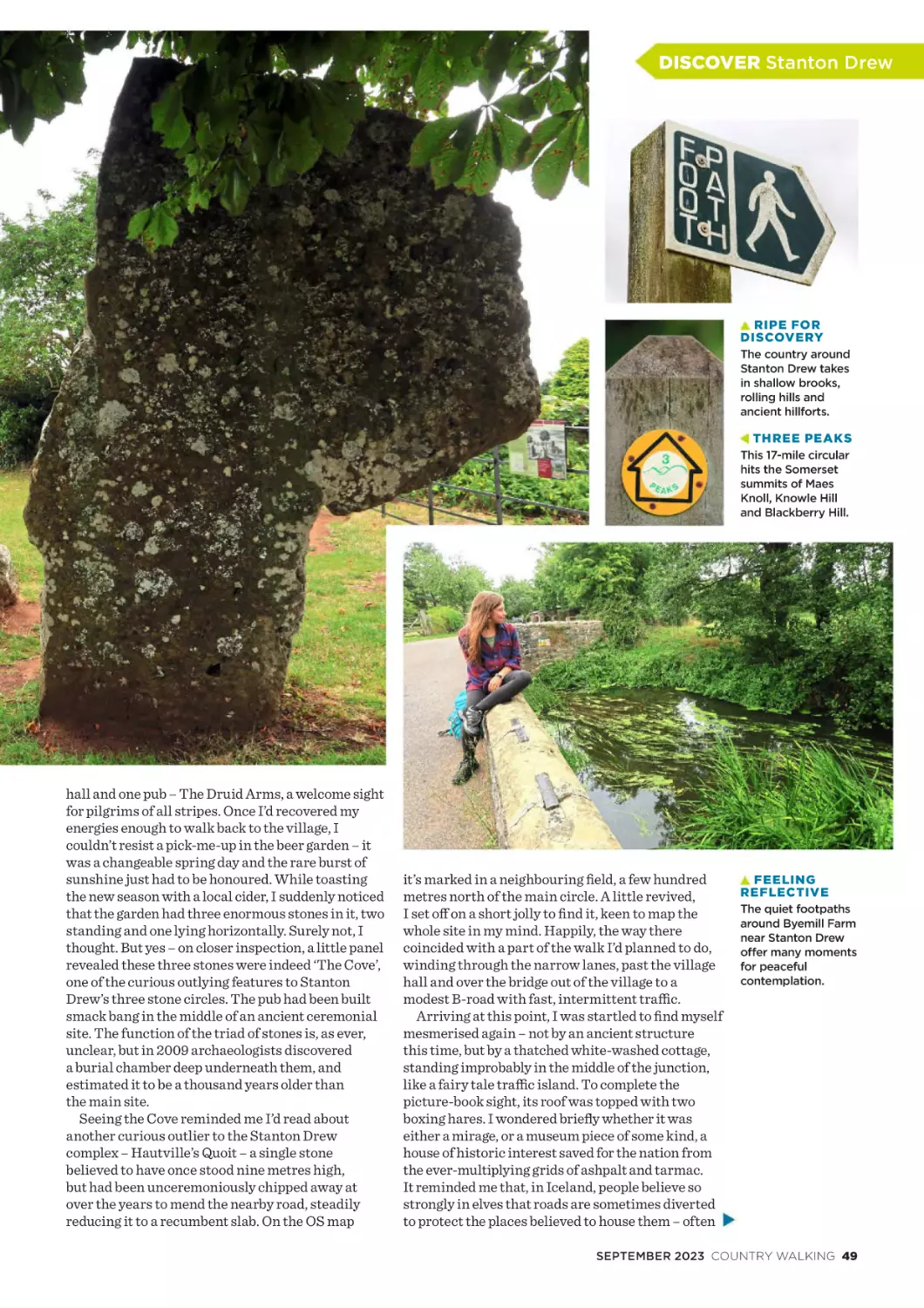
Running Rings Around
the Heart
There are world famous stone
circles, and there are stone circles
the world seems to have forgotten.
4 COUNTRY WALKING SEPTEMBER 2023
COVE R STORIES
52
60
66
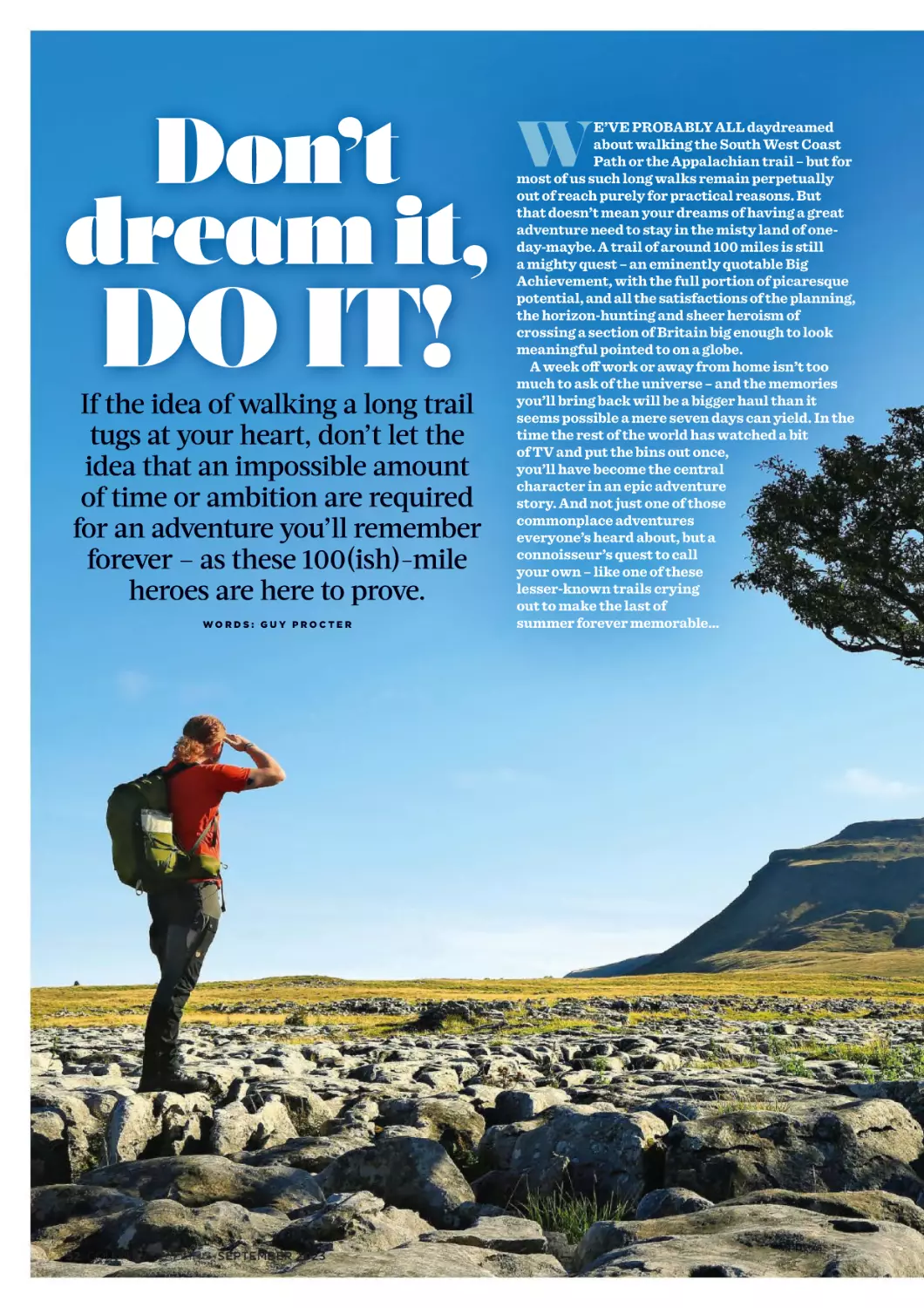
Don’t dream it, do it!
If the idea of walking a long trail
tugs at your heart, don’t let the idea
it requires an impossible amount of
time or ambition put you off...
20 Walk1000miles & sleep
32 Your next favourite walk
80 Legwear tested
66 Unmissable sights
52 100-mile heroes
Welcome to the dreamhouse
60 Five-stars and free
We’d all like a little place in the
country – we’ve all got one, too.
46 Somerset’s secret stones
The Cairngorms National
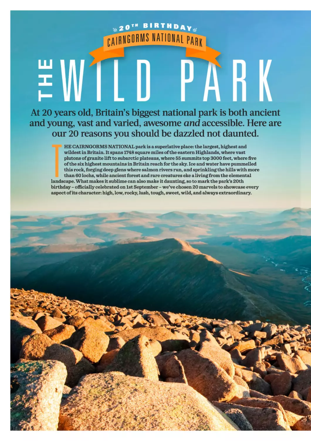
Park at 20
Ancient and young, vast and varied,
awesome and accessible.
74
14 Christopher Somerville
I woke up one morning
and walked to the coast
The power of walking on a whim.
‘Tucked away
is a green space
that these old and
new EastEnders
clearly love.’
STUART MACONIE P31
Make your walking
dream come true:
Hike to the sea p74
27 NEW ROUTES
Get out more
this month!
Step-by-step directions
and Ordnance Survey
maps for 27 walks
all over the country.
TURN OVER FOR MORE…
REGULARS
11
14
The View
PLUS …
A new coast to coast, a Black Mirror
location scouted and the biggest
ever GPS doodles.
8
87 Quizzes and prize crossword
Interview:
Christopher Somerville
88 Classified directory
121 Our routes, your walks
Three billion years in 1000 miles.
18
What a house! What a view!
Yours for free: Bothying p60
Special subscription offer
29 Where’s Kes?
122 Footnotes
Walking Weekend
123 In next month’s issue
Ready-made plans for two days
waking in and around Wallingford.
123 Contact Country Walking
20
#Walk1000miles
26
Your letters, emails & posts
31
Column: Stuart Maconie
Legwear
tested p80
How it feels hitting major
milestones, sleep and science.
Special places, sea to summit
and your latest lovely views.
Hours of boredom punctuated
by moments of walking pleasure.
REVIEWS
Go wild in Britain’s biggest
park: The Cairngorms p66
GET
BENEFITS
BECOME A
MEMBER
PAGE 8
80
Walking legwear tested
Trousers, leggings and shorts
tested: because you need a
favourite pair.
THIS ISSUE WAS BROUGHT TO YOU BY…
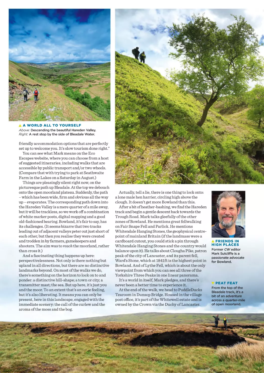
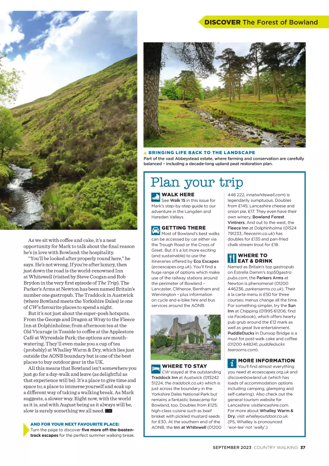
Chink of gate-latches descending, crunch of stony path compacting, clack
of scree repositioning, psst of bottle opening, warmth from a sun-warmed
stone wall, plaintive cry of curlew, spongy wading of heather, slap of hand on
trig point, feel of palm-size pinecone and the prospect of a post-walk pint.
SEPTEMBER 2023 COUNTRY WALKING 5
CUT-OUT
AND-KEEP
ROUTES
Highlights from the 27 fantastic walks in this issue…
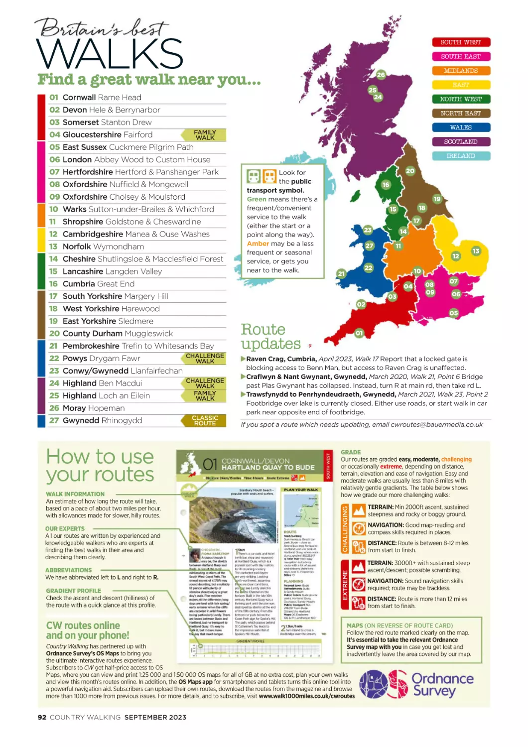
SOUTH WEST
SOUTH EAST
OUR POCKET-SIZED
ROUTE CARDS
START ON
PAGE 91
✁
Find a great
walk near you!
MIDLANDS
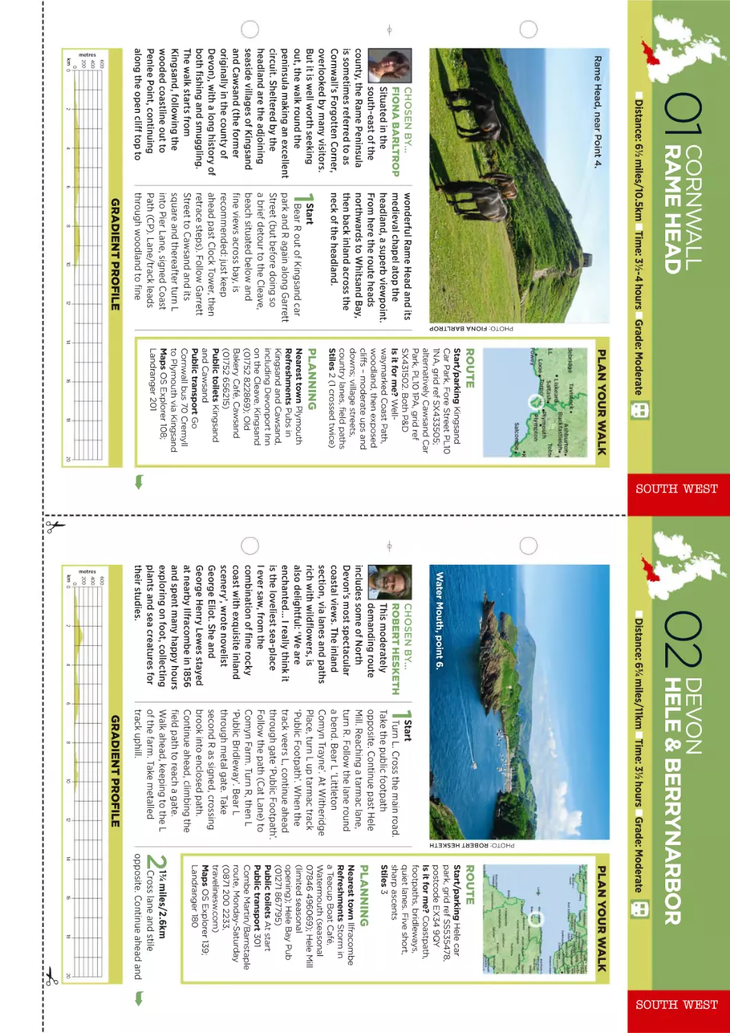
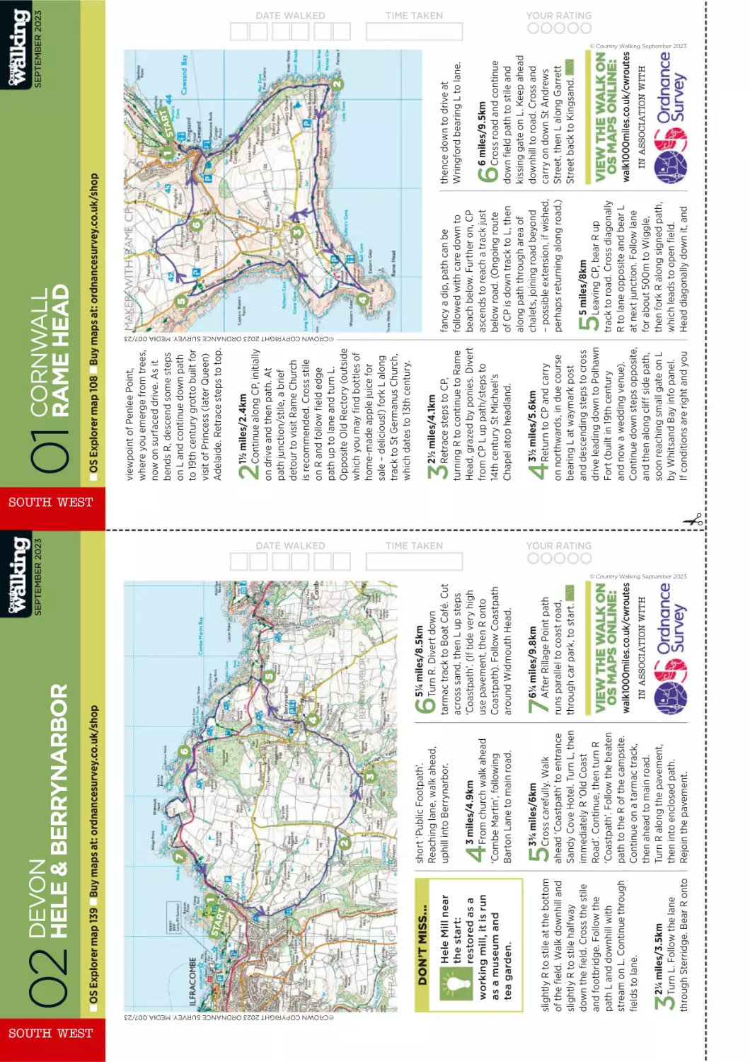
Hele & Berrynarbor, Devon
Hertford, Hertfordshire
Cheswardine, Shropshire
“I really think it is the loveliest sea-place
I ever saw,” said novelist George Eliot
about this part of North Devon.
TURN TO WALK 2
Walk among the ancient trees in
Panshanger Park (rumour has it one
of them was planted by Elizabeth I).
TURN TO WALK 7
See the handiwork of those who used
picks and shovels to hack through rock
to clear the way for this beautiful canal.
TURN TO WALK 11
EAST
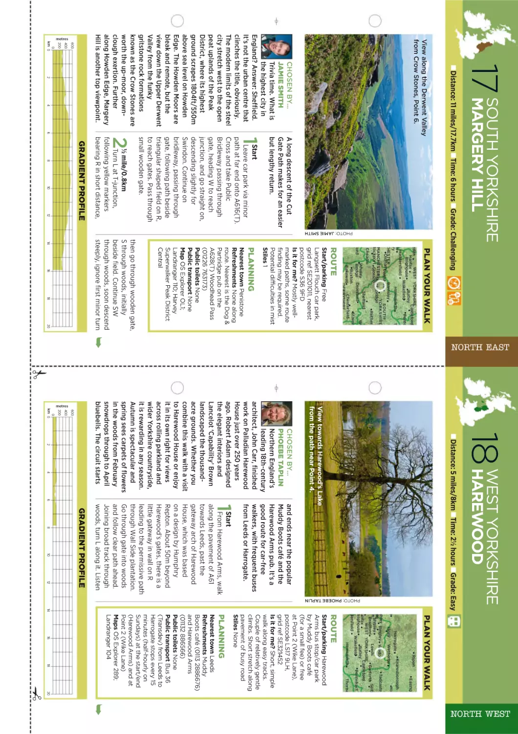
NORTH WEST
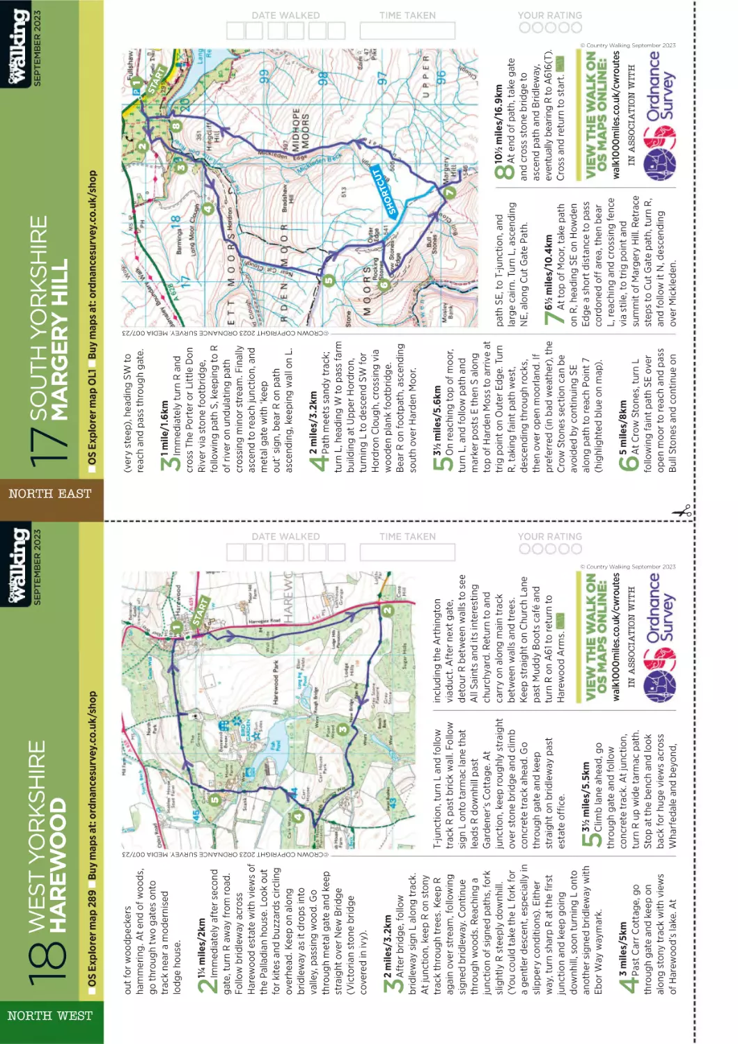
NORTH EAST
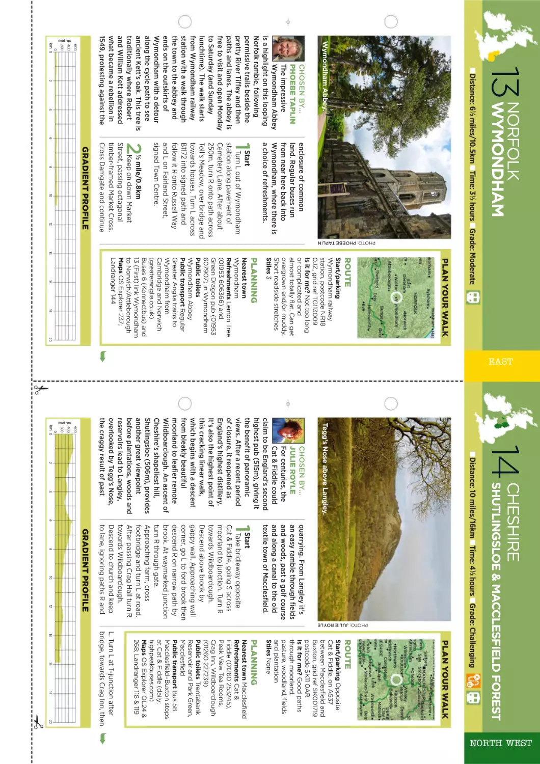
Wymondham, Norfolk
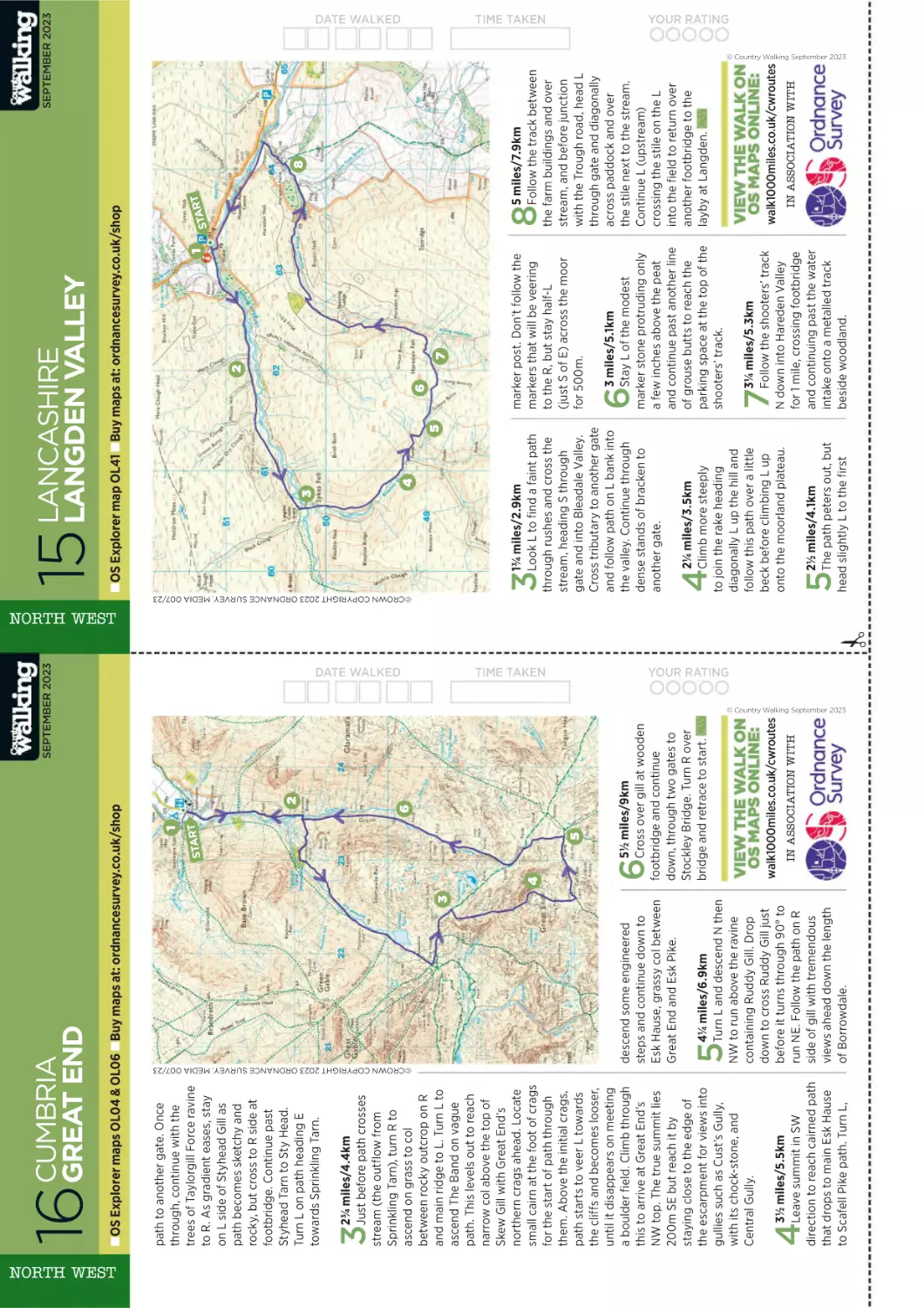
Great End, Cumbria
Muggleswick, Co Durham
Visit a 900-year-old abbey, plus an
ancient tree that’s synonymous with
a notorious 16th-century rebellion.
TURN TO WALK 13
Discover why this Lake District fell is
far too good to be merely a warm-up
act for Scafell Pike.
TURN TO WALK 16
Embark on a moorland yomp from a
peaceful village whose association with
Harry Potter took the locals by surprise.
TURN TO WALK 20
WALES
SCOTLAND
CLASSIC
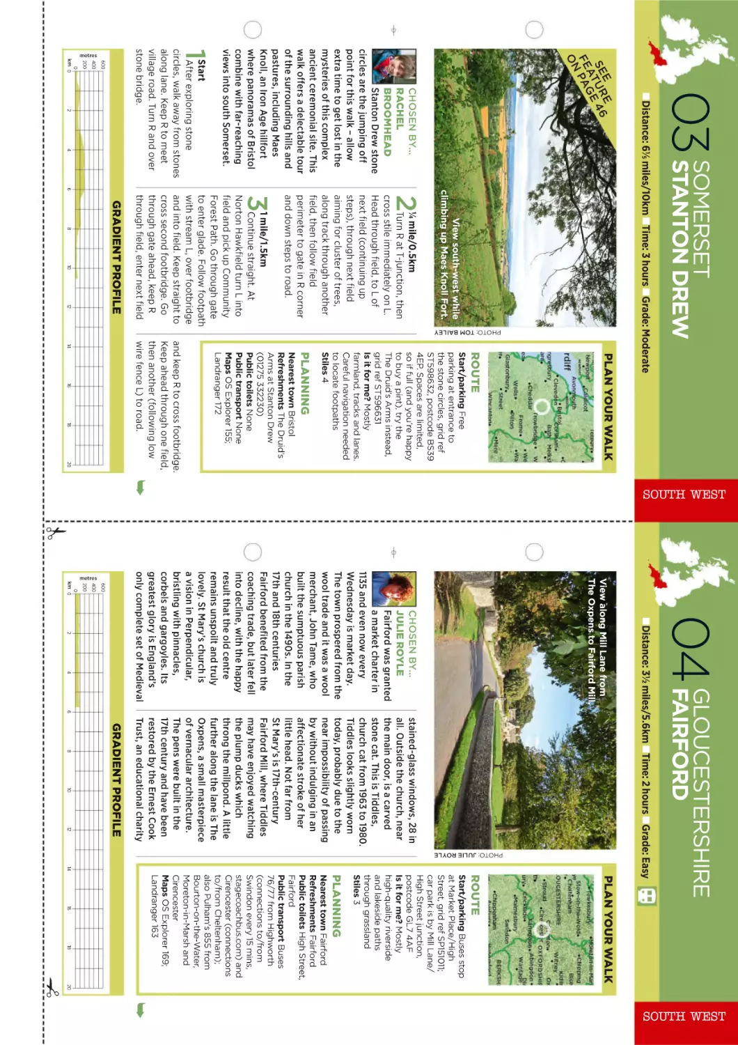
Drygarn Fawr, Powys
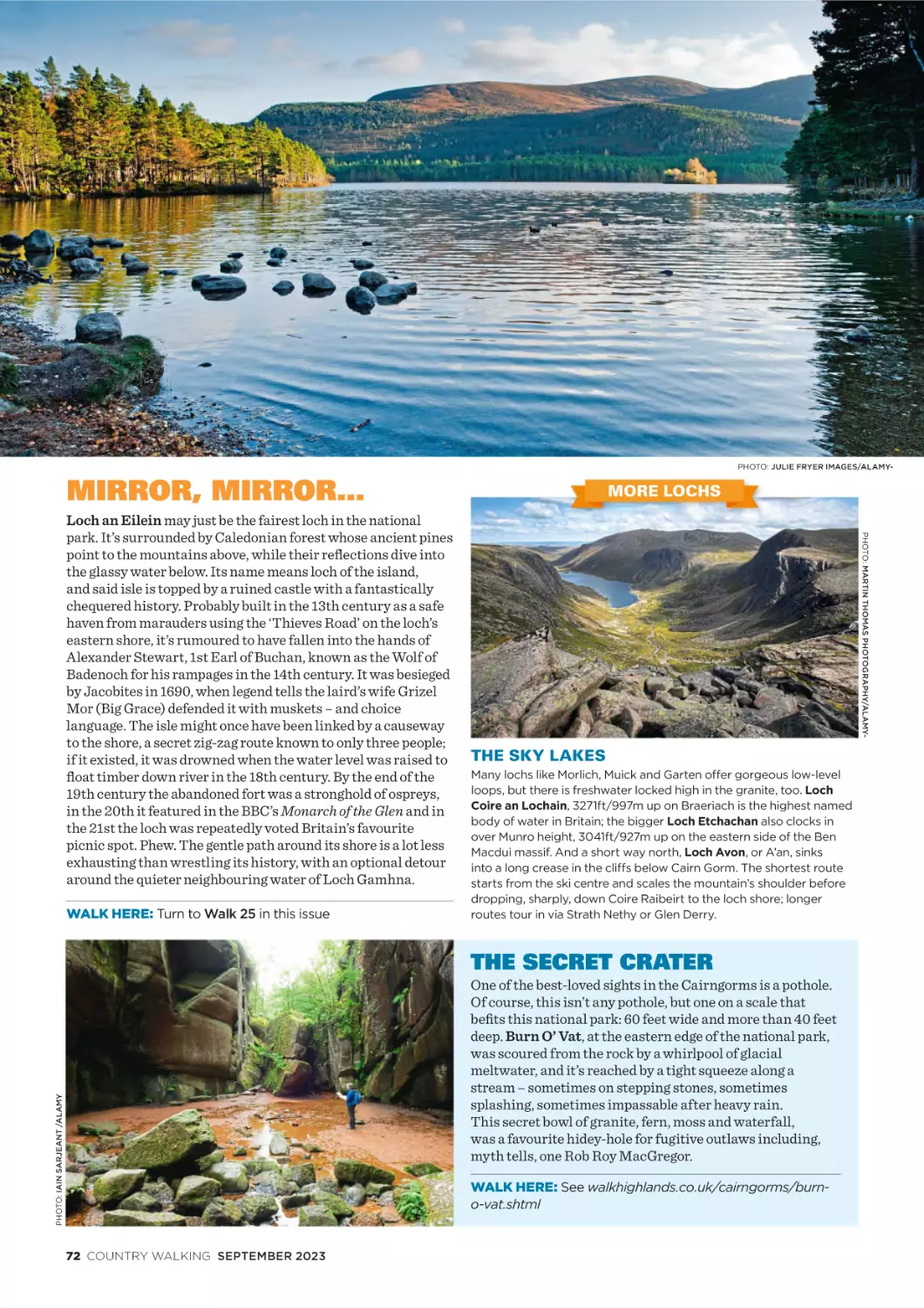
Loch an Eilein, Highland
Rhinogydd, Gwynedd
Venture to this lonely hill on a lonely
range in the wild and magnificent
Green Desert of Wales.
TURN TO WALK 22
Enjoy a family walk to two gorgeous
lochs, ancient Caledonian forest and one
of Britain’s best picnic spots (officially!).
TURN TO WALK 25
Test your mettle on the two most
thrilling and iconic summits on Wales’
toughest mountain range.
TURN TO WALK 27
6 COUNTRY WALKING SEPTEMBER 2023
With new routes in every issue
PLUS half price OS Maps, you’ll never
be short of inspiration for where
to walk this summer!
Join today 01858 438884 Quote CWAA
TERMS & CONDITIONS: The 3 for £10 trial offer applies to a Print + Digital Package Membership on a monthly recurring basis and will auto-renew to
£5.20 after the initial 3 months. Direct Debit payments will continue to be taken unless you tell us otherwise. Print editions will start with the next available
issue. Offer closes 13/09/23 and cannot be used in conjunction with any other offer. Cost from landlines for 01 numbers per minute is (approx.) 2p to 10p.
3
MONTHS
FOR ONLY
£10
PRINT PLUS
MEMBERSHIP
3 issues for £10
then £5.20 every month
by recurring payment
• 13 print editions delivered
free to your door (UK only)
• Digital edition access
via Member-only app
and website
• Past editions archive and
selected audio articles
• Members-only Rewards,
discounts and prizes
• Monthly editor’s
e-newsletter
• 50% off OS Maps Premium
Membership
We believe walking is
the key to unlocking
a world of wonder,
happiness, and
health, and it’s a
vision we’re thrilled
to share with tens of
thousands of readers
with whom we love
to correspond. Join
their number and
become a Country
Walking Member
and you’ll pay less
than the shop price,
qualify for a halfprice subscription
to the wonderful OS
Maps service, and
be the first to hear
from us every month.
Plus, we’ll be adding
more rewards to your
Country Walking
Membership as the
months go by.
Guy Procter, editor
greatmagazines.co.uk/countrywalking
Scan on your smartphone
Cost from mobiles per minute (approx.) 10p to 40p, but varies depending on the geographical location. You may get free calls to some numbers as
part of your call package – please check with your phone provider. Order lines open 8am-9.30pm (Mon-Fri), 8am-4pm (Sat). Calls may be monitored
or recorded for training purposes. For general terms and conditions, please visit greatmagazines.co.uk/offer-terms-and-conditions
SIGHTS | SOUNDS | WONDERS | IDEAS | COOL STUFF
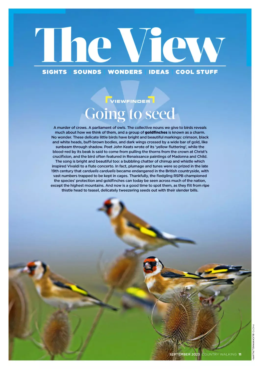
Going to seed
A murder
d r of crrow
owss. A par
arli
liam
am
men
entt o
off owl
w s. The
he collle
ect
ctiv
ive no
n un
ns we giv
ive
e to
to bir
irds
ds rev
evea
als
much
mu
much
h aboutt how
ow we th
thin
ink
k of them,
m and
nd a gro
roup
p of go
g ld
ldfinch
c es iss kn
now
wn as a cha
h rrm
m.
No
o won
onde
der.
r. The
hese
se
e del
elic
ic
cat
ate
e li
litt
ttle
tt
le
e bir
irds
ds hav
ave
e brrig
ght and
nd bea
eaut
uttiifful
ul mar
arki
king
ngs:
s: cri
rims
m on
ms
on, bllac
ack
k
and wh
an
whit
i eh
he
eads,
ad
ds, buff
ff-b
-b
bro
rown
w bodie
wn
od
die
ies,
s, and dar
a k wi
w ng
ngss cr
c os
osse
ed by a wide
id
de ba
barr o
off gol
o d,
d, lik
ke
sunb
su
nb
bea
eam
m thro
thro
th
oug
ugh
h sh
had
adow
o . Poet
Poet Joh
hn Ke
Keats wr
wrot
ote of its
t ‘ye
yell
llow
ow flutte
uttte
teri
riing
ring
g’,, whi
h le the
bloo
bloo
oodd-re
re
ed by its
t bea
ak is sai
aid
d to
o com
ome
e fr
fo
om
m pulli
ling
ng the
e tho
orn
rns from the
h cro
he
row
wn at Ch
wn
hrist
riist’s
cruc
cr
ucifixi
x on
n, an
and
d the bird
rd
d offtten fea
e tu
t re
red
d in
n Ren
e aiiss
s an
ance
ce painttin
i gs of Mado
onna
nn
na an
and Ch
hild.
The so
Th
song
ng is br
brig
ig
ghtt and
d bea
eaut
uttif
i ull too
o: a bu
bubb
bb
b
bli
ling
ng cha
hatt
tter
er of chirrup an
a d wh
histl
is
stl
t e wh
whic
ich
h
insp
in
spir
ired
ed Viiv
val
a dii to a flu
fl te
te con
once
cert
ce
rto.
rt
o. In fa
fact,
t pl
p um
mag
ge and
an
nd tu
tune
ness we
were so prized
ed in th
he late
te
19th
19
th cen
ntu
ury tha
at ca
card
rdue
rd
ueli
ue
liss ca
li
card
rd
due
ueli
liis bec
ecam
ame
am
e en
enda
dang
da
ngerre
ed
d in tth
he Br
B ittish countr
trys
ysid
id
de,
e, wit
ith
h
v st num
va
umbe
be
ers tra
rapp
p ed to be
pp
be kep
e t in
n cag
ages
es.. Th
es
Than
ankf
an
kful
kf
u ly
ul
y, the fle
fl dg
dgling
g RSP
S B cham
a pi
pion
oned
on
ed
the
th
e sp
spec
ecie
ec
ies’
ie
s’ pro
rote
tecttio
te
ion
n and go
g ldfin
nch
hes can
a tod
day be se
seen
en acrros
oss much
mu
uch
c of the na
n tion
on
n,
exce
ex
cept
pt the hig
ighe
he
est mount
ntains. And now iss a good
d ti
t me
m to spott the
hem,
m, as th
they flit from
m ri
ripe
pe
this
th
istl
is
t e he
tl
head
ad to te
teas
assel
e , de
deliica
ate
t ly
y twe
weez
ezer
ez
erin
rin
i g se
seed
edss ou
ed
o t wi
with
th the
heir sle
l nderr bil
ills
ls.
s.
PHOTO: BLICKWINKEL/ALAMY-
SEPTEMBER 2023 COUNTRY WALKING 11
The View
1
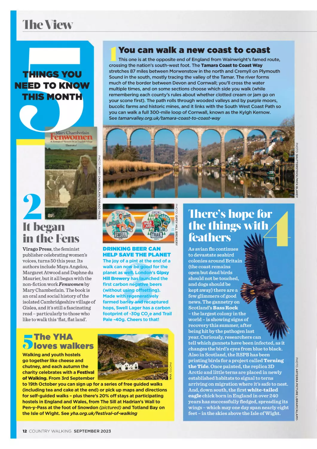
This one is at the opposite end of England from Wainwright’s famed route,
crossing the nation’s south-west foot. The Tamara Coast to Coast Way
stretches 87 miles between Morwenstow in the north and Cremyll on Plymouth
Sound in the south, mostly tracing the valley of the Tamar. The river forms
much of the border between Devon and Cornwall; you’ll cross the water
multiple times, and on some sections choose which side you walk (while
remembering each county’s rules about whether clotted cream or jam go on
your scone first). The path rolls through wooded valleys and by purple moors,
bucolic farms and historic mines, and it links with the South West Coast Path so
you can walk a full 300-mile loop of Cornwall, known as the Kylgh Kernow.
See tamarvalley.org.uk/tamara-coast-to-coast-way
THINGS YOU
NEED TO KNOW
THIS MONTH
PHOTO: SHUTTERSTOCK/MICK BLAKEY
PHOTO: GIPSY HILL BREWERY
PHOTO: MARY CHAMBERLAIN/VIRAGO PRESS
2
You can walk a new coast to coast
It began
in the Fens
Virago Press, the feminist
publisher celebrating women’s
voices, turns 50 this year. Its
authors include Maya Angelou,
Margaret Atwood and Daphne du
Maurier, but it all began with the
non-fiction work Fenwomen by
Mary Chamberlain. The book is
an oral and social history of the
isolated Cambridgeshire village of
Gislea, and it’s still a fascinating
read – particularly to those who
like to walk this ‘flat, flat land’.
5
DRINKING BEER CAN
HELP SAVE THE PLANET
The joy of a pint at the end of a
walk can now be good for the
planet as well. London’s Gipsy
Hill Brewery has launched the
first carbon negative beers
(without using offsetting).
Made with regeneratively
farmed barley and recaptured
hops, Swell Lager has a carbon
footprint of -30g CO2e and Trail
Pale -40g. Cheers to that!
The YHA
loves walkers
As avian flu continues
to devastate seabird
colonies around Britain
(the coast remains
open but dead birds
should not be touched,
and dogs should be
kept away) there are a
few glimmers of good
news. The gannetry on
Scotland’s Bass Rock
– the largest colony in the
world – is showing signs of
recovery this summer, after
being hit by the pathogen last
year. Curiously, researchers can
tell which gannets have been infected, as it
changes the bird’s eyes from blue to black.
Also in Scotland, the RSPB has been
printing birds for a project called Terning
the Tide. Once painted, the replica 3D
Arctic and little terns are placed in newly
established habitats to signal to terns
arriving on migration where it’s safe to nest.
And, down south, the first white-tailed
eagle chick born in England in over 240
years has successfully fledged, spreading its
wings – which may one day span nearly eight
feet – in the skies above the Isle of Wight.
PHOTO: ARTERRA PICTURE LIBRARY/ALAMY-
12 COUNTRY WALKING SEPTEMBER 2023
PHOTO: YHA
Walking and youth hostels
go together like cheese and
chutney, and each autumn the
charity celebrates with a Festival
of Walking. From 3rd September
to 19th October you can sign up for a series of free guided walks
(including tea and cake at the end) or pick up maps and directions
for self-guided walks – plus there’s 20% off stays at participating
hostels in England and Wales, from The Sill at Hadrian’s Wall to
Pen-y-Pass at the foot of Snowdon (pictured) and Totland Bay on
the Isle of Wight. See yha.org.uk/festival-of-walking
There’s hope for
the things with
feathers
CAUGHT OUR EYE
Footmarks by Jim Leary
TH E WA L K I N G POLL
We asked…
You are granted
one of the following
wishes. Which do
you go for?
Acorns and
conkers are
actually Cadbury
Mini Eggs
You have
the sense of
direction of a
homing pigeon
A rucksack which, like
Mary Poppins’ bag, can
contain anything and never
gets any heavier
PHOTOS: YASUSHI TAKAHASHI
Archaeology can seem a dry study of
‘cold hearths and colder graves’ but this
Journey into our Restless Past reanimates
history. Humanity has always been on
the move – leaving prints on the coast of
north Norfolk a million years ago, forging trackways,
holloways and roads – and Leary guides us on a
thought-provoking, often emotionally moving, journey
around the UK, and further afield. ‘By following
footsteps, we find the texture of paths and the places
they connect. We hear settlements alive and full of busy
people; the hubbub of business, the shouts of street
vendors, the din from the inns. We see gossip spreading
along lanes and alleys – these were the conduits where
real life happened.’ £18.99, iconbooks.com
Yasushi Takahashi took a huge step up
from dropping down on one knee and
proposed to his girlfriend by using GPS
to write ‘Marry Me’ across the islands of Japan, finishing
with an arrow-pierced heart for good measure. He won
a yes from Natsuki and a Guinness World Record for the
largest GPS drawing (individual), covering the 7163.67km
by car, ferry, bicycle – and on foot. The artist, also known
as Yassan, has now created 2000 GPS works in 24
countries, clocking up more than 100,000 kilometres,
including hiking 1230.5 km to create his largest walking
picture, drawing the face of Hatsune Miku, a symbol of
otaku culture. ‘I see GPS art
as a way to experience local
history and culture,’ he says
on his website. ‘By moving,
I draw something, and at
the same time, I touch the
historical culture and deepen
my understanding of the
region.’ See gpsdrawing.info
2%
4%
24%
LO C A T IO N S C O U T
Free rail and bus travel
for you + 1 forever
It only ever rained at night
Black Mirror (Netflix)
31%
The sixth season of Charlie Brooker’s dystopian anthology
was released this summer and, for the first time, an episode
was set in Scotland. Loch Henry is a grisly tale of true crime
in the Highlands, probing our ‘rubbernecker’ obsession and
how violence is often packaged in beauty – inspired by a
documentary Brooker saw with ‘millions of drone shots over
lochs and forests. Oddly, despite this horrible story, the stunning
landscapes were so beautiful we found ourselves Googling
where it was and wanting to go on holiday there.’ Scenes for
Loch Henry were shot at 18 different locations, including the
outside of the pub at The George Hotel at Inverary on Loch
Fyne, the inside at Arrochar’s Village Inn, and the long,
luscious panoramas of the titular water at Loch Leven,
with the conical Pap of Glencoe a distinctive landmark.
39%
HOW T O
BEAT BLISTERS
PHOTO: SHUTTERSTOCK/TAKING IN THE SIGHTS
PHOTO: TOM BAILEY
Hot weather and long walks can be a
recipe for the walkers’ nemesis: the
blister. Footwear with a Cinderella fit
is of course your best protection, plus
airing sweaty socks when you pause for
a break, or packing a fresh pair to swap
into. The second you feel a hotspot
forming, stop: a slather of Vaseline
can ease friction between your toes;
a special blister plaster like Compeed
where boot rubs foot. If you’re unlucky
enough to develop a pustule, the question becomes to pop or not to
pop. Skewering a blister risks infection, but sometimes it’s the only
way to end the agonising pressure. First clean the blister – and a pin
– with antiseptic. Grit teeth, pierce it, squeeze dry, and leave the top
skin on. Clean again, then plaster over and skip on your way.
SEPTEMBER 2023 COUNTRY WALKING 13
The View
INTERVIEW
Three billion years
of history. One
incredible walk.
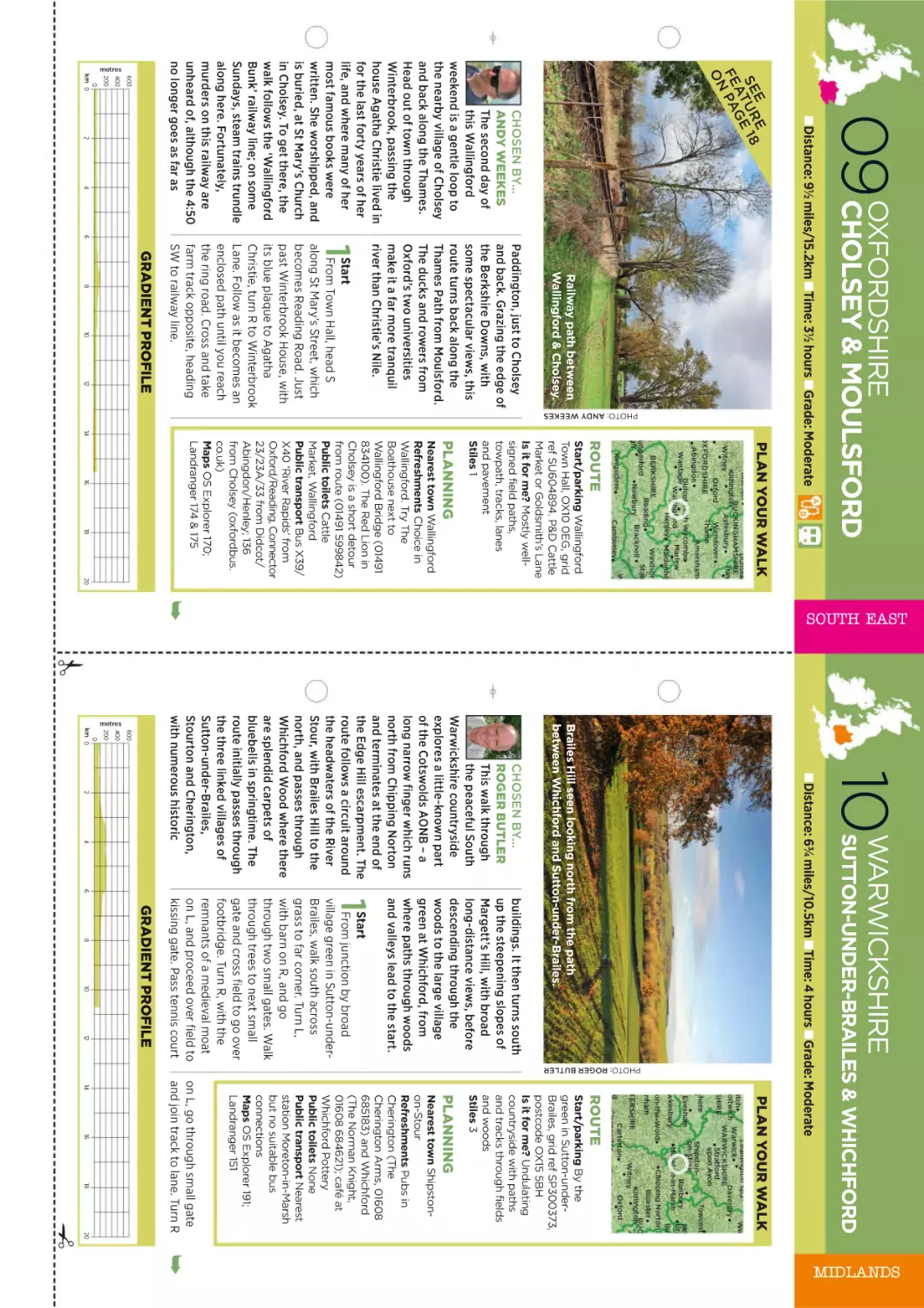
Christopher Somerville spent 40 years
running scared of geology. There was
only one way to fix the fear: a walk
into the bones of Britain.
INTERVIEW: NICK HALLISSEY
which animals we see on a walk. It can enrich our
understanding of any landscape. It’s just a question
of how we grasp the concepts involved without our
minds melting.”
It’s little surprise that Christopher’s solution would
involve a walk. He’s possibly Britain’s most prolific
author on walking, having written some 40 books
including The January Man, Never Eat Shredded
Wheat (The Geography We’ve Lost and How to
Find It) and Britain and Ireland’s Best Wild Places.
He’s also the walking correspondent of The Times.
But for this project, he reached back to his
former life as a teacher. Some 40 years ago,
Christopher came across an illustrated geological
map of Britain in a classroom textbook called
Philip’s Modern School Atlas. Beguiled by the
simple, colourful and beautiful way it rendered
three billion years of history in one image,
he ripped the page out (‘mea maxima
culpa’, he apologises) and took it
home. And he swiftly realised one
wonderful thing.
PHOTOS: JANE SOMERVILLE
G
EOLOGY, SIGHS CHRISTOPHER Somerville.
“It’s the thing most walkers would
probably like to know more about than
they do. We have a sense that it’s exciting and
important, and that knowing a bit about it might
enrich all those walks we go on.
“But then as soon as you dare to read more than
a few paragraphs about geology, you’re into
impenetrable stuff about Andesitic sheets of
laminated rhyolites and tuffaceous breccias.
And at that point, we switch off. I know because
that’s exactly how I was.”
So Christopher’s latest book, Walking the Bones
of Britain, is partly an exercise in exposure therapy:
a quest to face down that aversion, teach himself
geology in a way he could actually understand, and
then take his reader on a great big walk that would
bring it all to life.
“We’re right to have that sense that geology is
exciting and important, because it is,” he says.
“It underpins almost every aspect of our lives,
from where buildings are built to how we farm to
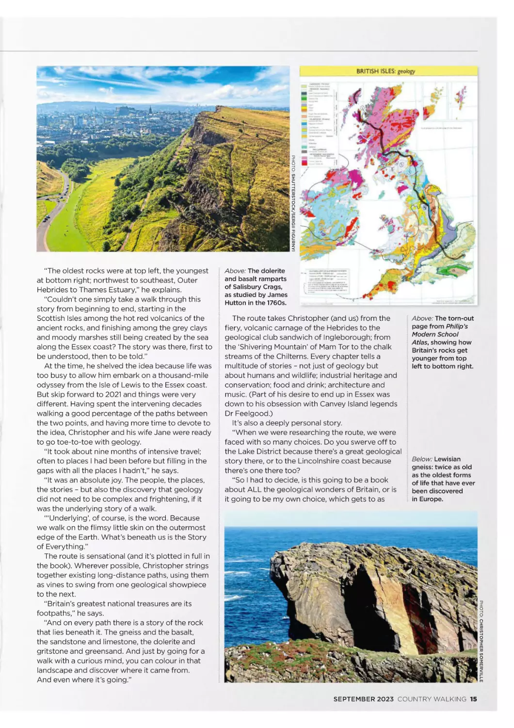
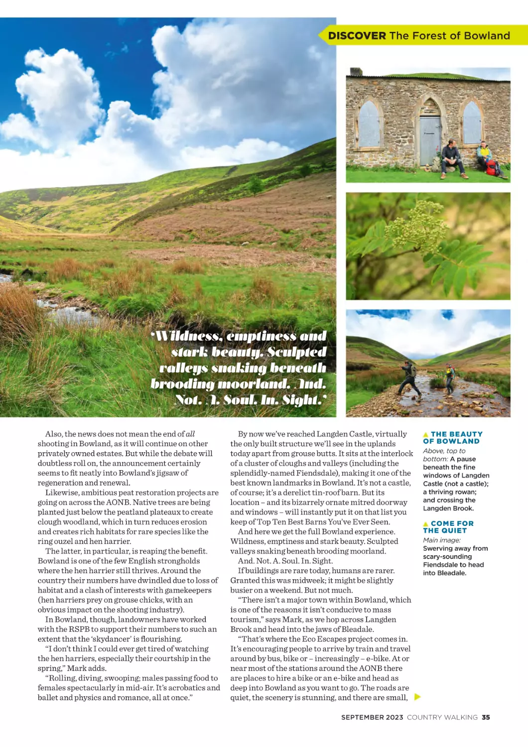
Top and above:
Christopher on
his travels into the
bones of Britain.
Below: The Butt of
Lewis, where his
journey begins,
among some of
the oldest rocks
in Britain.
PHOTO: SHUTTERSTOCK/
JOE GOUGH
PHOTO: SHUTTERSTOCK/SERGII FIGURNYI
Above: The dolerite
and basalt ramparts
of Salisbury Crags,
as studied by James
Hutton in the 1760s.
The route takes Christopher (and us) from the
fiery, volcanic carnage of the Hebrides to the
geological club sandwich of Ingleborough; from
the ‘Shivering Mountain’ of Mam Tor to the chalk
streams of the Chilterns. Every chapter tells a
multitude of stories – not just of geology but
about humans and wildlife; industrial heritage and
conservation; food and drink; architecture and
music. (Part of his desire to end up in Essex was
down to his obsession with Canvey Island legends
Dr Feelgood.)
It’s also a deeply personal story.
“When we were researching the route, we were
faced with so many choices. Do you swerve off to
the Lake District because there’s a great geological
story there, or to the Lincolnshire coast because
there’s one there too?
“So I had to decide, is this going to be a book
about ALL the geological wonders of Britain, or is
it going to be my own choice, which gets to as
Above: The torn-out
page from Philip’s
Modern School
Atlas, showing how
Britain’s rocks get
younger from top
left to bottom right.
Below: Lewisian
gneiss: twice as old
as the oldest forms
of life that have ever
been discovered
in Europe.
PHOTO: CHRISTOPHER SOMERVILLE
“The oldest rocks were at top left, the youngest
at bottom right; northwest to southeast, Outer
Hebrides to Thames Estuary,” he explains.
“Couldn’t one simply take a walk through this
story from beginning to end, starting in the
Scottish Isles among the hot red volcanics of the
ancient rocks, and finishing among the grey clays
and moody marshes still being created by the sea
along the Essex coast? The story was there, first to
be understood, then to be told.”
At the time, he shelved the idea because life was
too busy to allow him embark on a thousand-mile
odyssey from the Isle of Lewis to the Essex coast.
But skip forward to 2021 and things were very
different. Having spent the intervening decades
walking a good percentage of the paths between
the two points, and having more time to devote to
the idea, Christopher and his wife Jane were ready
to go toe-to-toe with geology.
“It took about nine months of intensive travel;
often to places I had been before but filling in the
gaps with all the places I hadn’t,” he says.
“It was an absolute joy. The people, the places,
the stories – but also the discovery that geology
did not need to be complex and frightening, if it
was the underlying story of a walk.
“‘Underlying’, of course, is the word. Because
we walk on the flimsy little skin on the outermost
edge of the Earth. What’s beneath us is the Story
of Everything.”
The route is sensational (and it’s plotted in full in
the book). Wherever possible, Christopher strings
together existing long-distance paths, using them
as vines to swing from one geological showpiece
to the next.
“Britain’s greatest national treasures are its
footpaths,” he says.
“And on every path there is a story of the rock
that lies beneath it. The gneiss and the basalt,
the sandstone and limestone, the dolerite and
gritstone and greensand. And just by going for a
walk with a curious mind, you can colour in that
landscape and discover where it came from.
And even where it’s going.”
SEPTEMBER 2023 COUNTRY WALKING 15
R
PHOTO: CHRISTOPHE
SOMERVILLE
PHOTO: SHUTTERSTOCK/STEVE MEESE
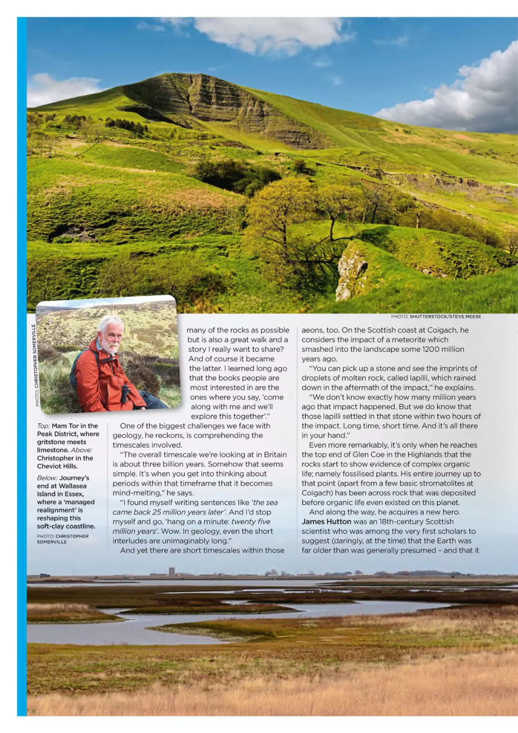
Top: Mam Tor in the
Peak District, where
gritstone meets
limestone. Above:
Christopher in the
Cheviot Hills.
Below: Journey’s
end at Wallasea
Island in Essex,
where a ‘managed
realignment’ is
reshaping this
soft-clay coastline.
PHOTO: CHRISTOPHER
SOMERVILLE
many of the rocks as possible
but is also a great walk and a
story I really want to share?
And of course it became
the latter. I learned long ago
that the books people are
most interested in are the
ones where you say, ‘come
along with me and we’ll
explore this together’.”
One of the biggest challenges we face with
geology, he reckons, is comprehending the
timescales involved.
“The overall timescale we’re looking at in Britain
is about three billion years. Somehow that seems
simple. It’s when you get into thinking about
periods within that timeframe that it becomes
mind-melting,” he says.
“I found myself writing sentences like ‘the sea
came back 25 million years later’. And I’d stop
myself and go, ‘hang on a minute: twenty five
million years’. Wow. In geology, even the short
interludes are unimaginably long.”
And yet there are short timescales within those
aeons, too. On the Scottish coast at Coigach, he
considers the impact of a meteorite which
smashed into the landscape some 1200 million
years ago.
“You can pick up a stone and see the imprints of
droplets of molten rock, called lapilli, which rained
down in the aftermath of the impact,” he explains.
“We don’t know exactly how many million years
ago that impact happened. But we do know that
those lapilli settled in that stone within two hours of
the impact. Long time, short time. And it’s all there
in your hand.”
Even more remarkably, it’s only when he reaches
the top end of Glen Coe in the Highlands that the
rocks start to show evidence of complex organic
life; namely fossilised plants. His entire journey up to
that point (apart from a few basic stromatolites at
Coigach) has been across rock that was deposited
before organic life even existed on this planet.
And along the way, he acquires a new hero.
James Hutton was an 18th-century Scottish
scientist who was among the very first scholars to
suggest (daringly, at the time) that the Earth was
far older than was generally presumed – and that it
THREE
QUESTIONS
WE ASK
EVERYONE
PHOTO: SHUTTERSTOCK/MARK GODDEN
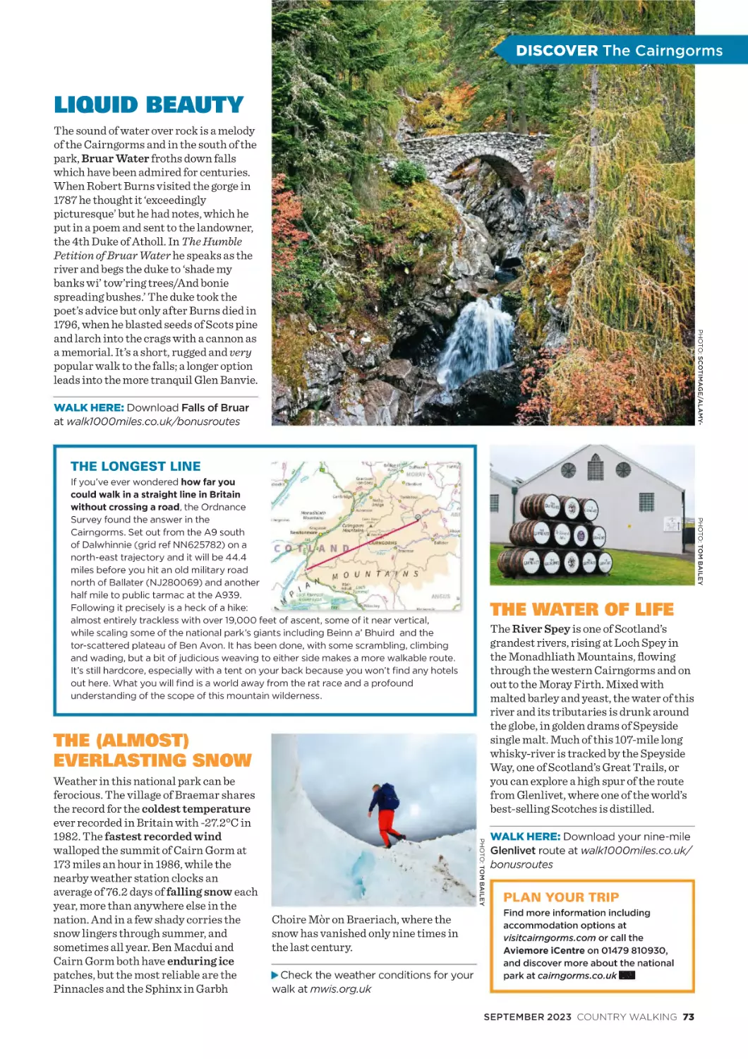
The Peak District is far from the sea these days, and yet
embedded in its stones are corals, shellfish and sea lilies.
“Yes, if you start reading something about the
geology of the Peak District on Google, it will
probably become impenetrable very quickly. But if
someone takes you on a great walk and says ‘come
on; I know how you feel but trust me – this is going
to be great’, hopefully it becomes a bit more of a
pleasure. And it unlocks knowledge that then adds
a whole new level of interest on every walk.
“James Hutton and a map in a school textbook
did it for me. I’m just trying
to pass it on.”
● Walking the Bones of
Britain is available from
24 August, published by
Penguin. For more about
Christopher’s work, visit
christophersomerville.co.uk
Follow him on Twitter
@somerville_c and Instagram
@somervillewalkman
What’s the best
walking snack?
Either an isotonic drink
and some raisins, or
a glass of beer and a
chocolate bar.
Take your pick.
We never ask ‘what’s
your favourite walk?’
But is there a place
where you can pause
and think, ‘yep, I’m
happy here’?
Upper Teesdale in the
spring, when the
curlews, snipe, lapwings
and redshanks are all
nesting so the place is
full of birdcall, and the
spring gentians and the
bird’s-eye primroses and
mountain pansies are
out. And the Tees is
in spate so it’s crashing
over High Force.
I’d love to be sitting on
top of Cronkley Fell
looking at all that and
sniffing it all in.
SEPTEMBER 2023 COUNTRY WALKING 17
PHOTO: WIKIMEDIA COMMONS
‘The
e book
ks people are
mo
ost interested in are
the
e ones where you say,
‘ccome with me… we’ll
ex
xplore this together’.’
PHOTO: CHRISTOPHER SOMERVILLE
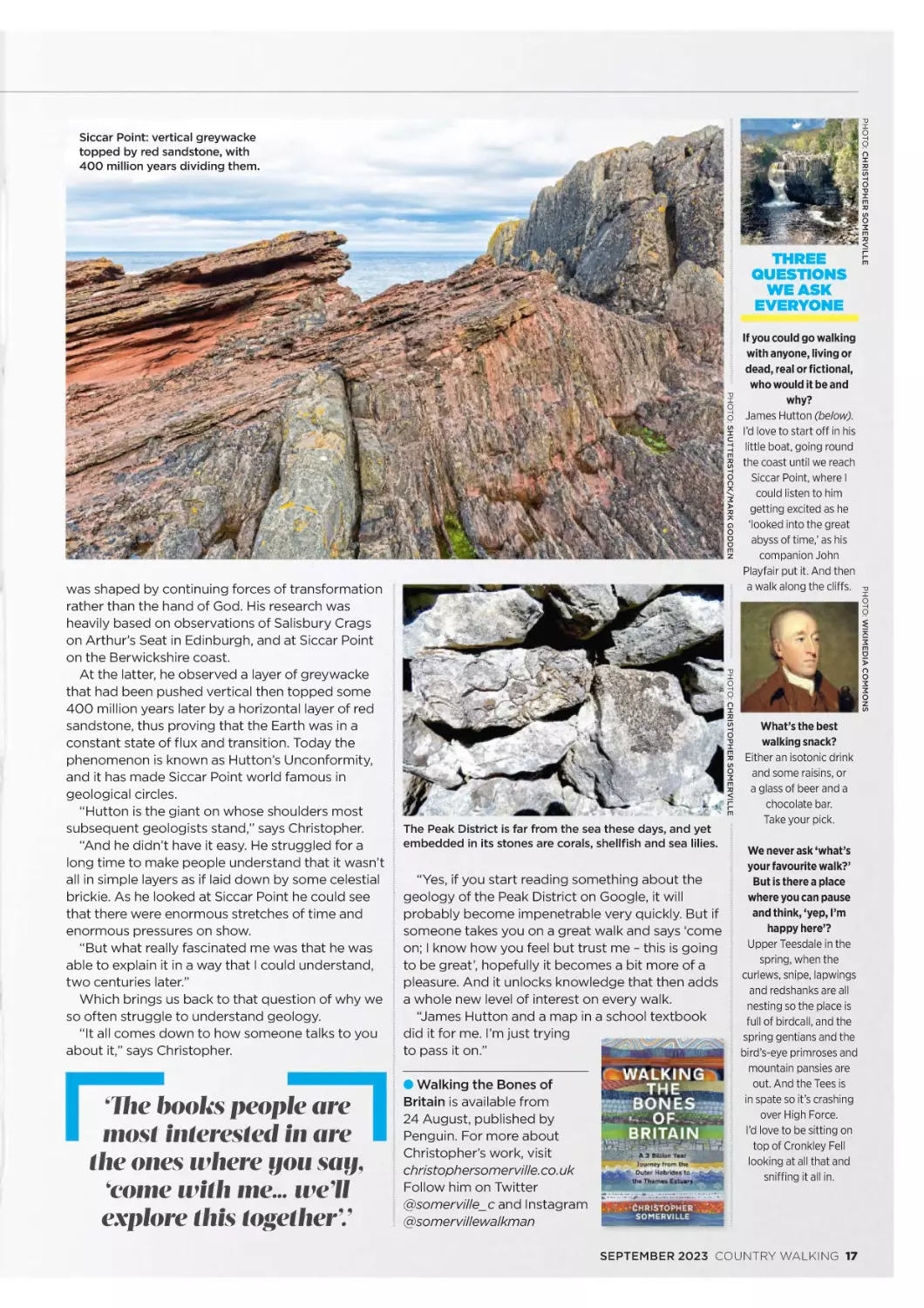
was shaped by continuing forces of transformation
rather than the hand of God. His research was
heavily based on observations of Salisbury Crags
on Arthur’s Seat in Edinburgh, and at Siccar Point
on the Berwickshire coast.
At the latter, he observed a layer of greywacke
that had been pushed vertical then topped some
400 million years later by a horizontal layer of red
sandstone, thus proving that the Earth was in a
constant state of flux and transition. Today the
phenomenon is known as Hutton’s Unconformity,
and it has made Siccar Point world famous in
geological circles.
“Hutton is the giant on whose shoulders most
subsequent geologists stand,” says Christopher.
“And he didn’t have it easy. He struggled for a
long time to make people understand that it wasn’t
all in simple layers as if laid down by some celestial
brickie. As he looked at Siccar Point he could see
that there were enormous stretches of time and
enormous pressures on show.
“But what really fascinated me was that he was
able to explain it in a way that I could understand,
two centuries later.”
Which brings us back to that question of why we
so often struggle to understand geology.
“It all comes down to how someone talks to you
about it,” says Christopher.
If you could go walking
with anyone, living or
dead, real or fictional,
who would it be and
why?
James Hutton (below).
I’d love to start off in his
little boat, going round
the coast until we reach
Siccar Point, where I
could listen to him
getting excited as he
‘looked into the great
abyss of time,’ as his
companion John
Playfair put it. And then
a walk along the cliffs.
PHOTO: CHRISTOPHER SOMERVILLE
Siccar Point: vertical greywacke
topped by red sandstone, with
400 million years dividing them.
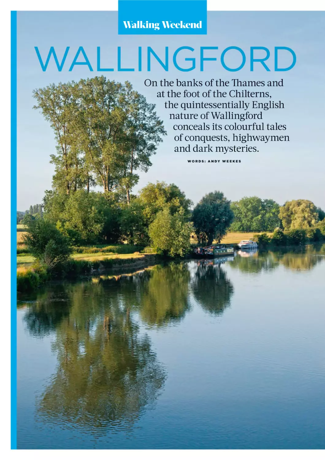
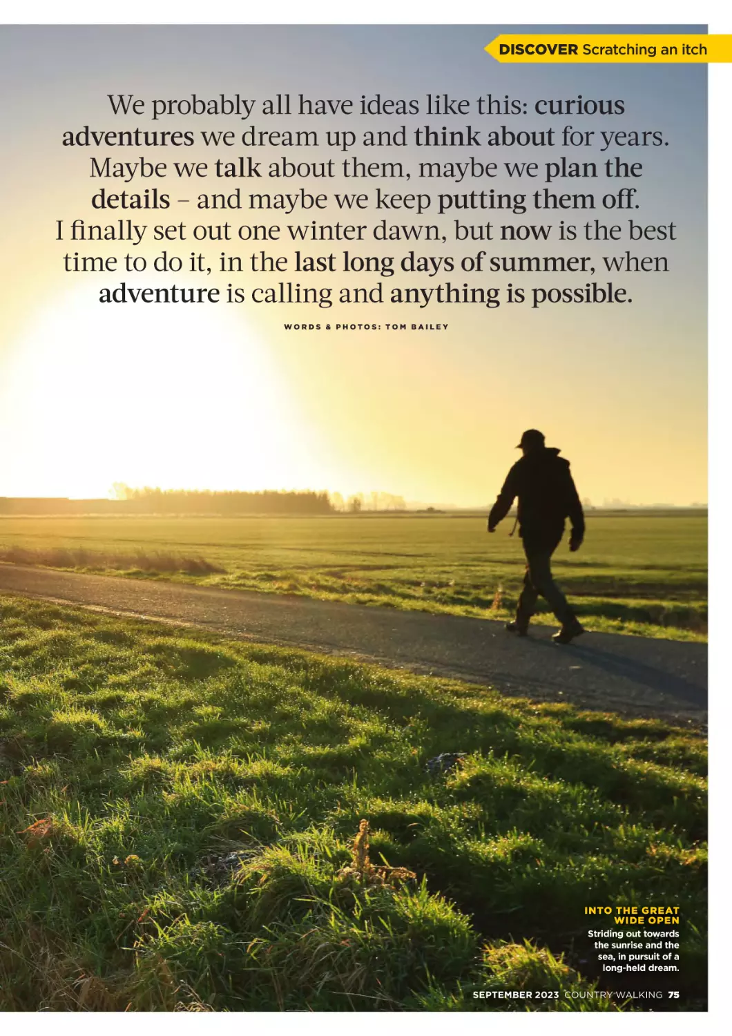
Walking Weekend
On the banks of the Th
Tha
ames and
at the foot of the Chilterns,
the quintessentially English
h
nature of Wallingford
conceals its colourful tales
of conquests, highwaymen
and dark mysteries.
WOR DS : AN DY WE E KE S
The View
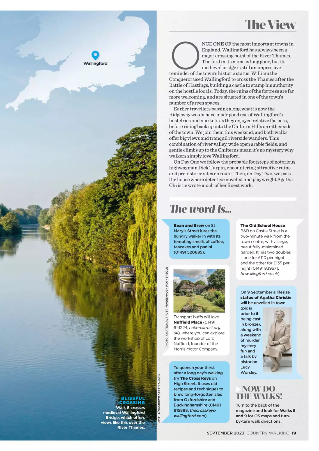
O
NCE ONE OF the most important towns in
England, Wallingford has always been a
major crossing point of the River Thames.
The ford in its name is long gone, but its
medieval bridge is still an impressive
reminder of the town’s historic status. William the
Conqueror used Wallingford to cross the Thames after the
Battle of Hastings, building a castle to stamp his authority
on the hostile locals. Today, the ruins of the fortress are far
more welcoming, and are situated in one of the town’s
number of green spaces.
Earlier travellers passing along what is now the
Ridgeway would have made good use of Wallingford’s
hostelries and markets as they enjoyed relative flatness,
before rising back up into the Chiltern Hills on either side
of the town. We join them this weekend, and both walks
offer big views and tranquil riverside wanders. This
combination of river valley, wide open arable fields, and
gentle climbs up to the Chilterns mean it’s no mystery why
walkers simply love Wallingford.
On Day One we follow the probable footsteps of notorious
highwayman Dick Turpin, encountering attractive ruins
and prehistoric sites en route. Then, on Day Two, we pass
the house where detective novelist and playwright Agatha
Christie wrote much of her finest work.
The word is…
PHOTO: ©NATIONAL TRUST IMAGES/HUGH MOTHERSOLE
Bean and Brew on St
Mary’s Street lures the
hungry walker in with its
tempting smells of coffee,
teacakes and panini
(01491 520685).
Walk 8 crosses
medieval Wallingford
Bridge, which offers
views like this over the
River Thames.
PHOTO: HARRY HARRISON/ALAMY
BLISSFUL
CROSSING
Transport buffs will love
Nuffield Place (01491
641224, nationaltrust.org.
uk), where you can explore
the workshop of Lord
Nuffield, founder of the
Morris Motor Company.
To quench your thirst
after a long day’s walking
try The Cross Keys on
High Street. It uses old
recipes and techniques to
brew long-forgotten ales
from Oxfordshire and
Buckinghamshire (01491
915888, thecrosskeyswallingford.com).
The Old School House
B&B on Castle Street is a
two-minute walk from the
town centre, with a large,
beautifully-maintained
garden. It has two doubles
– one for £110 per night
and the other for £135 per
night (01491 839571,
bbwallingford.co.uk).
On 9 September a lifesize
statue of Agatha Christie
will be unveiled in town
(pic is
prior to it
being cast
in bronze),
along with
a weekend
of murder
mystery
fun and
a talk by
historian
Lucy
Worsley.
NOW DO
THE WALKS!
Turn to the back of the
magazine and look for Walks 8
and 9 for OS maps and turnby-turn walk directions.
SEPTEMBER 2023 COUNTRY WALKING 19
BROUGHT TO YOU IN PARTNERSHIP WITH
June 2022
2.74 x 365 = walk1000miles.co.uk
Meet the
noughties!
2024
CALENDAR
It’s an exciting moment crossing any hundred-mile
threshold – and whether it’s a huge number or a more
modest one, there’s always so much more to celebrate
when you’re changing your life one step at a time!
900 MILES
200 MILES
‘A very
lot for me’
‘After badly breaking my leg on a
bike ride, I’ve been knocked off
course, but I’m coming up to 200
miles. Not a lot to some, but all
things considered, a very lot for
me. And I won’t give up walking!
I told my new consultant all about
#walk1000miles and we agree
hopefully I’ll be fixed enough next
year to complete the full 1000!’
Melanie Moss-Burton
‘Great for our
relationship’
‘I’m usually like a headless chicken,
but when I am out walking with
my boys it definitely helps with
our relationship, especially when
I’m on my own with the big one
(10) and we have time to talk
uninterrupted. Whatever miles you
are on, my advice is don’t push
it – do what you can when you can
(the dishes will be there when you
get back!).’ Zuzana Belas
600 MILES
‘Such happy memories'
‘Nothing has ever been made worse by going for a walk! The habit is
ingrained, and it’s brought such happy memories – like taking my kids to see
Cathedral Caves for the first time and watching them skip down the Langdales
after a pub lunch in the sunshine. I’m due to complete my 1000 miles while on the
Coast to Coast in September which I’m walking in aid of The Ambulance Staff
Charity – feels like a pretty cool place to hit that milestone!’ Hannah Beddoe
Made for walkers • Beautiful,
useful, fun • Space for your
miles • £7.99
walk1000miles.
co.uk/shop
1100 MILES
‘Not bad
six years
after a double
heart bypass’
‘1000 miles is the beginning not
the end. This is my third year since
retirement and my third year
doing the challenge. It really gives
me a focus and gets me up and
out of the house every single day,
come rain or shine. Nothing better
than a good walk followed by a
nice café. I’ve discovered so many
new places, many only a few miles
from home, and this year I am also
taking photos of listed buildings;
with more than 400,000 just in
England that should keep me on
the streets. In my first year doing
the challenge, 1000 miles seemed
near impossible, but getting out
every day the miles soon add up
and actually me and my lovely
wife walked 2021 miles together.
I also lost a few stone and felt
much fitter. Not bad six years after
a double heart bypass!’
Eddie Winder
Order your medal now: www.walk1000miles.co.uk/shop
900 MILES
‘You really can change
without realising it’
‘I’ve gained a clearer mind, which has helped me
climb out of depression. For anyone who thinks, like
I did, “I can’t do that,” you can! If a lazy fatty like me
can get to 900 miles in only 50% of the time, then
imagine what you can do. All it takes is a single step
and you’re away! My exercise was once to go to the
fridge for another beer, but now I’m so determined
to do at least five miles a day. You really can change
without realising it. I’ve put a pound for every mile
in a jar to fund the celebration!’ Gary Wright
700 MILES
‘Very proud of myself'
‘My most memorable walk this year was
15 miles overnight through London for charity, but
some of my favourite walks are when I get out at
lunchtime with a few others just down to the local
pond. It’s only just over a mile all round, but with
great company, it’s just what I need in my day.
Each step counts and even if you don’t reach the
destination, enjoy the journey. I’ll probably be at
work when I hit my 1000 miles so it’ll be a cup of tea
and a quiet inward cheer. I’m very proud of how well
I have done!’ Gerri Hickton
700 MILES
‘Not a competition –
a journey’
‘This is my fourth year – the challenge has made so much
difference to my life! I’ve gone on so many solo walking
adventures, as well as walks for charity, walks with friends
old and new, and I saw the sun rise on the summer solstice
on Marsden Moors. I’ve now started writing and getting
published, too, all because of walking! I recommend it to
everyone – it’s free, full of health benefits, there are so
many adventures out there to be had, and it’s not a
competition, it’s a journey!’ Julie James
900 MILES
‘Walking puts it
all into perspective’
‘Walking has kept me sane and fit and I’ve lost more
than three stone in the past year, which has made
hills something I WANT to do rather than them
being a necessary evil! Walking helps clear my
mind and put difficulties into a better perspective.
I’ll remember climbing Snowdon for a long time for
lots of reasons – fabulous weather, amazing views
and my favourite terrain! But the short walks are
just as important as longer walks. It all adds up.
Enjoy every step!’ Slinky Baloo
Be inspired by
your city walks
When challenger Katie Marsh was struggling for
motivation in her urban surroundings, she turned to the
lovely people on the #walk1000miles community for help…
Try to discover
something new each day
by walking different routes.
I’m currently discovering
Portsmouth’s old
graveyards!
Ginette White
One month I did a ‘letters
of the alphabet’ game. So
day one, letter A, day two,
letter B, and so on. That
worked really well when
walking with the kids.
Clare Cooper
Try Treasure Trails. We’re
from near Nottingham and
there must be at least 10 not
far away. They do cost
money, but are brilliant fun.
Deborah Williams
Look up! I find city
streets fascinating when you
stop and look at the skyline
or rooftops. It’s amazing
what you find!
Lynn Grant
Walk different routes to
find as many seasonal
features as you can
(snowdrops, daffodils,
magnolias, roses, apples on
trees, autumn leaves, etc).
Then work out the best
route to see as many as
possible in one walk. It
makes the walks dynamic,
as the timing of the seasons
changes from year to year.
An overnight storm or frost
can change everything.
This has kept me happy as
a suburban pavement
pounder for years.
Lucy Cook
Urban sketching is worth
a go. You don’t have to be
good, it just encourages
you to look closely and
see things.
Zena Hagger
Look for strange
windows, funny shaped
roofs, animals, birds, etc
– pick something different
every time you go
for a walk.
Susan Miller
A colleague of mine
printed a copy of our
city centre street map
and every lunch hour he
walked a different route
and highlighted each
one until he’d coloured
the whole map.
Lynne Bishop
I sometimes take a copy
of an 1885 map and hunt out
the different things. Living
in the north, I find lots
of industrial relics.
Peter Jeynes
Recently, I amused
myself by making my
own rainbow – taking
photos of anything
colourful. It’s surprising how
much colour there is that
you just don’t notice!
Bryony Brown
Take photos of gardens,
hedges and views, then
repeat it every couple
of weeks to see what
differences there are.
Mary Roberts
Look into the history
of places and see what
gruesome goings-on
have taken place.
Heather West
I walk down the ‘posh’
roads near me and
admire the houses!
Hilary Richardson
How about geocaching?
That’ll add a bit of fun and
take you to places you
hadn’t been before.
Jane Siddorn
SEPTEMBER 2023 COUNTRY WALKING 21
#WALK1000MILES UPDATE
THANKS FOR THE INSPIRATION!
Walk yourself
to sleep
Long-term, poor sleep can kill you. But walking can not only aid sleep,
it can also prevent premature death even if you continue to sleep badly.
I
F YOU DON’T exercise, it’ll take two
or three decades to catch up with
you. A poor diet might take longer.
But if you don’t sleep well, you’ll
know about it straight away.
You’ll be cranky, you’ll feel tired, you’ll
be less alert, less efficient and less able
to solve problems. And, as annoying as
all those might be, the long-term effects
of chronic sleep deprivation are far
more serious.
Your chances of getting heart disease,
diabetes, stroke and depression
increase markedly if you don’t sleep well
over a long period of time, as does your
chance of premature death. “People
who are short sleepers – below six hours
– tend to be more obese than those who
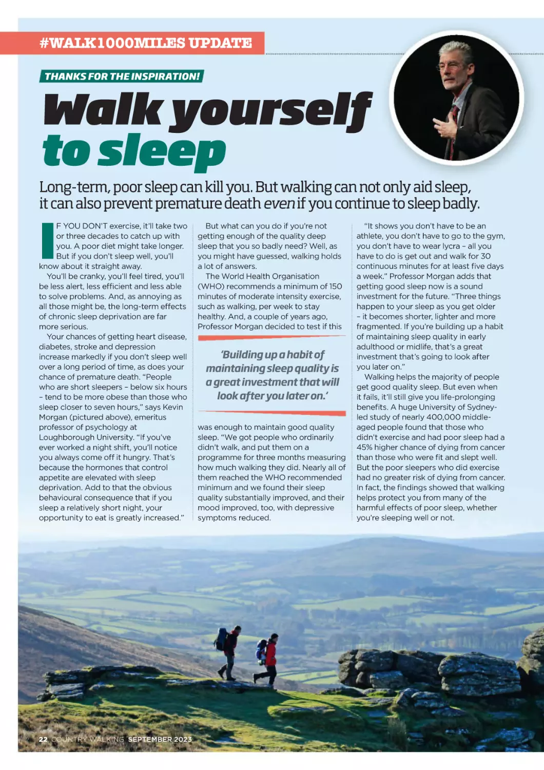
sleep closer to seven hours,” says Kevin
Morgan (pictured above), emeritus
professor of psychology at
Loughborough University. “If you’ve
ever worked a night shift, you’ll notice
you always come off it hungry. That’s
because the hormones that control
appetite are elevated with sleep
deprivation. Add to that the obvious
behavioural consequence that if you
sleep a relatively short night, your
opportunity to eat is greatly increased.”
22 COUNTRY WALKING SEPTEMBER 2023
But what can you do if you’re not
getting enough of the quality deep
sleep that you so badly need? Well, as
you might have guessed, walking holds
a lot of answers.
The World Health Organisation
(WHO) recommends a minimum of 150
minutes of moderate intensity exercise,
such as walking, per week to stay
healthy. And, a couple of years ago,
Professor Morgan decided to test if this
‘Building up a habit of
maintaining sleep quality is
a great investment that will
look after you later on.‘
was enough to maintain good quality
sleep. “We got people who ordinarily
didn’t walk, and put them on a
programme for three months measuring
how much walking they did. Nearly all of
them reached the WHO recommended
minimum and we found their sleep
quality substantially improved, and their
mood improved, too, with depressive
symptoms reduced.
“It shows you don’t have to be an
athlete, you don’t have to go to the gym,
you don’t have to wear lycra – all you
have to do is get out and walk for 30
continuous minutes for at least five days
a week.” Professor Morgan adds that
getting good sleep now is a sound
investment for the future. “Three things
happen to your sleep as you get older
– it becomes shorter, lighter and more
fragmented. If you’re building up a habit
of maintaining sleep quality in early
adulthood or midlife, that’s a great
investment that’s going to look after
you later on.”
Walking helps the majority of people
get good quality sleep. But even when
it fails, it’ll still give you life-prolonging
benefits. A huge University of Sydneyled study of nearly 400,000 middleaged people found that those who
didn’t exercise and had poor sleep had a
45% higher chance of dying from cancer
than those who were fit and slept well.
But the poor sleepers who did exercise
had no greater risk of dying from cancer.
In fact, the findings showed that walking
helps protect you from many of the
harmful effects of poor sleep, whether
you’re sleeping well or not.
Get your 2024 calendar: www.walk1000miles.co.uk/shop
Walk more,
sleep better
‘I can hardly believe
how much my sleep
has improved!’
‘I’ve had years of terrible sleeping patterns for
various reasons. But now that I’m walking more
I’ve noticed such an improvement in the hours
and quality of my sleep. I can hardly believe it! It
can’t be a coincidence! I’ve always done fitness
classes – mostly yoga and pilates – but since
starting this challenge I’m definitely sleeping
loads better. It’s so wonderful! I shall definitely
keep going. Everything is totally different when
you sleep properly!’ Jennifer Parker
‘I have the best sleep
ever after a walk’
‘I used to have problems going to
sleep and getting a good night’s rest, as my
mind would go into overdrive. I tried many
things (including relaxation techniques) but
nothing worked. However, when I found
walking, I no longer had that problem. I now
sleep nearly nine hours every night and the only
time I don’t is when I haven’t walked. There’s no
better feeling than getting into bed after a day’s
walking feeling a little bit achy, but also
physically tired. I then wake in the morning
totally refreshed after a fabulous night’s sleep
ready to walk to work.’ Karen Ley
‘I feel calmer
when I walk’
‘I’ve always had a lot of difficulty
getting to sleep at night. When I walk to and
from work (three miles each way) I feel less
stressed than if I get the bus. It gives me
thinking and processing time and I’m generally
calmer and fall asleep quicker. On non-work
days, I get very restless if I don’t go out for a
walk, and definitely take longer to get to sleep.
I still get the occasional bad night, but far fewer
than when I walked less.’ Dorothy Edwards
‘Walking helps me
get a better sleep‘
‘I became a real insomniac during
chemotherapy. Then, years of medication
ensured I never got back into a good sleep
routine. But walking (and swimming when I can)
definitely helps me to get a better sleep. On the
nights when I still struggle I often spend time
going over some of my favourite walks in my
head… much more fun than counting sheep!’
Jan Snape
SCIENCE
Surprising
benefits of
walking…
backwards
We’re all aware of the myriad ways walking boosts
health and happiness – but did you know walking
backwards tunes up your gait, balance, joints and
more? Recent scientific studies found short periods of
backwards walking effectively ‘force refreshes’ our
visual, vestibular and proprioceptive systems (the
suite of sensors which enable us to walk), leading to
improvements in forward stability, gait and balance.
Backwards walkers also take smaller, more frequent
steps, boosting the muscle endurance of the lower legs,
reducing the burden on joints and altering the range of
motion, which can relieve conditions such as plantar
fasciitis and knee pain. Spells of walking backwards also
force us to use more of the muscles supporting our
lumbar spine, warding off lower back pain. It’s slimming
too, consuming 40% more calories than walking at the
same speed forwards. But, perhaps most significantly
as we age, walking backwards for 5-10 minutes a few
times a week reduces the risk we’ll fall at any time – and,
according to the World Health Organisation, that’s the
number one cause of injury and death in over-65s.
THE 2024
CALENDAR
Made for walkers •
Beautiful, useful, fun •
Record your miles • And
are you in it? • £7.99
walk1000miles.
co.uk/shop
Pin up inspiration
The key to happiness is walking, and the way to do more
of that is to be inspired every day, and have somewhere to
book your plans in early, before life auto-fills your months.
If you’re a walker, this is your calendar.
The most inspiring images, complete with OS maps so you
can walk to the very spot they were captured; a life-enhancing
to-do list of ideas, space to record your miles, useful info like
sunrises, full moons, and even days to spot meteor showers;
and don’t miss Naked Hiking Day, National Cake Eating Day
and Hug a Tree day? Oh, and hundreds of you are in it!
SEPTEMBER 2023 COUNTRY WALKING 23
#WALK1000MILES UPDATE
SEEN
YOU’VE
WON?
Email walk1000miles@
countrywalking.co.uk with
your address and a pic of
you holding this edition
to claim your
precious!
#MINICHALLENGES
Major spoils
for mini challengers!
Twenty winners of each month’s mini-challenges earn a money-can’t-buy
Golden Badge! Come on, join in!
#minichallenge31
#minichallenge32
Find a heart in
a strange place
Send us the
worst postcard
you can find
Lizzie Wright
Helen Lewis
Julie Johnson, with her
take on finding a heart on
your walk. ‘The sunset as the
Anette Loveland heart of the Walking Man’.
The Training Centre
of the Cement &
Concrete Association
– a must-visit from
Melanie Moss-Burton.
Unparalleled crumminess from
Gillian Gee!
Who could
resist a stay
in Costa
Blancashire?!
Not Hannah
Beddoe!
#minichallenge33
Have an in-tents
experience
Clare Pickford
had a weekend in
the Welsh mountains
that truly soothed
her soul. ‘My tent
looked out over a
little mountain, the
walking was glorious
and the views
stupendous.’
Unmistakably Brighton!
Thanks Gina Crees!
#minichallenge34
Kiss a cairn
Salyen Latter.
One tent, two
people, cake,
tea and boots.
Lochan na
h’Earba about
5k walk in from
Loch Laggan.
Elaine Brown
‘some of my most
amazing, in-tents
solo camping has
been in Northern
Norway, the land of
the midnight sun
and friluftsliv; the
fresh air… and it's
all free’.
Andy Millen has
had some intents
moments in his
Macpac Zenith
Ultralight oneperson 3/4 season
tent, this year.
24 COUNTRY WALKING SEPTEMBER 2023
Susie Carling on a walk up to The
Matt Bowker in Swaledale
valley.
Twelve Apostle stones.
Slinky Baloo at Mill Hill
cairn, Peak District.
Ian Jones on Sgùrr nan Clach Geala.
Medals and more: www.walk1000miles.co.uk/shop
#minichallenge35
Do more and
win treasure!
Make friends with
meadowsweet
Linda MilesCartright has found
loads growing in the
hedgerows in South
Shropshire. ‘It has the
most incredible
perfume and also
makes great wine too.’
Emma Harding
met up with Mr
Meadowsweet, shook
hands, and they went
on an evening walk
together.
Chris Claridge
getting amongst the
meadowsweet around
Burbage Common.
Anna Stares had
never picked or used
meadowsweet
before this
challenge. She says
‘I think it’s probably
one of those flavours
that splits people,
you’ll either love it
or hate it. I love it.
I’ve made a
meadowsweet
ice cream with a
meadowsweet syrup
and infused it in a
batter before making
clafoutis.’
SOME THINGS ARE
WORTH CELEBRATING!
Like walking 1000 miles and your membership of
biggest & best community in the outdoors!
walk1000miles.co.uk/shop
NEW NECK TUBE
£8.9
Spice up your miles with one of our quests, post the
result in the Facebook group and our favourite 20 will
win a Golden Badge! You have until 14 September for
this crop. Got a suggestion for a challenge? Email us!
walk1000miles@countrywalking.co.uk
41
WALK A MILE
BACKWARDS
It’s time you sampled the surprising
benefits of backwards walking (see
p23). Set against all those what’s 1
out of 1000 miles under conditions
of extreme self-consciousness?
42
PACK A PINEAPPLE
Full of a wonder-enzyme
called bromelain, which relieves
arthritis, sinusitis and inflammation,
promotes healing and boosts
immunity, this is a riot to pull out
of your pack at lunch!
43
9
The brand new edition of our
versatile, stretchy, seamless
microfibre neck tube keeps you warm
in the cold and cool in the warm – and
features an exclusive design complete
with walker-friendly details down to
our old friend the badger, all doodled
by us. And most importantly it’s a
total pleasure to wear.
44
BADGER STICKER SETT
Harvested fields make hares more
visible and it’s a treat to these
shapely long-eared athletes with
the blade-like hind legs. Quick!
Capture one on camera.
Take the challenge mascot,
add the spirit of #walk
£5.99
1000miles and what do
you get? Our fantastic new
badger stickers! These are
tough, durable, waterproof
vinyl stickers perfect for
water bottles, laptops,
cars, campervans,
fridges, gear cupboards
or wherever you need
reminding of the #walk1000miles vibe.
#minichallenge42
STAND ON A
STRAW BALE
Not enough clambering in adult life.
Put that right by surmounting a
stout, stable straw bale and enjoy
that Titanic-aping ‘king of the
walking world’ feeling.
#minichallenge43
FIND A FEATHER
A feather is a hard-working,
consumable marvel delivering
thrust and control to its owner,
over thousands of wingbeats
before being shed. Go out. Find
one. And then show us!
45
#minichallenge41
#minichallenge44
CAPTURE A HARE
(ON CAMERA)
#minichallenge45
How to enter
Upload photo evidence including the relevant hashtag
in the #walk1000miles Facebook group or on
Instagram by 14 September! New challenges next
issue and every issue. Got an idea for a challenge?
Email us walk1000miles@countrywalking.co.uk
BROUGHT TO YOU IN PARTNERSHIP WITH
SEPTEMBER 2023 COUNTRY WALKING 25
WRITE
TO US AT:
Country Walking,
Media House,
Lynch Wood,
Peterborough
PE2 6EA
EMAIL: editorial@countrywalking.co.uk ● FACEBOOK: facebook.com/countrywalking ● TWITTER: twitter.com/countrywalking
In-spiring
stuff
I love the magazine but due
to arthritis in my knees
I can’t venture too far. Local
to me is the Chesterfield
canal, which is being
rejuvenated between
Chesterfield and Worksop.
Chesterfield to Staveley has
been open for some time
now and the towpath being
nice and flat is perfect for
a nice steady walk of five or
so miles. Always enjoy the
sight of the Crooked Spire
Chesterfield. Thanks for a
lively magazine which I wait
for every month.
Phil Hodgkiss, by email
LETTER OF THE MONTH
This place is my place
being a bridleway, and only walkers and
dogs on leads are allowed.
I have ‘my own’ stone by the
boundary wall, where I sit for lunch
and invariably never see another soul
– maybe a kestrel hovering above and
a skylark singing its heart out for
company. Wharncliffe Crags can be
found bordering the other side of the
Chase, which also offers stunning views
of the reservoirs of Ewden Valley and
surrounding area. The Trans Pennine
Trail and a nature reserve area are
within walking distance.
This historic site became my go-to
place – not only during lockdown, but
also since the death of my husband last
November. A place to be myself and
allow the healing properties of nature to
work their magic.
Judith Parker Dixon, Sheffield
A BERGHAUS WATERPROOF JACKET FOR JUDITH!
The letter of the month wins a Berghaus waterproof jacket worth
(£225). The Cornice (men’s) and Glissade (women’s) jackets have been
firm favourites with walkers for decades, are superb quality and always
score highly in Country Walking gear tests. www.berghaus.com
26 COUNTRY WALKING SEPTEMBER 2023
Honest advice
We wholeheartedly agree
with Mary Hardy about
Chrome & Parkhouse Hills
(Your View, August) and
feel we should also mention
the fabulous honesty ‘café’
at Hollinsclough. It was a
wet and cold day so the hot
drinks and snacks were
extremely welcoming.
There were all kinds of
wares, payable by cash or
contactless card (sign of the
times). A little gem in the
middle of a fabulous walk.
Lynn Tattersall, Worksop
PHOTO: ZOE/SHE WALKS ENGLAND
I was delighted to read about Jenny
Walters’ secret walk (Footnotes, July
2023) and inspired to write about my
own special place. At 80 years old and
having loved walking since my teens,
it was so validating to know my
feelings of ‘this is my place’ are shared.
I explored locally and discovered my
walk during lockdown – a place I could
walk to on a round trip from home. It
took a few trial walks before I finally
reached Wharncliffe Chase. A thousand
feet above sea level, a slightly undulating,
top-of-the-world sort of place. An
isolated expanse punctuated by a
couple of wooded areas and a few
sheep. An ancient hunting park dating
back to the 16th/17th centuries, the
Chase is still surrounded by its boundary
wall with limited access points. A sign
says there is no record of this ever
The View
Sea to summit
Thanks for another inspirational edition. My wife and I
have done a few walks from sea to summit (Blà Bheinn,
for one, many years ago). I’d always wanted to climb
An Teallach (Western Highlands) and a few years ago
a holiday in the Ullapool area allowed us to do just that.
We parked at the edge of Little Loch Broom near
Ardressie and ascended to the An Teallach trig point at
Bidein a’ Ghlas Thuill. Unfortunately the weather was
not at its clearest to say the least, and though I’d really
wanted to reach ‘Lord Berkeley’s Seat’ the probable
further ascent would have been treacherous.
Nonetheless it was an invigorating climb of more than
1000m! The pictures are taken at the summit and on
our descent showing the loch in the background.
Goff Payne, by email
Doctor’s orders
In the last bank holiday weekend, blessed by the most
perfect hiking weather I have ever seen (a bright sun without
the glaring blaze, a light breeze not a blustery wind, excellent
visibility and turquoise blue skies), I joined five colleagues
and another friend in completing the Yorkshire Three Peaks.
We didn’t make the 12 hours time, but we completed the
circuit with spirits and legs intact. Most importantly, we made
wonderful memories.
Our ages ranged from twenties to fifties. We’ve bonded
with our love of the outdoors, but most of us are mental
health professionals – psychiatrist, psychiatric nurse,
psychotherapist. We love walking ourselves and encourage it
among our patients. We passionately believe in the outdoors
and walking being a great way to improve mental health,
connect with nature, take a step back from busy lives and
reflect. Some of us run a monthly hiking group for patients
with first episode of psychosis.
The Yorkshire Three Peaks certainly gives a lot of scope
for this. Being on the trail for around 12 hours and more,
surrounded by mountains and summer flowers, is a recipe for
finding oneself deep within. This is the second time I’ve done
the trail. Every time, I promise myself never again. And then
as I reminisce I think.... maybe next year, once again!
Nandini Chakraborty, Leicester
Going all the way
Grit and glory
Very interesting Sea to Summit item in the last issue.
Certainly makes your ascent seem more worthy if the
figure matches the advertised height of the hill. You
included some fairly high summits in the feature, but the
biggest of all, Ben Nevis, is practically a sea to summit
walk. Most people set out from Glen Nevis or the Ben
Nevis Inn, from where you still have to ascend most of
the 1345m height. The Scottish islands also provide
great opportunities for sea to summit walking. The only
Munro on an island other than Skye (Ben More on Mull)
is usually climbed from by the coast at Dhiseig. So
Scotland’s highlands and islands really do offer great
opportunities for some serious sea to summit walks.
Martin Saxon, Stockport
Many thanks for the story in July’s issue about the Gritstone
Trail. Living in the Peak District for more than 35 years I’ve
walked the Trail on a number of occasions, always taking
three days, and although the last couple of miles are a little
dull compared with what has gone before it is a very
enjoyable walk. You can get a bus between Langley
(home of the Leather Smithy pub) and Macclesfield with
a little planning and it’s really only a short detour from the
route to the train station at Congleton, its two accompanying
pubs meaning accommodation options are more plentiful.
I always look forward to the magazine dropping through
my letterbox. Keep up the good work!
Peter James, by email
SEPTEMBER 2023 COUNTRY WALKING 27
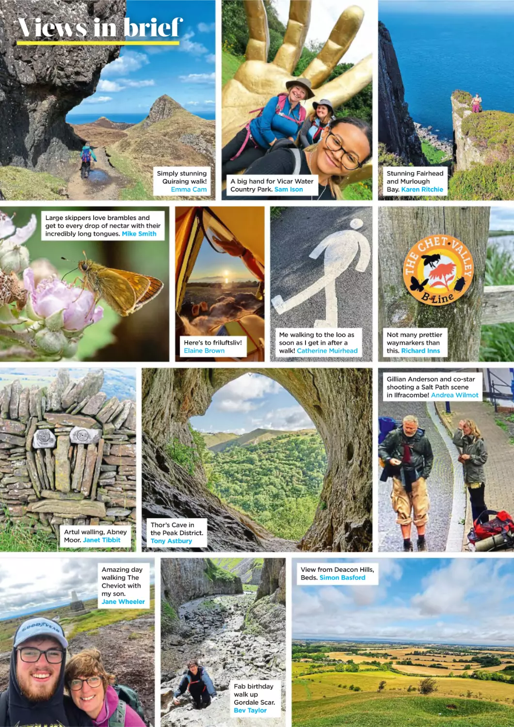
Views in brief
Simply stunning
Quiraing walk!
Emma Cam
A big hand for Vicar Water
Country Park. Sam Ison
Stunning Fairhead
and Murlough
Bay. Karen Ritchie
Large skippers love brambles and
get to every drop of nectar with their
incredibly long tongues. Mike Smith
Here’s to friluftsliv!
Elaine Brown
Me walking to the loo as
soon as I get in after a
walk! Catherine Muirhead
Not many prettier
waymarkers than
this. Richard Inns
Gillian Anderson and co-star
shooting a Salt Path scene
in Ilfracombe! Andrea Wilmot
Artul walling, Abney
Moor. Janet Tibbit
Thor’s Cave in
the Peak District.
Tony Astbury
View from Deacon Hills,
Beds. Simon Basford
Amazing day
walking The
Cheviot with
my son.
Jane Wheeler
Fab birthday
walk up
Gordale Scar.
Bev Taylor
The View
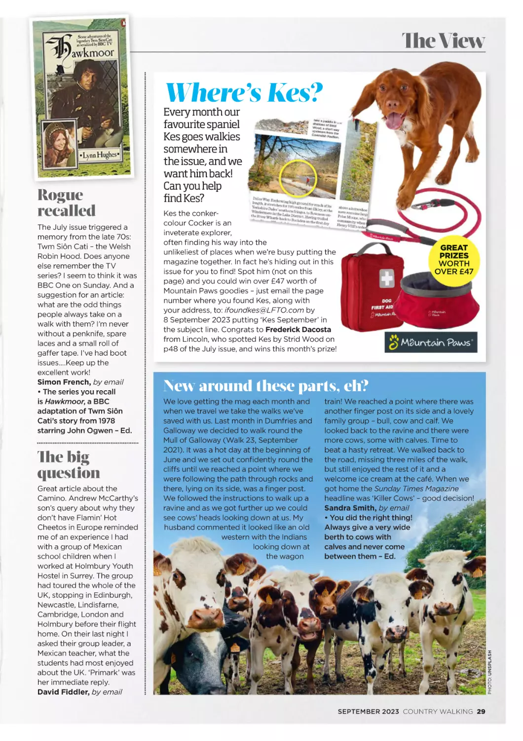
Where’s Kes?
The July issue triggered a
memory from the late 70s:
Twm Siôn Cati – the Welsh
Robin Hood. Does anyone
else remember the TV
series? I seem to think it was
BBC One on Sunday. And a
suggestion for an article:
what are the odd things
people always take on a
walk with them? I’m never
without a penknife, spare
laces and a small roll of
gaffer tape. I’ve had boot
issues....Keep up the
excellent work!
Simon French, by email
• The series you recall
is Hawkmoor, a BBC
adaptation of Twm Siôn
Cati’s story from 1978
starring John Ogwen – Ed.
The big
question
Great article about the
Camino. Andrew McCarthy’s
son’s query about why they
don’t have Flamin’ Hot
Cheetos in Europe reminded
me of an experience I had
with a group of Mexican
school children when I
worked at Holmbury Youth
Hostel in Surrey. The group
had toured the whole of the
UK, stopping in Edinburgh,
Newcastle, Lindisfarne,
Cambridge, London and
Holmbury before their flight
home. On their last night I
asked their group leader, a
Mexican teacher, what the
students had most enjoyed
about the UK. ‘Primark’ was
her immediate reply.
David Fiddler, by email
Kes the conkercolour Cocker is an
inveterate explorer,
often finding his way into the
unlikeliest of places when we’re busy putting the
magazine together. In fact he’s hiding out in this
issue for you to find! Spot him (not on this
page) and you could win over £47 worth of
Mountain Paws goodies – just email the page
number where you found Kes, along with
your address, to: ifoundkes@LFTO.com by
8 September 2023 putting ‘Kes September’ in
the subject line. Congrats to Frederick Dacosta
from Lincoln, who spotted Kes by Strid Wood on
p48 of the July issue, and wins this month’s prize!
GREAT
PRIZES
WORTH
OVER £47
New around these parts, eh?
We love getting the mag each month and
when we travel we take the walks we’ve
saved with us. Last month in Dumfries and
Galloway we decided to walk round the
Mull of Galloway (Walk 23, September
2021). It was a hot day at the beginning of
June and we set out confidently round the
cliffs until we reached a point where we
were following the path through rocks and
there, lying on its side, was a finger post.
We followed the instructions to walk up a
ravine and as we got further up we could
see cows’ heads looking down at us. My
husband commented it looked like an old
western with the Indians
looking down at
the wagon
train! We reached a point where there was
another finger post on its side and a lovely
family group – bull, cow and calf. We
looked back to the ravine and there were
more cows, some with calves. Time to
beat a hasty retreat. We walked back to
the road, missing three miles of the walk,
but still enjoyed the rest of it and a
welcome ice cream at the café. When we
got home the Sunday Times Magazine
headline was ‘Killer Cows’ – good decision!
Sandra Smith, by email
• You did the right thing!
Always give a very wide
berth to cows with
calves and never come
between them – Ed.
PHOTO: UNSPLASH
Rogue
recalled
Every month our
favourite spaniel
Kes goes walkies
somewhere in
the issue, and we
want him back!
Can you help
find Kes?
SEPTEMBER 2023 COUNTRY WALKING 29
The View
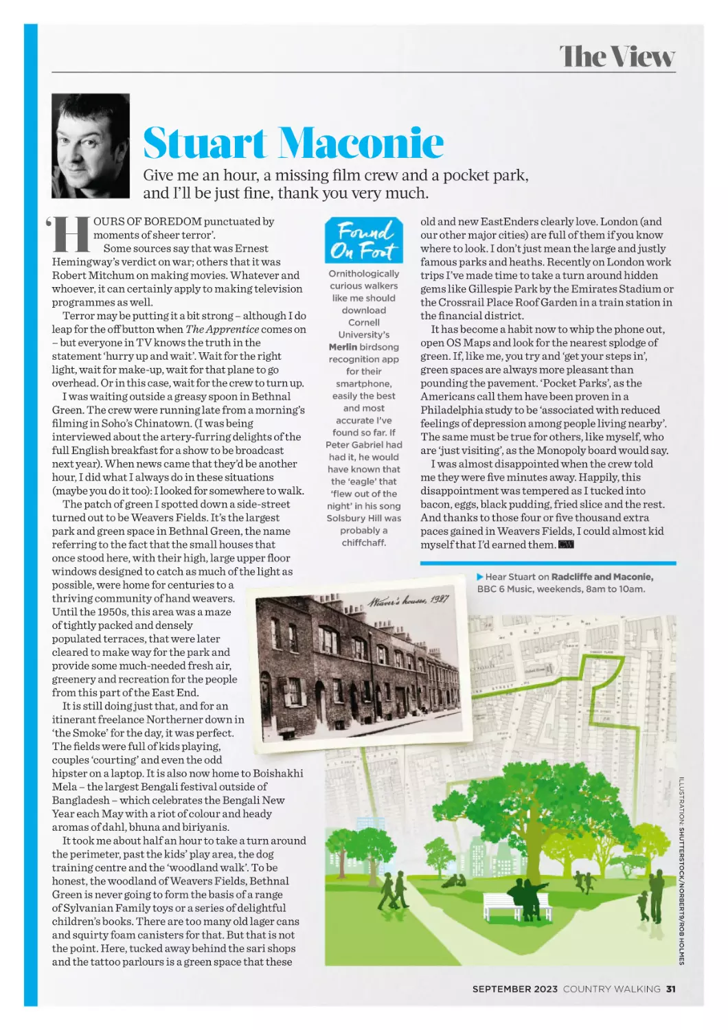
Stuart Maconie
Give me an hour, a missing film crew and a pocket park,
and I’ll be just fine, thank you very much.
H
‘
Ornithologically
curious walkers
like me should
download
Cornell
University’s
Merlin birdsong
recognition app
for their
smartphone,
easily the best
and most
accurate I’ve
found so far. If
Peter Gabriel had
had it, he would
have known that
the ‘eagle’ that
‘flew out of the
night’ in his song
Solsbury Hill was
probably a
chiffchaff.
old and new EastEnders clearly love. London (and
our other major cities) are full of them if you know
where to look. I don’t just mean the large and justly
famous parks and heaths. Recently on London work
trips I’ve made time to take a turn around hidden
gems like Gillespie Park by the Emirates Stadium or
the Crossrail Place Roof Garden in a train station in
the financial district.
It has become a habit now to whip the phone out,
open OS Maps and look for the nearest splodge of
green. If, like me, you try and ‘get your steps in’,
green spaces are always more pleasant than
pounding the pavement. ‘Pocket Parks’, as the
Americans call them have been proven in a
Philadelphia study to be ‘associated with reduced
feelings of depression among people living nearby’.
The same must be true for others, like myself, who
are ‘just visiting’, as the Monopoly board would say.
I was almost disappointed when the crew told
me they were five minutes away. Happily, this
disappointment was tempered as I tucked into
bacon, eggs, black pudding, fried slice and the rest.
And thanks to those four or five thousand extra
paces gained in Weavers Fields, I could almost kid
myself that I’d earned them.
Hear Stuart on Radcliffe and Maconie,
BBC 6 Music, weekends, 8am to 10am.
ILLUSTRATION: SHUTTERSTOCK/NORBERT9/ROB HOLMES
OURS OF BOREDOM punctuated by
moments of sheer terror’.
Some sources say that was Ernest
Hemingway’s verdict on war; others that it was
Robert Mitchum on making movies. Whatever and
whoever, it can certainly apply to making television
programmes as well.
Terror may be putting it a bit strong – although I do
leap for the off button when The Apprentice comes on
– but everyone in TV knows the truth in the
statement ‘hurry up and wait’. Wait for the right
light, wait for make-up, wait for that plane to go
overhead. Or in this case, wait for the crew to turn up.
I was waiting outside a greasy spoon in Bethnal
Green. The crew were running late from a morning’s
filming in Soho’s Chinatown. (I was being
interviewed about the artery-furring delights of the
full English breakfast for a show to be broadcast
next year). When news came that they’d be another
hour, I did what I always do in these situations
(maybe you do it too): I looked for somewhere to walk.
The patch of green I spotted down a side-street
turned out to be Weavers Fields. It’s the largest
park and green space in Bethnal Green, the name
referring to the fact that the small houses that
once stood here, with their high, large upper floor
windows designed to catch as much of the light as
possible, were home for centuries to a
thriving community of hand weavers.
Until the 1950s, this area was a maze
of tightly packed and densely
populated terraces, that were later
cleared to make way for the park and
provide some much-needed fresh air,
greenery and recreation for the people
from this part of the East End.
It is still doing just that, and for an
itinerant freelance Northerner down in
‘the Smoke’ for the day, it was perfect.
The fields were full of kids playing,
couples ‘courting’ and even the odd
hipster on a laptop. It is also now home to Boishakhi
Mela – the largest Bengali festival outside of
Bangladesh – which celebrates the Bengali New
Year each May with a riot of colour and heady
aromas of dahl, bhuna and biriyanis.
It took me about half an hour to take a turn around
the perimeter, past the kids’ play area, the dog
training centre and the ‘woodland walk’. To be
honest, the woodland of Weavers Fields, Bethnal
Green is never going to form the basis of a range
of Sylvanian Family toys or a series of delightful
children’s books. There are too many old lager cans
and squirty foam canisters for that. But that is not
the point. Here, tucked away behind the sari shops
and the tattoo parlours is a green space that these
SEPTEMBER 2023 COUNTRY WALKING 31
Forest of
Bowland
Just when you think the British Isles can’t surprise you any
more, they always do. Meet six incredible walking
locations that are crowd-free and completely
captivating – starting with a vast upland
that’s hiding in plain sight…
WORDS: NICK HALLISSEY
32 COUNTRY WALKING SEPTEMBER 2023
PHOTOS: TOM BAILEY
DISCOVER The Forest of Bowland
T WAS LOVELY – but it was so busy.”
You’ve heard someone say that, haven’t
you? They’re just back from a summer
break in a famously beautiful location
– the Cornish coast, perhaps, or the Lake
District. And when you ask them how it
went, you hear that phrase. The place itself
(Yorkshire Dales/Surrey Hills/Peak District/
Insert A-list Beauty Spot Here) was
sensational. But then there were the other
factors – especially if the trip happened in
the school holidays. The traffic. The parking.
The prices. The emissions.
And the numbers! We’re a sociable bunch
of course, but on any clement day in August,
the constant procession of walkers, runners,
cyclists, climbers, boulderers, scramblers and
picnickers in our favourite places can test the
sociability threshold of even the jolliest soul.
Sometimes you just want peace. So that’s what
we’re offering you this beautiful but busy
month: the chance to give peace a chance.
We kick off with a vast swathe of north-west
England that specialises in hiding. Welcome
to the Forest of Bowland.
The figures behind this remarkable Area
of Outstanding Natural Beauty (AONB) are
staggering: 312 square miles of Lancashire
upland (that’s larger than the national parks
of Exmoor and the New Forest), with high
points reaching up to 1841ft (the height of a
respectably mid-range Lake District fell) – and
a permanent human population of just 13,000
people (roughly that of a small market town,
such as Lancashire’s own Poulton-le-Fylde).
You’ve almost certainly driven right past
Bowland, or seen it from a distance. Anyone
heading north on the M6, making for the Lakes
or Scotland, will see Bowland to their right as
they zip past Junction 33. And if you’ve ever
stood atop any of the Yorkshire Three
Peaks, Bowland was that intriguing
wave of high ground you could
see to the south-west.
EMPTY
QUARTER
Heading up Langden
Brook into the
heart of the Forest
of Bowland, on a
day when we didn’t
see a single other
human being.
PHOTO: NATURE PHOTOGRAPHERS LTD/ALAMY
NATURE’S
JUMP JET
Top and above:
Sometimes known
as the grey ghost,
the hen harrier is
a symbol of the
Forest of Bowland
and is thriving
here due to careful
and constructive
dialogue between
the RSPB and the
shooting estates.
SLOW
TOURISM
Below left and right:
From e-bike hire to
welcoming stops
like PuddleDucks,
Bowland is finding
ways to market its
unique offering
to those seeking
a calmer, kinder
walking break.
It’s a forest in the medieval sense (hunting
ground) rather than the tree sense. (To this day
there is an official role called Steward of the Forest
of Bowland, appointed by the Lord of Bowland.)
To find it, look in the vast circular space orbited
by Lancaster, Clitheroe, Settle and Ingleton. You’ll
see a great Empty Quarter, traversed by just three
roads, none of which is major enough to merit a
number. The Trough of Bowland Road (between
Dolphinholme and Dunsop Bridge) is perhaps the
best-known; the Cross of Greet (between Slaidburn
and High Bentham) and the Bowland Knotts road
(between Slaidburn and Keasden) are truly wild.
My guide for today’s walk is a passionate
evangelist for Bowland. Former Country Walking
editor Mark Sutcliffe is a proud Lancastrian who
now helps to promote Bowland as a destination for
ecologically friendly, sustainable tourism.
“The idea is not to bring all and sundry here,
because Bowland’s infrastructure just isn’t set up
for mass-market tourism,” Mark explains as we
pull our boots on. “Instead we’re reaching out to
people who are looking for something different.”
That ‘difference’ takes many forms here:
quietness of course, but also wildlife (particularly
upland birds), conservation, carbon-offsetting and
cuisine. Mark is enraptured by all of them.
Our route starts on the Trough Road, just up from
the hamlet of Dunsop Bridge, but then scythes into
the heart of the Sykes Fell massif, the southwesternmost of those three upland zones. It’s a tale
of two dales: on the outbound we’re following the
Langden Valley, we’ll return via the Hareden.
But it’s not just about the geography. This is a
story of regeneration and renewal. The majority of
Bowland is owned by three big players: the Crown,
the Duke of Westminster and United Utilities.
Historically that means the priorities have been
farming, grouse shooting and water management.
PHOTO: NICK HALLISSEY
PHOTO: MARK TATTERSALL
34 COUNTRY WALKING SEPTEMBER 2023
But, quietly and carefully, parts of Bowland are
being rebalanced in favour of carbon storage,
nature recovery and public health benefits.
“Most of the big landowners have invested
heavily in peat restoration, and there’s growing
interest in wider nature recovery schemes,”
explains Mark.
Bowland, he adds, has always benefited from
clear-eyed management. Over the centuries, its
landowners have resisted the intensive farming
practices that have damaged other similar uplands.
Today, farmers are incentivised to manage the land
in tune with nature.
And then came a seismic change just a few weeks
ago: United Utilities has announced it will not
renew shooting licences on its land all across northwest England – including vast swathes of Bowland
such as Brennand Fell, Halsteads Fell, Sykes Fell
and Longridge Fell. No new licences will be issued,
and instead, in UU’s own words: “the company’s
water catchment moors will be restored for nature,
climate and people”.
The news has been welcomed by conservation
groups and heavily criticised by the Countryside
Alliance. The debate is nuanced: the shooting lobby
points out that it has run successful conservation
projects in tandem with shooting for years, and that
shooting provides jobs for the local economy.
DISCOVER The Forest of Bowland
‘Wildness, emptiness and
stark beauty. Sculpted
valleys snaking beneath
brooding moorland. And.
Not. A. Soul. In. Sight.’
Also, the news does not mean the end of all
shooting in Bowland, as it will continue on other
privately owned estates. But while the debate will
doubtless roll on, the announcement certainly
seems to fit neatly into Bowland’s jigsaw of
regeneration and renewal.
Likewise, ambitious peat restoration projects are
going on across the AONB. Native trees are being
planted just below the peatland plateaux to create
clough woodland, which in turn reduces erosion
and creates rich habitats for rare species like the
ring ouzel and hen harrier.
The latter, in particular, is reaping the benefit.
Bowland is one of the few English strongholds
where the hen harrier still thrives. Around the
country their numbers have dwindled due to loss of
habitat and a clash of interests with gamekeepers
(hen harriers prey on grouse chicks, with an
obvious impact on the shooting industry).
In Bowland, though, landowners have worked
with the RSPB to support their numbers to such an
extent that the ‘skydancer’ is flourishing.
“I don’t think I could ever get tired of watching
the hen harriers, especially their courtship in the
spring,” Mark adds.
“Rolling, diving, swooping; males passing food to
females spectacularly in mid-air. It’s acrobatics and
ballet and physics and romance, all at once.”
By now we’ve reached Langden Castle, virtually
the only built structure we’ll see in the uplands
today apart from grouse butts. It sits at the interlock
of a cluster of cloughs and valleys (including the
splendidly-named Fiendsdale), making it one of the
best known landmarks in Bowland. It’s not a castle,
of course; it’s a derelict tin-roof barn. But its
location – and its bizarrely ornate mitred doorway
and windows – will instantly put it on that list you
keep of Top Ten Best Barns You’ve Ever Seen.
And here we get the full Bowland experience.
Wildness, emptiness and stark beauty. Sculpted
valleys snaking beneath brooding moorland.
And. Not. A. Soul. In. Sight.
If buildings are rare today, humans are rarer.
Granted this was midweek; it might be slightly
busier on a weekend. But not much.
“There isn’t a major town within Bowland, which
is one of the reasons it isn’t conducive to mass
tourism,” says Mark, as we hop across Langden
Brook and head into the jaws of Bleadale.
“That’s where the Eco Escapes project comes in.
It’s encouraging people to arrive by train and travel
around by bus, bike or – increasingly – e-bike. At or
near most of the stations around the AONB there
are places to hire a bike or an e-bike and head as
deep into Bowland as you want to go. The roads are
quiet, the scenery is stunning, and there are small,
THE BEAUTY
OF BOWLAND
Above, top to
bottom: A pause
beneath the fine
windows of Langden
Castle (not a castle);
a thriving rowan;
and crossing the
Langden Brook.
COME FOR
THE QUIET
Main image:
Swerving away from
scary-sounding
Fiendsdale to head
into Bleadale.
SEPTEMBER 2023 COUNTRY WALKING 35
A WORLD ALL TO YOURSELF
Above: Descending the beautiful Hareden Valley.
Right: A rest stop by the side of Bleadale Water.
friendly accommodation options that are perfectly
set up to welcome you. It’s slow tourism done right.”
You can see what Mark means on the Eco
Escapes website, where you can choose from a host
of suggested itineraries, including walks that are
accessible by public transport and/or two wheels.
(Compare that with trying to park at Seathwaite
Farm in the Lakes on a Saturday in August.)
Things are pleasingly silent right now, on the
picturesque path up Bleadale. At the top we debouch
onto the open moorland plateau. Suddenly, the path
– which has been wide, firm and obvious all the way
up – evaporates. The corresponding path down into
the Hareden Valley is a mere quarter of a mile away,
but it will be trackless, so we work off a combination
of white marker posts, digital mapping and a good
old-fashioned bearing. Bowland, it’s fair to say, has
its challenges. (It seems bizarre that two tracks
leading out of adjacent valleys peter out just short of
each other, but then you realise they were created
and trodden in by farmers, gamekeepers and
shooters. The aim was to reach the moorland, rather
than cross it.)
And a fascinating thing happens up here:
perspectivelessness. Not only is there nothing but
upland in all directions, but there are no distinctive
landmarks beyond. On most of the walks we do,
there’s something on the horizon to lock on to and
ponder: a distinctive hill-shape; a town or city; a
transmitter mast; the sea. But up here, it’s just you
and the moor. To an extent that’s an eerie feeling,
but it’s also liberating. It means you can only be
present, here in this landscape, engaged with the
immediate scenery: the call of the curlew and the
aroma of the moss and the bog.
Actually, tell a lie, there is one thing to lock onto:
a lone male hen harrier, circling high above the
clough. It doesn’t get more Bowland than this.
After a bit of heather-bashing, we find the Hareden
track and begin a gentle descent back towards the
Trough Road. Mark talks gleefully of the other
zones of Bowland. He mentions great fellwalking
on Fair Snape Fell and Parlick. He mentions
Whitendale Hanging Stones, the geophysical centrepoint of mainland Britain (if the landmass were a
cardboard cutout, you could stick a pin through
Whitendale Hanging Stones and the country would
balance upon it). He talks about Clougha Pike, patron
peak of the city of Lancaster, and its parent fell,
Ward’s Stone, which at 1841ft is the highest point in
Bowland. And of Lythe Fell, which is about the only
viewpoint from which you can see all three of the
Yorkshire Three Peaks in one linear panorama.
It’s a world in itself, Mark pledges, and there’s
never been a better time to experience it.
At the end of the walk, we head to PuddleDucks
Tearoom in Dunsop Bridge. Housed in the village
post office, it’s part of the Whitewell estate and is
owned by the Crown via the Duchy of Lancaster.
FRIENDS IN
HIGH PLACES
Former CW editor
Mark Sutcliffe is a
passionate advocate
for Bowland.
PEAT FEAT
From the top of the
Bleadale track, it’s a
bit of an adventure
across a quarter-mile
of open moorland.
DISCOVER The Forest of Bowland
BRINGING LIFE BACK TO THE LANDSCAPE
Part of the vast Abbeystead estate, where farming and conservation are carefully
balanced – including a decade-long upland peat restoration plan.
Plan your trip
WALK HERE
See Walk 15 in this issue for
Mark’s step-by-step guide to our
adventure in the Langden and
Hareden Valleys.
GETTING THERE
As we sit with coffee and cake, it’s a neat
opportunity for Mark to talk about the final reason
he’s in love with Bowland: the hospitality.
“You’ll be looked after properly round here,” he
says. He’s not wrong. If you’re after luxury, then
just down the road is the world-renowned Inn
at Whitewell (visited by Steve Coogan and Rob
Brydon in the very first episode of The Trip). The
Parker’s Arms at Newton has been named Britain’s
number one gastropub. The Traddock in Austwick
(where Bowland meets the Yorkshire Dales) is one
of CW’s favourite places to spend a night.
But it’s not just about the super-posh hotspots.
From the George and Dragon at Wray to the Fleece
Inn at Dolphinholme; from afternoon tea at the
Old Vicarage in Tosside to coffee at the Applestore
Café at Wyresdale Park; the options are mouthwatering. They’ll even make you a cup of tea
(probably) at Whalley Warm & Dry, which lies just
outside the AONB boundary but is one of the best
places to buy outdoor gear in the UK.
All this means that Bowland isn’t somewhere you
just go for a day-walk and leave (as delightful as
that experience will be). It’s a place to give time and
space to; a place to immerse yourself and soak up
a different way of taking a walking break. As Mark
suggests, a slower way. Right now, with the world
as it is, and with August being as it always will be,
slow is surely something we all need.
AND FOR YOUR NEXT FAVOURITE PLACE:
Turn the page to discover five more off-the-beatentrack escapes for the perfect summer walking break.
Most of Bowland’s best walks
can be accessed by car either via
the Trough Road or the Cross of
Greet. But it’s a lot more exciting
(and sustainable) to use the
itineraries offered by Eco Escapes
(ecoescapes.org.uk). You’ll find a
huge range of options which make
use of the railway stations around
the perimeter of Bowland –
Lancaster, Clitheroe, Bentham and
Wennington – plus information
on cycle and e-bike hire and bus
services around the AONB.
448 222, innatwhitewell.com) is
legendarily sumptuous. Doubles
from £145; Lancashire cheese and
onion pie, £17. They even have their
own winery, Bowland Forest
Vintners. And out to the west, the
Fleece Inn at Dolphinholme (01524
791233, fleeceinn.co.uk) has
doubles for £135 and pan-fried
chalk stream trout for £18.
WHERE TO
EAT & DRINK
Named as Britain’s top gastropub
on Estrella Damm’s top50gastro
pubs.com, the Parkers Arms at
Newton is phenomenal (01200
446236, parkersarms.co.uk). Their
à la carte menu is £50 for three
courses; menus change all the time.
For something simpler, try the Sun
Inn at Chipping (01995 61206; find
via Facebook), which offers hearty
pub grub around the £12 mark as
well as great live entertainment.
PuddleDucks in Dunsop Bridge is a
must for post-walk cake and coffee
(01200 448241; puddleducks
tearooms.com).
MORE INFORMATION
WHERE TO STAY
CW stayed at the outstanding
Traddock Inn at Austwick (015242
51224, the traddock.co.uk) which is
just across the boundary in the
Yorkshire Dales National Park but
remains a fantastic basecamp for
Bowland, too. Doubles from £125;
high-class cuisine such as beef
brisket with pickled mustard seeds
for £30. At the southern end of the
AONB, the Inn at Whitewell (01200
You’ll find almost everything
you need at ecoescapes.org.uk and
discoverbowland.uk (which has
loads of accommodation options
including camping, glamping and
self-catering). Also check out the
general tourism website for
Lancashire: visitlancashire.com.
For more about Whalley Warm &
Dry, visit whalleyoutdoor.co.uk.
(PS, Whalley is pronounced
‘wor-lee’ not ‘wally’.)
SEPTEMBER 2023 COUNTRY WALKING 37
Brecks, beacons and
TRINNACLES
Meet five more sensational locations that would
love to become Your Next Favourite Place…
38 COUNTRY WALKING SEPTEMBER 2023
DISCOVER Your next favourite place
SADDLEWORTH MOOR
It may not be the most celebrated side of the Peak District, but the
sights and splendid isolation of Saddleworth Moor take some beating.
H
OW CAN ANY 7½ mile walk that
contains one of the most impressive rock
formations in the country, a scramble, a
waterfall, an impressive edge AND an ice cream
van can fail to be most people’s favourite? It beats
us. Granted, Dove Stone Reservoir isn’t exactly
unheard of, but if you park at the Binn Green car
park you can slip away from any crowds and walk
past Yeoman Hey and Greenfield reservoirs to
head up Greenfield Brook to Birchen Clough.
During dry weather and times of year it’s a
terrific scrambly walk up the streambed and
waterfall which, with care, provides the finest
way for an adventurous walker to gain the
moor’s great plateau. A Kinder-like edge walk
ensues, leading east and south and offering great
spectacle and space. Chief among sights – the
Trinnacle, inexplicably omitted from OS maps
(search grid reference SE037048 to locate it) but
aptly-named and truly amazing. If you’ve a head
for heights climbing on top is deceptively doable
– but you don’t need to do it to appreciate its
awesome situation – out-thrust in all that space
with Greenfield Reservoir its distant blue foil.
The walk south along the edge is one of named
rocks and views to your right across the gulf cut
into Saddleworth Moor which accommodates
the reservoirs and to your left its great domed,
deserted top. It’s a quite splendid way to work up
that special kind of combined hunger and thirst
that can only really be slaked by a Trinnacleaping Mr Whippy in the handily located Dove
Stone car park, a sticky-fingered kilometre
from the start.
HOW IS THIS
NOT ON A MAP?
It’s baffling that
the Trinnacle isn’t
marked on the OS
map – but that just
makes it all the more
exciting to find.
PHOTO: JASON BOULD/ALAMY
THE RHINOGYDD
Climb the Roman Steps and meet
Eryri’s rough and ready rapscallions…
A
ROUGH
EDGES
Rhinog Fach, Llyn
Hywel and Y Llethr
from the slopes of
Rhinog Fawr, with
distant Cadair Idris
in the background.
LTHOUGH MANY THOUSANDS flock
to Snowdonia (Eryri) National Park
each year, the vast majority limit their
hillwalking goals to just a handful of ranges. The
Rhinog mountains are NOT one of those ranges.
Recognisable as a series of knobbly lumps on the
seaward side of the A470 north of Dolgellau, their
relatively diminutive stature and fearsome
reputation combine to keep the masses away.
Terrain-wise, the range is as close as Wales gets
to the Scottish Highlands, being regarded as steep,
rocky, unforgiving, boggy and pathless. But this
infamy isn't entirely fair. For starters, there are
paths along many of the main routes that help you
avoid the hairiest bits. In fact, you can enjoy quite
an easy grassy ascent up the highest mountain in
the range, Y Llethr (2480ft), at the southern end.
But it’s further north where you can have some
real fun. Here, the rock is the oldest in Snowdonia
(half a billion-years-old, for those who are
counting). The two most exhilarating summits
are Rhinog Fawr and Rhinog Fach – on OS
Landranger maps these look like fortresses,
protected from head to toe by crags.
And though they pose a challenge to any
hillwalker, they’re far from impenetrable. The
walk from the honesty-box car park at the shores
of Llyn Cwm Bychan starts gently through oak
woodland and along Roman Steps – a medieval
path that resembles a pavement in places. After
this, things get steeper and gnarlier as you grunt,
clamber and scramble your way up Rhinog Fawr.
A steep drop and climb later, and you’re at the top
of Rhinog Fach. Both summits provide ocean
views – where the long arm of the Llyn Peninsula
stretches west, trying to grab Ireland – as well as
a panorama of the tooth-like northern horizon
created by Snowdonia’s mightiest peaks. Then
there’s the wonderful Llyn Hywel – a dramatic
mountain lake surrounded by boulders and huge
slabs of rock that plunge into the water.
The landscapes here are simply magnificent,
and make fabulous walking for those who are
energised, patient and enjoy a serious challenge
and miles of solitude.
WALK HERE: Turn to Walk 27 in this issue.
DISCOVER Your next favourite place
A LAND OF ICE AND SAND
The sandy soil betrays the heathland
roots of the Brecks at Thetford Forest.
Bottom: One of the many pingoes on
the Great Eastern Pingo Trail.
PHOTO: TOM BAILEY
SECRETIVE
SUMMITS
Heading for the
top of Rhinog Fawr
(compare this to
a busy day on
Snowdon/
Yr Wyddfa for
a moment).
PHOTO: TOM BAILEY
THE BRECKS
Discover the ‘broken lands’ where a medieval
desert became a modern-day forest.
L
As the world warmed back up, the ice melted and
the hills collapsed, leaving a morass of tiny ponds.
All this means that very few British landscapes
have changed more dramatically in the human era
than the Brecks. It also means that whether you
head to Thetford Forest, the Little Ouse Valley,
the Great Eastern Pingo Trail or the flint mines
of Grime’s Graves, the walking will be fabulous
(and a damn sight quieter than Cromer when the
schools are off).
WALK HERE: Download our Thetford Forest and
Weeting walks at walk1000miles.co.uk/
bonusroutes. For the Great Eastern Pingo Trail,
search ‘Breckland walks’ at norfolk.gov.uk
PHOTO: TOM BAILEY
ATE SUMMER ON the Norfolk Coast, or
indeed the Norfolk Broads, can be a busy
time. So if you’re questing for a quieter
alternative in the eastern enclave of England,
look to the Brecks.
Well inland of those honeypots, this is a
fascinating landscape centred loosely on Thetford
Forest and fringed by the towns of Mildenhall,
Thetford, Swaffham and Attleborough.
Brecks means ‘broken lands’, and if refers to the
complex and somewhat chaotic history of these
acres. Go back a few thousand years and the Brecks
was a vast plain of sandy heathland. Neolithic
hands exploited it for the underlying flint, then in
the Middle Ages it was broken up into tithed parcels
for cultivation: rabbit warrening, sheep grazing
and yet more flint mining.
This higgledy-piggledy exploitation completely
changed the fabric of the Suffolk-Norfolk
borderlands. Soils were damaged, woodland was
stripped away, flint shafts collapsed – and into
every gap came sand, turning heathland into dune.
The tide only turned in the 20th century, when the
land was taken in hand and planted with forestry,
to re-stock Britain’s timber supplies after the First
World War. Today it’s a thriving biosphere of wood,
water and healthy heathland.
There’s another attraction here too: pingoes.
During the last ice age, this area was riddled with
small hills forced up by underlying pockets of ice.
SEPTEMBER 2023 COUNTRY WALKING 41
THE ISLE OF RÙM
‘One heap of rude mountains’, someone once said. (But we think
they’re actually quite polite.)
PHOTO: SHUTTERSTOCK/ARTHUR CAMPBELL
T
HE ISLE OF Skye with its Cuillin
Mountains, Quiraing and Coral Beaches is
blow-your-mind beautiful (see page 54 for
more) but it can also get blow-your-mind busy.
Scoot your eye a few miles south across the
map and you’ll spot another Hebridean island
where the contour lines coagulate, where there’s
another range of mountains called Cuillin, and
where very few people go.
Rùm is the largest in a quartet known as the
Small Isles, a diamond of land about 8½ miles
tall and wide, where red deer outnumber the
40 residents by a factor of at least 25. It’s a bit
harder to get to than wheeling over the Skye
bridge: a minimum of 85 minutes on the notvery-frequent CalMac ferry from Mallaig to
dock in Kinloch. This hamlet is the metropolis
on Rùm: a scatter of buildings including a
guesthouse, bunkhouse, village shop – and a
fancy castle, built in the late 19th century by the
island’s owner, George Bullough, who tried to
rename the place Rhum because being the Laird
of Rum sounded a little louche.
The rest of the island is almost entirely wild
and has been a national nature reserve since
1957. It’s the core of a supervolcano, its fireforged gabbro hacked by ice into what 19thcentury writer John MacCulloch described
as ‘one heap of rude mountains, scarcely
possessing an acre of level land.’ Rùm’s Cuillin
don’t poke as high as Skye’s – the tallest, Askival,
is 2664 feet – but they are thrillingly steep and
angular, like someone smashed a Toblerone into
bits and jumbled the triangles together. A full
PASS ME
THE RÙM
Evening light on
Askival, highest
point on the Isle of
Rùm (amazingly,
it’s not a Munro).
RESTING
IN PEACE
The Bullough
mausoleum at Harris,
with its astonishing
view over the
ridgeline of the
Rùm Cuillin.
DISCOVER Your next favourite place
PHOTO: SHUTTERSTOCK/GWYNETH BELL
traverse of the five tops – Barkeval, Hallival,
Askival, Ainshval, Sgùrr nan Gillean – gets airy,
scrambly, trackless, tricky, with a rough hike
back around the massif’s foot from Dibidil to
finish a 13-mile loop. But on a sunny day it’s one
of the finest walks in Scotland, and one you
might well have to yourself. If the whole ridge
sounds a stretch, the first two tops make for a
more straightforward, but still hands on, outing.
Or you can explore the glens which radiate
from the island’s heart like spokes. A track south
leads to the coast at Harris and a bay that’s home
to the Bullough family mausoleum; the current
Greek temple was built to replace one they
dynamited after a visitor likened it to a ‘gent’s
lavatory’. Paths west take you to the shore at
Guirdil beneath Bloodstone Hill, complete
with bothy so you can stay the night under the
brightest stars, while a track north heads to
Kilmory Bay with glorious views across the sea
to Skye. When writing about Rùm, MacCulloch
concluded ‘It is the wildest and most repulsive of
all the islands.’ And that could be the line to use
if you want to keep this Small Isle quiet.
‘There’s another range
of mountains called
Cuillin, where very few
people go.’
ISLE OF
DREAMS
Rùm and its Cuillin
as seen from the
Bay of Laig on
neighbouring Eigg.
WALK HERE: For ferries see calmac.co.uk; for
accommodation and general info see isleofrum.
com; for detailed routes see walkhighlands.co.uk/
islands/isle-of-rum.shtml
PHOTO: ALLAN WRIGHT/ALAMY
SEPTEMBER 2023 COUNTRY WALKING 43
DISCOVER Your next favourite place
THE BLACKDOWN HILLS
Are these the quietest hills in south-west England?
L
44 COUNTRY WALKING SEPTEMBER 2023
Monument and the intriguing dome of Culmstock
Beacon itself. Throw in giant teacake and a cuppa
from the Strand Stores in the village of Culmstock
and we’re pretty sure you’ve discovered – as
promised – your next favourite place.
WALK HERE: Download Culmstock Beacon at
walk1000miles.co.uk/bonusroutes
Heading for
the Wellington
Monument.
EARLY
WARNING
The flint beehive of
Culmstock Beacon
was built as part of
a chain of beacons
to warn of incoming
threats, such as the
Spanish Armada.
PHOTOS: TOM BAILEY
OOKING FOR HILLS in the south west?
Well that’s a crowded field right there, with
Exmoor, Dartmoor, Bodmin, the Quantocks,
the Brendons and the Mendips all battling for your
attention – and all buzzingly busy at this time of
year, too. So look instead to the Blackdown Hills:
gentler and quieter than all of the above, with nary
a major town to be found within the scope of its
AONB and only tiny hamlets with sonorous names
like Hemyock, Dunkeswell, Luppit and Upottery to
surprise and delight you.
Walks here are sweetly scenic; you’re wandering
amongst greensand/chalk downs and shallow river
valleys that are home to wildflower meadows and
a vast splay of flora and fauna – not least of which
are the green hairstreak butterfly, bird’s-foot
trefoil, kingfisher and otter. There’s plenty of
history here too, from the Roman bath-house at
Whitestaunton to the Norman motte-and-bailey
fortress of Castle Neroche. And bring a pin with
you: legend has it that if you prick the Devilstones
at Staple Fitzpaine, they’ll bleed.
But for a definitive Blackdown walk, try our
classic route to Culmstock Beacon, Wellington
Hill and Blackdown Common: a day of sweeping
greensand ridges, panoramic views and glorious
hilltop paraphernalia such as the Wellington’s
GIVE IT
SOME WELLY
GO EPIC
DISTANCES
SALOMON ELIXIR GORE-TEX
HIKING SHOES
SAL6057
SALOMON ELIXIR GORE-TEX
HIKING SHOES
SAL6058
SALOMON ELIXIR GORE-TEX
WOMEN’S HIKING SHOES
SAL6103
SALOMON ELIXIR MID
GORE-TEX
SAL6100
Available at
The UK’S NO.1 Online Retailer for RUN.GYM.HIKE
There are world famous stone circles, and there are
stone circles the world seems to have forgotten. Both
speak of the timeless power of a walk and a wonder.
WORDS: RACHEL BROOMHEAD
PHOTOS: TOM BAILEY
DISCOVER Stanton Drew
LANS RARELY SEEM to come to pass
at Stanton Drew. But today, after 18
months of trying, it seems I will finally
manage to complete the walk I set out to
do. I’m climbing steadily away from the stone
circle, where I started for the very first time two
winters ago, as a late afternoon moon rose over
skeletal fields. My home lies just half an hour
away, within the city bounds of Bristol, but I
feel like a wide-eyed traveller, flushed with
adventure, having crossed many strange borders.
On that first visit a year and a half ago
I approached the stones with an attitude of
curious disinterest. I wanted to understand and
feel something of the spirit of this ancient,
mostly overlooked place, veiled as it is behind
the trappings of a working dairy farm, but I
didn’t want to be told anything about it. After
all, aren’t stone circles, by their very nature,
mysterious and essentially unknowable?
I wanted to walk among the stones and come
to my own conclusions.
Studiously avoiding any of the weathered
information boards, I stepped into the field and
found a confusion of enormous boulders, some
roughly shaped into oblongs, some squat and
square, others fiercely triangular. All of them,
without exception, jagged and serrated, like
fossilised icebergs. If you were to pull
an open weave blanket over them,
it would be torn to shreds
in seconds. I couldn’t
detect any kind of
pattern in their ancient arrangement, and I
didn’t feel much at all. A herd of cattle grazed
freely among the stones, and a few of them
stopped to look at me, half interested, half
amused. They’d seen it all before.
A bit disheartened, I turned my back on the
stones and the cows, looked up, and discovered
I was standing not just within an ancient stone
circle but also within a hollow in the Somerset
landscape, surrounded by low, hillocky hills.
The sharp winter sun etched the hills into the
sky with crystal-edged precision, and the grass
seemed greener than anything I’d seen in a long
time. Maybe it’s because I was actively looking
for something a bit otherwordly, or maybe it
had something to do with the sun and the moon
shining at the same time, but either way, there
was a luminosity and stillness – a thick silence,
as if the air was woven with soft wool – I haven’t
felt there since. Perhaps this is what the circle is
for, I thought: a space simply for looking, and
feeling, and wondering.
Later, the mystery becoming a bit too much for
me, I decided I did want to know something of
the stones after all. Not that it clarified things
much. The basic facts, if we can call them that,
are that Stanton Drew is not just one stone
circle, but a large ritualistic site containing
three circles, one ‘cove’ of three stones and
another solitary stone. The biggest circle,
known as ‘The Great Circle’, is second in size in
the UK only to Avebury – making it bigger than
Stonehenge – and is flanked by two smaller
ANCIENT
SURVIVORS
The Great Circle at
Stanton Drew has
26 surviving stones,
but it’s thought
there were once
many more.
Sta
ta
anton
nto
ton Drew
ew
Sto
S
St
Stone
tone Cir
Ci c
cle
le
SEPTEMBER 2023 COUNTRY WALKING 47
THE COVE
MAGIC
JUNCTION
Once a sacred site,
the Cove is now
secreted within a
beer garden. It’s
thought the site is
1000 years older than
the stone circles.
The tiny village of
Stanton Drew is
built within a large,
complex ceremonial
site which includes
three stone circles
and a ‘cove’ of
three stones.
THE ROUND
HOUSE
Despite its name,
this cottage is
actually hexagonal.
Found just outside
Stanton Drew, it was
once a toll house.
FROZEN
REVELRY
According to
local folklore, the
boulders of Stanton
Drew were once
guests at a wedding
party who were
turned to stone by
the Devil.
circles. Both the Great Circle and the smaller
north-east circle would have been approached via
avenues of standing stones, and before any of the
stones existed at all, there would have been a spiral
of concentric circles made out of large wooden
posts surrounded by a large ditch. It’s unclear when
this woodhenge would have been erected, but it
appears to pre-date Stonehenge and Avebury.
The stone circles date back to the same era as
their better known brethren – to about 2500 BC,
around the time our Neolithic ancestors
transitioned from a nomadic existence into a
settled one – and it’s likely the site would have
been a gathering place for celebration and ritual,
with people travelling far to get here. Were they
worshipping the sun? It’s said a midsummer
sunrise can be sighted from the middle of the Great
Circle to the NE circle – not, as you might expect,
on the summer solstice, but two weeks before it.
48 COUNTRY WALKING SEPTEMBER 2023
Dizzied and exhausted, I put my research aside, and
dreamt of wandering through endless labyrinths of
stone and timber under a setting sun, with only
cows as my occasional, meandering companions.
On that first visit, I had hoped to walk a six-mile
loop from Stanton Drew up to Maes Knoll, one
of the surrounding hills that holds the circle in a
land-locked embrace. It looked curvaceous and
enticing from the stones, a soaring escarpment
bearing all the hallmarks of an Iron Age hillfort.
But, lost in the magic of the moment, I decided
to stay exactly where I was. The stones weren’t
going anywhere.
I attempted the walk again a few months later,
as the season was wheeling into spring. But,
within just a few minutes of getting there, I fell
mysteriously ill. I circled the stones briefly, this
time getting a rough sense of the pattern of the
three circles, but from there could only manage a
short meander along the nearby brook, a gorgeous
clear-running stretch of water, flanked by oaks
and sycamores, that happily lulled my heavy,
uncooperative body into contentment.
The village of Stanton Drew itself is a tightlypacked assortment of farmhouses and stone
cottages with one church, one bridge, one village
DISCOVER Stanton Drew
RIPE FOR
DISCOVERY
The country around
Stanton Drew takes
in shallow brooks,
rolling hills and
ancient hillforts.
THREE PEAKS
This 17-mile circular
hits the Somerset
summits of Maes
Knoll, Knowle Hill
and Blackberry Hill.
hall and one pub – The Druid Arms, a welcome sight
for pilgrims of all stripes. Once I’d recovered my
energies enough to walk back to the village, I
couldn’t resist a pick-me-up in the beer garden – it
was a changeable spring day and the rare burst of
sunshine just had to be honoured. While toasting
the new season with a local cider, I suddenly noticed
that the garden had three enormous stones in it, two
standing and one lying horizontally. Surely not, I
thought. But yes – on closer inspection, a little panel
revealed these three stones were indeed ‘The Cove’,
one of the curious outlying features to Stanton
Drew’s three stone circles. The pub had been built
smack bang in the middle of an ancient ceremonial
site. The function of the triad of stones is, as ever,
unclear, but in 2009 archaeologists discovered
a burial chamber deep underneath them, and
estimated it to be a thousand years older than
the main site.
Seeing the Cove reminded me I’d read about
another curious outlier to the Stanton Drew
complex – Hautville’s Quoit – a single stone
believed to have once stood nine metres high,
but had been unceremoniously chipped away at
over the years to mend the nearby road, steadily
reducing it to a recumbent slab. On the OS map
it’s marked in a neighbouring field, a few hundred
metres north of the main circle. A little revived,
I set off on a short jolly to find it, keen to map the
whole site in my mind. Happily, the way there
coincided with a part of the walk I’d planned to do,
winding through the narrow lanes, past the village
hall and over the bridge out of the village to a
modest B-road with fast, intermittent traffic.
Arriving at this point, I was startled to find myself
mesmerised again – not by an ancient structure
this time, but by a thatched white-washed cottage,
standing improbably in the middle of the junction,
like a fairy tale traffic island. To complete the
picture-book sight, its roof was topped with two
boxing hares. I wondered briefly whether it was
either a mirage, or a museum piece of some kind, a
house of historic interest saved for the nation from
the ever-multiplying grids of ashpalt and tarmac.
It reminded me that, in Iceland, people believe so
strongly in elves that roads are sometimes diverted
to protect the places believed to house them – often
FEELING
REFLECTIVE
The quiet footpaths
around Byemill Farm
near Stanton Drew
offer many moments
for peaceful
contemplation.
SEPTEMBER 2023 COUNTRY WALKING 49
IN FULL FLOW
The River Chew runs
through Stanton
Drew, and the walk
follows it west to
return to the village.
SHAPED
BY MAN
The sharp scarp
of Maes Knoll is a
telltale sign of an
Iron Age hillfort.
boulders or other natural features in the landscape.
I walked towards the cottage, but as I got closer, I
saw a figure sitting, very still, by the window facing
the road into the village. I hurried on past.
Turning up the main road to resume my original
mission, I dodged the traffic (not recommended) to
reach the field of the mysterious outlier. But, despite
walking up and down a nearby footpath, peering
through thick hedgerows and bushwhacking my
way through brambles, I couldn’t see any sign of
a stone, standing or otherwise.
That one I’ll leave to mystery. Today, I’ve not
lingered with the stones, wary of getting drawn into
their magnetic, strange ways. I’ve walked past the
thatched, hare-topped cottage and climbed away
from the road through dew-fringed fields peopled
with lonely oak trees, which comb with curious,
twisting branches the crisp morning air. It’s the
height of autumn, when summer’s rays are still
palpable in the vibrant green of the land, but all the
trees blaze with the season’s turning, dabbing the
sky with delicate fireworks of amber leaves. The
path takes me to a quiet lane, which in turn nudges
me round the edge of Norton Hawkfield, a tiny
hamlet, and over a stile into a small but thick copse.
A brook ribbons its way through the damp, mulchy
earth and leads me out the other side into a
succession of grazed fields. The air feels open,
50 COUNTRY WALKING SEPTEMBER 2023
expansive, and I drink it in in big, delirious gulps,
grateful to be out of the city. As I pause on the next
climb, searching for the distinctive flanks of Maes
Knoll, which I know to be near now, I become
aware of another presence. Behind me, a dark pool
is lurking in indigo shades in the far distance,
backed by a rise of low hills. Knowing Somerset
mostly in fragments, it feels satisfying to place
this body of water in the landscape – Chew Magna
Lake, a popular day trip from Bristol, looks more
mysterious from this perspective, with the ridge of
the Mendip Hills ringing it in shadows.
But as I top out the hill and join a narrow, hedgebordered lane on my way to Maes Knoll, I’m drawn
into another startling view. Through gaps in the
hedges, I glimpse a glittering, disrupted expanse.
Gone are the smooth fields and fiery oaks. Here
are miles and miles of jumbled things: houses,
apartment blocks, shopping centres, football
stadiums, dual carriageways. The setting sun
catches every west-facing pane of glass and turns
CITY &
COUNTRY
Below and above:
The view from Maes
Knoll (646ft/197m)
wheels over the
bustle of Bristol and
the bucolic fields of
Somerset.
CELTIC VISION
The hillfort was
probably built in
about 250 BC
by a Celtic tribe
called the Dobunni.
DISCOVER Stanton Drew
Plan your trip
WALK HERE
Turn to Walk 3 in this issue for a detailed
guide and map for this six-mile route.
GETTING THERE
Stanton Drew is just off the B3130, six miles
south of Bristol. Bus 672 runs a couple of times a
day between the two, Mon-Sat.
WHERE
TO EAT
The Druid’s Arms
(01275 332230,
thedruidsarms.
co.uk) is close to
the circles in
Stanton Drew, with
ancient stones in its
garden. It serves
classic pub food –
scampi and chips,
beef and Butcombe
beer pie, roasted vegetable lasagne – seven days
a week, with mains from £9.50.
WHERE TO STAY
With comfy ensuite rooms named after
local icons like Brunel, Banksy, and Wallace &
Gromit, Greenlands B&B (01275 333487,
greenlandsbandb.co.uk) offers a warm welcome
and circle views at the northern edge of Stanton
Drew (£40pppn including breakfast).
MORE INFORMATION
For the stones see english-heritage.org.uk;
for the area see visitsomerset.co.uk
the ordinary windows of people’s homes into a
million brilliant beacons.
I’d forgotten my city was right there. Bristol: a
seething, noisy thing I’m always glad to leave, and
always glad to see it again. From these heights,
where the wind and the cries of sheep draw a
curtain around the chaotic sounds of the city, it
looks almost majestic. It’s not often I’m outside of
its borders – it spins with a kind of magnetic force
that keeps me in its vortex for weeks on end. But
today, I’ve finally found my way out and walked
myself to stillness.
I’ve turned onto the grassy plateau of Maes Knoll,
demarcated with beautifully curved lines – the
legacy of its days as an Iron Age hillfort. I can see
why you’d choose to build a fort here. The views are
immense. With my back to Bristol once more, I can
just make out the spire of Stanton Drew’s church,
and the gentle bowl in which the stones sit. My way
back down is easy now: a bridleway leads through
gentle sheep pastures into the village of Norton
Malreward and meets up with the river that gave
me respite a year ago, which I’ll follow back to the
village. I’m reluctant, though, to leave this spot.
For now, I’ll sit and watch the autumnal hills as
they tumble away towards the horizon and glow
with the grace of one dying, knowing that
everything will come back round again.
DISTANT
WATERS
Chew Magna Lake
glints in the distance
on the climb out of
North Wick towards
Maes Knoll.
PHOTO: RACHEL BROOMHEAD
Don’t W
dream it,
DO IT!
If the id
dea
a of walking a long trail
tugs at yourr heart, don’tt let the
idea that an imposssible am
mount
off time or amb
bition arre required
d
forr an adv
venture you’lll remember
forrever – as these 100(ish)-mile
heroes aree here to prove.
WORDS: GUY PROCTER
52 COUNTRY WALKING SEPTEMBER 2023
E’VE PROBABLY ALL daydreamed
about walking the South West Coast
Path or the Appalachian trail – but for
most of us such long walks remain perpetually
out of reach purely for practical reasons. But
that doesn’t mean your dreams of having a great
adventure need to stay in the misty land of oneday-maybe. A trail of around 100 miles is still
a mighty quest – an eminently quotable Big
Achievement, with the full portion of picaresque
potential, and all the satisfactions of the planning,
the horizon-hunting and sheer heroism of
crossing a section of Britain big enough to look
meaningful pointed to on a globe.
A week off work or away from home isn’t too
much to ask of the universe – and the memories
you’ll bring back will be a bigger haul than it
seems possible a mere seven days can yield. In the
time the rest of the world has watched a bit
of TV and put the bins out once,
you’ll have become the central
character in an epic adventure
story. And not just one of those
commonplace adventures
everyone’s heard about, but a
connoisseur’s quest to call
your own – like one of these
lesser-known trails crying
out to make the last of
summer forever memorable…
DISCOVER Week-long trails
Dales High Way
90 miles
IF YOU WANTED to devour the whole of
the Yorkshire Dales National Park in a
single sitting, you might think walking the
80-mile Dales Way would be the way to do it
– but you’d be wrong. Sticking mostly to the
valleys on its way from Ilkley to a hardly
fitting end at Bowness in the Lake District,
the Dales Way could be accused as being inattentive
to its brief. There’s much more to the Yorkshire
Dales – indeed literally much more since the park
expanded in 2016 to take in the whole of the lovely
Howgills, the wilds of Mallerstang Common and
the vast limestone pavements of Great Asby Scar.
These are developments of which the Dales Way is
oblivious, yet accommodated by the far-sighted
Dales High Way, created in 2007 by husband and
wife Tony and Chris Grogan. Their path, marked
with the reassuring diamond pattern on OS Maps
since 2014, is longer, higher and more varied and
tethers its southern end to social history in the
industrial model village of Saltaire.
Across 90 miles it stretches to the furthest and
fullest reaches of the National Park, ending in the
Eden Valley at Appleby-in-Westmorland – a fitting
climax and line of demarcation between the pretty
Dales and austere North Pennines. En route, after
setting the Dales in an industrial context which only
heightens their beauty and sense of freedom, the
High Way climbs clear of civilisation on Ilkley Moor
and never misses its mark. Gordale, Malham Cove,
Attermire, Ingleborough (pictured left), Ribblehead,
Dentdale, the velvety folds of the Howgill Fells
(pictured below), the huge limestone fields of
Great Asby Scar – every day this perfectly paced
highlights reel presents a blend of grand vistas
and historical and geological details; well-known
Dales must-sees like epic Ribblehead Viaduct and
solaces like Sharp Haw and Sunbiggin Tarn; crowdpleasers like Malham Cove and hidden gems like
Rutter Force. You’ll come back in love with a more
varied and beautiful park than many suspect – and
the right to say you’ve walked every foot in one
another’s company.
WALK HERE: The route is plotted on OS Maps
and has its own website with route info and
accommodation options: daleshighway.co.uk
Waymarked by circular blue and purple signs as it
leaves roads and at key junctions, it requires mapreading across open ground. Baggage transfers
are available if you want to travel light.
PHOTO: CHIZ DAKIN
PHOTO: TOM BAILEY
SEPTEMBER 2023 COUNTRY WALKING 53
The High Weald
Landscape Trail
‘It’s one of the finest
ridge walks in Britain
and could be nowhere
else but Scotland.’
94 miles
IT MAY LACK the profile of the South Downs or a
star attraction like the Seven Sisters, but spend
a week walking through the High Weald from
Horsham to Rye and you’ll want to prolong this
sumptuous AONB’s comparative anonymity even
longer. Selfish, but understandable – because this is
a vision of arcadian England improbably preserved
in one of the busiest and most populous
corners of the country: a spell that might
be all too easily broken. Covering an
area of 560 square miles between
the South Downs and North
Downs, it’s a land of forested
ridges, the 99 parishes which
nestle in their midst, and a trail
which takes you further away
from the modern world, for longer,
than you’d think possible in the
south east of England. In Domesday
times the Weald was the largest
wooded area in England, and by modern
standards it’s still astonishingly arboreal –
a fraction under 25% of the entire AONB is
wooded, more than half of that ancient woodland.
Interconnected by ancient rights of way which knit
together a near continuous cloth of heath, historic
parks, sunken lanes and wood-surrounded ridgetop villages, it’s one of the best surviving medieval
landscapes in northern Europe. One from which,
after a week of wandering in a picnic paradise, you
may never want to emerge – were it not for the fact
eventually the trail reaches the sea at Rye and
regrettably has to end. Along the way you’ll have
passed through hop gardens and orchards, wooded
gills, mosaics of thickly hedged pastures, through
rare habitats of fern, moss and lichen; heard
nightjar and Dartford warblers sing the song of the
heath, absorbed the landscape which inspired AA
Milne and Rudyard Kipling, and broken into scene
after scene of what will feel like your own real life
production of A Midsummer Night’s Dream.
PHOTO: SHUTTERSTOCK/SUXXESPHOTO
WALK HERE: The route is marked on OS Maps and
well signposted. You can print a full annotated route
guide, including maps, free from highweald.org/
things-to-do/high-weald-landscape-trail It stretches
across OS Explorer maps 134, 135, 136 and 125.
54 COUNTRY WALKING SEPTEMBER 2023
TIME
FOR LUNCH
The time is 1pm;
the year... well
who’s counting?
The timeless
landscape of
the High Weald.
PHOTO: SHUTTERSTOCK/
SUXXESPHOTO
ENGLISH
ARCADIA
Wooded ridges
and patchwork
fields – not a bad
place to spend 94
miles of your life.
The Skye Trail
77 miles
IF YOU THINK the Isle of Skye is
basically a coral-sharp ridge for
mountaineers you’ll only cut yourself
on you’re half right. The 16-mile
traverse of the Cuillin Ridge is
a monstrous, vertiginous, roperequiring challenge – but it isn’t
the only thing going for this gothic, improbable
island, and walking right over the Cuillin Ridge
isn’t the only way to be thoroughly, thrillingly
exposed to it. That’s what the 77-mile Skye Trail
is here to prove, among much else besides. An
unofficial trail running from Armadale in the south
to Dantulm in the north (or Rubha Hunish in the
north to Broadford in the south if you go by the
excellent Cicerone guidebook), the Skye Trail
visits both east and west sides of this Mandelbrot of
an island, giving a grandstand view of the Cuillin
DISCOVER Week-long trails
The Old Man of
Storr marks the start
of the spectacular
Trotternish Ridge.
Trail is a north-south guide from Rubha Hunish to
Broadford, and several holiday providers, such as
Macs Adventures, Absolute Escapes and Thistle
Trekking, offer to organise your walk over eight
nights, providing accommodation, luggage
transfer and self-guiding materials.
SPECIAL
EFFECTS
The epic landslip
of the Quiraing
provides the ridge’s
second stunning
bookend.
PHOTO: SARA WINTER/ALAMY-
Ridge via an ascent of outrider Garbh Bheinn,
an 808m/2651ft Corbett (Scottish peak between
2500 and 3000ft). But after descending into Glen
Sligachan and bisecting the Black Cuillin to the
west and softer Red Cuillin to the east, the Skye
Trail is ready for its showstopping second act –
a full traverse of the 22-mile Trotternish Ridge.
The fact it’s gate-kept by blockbuster geological
special effects the Old Man of Storr to the south
and Quiraing to the north tells you something of
Trotternish’s propensity to amaze. It’s one of the
finest ridge walks in Britain and could be nowhere
else but Scotland, with its wildly improbable
landscape and often pathless, exploratory feel.
Like the rest of the Skye Trail, it’s a stretching,
sometimes vertiginous, always adventurous crown
jewel of walking experiences.
WALK HERE: Not waymarked nor on OS Maps, the
Skye Trail involves hard walking, some scrambling,
and requires navigation nous. Cicerone’s The Skye
SEPTEMBER 2023 COUNTRY WALKING 55
PHOTO: MARTIN BENNIE ON UNSPLASH
LAND OF GIANTS
The Two Moors Way
VALLEY OF
THE ROCKS
The Way climaxes
on the Exmoor coast
at Lynmouth.
DAWN
OF TIME
Sunrise over
Sharp Tor on
Dartmoor.
117 miles
THE TWO MOORS WAY officially runs for 102
miles from Ivybridge in south Devon to Lynmouth
in the north, yoking together the two great moors
in England’s third biggest county, Dartmoor
and Exmoor. But fans and supporters were
understandably keen on a branding upscale to
‘Devon’s coast to coast’ so in 2005 it was linked
with the Erme-Plym path. Earning the moniker
means the new start in Wembury Bay has taken
the mileage to 117 miles, but it’s worth it – nothing
providing a walk with a more auspicious start or
inarguable climax than the constantly-applauding
sea. And, in fact, Dartmoor’s stirring otherworldliness is best savoured after a starter of
pleasant coastline and placid South Hams
farmland. From Ivybridge, the trail climbs
abruptly into the higher, wilder realm of of the
moor, away from the reassuring shore of
civilisation and into a world of weird tors,
wandering ponies, ancient woodland, prehistoric
leavings of unknown portent, and everywhere the
56 COUNTRY WALKING SEPTEMBER 2023
sense this would be a great place for the devil to
creep up on you and propose an unspeakable
bargain. Dartmoor does things with time and
space – only about 20 miles in any direction, it
nevertheless contains 368 square miles of what
feels like limitless freedom, where the year
appears to be perpetually 3000BC, and both
landscape and language are deliciously strange:
cromlech, cist, barrow, dolmen, tor; Grimspound,
Hammershell, Hobajons.
Beyond Dartmoor, the trail threads an artful
course through rolling mid-Devon countryside on
path and lane, bound for Exmoor, two halves of an
inscribed granite boulder marking the path’s exit
and entrance of each national park. Created by
artist Peter Randall-Page, they face each other
across a distance of 30 miles, in tribute to the Way’s
founder Joe Turner.
Softer, greener and comprised of pragmatic
sedimentary rock rather than Dartmoor’s
implacable granite, Exmoor is a heavenly place to
DISCOVER Week-long trails
PHOTO: SHUTTERSTOCK/NATHAN DANKS
claim the spoils of your Two Moors Way victory.
Alternately contouring round the soft shoulders
of hills and hugging the meanders of the River
Barle, the trail approaches its climax with a
triumphant run out along Cheriton Ridge, before
the leafy funnel of the Lyn Valley guides you
unerringly into (literally) gorgeous Lynmouth.
You’ll have walked from English Channel to
Bristol Channel – all the way across a great limb
of the nation – and formed a bond with its two
most charismatic moors. Perhaps more pressingly
right at that moment, you’ll have a fastapproaching appointment with an enormous
portion of fish and chips from the Esplanade Fish
Bar, and a pint at the Ancient Mariner.
WALK HERE: Waymarked in each direction, and
marked on OS Maps (from Ivybridge) the Way
crosses wild moorland where good navigation will
be required. Baggage transfer is available via
luggagetransfers.co.uk and information on route,
accommodation and connections is on the trail’s
website: twomoorsway.org
‘Dartmoor does things with time
and space… it contains 368 square
miles of what feels like limitless
freedom, where the year appears
to be perpetually 3000BC.’
PHOTO: SHUTTERSTOCK/MACIEJ OLSZEWSKI
DISCOVER Week-long trails
PHOTO: SHUTTERSTOCK/SALARKO
The Beacons Way
99 miles
58 COUNTRY WALKING SEPTEMBER 2023
unimprovable course was devised by
Brecon Beacons Park Society founder
John Sansom, who, with local experts
Arwel Michael and Chris Barber,
commanded an unparalleled
knowledge of this land of deep valleys,
soaring ridges and sylvan views.
WALK HERE: The Beacons Way is marked on OS
Maps, and waymarked where it crosses farmland;
navigation is required on open ground (OL 12 & 13).
Eight days is the usual time and there are B&Bs,
hotels, campsites and hostels/bunkhouses near the
end points of each day’s walk. The Beacons Way
Booklet is available from shop.beacons-npa.gov.uk
for £3, and the authoritative guidebook from
breconbeaconsparksociety.org for £9.99.
STYLE &
SUBSTANCE
Llyn y Fan Fach,
Bannau Sir Gaer and
Fan Foel in the Black
Mountain, third of
handsome massifs
you’ll tackle.
WE’RE
BIG FANS
Looking towards
Pen y Fan, Cribyn
and Fan y Big from
the Beacons Way.
PHOTO: TOM BAILEY
HOW DO YOU pack a hundred-mile trail within
a National Park not much more than 40 miles
across and about 25 tall? You plot a course like
a bee finding itself alone at a favourite patch of
wildflowers. The Beacons Way (not yet, at least,
changing its name to match the park’s Bannau
Brycheiniog rebrand) is a trail for walkers who
savour summits – in fact with a full 22,044ft of
ascent, for walkers who relish the smell of thighs
burning in the morning. Hard work, but what rich
rewards on this exhaustive survey of the three
massifs which make up this most sculptural of
national parks – the Black Mountains to the east,
the Beacons (Bannau) in the middle and the Black
Mountain (Y Mynydd Du) in the west. You can’t
accuse the trail of failing to be upfront – despite
following an overall east-to-west course, it departs
Abergavenny heading in precisely the wrong
direction – but then to do otherwise would be
to miss shapely, sacred Ysgyryd Fawr, and the
Beacons Way never saw a hill it didn’t want to go
up. And it couldn’t care less how the crow flies. But
there’s a logic all walkers will recognise in letting
the shape of the landscape lead you, and what all
these hills have in abundance is shapeliness –
swooping shoulderlines and scalloped cwms,
coupled with a stateliness and serenity that
makes these hills a joy to stride, and powerfully
restorative. En route, you’ll pass in and out of the
company of other walkers – particularly on the
popular Pen y Fan and Corn Du stretch – but only
you will be able to set these sights in their proper
context: a National Park much richer, wilder and
extensive than many realise. And no wonder: its
WELCOME
TO THE
We’d all like a little place in the country
– and we’ve all got one, too.
WORDS & PHOTOS: TOM BAILEY
60 COUNTRY WALKING SEPTEMBER 2023
DISCOVER Bothies
T
AKE A MOMENT and picture the house
of your dreams in the countryside. Then
imagine it could be yours for the night
with no cost and no hassle. The only
thing you have to do is get to it.
There are in fact around 100 houses like this
in Britain and they’re known as bothies. They
tend to split us walkers. You either know what
they are or you don’t. If you do, you’ve either
stayed in one or you haven’t. If you have, you
either think they’re the best thing since sliced
bread or a type of hell only fit for the craziest
adventurer. I have loved them since the day I
first pushed open the slightly-jammed door of
the mountain’s version of an Airbnb.
For those that don’t know, bothies are
uninhabited buildings in remote locations
where anyone can spend the night for free.
They vary hugely, but imagine a small, deserted
croft/cottage/house, inside which there will
always be a table, a few plastic chairs, lots of
mouse-droppings and probably a ghostly
presence. They’re normally owned by whoever
owns the ground on which they sit, but they’re
often managed by the Mountain Bothies
Association, or MBA, a wonderful group of
enthusiasts who dedicate much of their spare
time to the upkeep of these unique places.
Most bothies are old buildings which have
been providing shelter for adventurous walkers
for quite some time. But occasionally a newly
available house will be taken on and, in 2017,
three came into use thanks to the MBA and a
spend of £80,000+. They were Abyssinia in
Glen Kinglas, Flitting Ford in Northumberland,
and Cae Amos in Snowdonia. When I heard
Cae
Ca
Cae
ae A
Am
mos
mos
THE BEST
THINGS IN LIFE
...are free, like this
view across Eryri
to the Rhinogydd
Mountains and
the sea.
FIXING UP
Above and below:
The Mountain
Bothies Association
does an incredible
job maintaining
these shelters; work
this summer will fix
woodworm damage
at Cae Amos.
FUEL FOR THOUGHT
Gathering dead wood for the fire;
even if you don’t use it, the next
visitors will thank you...
the news about Cae Amos, a wave of excitement
surged through me. Bothies in Wales are rare
things – Scotland is the true home of bothying –
and I knew this one would provide an excuse to
explore one of Snowdonia’s quieter corners.
Finding out the location of bothies used to be a
strictly word-of-mouth thing: chatting to fellow
bothy lovers, about bothies, while actually staying
in a bothy. It’s a wonderful way to discover new
places, although the internet is making it rapidly
obsolete. It’s the difference between going to a
secondhand bookshop and perusing the shelves for
that long sought-after volume, and ordering it
instantly for next-day delivery to your door. Both
have their place, but think of bothying like visiting a
bookshop: it’s about the experience, and not just the
transaction, for a good book, or a good night’s sleep.
Obviously, I made a plan to visit Cae Amos, and
found out what it’s like to live a night in paradise.
The bothy is situated at the south-west end of Cwm
Pennant at grid reference SH517455, a bit under five
miles from the nearest town at Criccieth. This
valley slung between Moel Hebog and Mynydd
‘Bothies represent the freedom of
open spaces, a humbling reminder
that lives were eked out on the fringes
of what was humanly possible’
62 COUNTRY WALKING SEPTEMBER 2023
Graig Goch is, it turns out, where footpaths go to die.
Or at least that’s how it seems to me, as I’ve often
found them overgrown, occasionally impassable.
I mention all this not to put you off, but to entice you
in, because Cae Amos is more remote than it looks
on the map. There is an easier approach, up the right
of way from Post Gyfyng (the farm which I think
owns the bothy) but there is no parking anywhere
nearby. The MBA recommends a car park in
Garndolbenmaen to the west, from where a track
runs over Bwlch y Bedol under Craig-y-Garn, a little
hill (1191ft/363m) with a panoramic view.
Every bothy’s history is unique, yet similar. Cae
Amos was built as a farmhouse at least 200 years ago,
but fell out of use and into disrepair, until the Leeds
Mountaineering Club took it on in the late 1960s,
renovating it with what resources they could raise.
Fast forward 50 years to 2015 and the cost of repairs
needed to keep Cae Amos safe and fit for visitors
was too much for the LMC and they passed it on to
the MBA. It took two years to bring it up to spec and
it opened in May 2017. I stayed there in October 2022
– and to demonstrate how ever-changing bothies
are, the upstairs at Cae Amos was closed a month
later due to a woodworm infestation. This has vastly
reduced the sleeping space but work is due to be
carried out about now (August 2023), so if you’re
planning a trip to this, or to any other bothy for that
matter, do Google it first to make sure it’s fully open.
Hopefully, Cae Amos will be by the end of summer.
DISCOVER Bothies
OFF GRID
No power means you need to bring your
own light; limited or no plumbing means you
might need to head outdoors with a shovel.
My first glimpse of Cae Amos revealed a low
stone building, almost lost against a backdrop of
hills. It looked unimposing, its location selected for
practical rather than aesthetic reasons. On nearing
it, though, and looking to the south-east from a
slightly elevated position, the context of its setting
changed. The cottage sat at a three-quarters angle,
with the nearer, lower outbuilding acting as
foothills to the mountain of the main house. A
wooden porch clung to the front door like an out of
place limpet, while a plastic water butt did its best
to make the viewer aware the property did belong to
the 21st century.
But, as I lifted my gaze, the 21st century and all
thoughts of it slipped from my mind. The autumnal
bracken of the moors dipped to the green of lowland
pasture. Isolated hills rose moodily from those
serene fields. All this was set against the dramatic
backdrop of the Rhinogydd mountains. At that
moment, Cae Amos became the most desirable
property one could ever wish to own: the wider
world in view but kept, very firmly, at arm’s length.
Arriving at a bothy is always a moment of
excitement and trepidation. It’s all about who or
what might be inside; remember, anyone can turn up
at any time. On this occasion, I pushed the faded
yellow front door and stepped into an empty, cool
interior. The scent of a recent fire greeted my
nostrils. The sight of a couple of comfy-looking
armchairs welcomed my eyes and my weary body.
My legs and shoulders ached because I’d carried
in a whole bag of firewood. A bothy will always be
a cold space, unless someone’s made the effort to
bring in some fuel. Occasionally there will be
woodland nearby, but cutting branches off living
trees is a no-no for two very good reasons. Firstly,
those trees are not there to be cut down to service
our little adventures: they’re part of the landscape
and ecosystem. Secondly, green wood cut from
living trees doesn’t burn very well as most of the
heat energy gets used drying out the sap-rich wood.
Collecting a few dead twigs and branches from
the ground is normally OK, though. Cae Amos is
situated close to numerous trees, and autumnal
gales had helpfully deposited many burnable
branches on the ground. Even though I’d brought
my own firewood in, I collected some extra twigs
which I stored in the bothy to dry out for the next
visitors. Good vibes, man.
Good vibes are only good until the unexpected
visitors from hell descend on your expertly planned
oasis of isolation. There is no escape from any
annoying person who might be staying, although
whisky helps. In my case, the couple of walkers that
arrived an hour after me were lovely company, but
as we met we could read in each other’s eyes a
mutual disappointment at the idea of tranquility
lost. This is the reality of bothies. I’d selected a
midweek day, in the off-season, yet still I couldn’t
count on solitude.
SIMPLE WAYS
Above: Who needs
Netflix when
you have the art,
comments, stories
and thoughts of
previous visitors in
the bothy book?
COOKING
WITH GAS
Top: Cae Amos
has the luxury of a
kitchen area but you
will need to bring
your own stove.
SEPTEMBER 2023 COUNTRY WALKING 63
I should say, though, some of my best mountain
nights have been in bothies which were
unexpectedly busy. The buzz of friendly,
something-in-common conversation always unites,
and the context allows even the quietest of people
to be heard. A good fire will magnetise even the
most anti-social, as the iron filings of humanity
gather around the flames in a way that is as old as
time. And that is one of the key take-home lessons:
bothying is about moments, and the best are often
unexpectedly simple.
Luckily, and luxuriously, Cae Amos had the
choice of two upstairs rooms to sleep in and I opted
to set out my bedding in one, while my new
companions took the other. Depending on how early
you arrive at your chosen bothy, there are few
chores to occupy the time, so a book is a good
addition to your rucksack. Lighting the fire is one of
those chores and a working knowledge of a woodburning stove is always helpful. If you’ve wet gear,
having a fire to dry clothes by can
make a big difference to a trip.
There’s no electricity in these
places, so I often bring
illumination in the form of tea
lights. They take up little space
and help produce an illusion of
warmth, particularly in bothies
without a fireplace. With stove and
candles lit at Cae Amos, I sat back
and let the darkness spread and
surround my new residence. It was
one of ‘those’ moments.
I read for an hour or two and
chatted with my new, temporary
friends, and then had a look for the
bothy book. Pretty much every
bothy has one – a book of blank
pages for visitors to leave messages which range
from the tedious to the hilarious to the downright
surreal. How they never get used for fire lighting
beats me: anything made from a combustible
material seems to end up on the fire sooner or later.
Cae Amos is unusual in that it has a separate
kitchen area, where I cooked a boil-in-the-bag
dinner on my stove by the light of a head torch.
Many bothies consist of only one room, in which you
chill, cook, eat and sleep. The toilet is normally the
outside, dig-a-hole variety, abiding by all the usual
rules about distance from watercourses. A reminder
is generally displayed in the bothy, often with a very
helpful shovel. Cae Amos has the rare luxury of a
toilet, which makes it an ideal ‘starter’ bothy. You
just need to make sure you adjust your expectations
for any subsequent bothies you discover.
It always feels like you’ve done exactly that when
you rock up at these places:
discovered them. I never tire of the
feeling, particularly if there’s no
one else there at the time. Bothies
to me represent the freedom of
open spaces, a humbling reminder
that lives were eked out on the
very fringes of what, at the time,
was humanly possible.
If it’s not windy outside, then the
nights can be wonderfully quiet.
A few may find it disconcerting as
we rarely experience silence quite
so intense, but luckily(!) for me a
fellow bothy goer was breaking the
peace with regular snores. You
might hear mice, too. There aren’t
many bothies where they don’t
hang out and it’s always about three in the morning
when you become aware of their nocturnal
adventures. That night in Cae Amos I could
distantly hear the sounds of mice searching the
kitchen – or maybe they were washing up? Take care
to store all your food items out of reach or they will
find them.
A new day is always a beautiful thing, and waking
in a bothy is the best excuse to start a day well.
For me, that means coffee, and
lots of it. With gear packed,
I ate breakfast with the map
spread wide over the table,
‘With stove
and candles lit,
I sat back and
let the darkness
spread and
surround my
new residence.
It was one
of ‘those’
moments.’
SILENT
NIGHT?
Above: Bothies can
be very quiet places
to sleep, although
you might hear mice,
maybe even
a ghost...
TIME TO
REFLECT
Above right: Firelit
evenings far from
the everyday hustle
give you time to
stop and think.
STEP OUT
Waking up in a
remote bothy puts
the hills right outside
your door.
RUNNING
WATER
Below right: Filling
up the bottles in the
yard, ready to boil
before drinking.
DISCOVER Bothies
3 MORE
PHOTO: JENNY WALTERS
This white-washed croft stands in its own golden bay at the far northwestern tip of Scotland, where turquoise seas lap the foot of some of
Britain’s highest, remotest cliffs. It’s deluxe inside, too, with several
wood-panelled rooms and a chair by the fireside etched ‘King of
Kearvaig’. But you have to really want to get here. The easiest route
takes a tide-dependent boat trip across the Kyle of Durness, then hikes
(or rides on a minibus) 7½ miles along a rough ‘road’. A tougher approach
walks the final 12½ rugged miles of the Cape Wrath Trail from Blairmore
via Sandwood Bay to the lighthouse, five more to Kearvaig. It’s also on
MOD land which shuts for training (check times at gov.uk/government/
publications/scotland-firing-times), and the weather can absolutely
howl around this corner of Britain.
PHOTO: SHUTTERSTOCK/PAUL GREGORY
Find out more about the Bothy Code, the
Mountain Bothy Association and how to support
their invaluable work ‘To maintain simple shelters in
remote country for the use of all who love wild and
lonely places’ at mountainbothies.org.uk
KEARVAIG, HIGHLAND
PHOTO: DAVID WHITE/ALAMY-
taking my time to luxuriate in planning my walk
out. Sleeping in the hills means the walking day
that awaits is good from the moment you set foot
outside the door.
But before you leave a bothy, there’s a very
important thing to do, and that’s clean up. I like
to not only leave a place as I found it, but better.
That way, even if you’re not an active member of
the MBA, you’re doing your bit to improve them.
A typical thing would be to carry out not just your
own rubbish, but any other litter that’s been
‘forgotten’. I recently packed out 15 empty beer cans
(not mine!) from a bothy in Scotland’s Southern
Uplands. Cae Amos was much loved, though, and as
a result it was just the sweeping up of bits and bobs
that had come in on my boots.
After a last check around the place, it was with
the usual double-edged emotion that I closed the
yellow door on Cae Amos. I’d be back, that’s for sure.
But it’s the reason why that fascinates. Why would
you want to return to somewhere so at odds with
21st-century living? Well, for exactly that reason.
For the music-lover, there’s vinyl; for the walker,
there are bothies. Nights out don’t get any more old
school than this: a roof over your head, a fire for
warmth and a book for entertainment. You’ll arrive
home with your clothes smelling reassuringly of
real things, of woodsmoke, sweat and mouse urine.
Yet, you’ll have been living the dream.
GRWYNE FAWR,
POWYS
GREG’S HUT,
CUMBRIA
What an estate agent might call
bijou, this one-time waterworks
building in the Black Mountains
sleeps three at a squeeze, with a
log-burning stove in the shed-sized
area downstairs and a ladder to
a sleeping platform above. It’s
relatively easy to reach, 2½ miles
along a gently-rising track from the
car park at Blaen-y-cwm. It’s also
relatively easy to walk straight
past, tucked below the path in
a ravine at the northern tip of
Grwyne Fawr reservoir. Long lines
of hill run high above the tiny
house, drawing your night-time
gaze up to the twinkly stars of this
Dark Sky Reserve and luring your
day-time steps up to expansive
views over the Brecon Beacons,
as you soar above the 2000 feet
contour for miles at a time.
For those craving the high life, this
bothy stands over 2200 feet up on
Cross Fell in the North Pennines,
surrounded by wild moors – and
abandoned mines. In the late 19th
century, the hut housed miners
working nearby for lead; in 1968,
it was renovated in memory of
climber John Gregory. And today
it is a beacon of shelter for those
hiking the toughest section of the
Pennine Way, across the highest
summit in the range. Its altitude
means you can see far, but it also
sees the building hammered by the
elements (Cross Fell even has its
own particular weather known as
the Helm Wind) and the MBA and
Greg’s Hut Association have just
finished an epic project to re-roof
the bothy with traditional materials,
and make this small hut snug again.
SEPTEMBER 2023 COUNTRY WALKING 65
DISCOVER The Cairngorms
KING OF THE HILLS
The granite of Ben Macdui domes up to 4295
feet (1309m), making it a Munro (Scottish peak
over 3000 feet) and the highest land in the
national park. For a long time it was thought the
loftiest spot in all of Britain, until the Reverend
George Keith climbed it in 1810, while his son
simultaneously scaled Ben Nevis. Both carried
barometers to measure air pressure and thus
altitude and Macdui came in second – so
incensing some locals they considered building
a 50-foot summit cairn to boost it back to first,
although recent measurement shows they would
have needed a 116-foot heap of stones.
They would have had material to hand. The
plateau of Ben Macdui is strewn with boulders,
a rocky crown to a majestic mountain. Every
approach is a big day, as if to make you viscerally
appreciate the heft of this ‘hill of the black pig’.
The shortest route starts from the nearest
tarmac, 4½ miles north at the Cairngorm ski
centre, which also gives you a 2000 feet leg up on
the climb. That still leaves more than 2000 feet of
hard terrain to the top, a spot Queen Victoria
reached in 1859 and wrote: ‘It had a sublime
and solemn effect, so wild, so solitary – no one
but ourselves and our little party there... I had
a little whisky and water, as the people
declared pure water would be too chilling.’
More chilling would be an encounter with
Am Fear Liath Mòr, the Big Grey Man said to
haunt the mists of Ben Macdui, who chased
climber Norman Collie down the mountain in
1891: ‘As… the eerie crunch, crunch sounded
behind me, I was seized with terror and took
to my heels, staggering blindly among the
boulders for four or five miles nearly down to
Rothiemurchus Forest.’ Aside from the 10-foot
phantom, fog up here is a nightmare to navigate,
so do wait for fine weather. And you can bag a
second Munro by returning over Cairn Gorm
(4084ft/1245m), the mountain that gives its
name to the national park at your feet.
WALK HERE: Turn to Walk 24 in this issue.
CAIRNGORMS
NATIONAL PARK
BIG DAY
The Cairngorms
NP was opened
on 1st September
2003 by Liz Hanna,
the great, great
granddaughter of
John Muir, founder
of the national park
movement.
‘When you walk the tops you
appreciate the vast scale…
the massive slopes, the long
passes, the wide skies, and the
very bareness of the ground: they
all cast a spell on the mind.’
W H M U R R AY, S C O T L A N D ’ S M O U N TA I N S
PHOTO: ROB READ/ALAMY
SEPTEMBER 2023 COUNTRY WALKING 67
IN THE PINK
The Gaelic name for
the Cairngorms is Am
Monadh Ruadh, meaning
the red rounded hills.
3 MORE MUNRO CHALLENGES
WALK HERE: See walkhighlands.co.uk/
cairngorms/cairn-toul.shtml
WH
EN
O: S
OT
PH
HUT
TE RSTOC K /S TEP H
Mountaineer WH Murray thought Cairn
Toul (above, beyond loch) ‘the most graceful
peak of the Cairngorms’, its 4236ft/1291m
summit curving up between The Angel’s
Peak (Sgòr an Lochain Uaine) and The
Devil’s Point (Bod an Deamhain). All
three, plus the bulk of Braeriach can be
tackled in one very long day; many split it
with a wild camp or night at Corrour bothy.
IT M
AR
SH
THE PRETTY ONE
PHOTO: NATURE PICTURE LIBRARY/ALAMY
THE EASY ONES
At 3003 feet (915.3m) Càrn
Aosda only just scrapes in as a
Munro and if you start from
the Glenshee ski centre,
you’re already two thirds of
the way up, with under 900
feet of climbing on clear
tracks to the top. A second
Munro, The Cairnwell (left,
Carn Aosda beyond), lies under
two miles along the ridge so you
can bag a double, and while the ski
centre does add clutter to the slopes,
the views range far.
WALK HERE: walkhighlands.co.uk/
cairngorms/cairnwell.shtml
THE ROYAL ONE
PHOTO: SHUTTERSTOCK/A. KARNHOLZ
Also conquered by Queen Vic,
Lochnagar is the closest Munro
to the Windsors’ holiday pad at
Balmoral and a splendid massif,
with a high point at Cac Càrn Beag
(3789ft/1155m) and subsidiary tops
wrapping high around the waters of
Lochnagar in ‘steep, frowning glories’
according to the poet Lord Byron.
WALK HERE: Download Lochnagar
at walk1000miles.co.uk/bonusroutes
68 COUNTRY WALKING SEPTEMBER 2023
DISCOVER The Cairngorms
THE GRANDEST CANYON
The Lairig Ghru cleaves the heart of
the Cairngorms, a glacial gulch that
is, according to the Ordnance Survey,
the grandest valley in Britain. Its
deepest point is 2334 scree-riven feet
below the surrounding ground; its
highest point is 2740 bouldery feet
above sea-level; and it stretches more
than seven miles from its southern
gateway beneath the Devil’s Point to
its northern under Castle Hill.
Reaching either end is in itself a
multi-mile hike, often through other
spectacular troughs. From the Linn
of Dee you can choose between Glen
Dee or walking the wooded furrows
of Glens Lui and Luibeg. From
Glenmore you can clamber up
through the rocky chute of the
Chalamain Gap; from Coylumbridge
you can stroll through the pines of
Rothiemurchus Forest. And from
Blair Atholl you can trek along Glen
Tilt, the scene of a pivotal battle for
access to the hills in 1847, and a more
recent one with the Galactic Empire
in Star Wars: Andor.
It’s fun just to peep into the
cavernous glen, but a full traverse
through the Lairig Ghru is a
Cairngorms classic: a rocky, remote
challenge that will forever redefine
your idea of ‘valley walk’. The most
popular route is a 19-miler
combining Glen Lui and
Rothiemurchus,
sometimes with an
overnight at Corrour
bothy. But logistics
are awkward.
Even with a car at each end, it’s a
couple of hours’ drive back round
to the start, and there is no feasible
public transport. A second
option runs via Glen Tilt and
Rothiemurchus: a much longer
expedition at 36 miles, but there are
train stations at Blair Atholl and
Aviemore, and a freshly opened bothy
around the halfway point at Ruighe
Ealasaid (Red House) beside the
Geldie Burn.
WALK HERE: walkhighlands.co.uk/
cairngorms/lairig-ghru.shtml
THE OLD WAYS
PHOTO: TOM BAILEY
PHOTO: SHUTTERSTOCK/SCOTLAND'S SCENERY
2 MORE GREAT GLEN WALKS
MONARCH OF THE GLEN?
BLOOMING GORGEOUS
The Angus Glens stretch into the south east of the national park
like a handful of hot knives through butter. The long U-groove of
Glen Clova is particularly striking, splintering in its upper reaches
where a west turn leads you into Glen Doll, and then into Corrie
Fee, an amphitheatre of crag where glaciers once formed and
rare Alpine plants now cling.
WALK HERE: Download Corrie Fee from walk1000miles.co.uk/
bonusroutes
Edwin Landseer’s stag portrait is probably Scotland’s most famous
painting, and its titular glen may be in the Cairngorms. There are
contenders across the Highlands, but Landseer often visited Glen
Feshie to paint pictures of the landscape – and of his patron’s wife,
the Duchess of Bedford. They were rumoured to be lovers, he the
father of her 10th child, and in the 1830s Georgiana built huts in
the glen where they could meet far from prying eyes. All that
survives is a chimney, once decorated with a Landseer fresco of
deer, now washed blank by the rains. But the nearby cottage of
Ruigh Aiteachain is a bothy, so you can trace paths by the braided
River Feshie and sleep where that famed stag maybe stood.
SEPTEMBER 2023 COUNTRY WALKING 69
PHOTO: TOM BAILEY
The route through the
Lairig Ghru has been in use
for centuries, trodden by
locals, travellers, drovers and
Highland cattle raiders.
THE POET’S VIEW
‘I could not contain myself, I jumped up and down,
I laughed and shouted. There was the whole
plateau, glittering white, within reach of my
fingers, an immaculate vision, sun-struck, lifting
against a sky of dazzling blue.’ Writer and poet
Nan Shepherd is describing her first climb into
the Cairngorms, to the top of Creag Dhubh
(2782ft/848m) above Loch an Eilein. ‘I drank and
drank,’ she wrote of the view. ‘I have not yet done
drinking that draught. From
that hour I belonged to the
Cairngorms.’ Her book, The Living Mountain, is
the finest love-letter to these mountains ever
written, and arguably one of the finest to any
mountains anywhere. If you want to understand
this place, read her words; if you want to drink
that draught, walk here.
WALK HERE: Download Creag Dhubh at
walk1000miles.co.uk/bonusroutes
2 MORE LITTLE(ISH) HILLS
PHOTO: SHUTTERSTOCK/DONBENOT
THE CLIMBERS’ CRAG
Nan’s Creag Dhubh is one of four Black Crags in the national park: the
one above Newtonmore packs chiselled rockfaces and long views into
a three-mile loop from the A86, scrambling up cliffs loved by climbers
to an isolated summit (756m/2480ft) with Strathspey on one side and
the Monadhliath Mountains on the other.
WALK HERE: See walkhighlands.co.uk/cairngorms/creag-dubh.shtml
70 COUNTRY WALKING SEPTEMBER 2023
DISCOVER The Cairngorms
THE WILD LIFE
PHOTO: BLICKWINKEL/ALAMYPHOTO: WHITTAKER WILDLIFE UK/ALAMY-
Tiny trees, big birds, wild cats, reindeer,
colour-change critters: the varied habitats of the
Cairngorms host extraordinary lives. At low
altitudes, the endangered Scottish wildcat
stalks silently through the forest, shy, often
nocturnal, and a bucket-list spot. The male
capercaillie, the world’s largest grouse, takes a
showier approach, loudly gurgling, clicking and
popping through a spring mating ritual known as the
lek. Out on the slopes, Britain’s only
herd of free-range reindeer graze lichen, blaeberry and
heather, while mountain hares change their outfits with
the season: speckled browns in summer, ice-whites in
winter, to better blend with the scenery. Up on the
plateau, the tough-bird ptarmigans colour-change
their feathers, and the dwarf willow survives the
pummelling winds by growing only a couple of inches
tall. And high in the sky, golden eagles spread their
wings more than seven feet wide to ride the thermals.
THE ANCIENT
WOODS
PHOTO: TOM BAILEY
Meall a’ Bhuachaille rises
to the north of the main
Cairngorms plateau and
is a Goldilocks hill. It’s
high, but not too high
(810m/2657ft); it has a
wild vibe, but clear paths
underfoot; and it blends
all the ingredients of the
Cairngorms – loch, forest,
windswept ridge, epic
panoramas – into a fivemile loop, which can be
extended to Creagan
Gorm and Craiggowrie
for those with bigger
appetites.
WALK HERE:
Download your route at
walk1000miles.co.uk/
bonusroutes
WALK HERE: Download Nethy Bridge at walk1000miles.co.uk/bonusroutes
THE OUTDOOR SCHOOL
This September marks 75 years since Glenmore
Lodge, Scotland’s National Outdoor Training
Centre, was officially opened with the goal of
using ‘the excellent natural surroundings offered
by mountain, loch and forest, to experiment with
forms of education which will assist the individual
to discover his or her physical, mental and spiritual
potentialities’. Still going strong, it offers courses in
hill-walking, navigation, scrambling, winter skills,
as well as skiing, kayaking, cycling, and mountain
leader qualifications. See glenmorelodge.org.uk
SEPTEMBER 2023 COUNTRY WALKING 71
PHOTO: TOM BAILEY
PHOTO: RACHEL BROOMHEAD
A PRACTICALLY
PERFECT PEAK
A Scots pine can live for
700 years, its bark rusting
and cracking like armour
plate as it ages. These
splendid trees with their
blue-green needles are the
keystone backbone of the
Caledonian Forest, a
magical, resiny woodland
found only in Scotland
(Caledonia was the Roman name for the country). The pines moved in as the last ice
age melted from the land 10,000 years ago, accompanied by other pioneer species
like birch and willow, with oak, ash and rowan in damper pockets. Beneath the
canopy, juniper bushes needle, heather and blaeberry heap into hummocks, moss
piles into fat cushions, and pinewood specialists flit through it all: red squirrels, pine
martens, crested tits and Britain’s only endemic bird species, the Scottish crossbill.
Abernethy in the north of the national park is the nation’s largest surviving tract of
this ancient forest, with other notable swathes at Rothiemurchus and Mar Lodge.
PHOTO: JULIE FRYER IMAGES/ALAMY-
MIRROR, MIRROR…
WALK HERE: Turn to Walk 25 in this issue
PHOTO: MARTIN THOMAS PHOTOGRAPHY/ALAMY-
Loch an Eilein may just be the fairest loch in the national
park. It’s surrounded by Caledonian forest whose ancient pines
point to the mountains above, while their reflections dive into
the glassy water below. Its name means loch of the island,
and said isle is topped by a ruined castle with a fantastically
chequered history. Probably built in the 13th century as a safe
haven from marauders using the ‘Thieves Road’ on the loch’s
eastern shore, it’s rumoured to have fallen into the hands of
Alexander Stewart, 1st Earl of Buchan, known as the Wolf of
Badenoch for his rampages in the 14th century. It was besieged
by Jacobites in 1690, when legend tells the laird’s wife Grizel
Mor (Big Grace) defended it with muskets – and choice
language. The isle might once have been linked by a causeway
to the shore, a secret zig-zag route known to only three people;
if it existed, it was drowned when the water level was raised to
float timber down river in the 18th century. By the end of the
19th century the abandoned fort was a stronghold of ospreys,
in the 20th it featured in the BBC’s Monarch of the Glen and in
the 21st the loch was repeatedly voted Britain’s favourite
picnic spot. Phew. The gentle path around its shore is a lot less
exhausting than wrestling its history, with an optional detour
around the quieter neighbouring water of Loch Gamhna.
MORE LOCHS
THE SKY LAKES
Many lochs like Morlich, Muick and Garten offer gorgeous low-level
loops, but there is freshwater locked high in the granite, too. Loch
Coire an Lochain, 3271ft/997m up on Braeriach is the highest named
body of water in Britain; the bigger Loch Etchachan also clocks in
over Munro height, 3041ft/927m up on the eastern side of the Ben
Macdui massif. And a short way north, Loch Avon, or A’an, sinks
into a long crease in the cliffs below Cairn Gorm. The shortest route
starts from the ski centre and scales the mountain’s shoulder before
dropping, sharply, down Coire Raibeirt to the loch shore; longer
routes tour in via Strath Nethy or Glen Derry.
THE SECRET CRATER
PHOTO: IAIN SARJEANT /ALAMY
One of the best-loved sights in the Cairngorms is a pothole.
Of course, this isn’t any pothole, but one on a scale that
befits this national park: 60 feet wide and more than 40 feet
deep. Burn O’ Vat, at the eastern edge of the national park,
was scoured from the rock by a whirlpool of glacial
meltwater, and it’s reached by a tight squeeze along a
stream – sometimes on stepping stones, sometimes
splashing, sometimes impassable after heavy rain.
This secret bowl of granite, fern, moss and waterfall,
was a favourite hidey-hole for fugitive outlaws including,
myth tells, one Rob Roy MacGregor.
WALK HERE: See walkhighlands.co.uk/cairngorms/burno-vat.shtml
72 COUNTRY WALKING SEPTEMBER 2023
DISCOVER The Cairngorms
LIQUID BEAUTY
PHOTO: SCOTIMAGE/ALAMY-
The sound of water over rock is a melody
of the Cairngorms and in the south of the
park, Bruar Water froths down falls
which have been admired for centuries.
When Robert Burns visited the gorge in
1787 he thought it ‘exceedingly
picturesque’ but he had notes, which he
put in a poem and sent to the landowner,
the 4th Duke of Atholl. In The Humble
Petition of Bruar Water he speaks as the
river and begs the duke to ‘shade my
banks wi’ tow’ring trees/And bonie
spreading bushes.’ The duke took the
poet’s advice but only after Burns died in
1796, when he blasted seeds of Scots pine
and larch into the crags with a cannon as
a memorial. It’s a short, rugged and very
popular walk to the falls; a longer option
leads into the more tranquil Glen Banvie.
WALK HERE: Download Falls of Bruar
at walk1000miles.co.uk/bonusroutes
THE LONGEST LINE
PHOTO: TOM BAILEY
If you’ve ever wondered how far you
could walk in a straight line in Britain
without crossing a road, the Ordnance
Survey found the answer in the
Cairngorms. Set out from the A9 south
of Dalwhinnie (grid ref NN625782) on a
north-east trajectory and it will be 44.4
miles before you hit an old military road
north of Ballater (NJ280069) and another
half mile to public tarmac at the A939.
Following it precisely is a heck of a hike:
almost entirely trackless with over 19,000 feet of ascent, some of it near vertical,
while scaling some of the national park’s giants including Beinn a’ Bhuird and the
tor-scattered plateau of Ben Avon. It has been done, with some scrambling, climbing
and wading, but a bit of judicious weaving to either side makes a more walkable route.
It’s still hardcore, especially with a tent on your back because you won’t find any hotels
out here. What you will find is a world away from the rat race and a profound
understanding of the scope of this mountain wilderness.
THE WATER OF LIFE
The River Spey is one of Scotland’s
grandest rivers, rising at Loch Spey in
the Monadhliath Mountains, flowing
through the western Cairngorms and on
out to the Moray Firth. Mixed with
malted barley and yeast, the water of this
river and its tributaries is drunk around
the globe, in golden drams of Speyside
single malt. Much of this 107-mile long
whisky-river is tracked by the Speyside
Way, one of Scotland’s Great Trails, or
you can explore a high spur of the route
from Glenlivet, where one of the world’s
best-selling Scotches is distilled.
THE (ALMOST)
EVERLASTING SNOW
PHOTO: TOM BAILEY
Weather in this national park can be
ferocious. The village of Braemar shares
the record for the coldest temperature
ever recorded in Britain with -27.2°C in
1982. The fastest recorded wind
walloped the summit of Cairn Gorm at
173 miles an hour in 1986, while the
nearby weather station clocks an
average of 76.2 days of falling snow each
year, more than anywhere else in the
nation. And in a few shady corries the
snow lingers through summer, and
sometimes all year. Ben Macdui and
Cairn Gorm both have enduring ice
patches, but the most reliable are the
Pinnacles and the Sphinx in Garbh
Choire Mòr on Braeriach, where the
snow has vanished only nine times in
the last century.
Check the weather conditions for your
walk at mwis.org.uk
WALK HERE: Download your nine-mile
Glenlivet route at walk1000miles.co.uk/
bonusroutes
PLAN YOUR TRIP
Find more information including
accommodation options at
visitcairngorms.com or call the
Aviemore iCentre on 01479 810930,
and discover more about the national
park at cairngorms.co.uk
SEPTEMBER 2023 COUNTRY WALKING 73
Fo
F
os
o
sd
sdyke
dyk
Wa
ash
Mor
o to
on
I woke up
one morning
and walked to the coast.
25 miles from my front door to the sea
DISCOVER Scratching an itch
We probably all have ideas like this: curious
adventures we dream up and think about for years.
Maybe we talk about them, maybe we plan the
details – and maybe we keep putting them off.
I finally set out one winter dawn, but now is the best
time to do it, in the last long days of summer, when
adventure is calling and anything is possible.
WORDS & PHOTOS: TOM BAILEY
INTO THE GREAT
WIDE OPEN
Striding out towards
the sunrise and the
sea, in pursuit of a
long-held dream.
SEPTEMBER 2023 COUNTRY WALKING 75
WATER WAY
Above: Drains, dykes
and rivers like the
Glen shape the most
direct route from my
door to the coast.
Above right:
Admiring the detail
along the way, as
teasels spike the
bank of the Glen.
A monarch so
reviled he’s still
known as Bad
King John was
hauling wagons
of jewels and
coins across the
marshes of The
Wash in 1216,
when the tide
came in and the
lot was lost.
The treasure,
which may be
worth millions,
has not yet been
retrieved.
LIVE IN A village in south Lincolnshire,
close to Bourne. The nearest bit of coastline
is the western corner of The Wash. The fens
make up the ground between. I think most of
us have an idea of what the fens are like. For
those who don’t, the true, industrially-agricultural
fens are an unrelenting grid of fields with no
hedges. Instead there are dykes which soak the
water from those fields into an ever-broadening
series of drains, which themselves empty into nowstraightened rivers. In a word: linear. In another:
flat. But I’m no hater. All that level leaves more
room for the sky. Sky is one of the last true
wildernesses: anything can happen up there.
Anything can happen in the fens, too.
The walk I’d plotted was 22 miles to the spot
I considered to be the coast (more on that later).
I would then need to walk another three miles back
to my pick-up point. Twenty-five miles is, in my
book, a good old walk: enough to get the legs aching
and the mind cleared. But the real draw for me was
walking to a definite point in our country’s outline
and doing it from my front door. The idea sounded
like something interesting I could bring up in
conversation, something to make me sound more
interesting. The route looked like a series of
straight, wet lines. Even the curving ones were
straight when viewed in profile. Roads also featured.
Quiet fen ones, which are often dead ends, but it
seemed I’d always be following water or tarmac.
I woke with a sense of dread, wondering if I’d have
the stamina and determination to do it. Did I still
have those qualities? I am, after all, in my late 40s.
I made some porridge and left for the coast – I love
the sound of that – at 7:22am. I was, for the day, an
arrow. My line of flight was as straight and short as
I could make it. Dog walkers and runners overtook
me, to be passed again 10 minutes later as they
made their way back to the safety of the village.
I was only going one way, into the fens, where
‘strangers’ are tracked by the barking of guard dogs.
One farm’s four-legged friend started up where the
last left off, almost as if the land had been parcelled
up with dogs’ ability to sound the alarm and pass it
I
‘I was on top of a raised bank, the
sort that escort all of the area’s
rivers and drains to the sea. I was
now literally going with the flow…’
76 COUNTRY WALKING SEPTEMBER 2023
on. Bungalows, shotguns, pick-ups, wonky telegraph
poles, Range Rovers with tinted windows: this is
the reality, the flavour of the fens. They’re not
always pretty, just very real.
I’d presumed strange thoughts would arrive in my
mind towards the end of the walk, but it only took
50 minutes. The novelty of the long, straight, flat
road had worn off and I was now a WW2 bomber
pilot returning from a raid. With two of my four
engines out of action, a forced landing was the only
option, the fen tarmac the perfect strip. As I lined
up, a stray enemy fighter swooped in and attacked.
I crashed to the road, where the A-Team – to the
sound of the TV show’s theme tune – stripped a
machine gun from my plane and shot the fighter
down, as I spotted King John’s lost treasure in a
roadside ditch.
The road did eventually end, and I started my
long relationship with the River Glen. At the same
time, I joined the Macmillan Way, a 290-mile
footpath which runs from Lincolnshire’s Boston
to Dorset’s Abbotsbury, and is promoted to raise
money for the cancer relief charity. This section
was a breeze. I was on top of a raised bank, the sort
that escort all of the area’s rivers and drains to the
sea. I was now literally going with the flow, being
pulled, inevitably to the sea’s edge.
Away from the intense agriculture, there was a
great deal of wildlife about. The river hummed with
avian activity: cormorants, wigeons, herons, a
kingfisher, even a flock of whooper swans flew over.
It was clear the river and its grassy banks made a
corridor for nature to travel along, away from the
green concrete of the fields.
The raised banks allowed me to get something of
a view. Out here on the flat, you’d think it would be a
landscape of empty horizons. Nothing could be
further from the truth: you need contours for that.
Here, where there is no change in the level of the land,
things start to clutter up. Those things may be miles
apart, but I could see for many miles, and the effect
created a coagulation of features at the sky’s base.
Painkillers. After a couple of hours walking,
I confess I took some. There was something about
the unrelenting flatness that my legs, in particular
my knees, didn’t like. It’s funny how I can climb
mountains no problem, but the level is painful.
I washed the medicine down with my secret
weapon: chilled coffee drinks. Studies have shown
caffeine boosts endurance. More to the point, I like
them, and I’d brought two to keep me going.
DISCOVER Scratching an itch
THE NAME GAME
Left and above: Glen may derive from glân
meaning clean; the neighbouring Welland
from gwaelodion meaning sediment.
THE FISHER KING
A cormorant watches over the tidal
reaches of the Welland beyond
Surfleet Seas End.
ON THE TILT
The tower of Surfleet
church started
sinking into the soft
fenland soil soon
after construction
in the 14th century;
local legend tells
it bowed to a
passing knight.
STRAIGHT UP
Huge pylons add
verticals to the wide,
flat landscapes
around The Wash.
LAND OF DREAMS
Long hours walking the level fens may
conjure tales of WW2 fighter pilots and
lost treasures from your mind.
KEEP GOING
For a (much) longer
challenge, the
Macmillan Way runs
290 miles from Lincs
to Dorset.
BY THE RIVER
The Welland drains
607 square miles
of the Midlands,
running 65 miles
from the Hothorpe
Hills to the sea.
The first ‘place’ I came to was Pinchbeck West.
I was then back on a road, still following the Glen,
houses sparsely strung out along both its banks.
The river, as it swung north of Pinchbeck proper,
was the most natural section of water course I
followed all day. There were even a few trees along
its banks. It was almost picturesque.
Approaching the four-hour mark, I was in a good
state of body and mind. The boredom of the regular
had been punctuated by daydreams, and I’d just
necked my second coffee. I did start to wonder,
though, when I saw the church at Surfleet crest the
horizon. As a photographer I often curse myself if
I’ve not quite got the horizon level: it has the effect of
making anything regular in shape look on the slant.
In this land of water, where the horizon was the
most blatant, militant of spirit levels, it was clear
the church was subsiding. Not quite the leaning
tower of Pisa; more the sinking spire of Surfleet.
Between Pinchbeck and Surfleet Seas End,
properties jostled to back onto the river, and there
were a couple of nice looking pubs with spacious
beer gardens. It was a world hidden from the
motorist and one, I had a feeling, the locals jealously
kept to themselves. Just past Surfleet Seas End,
sluice gates marked the limit of the tidal section of
the river – or should I say rivers? Several waterways
met within half a mile of each other: my Glen was
joined by the Blue Goat Drain, before we both met
Vernatt’s Drain, then all immediately morphed into
the River Welland.
From this point on, I blooming well loved it. The
landscape seemed to change. It was now all about
the sea, even though it was still some miles off.
The Welland was obviously tidal, which gave it a
wildness I wasn’t expecting; the banks on either
side were larger, and the grasses longer. The
wildlife corridor had turned into a motorway.
Fosdyke Bridge loomed, but refused to get closer.
My legs were walking through a jelly of neverending flatness again. It honestly felt like I was
hamster-wheeling, getting nowhere, slowly. I’d
definitely entered the advanced stage of having my
mind bent, and limericks kept popping into my
head, spinning around my brain. There was an old
geezer from Morton, Whose idea of a walk never
caught on. He left for the coast, Before he’d had toast,
And was seen no more, alas poor Tom. I couldn’t
possibly repeat any more: they were immature,
puerile, offensive to all, but to me very funny.
78 COUNTRY WALKING SEPTEMBER 2023
‘Try as I might, I still couldn’t
see my walk’s end. I could smell it.
I could even feel a granular
saltiness in the air, but the horizon
remained locked in salt marsh.’
I actually laughed out loud a few times when I
stumbled upon the killer line.
Fosdyke Bridge was, eventually, reached.
I crossed banks at this point and left the Macmillan
Way. The traffic on the bridge was a bit of a shock:
rude, loud and brutally fast. I had, after all, been
away from civilisation for several hours now.
I left it behind as I headed out to the sea, or more
accurately Fosdyke Wash. Huge pylons carried
wires across the Welland. Saline pools collected
between the New Sea Bank I was walking and the
river, all part of a nature reserve, Things were
getting wilder. Despite feeling like I was nearly
‘there’, I still had four miles to go, then three back to
my pick-up point. I was hurting.
I heard them long before I saw them. Thousands
of voices chortling to one another in a bevvy of
communal reassurance. On the river, several
hundred yards away, Brent geese swam nervously.
There were a few people about, closer to the birds
than I was, and it wasn’t long before the noise
from the geese became a water-thrashing, wingclapping, cacophony of panic as they took to the
air in a sun-blocking flock that moved as one –
not with the sudden changes of direction you get
with a starling murmuration, but with a more
purposefully graceful confidence. They landed
again after a few minutes, in a field over to the
south, and started feeding.
EDGING
CLOSER
The sea can be
sniffed, if not seen,
from the banks of
Fosdyke Wash.
FLYING
ALONG
A flock of brent
geese take to the
famously big fenland
skies; a welcome
distraction after 20+
miles of walking.
DISCOVER Scratching an itch
Your walking
whims!
“As a teenager I really wanted to walk
our local canal end to end. The Caldon
Canal runs about 17 miles from the
countryside into and through The
Potteries. I dragged my family with me,
and at the end they threatened to
throw me in the canal if I had any more
bright ideas. Parts of the route were
obviously rarely walked, and although it
was flat it was hard going. We still talk
about it now!” Debbie Herbert
“I’ve always wanted to walk the
postcode I live in – not the full postcode
but the first two letters and numbers,
around the border. It surprised me what
a huge area it is when I created a route,
and at points it runs along busy
A-roads, which puts me off. I still have
the urge to do it but perhaps with a few
safety adjustments.” Penny Fillingham
CHALLENGE MET!
Celebrating trail’s end by leaving
boot prints in the salt marshes of
Lincolnshire’s coast.
“I’ve always wanted to walk from my
home in Liverpool to Anglesey. I’m a bit
of a history geek. In Liverpool there is
the remains of a neolithic burial mound
called The Calderstones. It’s a certain
type, and the only other place they are
found is Bryn Celli Ddu in Anglesey, and
one in Ireland, showing there must have
been interaction between these areas.
Just love the idea of retracing their steps
between them.” Radagast Le’Ginge
“I would like to walk to the top of
every historic county in England. I live
in the lowest, Huntingdonshire, so it’s
uphill all the way for me. I’ve managed
15 so far.” Josie Foster
SEPTEMBER 2023 COUNTRY WALKING 79
PHOTOS: SHUTTERSTOCK/MAKINGPLACESDARK; SHUTTERSTOCK/FULCANELLI
Now that was more like it: a distraction of biblical
proportions can speed you on your way. Try as
I might, though, I still couldn’t see my walk’s end.
I could smell it. I could even feel a granular saltiness
in the air, but the horizon remained locked in salt
marsh. As if the walking gods knew I needed a little
encouragement, a pair of jets put in an appearance,
roaring low over what must have been the sea. Did it
count that I could see something that could see the
sea for me? Clearly not. I ground my knees into ever
shorter stumps, through those last turgid miles.
Then, almost without realising it, I was ‘there’.
‘There’ wasn’t quite the definite corner of our
coastline I was hoping it would be. Where I had
hoped to see the sea, I saw salt marsh, and several
miles of it. But if I really used my imagination, there
was a definite brown line discernible above the land
and below the sky. It was like a tide mark in a bath
after rugby practice, but it had to be the one, the
only, the chocolate milkshake of an ocean that is
the North Sea. Whoop!
Feeling like a bit of a twit, I headed down into the
nearest bit of marsh and left my boot prints in the
mud. The walk had taken seven and a half hours. It
had hurt my knees. But I’d acted on an old idea; done
it, and crossed it off my list. I was now free to think
of new ones and move on, ever on, in this dawn of
possibilities we all face. Life is too short to let ideas
stagnate; now’s the time to turn them to reality.
“I’d love to walk every single public
footpath in the Peak District! It’s a VERY
BIG itch and one I may never scratch,
but if it keeps me walking, and getting
out into the countryside, then why not
make the attempt?” Slinky Baloo
Expert advice on the kit that makes a difference
YOUR
COMPLETE
BUYING
GUIDE TO
OUR
TESTERS
We give each
product a
thorough going
over on the many
miles our testers
walk month after
month. Matthew
Pike (MP) and
Sarah Ryan (SR)
have taken the
legwear for this
test up and down
countless hills in
the Peak District,
Powys, the North
York Moors and
the Yorkshire
Wolds to put it
through its
paces.
WALKING
LEGWEAR
S
80 COUNTRY WALKING SEPTEMBER 2023
About our reviews
For this test we’ve selected 12 pairs
of trousers, shorts and leggings that
should be available online and/or in
the shops at around the time we go to
press. Matthew and Sarah tried out six
pairs each and have rated each on
comfort, weatherproofing, ventilation
and – new this issue – performance.
The new category gives an overall
impression of how well the product
does its job. Matthew and Sarah have
also selected a tester’s choice each, plus
the one that we think offers best value
for money. Blue and pink dots
indicate whether the legwear is available
in men’s and women’s sizes.
WHAT’S THE
‘TARGET
PRICE’?
We include a target
price for each
product we test.
This is the lowest
price we could find
it for from reputable
retailers at the time
of going to press.
Unless a product is
brand new, you can
usually get it for less
than the RRP, so
make sure you shop
around before you
buy.
PHOTOGRAPHY: TOM BAILEY
OME TYPES OF walking gear
are easier to compare than
others. Take waterproofs,
for example. Regardless of
warmth, colour and style of hood, every
waterproof needs to fulfil the basic task
of keeping water out without making
you too sweaty in the process. But with
legwear, it’s a different story. Legwear is
such a broad term that comparing
apples and oranges comes to mind. For
instance, other than both having to keep
your modesty intact, the job of a pair of
lightweight shorts is entirely different
from that of winter softshell trousers.
If the winter softshells are keeping you
warm, then it’s a big thumbs-up; if the
shorts are doing the same, then you
have a problem.
So in this test we’ve gone for a wide
range of legwear, covering a whole
range of activities and seasonal needs.
Much of the focus is on walking trousers
for winter and for summer, but we’ve
also tried out leggings, shorts and a pair
of convertible zip-off trousers that aim
for the best of both worlds. We’ve split
the reviews into three categories,
depending on the type of legwear it is,
then placed each product in price order
to make it quicker for you to find the leg
covering you’re looking for.
So fair enough, you can’t compare
apples and oranges. But you can enjoy
them both at different times, right?
Buying Guide Walking legwear
LEGGINGS &
CONVERTIBLES
Leggings can be extremely comfy
(and many prefer the look), but
they also need to be durable,
moisture-wicking and
stretchy to be suitable for
walking. Convertibles,
meanwhile, are a great
option if you’re unsure
about the weather, or if
your route takes you
through nettles. Make
sure you can get the
lower legs over your
feet without
removing your
shoes or boots.
TROUSERS
SHORTS
MATERIAL
There are certain qualities that
walking trousers have that
sets them apart from ‘regular’
trousers. Ideally we like them to
be tough but lightweight, nonclingy, and breathable. It’s also
good if they’ll dry out quickly
after a soaking, whether or not
they are classed as waterresistant. The material also has
to be durable enough to last
many miles of exertion – and
survive encounters with gorse
and brambles.
These are the comfiest
option in hot weather,
they’re the lightest option
too. They range from abovethe-knee to three-quarterlength (AKA capri pants).
And although they’re terrific
in the right circumstances,
shorts also expose your legs
to UV rays, nettle stings and
insect bites (including ticks
of course), so choose your
conditions carefully.
FLEXIBILITY
Your walking should be
unimpeded by your trousers.
Many brands use elastane or
Lycra in their main material,
as these give added stretch.
Others will add even stretchier
material where you need it
most – around the knees,
over the bum and/or beneath
the crotch.
POCKETS
Having pockets that are too
shallow, or simply not having
enough of them, can be
annoying. Deep pockets will
keep things more secure, and
zipped pockets are safer still
(some legwear comes with
hidden security pockets).
These add to the weight, but
you might find the convenience
is worth the extra grams.
NB: You may spot the phrase ‘hook-and-loop’ in our reviews.
You’ll know it as Velcro, but as Velcro is a trademark name,
brands can only use it if they have specifically used Velcro,
otherwise they have to use the generic term (think Hoover).
Turn over to read the tests…
SEPTEMBER 2023 COUNTRY WALKING 81
TROUSERS
BAM Agallea
Walking Trousers
PÁRAMO
Acosta trousers
RRP £25 Target price £25
It’s refreshing to see a price tag like this,
especially for a pair of walking trousers
that are accessible to so many – there
are 27 size options in all, so however tall,
short, broad or narrow you may be,
you’ve got a decent chance of finding
a good fit. They’re also comfy to wear
– they’re fairly spacious, they feel
good around the waist and they fit
comfortably over my walking boots.
And although they’re not water-resistant
they remain pretty light in rain and will
dry reasonably quickly. They’re well
blessed with pockets too – two fairly
deep hip pockets, two at the back and
two zipped thigh pockets. Being at the
cheaper end of the scale, they don’t feel
quite as luxurious as others, nor do they
offer the stretch that others do – they’re
fine on easier terrain, but feel a little
restrictive when clambering over rocks
or stiles. The button at the top of the fly
also pops open rather too easily. But if
you’re after a pair of trousers for walking
your local trails in comfort, you’ll find
these to be excellent value. MP
RRP £89 Target price £63
For a pair of walking trousers, these are
rather smart. Smarter in fact than most
of my other clothes, and I have felt quite
dapper striding about in them. They’re
made of a 350gsm heavyweight cotton
twill blended with bamboo viscose
which adds softness and, though the
material feels quite stiff to the touch,
it’s actually very comfy. The cut is more
metropolitan than mountaineer, with a
high waist and straight (slightly loose)
leg which flows comfortably over the
hips, and deep, zippered cargo pockets.
You could very feasibly wear them
around town and I have done just that.
That tailoring, slightly counterintuitively
at first, translates pretty well to the hills
with (it says here) Rudolf Bionic Finish
Eco Water-Resist Coating to keep you
dry in light showers. Usually, I would shy
away from wearing cotton on the hill
(though breathable, it’s absorbent,
doesn’t wick and takes aeons to dry)
and I have been cautious about when
I take these out. They are comfy, with
a good range of movement, but I keep
them aside for more casual outings and
would shy away from wearing them on
big hills or in heavy or persistent rain. SR
RRP £95 Target price £75
Jeans are generally not practical for
walks. This is because denim is a cotton
textile but cotton doesn’t wick, so if
you get wet, you stay wet (and cold)
for a while. Add to this its weight and
stiffness and you can see why denim
isn’t best suited to hillwalking. Which is
why Páramo have made their jeans out
of polyester. This ‘windproof denim’ is,
essentially, a more technical trouser
fabric that’s dyed and woven to
resemble a pair of jeans. It’s windproof,
water-resistant, quick drying, high
wicking, stretchy and durable –
designed for unrestrained, comfortable
movement outdoors, whether walking,
climbing or cycling. They are very
stretchy but I find this slightly
undermined by the fit which, on me, is
neat and comfortable at the waist but
quite tight around the bum and thighs,
restricting movement. Unless you have
a small hip/waist ratio, I advise sizing up.
They are overall a very functional pair of
trousers with neat, discreet side vents
and reflective detail. For a citybound
walker they should be ideal – but
personally, I’d rather just have a pair of
jeans and a pair of walking trousers. SR
INFO: Sizes: 29-46 (regular) Fabric: 61% cotton,
36% polyester, 3% elastane Weight: 433g
Contact: decathlon.co.uk, including live chat
INFO: Sizes: 26-32 (regular) Fabric: 65% cotton,
33% bamboo viscose, 2% elastane Weight: 555g
Contact: bambooclothing.co.uk; 01752 581 458
INFO: Sizes: 26-38 (regular) Fabric: 100%
polyester Nikwax Windproof Denim
Weight: 287g Contact: paramo-clothing.com
RATINGS
–
Excellent value, comfy, and with a
wide range of size options
Not enough stretch for clambering,
and an over-eager top button
COMFORT:
★
WEATHERPROOFING: ★
VENTILATION:
★
PERFORMANCE:
★
★★★★
★★★★
★★★★
★★★★
BEST FOR: Forest, field and track
walks, and great if on a budget.
82 COUNTRY WALKING SEPTEMBER 2023
+
Comfort, great fit and handy
pockets
+
Technical feature, discreet vents
–
Cotton isn’t the most technical yarn
–
Tight around bum and thighs
COMFORT:
★
WEATHERPROOFING: ★
VENTILATION:
★
PERFORMANCE:
★
★★★★
★★★★
★★★★
★★★★
BEST FOR: Shorter walks and smaller
hills on dry days.
RATINGS
+
RATINGS
QUECHUA
NH500 Regular
Off-Road Hiking
Trousers
COMFORT:
★
WEATHERPROOFING: ★
VENTILATION:
★
PERFORMANCE:
★
BEST FOR: City walking.
★★★★
★★★★
★★★★
★★★★
Buying Guide Walking legwear
TROUSERS
BERGHAUS
Fast Hike Pant
SALEWA Puez
Hemp Cargo Pant
MAMMUT Winter
Hiking SO Pants
RRP £100 Target price £72
It troubles me when a product has the
word ‘fast’ in its name, implying that if
you’re an ambler, plodder or stroller (as
most of us proudly are), this isn’t for you.
Fair enough, the Fast Hike trousers are
light and stretchy, and Berghaus say
they’re ideal for ‘moving fast in the
mountains’. But there are lighter, more
technical pants out there (and a whole
world of leggings), so if you specifically
want to move fast in the mountains,
there are better options. What these
are brilliant for is general fair-weather
walking: they’re comfy and generously
fitting, and there are neat features such
as an integrated belt in its own little
corridor and ankle cuffs with hook-andloop adjustment. Plus long side-vents
with double zips and a slimline cargo
pocket which will swallow the bottom
half of an OS map. Two drawbacks: one
is that the main hip pockets are shallow
and zipless, thus offering no security.
And £100 is a lot to pay for trousers
that are neither waterproof nor waterresistant. That said, they are so comfy
and well-made that I’ll wager I could
wear them on any dry day for years to
come. Fast, slow or in between. MP
RRP £125 Target price £105
Salewa use hemp in many of their
offerings, declaring it ‘the strongest and
most durable natural fibre known to
man’, while adding that it’s also soft,
comfortable and breathable. These
cargo pants are indeed comfortable,
feeling very smooth on the skin – the
pockets are also super-smooth, the sort
you might find on posh suit trousers.
The tough fabric protects against thorny
bushes, and the trousers never feel too
warm even on humid summer days. The
hip pockets are nice and deep, and the
cargo pockets are large enough to fit
most of an OS map inside – one of them
also has a zip. The cargo pockets are at
a slight angle though, which forms a
small part of the Puez’s unusual look.
The baggy hips and narrow lower
legs give them a somewhat military
appearance in the colour I have (brown
bungee cord). The narrow ankle cuffs
also make it difficult to fit them over
larger walking boots. Generally, I find
these trousers great for striding on
flattish terrain, but not suitably flexible
for steep ascents – the gusseted crotch
does help with this, but not by enough.
They’re also not water-resistant. MP
RRP £140 Target price £116
Given that these arrived with the
onset of a heatwave, they performed
extremely well. But I am very much
looking forward to the winter months
when I can take them out on more
gruelling expeditions. Not least because
they are so very comfy. They have a
fleecy lining that is pyjama-soft and
cosy enough to make me occasionally
forget that I’m actually wearing softshell
trousers. This is complemented by a fit
which is snug at the waist but loose
through the leg with pre-shaped knees
to make walking more comfortable.
I find them stretchy enough for the
most agile pursuits – including postwalk yoga stretches. They’re highly
weatherproof too, with zipped vents on
the thighs which I find most useful on
strenuous uphills. (I’ve more than once
mistaken these for pockets though.)
The actual pockets are in the usual
places with two zipped hand pockets
and one on the rear, all large enough for
a phone. As expected, they are rather
too warm for the summer months but
would be my pick of the bunch for big
mountain days – especially with wind,
rain or snow forecast. SR
INFO: Sizes: 28-42 (short, regular, long)
Fabric: 100% polyamide Weight: 364g
Contact: berghaus.com, 0800 151 0770
INFO: Sizes: S-XXXL (regular) Fabric: 55% hemp,
45% cotton Weight: 473g Contact: salewa.com,
01322 918493
INFO: Sizes: 8-20 (short/regular/long) Fabric:
85% polyamide, 15% spandex Weight: 485g
Contact: mammut.com/uk, 0161 884 1200
COMFORT:
★
WEATHERPROOFING: ★
VENTILATION:
★
PERFORMANCE:
★
★★★★
★★★★
★★★★
★★★★
BEST FOR: Year-round walking on dry
days; good for strenuous walks too.
+
–
Silky smooth next to skin, tough
fabric and large pockets
Too narrow at ankles, not enough
flexibility, and not water resistant
COMFORT:
★
WEATHERPROOFING: ★
VENTILATION:
★
PERFORMANCE:
★
★★★★
★★★★
★★★★
★★★★
BEST FOR: Striding along easy trails on
dry days.
+
Comfort, and the cosy fleecy lining
–
Too warm for the summer months
RATINGS
RATINGS
–
Comfy, lightweight, robust, good
ankle cuff adjustment
Main pockets are shallow and
zipless; pricey for what you get
RATINGS
+
COMFORT:
★
WEATHERPROOFING: ★
VENTILATION:
★
PERFORMANCE:
★
★★★★
★★★★
★★★★
★★★★
BEST FOR: Challenging mountains in
challenging weather.
SEPTEMBER 2023 COUNTRY WALKING 83
LEGGINGS/CONVERTIBLES
Sept
Sep
S
eptembe
eeptem
ept
embe
emb
mbe
m
mb
bbeer 2
20
02
23
3
Sept
Se
Sep
S
eept
pteem
embe
emb
mbe
m
mb
bbeer 2
20
023
23
ROHAN
Fjell Trousers
CRAGHOPPERS
Kiwi Pro Legging
RRP £160 Target price £160
Rohan have managed to make some
super-hardy trousers here that don’t
compromise on flexibility and comfort.
As you might expect from winter
softshell trousers, they’re a bit heavier
and not as silky-smooth on the skin as
others in the test, but they’re exemplary
at doing the job they’re made for. They
protect my legs when brushing against
thorn bushes and rocks, they keep the
wind out and see off a shower, and they
offer brilliant flex exactly where it’s
needed, thanks to the stretchy fabric
around the knees, bum and cuffs. Zips
at the cuffs also give the option to
widen the ankle over large boots. The
pockets are deep – you can fit an OS
Explorer map into either of the zipped
thigh pockets – and there’s a D-ring on
the belt loop to attach accessories
(though I’ve not felt the urge to use
this). They keep my legs wonderfully
warm when the weather’s cool. In
muggy weather, a vent or two would
be welcome, but that might be like
criticising Mick Jagger’s drumming, as
the Fjell trousers are not meant to be
worn in the heat, and are fabulous at
what they're designed to do. MP
RRP £65 Target price £50
A good pair of leggings is an excellent
item to have rolled up among your
walking kit. As a general rule, they’re
soft, comfy, lightweight and (when well
featured) actually quite practical. These
Craghoppers leggings are exactly that
and, though it’s possible to find much
cheaper leggings out there, you’ll likely
miss out on the quality these offer.
They’re made from a satiny smooth
technical fabric with a wide, doublethickness waistband. There’s no
drawstring (fine as far as I’m concerned,
those things can really strangle your
belly) but I find that they stay
comfortably in place with little slippage.
The fabric is impregnated with
SolarShield UPF40+ protection and
features a showerproof EcoShield DWR
finish. I find them well-suited to British
weather from spring to summer –
offering sun protection yet rebuffing
wind and light rain. They’ve got two
pockets – a larger one on the right
which is open at the top for easy access
and a zipped one on the left, both of
which can take a mobile phone. I’ve
worn them loads this season and expect
to continue. SR
INFO: Sizes: 30–42 (short/regular/long) Fabric:
92% polyamide, 8% elastane Weight: 612g
Contact: rohan.co.uk; 0800 8401412
INFO: Sizes: 8-20 (regular) Fabric: 77% polyester,
23% elastane Weight: 262g Contact:
craghoppers.com, online chat available
JACK WOLFSKIN
Glastal Zip Away
Pants
RRP £125 Target price £110
I used to think that the conditions
needed for zip-off trousers were rather
specific – warm days with either a chilly
morning or evening. But as I become
increasingly eager to avoid tick bites, so
I find myself increasingly reaching for
these, knowing that I can wear them
as shorts and attach the lower legs
whenever I reach the likes of long grass
and bracken. Jack Wolfskin have
created a really top product here –
a lightweight, airy, stretchy pair of
trousers where the lower legs are easy
to detach and pull over my boots. The
Glastal pants use Texashield Core – a
material that’s wind and rain resistant,
breathable and stretchy. I find it handles
clambering and scrambling extremely
well and keeps my legs cool in the heat.
The three pockets aren’t the deepest,
but all have zips to keep everything
secure. As with all zip-off trousers I’ve
tried, I can feel the zip around the knee
– but this is something I’ve quickly got
used to. And it might be worth investing
in a belt, as the waistline can loosen
rather dramatically. MP
INFO: Sizes: XS–XXL (regular) Fabric: 94%
Polyamide, 6% elastane Weight: 312g Contact:
jack-wolfskin.co.uk; 00800 96537546
Comfort, large pockets
+
Very stretchy and breathable, and
easy to pull lower legs over boots
–
A bit warm when the mercury rises
–
Not a big fan of the pattern but
simple colours are available too
–
Waistline can get very loose
COMFORT:
★
WEATHERPROOFING: ★
VENTILATION:
★
PERFORMANCE:
★
★★★★
★★★★
★★★★
★★★★
BEST FOR: Long days in the mountains
between autumn and spring.
84 COUNTRY WALKING SEPTEMBER 2023
COMFORT:
★
WEATHERPROOFING: ★
VENTILATION:
★
PERFORMANCE:
★
★★★★
★★★★
★★★★
★★★★
BEST FOR: Warm weather walking on
hill and dale.
RATINGS
+
RATINGS
Strong and ultra-flexible with great
pockets and protection
RATINGS
+
COMFORT:
★
WEATHERPROOFING: ★
VENTILATION:
★
PERFORMANCE:
★
★★★★
★★★★
★★★★
★★★★
BEST FOR: When the temperature and
foliage fluctuates.
Buying Guide Walking legwear
SHORTS
Sep
Sept
S
epp em
embe
emb
mbe
m
mb
bbeer 2
20
2023
023
3
FJÄLLRÄVEN Abisko
Trekking Tights HD
MONTANE
Terra Lite Shorts
HELLY HANSEN Blaze
Softshell Shorts
RRP £195 Target price £160
These are the absolute elite standard
walking tights, and when I say elite,
I do intend for you to imagine some
kind of Special Ops, secret agent-type
shenanigans rappelling off a mountain
or breaking into a diamond exhibit.
They’re made from a hard-wearing,
very stretchy material and when I first
unpacked them, I was sure they would
be too small (they really are tight),
but they fit perfectly. That material
(a double-knitted recycled polyester) is
wind and showerproof and has kept me
warm on walks in Scotland and across
the Cheviot. If anything, I find them a
little too warm on very hot days even
though the mesh backing to the pockets
does allow some ventilation. Speaking
of those pockets – they really are great:
a large envelope on the right thigh is
perfect for securing a phone while
keeping it in easy access, with a zipped
one on the left that can also take a
phone. Also notable are the reinforced
patches at the knees and the rear,
which contain aramid, a fibre also used
in ballistic-rated body armour. It allows
me to scuffle over boulders with nary
a care for anything but the view. SR
RRP £60 Target price £48
These shorts provide almost total
freedom when climbing on hot summer
days. They’re so lightweight and
breathable that I sometimes need to
look down to remember I’m wearing
them! Despite this, I’ve found the fabric
tough enough to withstand being pulled
one way then the other, over and over
again. Montane uses a technology called
Vector Lite, which provides a two-way
stretch – this offers a lot of comfort,
although I do feel the material resisting
a little on the really steep stuff. The
shorts protect against the sun and
have a water-repellent treatment that’s
free from environmentally harmful
chemicals. I’ve found water does get in,
but that the shorts dry sensationally
quickly – normally within minutes of
a shower if I’m wearing them. The
waistline is stretchy, and, combined with
a removable belt, it's easy to get comfy.
The hip pockets aren’t deep though,
so there’s a chance your phone might
slip out when you’re sitting down –
personally I’d trade an extra 20g for
deeper pockets. But overall, these
shorts are an absolute joy to wear in
the summer heat. MP
RRP £80 Target price £75
One of my favourite features on these
shorts is the hook-and-loop-fastened
‘belt’. It threads through the waistband
at the back of the shorts and is secured
around the hips so you can adjust it to
a comfy fit without the use of an actual
belt and without any compression
around the tummy. The four-way stretch
in the fabric also adds to the comfort
and allows a good range of movement.
They’re made from medium-weight
softshell fabric with DWR treatment to
keep you (or at least the top of your
legs) dry in light showers. And because
this is where your large temperatureaffecting arteries are, it means you can
layer up on top and still stay pretty
warm. I find this a particularly good
strategy on mild but squally summer
days and it extends their use beyond
just the hottest weeks of the year.
They’re also fairly long, offering good
coverage and protection. There are
three pockets: two deep hand pockets
and one zipped leg pocket which will
take a phone. I do miss the rear pockets
but the ones present are gratifyingly
deep and practical – no sham leg-tight
pockets here. SR
INFO: Sizes: XXS-XXL (regular) Fabric: 70%
polyester, 30% elastane Weight: 275g
Contact: fjallraven.com/uk
INFO: Sizes: 30–38 (regular) Fabric: 94% nylon,
6% elastane Weight: 170g (without belt)
Contact: montane.com; 01670 522300
INFO: Sizes: XS-XL Fabric: 47% recycled
polyamide, 41% polyamide, 12% elastane Weight:
239g Contact: hellyhansen.com; 0115 896 2388
COMFORT:
★
WEATHERPROOFING: ★
VENTILATION:
★
PERFORMANCE:
★
★★★★
★★★★
★★★★
★★★★
BEST FOR: Treks and scrambles in
the mountains.
+
–
Extremely lightweight, tough and
breathable
Pockets could be a tad deeper,
material could be a tad stretchier
COMFORT:
★
WEATHERPROOFING: ★
VENTILATION:
★
PERFORMANCE:
★
★★★★
★★★★
★★★★
★★★★
BEST FOR: Any kind of walking on a
hot summer’s day.
+
Great fit with adjustable waist,
deep thigh pocket
–
No rear pockets
RATINGS
RATINGS
–
Ease of movement, durability,
pockets
A little too warm for very sunny
days
RATINGS
+
COMFORT:
★
WEATHERPROOFING: ★
VENTILATION:
★
PERFORMANCE:
★
★★★★
★★★★
★★★★
★★★★
BEST FOR: Squally summer days in
the hills.
SEPTEMBER 2023 COUNTRY WALKING 85
BUY 10 GET 10 FREE!
TRAILING PANSY
‘COOL WAVE’
JUST
“Hardy Pansy ‘Cool Wave’ £14
Voted ‘THE BEST’ Trailing Pansy by The Pros!” SAVE £14.99!
Vibrant Colour For 9 Whole Months
.99
+P&P
BUY 10 GET 10 FREE!
Of The Year – Even In Winter!
V
oted by professional gardeners as
THE best-ever trailing pansy, ‘Cool
Wave’ will flower profusely from
late autumn right through to May – even
flowering again in autumn next year!
The colour selection of blooms is vast
and best of all, they keep on coming in
‘waves’ for up to 9 months each year!
Completely hardy, it will withstand even
the worst British winter, cascading
over the sides of hanging baskets and
planters and providing a splash of zingy
colour almost all year round! Smothered
in big, traditional pansy flowers, this
vigorous trailer is set to make its mark on
gardens everywhere – a real breeding
breakthrough for supreme performance
in your hanging baskets. Trails to 40cm.
9 MONTHS OF COLOUR – August
through to May
Totally hardy… survives even the
worst of British winter!
THE Hanging Basket Pansy...
cascading waves of colour
Beautiful blooms with vast
colour selection
Buy 10 Get 10 FREE! SAVE £14.99
Hardy Trailing Pansy ‘Cool Wave’
N
0844 502 0050
Calls cost 5p per min plus your network’s access charge.
£14.99
R HA
USE CODE
www.YouGarden.com/CW104
CW104
or by post using coupon below to: Offer CW104 YouGarden, PO Box 1468, Peterborough, PE1 9XL
EXTRA OFFER BUY 10 GET 10 FREE
Pansy ‘Cool Wave Berries & Cream’ Mix
Pansy ‘Cool Wave
Berries & Cream’ Mix
is a versatile variety
known for its long
flowering period and its
ability to thrive in both
cool and warm weather.
They feature sublime
assortments of purple,
violet and white, topped
off with a deliciously
sweet fragrance.
Supplied as 20 x mixed
garden ready plants.
ITEM CODE: 410112
£14.99 BUY 10 GET 10 FREE! SAVE £14.99
Offer available while stocks last. © YouGarden Ltd 2023.
TE
DY
WI
JUST £14.99 • SAVE £14.99!
R
20 Garden Ready BUY 10 GET 10 FREE
3 EASY WAYS
TO ORDER NOW!
SAVE
AL
TOT LY
PLEASE SEND TO:
YOUR ORDER DETAILS
Item
Offer CW104, YouGarden, YOUR PAYMENT DETAILS I enclose a cheque/Postal Order payable to
YouGarden (name & address on back) for £
PO Box 1468, Peterborough, PE1 9XL Or charge my Visa / Mastercard:
Description
Price
Qty
Subtotal
Pansy ‘Cool Wave’ Improved Mix
400967
20 Garden Ready BUY 10 GET 10 FREE!
£14.99
Card
No.
Start
Date
‘Cool Wave Berries & Cream’ Mix
410112 Pansy
20 Garden Ready BUY 10 GET 10 FREE!
£14.99
DELIVERY DETAILS
100085 Blooming Fast Superior Feed 100g SAVE £3!
£1.99
Mr/Mrs/Ms/Miss
Address
100064
Premium Professional Compost
2 x 40 Litre Bags FREE P&P! SAVE £13!
Exp
Date
Initial
Surname
Postcode
£23.97
You Must Use Offer Code CW104
To Get These Exclusive Prices!
Issue
No.
Add P&P
£6.99
TOTAL
ORDER
VALUE
Orders despatched late August. Delivery to UK only and a £6.00 surcharge will apply to the following postcode
areas: AB, DD8-11, GY, HS, IM, IV, JE, KA27-28, KW, PA20-80, PH19-50, TR21-25 & ZE. Offer subject to availability
and in the event that this offer is oversubscribed, we reserve the right to send suitable substitutes. Images show
mature plants. Following Brexit there are a number of changes that prevent us from trading in N. Ireland. For
further details please visit www.yougarden.com
Email
Tel
My DOUBLE GUARANTEE to you!
1 If you’re not totally happy with your order, return it
within 30 days and we’ll replace or refund in full.
2 Should any hardy plants fail to thrive thereafter, we’ll
replace free of charge. You just pay the P&P.
Peter McDermott,
Head Gardener
If you do not wish to receive catalogues & offers from us,
please tick here . We think you’d enjoy some of the
latest products and selected offers by post from other
trusted retailers, charities, finance, travel, FMCG and
utility companies. If you do not wish to receive these,
please tick here . Full details at
YouGarden.com/Privacy. © YouGarden 2023.
AD
CODE
CW104
Crossword & puzzles
Tea break
PRIZE CROSSWORD
By Will Adams
AUGUST ANSWERS
Walking wordsearch
JUST
FOR
FUN
Find 10 National Character areas –
plus a bonus one!
O G E D E N V A L L E Y X K W
V C Y C E P L
I U V U A G Q S
B T D D E M W P WW M J K T S
Y M R C L U X P M U C A O L Y
O A H H S T T T F Q E
I
JULY WINNERS
Sally Hutchings, Kent
Tim Anderson, Derby
Aileen Astle, Saltburn
L Z U
U Q I O L W T D H P V E B W F
I C W L S Z O U K E F K X M M
A Z S D W O Q R H N F B I H I
August issue winners will
be published next month.
W Z T E W I A C O T G E X V W
A G H R T D R T
I D C Y N L V
Full terms and conditions can be
found at greatcompetitions.co.uk
Z S E N M L R R O O E E F S K
T H C E Q O M H A Q X H V O H
Win Cicerone guidebooks
S Q U S U L G J E L P M L L S
Three lucky winners will each get to select two
guidebooks from Cicerone’s range, including
The National Trails of England, Scotland and
Wales and Walking in Arran. For more details,
Tel. 01539 562069 or visit www.cicerone.co.uk
V F L S W K Z M R A H W Y L R
T Q M K M F Q E X M O O R C U
● ORTON FELLS
● CHEVIOTS
● EDEN VALLEY
● DARK PEAK
● WIRRAL
● HOLDERNESS
● SHERWOOD
● ARDEN
● THE FENS
● THE CULM
Country: __________________________ (Apprentice)
Name .....................................................................................................
Address ...............................................................................................
...............................................................................................................
...............................................................................................................
..........................................................Postcode ...............................
Email ..................................................................................................
PHOTO: TIM GAINEY/ALAMY-
Where is this?
JUST
FOR
FUN
ACROSS
1
5
9
10
11
12
14
National Park/County: _________________ (Master)
15
Specifically it’s: _______________________________
____________________________________ (Maestro)
PHOTO: SHOULTS/ALAMY-
Last month’s answers
17
19
21
24
25
27
28
29
31
32
Bauer Media Group (the publishers of
Country Walking) have other great
offers and promotions that we think
you’ll like, but if you’d rather not hear
about these offers, please tick this box
For our privacy policy visit
bauerdatapromise.co.uk
Bauer Media Group consists of
Bauer Consumer Media Ltd, Bauer
Radio Ltd and H Bauer Publishing Ltd.
DOWN
Shiny paint applied to middle of slopes
in High Peak market town (7)
Do I step out to put money in the bank?
(7)
Intervene in dispute to put me on a diet,
perhaps (7)
Boy turns up in sandals (3)
Item of fishing equipment finishes in
the loft! (3)
East, south, I’m still wandering without
boundaries (9)
Sounds as though we might get lost
in this crop (5)
Line of mountains extended to edges
of gorge (5)
Oldest bus breaks down, certainly (9)
Rotten snob right here in Dorset town
(9)
Tries new religious ceremonies (5)
It points towards burial mound with
top removed (5)
The dreary alternative is to replenish
the body’s liquid (9)
Much is melting in Arctic expanses (3)
Spherical object forms part of motorbike
(3)
Mythical castle arrived with auction item
(7)
Try to entice after taking centre of path (7)
Lets Rob prepare seafood (7)
He bets there’s a gentle walk between
top of glen and end of moor (7)
2 & 13 down Dad fell in Coniston? (3,3)
3 Begin arranging matters without me?
(5)
4 Entered PR, perhaps, like young Charles
Edward Stuart? (9)
5 Penny has beers in northern valleys (5)
6 Me and Peter do wander, but this counts
our steps (9)
7 In east Russ makes out the dawn (7)
8 Ties up animal by hotel in winding street
(7)
13 See 2 down
16 Adequate space to move below moor,
possibly (5,4)
18 A thin clue, maybe, but morally wrong?
(9)
19 Sat around, main change being staying
power (7)
20 Unusual eastern tree is most strange (7)
22 Hot drink that’s obtained from the bar,
oddly (3)
23 I leave rough St Helier to find protection
from bad weather (7)
25 Automatic machine that redesigns right
boot (5)
26 Release from active service to join
protest march – bravo! (5)
30 Ignited, and left it (3)
1
✁
WHERE IS THIS?
Tryfan, Snowdonia,
Wales
WIN!
EMAIL COMPLETED PUZZLES TO:
cwcrossword@bauermedia.co.uk
Closing date: 8 September 2023
SEPTEMBER 2023 COUNTRY WALKING 87
The UK’s most trusted
online gear reviews
■ The hottest
new outdoor kit
■ Thousands of
products tested
■ Opinions
you can trust
■ All on one
website
Do something
incredible in 2023
Walk
www.walk1000miles.co.uk
1000
miles
2023
WALKS
SOUTH WEST
SOUTH EAST
MIDLANDS
26
Find a great walk near you...
EAST
25
24
01 Cornwall Rame Head
NORTH WEST
02 Devon Hele & Berrynarbor
NORTH EAST
03 Somerset Stanton Drew
WALES
FAMILY
WALK
04 Gloucestershire Fairford
SCOTLAND
05 East Sussex Cuckmere Pilgrim Path
IRELAND
06 London Abbey Wood to Custom House
07 Hertfordshire Hertford & Panshanger Park
08 Oxfordshire Nuffield & Mongewell
09 Oxfordshire Cholsey & Moulsford
10 Warks Sutton-under-Brailes & Whichford
11 Shropshire Goldstone & Cheswardine
12 Cambridgeshire Manea & Ouse Washes
13 Norfolk Wymondham
14 Cheshire Shutlingsloe & Macclesfield Forest
15 Lancashire Langden Valley
Look for
the public
transport symbol.
Green means there’s a
frequent/convenient
service to the walk
(either the start or a
point along the way).
Amber may be a less
frequent or seasonal
service, or gets you
near to the walk.
20
16
19
17
23
27
14
11
12
22
21
04
17 South Yorkshire Margery Hill
03
07
06
05
21 Pembrokeshire Trefin to Whitesands Bay
CHALLENGE
WALK
23 Conwy/Gwynedd Llanfairfechan
CHALLENGE
WALK
FAMILY
WALK
26 Moray Hopeman
27 Gwynedd Rhinogydd
How to use
your routes
WALK INFORMATION
An estimate of how long the route will take,
based on a pace of about two miles per hour,
with allowances made for slower, hilly routes.
GRADE
Our routes are graded easy, moderate, challenging
or occasionally extreme, depending on distance,
terrain, elevation and ease of navigation. Easy and
moderate walks are usually less than 8 miles with
relatively gentle gradients. The table below shows
how we grade our more challenging walks:
TERRAIN: Min 2000ft ascent, sustained
steepness and rocky or boggy ground.
E
A
B
W
S
E
A
B
DISTANCE: Route is between 8-12 miles
from start to finish.
NAVIGATION: Sound navigation skills
required; route may be trackless.
DISTANCE: Route is more than 12 miles
from start to finish.
MAPS (ON REVERSE OF ROUTE CARD)
Follow the red route marked clearly on the map.
It’s essential to take the relevant Ordnance
Survey map with you in case you get lost and
inadvertently leave the area covered by our map.
Country Walking has partnered up with
Ordnance Survey’s OS Maps to bring you
the ultimate interactive routes experience.
Subscribers to CW get half-price access to OS
Maps, where you can view and print 1:25 000 and 1:50 000 OS maps for all of GB at no extra cost, plan your own walks
and view this month’s routes online. In addition, the OS Maps app for smartphones and tablets turns this online tool into
a powerful navigation aid. Subscribers can upload their own routes, download the routes from the magazine and browse
more than 1000 more from previous issues. For more details, and to subscribe, visit www.walk1000miles.co.uk/cwroutes
92 COUNTRY WALKING SEPTEMBER 2023
NAVIGATION: Good map-reading and
compass skills required in places.
TERRAIN: 3000ft+ with sustained steep
ascent/descent; possible scrambling.
N
CW routes online
and on your phone!
If you spot a route which needs updating, email cwroutes@bauermedia.co.uk
S
GRADIENT PROFILE
Check the ascent and descent (hilliness) of
the route with a quick glance at this profile.
Raven Crag, Cumbria, April 2023, Walk 17 Report that a locked gate is
blocking access to Benn Man, but access to Raven Crag is unaffected.
Craflwyn & Nant Gwynant, Gwynedd, March 2020, Walk 21, Point 6 Bridge
past Plas Gwynant has collapsed. Instead, turn R at main rd, then take rd L.
Trawsfynydd to Penrhyndeudraeth, Gwynedd, March 2021, Walk 23, Point 2
Footbridge over lake is currently closed. Either use roads, or start walk in car
park near opposite end of footbridge.
W
ABBREVIATIONS
We have abbreviated left to L and right to R.
01
N
OUR EXPERTS
All our routes are written by experienced and
knowledgeable walkers who are experts at
finding the best walks in their area and
describing them clearly.
CLASSIC
ROUTE
Route
updates
CHALLENGING
20 County Durham Muggleswick
EXTREME
19 East Yorkshire Sledmere
25 Highland Loch an Eilein
08
09
02
18 West Yorkshire Harewood
24 Highland Ben Macdui
13
10
16 Cumbria Great End
22 Powys Drygarn Fawr
18
15
CORNWALL
HEAD
01 RAME
6
wonderful Rame Head and its
medieval chapel atop the
headland, a superb viewpoint.
From here the route heads
northwards to Whitsand Bay,
then back inland across the
neck of the headland.
1
Start
Bear R out of Kingsand car
park and R again along Garrett
Street (but before doing so
a brief detour to the Cleave,
beach situated below and
fine views across bay, is
recommended: just keep
ahead past Clock Tower, then
retrace steps). Follow Garrett
Street to Cawsand and its
square and thereafter turn L
into Pier Lane, signed Coast
Path (CP). Lane/track leads
through woodland to fine
10
12
GRADIENT PROFILE
8
14
16
18
Nearest town Plymouth
Refreshments Pubs in
Kingsand and Cawsand,
including Devonport Inn
on the Cleave, Kingsand
(01752 822869); Old
Bakery Café, Cawsand
(01752 656215)
Public toilets Kingsand
and Cawsand
Public transport Go
Cornwall bus 70 Cremyll
to Plymouth via Kingsand
Maps OS Explorer 108;
Landranger 201
PLANNING
Start/parking Kingsand
Car Park, Fore Street PL10
1NA, grid ref SX433505;
alternatively Cawsand Car
Park, PL10 1PA, grid ref
SX431502. Both P&D
Is it for me? Wellwaymarked Coast Path,
woodland, then exposed
cliffs – moderate ups and
downs; village streets,
country lanes, field paths
Stiles 2 (1 crossed twice)
ROUTE
PLAN YOUR WALK
■ Distance: 6½ miles/10.5km ■Time: 3½-4 hours ■ Grade: Moderate
4
20
SOUTH WEST
➥
DEVON
& BERRYNARBOR
02 HELE
4
6
1
8
10
12
GRADIENT PROFILE
Start
Turn L. Cross the main road.
Take the public footpath
opposite. Continue past Hele
Mill. Reaching a tarmac lane,
turn R. Follow the lane round
a bend. Bear L ‘Littleton
Comyn Trayne’. At Witheridge
Place, turn L up tarmac track
‘Public Footpath’. When the
track veers L, continue ahead
through gate ‘Public Footpath’.
Follow the path (Cat Lane) to
Comyn Farm. Turn R, then L
‘Public Bridleway’. Bear L
through metal gate. Take
second R as signed, crossing
brook into enclosed path.
Continue ahead, climbing the
field path to reach a gate.
Walk ahead, keeping to the L
of the farm. Take metalled
track uphill.
14
16
18
✁
20
1¾ miles/2.6km
Cross lane and stile
opposite. Continue ahead and
2
Nearest town Ilfracombe
Refreshments Storm in
a Teacup Boat Café,
Watermouth (seasonal
07846 496069); Hele Mill
(limited seasonal
opening); Hele Bay Pub
(01271 867795)
Public toilets At start
Public transport 301
Combe Martin/Barnstaple
route, Monday-Saturday
(0871 200 2233,
travelinesw.com)
Maps OS Explorer 139;
Landranger 180
PLANNING
Start/parking Hele car
park, grid ref SS535478,
postcode EX34 9QY
Is it for me? Coastpath,
footpaths, bridleways,
quiet lanes. Five short,
sharp ascents
Stiles 3
ROUTE
PLAN YOUR WALK
■ Distance: 6¾ miles/11km ■Time: 3½ hours ■ Grade: Moderate
Water Mouth, point 6.
600
400
200
0
km 0
2
CHOSEN BY…
ROBERT HESKETH
This moderately
demanding route
includes some of North
Devon’s most spectacular
coastal views. The inland
section, via lanes and paths
rich with wildflowers, is
also delightful: ‘We are
enchanted… I really think it
is the loveliest sea-place
I ever saw, from the
combination of fine rocky
coast with exquisite inland
scenery’, wrote novelist
George Eliot. She and
George Henry Lewes stayed
at nearby Ilfracombe in 1856
and spent many happy hours
exploring on foot, collecting
plants and sea creatures for
their studies.
metres
Rame Head, near Point 4.
600
400
200
0
km 0
2
CHOSEN BY…
FIONA BARLTROP
Situated in the
south-east of the
county, the Rame Peninsula
is sometimes referred to as
Cornwall’s Forgotten Corner,
overlooked by many visitors.
But it is well worth seeking
out, the walk round the
peninsula making an excellent
circuit. Sheltered by the
headland are the adjoining
seaside villages of Kingsand
and Cawsand (the former
originally in the county of
Devon), with a long history of
both fishing and smuggling.
The walk starts from
Kingsand, following the
wooded coastline out to
Penlee Point, continuing
along the open cliff top to
metres
✁
➥
SOUTH WEST
PHOTO: FIONA BARLTROP
PHOTO: ROBERT HESKETH
SOUTH WEST
2¼ miles/3.5km
Turn L. Follow the lane
through Sterridge. Bear R onto
3
3¾ miles/6km
Cross carefully. Walk
ahead ‘Coastpath’ to entrance
Sandy Cove Hotel. Turn L, then
immediately R ‘Old Coast
Road’. Continue, then turn R
‘Coastpath’. Follow the beaten
path to the R of the campsite.
Continue on a tarmac track,
then ahead to main road.
Turn R along the pavement,
then into enclosed path.
Rejoin the pavement.
IN ASSOCIATION WITH
walk1000miles.co.uk/cwroutes
VIEW THE WALK ON
OS MAPS ONLINE:
TIME TAKEN
6¼ miles/9.8km
After Rillage Point path
runs parallel to coast road,
through car park, to start.
7
5
4
3 miles/4.9km
From church walk ahead
‘Combe Martin’, following
Barton Lane to main road.
6
5¼ miles/8.5km
Turn R. Divert down
tarmac track to Boat Café. Cut
across sand, then L up steps
‘Coastpath’. (If tide very high
use pavement, then R onto
Coastpath). Follow Coastpath
around Widmouth Head.
4
5
3½ miles/5.6km
Return to CP and carry
on northwards, in due course
bearing L at waymark post
and descending steps to cross
drive leading down to Polhawn
Fort (built in 19th century
and now a wedding venue).
Continue down steps opposite,
and then along cliff side path,
soon reaching small gate on L
by Whitsand Bay info panel.
If conditions are right and you
4
2½ miles/4.1km
Retrace steps to CP,
turning R to continue to Rame
Head, grazed by ponies. Divert
from CP L up path/steps to
14th century St Michael’s
Chapel atop headland.
3
1½ miles/2.4km
Continue along CP, initially
on drive and then path. At
path junction/stile, a brief
detour to visit Rame Church
is recommended. Cross stile
on R and follow field edge
path up to lane and turn L.
Opposite Old Rectory (outside
which you may find bottles of
home-made apple juice for
sale – delicious!) fork L along
track to St Germanus Church,
which dates to 13th century.
2
viewpoint of Penlee Point,
where you emerge from trees,
now on surfaced drive. As it
bends R, descend some steps
on L and continue down path
to 19th century grotto built for
visit of Princess (later Queen)
Adelaide. Retrace steps to top.
3
6
5 miles/8km
Leaving CP, bear R up
track to road. Cross diagonally
R to lane opposite and bear L
at next junction. Follow lane
for about 500m to Wiggle,
then fork R along signed path,
which leads to open field.
Head diagonally down it, and
5
fancy a dip, path can be
followed with care down to
beach below. Further on, CP
ascends to reach a track just
below road. (Ongoing route
of CP is down track to L, then
along path through area of
chalets, joining road beyond
– possible extension, if wished,
perhaps returning along road.)
4
5
1
RT
STA
2
SEPTEMBER 2023
IN ASSOCIATION WITH
walk1000miles.co.uk/cwroutes
VIEW THE WALK ON
OS MAPS ONLINE:
6 miles/9.5km
Cross road and continue
down field path to stile and
kissing gate on L. Keep ahead
downhill to road. Cross and
carry on down St Andrews
Street, then L along Garrett
Street back to Kingsand.
6
thence down to drive at
Wringford bearing L to lane.
■ OS Explorer map 108 ■ Buy maps at: ordnancesurvey.co.uk/shop
01
CORNWALL
RAME HEAD
TIME TAKEN
slightly R to stile at the bottom
of the field. Walk downhill and
slightly R to stile halfway
down the field. Cross the stile
and footbridge. Follow the
path L and downhill with
stream on L. Continue through
fields to lane.
Hele Mill near
the start:
restored as a
working mill, it is run
as a museum and
tea garden.
3
short ‘Public Footpath’.
Reaching lane, walk ahead,
uphill into Berrynarbor.
2
6
DATE WALKED
DON’T MISS...
STA
RT
1
7
■ OS Explorer map 139 ■ Buy maps at: ordnancesurvey.co.uk/shop
02
SEPTEMBER 2023
©CROWN COPYRIGHT 2023 ORDNANCE SURVEY. MEDIA 007/23
DEVON
HELE & BERRYNARBOR
DATE WALKED
YOUR RATING
© Country Walking September 2023
SOUTH WEST
✁
YOUR RATING
© Country Walking September 2023
©CROWN COPYRIGHT 2023 ORDNANCE SURVEY. MEDIA 007/23
SOMERSET
DREW
03 STANTON
6
8
10
12
GRADIENT PROFILE
1 mile/1.5km
Continue straight. At
Norton Hawkfield turn L into
field and pick up Community
Forest Path. Go through gate
to enter glade. Follow footpath
with stream L, over footbridge
and into field. Keep straight to
cross second footbridge. Go
through gate ahead, keep R
through field, enter next field
3
¼ mile/0.5km
Turn R at T-junction, then
cross stile immediately on L.
Head through field, to L of
next field (continuing up
steps), through next field
aiming for cluster of trees,
along track through another
field, then follow field
perimeter to gate in R corner
and down steps to road.
2
View south-west while
climbing up Maes Knoll Fort.
14
16
18
20
and keep R to cross footbridge.
Keep ahead through one field,
then another (following low
wire fence L) to road.
Nearest town Bristol
Refreshments The Druid’s
Arms at Stanton Drew
(01275 332230)
Public toilets None
Public transport None
Maps OS Explorer 155;
Landranger 172
PLANNING
Start/parking Free
parking at entrance to
the stone circles, grid ref
ST598632, postcode BS39
4EP. Spaces are limited,
so if full (and you’re happy
to buy a pint), try the
The Druid’s Arms instead,
grid ref ST596631
Is it for me? Mostly
farmland, tracks and lanes.
Careful navigation needed
to locate footpaths
Stiles 4
ROUTE
PLAN YOUR WALK
■ Distance: 6 miles/10km ■Time: 3 hours ■ Grade: Moderate
E E
SE TURE 46
A G
FE PA
ON
4
SOUTH WEST
➥
GLOUCESTERSHIRE
04 FAIRFORD
4
6
stained-glass windows, 28 in
all. Outside the church, near
the main door, is a carved
stone cat. This is Tiddles,
church cat from 1963 to 1980.
Tiddles looks slightly worn
today, probably due to the
near impossibility of passing
by without indulging in an
affectionate stroke of her
little head. Not far from
St Mary’s is 17th-century
Fairford Mill, where Tiddles
may have enjoyed watching
the plump ducks which
throng the millpond. A little
further along the lane is The
Oxpens, a small masterpiece
of vernacular architecture.
The pens were built in the
17th century and have been
restored by the Ernest Cook
Trust, an educational charity
10
12
GRADIENT PROFILE
8
14
16
18
20
✁
Nearest town Fairford
Refreshments Fairford
Public toilets High Street,
Fairford
Public transport Buses
76/77 from Highworth
(connections to/from
Swindon every 15 mins,
stagecoachbus.com) and
Cirencester (connections
to/from Cheltenham);
also Pulham's 855 from
Bourton-on-the-Water,
Moreton-in-Marsh and
Cirencester
Maps OS Explorer 169;
Landranger 163
PLANNING
Start/parking Buses stop
at Market Place/High
Street, grid ref SP151011;
car park is by Mill Lane/
High Street junction,
postcode GL7 4AF
Is it for me? Mostly
high-quality riverside
and lakeside paths
through grassland
Stiles 3
ROUTE
PLAN YOUR WALK
■ Distance: 3½ miles/5.6km ■Time: 2 hours ■ Grade: Easy
View along Mill Lane from
The Oxpens to Fairford Mill.
600
400
200
0
km 0
2
CHOSEN BY…
JULIE ROYLE
Fairford was granted
a market charter in
1135 and even now every
Wednesday is market day.
The town prospered from the
wool trade and it was a wool
merchant, John Tame, who
built the sumptuous parish
church in the 1490s. In the
17th and 18th centuries
Fairford benefited from the
coaching trade, but later fell
into decline, with the happy
result that the old centre
remains unspoilt and truly
lovely. St Mary’s church is
a vision in Perpendicular,
bristling with pinnacles,
corbels and gargoyles. Its
greatest glory is England’s
only complete set of Medieval
metres
CHOSEN BY…
RACHEL
BROOMHEAD
Stanton Drew stone
circles are the jumping off
point for this walk – allow
extra time to get lost in the
mysteries of this complex
ancient ceremonial site. This
walk offers a delectable tour
of the surrounding hills and
pastures, including Maes
Knoll, an Iron Age hillfort
where panoramas of Bristol
combine with far-reaching
views into south Somerset.
1
600
400
200
0
km 0
2
Start
After exploring stone
circles, walk away from stones
along lane. Keep R to meet
village road. Turn R and over
stone bridge.
metres
✁
➥
SOUTH WEST
PHOTO: TOM BAILEY
PHOTO: JULIE ROYLE
SOUTH WEST
IN ASSOCIATION WITH
walk1000miles.co.uk/cwroutes
VIEW THE WALK ON
OS MAPS ONLINE:
TIME TAKEN
Start
Take Mill Lane at top of High
Street. Cross River Coln, pass
Fairford Mill and proceed to
Oxpens. Cross Mill Lane to
path opposite. Follow brook
across green then proceed to
Milton Street (A417). Take
Waterloo Lane opposite,
becomes Church Acre Path,
leading to Dilly’s Bridge. Cross
bridge and turn R by River Coln.
Keep close to river through
several fields, ignoring all turns
until you reach footbridge.
2
1½ miles/2.4km
Cross bridge and turn R.
Walk round Lake 104, keeping
to the main path, which is
currently bordered by security
fencing because of a big
construction project. Ignore
path R near old railway and
proceed to next junction,
where waymarks are fixed
to telegraph pole. Turn R on
field-edge path to East End
and proceed to London Road
(A417). Cross to Keble Path,
which leads to The Croft.
Turn L to High Street.
SOUTH WEST
5 miles/7.9km
Turn L and take first R at
sign for Summer House. Walk
7
4 miles/6.6km
In Norton Malreward turn L
on small road towards church.
Turn L through open gates and
follow road through houses
behind church. Continue on
small track through garden,
with church perimeter wall R.
Arrive at fields, and take track
L. With church behind, turn L
on track and walk uphill.
Continue straight on the Three
Peaks Walk, downhill through
woodland to main road.
6
2¼ miles/3.7km
Turn R and, as lane starts
descending, go R through
gate. Follow clear path, head
through gate and climb to
summit ridge of Maes Knoll.
Take path down off nose and
follow edge of escarpment.
Keep R through gate and turn
L into field. Keep R, then pick
up gravel track. As it starts to
descend steeply, go through
gate in hedge L. Continue
downhill on gravel track to
road. Turn L then quickly R.
5
1¾ miles/2.9km
Turn R, then quickly L,
soon crossing stile in hedge R.
Go straight uphill and keep R
in next field. Go through gap
in fence ahead, then diagonally
L to upper L corner of field.
Turn L and keep L through two
fields, then keep R through the
next to reach lane.
4
STAR
T
2
3
1
8
5½ miles/9km
Cross road and go through
gate opposite. Turn R and
follow field perimeter. Go
through gate, along footpath
downhill through field. Ignore
first gate, and take next gate
on R. Continue straight
through two fields, then turn L
onto track. After bridge take
first R through gate, adjoined
onto black wooden fence.
Continue through bottom of
field with river on R. Cross stile
and continue through field,
then along next field with river
on R. Veer away from river to
gate, then continue along
bottom of field to road.
4
5
6
8
7
SEPTEMBER 2023
IN ASSOCIATION WITH
walk1000miles.co.uk/cwroutes
VIEW THE WALK ON
OS MAPS ONLINE:
through field onto lane. Turn L
and take gate immediately R.
Head through three fields. In
fourth field (electric fence R)
go through gate halfway along
on R. Take gate onto stone
path and go straight towards
Stanton Drew Court. At end of
lane, take first R following signs
for Stanton Drew stone circle,
retracing steps to start.
■ OS Explorer map 155 ■ Buy maps at: ordnancesurvey.co.uk/shop
03
SOMERSET
STANTON DREW
TIME TAKEN
1
as a water vole sanctuary.
You could extend this walk by
taking a permissive path to
Quenington, courtesy of the
Ernest Cook Trust. Access is
through a door at the back of
The Oxpens, but note that
there’s no access on Tuesdays,
when the door is locked.
2
DATE WALKED
based at Fairford, which has
added a peaceful garden and
picnic site. There are many
other things to enjoy in
Fairford. For instance, you’ll
glimpse the top of a circular,
possibly Medieval dovecote,
when you walk along The
Croft. It is occasionally open
to the public. The footpaths
which thread through Fairford
are quite special too. All are
well maintained and each
has its own name which is
displayed alongside any
waymarkers. One is rather
temptingly called Snake Lane.
There are information panels
in places, and a plaque on
Dilly’s Bridge explains that it
is named after Dilys, a muchloved golden retriever.
A nearby sign requests that
dogs are not allowed in the
River Coln, which is managed
STAR
T
1
■ OS Explorer map 169 ■ Buy maps at: ordnancesurvey.co.uk/shop
04
SEPTEMBER 2023
©CROWN COPYRIGHT 2023 ORDNANCE SURVEY. MEDIA 007/23
GLOUCESTERSHIRE
FAIRFORD
DATE WALKED
YOUR RATING
© Country Walking September 2023
✁
YOUR RATING
© Country Walking September 2023
©CROWN COPYRIGHT 2023 ORDNANCE SURVEY. MEDIA 007/23
600
400
200
0
km 0
1
Start
Turn L out of station and
just N of railway line turn R by
garage and follow footpath
across fields, crossing
footbridge on way. L at access
road, then R through gate
along dam by Arlington
Reservoir. At far end cross stile
on R (or keep ahead a short
distance to visit hide) and turn
R down field passing line of
trees on R. Cross footbridge
over Cuckmere and bear L via
footbridge to Arlington Church
(unusual organ, spiral pipes).
2
1½ miles/2.5km
Retrace steps to last
footbridge, but after crossing
it keep ahead at junction
(signed for Wilmington
Church). Route overlaps with
10
12
GRADIENT PROFILE
8
14
16
B
18
20
Nearest towns Polegate
and Seaford
Refreshments Berwick Inn
(01323 870018), Yew Tree
Inn, Arlington (01323
870590), choice in Alfriston
Public toilets Alfriston (at
both car parks)
Public transport Trains to
Berwick. Buses to Alfriston
(cuckmerebuses.org.uk)
Maps OS Explorer 136;
Landranger 188
PLANNING
Start/parking Berwick
station BN26 6TB, grid ref
TQ525067. Car park for
rail users only. Alternative
start: Alfriston, Willows
long stay car park, BN26
5UQ, grid ref TQ521033
Is it for me? Waymarked
through fields; in winter
sections can be muddy.
Gentle except for climb up
Windover Hill. Great care
needed for crossings of
busy A27 and railway line
Stiles 16
ROUTE
PLAN YOUR WALK
A
EAST SUSSEX
PILGRIM PATH
05 CUCKMERE
6
View from near top of Windover Hill towards
distant Firle Beacon, south of Point 3.
4
SOUTH EAST
➥
12
A
B
PLAN YOUR WALK
ROUTE
Start/parking Abbey
Wood station, postcode
SE2 9PY, grid ref
TQ473790
Is it for me? Level
paths and lanes. Some
roadside walking. Some
uncompromisingly urban
areas, but lots to see
Stiles None
PLANNING
18
Nearest town London
Refreshments Chestnuts
Kiosk at Point 2 (lesnes
abbeywoods.org/planyour-visit/chestnutskiosk). Dial Arch pub at
Point 6 (020 31300700)
Public toilets Near kiosk
at Point 2
Public transport Elizabeth
Line stations at both ends
and at Woolwich (point 6)
with regular trains (not
Sundays). Lots of other
options along the route,
including DLR and buses
Maps OS Explorer 162;
Landranger 177
16
✁
20
ABBEY WOOD TO CUSTOM HOUSE
06GREATER LONDON
10
14
■ Distance: 10 miles/16km ■Time: 5 hours ■ Grade: Challenging
Viewpoint near Abbey
Wood station.
keep straight into another
park. Head towards building
and fork R up steps.
8
GRADIENT PROFILE
3
2
½ mile/0.8km
Turn second R through
garden, passing stone
beehives. Exit at far end. Turn
L on path past ruins to reach
view point. Turn L and follow
path past mulberry tree. Turn
R at little roundabout onto
concrete walkway and keep
straight for ¾ mile.
6
CHOSEN BY…
PHOEBE TAPLIN
London’s new
Elizabeth Line,
opened in May 2022, has
made it easier to access some
great areas. This long hike,
easy to shorten, runs through
very varied urban landscapes.
It starts near ruined Lesnes
Abbey, then heads for the
Thames Path and Capital Ring
with the option of a free ferry
ride on weekdays.
1
4
1½ miles/2.5km
Keep lake on L. Cross
bridge and turn R beside
fenced road for about 150m.
Turn L through arch and R on
embankment. Follow path L
under main road and L again
on far side. Follow Green
600
400
200
0
km 0
2
Start
Cross A2041 outside Abbey
Wood station and turn R along
pavement. Before roundabout,
turn L at yellow sign into small
park and follow sandy path up
to gate in L corner. Turn L onto
path, cross New Road and
metres
■ Distance: 12 miles/19km ■Time: 7 hours ■ Grade: Challenging
2
CHOSEN BY…
FIONA BARLTROP
Established in 2018,
the Cuckmere Pilgrim
Path is a lovely pilgrimage
around seven old churches in
the Cuckmere valley. The
website (cuckmerepilgrim
path.org.uk) provides a
detailed route description for
each stage, information and a
gallery of photos. The route is
also well waymarked on the
ground. Although described
starting from Alfriston
following a clockwise
direction, it can just as easily
begin at the mainline railway
station at Berwick, as this
walk does. There’s a choice of
routes for the stage between
Wilmington and Alfriston,
a low and high level one.
metres
✁
➥
SOUTH EAST
PHOTO: FIONA BARLTROP
PHOTO: PHOEBE TAPLIN
SOUTH EAST
3 miles/5km
Turn L beside Thames.
Continue with water on your R
for 1½ miles. Approaching
Woolwich, skirt around
small dock. At bolted metal
sculptures, turn L up wide
avenue to explore.
7 miles/11.2km
At three-way signpost turn
L through flats, away from
river, and keep straight. Turn R
on pavement by A112 above
lock/marina. Turn L at lights
over road and immediately L,
to follow Capital Ring by Royal
Albert dock, past University
of East London. Turn R at
signpost, through campus and
past Cyprus DLR station.
2
IN ASSOCIATION WITH
walk1000miles.co.uk/cwroutes
VIEW THE WALK ON
OS MAPS ONLINE:
TIME TAKEN
7
8
1
3
8¼ miles/13.2km
Go straight across Cyprus
Place then turn L into Learoyd
Gardens. Follow Capital Ring
through houses into Beckton
Park; turn R and L around
edge. Cross Parry Avenue and
go on tarmac path to further
section of park, following
Capital Ring around edge.
Cross Stansfield Road (leaving
Capital Ring) into avenue. Keep
straight over roundabout to
path and follow to Victoria Dock
Road. Turn R on pavement, R
into Prince Regent Lane and L
through Cundy Park. Turn L to
alley at far end and R on road
to Custom House station.
STA
RT
4
4¼ miles/6.7km
Continue past porch to
road and turn R – view of Long
Man hill figure ahead. Opposite
car park (on R) follow roadside
path on L, which turns L toward
Long Man. Go through gate
and keep ahead to info panel
at foot of Long Man. For
shortcut omitting climb turn R,
otherwise turn L for 0.5km,
then sharp R up smooth grassy
path ascending diagonally to
top. Go through gate and join
South Downs Way, turning R.
Descend to lane, cross and
then fork L down field, turning
L by hedge on R (permissive
path), then L to tiny Lullington
Church. Exit by other gate,
down path and R down to
road. Cross and go ahead over
footbridge over Cuckmere,
then bear L to Alfriston
Church, ‘Cathedral of the
South Downs’.
3
the Wealdway, marked on OS
map and waymarked on
ground, and heads S parallel
to Cuckmere River. Cross A27
and continue along lane for
130m, then L by waymark post
(house on R) and through
fields. On edge of Wilmington
village turn R along permissive
path to tarmac path/access
road. Opposite bench on R
(good view) go through gap in
hedge on L into churchyard.
(NB Low level, gentle route to
Alfriston via Milton Street
heads across fields opposite
entrance to churchyard.) Note
ancient yew, c.1600 years old.
4
8½ miles/13.7km
From N side porch follow
path ahead, taking walled path
to car park then concrete track
to junction. L on lane to Church
Farm, maintain direction on
footpath, L at junction then R
to Alciston – church on L.
Follow fenced path to road.
5
1
2
3
SEPTEMBER 2023
IN ASSOCIATION WITH
walk1000miles.co.uk/cwroutes
VIEW THE WALK ON
OS MAPS ONLINE:
9⅔ miles/15.5km
Cross and continue along
waymarked path N through
fields to A27. On opposite side
follow road to Selmeston
Church on R. From lych gate
follow path L round churchyard,
go through small gate and L on
drive to Green House. Keep
ahead along bridleway to
rejoin VGW back to station.
6
SHORTCU
T
ALTE
RNAT
IVE
5
7¼ miles/11.6km
From porch go diagonally
R across green, L up alleyway
to High Street and R, forking L
at Market Cross. Keep ahead
up road to bend R and go
ahead on track, then fork R to
continue on path across fields,
route shared by Vanguard
Way, to Berwick Church on L.
4
6
STA
RT
■ OS Explorer map 136 ■ Buy maps at: ordnancesurvey.co.uk/shop
05
EAST SUSSEX
CUCKMERE PILGRIM PATH
TIME TAKEN
5
2½ miles/4km
Turn R off Garganey Walk
into Curlew Close and follow it
L through suburban housing
and straight over circular area.
Continue on path behind brick
wall, over footbridge. Head R,
following Green Chain signs,
over another bridge then R
through houses and on tarmac
path. Continue under road and
through trees to riverside.
6
7
5½ miles/9km
Return to river and turn L
again, skirting dock and then
building to reach Woolwich
Ferry (free, Mon to Fri. tfl.gov.
uk/modes/river/woolwichferry or walk under foot tunnel
from brick dome by Leisure
Centre). On far side of river,
turn R onto riverside path for
½ mile, guided by green
Capital Ring signs. Follow path
L and turn R through gate in
fence by pressing button
(dawn to dusk).
6
8
DATE WALKED
4
Chain waymarks on tarmac
path, leading R with tennis
courts on R. Before
footbridge, turn R with water
on L. Follow path under road
and then L over footbridge.
FIN
ISH
5
ABBEY WOOD TO CUSTOM HOUSE
■ OS Explorer map 162 ■ Buy maps at: ordnancesurvey.co.uk/shop
06
SEPTEMBER 2023
©CROWN COPYRIGHT 2023 ORDNANCE SURVEY. MEDIA 007/23
GREATER LONDON
DATE WALKED
YOUR RATING
© Country Walking September 2023
SOUTH EAST
✁
YOUR RATING
© Country Walking September 2023
©CROWN COPYRIGHT 2023 ORDNANCE SURVEY. MEDIA 007/23
Track through Panshanger
Park in autumn.
Turn R into Port Vale and L
through car park after
Courtyard Arts. Follow path
by fence and near river to
emerge onto Beane Road. Turn
L to Hertford North station.
2
1¼ miles/2km
Turn L past station for
200m. Beyond house 61, turn
R up steps to Camps Hill, R
again on path, signed Welwyn
Road. Cross railway and turn
sharp L. Stay on higher path
and continue to T-junction at
lane. Turn R and continue to
main road. Turn R on pavement
for 60m and R up steps. Turn L
through gates and R up Old
Thieves Lane. Cross road into
path signed Welwyn Road and
follow it through trees. Before
gate, turn sharp L into woods.
10
12
GRADIENT PROFILE
8
14
16
B
18
Nearest town Hertford
Refreshments Black Horse
pub (01992 583 630,
theblackhorse.biz). Lots
more choices near end
Public toilets Hartham
Common by Leisure
Centre near start; by Six
Templars pub at Point 8
Public transport Trains to
Hertford East station from
London Liverpool Street.
Trains to Hertford North
station at Point 2 from
Kings Cross
Maps OS Explorer 174 &
182; Landranger 166
PLANNING
Start/parking Hertford
East railway station,
alternative parking at
Point 3, postcode SG14
1SB, grid ref TL329129
Is it for me? Long, but
relatively easy-to-navigate
along paths and tracks,
some roadside walking,
a couple of gentle climbs
Stiles None
ROUTE
PLAN YOUR WALK
A
HERTFORD & PANSHANGER PARK
07 HERTFORDSHIRE
6
■ Distance: 8½ miles/13.7km ■Time: 4 hours ■ Grade: Moderate
4
20
SOUTH EAST
➥
20
GRADIENT PROFILE
15
25
30
B
35
✁
40
Nearest town Wallingford
Refreshments Choice in
Wallingford. Try Bean and
Brew café (01491 520685)
or the Dolphin pub (01491
837377), St Mary’s Street.
The Marker Space café,
Nuffield Common
Public toilets Cattle
Market, Wallingford
Public transport Bus X39/
X40 ‘River Rapids’ from
Oxford/Reading, Connector
23/23A/33 from Didcot/
Abingdon/Henley; 136
from Cholsey (oxfordbus.
co.uk)
Maps OS Explorer 171;
Landranger 175
PLANNING
Start/parking Wallingford
Town Hall, OX10 0EG, grid
ref SU604894. P&D Cattle
Market or Goldsmith’s Lane
Is it for me? Well-signed
field paths, tracks and
pavement. Take care
crossing A4074/A4130
Stiles 2
ROUTE
PLAN YOUR WALK
A
OXFORDSHIRE
& MONGEWELL
08 NUFFIELD
10
whose purpose is disputed.
Some say it was built to help
walkers get to the Chilterns
more easily. Others argue
that it was a barrier to keep
unwanted wanderers out.
Lord Nuffield, who pioneered
the production line in Britain
with his Morris cars, lived in
Nuffield Place, which is close
to where you start to turn
back towards Wallingford.
Just before you head over the
river again, stop to admire the
ruins of Mongewell Church
and the remains of Carmel
College. Like Grim’s Ditch, the
route to the church was sunk,
but this time by an atheist
local landowner who wanted
to make sure he could not
see parishioners on their way
to services.
■ Distance: 12½ miles/20.6km ■Time: 5 hours ■ Grade: Moderate
E E
S E TU R E 1 8
A G
FE PA
ON
Wallingford Bridge &
St Peter’s spire.
600
400
200
0
km 0
5
CHOSEN BY…
ANDY WEEKES
Notorious legends
and innovators link
this route through the edge of
the Berkshire Downs. Leaving
the attractive market town of
Wallingford past the George
Hotel, reputedly a regular
haunt of Dick Turpin, this walk
crosses the Thames by way of
the medieval bridge, probably
following in the footsteps of
the infamous highwayman as
he made his escape from the
law. Look out for the blue
plaque to agricultural reformer
Jethro Tull on the house he
lived in as you follow the road
through Crowmarsh Gifford.
Out of town, the route heads
eastbound along Grim’s Ditch,
a prehistoric earthwork
metres
CHOSEN BY…
PHOEBE TAPLIN
There are huge
ancient trees and
spring bluebells in wooded
Panshanger Park, where
much of the landscape was
designed by Humphry Repton.
Walk there through Hertford’s
green spaces and back into
town along a former railway.
1
600
400
200
0
km 0
2
Start
From Hertford East railway
station, turn R. Reaching
water, turn L over footbridge
and R down steps to Hartham
Common. Walk slightly L over
grass towards trees. Near
tennis courts, cross L-hand
footbridge and turn L onto
tarmac path. Go through gates
and turn L down pavement.
metres
✁
➥
SOUTH EAST
PHOTO: PHOEBE TAPLIN
PHOTO: ANDY WEEKES
SOUTH EAST
©CROWN COPYRIGHT 2023 ORDNANCE SURVEY. MEDIA 007/23
7
1
4½ miles/7.4km
Follow Ridgeway L to
IN ASSOCIATION WITH
walk1000miles.co.uk/cwroutes
VIEW THE WALK ON
OS MAPS ONLINE:
SOUTH EAST
3
7¼ miles/11.9km
Take footpath on L over
road (going SW); enclosed
path meanders to A4130. Over
the road, pick up another
enclosed path. At lane, turn R
then L at T-junction, past pet
hotel. Grim’s Ditch crosses this
road – permissive bridleway
then runs parallel to road.
5
11 miles/18.2km
Continue N and follow track
past Newnham Farm. Take
enclosed bridleway on L and
follow to Wallingford Bridge.
Re-trace route to start.
7
TIME TAKEN
1½ miles/2.7km
Go S on footpath through
field to Grim’s Ditch. Take this
L (SE-bound – signed
Ridgeway) for 2½ miles/4km
to T-junction; you will cross
two lanes, one of which you’ll
walk along later.
5¾ miles/9.6km
Follow this path NW. Cut L
then R around orchard to pick
up byway NW; ignore when
Chiltern Way goes off R. Carry
on past Potter’s Farm to road.
4
9¼ miles/14.9km
Take bridleway on R to
Sheepcote Farm. After
farmyard, weave L then R to
follow bridleway to A4074.
Over road, go down to B4009.
Cross and take path through
pasture in Mongewell Park.
At Ridgeway, turn R to church.
6
3
4
5
6
3¾ miles/6km
Turn L to follow Oak Trail.
Turn L on grassy track. Soon,
at junction by bench, head
diagonally R over grass
towards water. Keep on, on
path with water on R, through
gate towards Riverside
Cottage ahead. Go through
gate just before cottage and
turn R, joining stony track over
River Mimram. Follow stony
track by lake and uphill into
woods. Fork R and soon R
again. At post with waymarks,
4
2½ miles/4km
Near car park, turn R
through gate. Continue along
this track for nearly a mile. At
junction by bird sculpture, turn
L. Follow track and go through
gate ahead to bench with
view. Turn R along fence past
site of Panshanger House and
keep straight past ruins of
orangery to fenced Great Oak.
3
4
6 miles/9.7km
Go through gates, up
steps, and turn L along former
railway embankment. Keep
straight on Cole Green Way
for 1½ miles, over lanes and
under brick bridge. Eventually,
follow tarmac path R through
barriers and under tall viaduct.
6
5 miles/8km
Keep straight on path.
Turn L beside road and R into
Birch Green, past war memorial
and school. Follow road R.
Turn L beyond bus stop into
Foxdells and follow lane
through houses. Keep straight
through brick arch between
houses 9 and 10. Follow path
ahead between fences.
5
turn L towards main road.
Before gate ahead, turn L
through wooden barriers,
over track, and follow path
across road.
3
2
7
1
RT
STA
SEPTEMBER 2023
IN ASSOCIATION WITH
walk1000miles.co.uk/cwroutes
VIEW THE WALK ON
OS MAPS ONLINE:
8¼ miles/13.2km
Cross Mill Bridge into
pedestrianised Maidenhead
Street. Keep straight along
Railway Street. At roundabout
by Lord Haig pub, keep L
and follow street R back to
the station.
8
7½ miles/12km
Keep on along fenced
track. Continue L over bridge.
Turn L onto West Street and
follow it R past pub. Cross
main road and turn L through
gate into Castle Gardens. Turn
R and L around castle, then R
on path between hedges.
7
8
HERTFORD & PANSHANGER PARK
■ OS Explorer maps 174 & 182 ■ Buy maps at: ordnancesurvey.co.uk/shop
07
HERTFORDSHIRE
TIME TAKEN
2
6
Nuffield. Head R on road until
church, then pick up footpath
on L, going NE through golf
course to A4130. Cross and
take path NW through woods
and N across field. At crosspaths, turn L to Chiltern Way.
2
DATE WALKED
Start
With the Town Hall behind
you, head north along the
pedestrianised St Mary’s Street.
Turn R at the end and follow
the road, cross Thames on
Wallingford Bridge and follow
into Crowmarsh Gifford.
Opposite the Bell pub, turn R
onto Old Reading Road. At
Newham Manor Farm turn L,
cross the A4074 and follow the
byway uphill to lane.
1
T
STAR
5
■ OS Explorer map 171 ■ Buy maps at: ordnancesurvey.co.uk/shop
08
SEPTEMBER 2023
©CROWN COPYRIGHT 2023 ORDNANCE SURVEY. MEDIA 007/23
OXFORDSHIRE
NUFFIELD & MONGEWELL
DATE WALKED
YOUR RATING
© Country Walking September 2023
✁
YOUR RATING
© Country Walking September 2023
Railway path between
Wallingford & Cholsey.
Paddington, just to Cholsey
and back. Grazing the edge of
the Berkshire Downs, with
some spectacular views, this
route turns back along the
Thames Path from Moulsford.
The ducks and rowers from
Oxford’s two universities
make it a far more tranquil
river than Christie’s Nile.
1
Start
From Town Hall, head S
along St Mary’s Street, which
becomes Reading Road. Just
past Winterbrook House, with
its blue plaque to Agatha
Christie, turn R to Winterbrook
Lane. Follow as it becomes an
enclosed path until you reach
the ring road. Cross and take
farm track opposite, heading
SW to railway line.
10
12
GRADIENT PROFILE
8
14
16
B
18
20
Nearest town Wallingford
Refreshments Choice in
Wallingford. Try The
Boathouse next to
Wallingford Bridge (01491
834100). The Red Lion in
Cholsey is a short detour
from route (01491 599842)
Public toilets Cattle
Market, Wallingford
Public transport Bus X39/
X40 ‘River Rapids’ from
Oxford/Reading, Connector
23/23A/33 from Didcot/
Abingdon/Henley; 136
from Cholsey (oxfordbus.
co.uk)
Maps OS Explorer 170;
Landranger 174 & 175
PLANNING
Start/parking Wallingford
Town Hall, OX10 0EG, grid
ref SU604894. P&D Cattle
Market or Goldsmith’s Lane
Is it for me? Mostly wellsigned field paths,
towpath, tracks, lanes
and pavement
Stiles 1
ROUTE
PLAN YOUR WALK
A
OXFORDSHIRE
& MOULSFORD
09CHOLSEY
6
■ Distance: 9½ miles/15.2km ■Time: 3½ hours ■ Grade: Moderate
4
SOUTH EAST
➥
SUTTON-UNDER-BRAILES & WHICHFORD
10WARWICKSHIRE
buildings. It then turns south
up the steepening slopes of
Margett’s Hill, with broad
long-distance views, before
descending through the
woods to the large village
green at Whichford, from
where paths through woods
and valleys lead to the start.
1
Start
From junction by broad
village green in Sutton-underBrailes, walk south across
grass to far corner. Turn L,
with barn on R, and go
through two small gates. Walk
through trees to next small
gate and cross field to go over
footbridge. Turn R, with the
remnants of a medieval moat
on L, and proceed over field to
kissing gate. Pass tennis court
10
12
GRADIENT PROFILE
8
14
16
18
✁
20
on L, go through small gate
and join track to lane. Turn R
Nearest town Shipstonon-Stour
Refreshments Pubs in
Cherington (The
Cherington Arms, 01608
685183) and Whichford
(The Norman Knight,
01608 684621); café at
Whichford Pottery
Public toilets None
Public transport Nearest
station Moreton-in-Marsh
but no suitable bus
connections
Maps OS Explorer 191;
Landranger 151
PLANNING
Start/parking By the
green in Sutton-underBrailes, grid ref SP300373,
postcode OX15 5BH
Is it for me? Undulating
countryside with paths
and tracks through fields
and woods
Stiles 3
ROUTE
PLAN YOUR WALK
■ Distance: 6¾ miles/10.5km ■Time: 4 hours ■ Grade: Moderate
4
6
Brailes Hill seen looking north from the path
between Whichford and Sutton-under-Brailes.
600
400
200
0
km 0
2
CHOSEN BY…
ROGER BUTLER
This walk through
the peaceful South
Warwickshire countryside
explores a little-known part
of the Cotswolds AONB – a
long narrow finger which runs
north from Chipping Norton
and terminates at the end of
the Edge Hill escarpment. The
route follows a circuit around
the headwaters of the River
Stour, with Brailes Hill to the
north, and passes through
Whichford Wood where there
are splendid carpets of
bluebells in springtime. The
route initially passes through
the three linked villages of
Sutton-under-Brailes,
Stourton and Cherington,
with numerous historic
metres
E E
SE TURE 18
A G
FE PA
ON
600
400
200
0
km 0
2
CHOSEN BY…
ANDY WEEKES
The second day of
this Wallingford
weekend is a gentle loop to
the nearby village of Cholsey
and back along the Thames.
Head out of town through
Winterbrook, passing the
house Agatha Christie lived in
for the last forty years of her
life, and where many of her
most famous books were
written. She worshipped, and
is buried, at St Mary’s Church
in Cholsey. To get there, the
walk follows the ‘Wallingford
Bunk’ railway line; on some
Sundays, steam trains trundle
along here. Fortunately,
murders on this railway are
unheard of, although the 4:50
no longer goes as far as
metres
✁
➥
MIDLANDS
PHOTO: ANDY WEEKES
PHOTO: ROGER BUTLER
4¼ miles/6.8km
Take road on L, past
pottery, and continue downhill
to next junction by houses.
Take two small gates on R,
cross bridge over stream and
5 miles/8km
After next gate at end of
wood, cross small stream,
head L to grass terrace, go
through gate and drop L to
small footbridge in hedge.
Bear R, uphill to top corner
and follow well-marked path
across fields via series of small
gates for 1.3km. Go through
kissing gate on L, then go R.
IN ASSOCIATION WITH
walk1000miles.co.uk/cwroutes
VIEW THE WALK ON
OS MAPS ONLINE:
6 miles/9.6km
Take the R-hand kissing
gate and cross field to a
kissing gate in the next hedge.
Continue ahead to cross stile
and walk through a small
orchard to stile at lane. Turn R
to return to the village green
and the start.
6
4
TIME TAKEN
5
bear L on narrow path through
bushes. After 300m, look for
gap below pines and turn R on
path along top of steep
wooded valley for 500m,
passing through small gate.
3
6
STAR
T
3
2¼ miles/4.1km
Go under bridge and carry
on along track SW to meet
lane. Turn R then immediately
L and continue on bridleway to
Lollingdon Farm. Take
bridleway on L up Lollingdon
Hill, then footpath on L and
next footpath on L, contouring
S then E around the hill. Pick
up farm track on R until road.
Cross and follow bridleway,
which becomes an enclosed
1 mile/1.9km
Walk over level crossing
and turn L. The footpath runs
parallel to railway for about a
mile, then heads diagonally
across field towards the
church. At road, go straight
over to St Mary’s Church.
Leave graveyard S on footpath
towards railway and follow
parallel to the line again until
path junction. Turn L under
railway bridge then R on lane.
At crossroads, go R on
residential street (West End)
until bridge under railway line.
2
Keeping up
the literary
theme, the
route skirts around
Lollingdon Farm,
home to poet John
Masefield during
WWI. Follow the
paths he trod
when composing
Lollingdon Downs.
DON’T MISS...
5
6 miles/9.6km
Turn R onto Thames Path,
past barn and rugby pitches.
Bear L and follow path as it
zigzags and goes under the
4½ miles/7.9km
Cross Halfpenny Lane and
carry on SE then S on footpath.
At T-junction, join main
footpath L, heading down to
Moulsford. Turn L onto main
road and keep on this until the
edge of the village.
4
path through private grounds
alongside Breach House.
4
3
2
RT
STA
1
SEPTEMBER 2023
IN ASSOCIATION WITH
walk1000miles.co.uk/cwroutes
VIEW THE WALK ON
OS MAPS ONLINE:
railway viaduct. Carry on
along Thames Path for
3 miles back to Wallingford.
At Wallingford Bridge, turn
L onto road. Just before
traffic lights/crossroads,
at pedestrianised St Mary’s
Street, turn L to Town Hall.
5
■ OS Explorer map 170 ■ Buy maps at: ordnancesurvey.co.uk/shop
09
OXFORDSHIRE
CHOLSEY & MOULSFORD
TIME TAKEN
4
2½ miles/4km
Go L through gate after
150m and walk down track
into wood. Keep on the track,
uphill, towards the edge of the
wood, from where a good
path runs just inside the trees.
Leave the wood as the land
dips downhill, go R along field
edge and take indistinct gap
on L to walk downhill over
rough pasture, with Whichford
ahead. Trend R for 100m and
turn to small gate at lane
opposite grand Whichford
House. Turn R to village green
with pub.
2
1
SEPTEMBER 2023
DATE WALKED
3
¾ mile/1.2km
Bear R to stile after
parking area and cross field to
gate by church. Turn L on lane
and R at next lane. Turn L on
Berrills Hill Lane (no through
road) and follow track, then
path, up to gap on hillside.
Turn R along field edge which
bends L up to clump of trees
with small gate. Walk up
steeper field to small gate in
hedge and join track leading
towards prominent barn
conversion. Continue on
tarmac drive to lane and turn R.
2
and look for a path on L,
between houses and opposite
the Cherington Arms.
5
SUTTON-UNDER-BRAILES & WHICHFORD
■ OS Explorer map 191 ■ Buy maps at: ordnancesurvey.co.uk/shop
10
©CROWN COPYRIGHT 2023 ORDNANCE SURVEY. MEDIA 007/23
MIDLANDS
©CROWN COPYRIGHT 2023 ORDNANCE SURVEY. MEDIA 007/23
WARWICKSHIRE
DATE WALKED
YOUR RATING
© Country Walking September 2023
SOUTH EAST
✁
YOUR RATING
© Country Walking September 2023
600
400
200
0
km 0
SHROPSHIRE
& CHESWARDINE
11 GOLDSTONE
4
6
Narrowboats moored up on
canal close to Point 2.
1
Start
Turn R from car park and
cross canal bridge. Go L down
ramp to gain towpath and
keep ahead, exiting canal at
second bridge (53) and
climbing ramp to road.
2
¾ mile/1.2km
Go L along lane, which
ascends gradually past
Westcott House. Not long
after, climb stile in hedge on L
and proceed along hedge line
to field corner. Go L along field
edge to next stile. Go R here
and across next field, keeping
hedge L. Go through metal
gate at end of field and along
hedged path. Emerge near
village green (with exercise
equipment), and keep ahead
along road past village hall.
10
12
GRADIENT PROFILE
8
14
PLAN YOUR WALK
ROUTE
Start/parking Wharf
Tavern car park (patrons
only), grid reference
SJ705295, postcode TF9
2RR. Otherwise, streetside
parking in Cheswardine,
between Points 2 and 3
Is it for me? Relatively flat
with few gradients; field
paths are heavy-going in
places and towpath is
muddy along wooded
cutting; walking boots
essential
Stiles 8
PLANNING
18
Nearest town Market
Drayton
Refreshments Wharf
Tavern (by the canal;
01630 661226). In
Cheswardine: The Red
Lion (01630 661234),
The Fox & Hounds
(01630 661 244)
Public toilets None
Public transport None
Maps OS Explorer 243;
Landranger 127
16
20
MIDLANDS
➥
Start
Exit rail station R onto
Station Road. Walk to end.
1
2
1 mile/1.7km
Turn R on High Street then
L on Park Road opposite the
Rose and Crown pub. Pass
playing fields. At corner
by lake follow bend to R.
Continue along Straight Road.
3
2 miles/3km
At junction with Purl’s
Bridge Drove, turn R. Take
bridleway 100m on L beside
house – ignore farm track
marked ‘private’ to join Barne’s
Drove bridleway, the gravel
track immediately to R. Pass
farm on L. The surrounding
fields here become white with
swans in winter. From October
10
12
GRADIENT PROFILE
8
14
16
B
18
✁
20
Nearest town Ely
Refreshments Café, shops
and pub (The Rose &
Crown, 01354 680454)
in Manea
Public toilets Top of Purl’s
Bridge Road
Public transport Greater
Anglia and Cross Country
trains. Wisbech-Manea bus
56 (stagecoachbus.com)
Maps OS Explorer 228;
Landranger 143
PLANNING
Start/parking Manea
railway station, grid ref
TL479910. Parking on
nearby streets, postcode
PE15 0HG, park on nearby
streets (station car park
under construction).
Park in the village for
shorter walk
Is it for me? Hard-surfaced
remote country lanes
and grassy tracks.
No shelter in a very
exposed landscape
Stiles None
ROUTE
PLAN YOUR WALK
A
CAMBRIDGESHIRE
& OUSE WASHES
12 MANEA
4
6
■ Distance: 8½ miles/14km ■Time: 5 hours ■ Grade: Moderate
Ouse Washes
near Point 4.
600
400
200
0
km 0
2
CHOSEN BY…
JO SINCLAIR
The Ouse Washes
is a desolate but
spectacular fenland
landscape. This circuit from
Manea train station to the
RSPB at Welches Dam is
especially impressive for
wildlife enthusiasts and
landscape photographers.
The Washes, a half-mile-wide
strip of grassland between
the Old Bedford and New
Bedford rivers, stretches for
20 miles between Norfolk and
Suffolk. Engineered in the
18th century by the Dutch
‘Adventurers’, it holds shallow
floodwater, creating perfect
conditions for thousands of
wintering wildfowl and rare
breeding birds.
metres
■ Distance: 6¼ miles/10km ■Time: 3½ hours ■ Grade: Moderate
2
CHOSEN BY…
MIKE COPE
This is a peaceful
rural walk across
farmland and through
pockets of woodland,
followed by a long stretch
along the Shropshire Union
Canal. The Woodseaves
Cutting is a prodigious feat of
engineering, cut out of solid
sandstone with pick and
shovel by the navvies who
built the canal. This steepsided cutting (between
bridges 56 and 58), dug out
in 1829, proved troublesome,
with frequent landslides
during construction. The
brittle lumps of sandstone
had a tendency to dislodge
themselves and tumble into
the canal.
metres
✁
➥
EAST
PHOTO: MIKE COPE
PHOTO: JO SINCLAIR
RSPB members’ centre). The
UK’s largest regularly flooded
landscape attracts masses of
birdlife. Return to the pumping
IN ASSOCIATION WITH
walk1000miles.co.uk/cwroutes
VIEW THE WALK ON
OS MAPS ONLINE:
TIME TAKEN
station and stay on Purl’s
Bridge road (the lane from
the RSPB car park), passing a
house and lake on R to reach
Straight Road. Follow it back
the way you arrived.
5
3
2
STA
RT
3¼ miles/5.2km
Enter another wood, then
continue along field edge and
5
2¾ miles/4.3km
Bear R to exit woodland
via stile. Keep R of next field,
pass concrete water tank at
end of field, and continue
across next field with hedge L.
Follow path around small pit
and continue to end of field.
Keep ahead at next fingerpost
(taking care to disconnect
electric cable before
proceeding), with ditch on L.
At end of field, climb high stile
into woodland. Cross two
footbridges at end of wood,
then bear L.
4
2 miles/3.3km
At next junction (with
fingerpost), fork L along wide
walkway through field. When
wide track ends, keep ahead
for another 50 metres. Cross
stile and footbridge to enter
woodland (Lawn Drumble).
Exit woodland via two stiles
and continue along L edge
of next field. Climb stile
into woodland (Haywood
Drumble) and follow path
between two ponds.
3
Go L at T-junction and
continue along High Street
past St Swithun’s Church and,
when road bends sharply L,
keep ahead along Lawn Lane.
Lane becomes track. After
passing two boulder stones,
the path narrows and enters
some woodland.
5
1
6
4 miles/6.5km
In 150 metres, bear L
along easily missed path into
woodland and over canal
cross two footbridges into
woodland. Cross another
footbridge to exit woodland,
then bear half R along wide
walkway through field, aiming
for large oak tree. Cross farm
track and keep ahead through
another field. Cross footbridge
and follow path through field.
Climb stile and bear half L
along edge of field.
6
4
2
3
SEPTEMBER 2023
IN ASSOCIATION WITH
walk1000miles.co.uk/cwroutes
VIEW THE WALK ON
OS MAPS ONLINE:
bridge. After gaining canal
towpath, bear R under
bridge 59 and proceed along
lengthy section of towpath.
Exit canal at bridge 55 (the
Wharf Tavern). Retrace your
steps to car park at start.
STA
RT
■ OS Explorer map 243■ Buy maps at: ordnancesurvey.co.uk/shop
11
SHROPSHIRE
GOLDSTONE & CHESWARDINE
TIME TAKEN
Swans in flight near Point 2, with
Ely Cathedral on the skyline.
4 miles/6.4km
At end of bridleway rejoin
lane: turn L for a shorter walk
returning to Manea or R for
the RSPB and Wildlife Trust
reserve with car park, toilets
and bird hides. Cross bridge
by pumping station for a
choice of hides, some with
views towards Ely cathedral
(reserve maps available at the
4
1
SEPTEMBER 2023
DATE WALKED
5
3¼ miles/5.2km
Near Boon’s Farm barn
just beyond a fishing lake
(hidden at the top of bank)
turn L. With the drainage ditch
on the R, follow bridleway
east, towards one of the
wonky telegraph poles the
Fens are famous for. The
underlying soil is peat which
has dried out and shrunk since
the Fens were drained, a good
reason for starting in the
village if coming by car.
4
to February resident mute
swans are joined by whooper
swans and bewicks. Migrating
in their thousands from
Iceland and Russia, they
graze the fields and gather
on the floodwaters.
©CROWN COPYRIGHT 2023 ORDNANCE SURVEY. MEDIA 007/23
■ OS Explorer map 228 ■ Buy maps at: ordnancesurvey.co.uk/shop
12
CAMBRIDGESHIRE
MANEA & OUSE WASHES
©CROWN COPYRIGHT 2023 ORDNANCE SURVEY. MEDIA 007/23
EAST
DATE WALKED
YOUR RATING
© Country Walking September 2023
MIDLANDS
✁
YOUR RATING
© Country Walking September 2023
PHOTO: JO SINCLAIR
NORFOLK
13 WYMONDHAM
6
enclosure of common
land. Regular buses run
from near here back into
Wymondham, where there is
a choice of refreshments.
1
Start
Turn L out of Wymondham
station along pavement of
Cemetery Lane. After about
250m, turn R onto path across
Toll’s Meadow, over bridge and
towards houses. Turn L across
B1172 into signed path and
follow it R onto Russell Way
and L on Fairland Street,
signed Town Centre.
2
½ mile/0.8km
Keep on down Market
Street, passing octagonal
timber-framed Market Cross.
Cross Damgate and continue
10
12
GRADIENT PROFILE
8
14
16
18
20
Nearest town
Wymondham
Refreshments Lemon Tree
(01953 606366) and
Green Dragon pub (01953
607907) in Wymondham
Public toilets
Wymondham Abbey
Public transport Regular
Greater Anglia trains to
Wymondham from
Cambridge and Norwich
(greateranglia.co.uk).
Buses 6 (Konnectbus) and
13 (First) link Wymondham
to Norwich/Attleborough
Maps OS Explorer 237;
Landranger 144
PLANNING
Start/parking
Wymondham railway
station, postcode NR18
0JZ, grid ref TG113009
Is it for me? Not too long
or complicated and
almost totally flat. Can get
overgrown and/or muddy.
Short roadside stretches
Stiles 3
ROUTE
PLAN YOUR WALK
■ Distance: 6½ miles/10.5km ■Time: 3½ hours ■ Grade: Moderate
4
EAST
➥
quarrying. From Langley it’s
an easy ramble through fields
and woods, past a golf course
and along a canal to the old
textile town of Macclesfield.
1
Start
Take bridleway opposite
Cat & Fiddle, going S across
moorland to junction. Turn R
towards Wildboarclough.
Descend above brook by
gappy wall. Approaching wall
corner, go L to ford brook then
descend R on narrow path by
brook. At waymarked junction
turn R through gate.
Approaching farm, cross
footbridge and turn L at road.
After passing Crag Hall turn R
towards Wildboarclough.
Descend to church and keep
to lane, ignoring paths R and
10
12
GRADIENT PROFILE
8
14
16
B
18
✁
20
L. Turn L at T-junction after
bridge, towards Crag Inn, then
Nearest town Macclesfield
Refreshments Cat &
Fiddle (01260 253245),
Peak View Tea Rooms,
Crag Inn, Wildboarclough
(01260 227239)
Public toilets Trentabank
Reservoir and Park Green,
Macclesfield
Public transport Bus 58
Macclesfield–Buxton stops
at Cat & Fiddle (daily;
highpeakbuses.com)
Maps OS Explorer OL24 &
268; Landranger 118 & 119
PLANNING
Start/parking Opposite
Cat & Fiddle, on A537
between Macclesfield and
Buxton, grid ref SK001719
postcode SK11 0AR
Is it for me? Good paths
through moorland,
pasture, woodland, fields
and plantation
Stiles None
ROUTE
PLAN YOUR WALK
A
SHUTLINGSLOE & MACCLESFIELD FOREST
14 CHESHIRE
4
6
■ Distance: 10 miles/16km ■Time: 4½ hours ■ Grade: Challenging
Tegg’s Nose above Langley.
600
400
200
0
km 0
2
CHOSEN BY…
JULIE ROYLE
For centuries, the
Cat & Fiddle could
claim to be England's second
highest pub (515m), giving it
the benefit of panoramic
views. After a recent period
of closure, it reopened as
England’s highest distillery.
It’s also the highest point of
this cracking linear walk,
which begins with a descent
from bleakly beautiful
moorland to leafier remote
Wildboarclough. An ascent of
Cheshire’s shapeliest hill,
Shutlingsloe (506m), provides
another great viewpoint
before plantations, woods and
reservoirs lead to Langley,
overlooked by Tegg’s Nose,
the craggy result of past
metres
Wymondham Abbey.
600
400
200
0
km 0
2
CHOSEN BY…
PHOEBE TAPLIN
The impressive
Wymondham Abbey
is a highlight on this looping
Norfolk ramble, following
permissive trails beside the
pretty River Tiffey and then
paths and lanes. The abbey is
free to visit and open Monday
to Saturday (and Sunday
lunchtime). The walk starts
from Wymondham railway
station with a walk through
the town to the abbey and
ends on the outskirts of
Wymondham with a detour
along the cycle path to see
ancient Kett's oak. This tree is
traditionally where Robert
and William Kett addressed
what became a rebellion in
1549, protesting against the
metres
✁
➥
NORTH WEST
PHOTO: PHOEBE TAPLIN
PHOTO: JULIE ROYLE
NORTH WEST
3¾ miles/6km
Head N from trig, then
NW, on stone-flagged path to
Macclesfield Forest. Entering
trees, go L, signed to Langley.
At junction take path signed to
Trentabank. Keep straight on
at junction with colour-coded
forest trails. Meeting road, go
R then immediately L on path
parallel with road, past
Trentabank Reservoir. Rejoin
road at car park/toilets and
take another path parallel with
road. Cross the Wincle road
and go through wall gap to
meet another path. Initially
going L, path soon swings R
through conifers, then
descends to run close to
Ridgegate Reservoir.
2
2
6½ miles/10.4km
Join path signed to Tegg’s
Nose. Go round two sides of
Bottoms Reservoir to lane at
Langley. Leave Gritstone Trail,
turn L, fork R, then soon R
again by Methodist church.
Take first footpath R soon
after Langley Hall. Bear
slightly L across fields to Birch
Knoll, go L along side of hill,
then keep straight on, across
field, through woods, past
reservoir and golf course,
through more woods until
eventually steps descend to
golf course access road. Turn
3
At junction keep L uphill.
Emerging from trees, turn L on
unsigned path by woodland
edge then down to cross
footbridge. Join Gritstone
Trail, going through field then
along driveway to road.
3
IN ASSOCIATION WITH
TIME TAKEN
walk1000miles.co.uk/cwroutes
3
2¼ miles/3.5km
Follow path R under
railway bridge into field.
Continue with river now on L.
After second footbridge (near
ford) turn R along stony track.
4
1 mile/1.5km
Exit through gate at far
end of abbey grounds and
turn L on lane. Cross River
Tiffey and turn R onto
riverside path. Continue for
½ mile (water on R). Cross
railway through gates and
continue R. At waymark,
follow path R through gate
and keep on with railway on R,
under Chapel Lane.
3
along Church Street, past
Green Dragon pub, to explore
Wymondham abbey.
4
5
1
START
EAST
5½ miles/9km
Keep straight past playing
6
4 miles/6.5km
Turn R along lane
(Youngman’s Road). At
T-junction, turn L and soon R
into Slopers Road, signed
Hethersett. Follow lane L and
R. At T-junction, turn L on
Melton Road then R on path.
After 200m, fork L into field
with hedge on R. At junction
of paths, turn R around pond.
5
Turn L up road for ¼ mile and
R on grassy track. Turn R at
pawprint waymark onto path
and L along edge of field. At
corner of field wiggle R onto
path by fence and continue L
with tall hedge on R. Turn L
onto track with wood on R.
2
6
7
FINI
SH
SEPTEMBER 2023
IN ASSOCIATION WITH
walk1000miles.co.uk/cwroutes
VIEW THE WALK ON
OS MAPS ONLINE:
6¼ miles/10km
Continue along B1127.
Soon after Elm Farm business
park, fork L onto cycleway/
footpath, to reach Kett’s Oak
near bench. Then retrace your
steps to bus stop for buses
back to Wymondham.
7
field and houses on R. Turn L
along winding Sheppard
Drove through estate. Turn R
on Briggs Mead and L along
B1127 to bus stop.
■ OS Explorer map 237 ■ Buy maps at: ordnancesurvey.co.uk/shop
13
NORFOLK
WYMONDHAM
TIME TAKEN
VIEW THE WALK ON
OS MAPS ONLINE:
R, then L at end of road. Join
Macclesfield Canal at bridge
40, turning R on towpath.
Leave canal at bridge 37 and
follow Buxton Road into
Macclesfield. Turn R after
Arrighi Bianchi (or L for rail
station) then pass under road
and railway. Turn L then climb
steps next to Travelodge to
Sparrow Park (for viewpoint
and info panels). Follow
Churchside to Market Place, go
L past Grosvenor Centre and
on Mill Street. Bus station is L
after WH Smith.
START
SEPTEMBER 2023
DATE WALKED
take footpath R (private road).
At Bank Top junction take path
L up Shutlingsloe.
FINISH
1
SHUTLINGSLOE & MACCLESFIELD FOREST
■ OS Explorer maps OL24 & 268 ■ Buy maps at: ordnancesurvey.co.uk/shop
14
CHESHIRE
DATE WALKED
YOUR RATING
© Country Walking September 2023
✁
YOUR RATING
© Country Walking September 2023
©CROWN COPYRIGHT 2023 ORDNANCE SURVEY. MEDIA 007/23
©CROWN COPYRIGHT 2023 ORDNANCE SURVEY. MEDIA 007/23
LANCASHIRE
VALLEY
15 LANGDEN
6
1
8
10
12
GRADIENT PROFILE
¾ mile/1.3km
Climb steadily away from
the river between stunted
trees and heathery slopes,
beneath Holdron Castle
2
Start
From the layby beside the
‘Trough’ road, head up the
metalled track to the
waterworks and onwards past
intake for half a mile. Continue
on the track as it climbs away
from the river, then take the
L-hand fork where the track
levels out.
one of the most scenic walks
in Bowland. Avoid in winter
though; best in late spring
and summer, when ring
ouzels call plaintively from
the rowan trees.
Heading west up
Langden valley.
14
16
S
W
E
N
18
20
(a shooting hut) then descend
to Langden Castle, which is
actually a barn with ornate
mitred windows.
Nearest town Clitheroe
Refreshments
Puddleducks Café,
Dunsop Bridge (01200
448241). The Parkers
Arms, Newton (01200
446236)
Public toilets Dunsop
Bridge Car Park
Public transport None
Maps OS Explorer OL41;
Landranger 103
PLANNING
Start/parking Layby
at Langden, grid ref
SD632511, nearest
postcode BB7 3BJ
Is it for me? Metalled
tracks, faint paths and
exposed, trackless
moorland. Fording rivers
required
Stiles 5
ROUTE
PLAN YOUR WALK
■ Distance: 6⅓ miles/10.2km ■Time: 3 hours ■ Grade: Moderate
4
NORTH WEST
➥
1200
800
400
0
km 0
CUMBRIA
END
16 GREAT
4
1
8
10
12
GRADIENT PROFILE
¾ mile/1.3km
Cross the bridge, go
through gate, then continue
ahead up a steep, ascending
2
Start
Walk through Seathwaite
Farm’s farmyard. Pass through
gate and proceed onto track
heading broadly S. Ignore side
paths on L but keep close to
watercourse on R. Pass over
footbridge then make a small
ascent before descending to
Stockley Bridge.
views of Great End’s
magnificent cliffs and gullies,
it demonstrates that it’s too
good a fell to be a mere
support act for Scafell Pike,
and why it deserves a
headline billing of its own.
Sprinkling Tarn & Borrowdale
from Great End.
6
14
16
18
S
W
E
N
✁
20
Nearest town Keswick
(9 miles)
Refreshments The
Langstrath Country Inn,
Borrowdale (017687
77239); options in Keswick
Public toilets Seatoller Car
Park (1¼ miles from start)
Public transport
Stagecoach 78 (Keswick
to Buttermere) to Seatoller
(adds 2½ miles to route)
Maps OS Explorer OL04 &
OL06; Landranger 89;
Harvey Superwalker Lake
District West
PLANNING
Start/parking Considerate
roadside parking before
Seathwaite Farm,
postcode CA12 5XJ,
grid ref NY235122
Is it for me? Good paths
but ascent of The Band is
very steep, with easy
scrambling and boulder
field. Route finding skills
and clear weather essential
Stiles None
ROUTE
PLAN YOUR WALK
■ Distance: 7¼ miles/11.5km ■Time: 6-7 hours ■ Grade: Challenging
2
CHOSEN BY…
DAVID MARSH
Despite being so
prominent in the
view from Borrowdale, Great
End might be the least
appreciated big mountain in
the Lake District. At 910m,
it’s taller than Bowfell and
Great Gable, and only a few
feet short of being a 3000
footer. It has such a low
profile for such a high hill
because it’s at the northern
end of the Scafell massif
and consequently is usually
climbed as a detour en route
to Scafell Pike from Langdale
or Seathwaite. This route,
however, tackles its steep
and rather adventurous
northwestern ridge, called
The Band. With close-up
metres
E E
SE TURE 32
A G
FE PA
ON
600
400
200
0
km 0
2
CHOSEN BY…
MARK SUTCLIFFE
Hovering between
the Pennines, the
Yorkshire Dales and the
Lake District, the Forest of
Bowland is an altogether
wilder place – which makes
it so much more rewarding
when you discover it on foot.
This walk starts from the
famously scenic ‘Trough of
Bowland’ road but then
strikes out into the wild
upland to the west. The
outbound stretch ascends via
the Langden Valley and the
high cloughs of the Bleadale
Valley; at the top there’s a
brief section of trackless
moorland as you switch to the
Hareden Valley for a long and
scenic descent. This is surely
metres
✁
➥
NORTH WEST
PHOTO: TOM BAILEY
PHOTO: DAVID MARSH
NORTH WEST
3½ miles/5.5km
Leave summit in SW
direction to reach cairned path
that drops to main Esk Hause
to Scafell Pike path. Turn L,
5
4¼ miles/6.9km
Turn L and descend N then
NW to run above the ravine
containing Ruddy Gill. Drop
down to cross Ruddy Gill just
before it turns through 90° to
run NE. Follow the path on R
side of gill with tremendous
views ahead down the length
of Borrowdale.
IN ASSOCIATION WITH
walk1000miles.co.uk/cwroutes
VIEW THE WALK ON
OS MAPS ONLINE:
5½ miles/9km
Cross over gill at wooden
footbridge and continue
down, through two gates to
Stockley Bridge. Turn R over
bridge and retrace to start.
5
TIME TAKEN
6
4
6
2
DATE WALKED
descend some engineered
steps and continue down to
Esk Hause, grassy col between
Great End and Esk Pike.
3
1
START
SEPTEMBER 2023
4
5
2½ miles/4.1km
The path peters out, but
head slightly L to the first
5
2¼ miles/3.5km
Climb more steeply
to join the rake heading
diagonally L up the hill and
follow this path over a little
beck before climbing L up
onto the moorland plateau.
4
1¾ miles/2.9km
Look L to find a faint path
through rushes and cross the
stream, heading S through
gate and into Bleadale Valley.
Cross tributary to another gate
and follow path on L bank into
the valley. Continue through
dense stands of bracken to
another gate.
3
3
7
3¼ miles/5.3km
Follow the shooters’ track
N down into Hareden Valley
for 1 mile, crossing footbridge
and continuing past the water
intake onto a metalled track
beside woodland.
7
3 miles/5.1km
Stay L of the modest
marker stone protruding only
a few inches above the peat
and continue past another line
of grouse butts to reach the
parking space at the top of the
shooters’ track.
6
marker post. Don’t follow the
markers that will be veering
to the R, but stay half-L
(just S of E) across the moor
for 500m.
6
2
1
8
SEPTEMBER 2023
IN ASSOCIATION WITH
walk1000miles.co.uk/cwroutes
VIEW THE WALK ON
OS MAPS ONLINE:
5 miles/7.9km
Follow the track between
the farm buildings and over
stream, and before junction
with the Trough road, head L
through gate and diagonally
across paddock and over
the stile next to the stream.
Continue L (upstream)
crossing the stile on the L
into the field to return over
another footbridge to the
layby at Langden.
8
RT
STA
■ OS Explorer map OL41 ■ Buy maps at: ordnancesurvey.co.uk/shop
15
LANCASHIRE
LANGDEN VALLEY
TIME TAKEN
4
2¾ miles/4.4km
Just before path crosses
stream (the outflow from
Sprinkling Tarn), turn R to
ascend on grass to col
between rocky outcrop on R
and main ridge to L. Turn L to
ascend The Band on vague
path. This levels out to reach
narrow col above the top of
Skew Gill with Great End’s
northern crags ahead. Locate
small cairn at the foot of crags
for the start of path through
them. Above the initial crags,
path starts to veer L towards
the cliffs and becomes looser,
until it disappears on meeting
a boulder field. Climb through
this to arrive at Great End’s
NW top. The true summit lies
200m SE but reach it by
staying close to the edge of
the escarpment for views into
gullies such as Cust’s Gully,
with its chock-stone, and
Central Gully.
3
path to another gate. Once
through, continue with the
trees of Taylorgill Force ravine
to R. As gradient eases, stay
on L side of Styhead Gill as
path becomes sketchy and
rocky, but cross to R side at
footbridge. Continue past
Styhead Tarn to Sty Head.
Turn L on path heading E
towards Sprinkling Tarn.
©CROWN COPYRIGHT 2023 ORDNANCE SURVEY. MEDIA 007/23
■ OS Explorer maps OL04 & OL06 ■ Buy maps at: ordnancesurvey.co.uk/shop
16
CUMBRIA
GREAT END
DATE WALKED
YOUR RATING
© Country Walking September 2023
NORTH WEST
✁
YOUR RATING
© Country Walking September 2023
©CROWN COPYRIGHT 2023 ORDNANCE SURVEY. MEDIA 007/23
SOUTH YORKSHIRE
HILL
17 MARGERY
6
2
8
10
12
GRADIENT PROFILE
½ mile/0.8km
Turn L at T-junction,
following yellow markers
bearing R in short distance,
Start
Leave car park via minor
path at far end onto A616(T).
Cross and take Public
Bridleway passing through
gate, heading W to reach
junction, and go straight on,
descending slightly for
Swindon. Continue on
bridleway, passing through
gate, following path beside
triangular shaped field on R,
to reach gates. Pass through
small wooden gate.
1
A long descent of the Cut
Gate Path makes for an easier
but lengthy return.
14
16
S
W
E
N
A
18
B
20
then go through wooden gate,
S through woods, initially
beside field. Continue SW
through woods, soon descend
steeply, ignore first minor turn
Nearest town Penistone
Refreshments None along
route. Nearest is the Dog &
Partridge pub on the
A628(T) Woodhead Pass
(01226 763173)
Public toilets None
Public transport None
Map OS Explorer OL1;
Landranger 110; Harvey
Superwalker Peak District
Central
PLANNING
Start/parking Free
Langsett Flouch car park,
grid ref SE201011, nearest
postcode S36 9FD
Is it for me? Mostly wellmarked paths, some route
finding may be required.
Potential difficulties in mist
Stiles 1
ROUTE
PLAN YOUR WALK
■ Distance: 11 miles/17.7km ■Time: 6 hours ■ Grade: Challenging
4
NORTH EAST
➥
WEST YORKSHIRE
18 HAREWOOD
and ends near the popular
Muddy Boots café and the
Harewood Arms pub. It’s a
good route for car-free
walkers, with frequent buses
from Leeds or Harrogate.
1
Start
From Harewood Arms, walk
along the pavement of A61
towards Leeds, past the
gateway arch of Harewood
House, which was based
on a design by Humphry
Repton. About 50m beyond
Harewood’s gates, there is a
little gateway in wall on R
leading to the permissive path
through Wall Side plantation.
Go through gate into woods
and follow clear path ahead.
Joining broad track through
woods, turn L along it. Listen
10
12
GRADIENT PROFILE
8
14
■ Distance: 5 miles/8km ■Time: 2½ hours ■ Grade: Easy
4
6
View towards Harewood’s Lake
from the path near Point 4.
600
400
200
0
km 0
2
CHOSEN BY…
PHOEBE TAPLIN
Northern England’s
leading 18th-century
architect, John Carr, finished
work on Palladian Harewood
House just over 250 years
ago. Robert Adam designed
the elegant interiors and
Lancelot ‘Capability’ Brown
landscaped the thousandacre grounds. Whether you
combine this walk with a visit
to Harewood House or enjoy
it in its own right for views
across rolling parkland and
wider Yorkshire countryside,
it is rewarding in any season.
Autumn is spectacular and
spring sees carpets of flowers
in the woods from February
snowdrops through to April
bluebells. The circuit starts
metres
View along the Derwent Valley
from Crow Stones, Point 6.
600
400
200
0
km 0
2
CHOSEN BY…
JAMIE SMITH
Trivia time. What is
the highest city in
England? Answer: Sheffield.
It’s not the urban centre that
clinches the title, obviously.
The modern limits of the steel
city stretch west to the open
peat uplands of the Peak
District, where its highest
ground scrapes 1804ft/550m
above sea level on Howden
Edge. The Howden Moors are
bleak and remote, but the
view down the Upper Derwent
Valley from the funky
gritstone rock formations
known as the Crow Stones are
worth the up-moor, downclough exertion. Further
along Howden Edge, Margery
Hill is another top viewpoint.
metres
✁
PLAN YOUR WALK
ROUTE
Start/parking Harewood
Arms bus stop/car park
by Muddy Boots café
(for a small fee) or free
at Point 2 (Wike Lane),
postcode LS17 9LH,
grid ref SE321452
Is it for me? Short, simple
walk along easy tracks.
Couple of relatively gentle
climbs. Short stretch along
pavement of busy road
Stiles None
PLANNING
18
Nearest town Leeds
Refreshments Muddy
Boots café (0113 2886676)
and Harewood Arms
(01132 886566)
Public toilets None
Public transport Bus 36
(Transdev) from Leeds to
Harrogate stops every 15
minutes (half-hourly on
Sundays) at the start/end
(Harewood Arms) and at
Point 2 (Wike Lane)
Maps OS Explorer 289;
Landranger 104
16
20
✁
➥
NORTH WEST
PHOTO: JAMIE SMITH
PHOTO: PHOEBE TAPLIN
3 miles/5km
Past Carr Cottage, go
through gate and keep on
along stony track with views
of Harewood’s lake. At
IN ASSOCIATION WITH
walk1000miles.co.uk/cwroutes
VIEW THE WALK ON
OS MAPS ONLINE:
5
TIME TAKEN
3½ miles/5.5km
Climb lane ahead, go
through gate and follow
concrete track. At junction,
turn R up wide tarmac path.
Stop at the bench and look
back for huge views across
Wharfedale and beyond,
including the Arthington
viaduct. After next gate,
detour R between walls to see
All Saints and its interesting
churchyard. Return to and
carry on along main track
between walls and trees.
Keep straight on Church Lane
past Muddy Boots café and
turn R on A61 to return to
Harewood Arms.
2
T-junction, turn L and follow
track R past brick wall. Follow
sign L onto tarmac lane that
leads R downhill past
Gardener’s Cottage. At
junction, keep roughly straight
over stone bridge and climb
concrete track ahead. Go
through gate and keep
straight on bridleway past
estate office.
3
6
5 miles/8km
At Crow Stones, turn L
following faint path SE over
open moor to reach and pass
Bull Stones and continue on
3½ miles/5.6km
On reaching top of moor,
turn L, and follow path and
marker posts E then S along
top of Harden Moss to arrive at
trig point on Outer Edge. Turn
R, taking faint path west,
descending through rocks,
then over open moorland. If
preferred (in bad weather), the
Crow Stones section can be
avoided by continuing SE
along path to reach Point 7
(highlighted blue on map).
5
2 miles/3.2km
Path meets sandy track;
turn L, heading W to pass farm
building at Upper Hordron,
turning L to descend SW for
Hordron Clough, crossing via
wooden plank footbridge.
Bear R on footpath, ascending
south over Harden Moor.
4
1 mile/1.6km
Immediately turn R and
cross The Porter or Little Don
River via stone footbridge,
following path S, keeping to R
of river on undulating path
crossing minor stream. Finally
ascend to reach junction, and
metal gate with ‘keep
out’ sign, bear R on path
ascending, keeping wall on L.
3
(very steep), heading SW to
reach and pass through gate.
6½ miles/10.4km
At top of Moor, take path
on R, heading SE on Howden
Edge a short distance to pass
cordoned off area, then bear
L, reaching and crossing fence
via stile, to trig point and
summit of Margery Hill. Retrace
steps to Cut Gate path, turn R,
and follow it N, descending
over Mickleden.
7
7
2
8
STA
RT
1
SEPTEMBER 2023
IN ASSOCIATION WITH
walk1000miles.co.uk/cwroutes
VIEW THE WALK ON
OS MAPS ONLINE:
10½ miles/16.9km
At end of path, take gate
and cross stone bridge to
ascend path and Bridleway,
eventually bearing R to A616(T).
Cross and return to start.
8
T
TCU
OR
SH
path SE, to T-junction, and
large cairn. Turn L, ascending
NE, along Cut Gate Path.
6
5
4
3
■ OS Explorer map OL1 ■ Buy maps at: ordnancesurvey.co.uk/shop
17
SOUTH YORKSHIRE
MARGERY HILL
TIME TAKEN
4
2 miles/3.2km
After bridge, follow
bridleway sign L along track.
At junction, keep R on stony
track through trees. Keep R
again over stream, following
signed bridleway. Continue
through woods. Reaching a
junction of signed paths, fork
slightly R steeply downhill.
(You could take the L fork for
a gentler descent, especially in
slippery conditions). Either
way, turn sharp R at the first
junction and keep going
downhill, soon turning L onto
another signed bridleway with
Ebor Way waymark.
4
5
STA
RT
1
SEPTEMBER 2023
DATE WALKED
3
1¼ miles/2km
Immediately after second
gate, turn R away from road.
Follow bridleway across
Harewood estate with views of
the Palladian house. Look out
for kites and buzzards circling
overhead. Keep on along
bridleway as it drops into
valley, passing wood. Go
through metal gate and keep
straight over New Bridge
(Victorian stone bridge
covered in ivy).
2
out for woodpeckers
hammering. At end of woods,
go through two gates onto
track near a modernised
lodge house.
■ OS Explorer map 289 ■ Buy maps at: ordnancesurvey.co.uk/shop
18
©CROWN COPYRIGHT 2023 ORDNANCE SURVEY. MEDIA 007/23
NORTH WEST
©CROWN COPYRIGHT 2023 ORDNANCE SURVEY. MEDIA 007/23
WEST YORKSHIRE
HAREWOOD
DATE WALKED
YOUR RATING
© Country Walking September 2023
NORTH EAST
✁
YOUR RATING
© Country Walking September 2023
600
400
200
0
km 0
EAST YORKSHIRE
19 SLEDMERE
4
6
Sledmere House.
times and can be skipped
(bringing the overall distance
down to 6½ miles). See
sledmerehouse.com or call
01377 236637 to check.
1
Start
From car park walk 100
yards to Wagoners Memorial
then L to follow lane towards
Kirby Grindalythe. This climbs
gradually with increasingly
extensive views over
surrounding countryside
before descending a small
valley bottom then gently
ascending again.
2
1½ miles/2.6km
Turn R onto farm road and
head E by side of Kirby
Plantation. Continue straight
on with farm buildings to your
10
12
GRADIENT PROFILE
8
14
A
B
PLAN YOUR WALK
ROUTE
Start/parking Free
parking area by
monument, grid ref
SE928645, postcode
YO25 3XH
Is it for me? Quiet country
lanes, farmland tracks,
mostly level with mild
gradients
Stiles None on main route.
3 steep ladder stiles on
extension
PLANNING
18
Nearest town Driffield
Refreshments Triton Inn at
Sledmere (01377 236078),
café and shops at
Sledmere House (free
access to café/shops,
admission applies for
house and grounds)
Public toilets None
Public transport HullScarborough trains to
Driffield; bus 135 from
Driffield to Sledmere
(eastyorkshirebuses.co.uk)
Maps OS Explorer 300;
Landranger 101
16
20
NORTH EAST
➥
COUNTY DURHAM
20 MUGGLESWICK
4
6
the Curricks, you can pick
them out from miles around.
1
Start
Turn L through gate on no
through road towards the
church. Turn R signed to
church. Exit churchyard by
lychgate, then continue in
same direction across fields to
main road. Keep on this road,
past Parish Hall and School
House, and leave the village
(Muggleswick sign). Continue
downhill, then fork R on gravel
road. Pass farm (Coal Gate)
and continue to next farm
(Birkhot). Pass L of farm and
go through signed gate.
2
2 miles/3.3km
Turn immediately R,
climbing a small bank and take
10
12
GRADIENT PROFILE
8
14
16
S
W
E
N
18
20
✁
Nearest town Consett
Refreshments None
Public toilets None
Public transport None to
start. Bus 773 from
Consett to Edmundbyers,
½ mile from route (Mon-Fri
weardale-travel.co.uk)
Maps OS Explorer 307;
Landranger 87
PLANNING
Start/parking
Muggleswick, park by
walled wood as you enter
village from the north, grid
ref NZ040500, nearest
postcode DH8 9DW
Is it for me? Challenging
navigation and terrain.
Tracks and quiet roads but
also be comfortable with
free walking as some are
indistinct or missing.
Deviations over the ridge
and to The Three Curricks
are trackless on Access
Land (no dogs) so could
be closed on limited days
Stiles 4
ROUTE
PLAN YOUR WALK
■ Distance: 6¾ miles/10.9km ■Time: 3½ hours ■ Grade: Challenging
The Three Curricks, Point 4.
600
400
200
0
km 0
2
CHOSEN BY…
PAUL & CHRISTINE
MONAGHAN
This walk from the
remote scattered village of
Muggleswick goes through
marginal hill farms and on to
common land. This small
community was surprised
that Harry Potter first issue
stamps were franked with
Muggleswick even though
Harry has never been there.
They did not want to be
overrun with tourists (they
are not). While principally
a moorland walk it does
have a focus target. The views
from the huge cairns known
as The Three Curricks and
Stony Hill are stunning
especially over Derwent
Reservoir. Once you know of
metres
■ Distance: 8¾ miles/14km ■Time: 4 hours ■ Grade: Moderate
2
CHOSEN BY…
PAULA CONNELLY
Sledmere is a historic
village, renowned for
its Georgian country house
and monuments. This walk
starts by the war memorial,
designed in the form of a
medieval ‘Eleanor’ Cross,
before passing the Wagoner’s
Monument, commemorating a
company formed from local
farmworkers to fight in the
First World War. Following
quiet country lanes, farm
tracks and passing over the
remains of a medieval village,
it’s a walk with expansive
views and historical interest.
The walk’s final loop follows a
permissive route through
Sledmere’s deer park, which
is subject to closure at certain
metres
✁
➥
NORTH EAST
PHOTO: PAULA CONNELLY
PHOTO: PAUL & CHRISTINE MONAGHAN
NORTH EAST
track beside wall. Near a gate,
bear L through gorse bushes
and stay on main track.
After a while the track
disappears but continue free
walking in same direction
towards a high wall. The right
of way goes to a ladder stile
IN ASSOCIATION WITH
walk1000miles.co.uk/cwroutes
VIEW THE WALK ON
OS MAPS ONLINE:
TIME TAKEN
3½ miles/5.8km
Continue past farm to a
road at a cattle grid. You may
choose to descend on road,
turn R for 100m and turn R on
track. Alternatively, turn R
towards grouse butts and pick
your way above valley to reach
the same track. Stay on track
until you see the Three
Curricks on your R. To their
L is Stony Hill.
4
4¾ miles/7.6km
Deviate to the Curricks;
there is no path for walkers
to follow here. Turn L along
the ridge to reach Stony Hill
summit. Then return (for
about 300m) to the track
walked earlier which is marked
by cairns and turn R. Follow
this track to reach the road
and then turn L along the
road to return back to the
starting point.
6 miles/9.6km
At junction, turn R
through village for ½ mile back
to car park, or L for a further
2¼ miles on permissive
parkland walk. For the latter,
turn L then cross road to find
path by the end of brick wall.
Keep brick building to your R
and follow path between fence
and road, walking through an
4
4¼ miles/6.7km
Turn R to walk along quiet
road with wide grass verge. In
800 yards, turn L through gate
to follow public footpath
across fields. Look back to see
cultivation terraces once used
by the inhabitants of nearby
lost medieval village of Croom.
Cross field to gate then R and
follow fence towards farm. Go
through another gate before
farm, then R to follow fence
downhill. The bumps in this
field are the remains Croom,
abandoned in the 16th century.
At bottom of field turn L
towards plantation then
through gate to follow path
between trees and field.
Follow this path to main road.
Turn R back into Sledmere.
3
L. Turn L at Fox Covert, then R
after 100 yards. Ahead are
expansive views over towards
North York Moors. In valley
below is West Lutton. Turn R
at Thirkleby Wold, pass trig
point then continue onto farm
road as it heads downhill.
Follow road to the junction at
bottom of hill.
5
7½ miles/12.3km
Turn R and walk up grassy
path between trees towards
steep ladder stile. Cross then
walk straight ahead over field
5
RT
STA
PERMISSIVE
1
avenue of old beech trees.
Turn R to enter woodland.
Continue along path as it turns
R onto a farm track. Keep
following track and look out
for herds of deer in the
parkland to your R. The
Sledmere herd includes red,
roe and fallow deer. Turn R to
follow track which curves
around a clump of trees then
continues downhill.
2
4
3
SEPTEMBER 2023
IN ASSOCIATION WITH
walk1000miles.co.uk/cwroutes
VIEW THE WALK ON
OS MAPS ONLINE:
to cross second stile. Continue
in same direction towards
group of farm buildings. Cross
third ladder stile then pass
farm buildings to your R, turn
L to follow path as it heads
back towards road. Once
there, turn L and follow road
for ½ mile to car park.
■ OS Explorer map 300 ■ Buy maps at: ordnancesurvey.co.uk/shop
19
EAST YORKSHIRE
SLEDMERE
TIME TAKEN
3
but do not cross; instead turn
R beside wall. Continue in this
direction across fields and
moor, always with sections of
wall or fence in sight on your
L. Look ahead to see the
Three Curricks on the horizon.
Eventually you come to Lamb
Shield Farm.
2
DATE WALKED
All Saints’
Church built
by the priors
of Durham as part of
a retreat grange in
1259; the present
building dates from
circa 1728. The
unusual lychgate has
two seats.
DON’T MISS...
3
AL
TE
RN
AT
IV
E
4
RT
STA
E
ATIV
ERN
T
L
A
1
■ OS Explorer map 307 ■ Buy maps at: ordnancesurvey.co.uk/shop
20
SEPTEMBER 2023
©CROWN COPYRIGHT 2023 ORDNANCE SURVEY. MEDIA 007/23
COUNTY DURHAM
MUGGLESWICK
DATE WALKED
YOUR RATING
© Country Walking September 2023
NORTH EAST
✁
YOUR RATING
© Country Walking September 2023
©CROWN COPYRIGHT 2023 ORDNANCE SURVEY. MEDIA 007/23
run in the winter months. If
you’re walking the route at
this time of year, it’s an easy
couple of miles walk back on
quiet roads to St David’s,
Britain’s smallest city.
1
Start
Ask to be dropped off at
Coast Path (CP) turn on L just
before bus descends to Aber
Draw, continuing uphill to
Trefin. Otherwise, alight at
next CP turn on L above Aber
Draw, walk back uphill and
turn R at CP sign. Pass stone
circle, then fairly level walking
until the descent to Porthgain.
The coastal scenery is superb,
especially passing Ynys Fach,
with views stretching to the
Pen Caer peninsula and
Strumble Head in NE.
10
12
GRADIENT PROFILE
8
14
B
PLANNING
18
Nearest town St David’s
Refreshments Pubs at
Trefin and Porthgain. Café
at Whitesands Beach. Van
at Abereiddi Bay car park
Public toilets Porthgain,
Abereiddy, Whitesands
and St David’s
Public transport Bus T11
(Mon-Sat); Strumble
Shuttle, Mon-Sat summer,
Thurs winter (Richard
Bros, (01239 613756).
Celtic Coaster (Apr-Sep)
Maps OS Explorer OL35;
Landranger 157
16
20
Start/parking Coast Path
turn off on N side of road,
S of Aber Draw, ½ mile W
of Trefin, SA62 5BA, grid
ref SM833324. Car parks:
Whitesands Bay/St David’s
Is it for me? Rugged
coastline, some ups/downs.
2 mile walk Whitesands
Bay to St David’s when
Celtic Coaster not running
Stiles 2
ROUTE
PLAN YOUR WALK
A
PEMBROKESHIRE
TO WHITESANDS BAY
21 TREFIN
6
■ Distance: 11 miles/17.7km ■Time: 6 hours ■ Grade: Challenging
4
WALES
➥
POWYS
FAWR
22 DRYGARN
4
6
8
10
12
GRADIENT PROFILE
Start
From car park, turn R on
lane for 400m and go L on
track to Tŷ-mawr. Fork R after
50m onto bridleway and pass
through gates to cross small
ford. Continue uphill through
fields and woodland towards
house at Trysgol and trend L
on grass track to gate. Soon
bend R and descend to gate
(with NT sign) above river.
1
Wolf’s Leap. The walk begins
in the hamlet of Abergwesyn
and follows Cwm Gwesyn, a
beautiful track-free valley, up
to the cairns on Drygarn Fawr.
There’s then some rough
moorland before a descent
through forestry, into a
landscape of gnarled trees,
patchwork fields and farms.
14
16
S
W
E
N
A
18
B
✁
20
1¼ miles/2km
Valley and moorland
ahead are part of NT’s
Abergwesyn Common.
Beyond gate, path keeps to E
side of river and gradually
climbs through Cwm Gwesyn
to the waterfalls at Sgwd y
2
Nearest town
Llanwrtyd Wells
Refreshments Pubs and
cafés in Llanwrtyd Wells
Public toilets Next to
Abergwesyn village hall
Public transport Nearest
station Llanwrtyd Wells, no
onward public transport
Maps OS Explorer 200;
Landranger 147
PLANNING
Start/parking Abergwesyn
village hall, LD5 4TP,
grid ref SN859530
Is it for me? Wild empty
hills – rough going but
some established paths
Stiles None
ROUTE
PLAN YOUR WALK
■ Distance: 10½ miles/17km ■Time: 8 hours ■ Grade: Challenging
Walking east along the wild
crest of Drygarn Fawr.
1200
800
400
0
km 0
2
CHOSEN BY…
ROGER BUTLER
This challenging
walk in the heart of
Wales visits the highest point
in the wild hills of Elenydd.
The summit is marked by a
couple of huge well-crafted
cairns, which resemble giant
old-fashioned beehives. This
empty quarter, punctuated by
deep valleys with oak
woodlands, is sometimes
called the Green Desert of
Wales – choose a fair day for
fine views and keep an eye
out for red kites. This was
their last stronghold before
conservation efforts brought
them back from the brink.
One steep pass is called the
Devil’s Staircase; a waterworn ravine is known as the
metres
Traeth Llyfn from the south,
between Points 2 and 3.
600
400
200
0
km 0
2
CHOSEN BY…
FIONA BARLTROP
This is a super
stretch of the
Pembrokeshire Coast Path,
with its wild and rugged
coastal scenery, dramatic
rocky outcrops and a finish at
one of the finest stretches of
sand in west Wales. Evidence
of the area’s industrial past
can be seen at Abereiddy and
Porthgain, the latter once a
thriving industrial port, from
where slate quarried at
Abereiddi was shipped. The
latter’s old quarry, now
flooded, is known as the Blue
Lagoon. There are regular bus
services from St David’s to
Trefin, but note that the Celtic
Coaster linking Whitesands
Bay with St David’s doesn’t
metres
✁
➥
WALES
PHOTO: FIONA BARLTROP
PHOTO: ROGER BUTLER
7¼ miles/11.6km
Go through gate and
continue S for 400m on a
forestry track. Cross sturdy
footbridge and walk uphill for
750m, through plantation and
around bend, to junction of
tracks on level ground. Turn
sharp R through a couple of
IN ASSOCIATION WITH
walk1000miles.co.uk/cwroutes
VIEW THE WALK ON
OS MAPS ONLINE:
10 miles/16km
Continue down to lane and
turn R to return to start.
7
TIME TAKEN
8¼ miles/13.5km
Walk gradually downhill,
past sheepfold, and continue
on track for 1km. Go through
gate and cross ford in the
trees below Craig y Cwm.
The rack continues, through
two gates, to junction of
fences at Carreg Lwyd. Go
through small gate to join
stony track which descends
SW, with woods above Nant
6
7
Henifron on R, to pass the
farm at Glangwesyn.
1
gates then go L on another
track at end of the forestry.
STA
RT
6
5
4
ISH
FIN
1½ miles/2.5km
In the 19th and early 20th
centuries Porthgain was a hive
of industrial activity. Harbour
side hoppers stored locally
quarried road stone, used to
surface roads all over the
country. Go round harbour
and climb steps back up on to
cliff top. Gentle walking from
here to Abereiddy, passing old
mining buildings and beautiful
beach of Traeth-Llyfn – a long
flight of steps leads down to it.
Descending to Abereiddy see
the Blue Lagoon. Slate was
quarried at Abereiddy until
1910; the route of the tramway
that connected the quarry to
the harbour at Porthgain may
be seen on the cliff top.
2
4
10 miles/16km
On the headland of St
David’s Head is Coetan Arthur,
a Neolithic burial chamber.
Once round headland, pass
sandy bay of Porthmelgan.
4
3½ miles/5.7km
Down at Abereiddi Bay
you’ll see remains of the old
quarrymen’s houses. Continue
along road a short distance,
then turn off R along cliff-top
path again. Further on,
descend to cove of Aber-pwll
and climb back up other side.
See the volcanic outdrop of
Penberry ahead, and beyond
Carnedd-lleithr and Carn Llidi.
There’s a fine view from the
top of the last for another day.
3
ALT FINIS
H
3
2
RT
STA
1
SEPTEMBER 2023
IN ASSOCIATION WITH
walk1000miles.co.uk/cwroutes
VIEW THE WALK ON
OS MAPS ONLINE:
Ahead is Whitesands Bay,
a very popular beach with
holiday-makers and surfers.
To go back to St David’s,
head up road and just past
staggered junction keep
ahead along R-hand edge of
access land. Continue ahead
along lane back to St David’s,
passing 14th century Bishop’s
Palace and impressive
Cathedral as you enter.
■ OS Explorer map OL35 ■ Buy maps at: ordnancesurvey.co.uk/shop
21
PEMBROKESHIRE
TREFIN TO WHITESANDS BAY
TIME TAKEN
5
6½ miles/10.4km
S of the cairn, join an
indistinct bridleway coming
south-west from Bwlch y Ddau
Faen. Walk SW, past the head
of the Nant Gewyn ravine, and
continue downhill for 1km to
edge of a forestry plantation.
2
3
SEPTEMBER 2023
DATE WALKED
4
4 miles/6.5km
From broad summit, turn
ENE on small rocky crest to
reach another large cairn
topped with bands of white
quartz. Swathes of open
moorland lie ahead and faint
path follows the line of the
high ground as well as a series
of small old boundary posts.
Pass Carreg yr Ast on L and
small pool on R and leave path
to fork R over moorland with
some rocky patches. Continue
ahead and aim towards the
outcrops and cairn at Carnau.
3
Ffrwd – head uphill to R to
avoid slabs of rock. Cross Nant
y Ffrwd and follow E side of
river for 1.2km, then leave
valley as rough ground rises
ahead. There’s no real path
and ground can be boggy but
walk N for 1km towards huge
cairn on top of Drygarn Fawr.
■ OS Explorer map 200 ■ Buy maps at: ordnancesurvey.co.uk/shop
22
POWYS
DRYGARN FAWR
©CROWN COPYRIGHT 2023 ORDNANCE SURVEY. MEDIA 007/23
WALES
DATE WALKED
YOUR RATING
© Country Walking September 2023
WALES
✁
YOUR RATING
© Country Walking September 2023
©CROWN COPYRIGHT 2023 ORDNANCE SURVEY. MEDIA 007/23
CONWY & GWYNEDD
23 LLANFAIRFECHAN
6
was once a bustling industrial
site. Architecturally speaking,
the walk has its treasures too,
with a feast of 19th-century
neo-Norman, from the
imposing Penrhyn Castle,
completed in 1837, to the tiny
church of Saint Cross, also
known as Holy Cross, at Tal-ybont. Built in 1892, it has an
outstanding collection of
yew topiary.
1
Start
Head west on Wales Coast
Path (WCP), soon entering
Traeth Lafan Nature Reserve.
Simply follow coast towards
Bangor. Not far from
Llanfairfechan there is optional
access to Morfa Madryn
Nature Reserve (bird hides,
woodland, picnic tables).
10
12
GRADIENT PROFILE
8
14
16
A
B
18
Nearest town Bangor
Refreshments
Llanfairfechan and Bangor
Public toilets Station
Road at Llanfairfechan
and Bangor bus station
Public transport Arriva
buses 5/5C/5D on
Llandudno-Caernarfon
route, trains Avanti West
Coast and TFW
Maps OS Explorer OL17;
Landranger 115 & 116
PLANNING
Start/parking Station Rd,
Llanfairfechan, grid ref
SH680750, postcode LL33
0AL; rail station by beach
and three car parks on or
close to Station Rd, buses
stop at S end of Station
Rd, junction with Aber Rd
Is it for me? Sandy and
pebbly beach, saltmarsh,
pasture, woodland and
wetland, with high-quality
footpaths, plus some quiet
lanes/cycleways
Stiles None
ROUTE
PLAN YOUR WALK
■ Distance: 11 miles/17.6km ■Time: 5 hours ■ Grade: Challenging
4
20
WALES
➥
HIGHLAND
MACDUI
24 BEN
4
6
abound, especially of the
pointed tops of Cairn Toul
and The Angel’s Peak but also
of the cliffs of the Northern
Corries. Such a unique
environment also has unique
wildlife: keep an eye open for
ptarmigan, mountain hares
and snow buntings. But do
choose a day with a good
weather forecast!
1
Start
From the SW corner of the
car park, by the buildings,
descend on the path to cross
stream, then climb steps and
take the path that curves R.
After 400m, keep R when
path forks and follow excellent
path down to cross the
Allt Coire an t-Sneachda
watercourse. Continue on path
10
12
GRADIENT PROFILE
8
14
S
W
E
N
PLANNING
18
A
B
Nearest town Aviemore
(10 miles)
Refreshments Glenmore
Forest Cafe (01479
861700)
Public toilets Cairngorm
Mountain Resort
Public transport
Stagecoach 30 from
Aviemore
Maps OS Explorer OL57,
Landranger 36; Harvey
Superwalker Cairn Gorm
16
20
✁
Start/parking Cairngorm
Mountain Resort Car Park,
PH22 1RB, grid ref
NH990061
Is it for me? A long walk
into remote country, much
of it at altitude on the
Cairngorm plateau.
Mostly good paths but
some boulder fields and
expect lying snow for
much of the year.
Recommended in good
visibility only
Stiles None
ROUTE
PLAN YOUR WALK
■ Distance: 10½ miles/16.9km ■Time: 7-8 hours ■ Grade: Challenging
E E
SE TURE 66
A G
FE PA
ON
Glenmore and Loch
Morlich from Point 4.
1800
1200
600
0
km 0
2
CHOSEN BY…
DAVID MARSH
It’s hard to
exaggerate how
extreme an environment the
Cairngorm plateau is. As the
largest expanse of ground
above 1000m in the UK, it
frequently experiences
hurricane-force winds, nearzero visibility and it can snow
in any month of the year.
The highest point in the
Cairngorms (second only in
the UK to Ben Nevis) is Ben
Macdui at 1309m (4295 feet).
In clement weather the walk
to it from the Cairngorm
Mountain Resort car park is
long but straightforward and
gives an excellent taste of this
sub-Arctic wilderness.
Unsurprisingly, great views
metres
The coast at
Llanfairfechan.
600
400
200
0
km 0
2
CHOSEN BY…
JULIE ROYLE
This linear walk
explores a lovely
stretch of coast, most of
which is included in Traeth
Lafan Nature Reserve. There
are also three other adjacent
reserves at Morfa Madryn,
Morfa Aber and Aber Ogwen,
all of which may be visited.
It's a great walk for bird
watchers, with avian
highlights including eider
duck, whose endearing
cooing just offshore
soundtracks the approach to
Aber Ogwen. Towards the
end of the walk, close to
Porth Penrhyn, little egrets
forage energetically in
riverside meadows below
Tegin Viaduct, next to what
metres
✁
➥
SCOTLAND
PHOTO: JULIE ROYLE
PHOTO: DAVID MARSH
8¾ miles/14.1km
Descend engineered path
down Fiacaill a’ Choire Chais
5
3
IN ASSOCIATION WITH
walk1000miles.co.uk/cwroutes
VIEW THE WALK ON
OS MAPS ONLINE:
ridge until path veers R, off
ridge, toward ski infrastructure
of Coire Cas. When path ends
at broad track, turn L and
descend zigzags, then follow
track beneath funicular railway
line, after which it swings L to
descend to the car park.
4
5
STAR
T
TIME TAKEN
5 miles/8.1km
Retrace outbound route
back towards Lochan Buidhe.
After boulder field, pick up
R-hand of two paths, which
passes closest to lochan,
rather than one 100m further
W. Bear R after lochan onto
curving path that contours
around higher ground, toward
Cairn Gorm ahead. Follow it to
junction of paths at the col
between Cairn Lochan and
Stob Coire an t-Sneachda.
7¾ miles/12.4km
Turn R to ascend Stob
Coire an t-Sneachda. After
passing the cairned 1176m
summit, path descends
through rocky terrain. Path
curves L then starts to ascend
again. Ignore paths branching
R, which lead to Cairn Gorm,
but instead continue to large
cairn at 1141m where the
Fiacaill a’ Choire Chais ridge
meets the plateau.
4
2
1
SEPTEMBER 2023
DATE WALKED
3
5¼ miles/8.4km
At the car park, at its
westernmost access point for
Traeth Lafan, WCP is signed L
along a lane. However, there is
a public footpath to the lane,
further on, which is a nicer
route. Continue along the
shore another 300m before
heading inland to pass
between Aber Ogwen Nature
Reserve and a tall stone wall.
Joining the lane, and rejoining
WCP, turn R. Turn R again
at road, then L, then R on
footpath between house
and Church of Holy Cross.
Meeting road at Tal-y-bont
2
There are increasingly good
views of Penrhyn Castle as
you proceed.
4
H
IS
N
FI
7 miles/11.2km
Cross Afon Ogwen then go
L on footpath which leads to
road where WCP is signed L
(along with Pilgrims' Way).
But go R instead, along path
bordered by innumerable
primroses in spring. Meet road
opposite entrance to Penrhyn
Castle. Buses stop here, if
you've walked far enough.
To continue on foot, however,
proceed to A5, cross, turn L,
then R on Lon Cefn Ty cycle
route. At junction ignore
paths L and R and proceed
along lane, soon joined by
Snowdonia Slate Trail then
WCP. Descend to Afon Cegin.
3
go under railway and L at
road junction.
2
T
AR
1
ST
SEPTEMBER 2023
IN ASSOCIATION WITH
walk1000miles.co.uk/cwroutes
VIEW THE WALK ON
OS MAPS ONLINE:
8¼ miles/13.2km
Follow WCP and North
Wales Path down through
wooded valley and finally past
Tegin Viaduct and riverside
meadows to Porth Penrhyn.
Go L to main road. Cross to
traffic-free road opposite
which leads to High Street.
Walk along this to clock tower.
Turn R to bus station or keep
straight on, following signs for
rail station (½ mile away).
4
■ OS Explorer map OL17 ■ Buy maps at: ordnancesurvey.co.uk/shop
23
CONWY & GWYNEDD
LLANFAIRFECHAN
TIME TAKEN
3
2¾ miles/4.5km
Return to main, frequently
cairned, path and follow as it
rises then falls to drop down
to pass close to Lochan Buidhe
with Ben Macdui directly
ahead. After the lochan, path
drifts R before disappearing in
a boulder field. Cairns guide
the way. Path reappears to
cross flatter section then
climbs steeply and rockily
before levelling off again.
Final section to the summit
has frequent cairns and curves
R to cross the boulder field
and reach the flat summit with
its trig point, viewfinder and
assorted wind shelters.
2
to make long, steady ascent
with the cliffs of Coire an
Lochain to L. Eventually the
gradient eases and the path
crosses a flat, wet, grassy area
before starting to climb again
as it approaches the great
cleft of the Lairig Ghru, which
is worth detouring off the
path to view.
■ OS Explorer map OL57 ■ Buy maps at: ordnancesurvey.co.uk/shop
24
HIGHLAND
BEN MACDUI
©CROWN COPYRIGHT 2023 ORDNANCE SURVEY. MEDIA 007/23
SCOTLAND
DATE WALKED
YOUR RATING
© Country Walking September 2023
WALES
✁
YOUR RATING
© Country Walking September 2023
©CROWN COPYRIGHT 2023 ORDNANCE SURVEY. MEDIA 007/23
HIGHLAND
AN EILEIN
25 LOCH
6
8
10
12
GRADIENT PROFILE
18th century. Today, the loch
is a popular place and was
voted Britain’s Favourite
Picnic Spot in a 2010 poll.
The circuit of Loch an Eilein
alone would be a very easy
route of 3½ miles, but it’s
well worth also including the
path around neighbouring
Loch Gamhna. Although still
mainly level, this is rougher
with a couple of boggier
sections but it is appreciably
quieter and consequently
better for wildlife spotting.
Things you might see here
include red squirrels and
unique species of bird such
as crossbills and crested
tits, while ospreys can
sometimes be seen scouting
for fish from high above
the loch.
14
PLAN YOUR WALK
ROUTE
Start/parking Loch an
Eilein Car Park (per person
charge), nearest postcode
PH22 1QH, grid ref
NH898086
Is it for me? Mainly good
to excellent tracks and
paths but the path around
Loch Gamhna is rougher
and has some boggy
sections
Stiles None
PLANNING
Nearest town Aviemore
(5 miles)
Refreshments La Taverna,
Aviemore (01479 810683)
Public toilets Loch an
Eilein Visitor Centre
Public transport None
Maps OS Explorer OL57;
Landranger 36; Harvey
Superwalker Cairn Gorm
16
18
20
Start
Take the path from back of
the car park, signed for Loch
an Eilein, passing through gap
1
■ Distance: 4½ miles/7.3km ■Time: 2-3 hours ■ Grade: Easy
E E
SE TURE 66
A G
FE PA
ON
4
SCOTLAND
➥
MORAY
26 HOPEMAN
4
6
8
10
12
GRADIENT PROFILE
Start
Head E from the car park,
using the grassy path between
the single-track road and the
beach, passing behind the
colourful beach huts. After the
last of the huts have been
1
good and the secluded
beaches passed so alluring,
it’s no hardship to repeat.
The Moray Firth coastline
was recently voted one of
the most breathtaking coasts
in the world in a National
Geographic Traveller
magazine survey. Look out for
fulmars (a bird notorious for
using projectile vomit as a
defence) wheeling above the
cliffs and the famous Moray
Firth pod of bottle-nosed
dolphins in the seas below.
14
A
B
16
18
✁
20
passed, ignore path heading R
but continue straight ahead.
The sandy path cuts across
promontory to the L and
Nearest town Elgin
Refreshments Hopeman
Sands Coffee Shop (01343
831466)
Public toilets Hopeman
East Beach
Public transport Bus 32
from Elgin to Hopeman
(stagecoachbus.com)
Maps OS Explorer 423;
Landranger 28
PLANNING
Start/parking Hopeman
East Beach (free),
postcode IV30 5RX,
grid ref NJ147699
Is it for me? Mainly good
undulating grassy or
sandy paths, with
occasional muddy
sections and close to
unfenced cliffs
Stiles None
ROUTE
PLAN YOUR WALK
■ Distance: 8 miles/13km ■Time: 4 hours ■ Grade: Moderate
Clashcach Cove from
near Point 2.
600
400
200
0
km 0
2
CHOSEN BY…
DAVID MARSH
The six miles of the
Moray Coast Trail
between the villages of
Hopeman and Lossiemouth
are remarkably varied: there’s
wide sandy beaches backed
by dunes, sea cliffs teeming
with nesting birds, secretive
coves, and even a couple of
sea stacks and natural arches.
However, there’s no direct
public transport between the
two villages (without the
need to take two buses into
and out of the town of Elgin),
so this there-and-back route
from Hopeman turns around
at Covesea Lighthouse, a
couple of miles short of
Lossiemouth. With the views
from the cliff top path so
metres
Loch an Eilein.
600
400
200
0
km 0
2
CHOSEN BY…
DAVID MARSH
Meaning ‘Loch of
the Island’, Loch an
Eilein is a beautiful body of
water, surrounded by ancient
Caledonian forest, and part of
the Rothiemurchus Estate.
The island referred to in the
name hosts a ruined castle
which was originally built in
the 13th century and fortified
in the 14th century by
Alexander Stewart, the socalled ‘Wolf of Badenoch’.
The island was originally
connected to the shore by a
causeway, but this was lost,
and the island was made
smaller, when the loch’s
level was artificially raised
so logs could be floated
down the River Spey in the
metres
✁
➥
SCOTLAND
PHOTO: DAVID MARSH
PHOTO: DAVID MARSH
1
2
¾ mile/1.3km
Shortly after passing the
green, path forks. Take the R
fork and follow the path
around the back of Clashach
Cove, climbing on steps, to
eventually meet track leading
to Clashach Quarry. Turn L on
this track but within a few
metres, on reaching a barrier,
turn off it to the R. The path
skirts the quarry and then runs
through gorse bushes, which
are particularly fragrant when
in flower, with the sea unseen.
The edge of the cliffs are once
2
1½ miles/2.6km
Follow the cliff top path,
with the cliffs home to many
nesting birds, in season. Just
after path has drifted away
from cliffs, a T-junction is met.
Turn L here and pass a curious
building that is a Coastguard
Lookout Station. From there
continue E on the clifftops on
a newly constructed grit path.
Several inaccessible bays are
passed on L which host sea
stacks and arches. When path
forks, keep L and descend
between two rocky, sandstone
outcrops to Lossiemouth’s
huge West Beach.
3
more reached at the disused
Covesea Quarry, high above a
sandy bay.
3
IN ASSOCIATION WITH
walk1000miles.co.uk/cwroutes
VIEW THE WALK ON
OS MAPS ONLINE:
TIME TAKEN
4 miles/6.5km
Turn around at lighthouse
and return to Hopeman using
the outbound route.
2¾ miles/4.3km
Turn R to rejoin the Loch
an Eilein circuit track. Follow
it as it rounds the S side of
the loch. At one point,
approaching an attractive bay,
the track makes a sharp
90-degree turn. 500m after
this the track is joined from
the R by a path coming in
from Loch Einich and the
Lairig Ghru.
3
1½ miles/2.3km
Follow the rougher path
around Loch Gamhna,
negotiating a couple of muddy
sections. At the far SW end of
the loch, after crossing a small
wooden footbridge, the path
improves. Continue on it all
the way back to the main Loch
an Eilein track, arrival at which
is marked by another sign
saying ‘Path not maintained’.
2
in wall to arrive at shore.
To R are toilets and the
visitor centre. Continue
ahead on track to start anticlockwise circuit. When track
forks, keep L. 200m after
fork, detour L to see the
castle on its island. Go through
metal gate and continue on
track. At a junction marked
by fire brooms, beyond the
W end of Loch an Eilein,
turn L and follow the sign
marked ‘Path’. Then, after
approximately 500m, turn R
off the main track onto the
Loch Gamhna path beside
a sign that’s marked ‘Path
not maintained’.
3
3¾ miles/6km
Keep L, signed for
Aviemore, as the other path
joins, and cross a small
wooden bridge. Ignore a
couple of tracks heading off
R but instead keep heading
roughly NW with the loch to
the L. Go through a black
metal gate and pass the
white-walled, red-roofed
Forest Cottage. 200m after
passing the cottage, take the
path L, off the main track, that
4
2
START
1
4
SEPTEMBER 2023
IN ASSOCIATION WITH
walk1000miles.co.uk/cwroutes
VIEW THE WALK ON
OS MAPS ONLINE:
crosses a small footbridge to
return you to the front of the
Visitor Centre and toilets.
Turn R to return to the car park
at the start.
■ OS Explorer map OL57 ■ Buy maps at: ordnancesurvey.co.uk/shop
25
HIGHLAND
LOCH AN EILEIN
TIME TAKEN
5
3 miles/4.9km
At very high tide, use path
on top of the dunes to the R
and follow it, initially at edge
of golf course, to Covesea
Lighthouse. Otherwise, simply
walk down the beach until the
lighthouse is reached.
4
5
SEPTEMBER 2023
DATE WALKED
thereafter stays close to the
shore, rounding another
promontory, then passing very
close to one of the greens on
Hopeman Golf Course.
ST
AR
T
4
■ OS Explorer map 423 ■ Buy maps at: ordnancesurvey.co.uk/shop
26
MORAY
HOPEMAN
©CROWN COPYRIGHT 2023 ORDNANCE SURVEY. MEDIA 007/23
SCOTLAND
DATE WALKED
YOUR RATING
© Country Walking September 2023
SCOTLAND
✁
YOUR RATING
© Country Walking September 2023
©CROWN COPYRIGHT 2023 ORDNANCE SURVEY. MEDIA 007/23
E
N
A
B
➥
GWYNEDD
FAWR & RHINOG FACH
27 RHINOG
S
W
Start
At top of parking area, look
for Bwlch Byddiad/Roman
Steps sign. Head through
gate, turn R and cross bridge.
Stay R through two fields, then
continue on path and through
1
far-reaching sea and summit
views from the wildest
mountain range in Wales.
■ Distance: 9½ miles/15.5km ■Time: 8 hours ■ Grade: Challenging
mountains in all their
untamed glory. Vague paths,
rough terrain, and lungdraining ascents await. This is
an adventure – one that will
test you, but one that takes
you up two thrilling peaks,
leads to dramatic and remote
mountain lakes, and offers
WALES’ WILDEST
CHOSEN BY…
MATTHEW PIKE
The medieval trail
known as Roman
Steps consists of pleasantly
laid out slabs. And this is as
friendly as this route gets, for
when you leave this path, the
gloves come off, and you
face the notorious Rhinog
Looking west towards Moelfre and sea
from summit of Rhinog Fawr, Point 3.
ONFEA SEE
P TU
A
G E RE
40
PHOTO: MATTHEW PIKE
✁
WALES
3½ miles/5.8km
Cross path to cairn then,
on far-L side, take path down
and cross wall. Steep path
climbs straight up, then to R of
rock cliffs. Path veers L before
two steep sections lead to
summit plateau. Keep to main
path on crest. At approach to
top, path ducks L and starts to
descend. Look for path leading
R and follow to summit.
4
2½ miles/4km
Continue past another
cairn and downhill. When
gradient eases take L fork.
Narrow path veers L, then
bends R. At old walls take L
fork downhill to broad terrace.
At far side of this, take path
veering R (there might be
small cairn here). Continue on
terrace (ignoring paths L).
Crawl through tunnel in wall
and continue down to junction.
3
0
km 0
400
800
1200
2
4
6
8
10
12
GRADIENT PROFILE
14
16
18
20
5 miles/8km
Turn R and follow
shoreline over rocks and bog.
Leave lake alongside outflow
stream, soon crossing this
and descending down L side
of valley. Eventually, path
crosses stream and continues
up bank, past L of llyn, then
down to cross step stile.
Turn R and cross boggy land
to join path ascending to
saddle, passing the same
cairn from before.
6
4½ miles/7.2km
Retrace steps to T-junction
and turn R. Path descends to
cross two step stiles over
walls. Continue down and,
after crossing rock slab, path
continues near lower side of
this. Head straight across
rockfall to pick up path again.
Descend alongside wall, then
take first R to lake edge.
5
T
AR 1
ST
6¼ miles/10km
Pass wall and soon take L
fork heading up into gully,
then across open grassland to
gate. Continue with fence on
R, then turn R at next gate into
forest. Follow path, then turn L
at forest track, and L again at
footpath sign just before
stream. Head through gate
and ascend up to saddle from
earlier, then retrace steps back
to car park.
7
2
3
4
5
7
6
View east from above
Llyn Du, near Point 2.
PHOTO: MATTHEW PIKE
Bridge on Roman Steps,
between 1 and 2 (or 7 and finish).
2 miles/3.2km
At lake turn L then, after
crossing rock slab, take track
to veer L above lakeside rocks.
This veers R and drops towards
lake before rising again. When
lake’s out of view, take path L
steeply uphill and through
gully. At top, turn L before
tarn, then turn L uphill at path
T-junction. At path crossroads
continue straight uphill. Path
soon zigzags up, passing to L
of gully. Take R of two options
up to summit trig, then cairn.
2
gate into wood. Follow path
through wood to gate. Path
leaves forest and heads up
through gully and through
gate. Continue up small valley,
veering L at saddle to continue
down other side. Once past hill
on R, take path R. Ignore path
forking R at patch of open
bog, continue uphill to lake.
■ OS Explorer map OL18 ■ Buy maps at: ordnancesurvey.co.uk/shop
27
GWYNEDD
RHINOG FAWR & RHINOG FACH
IN ASSOCIATION WITH
walk1000miles.co.uk/cwroutes
VIEW THE WALK ON
OS MAPS ONLINE:
Nearest town Harlech
Refreshments None
Public toilets None
Public transport None
Maps OS Explorer OL18;
Landranger 124; Harvey
Superwalker Snowdonia
Rhinogs (Rhinogydd)
PLANNING
Start/parking Parking
area at Llyn Cwm Bychan
(£3 per car), grid ref
SH645314
Is it for me? Vague
narrow paths, uneven
terrain with plenty of
rocky and boggy patches,
and some very steep
sections. Light scrambling
and good navigation
skills required
Stiles 3
ROUTE
PLAN YOUR WALK
SEPTEMBER 2023
TIME TAKEN
metres
WALES
DATE WALKED
YOUR RATING
© Country Walking September 2023
©CROWN COPYRIGHT 2023 ORDNANCE SURVEY. MEDIA 007/23
PHOTO: MATTHEW PIKE
OUR ROUTES YOUR WALKS
Tackled one of the routes published in
Country Walking? Send us a picture and a
few words on your experience: you could win
a fantastic prize from Ordnance Survey.
THIS
MONTH’S
PRIZE
WINNER
SOUTH WEST
CORNWALL
01 ST
IVES
02 DEVON
BERE FERRERS & BERE ALSTON
1
1
ST IVES, Route 1,
June 2022
A big hello from Austria! After collecting
all your routes for over six years, I finally
had the chance to try one during my
holiday in St Ives. It was a lovely – and
exhausting in parts (the stretch towards
Zennor) and the last two miles were
pouring rain – but it was worth every
minute. I’ll keep on collecting and hope to
return for another holiday soon. Greetings
to my most favourite country!
Dani Leinweber, Austria
➥
2
➥
✁
SNOWDON, Route 20, Spring 2023
Your Snowdon special arrived just in time for our half term trip to
Snowdonia. We went up the Pyg and down the Miner’s track:
challenging for smaller legs, but we all enjoyed the beautiful
weather. We also enjoyed Llyn Idwal, including a pop up the Devil’s Kitchen
(Route 23, Aug 2016) and Dyffryn Mymbyr (Route 23, Sept 2020).
The Senior Family, Katy, Jeremy, Claire (10) and Dominic (7), by email
WALES
GWYNEDD
20 SNOWDON:
PYG TRACK
WALES
GWYNEDD
19 SNOWDON:
RANGER PATH
1
2
2
1
➥
➥
✁
CUMBRIA
27 HIGH
CUP NICK & MURTON PIKE
1
1
BURBAGE COMMON
& WOOD, Route 11,
April 2023
Seeing this route inspired me to walk
in a different area. Rather than going
solo, I offered it as a group walk.
Consequently seven badgers had a
lovely walk, and even managed to
remain dry under the threatening
skies, until torrential rain fell just as
we stopped for lunch. We squelched
our way back to the start, with
everyone saying the route was
thoroughly enjoyable.
Richard Walker, by email
2
2
1
➥
➥
✁
✁
✁
SUFFOLK
14 FRESTON
3
➥
2
➥
HIGH CUP NICK &
MURTON PIKE,
Route 27, October 2021
I took my first solo holiday and a pile
of CW with me. Having time off alone
was a big step and I was determined
to get out and about. The location was
Cumbria and CW has loads of routes.
This one was excellent, although I did
curse loudly to an audience of sheep
at the ‘boulders’ section!
David Windridge, by email
EAST
MIDLANDS
STAFFORDSHIRE
12 FORTON
& AQUALATE MERE
CLASSIC
WALK
VIEW FROM THE
VALLEY FLOOR
MIDLANDS
DERBYSHIRE
EDALE & MAM TOR
MIDLANDS
LEICESTERSHIRE
11 BURBAGE
COMMON & WOOD
EDALE & MAM TOR, Route 13, June 2023
A beautiful sunny day for this amazing
walk with great friends. Such fantastic
views from the ridge looking down into
Edale. Ground was dry and paving made
the walk much easier. Stopped near Mam
Tor for a well deserved picnic, before
ascending the peak and then
13
returning tired but thrilled to
have completed the walk!
Great recommendation.
Sue Heseltine, by email
✁
Win a personalised
OS map!
05
HAMBLEDON, Route 6, June
2023
After reading your article on
Hampshire vineyards, we managed
to pop to Hambledon to walk the
route through the vineyard, and
finished off the day with a glass of
the summer wine.
Trevor & Teresa Williams, Portsmouth
GLOUCESTERSHIRE
ADLESTROP & DAYLESFORD
HAMPSHIRE
06HAMBLEDON
1
1
2
➥
2
➥
✁
✁
The sender of our
favourite Our Routes
Your Walks photo
will get to focus
on their favourite
area by winning a
custom-made map
worth £16.99,
courtesy of
Ordnance Survey.
For more details,
or to buy your own
personalised map, visit
os.co.uk/custommade
SEPTEMBER 2023 COUNTRY WALKING 121
✁
NORTH WEST
✁
SOUTH WEST
Email your
picture, along with
a few words about
the walk and your
contact details to
cwroutes@
bauermedia.
co.uk
Meanderings we couldn’t fit into the issue, but
which seemed terribly important at the time...
Nick
Hallissey,
Deputy
Editor
Tom
Bailey,
Photographer
Miles walked this month: 124
Scenes from a shoot
Miles walked this month: 78
My favourite place in the whole
of the Lake District is Great Mell
Fell. If you don’t know it, it’s that
little lump that sits south of the
A66, right at the edge of all those
wonderful mountains. It sits on
the fringe of things, and it’s a
great place to look inwards from.
Last year I was up in the Lakes, and the weather was right, so I decided to spend
the night camped on the crown of my ‘secret’ hill. That experience has made
Great Mell Fell all the more special. Not only is it a great place to see the
mountains from, but it also sits in a flat valley, dominating the view out to the
east. As a consequence, every time I see that small, but prominent hill from a
loftier peak, I think rather smugly to myself, I’ve slept up there...
Some BTS moments (that’s
Behind The Scenes, unless you’re
a big fan of K-Pop) from a recent
trip to the Lake District with Tom.
Firstly, newly shorn alpacas on a
farm at Wasdale Head. I love the
look on the face of this one, as if to
say, ‘yes, I’ve had a haircut, what
of it? Move along.’
Note to self: Don’t tell anyone about this hill and they just might not notice it.
A pro at work #1
Jenny
Walters,
Features
Editor
Note to self: There’s so much more to see, even right on your doorstep.
PHOTO: ENGLISH HERITAGE
Miles walked this month: 96
I’ve lived in Northamptonshire
for 17 years and clocked up
hundreds of miles on the
local footpaths, and yet it’s
always thrilling to realise
how much more there is to
discover. I’ve walked through
the village of Apethorpe many times, and I’d spotted it had a
hall on the map (and on brown signs) but I’d never laid eyes on the place
walled away in a hollow – until one of its rare open weekends. What a palace it is:
80,000 square feet around three courtyards showcasing a series of architectural
fashions. And what stories the guide told us of the great and the good. It was
once owned by Henry VIII; it was privy to meetings involving Elizabeth I’s
spymaster; it’s where King James I met his favourite and lover, George Villiers;
it’s where Lady Grace Mildmay made and dispensed gallons of herbal medicine,
while also writing one of the first autobiographies by a woman; and it was nursed
through decades of emptiness by ex-caretaker George Kelley, who worked
unpaid to save it.
You’re used to seeing the fruits of
Tom Bailey’s labours, but I thought
you’d enjoy this candid ‘mirror
moment’ where I managed to
snatch a photo of the maestro just
before he took a (much better)
photo of me. I’ve no idea what
I’d said to elicit this expression;
possibly that I quite liked the
Stone Roses’ second album.
A pro at
work #2
Sometimes
we change
plans, usually
due to rain.
The CW team is happy to walk in
all weathers but it’s different on
a photoshoot as cameras are not
keen on water. So, here we are in
the snug of the Wasdale Head Inn,
hastily finding an alternative walk
as a storm rolls in. Tom has a
Hemingway vibe here, I feel.
The good news is, forced rethinks
often yield our best feature ideas.
This was no exception; stay tuned.
Note to self: Change plans
more often. Good things happen.
122 COUNTRY WALKING SEPTEMBER 2023
Next Month
ON SALE 14 SEPTEMBER
NEVER
MISS AN
ISSUE!
EDITORIAL
Phone 01733 468205
Editor Guy Procter
Deputy Editor Nick Hallissey
Features Editor Jenny Walters
Group Art Director Rob Holmes
Production Editor Marie Marsh
Features Writer & Routes Editor Matthew Pike
Art Editor Emily Reynolds
Editorial Assistant Sara Herbert-Mattick
Turn to page 8 for
details of your great
membership
offer!
ADVERTISING
Phone 01733 468442
Group Commercial Director Charlie Brookes
Commercial Manager Anna Skuse
Key Account Manager Joe Sheehan
MARKETING
ON
THE
Product Manager Naivette Bluff
Direct Marketing Executive Raheema Rahim
Head of Newstrade Marketing Leon Benoiton
Newstrade Marketing Manager
Samantha Thompson
PRODUCTION
Phone 01733 468341
Head of Publishing Shane Collins
Print Production Manager Colin Robinson
Advertising Production 01733 468772
Printed by Walstead Bicester
Distributed by Frontline
Feel alive on one of Britain’s great
walker-friendly edges – in the Lake
District, Peak District and beyond
SUBSCRIPTIONS
& BACK ISSUES
To contact us about orders, renewals, missing
issues or any other subscription queries email
bauer@subscription.co.uk or call our UK
number on 01858 438884; for overseas
call +44 1858 438884
To manage your account online visit
www.greatmagazines.co.uk/solo
To order back issues please call
our UK number on 01858 438884;
for overseas call +44 1858 438884
THE RIDGEWAY
AT 50
STRUGGLING TO FIND
CW IN THE SHOPS?
Mary-Ann Ochota on
Britain’s oldest and
loveliest road
Buy direct with free next-day delivery from
www.greatmagazines.co.uk/cwissues
H BAUER PUBLISHING
Managing Director – Hobbies Steve Prentice
Digital Director Charlie Calton-Watson
Chief Financial Officer Bauer
Magazine Media Lisa Hayden
CEO of Bauer Publishing UK Chris Duncan
BRANCHES
EVERYWHERE
Country Walking magazine is published 13 times
a year by H Bauer Publishing, a company registered
in England and Wales, The Lantern, 75 Hampstead
Road, London, NW1 2PL. Company No. LP003328.
H Bauer Publishing is authorised and regulated by
the FCA (Ref No. 845898). VAT no 918 5617 01
Syndication dept – syndication@bauermedia.co.uk
Why trees are wonders
of the walking world
THE SCARIEST
COTTAGE IN THE
COUNTRY
No part of the magazine may be reproduced in
any form in whole or in part, without the prior permission
of H Bauer Publishing. All material published remains
the copyright of H Bauer Publishing and we reserve
the right to copy or edit any material submitted to the
magazine without further consent. The submission
of material (manuscripts or images etc) to H Bauer
Publishing, whether unsolicited or requested, is taken
as permission to publish that material in the magazine,
on the associated website, any apps or social media pages
affiliated to the magazine, and any editions
of the magazine published by our licensees
elsewhere in the world.
By submitting any material to us you are confirming that
the material is your own original work or that you have
permission from the copyright owner to use the material
and to authorise Bauer to use it as described in this
paragraph. You also promise that you have permission
from anyone featured or referred to in the submitted
material to it being used by H Bauer Publishing. If H Bauer
Publishing receives a claim from a copyright owner or a
person featured in any material you have sent us, we will
inform that person that you have granted us permission to
use the relevant material and you will be responsible for
paying any amounts due to the copyright owner or
featured person and/or for reimbursing H Bauer
Publishing for any losses it has suffered as a result. Please
note, we accept no responsibility for unsolicited material
which is lost or damaged in the post and we do not
promise that we will be able to return any material. Finally,
whilst we try to ensure accuracy of your material when we
publish it, we cannot promise to do so. We do not accept
any responsibility for any loss or damage, however
caused, resulting from use of the material.
A walk to the end of
the world… and back
WALK THE
FORGERS’ MOOR
The wild country that
nearly bankrupted Britain
FOR THE LOVE
OF LANES
Road walks it’s more
than okay to love
PHOTO: TOM BAILEY
PLUS: Walking weekend in the Wye Valley ● Latest gear news
COMPLAINTS: H Bauer Publishing is a member
of the Independent Press Standards Organisation
(www.ipso.co.uk) and endeavours to respond to and
resolve your concerns quickly. Our Editorial Complaints
Policy (including full details of how to contact us about
editorial complaints and IPSO’s contact details) can
be found at www.bauermediacomplaints.co.uk
AND 27 ROUTES ALL OVER THE COUNTRY
HIKER BEYOND
THE ORDINARY.
is the new benchmark for all day hikes. A boot made in the
name of comfort and technologies, with IKS system on the sole that helps
to reduce foot fatigue during hiking.
SCARPA.CO.UK