/


Text
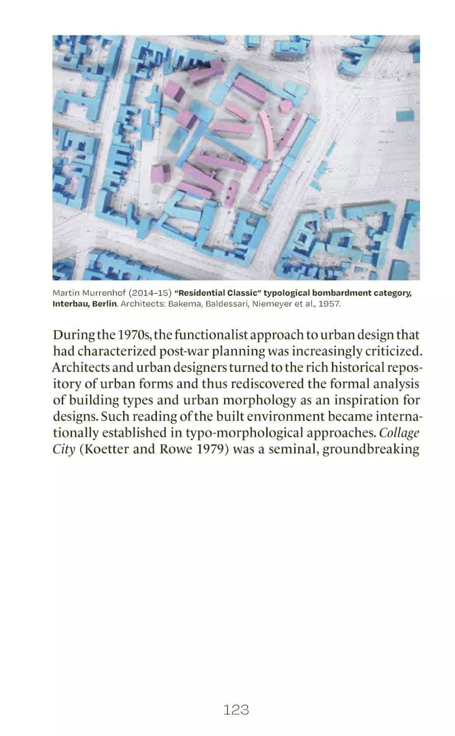
Urban Design Methods
Integrated Urban Research Tools
Undine Giseke, Martina Löw,
Angela Million, Philipp Misselwitz,
Jörg Stollmann (eds.)
# A.1
# A.2
# A.3
# A.4
urban design as a changing profession
some notes about interdisciplinarity
external statements
working across geographical boundaries:
reflecting on sino-german cooperation
in urban design
5
12
25
35
# B.0
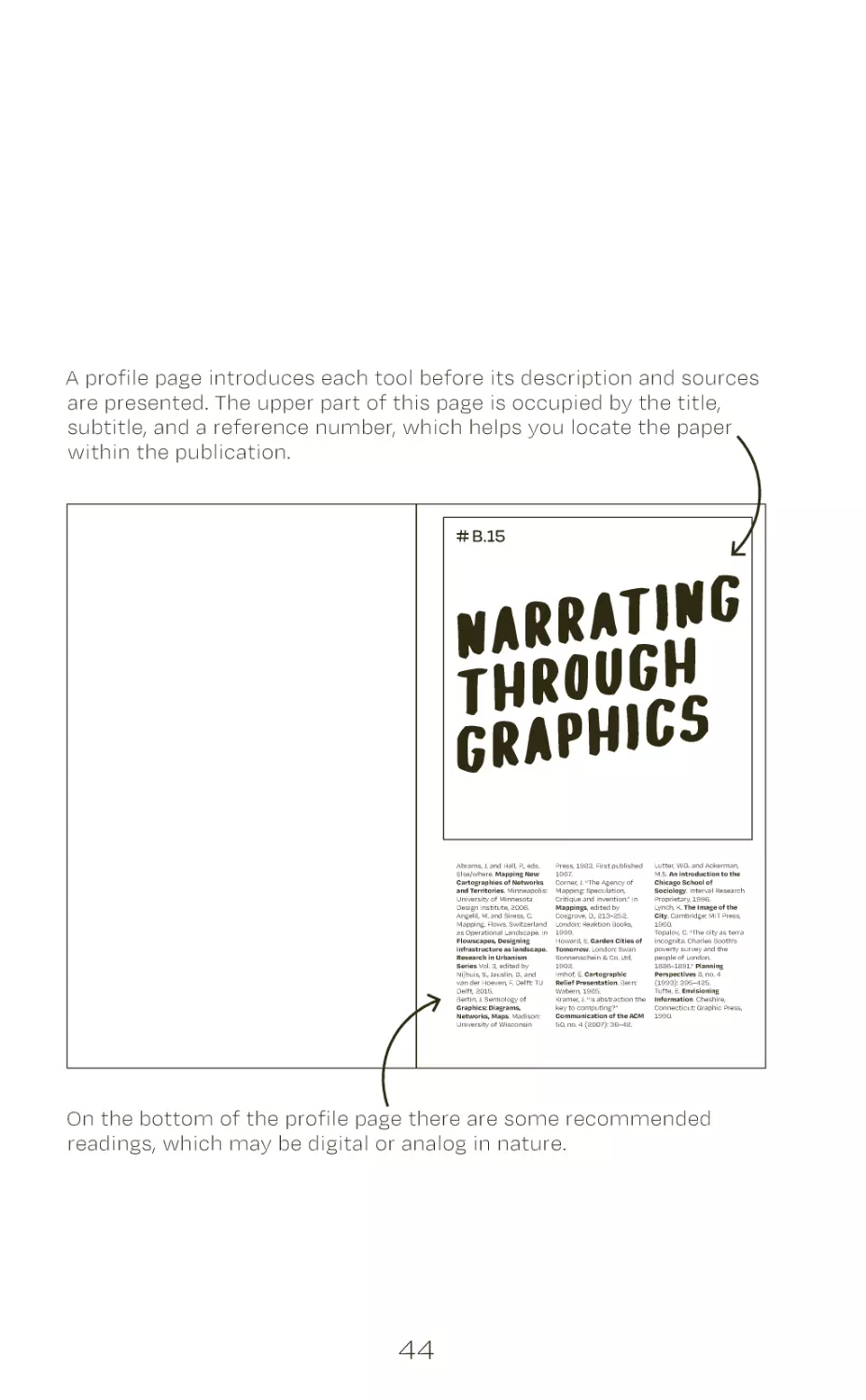
how to read this book
44
# B.1
# B.2
# B.3
# B.4
# B.5
# B.6
# B.7
# B.8
# B.9
# B.10
# B.11
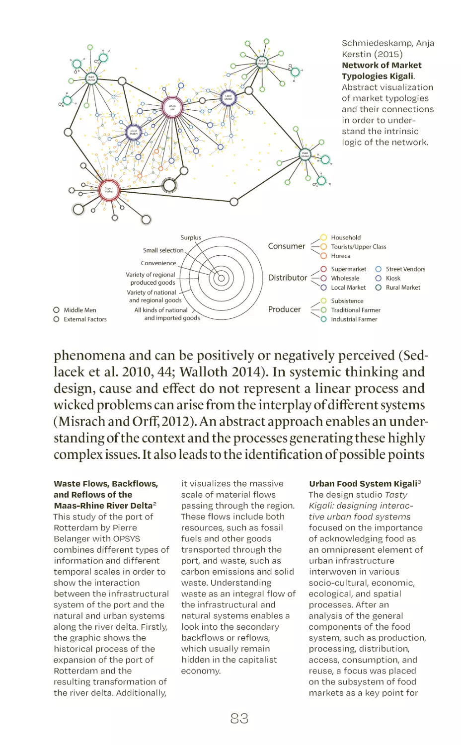
understanding spatial practices
diagrammatic sketching
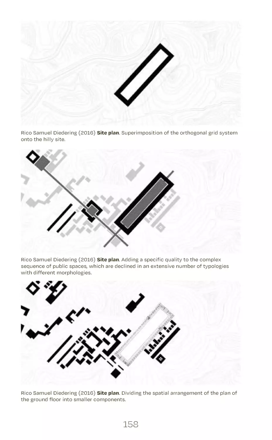
unpacking discourses
experimenting
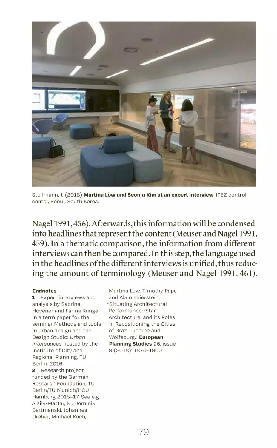
interviewing experts
mapping spatial systems
urban data mining
analyzing pictures
using questionnaires
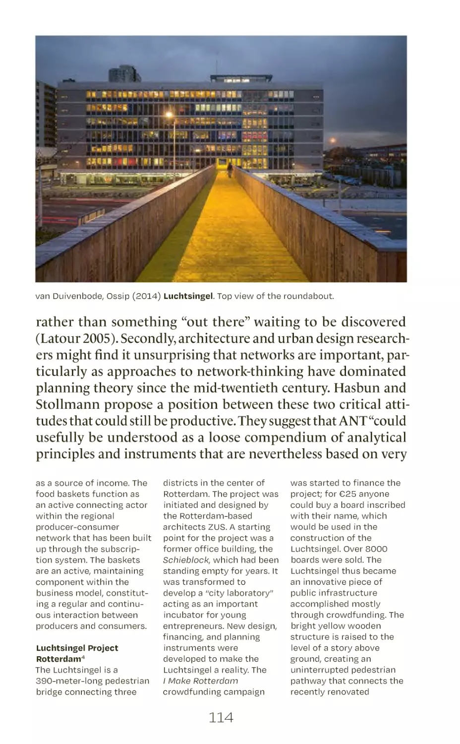
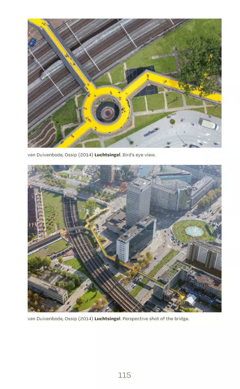
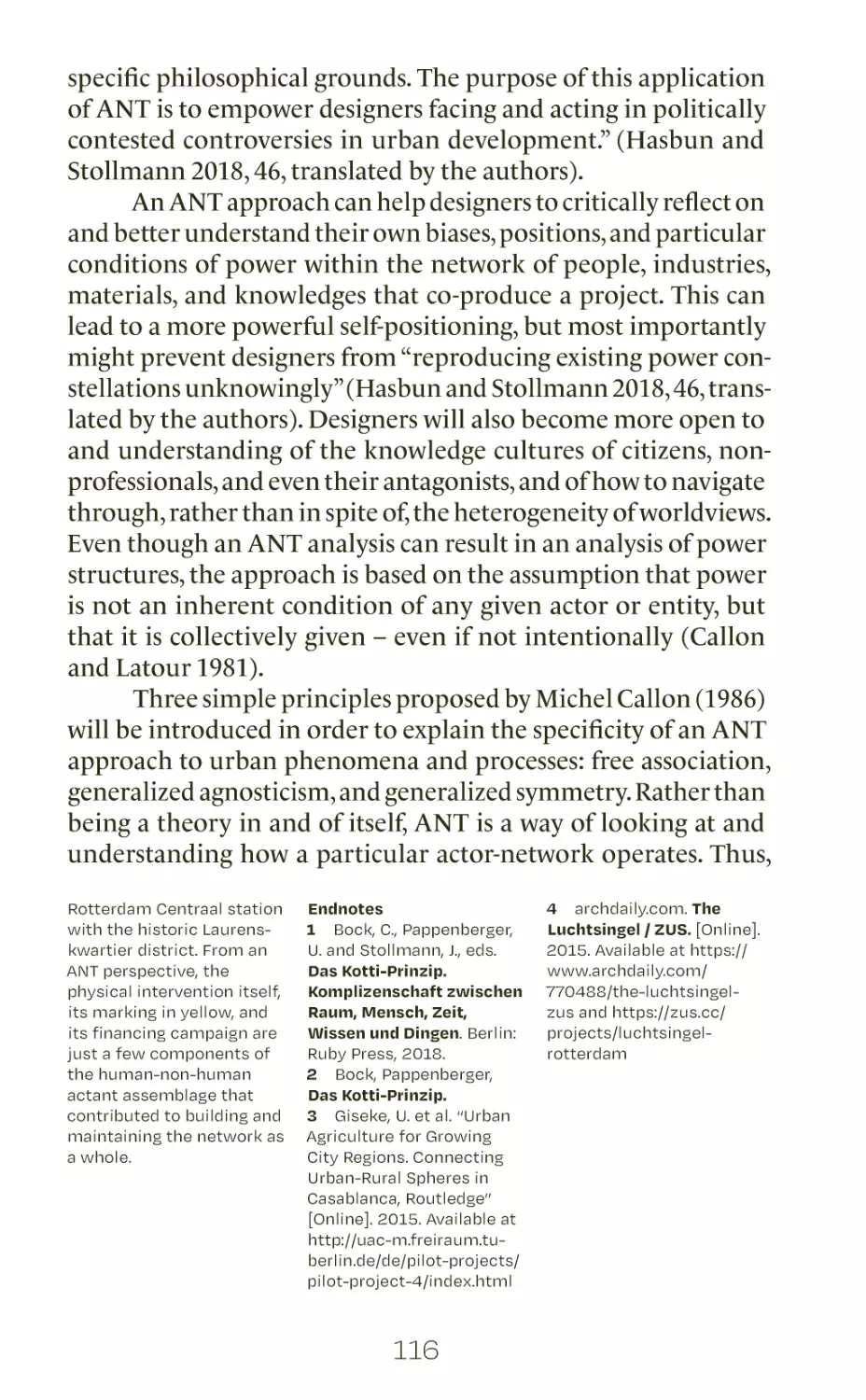
applying ANT
understanding typologies
and morphologies
viewing the urban through
an ethnographic lens
analyzing and visualizing actors
getting lost: unfolding creative thinking
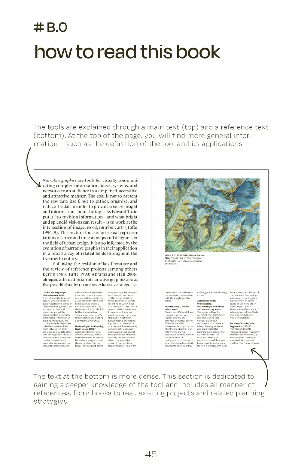
narrating through graphics
adding, dividing, superimposing
creating conceptual models
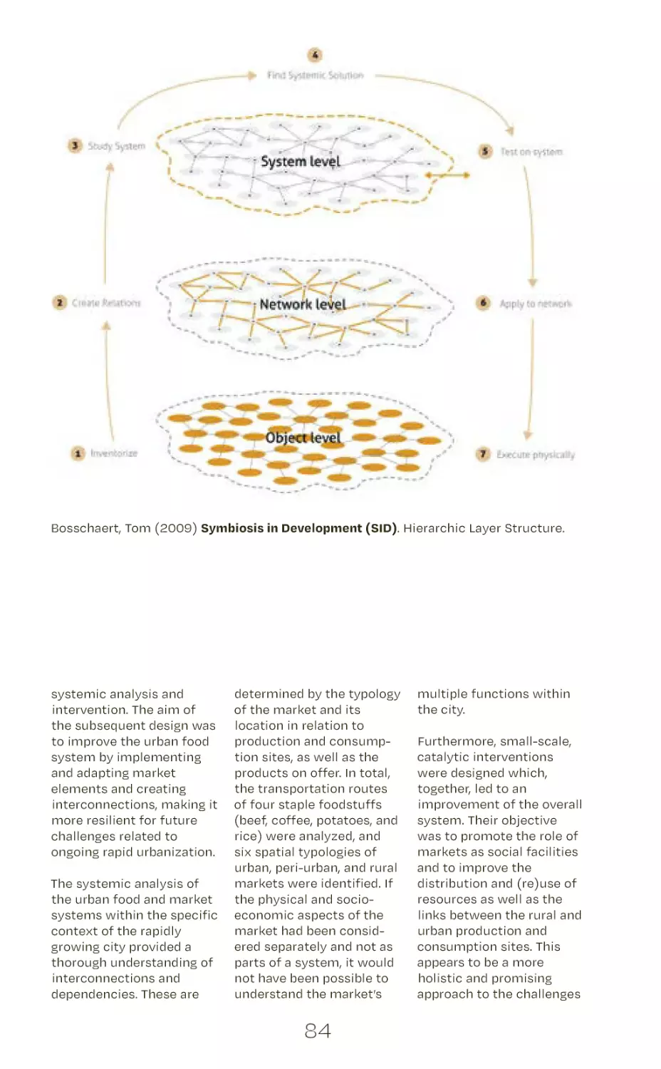
intervening through system thinking
designing grid principles
producing and reducing complexity
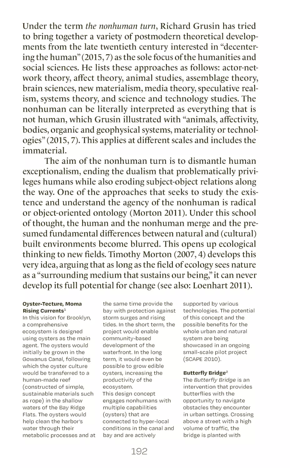
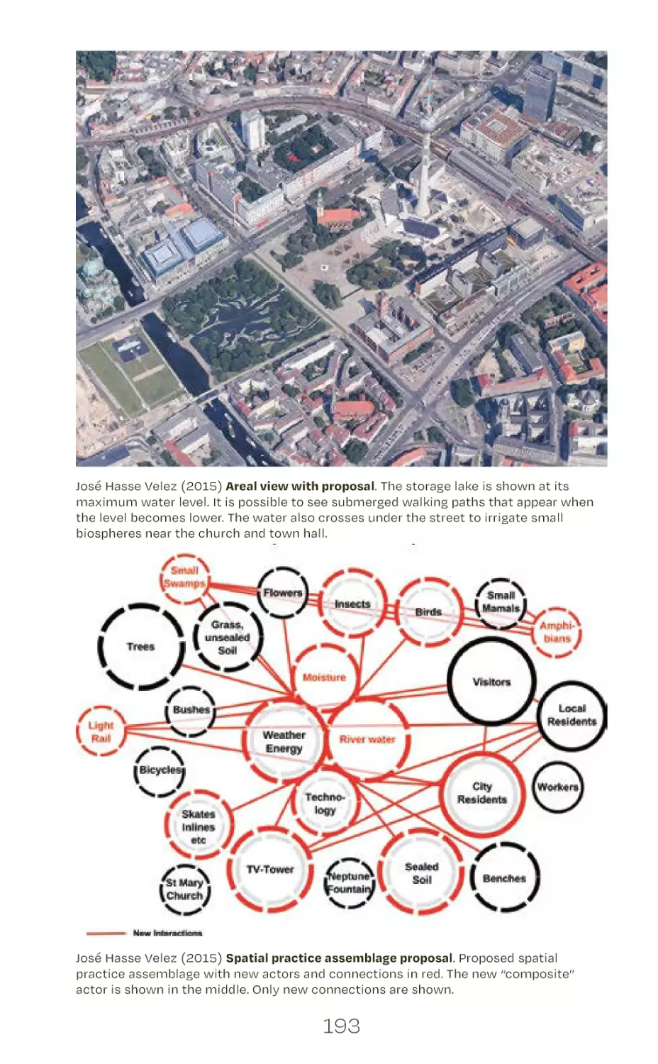
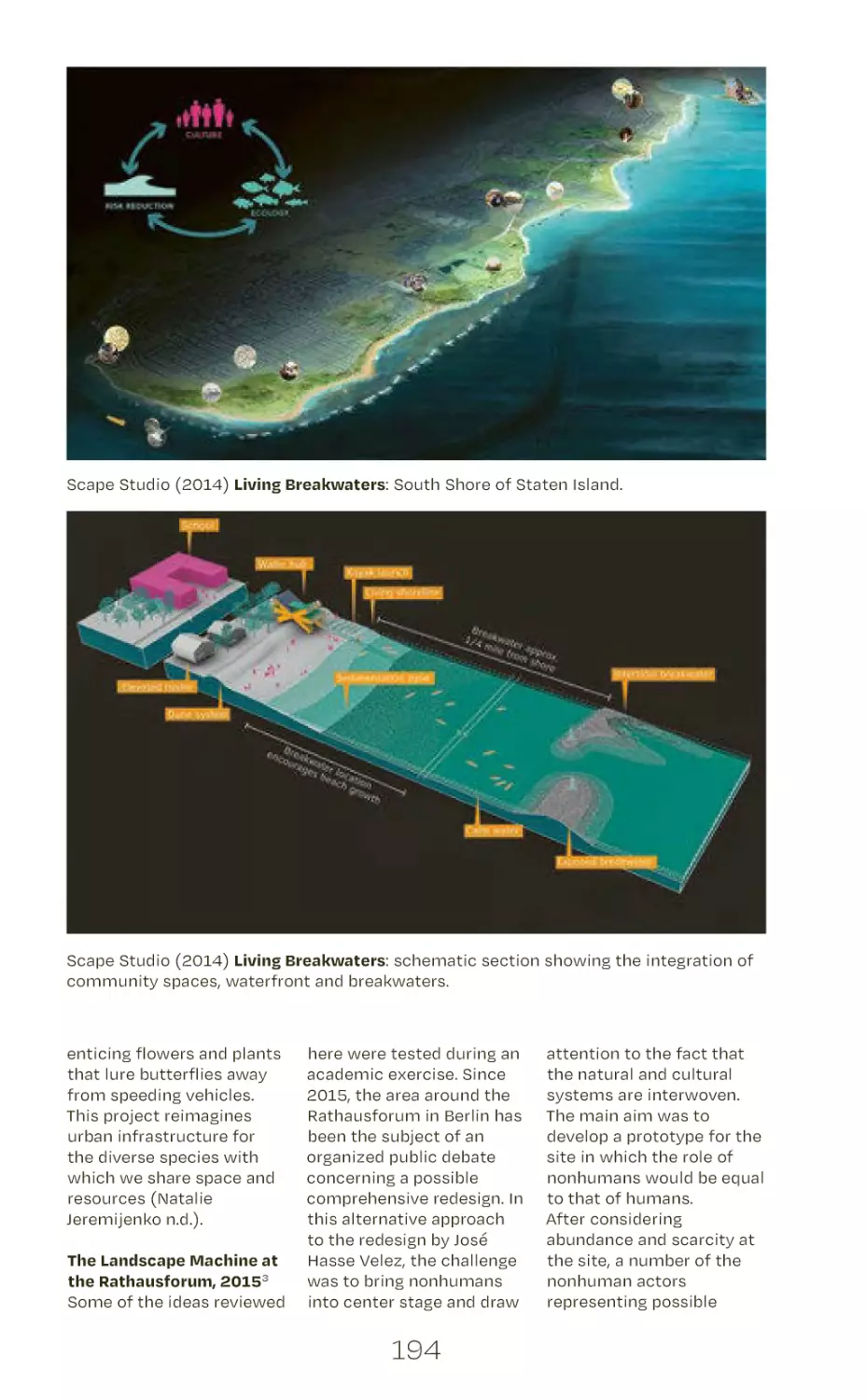
engaging humans and nonhumans in design
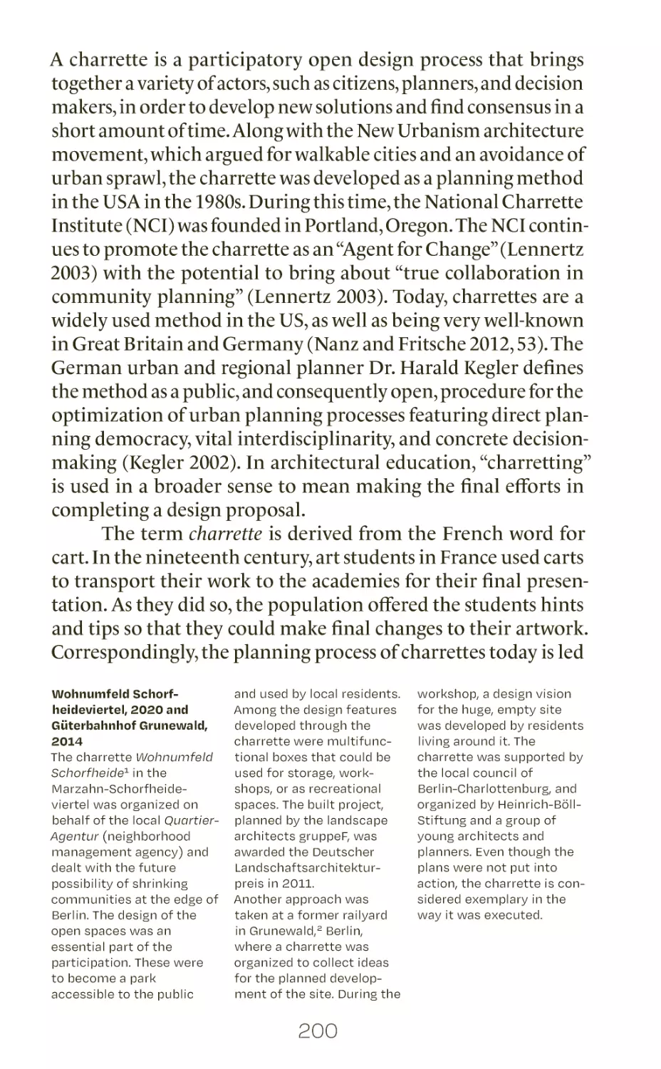
building knowledge through charrettes
participation and enactment games
visualizing possible futures
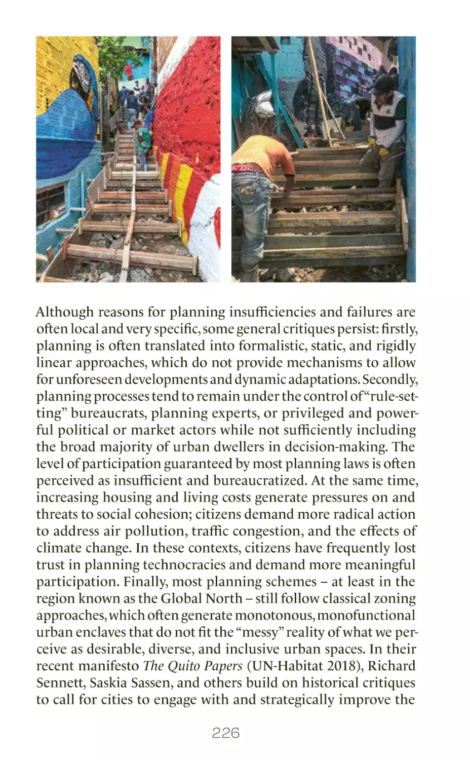
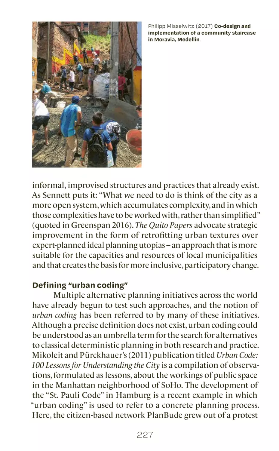
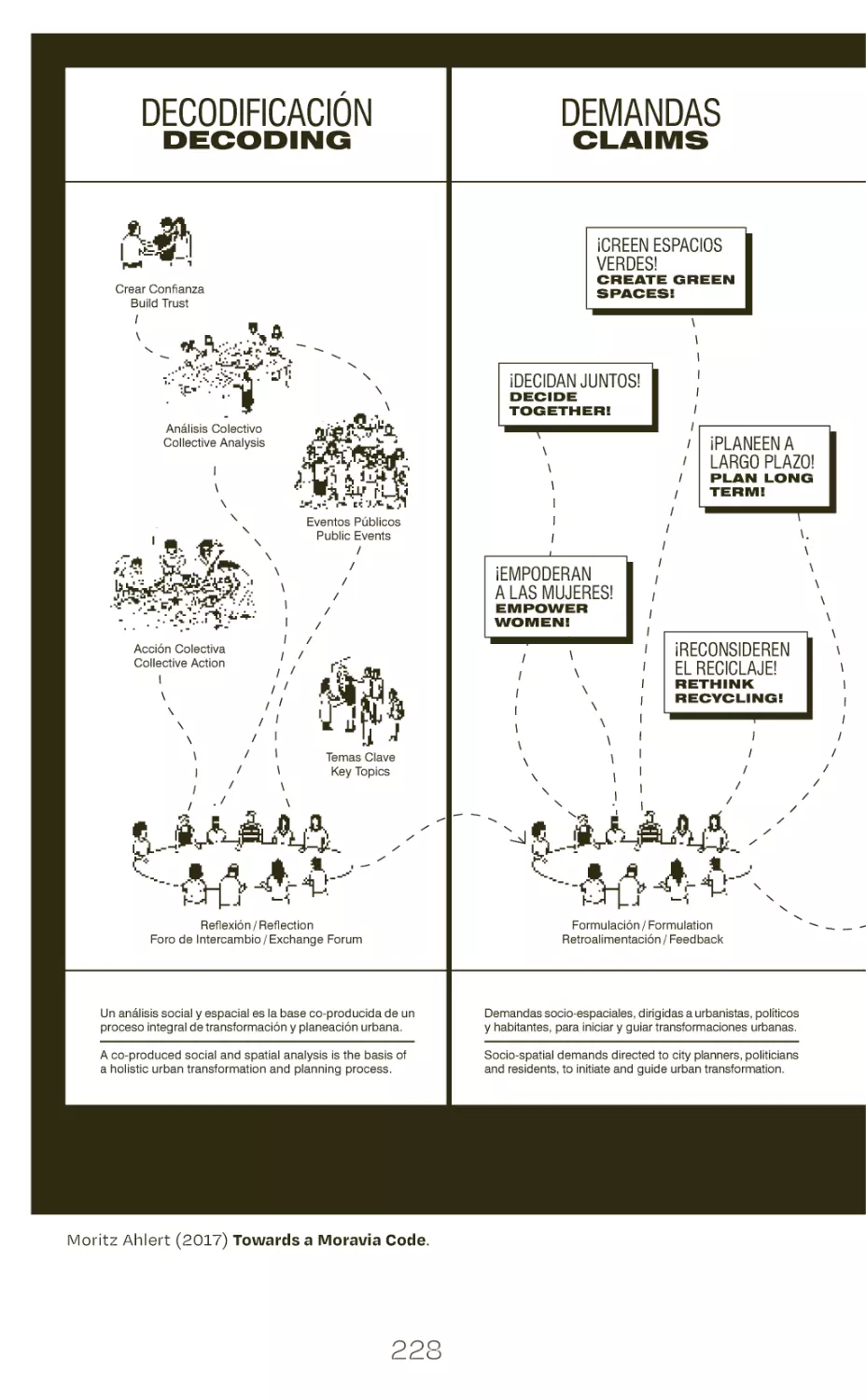
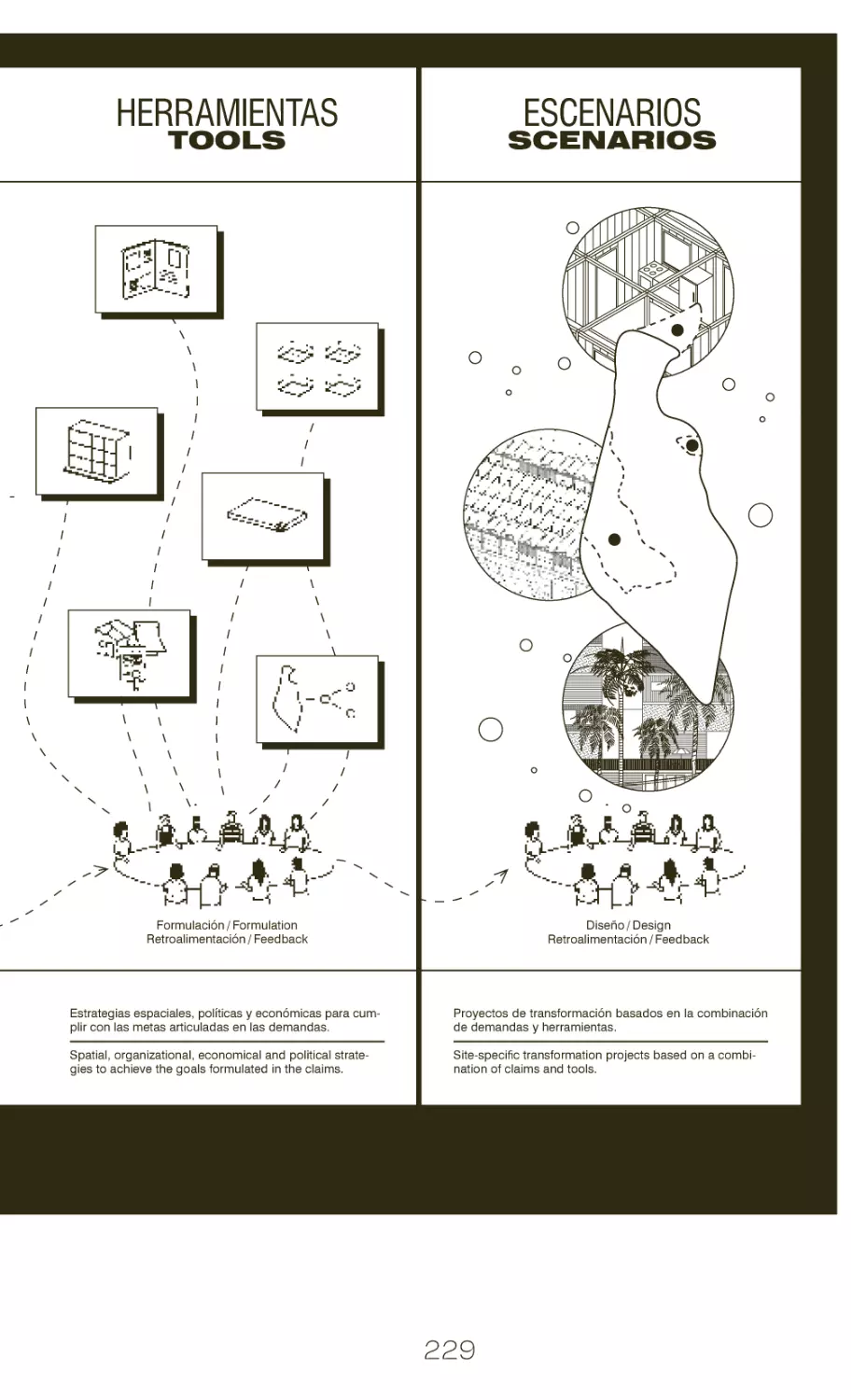
urban coding
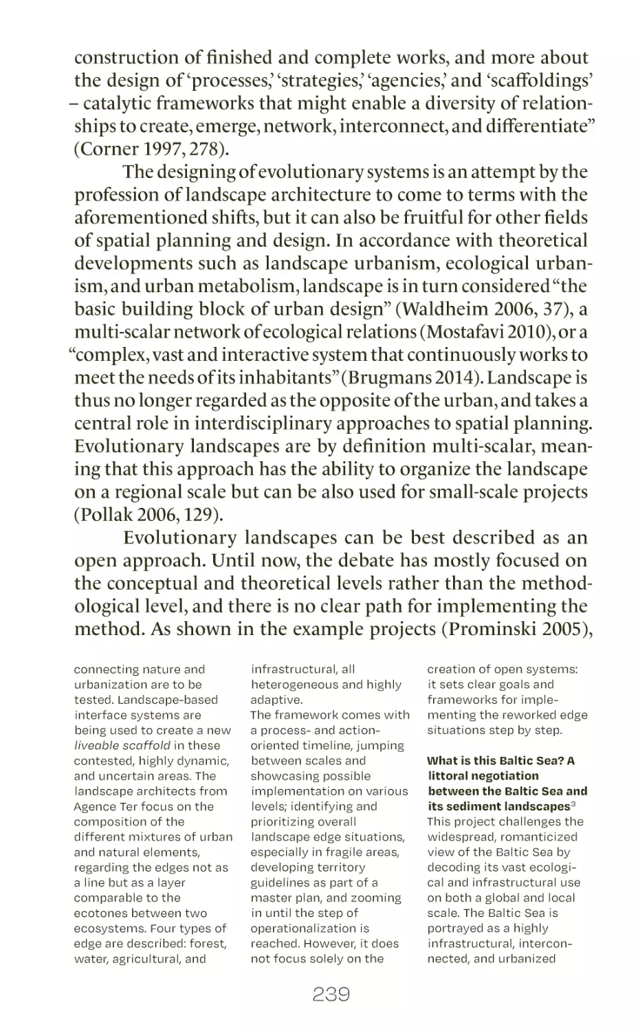
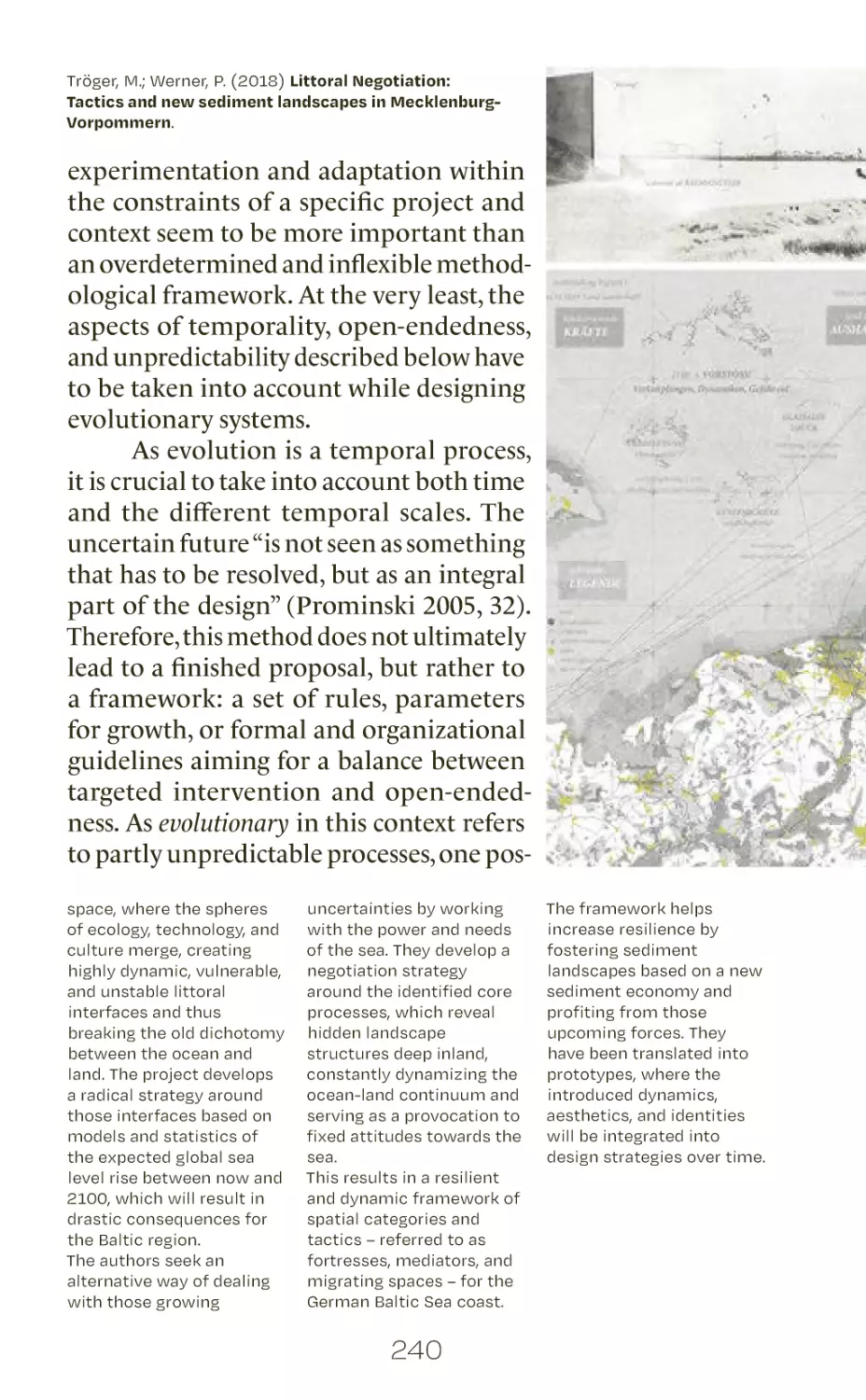
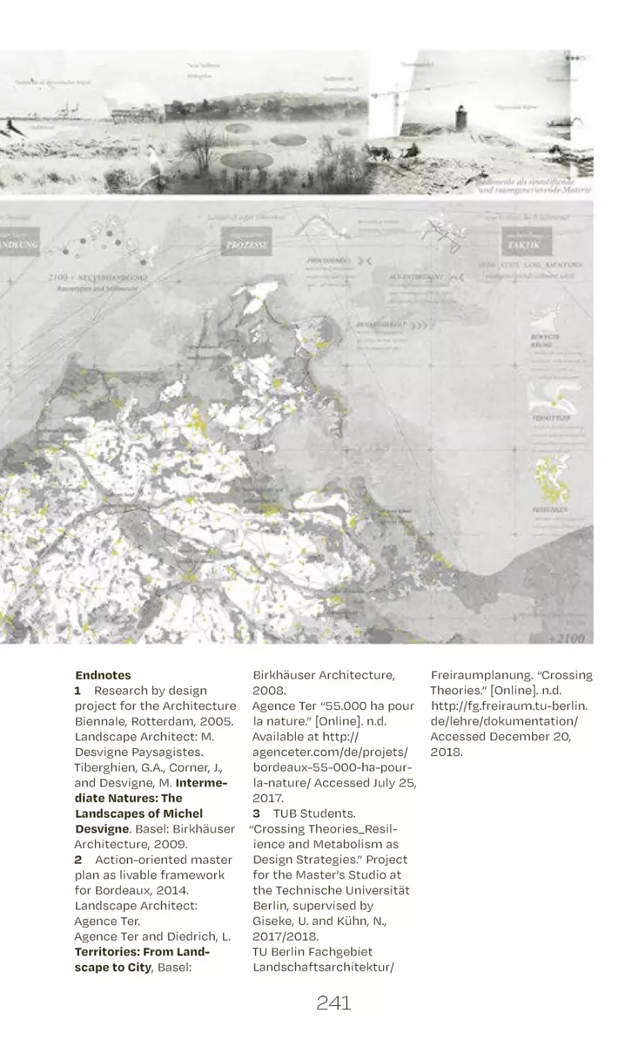
curating evolutionary landscapes
co-designing and building
47
55
63
69
75
81
89
97
103
109
119
index of authors
254
# B.12
# B.13
# B.14
# B.15
# B.16
# B.17
# B.18
# B.19
# B.20
# B.21
# B.22
# B.23
# B.24
# B.25
# B.26
# B.27
3
127
131
139
147
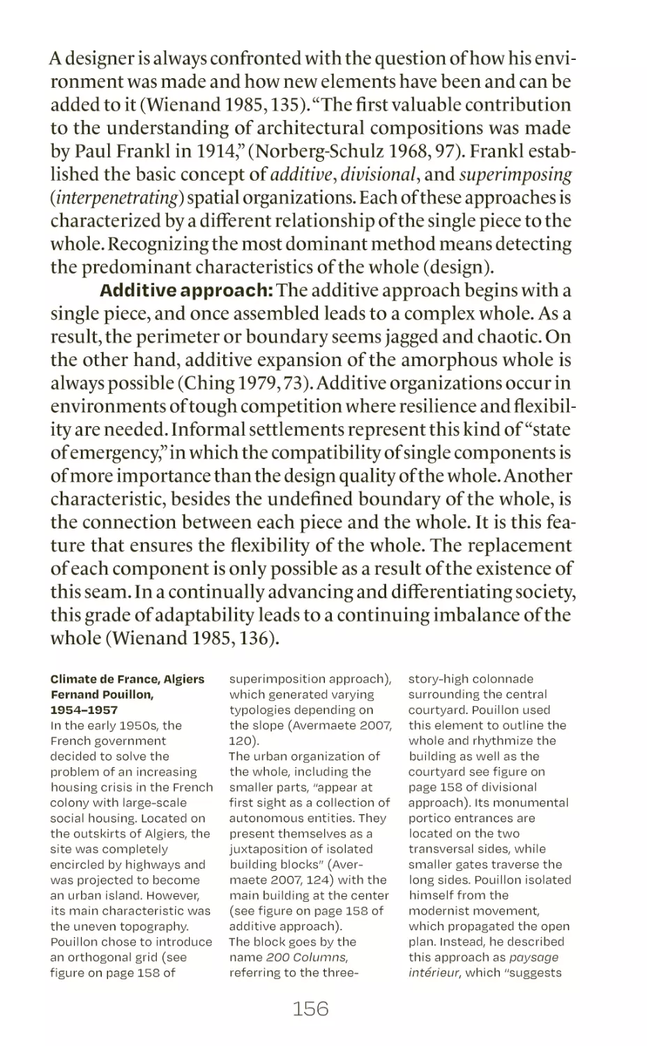
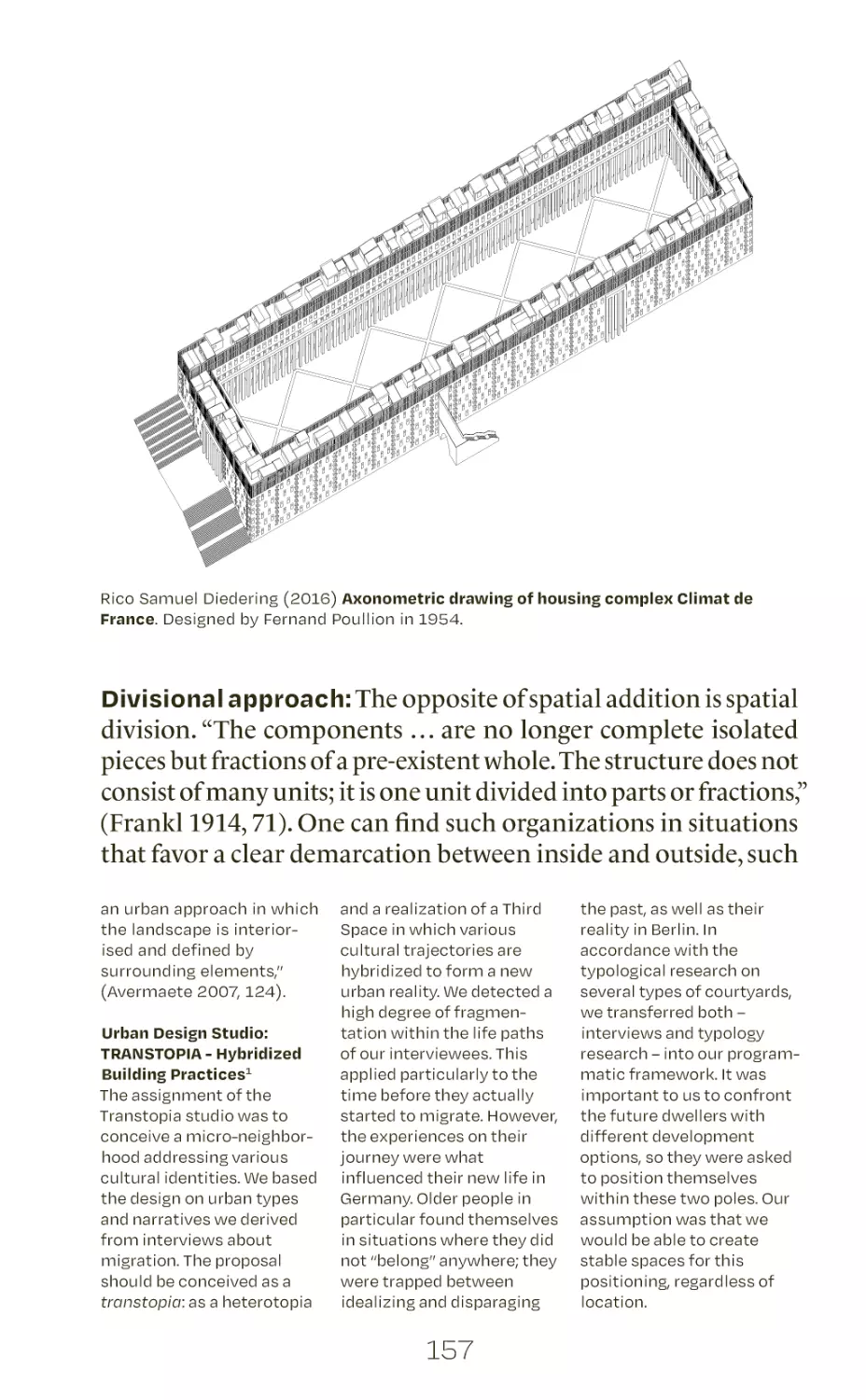
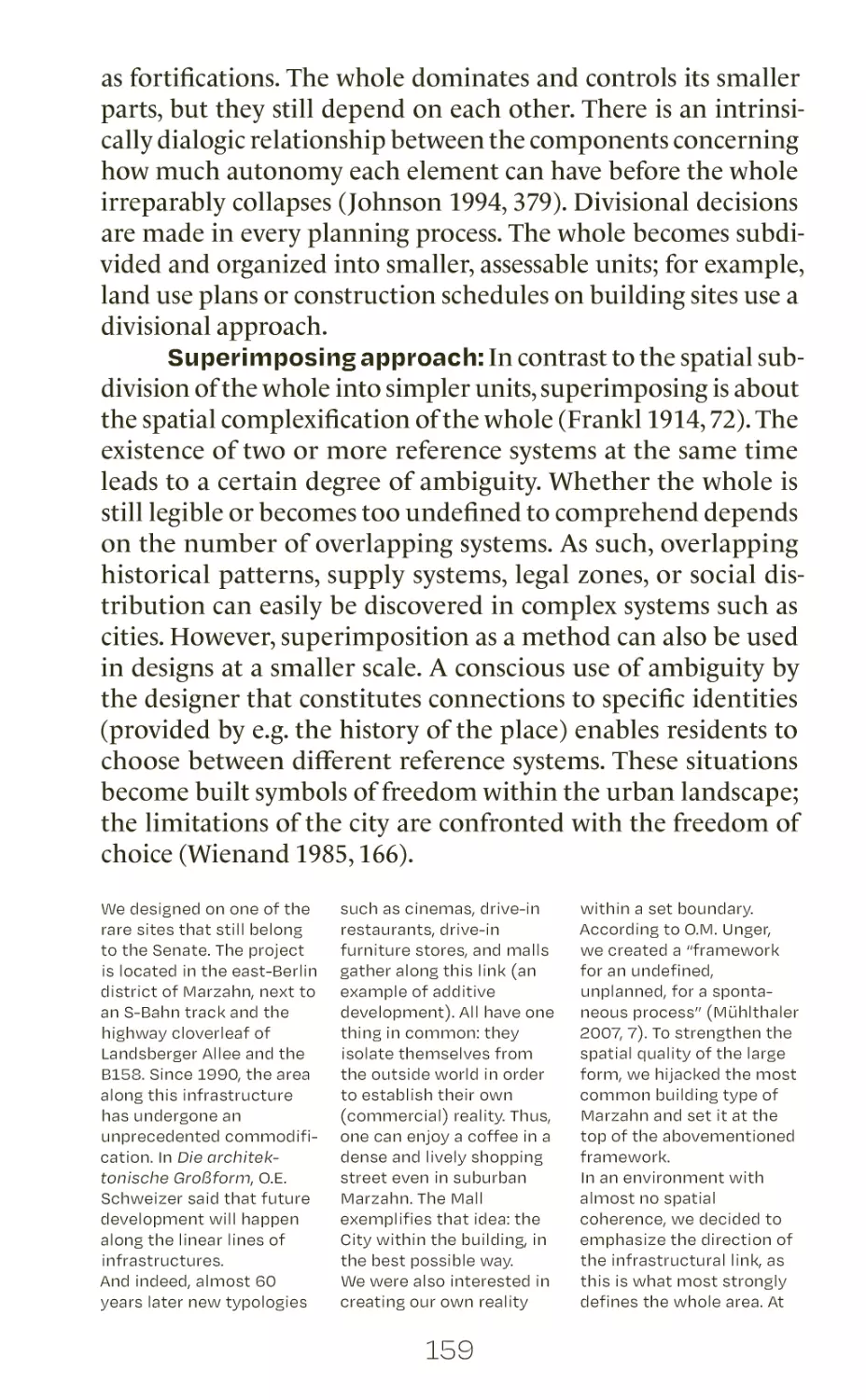
155
163
169
177
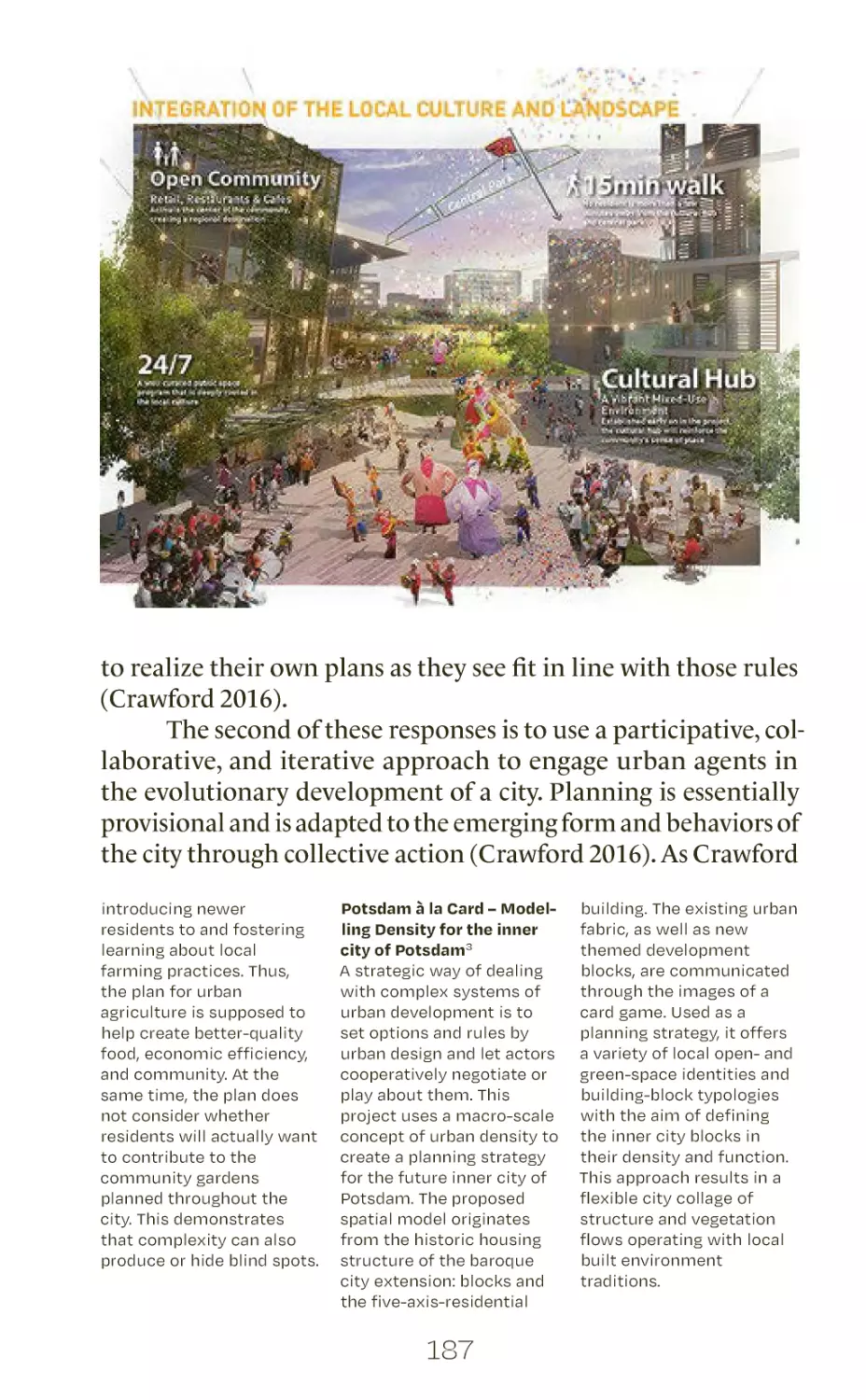
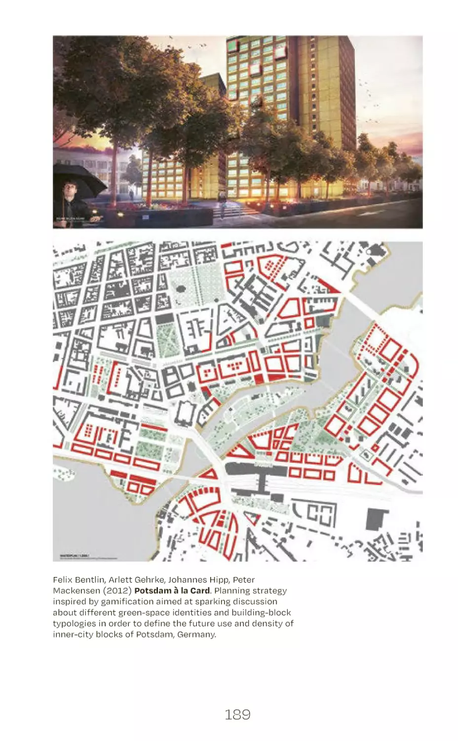
183
191
199
205
213
223
235
243
4
# A.1
urban design as a changing
profession
Undine Giseke, Martina Löw, Angela Million,
Philipp Misselwitz, Jörg Stollmann
In recent years, we have witnessed an unprecedented surge in
public, academic, and policy debates focusing on cities and
urban areas. Urbanization is seen as one of the key risks to
planetary sustainability globally, with an estimated 2.5 billion
additional urban dwellers by 2050, particularly in developing
countries, dramatically increasing carbon footprints through
the anticipated building activities and traffic, causing rising
environmental degradation through the dramatic expansion
of built-over areas, and increasing the risks and destabilization related to uneven development and new levels of expected
urban poverty. Yet at the same time urbanization continues
to produce imaginaries of hope. To most of us, cities are associated with improved and more inclusive access to resources
and policy arenas, as well as with arrangements that produce
societal innovations, including new forms of living and the
transition towards sustainability. We realize that the urban and
natural systems are inextricably linked by a complex circulation
of materials, dissolving the old categorical and spatial bound-
5
aries between the city and its “outside.” Against this backdrop,
cities and urbanization processes take center stage in political
and policy debates and ideas such as the Right to the City, the
involvement of the civil society, the decentralization of decision-making, and stronger mandates are gaining ground (see
WGBU 2016 and United Nations 2017).
Ironically, the more we talk about cities, the more we realize
how much we don’t know. Paradoxically, the growing certainty
that the city holds the key to achieving global sustainability is
paired with an increasing awareness of complexity and lack of
clarity in how we define a city or the urban on a conceptual and
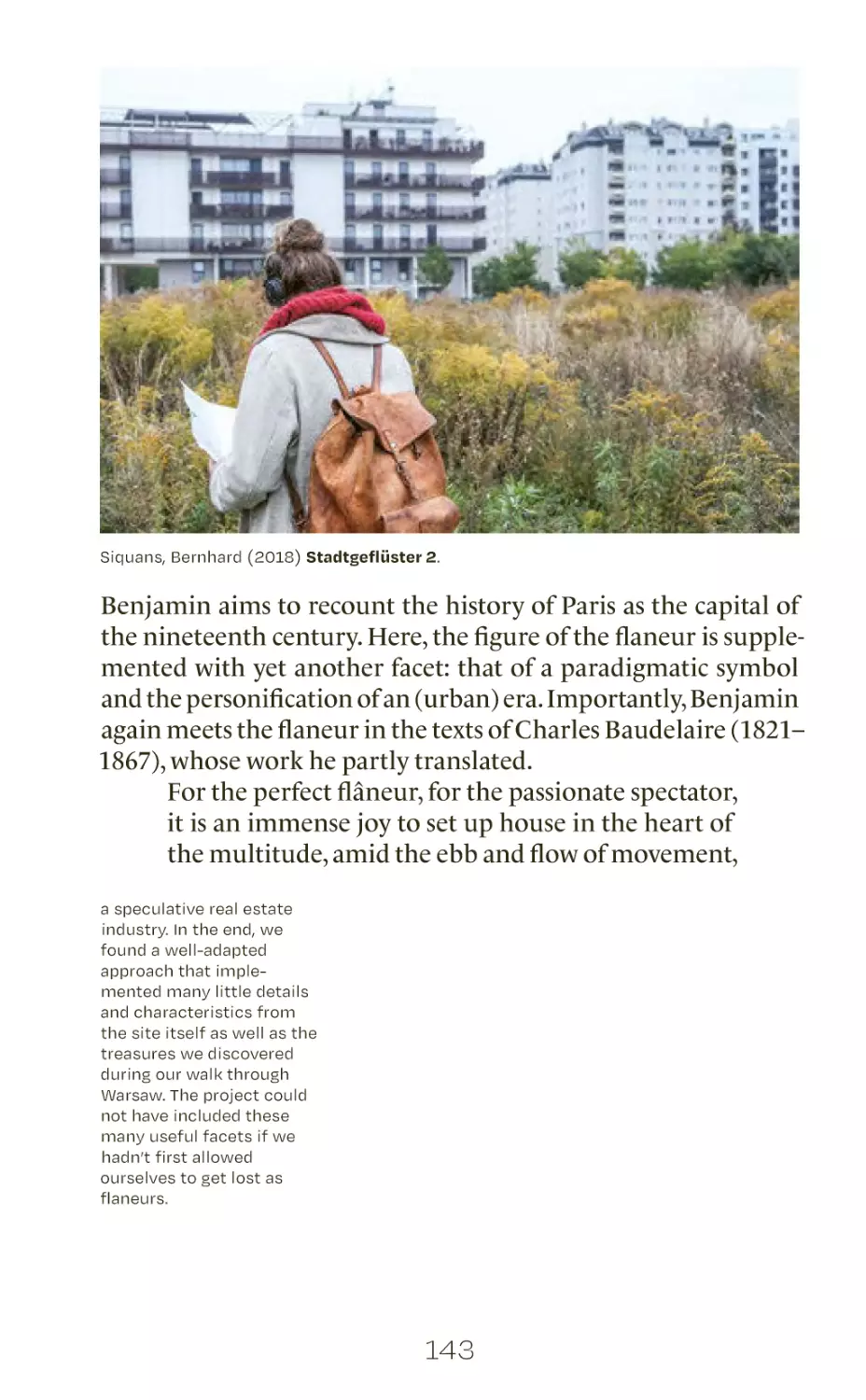
practical level. What is a city, and where do we draw its limits when
we realize that they are embedded in complex social, ecological,
and economic metabolisms and flows? How do processes of digitalization, mediatization, translocalization, and polycontextualization change the urban and our perception of urbanity? We tend
to consider urbanization as a limitless societal transformation
process at global scale – a planetary phenomenon (Brenner and
Schmidt 2014). But how can we then establish more effective
and just governance and management systems which must be
put into practice in situated political, cultural, geographic, and
social conditions?
The ongoing and profound transformation processes
challenge not only our conceptual understanding of what cities
and urbanities are, but also, crucially, the traditional urbanoriented disciplines such as architecture, urban planning, landscape architecture, spatial planning, and urban sociology. The rise
in the complexity of urban systems has fueled an ever-increasing
fragmentation of expertise and skill sets, which is further reflected
in the disciplinary fragmentation of academia. Going beyond
interdisciplinary challenges to think and act in relation to the
city, urban transformation processes force us to question the
assumed centrality of expert knowledge itself.
At a global scale, it is urban informality rather than institutionalized planning that has established ways of governance,
with urbanization shaped by the everyday actions of city-dwellers
themselves (Roy and Al Sayyad 2004). In developed countries,
furthermore, citizens are increasingly declaring their right to
fully participate in decision-making about and in the demanding
process- and actor-oriented approaches to urban development.
6
While many questions concerning the tangible effects of those
open processes are yet to be addressed, the growing number of
pioneering movements and experimental planning and design
approaches introduce alternative modes of spatial production.
Depending on the context, such approaches have drawn on local
particularities, cultural perspectives, and administrative structures; in some cities, among them Berlin, the approaches rely
on strong collaborative traditions. If the co-production of urban
space promises to be both more socially inclusive and broader
in its perspective than existing and established participatory or
bottom-up planning processes, we need a new, transdisciplinary
understanding of urban knowledge – one that includes, beyond
expert technical knowledge, a broad range of different knowledge cultures, including the embedded and situated knowledge
of citizens themselves.
Confronted with overlapping roles, and with a reality they
experience as messy, planning and design professionals often feel
overwhelmed. This volume attempts to discuss how the challenge
of gaining a broader understanding of urban knowledge, urban
co-production, and inter- and transdisciplinary research and
practice might lead to new approaches to pedagogy, research,
and design responses within critical practice. Urban design – as
an integrative field of study, profession, and course of action – takes
a clear stance for inter- and transdisciplinary co-production as
well as for a systemic understanding of the challenges of our
still-urbanizing world.
Urban Design as an Inter- and Transdisciplinary Field of
Study
In 2006, four institutes at TU Berlin – the Institutes of Architecture, Landscape Architecture, Urban and Regional Planning,
and Sociology – started a joint teaching experiment. They established the MSc in Urban Design program as the first interdisciplinary urban-oriented master’s of its kind in Germany, based on
the assumption that mono-sectoral approaches are insufficient in
preparing young professionals for the ever-increasing complexity
of urbanization and a radically transforming field of practice.
In the program, urban design is understood as a new field of
reflection and practice in which multiple disciplinary approaches
converge, and where, therefore, new didactic approaches are
7
required in order to build appropriate capacities and develop
creative solutions.
We benefit from the well-established wealth of methodological expertise and know-how within each of the four distinct disciplinary traditions. Their specific methods are adept
at covering the concise and isolable aspects of the urban, while
the common work across disciplinary boundaries reveals the
interdependencies of urban dynamics and allows us to combine
both basic and applied research approaches in teaching practice.
This applies, for example, to our attempt to bridge the
conventional gap between the social sciences and design disciplines. We deny any hierarchical relationship between observing, non-normative social sciences and projective, implementation-oriented urban design. Instead, we orchestrate conversation
and cooperation between participants in order to expand the
range of insights. The urban designers thus gain a better awareness of how to generate and deal with data and empirical material
in order to understand their subject. Urban design is in need of a
methodological debate to scrutinize its ways of knowledge generation and, in turn, strengthen its accountability and possibilities
for critique. In parallel, social science methods often fall short
when it comes to a spatialized understanding of reality. Through
cooperation with urban designers, social scientists are introduced
to the non-linear and iterative modes of urban, architecture, and
landscape design processes and the ways in which they impact
the production of space.
This volume presents the most important insights, gained
in the form of methods and tools developed through this integrative work at the intersection of the disciplines. While some of
these insights refer back to long-standing traditions, others reach
out to emerging schools of thought. The overview is necessarily
extensive, but despite this is still not comprehensive.
Co-producing Space, Co-producing Knowledge
While the production of urban space is expected to steer
towards inclusivity in democratic discourses, basic professional
education is only now starting to query the contested socioeconomic and political conditions within which design tasks are
situated. Uncovering the frequently naturalized – yet intrinsically
political – dynamics of gentrification, privatization, and financial-
8
ization at the root of urban transformation cannot rely solely on
multidisciplinary expertise, nor on tapping local actor-specific
knowledge. It requires the co-production of knowledge from
within a constellation of different actors and networks. We therefore foster this understanding in the urban design field of study
by way of a co-operational, multi-scalar, and trans-disciplinary
approach.
In the long-winded processes of co-producing knowledge,
the resource of time emerges as the main challenge. In conditions
of rapid change, the need for readily available and assimilated
databases and methodological tools for sourcing, analyzing and
interpreting qualitative and quantitative data is crucial. This is
precisely one of the issues that this volume, as well as the overall
urban design curriculum, aims to address.
Urban Design as a Diversifying Profession
Are planners and designers inevitably condemned to always
lag behind and be only retroactively asked to intervene? Or is
it in fact possible to reconceptualize the city as a contested field,
and to deliberately choose and shape one’s own role, scope, and
range of responsibilities – including by identifying potential
alliances and sites of intervention? The disparity between education and profession is hard to ignore. Urban design as a field
of study addresses the complex socioeconomic, political, and
ecological conditions within which professional actors act in
order to reframe the urban designer as a trans-disciplinary urban
professional. To that end, we must also question the frequently
privileged social and educational background of the designers
themselves, which is often disconnected from the everyday life
of most of the citizens they plan and design for. Urban design as
a course of action starts with reflection and introspection long
in advance of a specific commission.
Design as Transformative Knowledge Production
Part of this introspection should be directed at one’s own
design attitude. Shaped by individual background, history, and
experiences, the designer’s attitude and agency have to be put
under closer scrutiny, especially as they become part of academic
knowledge production in research-based design or researchby-design projects. The designer’s attitude and agency can be
9
critically examined not only through the lens of theoretical perspectives, but also against the real, transformative outcomes of a
specific design task. As convoluted and opaque as it may at first
seem, design ultimately brings about a tangible, physical change
and a sense of purpose; this need to be reflected upon, negotiated,
and made transparent.
Notwithstanding our insufficient knowledge of the world
that we aim to transform, we as urban designers are confronted
with the very real consequences of current forms of design practice on the built environment. Alongside other methods of complexity reduction, we promote a systemic understanding of spatial
phenomena that accounts for a variety of interrelated factors,
which may range from the local up to the planetary scale and
involve the socioeconomic, political, and ecological spheres. The
aim of a systemic understanding is to identify possible points
of intervention where design, even as a small-scale change, can
resolve a specific problem and simultaneously have far-reaching
transformative effects.
Having abandoned the illusion of a universal framework
for action, urban design faces an overwhelming task; diverging
and fragmented operating practices create further structural
obstacles. This volume’s main contribution is to collect a range
of current practices and decipher the underlying methodological thinking; it offers an orientation, embraces the multitude of
perspectives, and ultimately hopes to provoke reflection on one’s
own role, frame of action, and attitude. As such, this volume is
a repertoire of instruments and tools with broad disciplinary
origins. These tools have been applied in project- and researchbased teaching within the curriculum of the MSc in Urban Design
in order to foster and advance the attitudes that trained urban
professionals carry to the field of practice. We are convinced that
the field of Urban Design will become a key arena in helping to
find creative and locally appropriate answers for steering and
shaping our cities and urbanized regions towards sustainability
and social justice.
10
Brenner, N. and Schmid, C. “The ‘Urban Age’ in Question.” In Implosions/Explosions.
Towards a Study of Planetary Urbanization, edited by N. Brenner, 310–337. Berlin: Jovis
Verlag, 2014.
Brenner, N. and Schmid, C. “Towards a new epistemology of the urban?” City 19, issues
2–3 (2015): 151–182, DOI: 10.1080/13604813.2015.1014712
Brenner, N., Schmid, C. “Planetary urbanization.” In Urban Constellations, edited by
Matthew Gandy, 10–13. Berlin: Jovis, 2012.
Roy, A., AlSayyad, N., eds. Urban Informality: Transnational Perspectives from the Middle
East, Latin America and South Asia. New York: Lexington Books, 2004.
WBGU – Wissenschaftlicher Beirat der Bundesregierung Globale Umweltveränderungen.
Der Umzug der Menschheit: Die transformative Kraft der Städte. Berlin: WBGU, 2016.
United Nations. New Urban Agenda. [Online]. 2017. Available at www.habitat3.org
Accessed April 22, 2020.
11
# A.2
some notes about
interdisciplinarity
Future Urbanists: Embrace Complexity,
Co-Make Flexible Pluralities.
Andreas Brück
Today we live in liquid times (Baumann 2000) where a mode of
constant crisis triggers small, short-term, and ad-hoc answers to a
multitude of problems – financial crises, housing crises, climate
crises, sociopolitical crises, and their manifolds. In a modern
age focused on quantification and standardization, we struggle
to deal with uncertainty and complexity. However, urban professionals “should not claim the instant ability to solve complex
problems” and instead “be exploratory and inclusive” (Hall and
Tewdwr-Jones 2010, 268).“Planning is becoming plural” as “drivers
of change … are transforming the activity and scope of planning,
across scales and across territories in varied ways and at varied
times” (Hall and Tewdwr-Jones 2010, 268, emphasis added). Rather
than “solution-thinking” that fosters simplifications, we need creative ideas that embrace complexities. The more options we have
the more powerful our cities will become. But are we prepared
for this? Do we have the necessary knowledge and tools? How
12
are multiplicity and diversity managed? How are planetary and
localized scales mediated and created?
Urban design practice has to become more flexible and
cities thought of as “unfinished” frameworks that encourage individual creativity and ownership to authorship. As many examples of contemporary community-based initiatives prove, the
challenge is chiefly procedural and not ideological. It is largely
dependent on forging new approaches, with new methods, new
behaviors, new schemes, new setups, new strategies… A long time
ago, in the final chapter of Cities and the Wealth of Nations, Jane
Jacobs advocated for drift – “a process of continually improvising”
(1961, 221–222). And in the 1970s, Durth called for a transition
towards an “aesthetics of improvisation” (1976, 194) in urban
design education and practice accentuating the potentials of
reuse, mixed use, programmatic design, and a public takeover of
streets, plazas, and parks. Today, urban design practice has still
not systematized this goal.
Nevertheless, new ideas regarding the practices of urban
design and related fields are venturing into unfamiliar domains,
calling for reforms, adaptations, and revolutions in the way cities
are made. In order to navigate urban complexity and uncertainty,
urban professionals need to not only understand the urban and
its contextual conditions, but also to normalize engagement in
envisioning urban tomorrows, and to assist in their re-grafting and
remaking. The professional mastering of a wide range of methods
and tools is of quintessential importance to urban design practice,
which requires drawing on contexts encompassing multiple sets of
(un)knowns, parameters, projections, and speculative designs. In
the best-case scenario, imaginaries, anxieties, demands, and multiple perspectives on tomorrow’s cities may be re-appropriated,
amalgamated, and recombined innovatively into rooted, original hybrids. Insights from different domains (e.g. traditionally
walled-in disciplines) prompt the conclusion that cities are able
to develop not only one way or the other, but also into amalgams
of formerly incompatible opposites.
As Mau phrases it, in these liquid times “the challenge of
our era [is]: to synthesize incredibly complex inputs and reconcile
those inputs into one coherent way of proceeding” (Mau in Hyde
2012, 30). With this in mind, the expectations of future urban
professionals (of whatever disciplinary flavor and whether of theo-
13
retical or activist commitment) are high. Meanwhile, the expertise
and experience necessary to catalyze urban change, weave together
and amalgamate hybrid spaces, and navigate the multiplicity and
plurality of urban tomorrows is not easily achieved.
Today, urban professionals need to comfort and reassure
themselves with regard to their capabilities and options – including their methods and tools. What is necessary is a reconquering
of the urban in terms of both discourses and physical manifestations; a fearlessness in attempting daring proposals for non-linear
solutions that understand progress as the ability to simultaneously produce plural, creative, adaptable, and procedurally flexible flows of operations. On top of this, future urban professionals
need to become better at understanding, communicating, and
mediating different points of view. This relates to necessary new
roles for urban professionals as curators, catalysts, and facilitators;
roles that focus on implementing and nurturing elements that
empower communities to forge and cater for liveable urbanities
themselves. As Indy Johar puts it:
This is a future in which architecture and our role as
designers are changing; we are being invited to be
protagonists, to be the change-makers and the propositioners. This is a future where we must become the
makers of platforms – not the designers of containers
for corporations. This is a future where, to evoke
Cedric Price, we must be operational and innovative,
and build social ecosystems. (2014, 204)
It is obvious that the education of future urbanists should be
adapted to contemporary trends. Since everything is becoming
more fluid and less permanent, and is in a state of constant adaptation, the education of urban professionals needs to follow suit –
it must come out of the campus and into the urban. Knowledge
concerning elasticity should become a core topic in academia,
and methods of putting it into practice need to be developed and
tested. Education needs to offer overviews of and training in the
skills required for orientation, navigation, and pathfinding while
accepting and employing complexity as a resource. We should
be trained to ask divergent questions following dynamic inquiry
methods that create variations, alternative answers, and scenarios
for possible procedures rather than fixate on static knowledge
for a “road map” or an “end product.”
14
And even then we should not forget to constantly revise and
reflect; even at times of accelerated speed, ultra-complexity, fast
decision-making, and so on, we must carefully and continuously
recalibrate what we do, learn, and teach – as well as the methods
and tools we use.
Bauman, Z. Liquid Modernity. Cambridge: Polity Press, 2000.
Durth, W. “Zur gesellschaftlichen Funktion von Kritik und Theorie des Stadtgestaltung.”
PhD diss., Technische Hochschule Darmstadt, 1976.
Hall, P. and Tewdwr-Jones, M. Urban and Regional Planning. London: Routledge, 2010.
Hyde, R. Future Practice. Conversations from the Edge of Architecture. London:
Routledge, 2012.
Jacobs, J. The Death and Life of Great American Cities. New York: Random House, 1961.
Johar, I. “Architecture of the Civic Economy.” In Make Shift City. Renegotiating the Urban
Commons, edited by Ferguson, F., 204–205. Berlin: Jovis, 2014.
15
Urban Design as an Interdisciplinary Inquiry
Emily Kelling
Urban and spatial studies are currently marked by recognizable
gaps; firstly, between the different disciplines in the social sciences
and humanities (Robinson 2002), and secondly, even more fundamentally, between the social sciences and the design disciplines
(Fiori and Brandão 2010). The latter especially poses a challenge
for urban design – at least if it is conceived of as sitting at this
interface. However, urban design may also be predisposed to help
with narrowing this gap. One avenue for doing so is to develop
a research perspective for the spatial that recognizes the value
of the knowledge-generating capacities of each discipline and
the potential of their synergies. The premise is that both sides
of the gap can benefit from the other, that urban dynamics can
be understood better if both sides come together sensibly, and,
finally, that such a perspective can contribute a new quality to
the addressing of urban social problems.
This aim requires an in-depth engagement with the
diverse methods of spatial analysis and knowledge generation.
For one, design methods such as sketching need to be taken seriously for their knowledge-generating capacities. At the same
time, the process of knowledge generation needs to be described
so that its procedures and limitations, as well as its results and
their specific context of emergence, can be discussed. This would
eventually lift the meaning of the spatial understanding gained
beyond the design itself. Similarly, the relevant methods from
the social sciences and their methodological premises need to be
made comprehensible on a level that makes them employable
for design researchers without gross simplification. This would,
first of all, provide a basis for the joint discussion of research
results. Subsequently it may provide for the synthesis of diverse
approaches into a joint perspective both for research and for the
praxis of design and the politics of space.
16
When it comes to the ambition of bridging the interdisciplinary
gap within urban design, the German academic system poses a
somewhat peculiar complication. This is the rather rigid organization of the various traditional disciplines, which is also to be
found at the Technische Universität Berlin. The Urban Design
master’s program is not offered by one institutionally identifiable
entity within the organigram, but instead by a range of chairs
from four significantly separated university departments who
collaborate to offer the study program and to develop a joint
Urban Design agenda. It is my impression that in the Anglophone
realm – within urban studies but also beyond – it is more common
than in Germany to approach academia from an interdisciplinary
perspective. In this, interdisciplinarity itself has acquired a different meaning. The difference is one of a discipline-based versus
a problem-based research approach. In the Anglophone realm,
the traditional disciplines more commonly receive less emphasis
than in Germany. This finds expression in the institutional set-up
of universities, insofar as the differentiation of departments and
study programs often follows a topic-based logic. It allows an
approach to research and teaching that is based on a fusion of
perspectives in which traditional disciplines cease to be of primary significance. In Germany, by contrast, disciplines remain
the organizing principle in many cases, and interdisciplinarity
usually means bringing together researchers with rather clear
disciplinary positions, often confronting the individuals involved
with the challenge of mutual incomprehensibility. Both modes
have their advantages.
Looking in particular at the study of urban development
and urban design, a discipline-based approach seems almost
counterproductive in face of the complexity of cities and the
historic evidence of the negative consequences of sector-based
policies. Upon closer inspection, however, it turns out that the
problem-based approach also takes its toll. Even if architects
and designers have been among the driving forces of interdisciplinary Anglophone thinking in urban development, design,
and environmental studies, this often seems to have been at the
expense of their design skills. One can better grasp the meaning
and implications of the “despatialization” of the debate (Fiori and
Brandão 2010) when considering the potential that the German
organizational set up – despite all its challenges – affords; that
17
is, the collaboration between social scientists, architects, and
planners who still consider themselves as such and who therefore have retained the specific qualities and capacities of their
individual disciplines.
This dilemma has turned into an exciting task that we are
addressing in the configuration of our program. In the sociologybased Introduction to Urban Design we draw on the sociology
of space in order to develop the theoretical skills needed to read
the social and spatial structures within which urban design interventions unfold. This includes a focus on social inequalities and
their spatial (re)production. We use this perspective to reimagine the kind of impact an intervention can have, thus theorizing about the political potential of urban design. Moreover, in
cross-disciplinary teaching and research projects, we have started
bringing together the various relevant methods of the different
disciplines and discussing them in a comparable format in order
to develop a shared language. Indeed, I would argue that such a
shared language is the core of any ambition to achieve the synergy
of the disciplines. A shared and non-hierarchical language is the
precondition for a true understanding of the others’ work and
aims. This, in turn, is key for the recognition of the equal value of
the specialized skills and knowledge generated in the different
disciplines. Only when all three conditions are achieved can the
potential of mutual complementarity and synergy be understood
and realized. This is a question of politics significant not only to
the context of research, to which I refer primarily, but also to the
praxis of design and the production of the city more generally.
Fiori, J. and Brandão, Z. “Spatial strategies and urban social policy. Urbanism and poverty
reduction in the favelas of Rio de Janeiro.” In Rethinking the informal city: Critical
perspectives from Latin America (Remapping Cultural History, Volume 11), edited by
Hernández, F., Kellett, P., and Allen, L.K., 181–206. New York: Berghahn Books, 2010.
Robinson, J. “Global and World Cities. A view from off the Map.” International Journal of
Urban and Regional Research 26, issue 3 (September 2002): 531–554.
18
What Ever Happened to Landscape?
Making the Case for New Disciplinary and Material
Intimacies
Xenia Kokoula
What ever happened to landscape?1 The discipline of landscape
architecture has long grappled with the dichotomy of nature
and culture, which positioned the city firmly in the latter category. The last decades have brought a host of challenges, too
numerous to discuss in full, that bring this core dichotomy into
question. Theorists have pointed out that “nature cannot pre-exist
its construction” (Haraway 1992, 296); as a result, we have become
“excruciatingly conscious of nature’s discursive constitution as
‘other’” (Haraway 1992, 296). Human activities – both in their
discursive dimension but primarily in their material impact –
are understood as geological forces of planetary transformation,
introducing the era of the Anthropocene (Renn and Scherer
2015). Global phenomena, such as conflict, migration, climate
change, and natural disasters massively reshape territories. Their
undeniable and forceful materiality makes clear that we lack
adequate tools to debate and deal with them (Hekman 2010).
Recent developments in landscape architecture, such as
landscape urbanism, ecological urbanism, and urban metabolism,
can be understood within the context of the aforementioned
challenges. Not all of them question, let alone effectively deconstruct, the separation between nature and culture. However, they
have succeeded in expanding the disciplinary boundaries and
generating an active debate with the potential to invigorate the
disciplines that deal with the urban territory. These schools of
thought share as a starting point the understanding that landscape, ecological, and metabolic processes are a driving force in
urban transformation (Waldheim 2006).
Firstly, as landscape urbanism makes clear, we need to look
beyond architectural objects as the single, human-made structural
19
units that cumulatively shape our living environment (Waldheim
2006). Architecture and the city are just some of the building
blocks that interact with natural phenomena and ecological processes to form larger systems. Accordingly, these systems are not
limited to the traditionally dense urban settlements; they expand
far beyond them to include rural spaces, as well as spaces that are
not used as human settlements in the traditional sense, but are
still intrinsically connected to them – such as infrastructure or
bodies of water. Based on this understanding, ecological urbanism
stands for a holistic, regional, and global approach to dealing with
interrelated design problems including housing, environmental
issues, access to food, water and energy, and other resources. These
problems, however, cannot be resolved independently by the
respective specialized subfields. Urban metabolism thus promotes
a way of thinking in processes and flows, rather than in static
spatial designs (Sijmons 2014). It seeks not only to reveal hidden
or obscure spatial processes, but also to intervene in the natural
and/or urban systems they sustain.
Even a very brief overview of landscape urbanism, ecological urbanism, and urban metabolism reveals two related points.
On the one hand, urban and natural systems, the city, and the
landscape cannot be explored separately but only through their
multiple connections. As a consequence, disciplinary boundaries
need to be questioned in practice and in academia, as we do in
the Urban Design master’s program. The focus on landscape does
not seek to establish a new hierarchy or privilege one discipline
over the others. The separate disciplines still serve an important
role as repositories of specialized knowledge. At the same time,
designers such as James Corner (2014) and Kate Orff (2012) are
carving innovative cross-disciplinary methodological paths for
engaging with urban and natural systems in the context of specific
but complex problems: the urban metabolism in the harbor city
of Rotterdam in the first case, and the petrochemical landscape
of the Mississippi river in the second.
Following Timothy Morton and his consideration of intimacy, we understand our task as a radical search for integrating
what at first seems incompatible; “an exercise in hubris” (2010,
273). Intimacy is understood in a material sense as the interdependence and inseparability of different materialities, life forms,
and species. A further example of intimacy is the concept of
20
zero landscape, which seeks to erase the outdated concept of an
aesthetic distance between the human viewer and the surrounding landscape (Morton 2011). Last but not least, Morton is an
advocate of a radical disciplinary intimacy, one that not only
occasionally straddles boundaries but links disparate fields at
their very foundations (Morton 2010).
Different forms of and platforms for such meetings across
disciplines are currently being tested both in and outside of the
academic world. The aim is to study and uncover the interaction
of heterogeneous components in urban and natural systems, their
human actors and the matter (food, water, energy etc.) that sustains them, along with other non-human forces as diverse as animals, affects2, and technologies (Grusin 2015). The recent debates
in landscape architecture have already succeeded in making such
elements the focus of design, thus bringing the urban and natural
sphere closer together. It is now time to fully acknowledge the
functional and conceptual inseparability of urban and natural
systems (Giseke 2018) in order to turn our imaginations to the
challenges of the Anthropocene.
FABRIC and JCFO. “Project Atelier Rotterdam.” In IABR 2014 – Urban by Nature, edited by
Brugmans, G. and Stein, 164–179. Rotterdam: IABR, 2014.
Giseke, U. “The City in the Anthropocene—Multiple Porosities.” In Porous City. From
Metaphor to Urban Agenda, edited by Wolfrum, S. et al., 200–204. Basel: Birkhäuser, 2018.
Grusin, R. Introduction to The Nonhuman Turn, edited by Grusin, R., 7–29. Minneapolis:
University of Minnesota Press, 2015.
Haraway, D. “The Promises of Monsters. A Regenerative Politics for Inappropriate/d
Others.” In Cultural Studies, edited by Grossberg, L.; Nelson, C.; Teichler, P., 295–336. New
York: Routledge, 1992.
Hekman, S. J. The material of knowledge. Feminist Disclosures. Bloomington: Indiana
University Press, 2010.
Koolhaas, R. “What Ever Happened to Urbanism?” In S, M, L, XL, edited by O.M.A., Koolhaas,
R., and Mau, B., 959–971. New York: The Monicelli Press, 1995.
Misrach, R. and Orff, K. Petrochemical America. New York: Aperture, 2014.
Mostafavi, M. “Why Ecological Urbanism? Why Now?” In Ecological Urbanism, edited by
Mostafavi, M. and Doherty, P., 12–53. Baden: Lars Müller Publishers, 2011.
Morton, T. “Queer Ecology.” Publications of the Modern Language Association of America
125, no. 2, (2010): 273–282, https://doi.org/10.1632/pmla.2010.125.2.273
Morton, T. “Zero Landscapes in the Time of Hyperobjects.” GAM Graz Architecture
Magazine 07, (2011): 79–87.
Sijmons, D. “The Urban Metabolism. Introduction.” In IABR 2014 – Urban by Nature, edited
by Brugmans, G. and Stein, J, 120–122. Rotterdam, IABR, 2014.
Waldheim, C. (2006): “Introduction. A Reference Manifesto.” In The Landscape Urbanism
Reader, edited by Waldheim, C., 13–19. New York: Princeton Architectural Press, 2006.
Endnotes
1 This question paraphrases Rem Koolhaas, who a few decades ago called for a
rethinking of urbanism in the face of global, unrestrained, and rapid urbanization
(Koolhaas 1995). Arguably, landscape architecture is ready for a similar rethinking.
2 Unlike the more subject-oriented emotions, affects imply “an intensity moving
through human and nonhuman bodies alike” (Grusin 2015)
21
The Turn of Theory: Urban Design at the University
Áine Ryan
Within the academic context, methods and their epistemological
groundings define disciplines. In the practice context, corresponding professions are largely defined by the scope of their services.
Urban design straddles these realms, albeit with an inherent bias
towards “practice over theory” or “profession over discipline.” It
originated as a field of practice, but continually draws on theoretical positions from across the social, economic, and environmental
sciences: mostly as an aid to understanding the urban condition,
sometimes, perhaps, to bolster its legitimacy as a distinct field of
activity or profession, and sometimes to advance the tools of its
trade. The establishment of urban design as a stand-alone curriculum at universities over the past decade or so brings with it the
opportunity for a more critical and consequential engagement
with theory. Significant potential exists at universities such as
TU Berlin, where the curriculum is delivered as a cross-faculty
collaboration, simply because interdisciplinary conversation is
conversation about methods.
Achieving such a conversation about “method” is not without significant challenges, especially for design disciplines. Design
theory is comparatively scant; urban design theory is even more
so. That said, a recent argument against the comparison of urban
design with empirical sciences introduced a promising definition
of urban design knowledge as “a particular form of diagrammatic
socio-spatial knowledge that cannot be reduced to either words or
numbers” (Dovey and Pafka 2015). This epistemological framing
resonates with the design theory strand on “designerly ways of
knowing” (Cross 1982) that sees design as “a third way” distinct
from the humanities and social sciences (Nelson and Stolterman
2012).
To date, most reasearch on the methods and modes of
design knowledge build upon Herbert Simon’s examinations of
the role of representation in design problem-solving from the
22
late 1960s (Akin 2001). Rooted in the computational sciences, and
typically framed as protocol studies of design exercises at the scale
of architecture, this avenue of enquiry has articulated quite well
how drawing and sketching cognitively assist designers in both
grasping and solving complex problems: by abstracting and typifying information to trigger, order, develop, test, and refine ideas
(Goldschmidt 1991). Yet despite this ‘visual thinking’ being the
backbone of design theory to this day, designers themselves have
scarcely contributed to this body of research. For example, little
is empirically known about the types of information selected
to solve specific design problems and how the substance of this
information is changed in various stages of the design process, or
about the typical types of judgements that underpin key decisions.
This is probably because design is mainly learned implicitly “by
doing,” and without being taught about its scientific grounding
or methods. Nevertheless, it is remarkable that fifty years after
Simon began the design theory conversation, and twenty years
after digital tools began to significantly alter the hand-to-head
heuristics that underpin “visual thinking,” even the field of design
theory needed to be reminded that “design is not simply ‘itself’ but
is the interplay (or in my language the mediation) between subjects and the substantive, real-world, essentially artificial, subjectmatter with which it engages”, and that knowledge of this mediation is still “in embryo” (Dilnot 2018, 145). This is the great
opportunity for urban design at the university. By attempting to
describe the “situated negotiating of the incommensurables involved
in moving from ‘existing to preferred situation’” (Dilnot 2018, 144),
the urban design discipline could advance more robust epistemological underpinnings that contribute to the aforementioned
critical areas of design theory and also inform approaches in
urban design practice.
As in other design fields, “representation” is the main
method of carrying out urban design, but it is next to impossible
to “do” urban design in the intuitive and non-reflexive manner
usual to “designing”: sites must be “read” at many geographical
scales; “solutions” must account for multiple sociopolitical aims
concerning the environment, human well-being, and urban quality; the often conflicting agendas of numerous interest groups
must be considered; delivery timeframes run into decades and
must integrate with ongoing cultural, historical, economic, and
23
ecological processes; and so on. “Negotiating” this degree of complexity forces more conscious thinking, as well as a retraceable
decision-making sequence, and thus lends itself more easily to
examination. Though the lens of “diagrammatic socio-spatial
knowledge,” such examinations may reveal the transformations
made to the diverse types of qualitative and quantitative information selected, weighted, synthesized, and produced in the
design process.
In this regard, the TU Berlin Master in Urban Design provides a seminal space for exploring urban design knowledge. The
core Method and Tools module conditions students to critically
compare methods across the “urban” disciplines. The Urban
Design Studio module gives a first-hand introduction to thinking through “representation” and the “situated negotiations” that
underpin the design process. The culture of openly questioning
the role and tools of urban design, if explored through scientific
research, could enable a truer synergy between theory and practice to emerge from this newest moment of urban design at the
university.
Cross, N. “Designerly ways of knowing. Design discipline versus design science.” Design
Issues 17, no. 3 (Summer 2001): 49–55.
Dilnot, C. “Thinking design. A personal perspective on the development of the Design
Research Society.” Design Studies 54 (2018): 142–145.
Goldschmidt, G. “The Dialectics of Sketching.” Creativity Research Journal 4, issue 2
(1991): 123–143.
Nelson, H. G. and Stolterman, E. The Design Way. Intentional Change in an Unpredictable
World. Cambridge: MIT Press, 2012.
Dovey, K. and Pafka, E. “The Science of Urban Design?” Urban Design International 21,
issue 1 (2016): 1–10.
Akin, Ö. “Simon Says. Design is Representation.” Draft paper, School of Architecture,
Carnegie Mellon University, 2001. http://users.metu.edu.tr/baykan/arch467/Readings/
AradSimon.pdf Accessed March 28, 2018.
24
# A.3
external statements
Global urbanization is the key driver and geographical form of what
has been called the Anthropocene, the proposed name for the era of
human-induced transformation of the environment. Considering that
urbanized and natural environments are irrevocably interwoven in
deteriorating metabolic relationships, it might be more accurate to
speak of what geographer Erik Swyngedouw has identified as the
Urbicene, to implicate urbanization as the primary driver of anthropogenic climate change. However, additionally taking into consideration
that urbanization processes are the prime expression of accelerated
capitalist accumulation, circulation, and uneven development, other
scholars – such as environmental historian and political economist
Jason W. Moore – have been prompted to recast our common predicament with the more nuanced and connective concept of the Capitalocene. These three notions converge on the diagnosis that the world’s
environment, planetary urbanization, and globally integrated market
capitalism are locked in an intimate symbiosis that is indeterminate
and far from stable.
Marc Angelil and Cary Siress
Chair of Architecture and Design at the Institute for Urban
Design at ETH Zurich; Senior Design Researcher at Future
Cities Laboratory Singapore and at ETH Zurich
The complexity of urban challenges and the disciplines and practices
that deal with them represent the paradoxical encounters between
disciplinary knowledge, aesthetic regimes, spatial conditions, and a
series of governmental forces. As such, the urban is shaped by
certain material practices and normalized through design and the act
of designing. This means that design and designing are separated
neither from the politics they emerge from, nor from the politics they
produce. As such, thinking about an urban design as the project for a
city means thinking about it in a heterodox manner: not limited to the
physical dimension, not exclusive to the activities of a professionalscientific elite that frames the space in which society is produced
and reproduced. The concept of a plan itself, of design understood as
25
a tool for imagining a future and as a path to achieving it, must be
understood in relation to a global situation of inequality, social
trauma, and environmental and social vulnerabilities of marginalization and exploitation. Imagining future urban possibilities must start
by recognizing the greatness of the small gestures and efforts, the
interstices and the potentialities, that collective actions have in thinking and modifying space and territory. The project here is not a
master plan, but must be configured as an architecture of engagement: a form of situated, dialogic, relational process (where once we
would have just talked about participation) that makes spatial
practice and intervention in space both a criticism and a hope.
Camillo Boano
Professor of Architecture and Urban Design (Icar14),
University of Turin
In practice, urban design deals with structural elements in the urban
context. These organized elements are presented morphologically,
encompassing political, economic, social, ethical, aesthetic, and
technical features.
The operation can be understood at both two-dimensional and
three-dimensional levels. Firstly, urban design sets up an overall
urban structure at the two-dimensional level, in which all the significant urban elements – such as streets, squares, parks, and important
buildings – can be integrated. Secondly, urban design defines the
form of urban open space and buildings at the three-dimensional
level. The typology of urban architecture is the decisive element in
urban spatial quality, which is presented by the relations between the
buildings.
In contrast to architectural design, urban design focuses on
urban space, the invisible part of the urban texture.
Yongjie Cai
Chair of the Architectural Faculty, College of Architecture
and Urban Planning (CAUP), Tongji University
When we observe a building, we observe it embedded in its local
context. But we are aware of the fact that, down-scale, its details do
not end with the doorknob; and that up-scale it is part of a quarter, a
city, a region, the planet.
Good design reflects this parallel (in)finity: the relation
between the scale of observation and the scale of the universe, and
the relation between the detail and the overarching concept.
The awareness of this (in)finity may also be the reason that
most successful urban projects are designed by (ex-)architects and
landscape architects, and not by planners.
However, the traditional conflict between architects and
planners regarding urban design disqualifies both. Urban design is the
fusion of architectural design and the planning sciences. The urban
designer combines creative disruption, evidence-based research, and
26
communication skills from the perspective of design. The difference
between an architect and an urban designer is that the architect
works within the constraints of his own good taste, while the urban
designer is the coordinator of the generic lack of taste. Contrary to
the architect, the urban designer often does not survive the completion of his project. The urban designer needs to accumulate experience in order to develop robust structures that are resilient to
different regimes, and in order to figure out where he has impact and
where he does not.
Last but not least, a contemporary urban designer approaches
construction from the inverse perspective. First, he determines what
should stay, and then he allows certain development to take place:
“urban design is about skiing; it’s the art of braking elegantly.”
Kees Christiaanse
Chair of Architecture and Urban Design at the Institute
for Urban Design at ETH Zurich
The age-old discrepancy between the “civilized city” and the “backward country” has now all but disappeared. Today, there is little
difference between how we live in towns and in the country. Despite
this, the focus of the theory and practice of urban planning remains
largely unchanged: towns and cities still dominate the agenda, while
rural areas earn little more than a sideways glance. Economically,
culturally, and politically, however, the continued growth of urban
centers is as challenging as the ongoing decline of peripheral locations. Both have the potential to undermine social cohesion and
democracy. The IBA Thüringen proposes the idea of StadtLand as a
condition in which the urban and the rural are intertwined that
requires greater recognition and definition. The form this recognition
must take is more than a matter of urban design or socio-cultural
settlement patterns: it must also take into account the land, its
spaces, the landscape, and its resources. StadtLand represents a new
social metabolism.
Marta Doehler-Behzadi
Managing Director of IBA Thüringen
Today I received a request from a farmer. He asked me to assist him
with a letter on why a stable for horses was a valuable contribution to
biodiversity. I thought, wow. Twenty-five years ago, when I began my
studies as an urban planner, I would not have dreamed of being asked
such a question. But that is the fascinating thing about our profession. Yesterday we were engaged in legal planning issues; today with
the integration of immigrants, and tomorrow with how we might
increase the number of bees in cities. To solve these broad questions,
planners need something very simple: both openness to new topics
and great curiosity. Due to the wide variety of issues one might
encounter, it is not really possible to plan a career as a planner.
Unexpected and random elements will cross your path. So, open your
27
mind, no matter what crosses: a helpless bee, a stable owner, or an
innovative authority.
Stephanie Haury
Researcher at the Department for Urban Development at the
Federal Institute for Research on Building, Urban Affairs, and
Spatial Development (BBSR)
The world is urban. And yet the most dramatic shifts from rural to
urban are happening in poorly understood and under-researched
regions such as sub-Saharan Africa. To act as an urban designer in
this environment of rapid urbanization driven by poverty and environmental devastation is to do more than to navigate complexity,
uncertainty, and unpredictability – it requires a new theory of urbanization based on knowledge produced locally through critically
evaluated design approaches, careful observation, critical thinking,
and the exploitation of lessons learned. This will need lead to a new
interpretation of the field of urban design, to a new definition of the
role of the urban designer, and hence to new schools of urban design.
This will lead to more locally and regionally specific definitions of
urbanity such as African urbanity,
Fabienne Hoelzel
Chair of Urban Design, Stuttgart State Academy of Art
and Design
Over the last ten thousand years, we have developed remarkable
forms and spaces for human habitation: cities. Urbanity has always
sought a balance between an artificially-created modern utopia and
the recognition that the natural and societal conditions and surroundings of urban areas are an undeniable influence on the environmental
and social climate they create within the city. Those who have
created cities have had to learn that a city is never a final product, but
an undetermined process of continuous creation. These complex
systems, which is what cities are, confront us with the insight that
we have limited influence on the built environment that we shaped
ourselves. Urban design can help us to think in process-oriented,
strategic ways that can shape the way to a sustainable urban future.
Alexander Jachnow
Head of Urban Strategies and Planning at Institute for Housing
and Urban Development Studies (IHS) of Erasmus University
Rotterdam
The term and concept of Radical Urbanism is commonly used in fields
such as planning, human geography, sociology, and critical theory to
describe a politically engaged interpretation of the built environment
that seeks to achieve social justice. With a few exceptions, this critical
discourse is largely absent from the field of architecture and urban
design. What is therefore missing is a strong analytical and proposi-
28
tional position that provides answers to the question of how social
justice can be spatially and materially manifested in architecture and
the built environment. It is for this task that urban design education
should train engaged urban practitioners who are able to address such
social and spatial justice in their future praxis.
Florian Kossak
Senior Lecturer in Urban History, Theory, and Design at the
School of Architecture at the University of Sheffield
The complexity of today’s urban landscapes requires design practices
that are able to find their way through the entangled and shifting conditions of those landscapes. In this sense, designing in urban landscapes can be compared with risky navigating in unknown waters.
The metaphorical comparison with navigation emphasizes a tactile
kind of design approach that is exploratory and adaptive and
responds to the given conditions of dynamic urban landscapes.
This navigational understanding of design provides room for
experimentation; to try out, to search for possibilities within the
pre-existing, to pick up existing threads, and to (re-)configure them.
This step-by-step approach to developing suitable options requires a
reflexive approach to designing in which the design idea, the context,
the individual step, and the whole inform each another in a series of
feedback loops. In this process of understanding, developing ideas
and negotiating an explorative mapping – as a practice of reading,
understanding, interpreting, and negotiating complex spatial relationships – offer great potential for designing.
Sigrun Langner
Junior Professor for Landscape Architecture and Landscape
Planning at Bauhaus University Weimar
Urban designers are facing unprecedented challenges. One is the
speed and magnitude of urbanization in the global south. This not
only overwhelms local governments, but also the inhabitants – not
yet citizens – who are not familiar with people-centered urban
settings, and therefore have little if any capacity to articulate their
aspirations concerning the design of a truly urban environment.
At the same time, urban designers are challenged by what
seems to be a shift from an open society model of the city towards
that of the so-called smart city, focusing on the functionality of a city
and in doing so masking a growing trend towards authoritarian
governance concepts.
Now more than ever, future urban designers need to be trained
to analyze the political-societal context they are working in and to be
aware of their own values as fundamentals for their future urban work.
Günter Meinert
Deutsche Gesellschaft für Internationale Zusammenarbeit
(GIZ)
29
Cities are so much more than just a single spot on the globe – they
are a whole universe of individual and collective perspectives and
perceptions, of spaces and places, of memory and history, of action
and lives. Is there a science to deal with this variety of human-tospace interaction? Urban design as an integrative approach, covering
a range of spatial as well as socio-scientific disciplines and skills as
taught at TU Berlin, seems to be the way forward. We need specialists
trained to tackle problems on different scales, using multi-faceted
approaches, tools, and methods, bringing in their profound knowledge
and experience from cities all over the world. As the head of the
urban planning department of a growing European metropolis, I can
say that this is what we will increasingly need to govern urban
settings and societies. This is what we expect from professionals in
administration, architecture, and planning. This is how urban planning
will be successful in providing environments and solutions for the
future of urban life.
Elisabeth Merk
City Planning Councilor of Munich; President of the German
Academy Städtebau und Landesplanung (DASL)
Today’s challenges of urbanization are too complex to be adequately
understood and addressed within the confines of traditionally
bounded disciplines. They are also too important, too extensive, and
too pressing to not take risks and challenge existing ways of doing
things. In addition, it is time to do away with some inconvenient
truths: this involves recognizing that we cannot simply design our
way out of the world’s current predicaments, and that urban design in
practice, like all built environment professions, is often part of the
problem rather than the solution. For this to change, we need to
engage students to engage: to engage with the social purpose of
urban design, as well as with the social context of its production and
the roots of the problems it is trying to solve. Doing so won’t guarantee that urban design’s transformative potential is realized. But it
ensures that students have the chance to make an informed choice
on whether they wish to conform to or challenge the dominant logics
of built-environment production.
Johannes Novy
Urbanist / Researcher at the School for Architecture and Cities
at the University of Westminster
More than ever, urban and regional development are confronted with
the consequences of worldwide changes. The planning disciplines are
facing new challenges due to the increase of complexity while
resources remain limited: how can we develop neighborhoods, cities,
and regions in a spirit of collaboration? How should processes that
connect spatial design to stakeholders’ interests and their societal,
economic, and environmental dynamics be designed? Which strategies and methods enable us to utilize the ideas and talents of many
30
to design viable visions for the future? For too long, we counted on
“genius” designs and an explicit authorship to reduce complexity and
to create orientation in an unmanageable world only by “good
composition.”
Urban design is the key to an extended practice of space
production, which includes the actors and driving forces in the
designing of changing environments. Urban design does not attempt
to domesticate complexity; it forms it into material for a new world.
Klaus Overmeyer
Chair for Landscape Architecture at the Bergische University in
Wuppertal and Executive Partner at Urban Catalyst in Berlin
When more than half of the world’s population lives in cities, a
percentage that will increase to seventy percent by 2050, we can
indeed state that the city is the locus of the biggest social and
environmental challenges today. But also, I would say, of hope.
Therefore, we need to recognize that the city is too important
ontologically to be designed only by urban specialists and political
decision-makers. It needs to be co-designed by those who live and
work in it, as our common survival depends on the process of co-designing. The city has become the main site of social (re)production
today and must recognized as such. The enormous social capital
located in cities around the world needs to be activated, and the role
of urban designers today is to enable this activation and to provide
tools for it. Urban design should become design everyone can take
part in: a field of co-produced experimentation and innovation that
will help us to face the unpredictability of our future together.
Doina Petrescu
Chair of Architecture and Design Activism at the School of
Architecture Sheffield University; Founding member of the
planning network aaa: atelier d’architecture autogerée in Paris
How might the practice of urban design contribute to the proliferation of alternatives to current mainstream development paths?
Urban design has the mission of advancing sustainable development;
i.e. to envision, build, and transform cities and regions as resilient
habitats for the future. Urban design also faces a dilemma; it necessarily complies with market forces, and often contributes to, rather
than prevents, spatial and environmental injustice and uneven
development.
Nevertheless, urban design is well-equipped to support an
inclusive urbanism. As an inter- and transdisciplinary field combining
experiential knowledge, generative design practice, and critical
theoretical discourse, it may make education promoting sustainable
development an important concern for a multitude of actors. For
urban designers this requires the development of sustainable skillsets based on intersectional perspectives of power analysis and an
ethical orientation to practice that takes into account materialisms,
31
situatedness, and civic organization as transforming agencies for an
inclusive urban design practice.
Maike Schalk
Associate Professor of Urban Studies and Urban Theory at KTH
School of Architecture and Head of Research Education at the
School of Architecture
Complex urban challenges can only be addressed through integrated
cross-disciplinary approaches. We may be sure of that!! But the tragic
thing is that, as a result of our education, we are unconsciously
inclined to a mostly technical or – at best – social framing of urban
problems. But real, lasting solutions also need to occupy a central
place within both planning teams and education in the life sciences.
Landscape architects could fill this gap, and/or be intermediaries
offering a bridge to this part of the scientific spectrum. Engineering
needs to be redefined as working with natural processes to shape an
urban environment that is not only nature-inclusive for educational
purposes but is resilient to issues such as urban heat islands and
flooding events. Broadly speaking, the regions of the planet where
urbanization will be growing exponentially happen to coincide with
the world’s biodiversity hotspots. If this process is unmediated, it will
lead to a head-on collision between the two.
Dirk Sijmons
Landscape Architect and Curator of IABR—2014—
Urban-by-Nature
Urban design attempts to integrate the different scales of the built
environment, considering the needs of the people, the individual
buildings, the neighborhood, and the city in which these are situated.
The heterogeneous complexity of resolving these elements demands
a transdisciplinary approach that dissolves boundaries between the
siloed professions and allows for genuine evolutionary co-production
not only between members of the design team, but including the
communities they are working with. Each design team should
commit to a Hippocratic oath of doing no harm through their work.
Understanding what is harmful and what is helpful requires not only
new professional active listening skills to respond to the needs of
communities and the environment, but also new professional values
that are more ethical and more responsible. These new skills and
values are best taught at the primary stage of professional education
and honed through practice.
Fionn Stevenson
Chair of Sustainable Design at the School of Architecture at
the University of Sheffield
We are leaving a period in which the state was responsible for most
of what we call urban development. The next period may be one in
32
which responsibility for the city is more decentralized. As such,
planning processes will become more complex and confusing – however, I don’t see that as a problem. It gives us the opportunity to
shape these processes in a more open, less focused way, with more
potential access for new actors.
If everyone can be a city-maker, the roles of urban designers,
citizens, and businesspeople will become increasingly intertwined.
This will require new skills of future urban planners: a post-heroic
attitude, transversal thinking, an understanding of planning as
non-planning, the ability to be surprised, to love the suboptimal, to
live with the temporary…
I’m looking forward to seeing a new generation of urban
designers!
Stephan Willinger
Researcher at Department for Urban Development at the
Federal Institute for Research on Building, Urban Affairs,
and Spatial Development (BBSR)
As cities are growing at a vertiginous pace, our urban world is becoming more and more multi-dimensional and interwoven. Many different
dimensions interlace here, resulting in a sometimes-confusing
composition of diverse issues to consider and complicated challenges to address. Hence, it sometimes might feel that it will take
more than an urbanist’s lifetime to fully understand these intricacies
and to find appropriate responses to sustainable urban development
that take into consideration all relevant sectorial issues and respective governance dimensions. However, this stands in extreme contrast to the urgency of many problems and the need of direct action.
Consequently, urban designers and planners need to deal with this
dilemma and find ways to handle both multi-dimensionality and
urgency at the same time. University education related to urban
development such as the master’s program in Urban Design at
TU Berlin has a crucial role in preparing future urban designers and
planners for these challenges ahead by developing innovative skills to
efficiently assess complex situations in order to quickly develop
effective solutions. In this context, it is crucial to find a manageable
balance between time-intensive comprehensiveness and pragmatic
action in order to develop and maintain the ability to act in today’s
urban complexities.
Carsten Zehner
Urban and regional planner and consultant to international
urban development organizations such as Deutsche
Gesellschaft für Internationale Zusammenarbeit (GIZ)
To deal with the challenges associated with informatization and
globalization over the past decades, urban design requires knowledge
from across different disciplines and specializations in architecture,
ecological environment, economic development, social equity,
33
cultural diversity, historic continuity, and human experience. To this
end, our urban design program must build on our existing strengths
in physical design and planning, and include the following three
critical aims:
Encourage interdisciplinary research as well as architecture
practice in the field;
Design, build, and advocate for affordable, adaptive, and
inclusive neighborhoods and social, sustainable cities;
Develop new modes of professional intervention – not only in
spatial design, but also as a communication model and sharing
paradigm.
Our moral vision is translated into professional education in a
distinct way:
We do not expect students to absorb all urban knowledge, but
instead emphasize training skills for independent analysis and
problem solving;
We believe People to People is a positive approach to both
urban design practice and education.
Li Zhenyu
Dean of the College of Architecture and Urban Planning (CAUP),
Tongji University Shanghai
We need urban design studies! Many local and regional governments
are pioneering integrated urban development, spearheading SDG
implementation, and setting themselves ambitious targets for
climate, mobility, inclusivity, and more. They need science and
research to help them understand their challenges and opportunities
for action, as well as how to deal with conflicting priorities and goals.
They also need committed and well-educated young staff for whom
urban sustainability is both a passion and a responsibility. As the roles
and tasks of local governments evolve from implementing to forming,
designing, and moderating, their employees’ new skill sets are
indispensable. Cooperation between people, departments, officials,
and stakeholders, as well as integrated thinking and cross-cutting
approaches to urban needs instead of single-theme policies, define
the requirements of tomorrow.
Monika Zimmermann
Freelance expert, moderator, former Deputy Secretary General
of ICLEI – Local Governments for Sustainability
34
# A.4
working across geographical
boundaries: reflecting on
sino-german cooperation in
urban design
In 2018, the College of Architecture and Urban Planning
(CAUP) at Tongji University and the Institute of Architecture
at Technische Universität Berlin marked twelve years of close
cooperation through the framework of the Urban Design Dual
Degree program. Philipp Misselwitz (TU Berlin) asked four colleagues from CAUP – Professor Li Zhenyu (Dean), Professor
Cai Yongjie (Head of the Architecture Faculty), Professor Yang
Guiqing (Head of the Urban Planning Department) and Professor Han Feng (Head of Landscape Architecture) – to reflect on the
program, on how it responds to changing urbanization contexts
and challenges in China, and on what added value cooperation
with Germany offers the College.
What motivated you to set up the Urban Design
Dual Degree program between TU Berlin and
Tongji University?
Li Zhenyu:
Germany is one of the birthplaces of modernist architecture, with a diverse and rich architectural culture. Especially when it comes to
urban regeneration and high-quality living, as well as in the
multi-use development of the city, there are many places worth
learning from by China. China and Germany demonstrate both
Philipp Misselwitz:
35
similar and different developments in architectural culture.
Comparison and cooperation are particularly valuable. My first
exposure to Germany was as a doctoral researcher at the Habitat
Unit at TU Berlin between 1999 and 2001 under the supervision
of Professor emeritus Dr. Peter Herrle. It was a great opportunity
to revive the close link between Tongji University and TU Berlin,
which dates back to the early twentieth century, and that’s how
the idea to build on this tradition and set up a Dual Degree
program developed after I returned to China. We managed to
obtain a generous starter grant from the DAAD and were able
to admit the first cohort in 2006. The same year also marked
the beginning of the Anting New Town project in Shanghai.
Looking back now after twelve years, I think that German and
Chinese design cooperation in practice benefitted hugely from
a more structured cooperation between teaching institutions –
and that perhaps some of the decisions made in Anting would
now be made differently. In addition to offering design studios
and master’s thesis supervision, I myself have contributed to the
curriculum by offering a course called Comparative Study of
Architecture in Germany and China. The course is popular with
Chinese international students, and thanks to the double-degree
program, the discussions in class involve students from both
countries and are therefore very interesting. I am proud to say
that an entire generation of double-degree graduates can now
demonstrate their abilities in various fields, especially in the
areas of urban design, urban regeneration, and multi-innovation.
To me, as well as to my Chinese and German colleagues, that is
the most gratifying result.
Today, more than twelve years after the program was established, China has changed dramatically. Can you describe the urbanization
context then and now? From your professional perspective, what
has changes in China in the last twelve years?
Li Zhenyu:
When our Dual Degree program started in
2006, architecture and urban planning were
already well-established programs in China. In
the field of urban design, however, we were lacking in experience
in research and practice. Since then, the urban design field has
become more and more important and helps us on both sides –
Philipp Misselwitz:
36
in both China and Germany – to rethink how we transform our
cities.
The biggest change in the last years is a shift
Cai Yongjie:
in focus: from the development of new greenfield sites to the regeneration of existing urban
stock. The time of the massive construction of new towns and of
reconstruction in old towns is over. Instead of “demolish, revise,
and reserve,” the new topic in urbanization is “reserve, revise,
and demolish.” We have to respond to these changing tasks and
challenges through our teaching.
How has the field of practice of architecture,
urban planning, or landscape architecture
changed in light of these new tasks?
The practice of architecture and urban planLi Zhenyu:
ning in China has clearly begun to embrace
the new challenges of the transformation of
existing Chinese cities. Over the last decade, professional practice,
institutions, and firms have been gradually transferring from a
“research for design” to a “research by design” approach – a new
trend of “practice-driven research.” Through this shift we can
more deeply explore the architectural and urban problems of
contemporary China.
The tasks for architects and planners are clearly
Cai Yongjie:
becoming much more comprehensive. Designers are now confronted with diverse new
trends such as ecological and social challenges, questions of
regional cultural identity, or the development of new technology
related to digitalization or artificial intelligence. In the field of
practice, the reuse of existing buildings and the regeneration of
cities require a different kind of design knowledge. The big challenge for all participants is being prepared to change habits and
learn new things.
China’s rapid urbanization and development
Yang Guiqing:
process radically changed the urban and rural
built environment. In particular, the construction of high-speed railways and highways has brought about
convenient regional transportation links and the increased frequency of regional population movements, which has brought
unprecedented development opportunities for the economic
Philipp Misselwitz:
37
and social development of towns and villages in various regions
of China. Changes in the socio-economic structure have, on the
one hand, promoted the upgrading of urbanization in developed
regions. On the other hand, the population loss in economically
backward regions has been severe, leading to regional imbalances.
The main challenges faced by urban planning practitioners are
to construct systematic planning thinking, to understand and
grasp the objective laws of their development as they apply to
the ever-changing urban and rural environment, and to make
their developments sustainable through appropriate planning
interventions. At the moment, the main challenge is to reduce
and eliminate regional development imbalances by treating
cities and villages as an interrelated whole.
Han Feng:
For landscape architecture, one of the most
important tendencies has been the rise of
landscape urbanism. The Chinese central government’s “Eco-civilization Construction” and “Beautiful China”
policies demanded new environmental ethics. Natural values,
including associative spiritual and intrinsic values and environmental justice, are now to be considered in the urban environment after having been largely ignored during the fast-track
urbanization of China over the past decades. The importance of
a harmonious human-nature relationship will make landscape
architecture play a much more important role in urbanization
discourses in the future.
How do you see the field for urban professionals evolving in China in the future? What are
the key challenges to be addressed from now
until 2030?
Li Zhenyu:
In 2017, the State Council approved the “Shanghai Urban Master Plan (2017–2035),” which
clarifies the overall goals, development models,
spatial patterns, specific development tasks, and initiatives for
Shanghai until 2035, as well as providing a long-term outlook
towards 2050. By 2035, the resident population of Shanghai will
be controlled at around 25 million, and the total scale of construction land will not exceed 3,200 square kilometers. Building
targets should be in line with three aspects – “City of Innovation,
City of Humanities, City of Ecology.”
Philipp Misselwitz:
38
There is still a lot to do. The urban development is far from being accomplished, especially in terms of an upgrade in quality. Redefining the urban quality could be one of the key points for the
next years. Returning to the “Chineseness” of modern Chinese
cities should be the common element throughout all such points.
Yang Guiqing:
The urban and rural development environment facing China’s urban planning professionals is complex and dependent on China’s
national conditions. Unbalanced and inadequate regional development requires us to adapt to the local conditions, combine
theory with practice, and find and refine the urban and rural
planning theories and methods with Chinese characteristics
through practice. By 2030, urban planning will focus more on
the quality of the built environment and more on the human
scale. More attention will need to be given to urban planning
from social, justice, humanistic, and local perspectives.
The human–nature relationship has been
Han Feng:
and always will be the central theme for landscape architecture. In the last decades, landscape architecture has been undervalued in urban planning and
development in China. However, I believe this will dramatically
change in the forthcoming decade, as restoration of the human–
nature relationship is key for China. Meanwhile, however, great
challenges remain for all of us. Firstly, we need to understand the
importance of Chinese historical legacies, including traditional
wisdom about the human–nature relationship. Then we need
to apply this to create not only healthy environments, but also
high-quality and poetic ones. Secondly, we need interdisciplinary
knowledge to understand cultural, natural, social, environmental,
and economic contexts and to work towards inclusive planning
and design.
Cai Yongjie:
In what way does the Urban Design Dual
Degree program – an interdisciplinary course
linking architecture, urban planning, landscape architecture, and urban-oriented social science – help to
prepare young professionals for these challenges?
In the twelve years of our Dual Degree proLi Zhenyu:
gram, 218 students have graduated with a douPhilipp Misselwitz:
39
ble degree from Tongji and TU Berlin. This is a huge achievement.
I would like to cite three aspects that help prepare our students.
First of all, there is talent development. There are a lot of talented
students who have graduated from the Tongji–TU Berlin program.
Many of them already exert influence on urban design and architecture practice from within their jobs. For the Chinese students
who graduate from our program, the overseas study experience
has a great and positive influence. Secondly, career paths have
changed and have become more varied. Our 218 alumni are now
working in a changing and expanding field of practice, ranging
from urban design to architectural practice. Thirdly, I would like
to point out the reputation of the program, which is regularly
considered to be the most popular program for students to apply
to from within CAUP.
One of the characteristics of our Dual Degree
Cai Yongjie:
program is interdisciplinarity, which helps
young professionals to understand urban complexities through different disciplinary lenses.
The program provides students with a crossYang Guiqing:
cultural perspective, particularly through case
studies and learning, and through providing
an understanding of how to deal with urban and rural issues
across different cultures, different systems, and different stages
of development. This enables our students to have an international outlook, a sense of judgment during the economic and
social development stages, and a clear understanding of the characteristics of each stage of development. In short, learning from
vivid and excellent cases can develop our students’ planning
thinking.
The dual degree students have the advantage of
Han Feng:
investigating their research questions in different cultural, social, and economic contexts, and
greatly benefit from comparative case studies. This also enables
our students to respect other cultures and ethics, which I think is
very important for them when stepping into society in the future.
Philipp Misselwitz:
Li Zhenyu:
What are the potentials and limits of interdisciplinarity in education and practice?
For students, different professional backgrounds both influence and restrict interdis-
40
ciplinarity in education and practice. There are Tongji CAUP
students from architecture, urban planning, and landscape architecture backgrounds, and even some TU-Berlin student with
backgrounds in the social sciences. This helps to promote a
stronger intersection of the disciplines in research and design.
Cai Yongjie:
The potential is to cultivate a wide horizon,
which is very important when facing our
changing world and uncertain futures. The
limits are present in our own program; there is a question of how
to get the balance between skills training on the one hand, and
expanding students’ views on the other. That is a challenge.
Han Feng:
I think working with an interdisciplinary team
when designing or planning is the best way to
expand our knowledge. There are a limited
number of courses and credits and it is impossible to teach everything in our coursework. Letting students have the opportunity
to work with the other disciplines, as well as the ability to bring
in interdisciplinary knowledge and break barriers within the
program, is extremely important.
Chinese and German urbanization contexts
are very different. In what way do you think
students benefit from the exchange in the program?
Exchanges between different cultures clearly
Li Zhenyu:
open up students’ horizons.
Many years ago, when I still studied and
Cai Yongjie:
worked in Germany, I noticed great similarity
between the urban development of China and
the Western world: the only difference is that Chinese urbanization came more than a century later. That means we can learn
from international experience. But it is not easy. The challenge
is to transform this experience into knowledge that can be
absorbed by the Chinese context.
Yang Guiqing:
China and Germany have different urbanization characteristics. Students can learn from
the different urban and rural planning and
construction approaches. There are two aspects to this: one
involves learning methodology, research methods and planning
methods, learning how to find, define, and solve problems, and
Philipp Misselwitz:
41
learning how to propose targeted and creative solutions. The other
is the study of operational methods, mainly based on the analysis
of actual cases, to understand the entire process of planning, planning, design, implementation, and operation management for
the project, including relevant government and legal support.
Han Feng:
Because of such differences, there is both a great
opportunity and a great need for research. Germany has been urbanized, and China is being
urbanized as we speak. The two countries’ urbanization processes
have many things in common, but there are also differences. Comparative research will allow us to understand the context-based
processes of urbanization and deduce appropriate solutions and
policies for our own urbanization transition.
What can Germany and Europe learn from
Chinese architecture and urbanization processes? What can China learn from Germany?
In the 1990s, there was a book published in
Li Zhenyu:
China called German Architecture Culture in
China.1 There are many German architects
working in China and many Chinese architects trying to practice
in Europe. They definitely learn from each other and promote
the transfer from both sides.
Cai Yongjie:
In fact, we have already been learning from
each other. The Chinese urbanization process
could not be successful if we did not absorb
experience from the West. Even the Chinese system of education
for architecture came from the West. In the Dual Degree program,
I observed an obvious difference between Chinese and German
students. The Chinese students are diligent and solid, while the
German students sometimes have a more critical perspective. We
are different! That is why we can and need to cooperate. I believe
we have benefited a lot from this cooperation over the past years.
In general, I would like to say that China could learn the methodological skills needed for a careful urbanization process from
Germany. Conversely, Germany could learn from some of China’s
flexibility and pragmatism.
Yang Guiqing:
Europe and China are at different stages of
urban and rural development and have different historical cultures and social systems.
Philipp Misselwitz:
42
Therefore, the difference between the two is relatively large. Perhaps the difference itself is the source of what we can learn. Seeking common ground while preserving differences, as well as the
mutual exchange of technology and culture, should be the most
immediate element of mutual learning.
Han Feng:
First of all, we should understand each other.
Both countries’ management and legislative
systems for urban processes are complex and
require a sincere willingness and effort to understand. In the
Dual Degree program, on-site observation and reflection often
represent the best way to understand and exchange views and
information. Only by making the effort to build a foundation of
understanding will we discover what we can learn from each other.
Endnotes
1 Warner, Torten (1994) Deutsche Architektur in China. Ernst & Sohn
43
A profile page introduces each tool before its description and sources
are presented. The upper part of this page is occupied by the title,
subtitle, and a reference number, which helps you locate the paper
within the publication.
# B.15
G
N
I
T
A
R
R
A
N UGH
T H R OH I C S
G RAP
Abrams, J. and Hall, P., eds.
Else/where. Mapping New
Cartographies of Networks
and Territories. Minneapolis:
University of Minnesota
Design Institute, 2006.
Angelil, M. and Siress, C.
Mapping. Flows. Switzerland
as Operational Landscape. In
Flowscapes, Designing
infrastructure as landscape.
Research in Urbanism
Series Vol. 3, edited by
Nijhuis, S., Jauslin, D., and
van der Hoeven, F. Delft: TU
Delft, 2015.
Bertin, J. Semiology of
Graphics: Diagrams,
Networks, Maps. Madison:
University of Wisconsin
Press, 1983. First published
1967.
Corner, J. “The Agency of
Mapping: Speculation,
Critique and Invention.” In
Mappings, edited by
Cosgrove, D., 213–252.
London: Reaktion Books,
1999.
Howard, E. Garden Cities of
Tomorrow. London: Swan
Sonnenschein & Co. Ltd,
1902.
Imhof, E. Cartographic
Relief Presentation. Bern:
Wabern, 1965.
Kramer, J. “Is abstraction the
key to computing?”
Communication of the ACM
50, no. 4 (2007): 36–42.
Lutter, W.G. and Ackerman,
M.S. An introduction to the
Chicago School of
Sociology. Interval Research
Proprietary, 1996.
Lynch, K. The Image of the
City. Cambridge: MIT Press,
1960.
Topalov, C. “The city as terra
incognita. Charles Booth’s
poverty survey and the
people of London,
1886–1891.” Planning
Perspectives 8, no. 4
(1993): 395–425.
Tufte, E. Envisioning
Information. Cheshire,
Connecticut: Graphic Press,
1990.
On the bottom of the profile page there are some recommended
readings, which may be digital or analog in nature.
44
# B.0
how to read this book
The tools are explained through a main text (top) and a reference text
(bottom). At the top of the page, you will find more general information – such as the definition of the tool and its applications.
Narrative graphics are tools for visually communicating complex information, ideas, systems, and
networks to an audience in a simplified, accessible,
and attractive manner. The goal is not to present
the raw data itself, but to gather, organize, and
reduce the data in order to provide concise insight
and information about the topic. As Edward Tufte
put it, “to envision information – and what bright
and splendid visions can result – is to work at the
intersection of image, word, number, art” (Tufte
1990, 9). This section focuses on visual representations of space and time as maps and diagrams in
the field of urban design. It is also informed by the
evolution of narrative graphics in their application
in a broad array of related fields throughout the
twentieth century.
Following the revision of key literature and
the review of reference projects (among others,
Bertin 1983; Tufte 1990; Abrams and Hall 2006)
alongside the definition of narrative graphics above,
five possible but by no means exhaustive categories
London Poverty Maps,
Charles Booth, 19021
A social investigation initiated by Charles Booth in
1886 resulted in a series of
maps visualizing the extent
and spatial distribution of
poverty amongst the
approximately six million
inhabitants of the ever-expanding metropolis. The
London Poverty Maps were
published in several editions – the last in 1903 –
and used survey data along
with ethnographic observation to create a potent and
precise image of social
inequality. A palette of colors ranging from black to
yellow was used to distinguish the different social
classes, which were in turn
associated with other attributes such as income,
criminality (for example,
the lowest class in black is
further described as
“vicious, semi-criminal”),
health, and so on, creating
a compelling narrative.
Boston Cognitive Mapping,
Kevin Lynch, 19602
American planner Kevin
Lynch’s famous graphics
were developed as part of
his wide-ranging study of
the perception of urban
form. They are best known
Imhof, E. (1962–1976) Mount Everest
Map. Printed map of Mount Everest
1:100 000. From a Swiss secondaryschool atlas.
for visualizing the theory of
the five basic elements
(paths, edges, districts,
nodes, landmarks) which,
according to Lynch, help
urban dwellers form mental
maps of their environment.
It is important to understand, however, that these
maps were not simply
derived from a theoretical
argument but were based
on extensive field research,
including site visits and
interviews as well as oral
descriptions and sketches
from the residents themselves. The evocative
power of the cognitive
maps, therefore, lies in the
combination of a theoretical, academic perspective
with the insights of the
public.
Mount Everest, Eduard
Imhof, 19623
Eduard Imhof’s hand-drawn
maps of mountainous
regions explore the
potential of cartography to
illustrate the third
dimension through the use
of color and shading. Also
noteworthy are his
theoretical contributions to
the aesthetics of
cartography and his use of
scientific as well as artistic
arguments to explain the
working process of drawing
a map.
Autobahnplanung
Oranienplatz,
Fotomontage, Kohlmaier
and von Sartory, 19694
The iconic collage by
architect Georg Kohmeier
and artist Barna von
Sartory is a critical
commentary on postwar
urban planning in Berlin,
and specifically the
planning principles of the
car-friendly city. The
existing, dense, and
compact urban fabric was
being razed to make place
for new developments with
little, if any, consultation of
the residents. This collage
juxtaposes a Los Angeles
highway with an aerial
image of Oranienplatz in
Kreuzberg in order to
demonstrate the scale and
extent of demolition that a
new planned highway
would necessitate.
Facemap Toronto, Julie
Bogdanovicz, 20135
This map of Toronto
focuses on social inequality
between the three clearly
distinguished classes of
poor, middle class, and
wealthy. The “three cities of
The text at the bottom is more dense. This section is dedicated to
gaining a deeper knowledge of the tool and includes all manner of
references, from books to real, existing projects and related planning
strategies.
45
# B.1
R
E
D
UN DING
N
A
T
S IAL
S P AT T I C E S
PRAC
Benze, A. Alltagsorte in der
Stadtregion. Atlas
experimenteller Kartographie. Berlin: Reimer, 2012.
Gehl, J. and Svarre, B. How to
Study Public Life. Washington: Island Press, 2013.
Latour, B. and Hermant, E.
Paris: Invisible City. [Online].
Available from http://
bruno-latour.fr/virtual/EN/
index.html. 2004. Accessed:
July 5, 2015.
Marcus. C., and Francis, C.
People Places: Design
Guidelines for Urban Open
Space. New York: John Wiley
& Sons, 1998.
Paans, O and Pasel R.
Situational Urbanism.
Directing Post-War
Urbanity: An Adaptive
Methodology for Urban
Transformation. Berlin:
Jovis, 2014.
Read, S., ed. Visualizing the
Invisible: Towards an Urban
Space. Amsterdam:
TechnePress, 2006.
47
Everyday reality and urban space intersect in spatial practice.
Spatial practice both produces new space and is informed by the
structure of existing space. An analysis of spatial practice entails
investigating the movement patterns of everyday activities and
their surrounding spatial and material conditions. The aim in
doing this is to understand and represent everyday public life
and people’s everyday behavior. The analysis of spatial practices
and everyday activities is mainly carried out when researching
public space, everyday life, and their interrelations. This method
aims to analyze people’s practices in a specific location, excavating spatial, socioeconomic, and cultural dynamics with the goal
of improving the environment for its users. Moreover, such an
analysis helps designers improve their work and skills in general.
Spatial practice is applicable to different aspects of human
life and is dependent on the spaces we act in, our individual
experiences with space, and how we have learned to use it. Practices also differ and change depending on the people we share
space with and the surrounding conditions. Different disciplines
approach these aspects of spatial practice in various ways. In their
project Paris: Invisible City, the French sociologists Bruno Latour
and Emilie Hermant studied the social aspects of Paris in order
to understand why a city cannot be captured at a glance (Latour
and Hermant 2004). In the field of urban planning, Andrea Benze
analyzed the structure and spatial situation of associations, their
members, and their operations in urban regions in her book Alltagsorte in der Stadtregion (Benze 2012). In her public art project
Alltagsorte in der
Stadtregion
For her dissertation
Alltagsorte in der
Stadtregion, Andrea Benze
(2012) started with the
general question of where
people meet on an everyday basis in a metropolitan
region – specifically, the
urban region of BitterfeldWolfen, Germany – and
developed a detailed
spatial practice analysis to
answer it.
Benze used different
methods to conduct and
visualize her analysis: using
interviews, photography,
plans, mapping, pictograms,
and drawings of details,
she developed a cartographic atlas that
illustrates characteristic
situations, spaces, and
objects, as well as
intersections between
physical space and social
activity at various different
scales.
How do pedestrians move
at night?
This project focused on the
question of how people
move through urban space
at night. The area around
the Mehringplatz and the
Hallesches Tor metro
station in Kreuzberg, Berlin
48
was used for the case
study. The analysis was
based on the assumption
that people move
differently at night than
they do during the day. The
analysis considered
influencing factors such as
illumination and boundaries and their effect on the
movements of pedestrians.
Over the course of an hour
on a winter’s evening, the
movements of twenty
randomly selected
individuals were tracked on
exiting from Hallesches Tor
metro station. The analysis
resulted in several maps
that can be layered and
Lukas Pappert, Lucas Rauch, Jens Schulze
(2015) Mapping: How do pedestrians move
at night?
separately show the
illumination, pedestrian
movements, and boundaries of the case study area.
A number of lines
differentiated by intensity
and style – continuous,
dashed, and dotted – were
used to represent
pedestrian movements,
simulating their speed and
direction. Lines were
further used to represent
different boundaries
(diffuse, strong, etc.). By
contrast, illumination was
visualized with solid dots
indicating various
intensities of light and
dotted circles showing
illuminated areas. The
denser the dots appear on
the map, the more
illumination was present.
The lines of movement are
colored, with visualization
of the other aspects shown
in monochrome to direct
attention to the key
question.
Combining the layers
delivers insights into movement patterns at a certain
time of day. In this
night-time case study,
research has shown that
the people observed took
the shortest and most
direct route. They preferred
moving in illuminated
49
areas close to shops, cafés,
and lamps over dark areas.
The darker and emptier the
area, the faster pedestrians
generally walked. The
analysis seems to have
identified two main
aspects that play a
considerable role in the
way people move through
urban spaces at night: on
the one hand, “perceived
safety” is a crucial
determinant of movement.
On the other hand, the
usability of urban space in
terms of functionality is
evident (e.g., shortcuts are
taken).
Lukas Pappert, Lucas Rauch, Jens Schulze
(2015) Mapping: How do pedestrians move
at night?
People Places
In the book People Places:
Design Guidelines for
Urban Open Space, the
authors use observation to
evaluate different public
open spaces in the city, as
Jan Gehl did in most of his
case studies. Gehl
examined activities on
residential streets and
plotted them according to
type of activity, including
exclusively social actions
such as greeting others.
Comparing a street with
more dwellings and more
clearly defined front yards
with a street with fewer
dwellings and open lawns
clearly showed that more
social activities took place
on the street with front
yards.
50
51
52
Mapping Manhattan (2013), Becky Cooper asked New Yorkers
to map their memories related to Manhattan on maps she had
prepared.
These different approaches to spatial practice analysis focus
on different aspects of human and social behavior. Andrea Benze
(2012) looked for the everyday places where people meet in urban
regions in order to disprove the perception of urban regions as
being faceless and empty. By contrast, Bruno Latour and Emilie
Hermant examined “the nature of the social link and the very
particular ways in which society remains elusive” (Latour and
Hermant 2004). Becky Cooper searched for a way to make invisible cities visible and to preserve the lives that have been lived in
a city through an artistic approach. Numerous other approaches
are possible: for example, investigating the acceptance of design
in daily use or the functionality of certain spaces.
Various approaches to analyzing spatial practice have been
used for different studies. The choice of methods is based on the
topic of investigation and the author’s skills and background, and
may include methods such as observation, tracking movements,
looking for traces of use, field mapping, interviews, photography,
counting people, video/audio recording, keeping a diary, and test
walks. To study people’s activities, we may choose interviews and
observation. To find out how people use a place, we may choose
to combine multiple methods, such as video or audio recording
and counting visitors to the location. At different stages of the
spatial analysis, different methods may be used. The process
Lukas Pappert, Lucas Rauch, Jens Schulze
(2015) Mapping: How do pedestrians move
at night?
53
usually begins with identifying the field research methods that
are key to the analysis of spatial practice (Gehl 2013). This can be
carried out in different ways. Field research can be done merely
through observation, but it is helpful to use simple tools – such
as, for example, a pen and a notebook or a camera. The aim is
to explore human behavior, interactions, or movements as they
pertain to the observed space. External circumstances such as
the time of day, weather, and so on should always be noted. After
collecting the data, the findings are analyzed. Here, the method
of space syntax is helpful in doing this (Read 2006). Furthermore, field mappings are helpful to show the space’s structure.
In their book Situational Urbanism (Paans and Pasel 2014), the
authors used different master mappings to show different layers
in public space.
The strength of this methodology is the analysis of the close
relationship of people’s everyday life and activities to a certain
place. The results are useful for developing an environment based
on human needs: a vivid and dynamic public space. However,
there are also limitations: Firstly, field research usually requires
a lot of time and labor. Secondly, the data is easily affected by
factors such as weather conditions or special events.
This text is based on the writing of Pauline Bruckner and Ying Li
and was edited by Anke Hagemann and Christian Haid.
54
# B.2
D I A - M AT I C
M
A
R
G CHING
T
E
K
S
Do, E.Y.-L. “Computability of
Design Diagrams. An
Empirical Study of Diagram
Conventions in Design.” In
CAADFutures 1997.
Proceedings of the 7th
International Conference on
Computer Aided Architectural Design Futures,
171–176. Dordrecht: Kluwer
Academic Publishers, 1997.
Do, E.Y.-L. and Gross, M.D.
“Thinking with Diagrams in
Architectural Design.”
Artificial Intelligence
Review 15 (2001): 135–149.
Dovey, K. and Pafka, E. “The
Science of Urban Design?”
Urban Design International
21 (2016): 1–10.
Gänshirt, C. Tools for Ideas.
An Introduction to
Architectural Design. Basel:
Birkhäuser, 2007.
Goldschmidt, G. “The
Dialectics of Sketching.”
Creative Research Journal 4
(1991): 123–143.
Kazmierczak, E.T. “Design as
Meaning Making. From
Making Things to the Design
of Thinking.” Design Issues
19, issue 2 (2003): 45–59.
Laseau, P. Graphic Thinking
for Architects and
Designers. Hoboken: John
Wiley & Sons, 2001.
Pyo, M. Architectural
Diagrams 1. Construction
and Design Manual. Berlin:
55
DOM Publishers, 2015.
Schön, D.A. “Designing.
Rules, Types and Words.”
Design Studies 9 (1988):
181–190.
Tversky, B. “Visualizing
Thought.” Topics in
Cognitive Science 3 (2011):
499–535.
Diagrammatic sketching is a common design tool in architecture and urban design, and is most often applied at the very
beginning of the design process. Done by freehand drawing and
using geometric elements, lines, and labels to abstractly describe
phenomena as well as spatial relationships and flows (Do and
Gross 2001, 3), it helps the the designer approach a spatial and
programmatic task. This type of sketch “is made of symbols and is
about concepts” (Do and Gross 2001, 3) and is not the same as the
architectural sketch employed to generate a three-dimensional
form. The latter “is about spatial form. It is executed with a finer
resolution that indicates attributes of shape. A sketch (architectural) often comprises repetitive, overtraced lines made to explore
precise shape, rather than the intentionally abstract shapes of a
diagram, and it uses graphic modifiers such as tone and hatching
to convey additional information,” (Do and Gross 2001, 3–4).
The use of abstract, detail-omitting graphical elements
assists the designer not only in solving spatial problems but also
maybe even more importantly, to break down the complexity of
the problem in order to grasp it. As Pyo explains, the complexity
architects and urban designers face grows with the “increase in
information and desires of the city, where architecture is the
design subject” (2015, 10). As a visual thinking aid, diagrammatic
sketching allows a number of ideas and thoughts to exist simultaneously and visually, and diagrammatic sketches are most often
employed by architects as “early efforts to explore and resolve
spatial layout concerns” (Do and Gross 2001, 2) – distinct from
shared drawing convenComputability of Design
Diagrams, Ellen Yi-Luen Do, tions when designing was
conducted by Ellen Yi-Luen
1997
Do in 1997. In one part of
Computability of Design
the study, three designers
Diagrams. An Empirical
(one instructor and two
Study of Diagram
students) were asked to
Conventions in Design
design an architect’s office
Project Type 04: Scientific
with a range of functions
Study
– workspace, CAD operaFormat: Experiment and
tions room, meeting room,
Paper
bathroom, etc. This was
Author: Ellen Yi-Luen Do
broken down into four
Year: 1997
subtasks with distinct
Institution: College of
emphases: first planning
Architecture, Georgia
the spatial layout, followed
Institute of Technology,
by addressing lighting
Atlanta
concerns, then tackling
visual access and privacy
An empirical study about
issues, and finally fitting a
whether designers use
56
large meeting table into a
conference room.
The experiment identified
that designers shared
universal graphic symbols
and drawing conventions
when designing (lines,
arrows, simple geometric
shapes, keywords for
understanding the design),
and that they preferred to
use certain “views,” such
as plans and sections.
Impromptu Design
Exercise at the Ernst-Reuter-Platz, Katrin Beyer and
Timo Hartmann, 2016
Testing the Universality of
Graphic Language of
descriptive sketches of existing or proposed building forms. Additionally, diagrammatic sketches “facilitate the designer’s reflection, dialogue, and self-critique“ (Do and Gross 2001, 8) through
the designer’s interaction with the drawings, thus also influencing
their response to the spatial problem and design.
Diagrammatic Sketching as a Language
Diagrammatic sketching can be understood as a type of
language, as it is used by designers to communicate ideas with
others and to visually examine problems themselves. Inherent
to it are fundamental elements equivalent to the vocabulary,
grammar, and sentence structure of spoken language, and like
the formation of meaningful sentences, diagramming takes place
“on a mental plane of thought-shaping, and on the material plane
of its sensory (external) counterpart,” (Kazmierczak 2003, 51).
In several empirical studies, Schön (1988), Goldschmidt
(1991), and Do (1997) refer to diagrammatic sketching as an
interactive and complex act. Schön (1988) describes the design
process as alternating between “seeing” and “moving,” which
can be related to Goldschmidt’s (1991) approach of “oscillating
arguments” in a rhythm of “seeing as” and “seeing that” which
moves the design process forward, similar to the rules of a verbal
discussion. “Design brings into existence mental diagrams of our
conceptualizations about objects and events” (Kazmierczak 2003,
51). However, compared to the sequential structure of verbal
language, graphic language contains simultaneity, which is an
Diagrammatic Sketching.
Impromptu Design
Exercise at Ernst-Reuter-Platz.
Project Type 04: Repetition
of Scientific Experiment
Format: Design Exercise
Author: Katrin Beyer and
Timo Hartmann
Year: 2016
Institution: Technical
University Berlin
To test for themselves
whether the graphic
language employed in
diagrammatic sketching is
universal, a short design
exercise was undertaken by
two urban design students
with undergraduate
backgrounds in architecture (Kathrin Bayer) and
urban and regional planning
(Timo Hartmann). The
design task they devised for
participants was to plan a
creative hot-spot for
students and lecturers at
the Ernst-Reuter-Platz
roundabout, assuming that
the site could be accessed
freely (everyday access is
currently difficult because
of traffic), and stipulating
that it should contain a
materials shop, workshops,
ateliers, reading rooms,
restaurants, and a public
square.
57
Following the structure of
Do’s study, different steps
and sub-tasks were given
that related to various
issues in conceptual
schematic design. Task 1
allowed the designer ten
minutes to develop a
conceptual spatial
arrangement for the overall
site. Task 2 allowed five
minutes to focus on the
lighting for the public
square. Task 3 allowed five
minutes to prepare a
schematic proposal for a
large temporary event
structure on the site. The
three sketches were drawn
on separate sheets of paper.
Do, E.Y.-L. and Gross, M.D. (2001) Graphic Lexicon. From a 1997 protocol study examining graphic symbols and notations in architectural design by E.Y-L. Do.
advantage when handling multi-layered problems. As Laseau
points out, the “simultaneity and complex interrelationships
of reality accounts for the special strength of graphic language,”
(2001, 55).
Laseau also argues that “graphic language ... has grammatical rules comparable to those of verbal language” (2001, 56). Do
(1997) found that diagrammatic sketches by architects are based
on a fairly standard lexicon of graphical symbols. This “vocabulary” of a graphic language employs “a full range of graphical
indicators: ... typology, shape, size, position, and direction” (Do
and Gross 2001, 2) to represent certain characteristics or forces,
including intangible aspects like wind and sunlight. To result
in a clear outcome understandable by others, this lexicon is, or
Despite their different
disciplinary backgrounds,
the students used a similar
and understandable lexicon
of graphic elements,
including arrows, symbols,
labels, and hatching to
indicate buildings.
Furthermore, the elements
were often used in the
same context or with the
same intention. However, it
was also apparent that the
diagrams from the student
with an architectural
background were
presented in more detail
and looked at more aspects.
For example, in the second
task focusing on the
lighting, a diagrammatic
section was prepared in
addition to a plan.
The experiment raised
questions for the students
as to whether graphic
language is also universal
to people from disciplines
with no visual focus (e.g.
sociology), and for other
geographic regions or
cultural contexts.
58
Beyer, K. and Hartmann, T. (2017) Conceptual Diagram 1. Output of Task 1 – Conceptual
and spatial arrangement by student with background in urban and regional planning.
Beyer, K. and Hartmann, T. (2017). Conceptual Diagram 2. Output of Task 1 – Conceptual
and spatial arrangement by student with background in architecture.
59
should be, “shared” (Laseau 2001: 59), “conventional and consistent” (Do and Gross 2001, 10), and have a “rational foundation”
(Kazmierczak 2003, 53).
Further parallels with language include the use of annotation or text labels to introduce information that might be impossible to translate into a graphic abstraction and to facilitate the
reading and understanding of the diagrammatic, and the “use
of properties of the page (e.g., proximity and place: center, edges,
horizontal/up–down, vertical ⁄left–right) … to convey meanings”
(Tversky 2001, 499), explaining how “the effects of reading order
on judgements of agency, where figures on the left are seen as
more powerful, seem to derive from language syntax, where the
actor is typically earlier in the sentence than the recipient of
action” (Tversky 2001, 512).
Standard Types of Diagrammatic Sketches
Typically, three types of diagrammatic sketch guide the
design process. The bubble diagram is “probably the most broadbased, versatile grammar” (Laseau 2001, 53) in the graphic language. Architects use this “to explore relationships among the
sizes, adjacencies, and approximate shapes of the spaces needed
for various activities” (Do and Gross 2001, 12). The second type
includes some additional graphic elements, such as lines and
arrows, to add detail pertaining to constraints to be applied to
the emerging design – factors concerning the surroundings, that
enable the architect to “read off visually whether the design in its
60
current state satisfies a certain predicate” (Do and Gross 2001, 14).
In the third type of diagram, the design proposal is semi-complete.
It has assumed a loose spatial form, but contains many “abstractions for details that are to be filled in later” (Do and Gross 2001,
14). As a set, they demonstrate how the design process is one of
“incremental formulation.” However,“an important design skill is
matching the level of detail of a diagram to the level of decisionmaking” (Do and Gross 2001, 14).
The Further Importance Sketching has for Designers
There is little scientific research or explanation from architects and other designers regarding their use and experiences
of sketching. Their writings on drawing and sketching tend to
be emotional and vague, do not distinguish between diagrammatic and form-generating sketches, and mostly reinforce aspects
of sketching that empirical research has already highlighted.
Additional perspectives on the potential influences of professional, personal, or environmental factors are lacking. Christian
Gänshirt has compiled some observations in this regard. The act
of sketching is “rapid, imprecise, open, and direct”; due to the
closeness of the developed idea to the original idea, the value of a
sketch for the architect is often immense; sketching is a mode for
switching between logical-verbal and intuitive-pictorial thinking,
accomplished by the interaction between the descriptive sketching of something given, and prescriptive sketching representing
something new; and the sketch works as a type of meta-layer that
61
unifies all other information layers – conversation, texts and even
calculations (Gänshirt 2007).
Conclusion
Urban design is about “drawing interconnections between
the materials of urban space and the socialities of urban life”
(Dovey and Pafka 2016, 10). Without a profound understanding
of the design problem and its context, there is a risk of reducing
the city, as well as the emerging design, to measurable components and illustrative representations. At this junction, Dovey and
Pafka propose “approaches that cut across dichotomies between
objective and subjective, between materialities and representations, between science and humanities” (Dovey and Pafka 2016,
10) in order to handle the complexity of a city and society. Good
graphic language skills are by no means a guarantee of a good
outcome, but they do provide a resilient tool with which to grasp
the complexity of a spatial problem. It is therefore all the more
critical for the field of urban design, where we focus on an interdisciplinary exchange between science and design, to strengthen
this tool in its entirety. The professional and personal relevance
of sketching for the designer must be stressed and highlighted
more in the scientific world.
This text is based on the writing of Katrin Beyer and Timo
Hartmann, Wang Yueqi and Li Ziyue, and Michael Fay and
Phillipa Weyers, and was edited by Áine Ryan.
62
# B.3
G
N
I
K
C
A
P
U N U RS ES
O
C
S
I
D
Bardici, V., M. “A Discourse
Analysis of Eco-City in the
Swedish Urban ContextConstruction, Cultural Bias,
Selectivity, Framing, and
Political Action.” Master’s
thesis, Malmö högskola/
Kultur och samhälle, 2014.
Dovey, K. Urban Design
Thinking. A Conceptual
Toolkit. London: Bloomsbury, 2016.
Fairclough, N. Media
Discourse. London: Edward
Arnold, 1995.
Fairclough, N. Analysing
Discourse: Textual Analysis
for Social Research. London:
Routledge, 2003.
Foucault, M. The Archaeology of Knowledge. London:
Routledge, 2002.
Foucault, M. The Discourse
on Language. New York: Pantheon, 1972.
Gee, J., P. An Introduction to
Discourse Analysis: Theory
and Method. 4th ed. New
York: Routledge, 2014.
Goodchild, B. “Triadic
classifications and
triangular thinking. Their
use in urban planning and
urban design.” People, Place
& Policy Online 2 (2008):
122–131.
Hajer, M. (1993): “Discourse
Coalitions and the
Institutionalization of
Practice. The Case of Acid
Rain in Great Britain.” In The
Argumentative Turn in
Policy Analysis and
Planning, edited by Fischer,
F. and Forester, J., 43–76.
Durham-London: Duke
University Press,1993.
Jacobs, K. (2006): “Discourse Analysis and its
Utility for Urban Policy
Research.” Urban Policy and
Research 24, issue 1, 39–52.
63
Available at https://www.
researchgate.net/publication/ 228633 40 5_Discourse_Analysis_and_its_
Utility_for_Urban_Policy_
Research. Accessed August
3, 2016.
Jäger, S. Kritische Diskursanalyse. Eine Einführung.
Münster: Unrast, 2004.
Jensen, O.B. “Discourse Analysis & Socio-Spatial
Transformation Processes.
A Theoretical Framework for
Analysing Spatial Planning.”
Working paper series 61.
Newcastle: University of
Newcastle-upon-Tyne
Department of Town and
Country Planning, 1997.
Rogers, R. An Introduction
to Critical Discourse
Analysis in Education. 2nd
edition. New York: Routledge, 2011.
Discourse analysis is used as an umbrella term for a set of different
theoretical approaches to and methods for analyzing language
use and hence the construction of knowledge and what one generally refers to as the truth. The aim of discourse analysis is to
unveil the patterns in which topics are constructed, manifested,
and reproduced in social practices (Bardici 2014, 4). Use of vocal,
written, and sign language is considered to be a fundamental
of social discourse. Discourse analysis tries to describe the way
in which language use has social implications (Bardici 2014, 4).
Discourse should be understood as a social practice.
In urban design, discourse analysis has been a widely used
and described means of analyzing policies and decision making
in the planning process (Goodchild 2008, 122). Urban design
and planning can be considered a form of social discourse, in
which urban imaginaries and conflicts are constructed and translated into institutionalizations and economic/political structures
(Bardici 2014, 5).
There is no generally agreed-upon methodology for conducting a discourse analysis, but there is a series of different theories and methods. Stemming from different disciplines, each
approach has its own distinct character and objectives, which
should be considered when choosing between them. In contextualizing and situating some of the most influential approaches,
two major movements can be distinguished (Jacobs 2006, 40):
Political economy-informed analysis, known as critical discourse analysis, which is associated with Norman Fairclough (1995
A Discourse Analysis of the
Eco–City in the Swedish
Urban Context, Vera
Minavere Bardici, 2014
This master’s thesis
analyzes how the discourse
around the eco–city as a
sustainable urban model
has gained increasing
importance and developed
into an urban discourse.
The eco-city is perceived as
a vision of transformation
for the future, and has
been translated into
concrete projects,
strategies, and policies,
mainstreaming urban
sustainability and being
replicated and expanded
upon across the world. In
doing so, Bardici (2014, see
above) uses six analytical
phases of discourse
analysis, focusing on
definitional and thematic
issues, cultural bias,
selectivity, framing, and
political action.
An Investigation of the
Processes of Urban Image
Construction in Dublin,
Ireland, Ruth Comerford-Morris, 20151
This paper researches what
urban images are produced
of Dublin in the course of
place-making, marketing,
and branding. In the past
64
decade, cities have become
increasingly competitive
regarding investments in
an attempt to attract
foreign capital and
investors. The promotion of
urban images has been
instrumental to city
branding as well as to the
process of shaping the city
landscape. ComerfordMorris (2015) uses
discourse analysis and the
evaluation of promotional
pictures of Dublin to reveal
the actors who are
producing various different
images of Dublin.
and 2003), and the discourse coalitions model, which is associated
with Maarten Hajer (1993).
This manual will mainly draw on the works of Michel
Foucault to describe discourse analysis and its utility for urban
design. The French philosopher and psychologist Michel
Foucault was one of the key actors in this field in Europe, developing the concept of discourse analysis in the early 1970s in his
books The Archaeology of Knowledge (1973) and The Discourse on
Language (1972). His work has had a big impact, especially on
the social sciences, and has led to a great diversity of approaches.
Cultural geographers introduced the term and methods to the
field of urban planning through their work (Jacobs 2006, 40).
Foucault’s discourse analysis can be contextualized in the field
of poststructuralist and postmodernist schools of thought, both
of which question the relationship between language and social
reality. Goodchild (2008, 122) describes discourse analysis as a
“key element of postmodern research methodologies,” and “the
means through which interpretation is taken.” In terms of urban
design and planning, discourse analysis can help to understand
how the “social construction of urban problems” takes place and
how key actors produce and reproduce urban issues (Bardici 2014,
5). It has been used, for example, in housing policy and housing
studies, in urban and regional planning, and in environmental
policy (Goodchild 2008, 122).
Foucauldian approaches pay attention to the recursive
relationship between power and language. According to Jäger
DEMO:POLIS – The
Universal Declaration of
Urban Rights, Zuloark, Julia
Förster, and Andreas
Krüger, 20152
In five parliamentarian
working sessions that were
open to the public, an
“Urban Rights Charta” was
developed for Berlin
(UR_BER). Each working
session had a different
topic, and accordingly
different guests from
initiatives and experts
were invited to discuss a
specific question and have
a debate. The aim of the
working session was to
develop a new approach to
dealing with Berlin’s public
spaces, as well as its
implementation in politics.
The discourse concerning
current urban policies was
rethought, and in the last
working session the
UR_BER was handed to the
Senate of Berlin – the local
government – with a list of
precise demands and
requirements.
The Ideal Urban Soundscape: Investigating the
Sound Quality of French
Cities, Catherine
Guastavino, 20063
This paper focuses on the
ideal urban soundscapes of
65
several French cities, and
was researched by
evaluating questionnaires
with discourse analysis.
Participants (seventyseven in total) answered a
free-response-format
questionnaire, in which
they were asked to
describe familiar urban
soundscapes. The results
were analyzed using a
psycholinguistic approach
to spontaneous verbal
descriptions, identifying a
variety of different sound
quality criteria for urban
soundscapes.
DEMO:POLIS (2016) Universal Declaration of Urban Rights. Graphical representation of
the process of developing the Universal Declaration of Urban Rights for Berlin.
(2004), the following sequence can be useful for a simple discourse
analysis inspired by Foucault:
• Definition of the research question and the discourse in which
this question shall be researched.
• A short characterization of the discourse material, such as
online media or print, movies, written texts and architecture
magazines, and so on.
• Preparation and access to the material to be researched, and
the creation of a reader.
Endnotes
1 Comerford-Morris, R.
“An Investigation of the
Processes of Urban Image
Construction in Dublin,
Ireland.” In Addressing
complex urban challenges:
Social, economic and
cultural transformations in
the city (Young Scholars
Book 4: Geography), edited
by Moore-Cherry, N., and
Piñeira-Mantiñan, M.-J.,
97–110. Santiago de
Compostela: Nino-Centro
de Impresión Digital, 2015.
Available at
https://www.unil.ch/
igu-urban/files/live/sites/
igu-urban/files/Young%20
Scholar_2015/MoorePineira_4.pdf#page=97
2 Zuloark. Urban Rights
Project. [Online]. n.d.
Available at http://berlin.
urbanrights.org/ Political
project. Concept by Zuloark.
Berlin edition by Julia
Förster, with support by
Andreas Krüger, shown at
the exhibition DEMO:POLIS
2015.
3 Guastavino, C. “The
Ideal Urban Soundscape.
Investigating the Sound
Quality of French Cities.”
Acta Acustica 92 (2006),
945-951.
66
DEMO:POLIS (2016) Session in the Urban Parliament.
Second Stadtforum Berlin (2015) Cityforum Berlin: Who
does the public space belong to?
67
•
•
An evaluation of the material used for the discourse analysis.
A detailed analysis of one typical discourse fragment (a text
fragment) of the material (for example, one newspaper)
• An overall analysis of the discourse in the section in the relevant material (for example, newspaper). All information shall
be reflected and combined for a general statement about the
section of discourse and the relevant material.
Some studies claiming to use discourse analysis as a means
of investigation fail to actually do so, ending up with a historical
description of events and developments rather than an unveiling
of power mechanisms and the patterns that (re)produce them
(Jacobs 2006, 45). Often, discourse analysis is accused of “privileging individual agency and in particular subjectivity over structural factors arising from institutional practices and economic
inequalities” (Jacobs 2006, 46).
On the other hand, discourse analysis has been decisive
in understanding how – and which – language is used in urban
planning policies, their implementation, and the representation
of those policies. Jacobs (2006, 46) states that discourse analysis
has made an important contribution to an increase in public
awareness about the marketing of policies and the importance
of their presentation.
This text is based on the writing of Jennifer Gehring and was
edited by Martina Löw.
68
EX
I
R
E
P
# B. 4
M
E
N
TI N G
Eiffler, S. “Experiment.” In
Handbuch der empirischen
Sozialforschung, edited by
Baur, N. and Blasius, J.,
195–209. Wiesbaden:
Springer, 2014.
Kromrey, H. Empirische
Sozialforschung. 12th
edition. Stuttgart: Lucius
und Lucius Verlagsgesellschaft, 2009.
Leibniz-Institut für
Wissensmedien. Was ist ein
Experiment? [Online].
Available at https://
www.e-teaching.org/
didaktik/qualitaet/
experiment. 2016. Accessed
27.06.2016.
Shadish et al. Experimental
and Quasi-Experimental
Designs for Generalized
Causal Inference. Boston:
Houghton Mifflin Company,
2002.
Wundt, W. “Über Ausfragemethoden und über die
Methoden zur Psychologie
des Denkens.” Psychologische Studien 3 (1907):
301–360.
69
The origin of experiments lies in the human need to gain new
knowledge about certain causes and effects. The classical definition of an experiment goes back to Wundt (1907), who was
the founder of the first institute of experimental psychology. In
his general rules he tries to sum up the experimental method:
the process to be studied has to be consciously initiated by the
researcher; the conditions that might lead to a certain effect have
to be varied in a planned manner; and, finally, the experiment
has to be repeatable at any time, and has to be recordable.
According to Kromrey (2009), the experiment is a form of
empirical research that addresses the question of causal analysis.
It can be distinguished from a regular observation because the
researcher actively changes and controls the conditions. Eiffler
(2014) also stresses that the control a researcher has over various
factors in an experiment is very crucial. The factors that have
to be controlled for might point to alternative explanations or
other potential causes.
Shadish et al. (2002) discuss the nineteenth-century philosopher John Stuart Mill in order to define an experiment. Three
necessary conditions for proving the causal relationship between
a hypothetical cause and a hypothetical effect are mentioned:
1. The hypothetical cause must be manipulated and the results
need to be observed.
2. The variation of the cause and the variation of the effect must
be analyzed in relation to each other. Alternative explanations
for the relationship between cause and effect must be excluded.
The Drawing Power of
Crowds, S. Milgram, L.
Bickmann, and L. Berkowitz, 19691
This experiment was based
on the personal observations of Milgram, Bickman,
and Berkowitz (1969). They
noticed that many random
passers-by would stop
when they saw a crowd of
people looking at a specific
point. In their experiment
they wanted to find out
how many people would
stop in a busy street if
there was group of people
looking up at the sixth floor
of an office block where
nothing was actually
happening.
In the end, 4% of passers-by stopped to join a
single person gazing up,
and 40% stopped in the
case of fifteen people
looking up. The experiment
shows the significant
magnetic effect that
crowds have, which we
also experienced in our
own experiment project,
Urbanhafen, described
below.
The Shadow2
Sophie Calle is an artist
known for taking a
detective-like approach to
strangers. For her
70
experiment The Shadow,
her mother hired a
detective to follow Calle at
her own request in order to
report on her daily
activities and to provide
photographic evidence of
what happened. In a
second phase of the
project, she hired another
person to follow the
detective and to take
pictures of him as well.
Here, the detective is the
observer and at the same
time becomes the
observed. For a whole day,
Calle, the detective, and his
observer walked around
the city of Paris. The photo
3. Finally, the aim of the experiment must be “to gain knowledge
about cause-effect-relationships and to use this as a basis for
explaining social phenomena” (see also Eiffler 2014, 195).
The most common fields of application for this method are the
natural sciences, the social sciences, sociology, and psychology
(Leibniz-Institut für Wissensmedien 2016), but we can easily
adapt this method to urban design issues. Therefore, it is important to differentiate between two approaches to applying the
method. Kromrey (2009) makes a distinction between laboratory
experiments and field experiments.
The laboratory experiment takes place in an artificially constructed situation. The experimental stimulus can be controlled.
All other factors are excluded. The laboratory experiment is very
appropriate for research questions in which only one variable
has to be examined in an ideal-typical situation.
In field experiments, the researcher can capture processes
and structures in real-life situations. Nevertheless, the researcher
tries to consciously control the conditions and manipulate the
variables of the experiment. In this way, the logic of a classical experiment is transferred to the social field. A research question must
be defined and a suitable design for the experiment chosen. The
researcher needs to make a choice about what their experimental
group (and control group) will look like. The variables must be
defined, measurements taken, notes made, evaluations undertaken,
and an interpretation provided. Is the result replicable at any time?
reports, in combination
with the detective’s
description of the artist’s
activities, are useful tools
for confronting one’s
subjective experience
through an objective
observation.
Urbanhafen3
For this social experiment
we decided to focus on
how citizens react to
top-down planning. To do
this, we wanted to confront
people with a planning
concept for expensive
housing units to be built at
a popular and intensively
used public space. Due to
the fact that discussion of
top-down planning has
been very critical in Berlin
in the past, we expected
that people would reject
the construction plans.
The planning of offices on
the piece of land known as
the Cuvry Brache and the
closing of the Tempelhofer
Feld, for example, were not
supported by the general
public. In our second step,
we wanted to see how
citizens reacquire space
once it had been taken
away from them.
We created an on-site
construction sign that
depicted expensive-looking
71
townhouses at the
Urbanhafen in Kreuzberg.
We also added a telephone
number to be called for
information and comments. We chose the open
space in front of the
Klinikum am Urbanhafen,
directly on the waterfront,
as the setting. We put up
the construction sign on a
sunny Saturday afternoon.
We then sat beside the sign,
had a drink in the sun, and
observed the reactions
unobtrusively. We took
notes of the comments we
heard and photographs of
people’s reactions.
Following this, we put up
OBIL
IMM
:
TIEB
VER
ER
NDL
HÄ
IEN
9
669
888 360
3
0) 2
(03 -3037
7
015
Excellentia
Investments
TOWNHOUSES
ZUKUNFT GESTALTEN
CITY,
KREUZBERG,
URBAN
LIVING:
Auf Sie warten 8 luxuriöse Townhouses in allerbester Lage zwischen 90 qm und 220 qm direkt
am Landwehrkanal.
Bauherr: Excellentia Investments GmbH
80773 München
Architekt: jjs architecs GmbH
40597 Düsseldorf
Bauleitplanung: j+h Generalunternehmer GmbH
10623 Berlin
Statik: juergens und partner baustatik GmbH
80773 München
Brennauer, J.; Reifferscheid, J. and Binz, S. (2015) Experiment at Urbanhafen.
warning tape to create a
blocked-off area and in
doing so added another
dimension to the
experiment.
Two of us created the
setting while a third person
documented the activities.
Immediately after putting
up the construction sign
the first subjects began to
take an interest in it.
Shortly after this we
received a phone call from
a man who wanted to buy
an apartment. Our
observations lasted until
early morning. In the night,
two drunk teenagers
knocked over the sign and
tried to throw it into the
water.
During the day the kinds of
reactions we observed
varied a great deal. There
were positive reactions as
well as rejections of the
project, although the
negative reactions were
quite mild and restrained.
One possible reason for
this could be that most of
the citizens appeared alone
or as part of a couple. At
this point we began to
consider the above
reference project The
Drawing Power of Crowds.
The more people in front of
the sign, the more people
72
joined the crowd. And yet it
was rare to have large
groups looking at the sign
at one time. The conditions
for group dynamics were
almost nonexistent. While
rejection was expressed
verbally during the day, a
physical intervention
occurred during the night.
Nevertheless, there was
some level of awareness of
the option of a public
petition, probably through
pilot projects like the one
at the Tempelhofer Feld.
Surprisingly, everyone
accepted the barrier in the
form of warning tape. As
soon as the warning tape
Milgram et al. (1969) The Drawing Power of Crowds. Students from UEL take part in a
recreation of Milgram’s Manhattan Experiment. Picture by Jeff Ellis, published in Tony D
Sampson (2012) Virality: Contagion Theory in the Age of Networks.
According to Kromrey (2009), the limitations of a laboratory
experiment are the lack of contact with reality and the artificial
character of the situation produced by the researcher. It is therefore hard to come to conclusions, especially about complex social
phenomena. However, due to its isolation from other factors, the
laboratory experiment has a great amount of internal validity.
was implemented, most
people thought that the
project was real. This
shows the necessity of a
setting that is close to
reality and not too
temporary.
Endnotes
1 Milgram, S., Bickmann, L.
and Berkowitz, L. “Note on
the drawing power of
crowds of different size.”
Journal of Personality and
Social Psychology 13, no. 2
(1969): 79–82.
2 Artistic experiment by
Calle, S. “The Shadow.”
[Online]. http://
medienkunstnetz.de/
werke/the-shadow/
Accessed 11.12.2018.
3 Experiment by Julia
Brennauer, Jim Reifferscheid and Svenja Binz,
73
published in a 2015 term
paper. (Seminar Methods
and Tools in Urban Design,
TU Berlin)
On the other hand, Kromrey (2009) claims that it is difficult to
isolate the research from other influencing variables in field
experiments. The researcher also has to act very passively and is
not allowed to interfere directly in the experiment. However, the
results in field experiments can be close to reality and therefore
have a high degree of external validity. This is why scientists normally tend to choose field research: in order to achieve results
which are as closely connected to reality as possible.
Generally, one needs to keep in mind that the test persons
or subjects must not be deceived, manipulated, or harmed in any
way. All in all, the experiment is considered to be a very helpful
tool for explaining (social) phenomena by gaining knowledge
about cause-effect relationships.
This text is based on the writing of Julia Brennauer, Jim
Reifferscheid, and Svenja Binz and was edited by Martina Löw.
74
# B.5
R
E
I NT I N G
W
E
I
V R TS
E
P
X
E
Meuser, M. and Nagel, U.
Bogner, A., Littig, B., and
Menz, W., eds. Interviewing “ExpertInneninterviews
– vielfach erprobt, wenig
Experts. Basingstoke:
bedacht. Ein Beitrag zur
Palgrave Macmillan, 2009.
Flick, U., von Kardorff, E., and qualitativen Methodendiskussion.” In Qualitativ-emSteinke, I., eds. Qualitative
pirische Sozialforschung.
Forschung. Ein Handbuch.
Konzepte, Methoden,
Reinbek bei Hamburg:
Analysen, edited by Garz, D.
Rowohlt, 2000.
and Klaus Kraimer, 441–471.
Gläser, J. and Grit, L.
Opladen: West German
Experteninterviews und
Edition, 1991.
qualitative Inhaltsanalyse
als Instrumente rekonstruierender Untersuchungen.
Wiesbaden: VS Verlag für
Sozialwissenschaften, 2010.
Lamnek, S. and Krell, C.
Qualitative Sozialforschung.
Weinheim, Basel: Beltz,
2010.
75
Expert interviews are qualitative interviews with a specific target
group: experts. There is no universal definition of what constitutes an expert (Lamnek and Krell 2010, 655). We can use this
method when a research project focuses not on personal orientations and attitudes in the context of an individual life (Meuser
and Nagel 1991, 442 onwards), but on a clearly defined part of
this individual’s reality. This reality may be, for example, his or
her function as a representative of an organization or institution
(Meuser and Nagel 1991, 442). The decision concerning who is
considered an expert assigns a relative status and depends on
the research interest under consideration (Meuser and Nagel
1991, 443).
The expert is always part of a research field (Meuser and
Nagel 1991, 443). If his or her knowledge is accepted as the truth,
the expert can significantly influence the actions other actors
take (Lamnek and Krell 2010, 656). The value of expert interviews lies in understanding the knowledge and experience that
experts gain from their tasks, activities, and responsibilities in
their functional context.
Expert interviews are applied in a variety of fields. For
example, top managers in the fields of politics, economics, justice, and science, as well as planners and architects, teachers and
social workers, and so forth, are considered to be experts in their
disciplines. One possible application of expert interviews is to
use them as contextual knowledge within a range of methods;
for example, in research about social problems and inequality.
Urban Interspaces1
The location of the project
was the area surrounding
the Ostbahnhof in Berlin.
The aim was to develop
concepts and designs for
new interspaces within the
area. The first step of the
project was to do basic
research on the area. In
addition to groups that
carried out research on
planning and development
concepts, history and
urban structures, sociodemographic structures,
traffic and mobility, and
public space, one group
focused on local actors.
This group did ethno-
graphic field research that
included participatory
observation (dérive, mental
mapping, and so on),
questionnaires, systematic
analyses, media image
analyses, and expert
interviews. As such, the
expert interview method
was applied in the context
of various research
methods, with the aim of
gaining contextual
knowledge about this
specific neighborhood. The
research question revolved
around the question of
what the character of the
area around the Ostbahnhof in Berlin was: was it
76
really a Kiez, a defined
neighborhood?
1) First, Sabrina Hövener
and Farina Runge specified
a research question,
developed an interview
guide, and contacted a
variety of actors.
2) They set up different
tasks for the implementation of the interviews: one
researcher guided the
interview while the other
one wrote down important
facts and information.
Additionally, they recorded
every interview.
3) Afterwards, they
transcribed each interview.
In some interviews they
Another possibility is to use interviews as an independent method
in order to generate basic knowledge – for example, in research
about elites, urban conflicts, the sociology of planning, or in
implementation and professionalization research.
Expert interviews are very popular, but have not been very
well researched as of yet. A special investigation of the subject
began in the 1990s, leading to Bogner, Littig, and Menz (2005)
distinguishing between three different types of expert interviews
according to their specific goals (Lamnek and Krell 2010, 656):
The systematizing expert interview, which focuses on the
practical knowledge of the interviewee with regard to his or her
experiences and actions;
The theory-generating expert interview, which takes an
interest in an expert’s subjective orientations and indirect decision models;
The explorative expert interview, which is part of a
multi-methodological design: its aim is to structure a field of
research by gaining additional information in the form of background knowledge and eyewitness reports.
The aims of a research project basically define the category of
interviews. For example, there may be an objective to gain basic
knowledge about an expert’s field of activity. In this category,
experts are part of the research’s target group (Meuser and Nagel
1991, 445). The aim is to generate social and spatial theory, and
so hypotheses are developed with which the theories are tested.
only transcribed those
parts which dealt with the
research question directly
as their objective was to
gain context knowledge.
4) In the next step they
paraphrased the interviews.
5) In order to densify the
content, they developed
headlines. They ordered the
paraphrases with regard to
the headlines.
6) Afterwards, they
identified the different
topics and fields that were
discussed in the interview
and interpreted the results
with regard to one specific
statement.
The interview provided
useful information for the
whole research project. As
a result of the interviews,
the researchers were able
to show that experts have
a greater impact on the
development of the
Ostbahnhof location than
they expected. This led to
the hypothesis that
stakeholders can influence
the character of the
neighborhood, and that
professional urban
development can therefore
influence civil structures.
77
Star Architecture and its
Role in Repositioning Small
and Medium-Sized Cities2
This research project was
conducted by a research
team of sociologists,
architects, and economists.
Nowadays, flagship
buildings are purposefully
constructed not only in
metropolitan areas but also
in small cities whose
authorities deem them
crucial for increasing
recognition and inclusion
in global cultural circuits.
In order to achieve the
desired resonance and its
putative urban benefits,
such projects are
Alternatively, expert interviews can be used to gain contextual
knowledge. Even though experts are not part of the target group
in this case, they can provide information about the context in
which the target group acts (Meuser and Nagel 1991, 445). The
interviews are considered a source of information in addition to
other sources. They are not appropriate for testing the validity of
theories about a situation (Meuser and Nagel 1991, 446 onwards).
It is important to distinguish between the categories and
to define the objective of the interviews at the start. The category
regulates the level of depth of the analysis and interpretation of
the data. In order to have a better understanding of the various
steps involved, we have separated the instructions for carrying
out expert interviews into instructions for the implementation
of the interview and instructions for the analysis of the transcript.
First, the research issue as well as the role of the interview should be determined. That means the researchers have to
reflect on whether they want to address basic or context-related
knowledge with the interview. Next, an interview guide should be
developed in order to structure the conversation and set thematic
emphases (Meuser and Nagel 1991, 454). Once the expert has been
contacted, the interview can take place. We highly recommend
recording the interview if the interviewee consents to this request.
This recording should then be transcribed.
On the basis of this transcript, an analysis of the content can
be made. The different paragraphs should therefore be summed
up and paraphrased in the researcher’s own words (Meuser and
generously funded and star
architects commissioned
to carry them out. The goal
is to endow a given city
with an urban attraction
capable of giving distinctive local expression to a
global trend, through which
the city’s profile and
visitor-friendly infrastructure are taken to a new
level. The research project
asked if urban strategies
implemented in one
medium-sized city can be
directly grafted onto
comparable ones
elsewhere. To gauge and
categorize the implications
of star architecture in
specific non-metropolitan
settings, a series of expert
interviews was conducted
in three German-speaking
cities across three
countries: Wolfsburg
(Germany), Graz (Austria),
and Lucerne (Switzerland).
Each of these cities has
constructed its own iconic
buildings in the twentyfirst century. The research
combined the method of
expert interviews with
ethnography, media
analysis mapping, and
economic analysis.
The research findings
indicate that in small and
medium-sized cities in
78
particular, the construction
of flagship buildings fills
many with pride, and that
collective representations
change. The more
uncertain the position of a
small or medium-sized city
is, the greater the potential
effect of implementing a
flagship building project
will be on the development
of municipal agency.
Morphological effects are
less disputed than
economic or socio-cultural
effects.
Stollmann, J. (2018) Martina Löw und Seonju Kim at an expert interview. IFEZ control
center, Seoul, South Korea.
Nagel 1991, 456). Afterwards, this information will be condensed
into headlines that represent the content (Meuser and Nagel 1991,
459). In a thematic comparison, the information from different
interviews can then be compared. In this step, the language used
in the headlines of the different interviews is unified, thus reducing the amount of terminology (Meuser and Nagel 1991, 461).
Endnotes
1 Expert interviews and
analysis by Sabrina
Hövener and Farina Runge
in a term paper for the
seminar Methods and tools
in urban design and the
Design Studio: Urban
Interspaces hosted by the
Institute of City and
Regional Planning, TU
Berlin, 2016
2 Research project
funded by the German
Research Foundation, TU
Berlin/TU Munich/HCU
Hamburg 2015–17. See e.g.
Alaily-Mattar, N., Dominik
Bartmanski, Johannes
Dreher, Michael Koch,
Martina Löw, Timothy Pape
and Alain Thierstein.
“Situating Architectural
Performance: ‘Star
Architecture’ and its Roles
in Repositioning the Cities
of Graz, Lucerne and
Wolfsburg.” European
Planning Studies 26, issue
9 (2018): 1874–1900.
79
A very important step of interpretation – sociological conceptualization – then follows, in which an abstraction in the form of
an empirical generalization is created. The task is to search for
similarities among the different interviews and then to create
(sociological) categories on this basis (Meuser and Nagel 1991,
463). As a last step, a theoretical generalization follows. Here, the
previously generalized facts will be interpreted in the context of
sociological concepts and terms (Meuser and Nagel 1991, 465).
Of course, expert interviews also have their strengths and
limitations. First of all, the biggest challenge in the use of expert
interviews is defining who is an expert for the purposes of your
research question. Since there is no theory underlying this, it is a
subjective decision by the researcher. This problem leads us to the
next point, which is the lack of methodological reflection (Meuser
and Nagel 1991, 41). The act of carrying out of an interview, its
analysis and interpretation still rely on a researcher’s knowledge
and decision-making. Moreover, there are several possibilities
for failure in implementation and analysis. An interview may be
considered of no use if the interviewee refuses to answer, has no
knowledge of the topic, or switches between the roles of a private
person and that of a representative. An additional indication of
failure is when experts put the researcher into the role of a confidant when talking about sensitive data. The outcome is always
dependent on the willingness of the experts to engage. Additionally, factors such as age, sex, prejudice, sympathy, and antipathy
can influence the course of a conversation. Besides this, errors
can occur in paraphrasing, there can be a lack of comprehension
in the analysis, and interpretations can be misunderstood.
Despite all of these limitations, the method has many
strengths that should be highlighted. Firstly, the method provides fast and easy access to a research field, as well as to situations
which would be difficult or impossible for researchers to gain
access to themselves. Every interview also generates unique content and has a unique form. Furthermore, insight into different
approaches to the field of research facilitates a wide range of
information.
This text is based on the writing of Sabrina Hövener and Farina
Runge and was edited by Martina Löw.
80
# B.6
G
N
I
P
MAP IAL
T
A
P
S EMS
T
S
Y
S
Corner, J. “The Agency of
Mapping. Speculation,
Critique and Invention.” In
Mappings, edited by
Cosgrove, D., 213–252.
London: Reaktion Books,
1999.
DeLanda, M. A New
Philosophy of Society.
Assemblage Theory and
Social Complexity. London,
New York: Continuum, 2006.
Fryszer, A. and Schwing, R.
Systematisches Handwerk.
Werkzeug für die Praxis.
Göttingen: Vandenhoeck &
Ruprecht, 2013.
Karvounis, A. (2015): “Urban
Metabolism.” In Understanding Urban Metabolism.
A Tool for Urban Planning,
edited by Anselmo de
Castro, E., Chrysoulakis, N.
and Moors, E.J., 3–11.
London, New York,
Routledge.
Misrach, R. and Orff, K.
Petrochemical America.
New York, Aperture, 2012.
Tonkiss, F. Cities by Design.
The Social Life of Urban
Form. Cambridge: Polity
Press, 2013.
Sedlacek, K. et al. Emergenz.
Strukturen der Selbstorganisation in Natur und
Technik. Norderstedt: Books
on Demand, 2010.
Swyngedouw, E. “Metabolic
urbanization: the making of
81
cyborg cities.” In The Nature
of Cities. Urban political
ecology and the politics of
urban metabolism, edited
by Heynen, N., Kaika, M. and
Swyngedouw, E., 20–39.
London: Routledge, 2006.
Walloth, C. “Emergence in
Complex Urban Systems.
Blessing or Curse of
Planning Efforts?” In
Understanding Complex
Urban Systems. Multidisciplinary Approaches to
Modelling, edited by
Walloth,C., Gurr, J.M., and
Schmidt, J.A., 121–132.
Cham: Springer, 2014.
Mapping visually displays and construes existing structures, spatial knowledge, and power relations, while at the same time revealing new insights about known realities (Corner 1999, 213). It is
therefore not only a reflecting but also a creative instrument for
reinterpreting space on different scales and discovering hidden
opportunities and interconnections. The more complex and
interwoven space becomes, the more important it is to expand
the scope of mapping from the sole representation of physical
objects to a more dynamic visualization of political, natural, and
social processes and interrelations (Corner 1999, 225–228).
A system consists of a set of related elements (components
and subsystems) that interact towards a common purpose, thus
forming a functional unit that can be clearly distinguished
from its surroundings (Sedlacek et al. 2010, 20). The definition,
description, and demarcation of a system and its specific components increases abstraction and reduces complexity to a practicable working model (Fryszer and Schwing 2013, 22). The focus,
boundaries, and selection of components according to the field
of interest thereby represent strategic decisions that can still be
readjusted if circumstances change over time (Sedlacek et al. 2010,
22). Therefore, systems do not represent static entities, nor are the
processes that occur temporally or spatially restricted.
Above all, a system is more than the sum of its components,
since new functions arise from their interplay. These so-called
emergences cannot be predicted or explained through the characteristics of the isolated elements, but are spontaneous, unplanned
Petrochemical America1
Richard Misrach and Kate
Orff’s study investigates
the area known as Cancer
Alley – the chemical
corridor along the
Mississippi River – through
a series of maps, narrative
diagrams, and atmospheric
images. It illustrates the
region’s history of
transformation due to the
arrival of the oil and
petrochemical industry,
connecting industrial
processes with urban and
natural systems, physical
space, and landscape
production.
The collision of humanmade interventions with
the fragile landscape has
fundamentally changed the
area’s appearance and
structure and resulted in a
patchwork of natural and
artificial elements. Large
agricultural plantations,
farms, small towns, and
cities exist right next to
the petrochemical industry,
with its factories, oil
pipelines, and transportation infrastructure, as well
as next to the remaining
wetlands and swamps.
Kate Orff’s analytical tools,
multi-scalar spatial
82
mapping, and explanatory
diagrams, in combination
with Richard Misrach’s
atmospheric photographs,
form a powerful narrative
of landscape transformation, thus increasing awareness of the interconnection of seemingly separate
processes. The two
highlight how this
industrial landscape was
created; not through a
deliberate planning process
but through a spatial
overlapping of diverse
practices that has left
permanent traces and
structures in this space.
Schmiedeskamp, Anja
Kerstin (2015)
Network of Market
Typologies Kigali.
Abstract visualization
of market typologies
and their connections
in order to understand the intrinsic
logic of the network.
Rural
Market
Rural
Market
Local
Market
Whole
sale
Local
Market
Rural
Market
Supermarket
Surplus
Small selection
Consumer
Household
Tourists/Upper Class
Horeca
Distributor
Supermarket
Wholesale
Local Market
Producer
Subsistence
Traditional Farmer
Industrial Farmer
Convenience
Variety of regional
produced goods
Variety of national
and regional goods
Middle Men
External Factors
All kinds of national
and imported goods
Street Vendors
Kiosk
Rural Market
phenomena and can be positively or negatively perceived (Sedlacek et al. 2010, 44; Walloth 2014). In systemic thinking and
design, cause and effect do not represent a linear process and
wicked problems can arise from the interplay of different systems
(Misrach and Orff, 2012). An abstract approach enables an understanding of the context and the processes generating these highly
complex issues. It also leads to the identification of possible points
Waste Flows, Backflows,
and Reflows of the
Maas-Rhine River Delta2
This study of the port of
Rotterdam by Pierre
Belanger with OPSYS
combines different types of
information and different
temporal scales in order to
show the interaction
between the infrastructural
system of the port and the
natural and urban systems
along the river delta. Firstly,
the graphic shows the
historical process of the
expansion of the port of
Rotterdam and the
resulting transformation of
the river delta. Additionally,
it visualizes the massive
scale of material flows
passing through the region.
These flows include both
resources, such as fossil
fuels and other goods
transported through the
port, and waste, such as
carbon emissions and solid
waste. Understanding
waste as an integral flow of
the infrastructural and
natural systems enables a
look into the secondary
backflows or reflows,
which usually remain
hidden in the capitalist
economy.
83
Urban Food System Kigali3
The design studio Tasty
Kigali: designing interactive urban food systems
focused on the importance
of acknowledging food as
an omnipresent element of
urban infrastructure
interwoven in various
socio-cultural, economic,
ecological, and spatial
processes. After an
analysis of the general
components of the food
system, such as production,
processing, distribution,
access, consumption, and
reuse, a focus was placed
on the subsystem of food
markets as a key point for
Bosschaert, Tom (2009) Symbiosis in Development (SID). Hierarchic Layer Structure.
systemic analysis and
intervention. The aim of
the subsequent design was
to improve the urban food
system by implementing
and adapting market
elements and creating
interconnections, making it
more resilient for future
challenges related to
ongoing rapid urbanization.
The systemic analysis of
the urban food and market
systems within the specific
context of the rapidly
growing city provided a
thorough understanding of
interconnections and
dependencies. These are
determined by the typology
of the market and its
location in relation to
production and consumption sites, as well as the
products on offer. In total,
the transportation routes
of four staple foodstuffs
(beef, coffee, potatoes, and
rice) were analyzed, and
six spatial typologies of
urban, peri-urban, and rural
markets were identified. If
the physical and socioeconomic aspects of the
market had been considered separately and not as
parts of a system, it would
not have been possible to
understand the market’s
84
multiple functions within
the city.
Furthermore, small-scale,
catalytic interventions
were designed which,
together, led to an
improvement of the overall
system. Their objective
was to promote the role of
markets as social facilities
and to improve the
distribution and (re)use of
resources as well as the
links between the rural and
urban production and
consumption sites. This
appears to be a more
holistic and promising
approach to the challenges
for catalytic interventions, where the manipulation of strategic
elements triggers far-reaching alterations in the overall system.
In the context of urban landscapes, a core challenge in
design is understanding the multifaceted interactions between
the urban and natural systems. The urban landscape is complex
and multilayered; it consists of more than its physical appearance,
and thus the simple reduction to built forms cannot explain its
ambiguous logic, its specific character, or the various dimensions
that constitute it (Tonkiss 2013, 24). In addition, the analysis of
isolated sites cannot decipher the socio-environmental dependencies of the sometimes-apparent, but mostly concealed, processes of production of space (Karvounis 2015, 4). A fundamental
shift is thus required when dealing with the urban landscape.
Systemic thinking, spatial mapping, and the analysis of the various layers of the urban realm lead to a better understanding of
the multidimensionality of spatial practices and their inseparable
connections.
With the arrival of the urban millennium and continuing
rapid urbanization, cities are becoming increasingly reliant on
global dependencies while at the same time becoming unintelligible. The coexistence of global, regional, and local networks
and the overlapping of multiple systems all contribute to the
production of a multilayered space. A comprehensive understanding of urban and natural processes, infrastructures, resources,
and flows is imperative (Swyngedouw 2006, 20). Through the
analysis of systems and components, what appears chaotic at first
of rapid urbanization than
the official top-down
planning strategy, which
already struggles to meet
the needs of the citizens.
Endnotes
1 Misrach, R. and Orff, K.
Petrochemical America.
New York: Aperture, 2012
2 OPSYS & Bélanger, P.
Waste Flows, Backflows,
and Reflows Maas-Rhine
River Delta, 2009, digital
image.
3 TUB Students. “TASTY
KIGALI - designing
interactive urban food
systems”. Design studio for
the Master in Landscape
Architecture / Urban
Design at Technische
Universität Berlin,
supervised by Kasper, C.
and Agudelo Ganem, M.,
2015
85
sight becomes more accessible and the various socio-ecological
interactions become visible. The systemic approach to urban
landscapes creates a framework for more resilient, open-ended,
and process-oriented design solutions, taking global and local
consequences into account (Karvounis 2015, 11).
While mapping and system analysis are common tools for
dealing with complex situations in various fields, the spatial and
multi-scalar approach is especially important in space-related
disciplines. In order to come up with design solutions, a thorough
understanding of both the overall system and the concrete spatial
consequences is needed, which in turn requires connecting and
continuously switching between multiple hierarchically structured levels and scales (Swyngedouw 2006, 35). When working
at different scales simultaneously, it is possible to examine each
scale as a separate analytical unit with its own specific properties
and temporal and spatial dynamics. However, it then needs to be
reinserted into the multi-scalar context so as to assess the impact
and feedback loops beyond the single level of analysis (DeLanda
2006, 118–119).
In order to lay bare the complexity of space, the first step is
making an inventory of relevant system components. An overall
system is thus defined, which serves as a guide through the design
process. However, this is an abstract and selective definition that
depends on the research focus, system boundaries, and choice of
components. Through the analysis of the components’ properties and their location in space, first indications of interrelations
and linkages can be identified, which then lead to an analysis of
86
processes of interaction. The identified relations, dependencies,
and synergies are then visualized in a diagrammatic way as well
as located on the map. A reflection on the overall system and the
processes of production of space within it is already intrinsic to
the graphic work of visualization and mapping. The decoding of
the system’s rules and logic helps to identify problems, potentials,
and points for subsequent design intervention, and to lay out a
strategic course of action.
A systemic analysis is not a linear, but rather a recursive,
process. New findings on additional system components can
alter prior strategic decisions, calling for a constant back-andforth between the steps recounted above. Thus, boundaries and
component selections can be expanded or reduced depending
on growing knowledge and/or changing design conditions. All
the relevant steps have to be carried out as abstract and spatial
mappings simultaneously and on multiple scales in order to
understand the full impact of the intended interventions and
strategies on the mechanisms of spatial production.
Spatial systems are endeavors to understand the complexity
of the urban realm through reduction and abstraction that reveal
the messy and interwoven reality; a reality that, however, resists
this abstraction. The initially set focus, system boundaries, and
definition of the components are based on subjective interests
and strategic decisions that could be manipulated. What seems
an improvement within a chosen system may have negative consequences for excluded aspects, which is why a recursive working
process is necessary. Further caution is required as mapping not
87
only displays real conditions but can also distort them. Maps are
graphic representations of knowledge; they usually follow a set of
universally accepted rules and may inadvertently create a notion
of homogeneous space. The contextualization of any systemic
interventions and design solutions in the specific environment
is fundamental, as these are locally anchored and not globally
reproducible.
Systemic description through mapping enables designers
to achieve a thorough understanding of processes of production
of space, and can make hidden dependencies among practices
assumed to be unconnected visible. This can help to identify interfaces for future intervention that possess the ability to change the
urban landscape. The modification of single components on such
an interface acts as a catalyst with far-reaching consequences, creating synergies between spatially overlapping networks and thus
achieving improvements in the overall system. The still-flexible
construct of the defined system can adapt to changed conditions
over time, and can therefore be used to design for future uncertainties. Additionally, maps as a visualization technique enhances
communication, as images and graphics tend to be more easily
legible and can be understood by different actors.
This text is based on the writing of Anja Kerstin Schmiedeskamp
and was edited by Xenia Kokoula.
Andrienko, G., Gunopulos,
D., Ioannidis, Y., and
Verscheure, O. “Mining
Urban Data (Part B).”
Journal of Information
Systems 57 (April 2016):
75–76. Available from:
https://www.researchgate.
net/publication/293016564_Mining_
Urban_Data_Part_B
(2017-07-18).
Andrienko, Gennady,
Dimitrios Gunopulos,
Yannis Ioannidis, Vana
Kalogeraki, Ioannis Katakis,
Katharina Morik, und Olivier
Verscheure. “Mining Urban
Data (Part C).” Information
Systems 64 (März 2017):
219–20. https://doi.
org/10.1016/j.
is.2016.09.003.
Behnisch M. “Urban data
mining. Operationalisierung
der Strukturerkennung und
Strukturbildung von
Ähnlichkeitsmustern über
die gebaute Umwelt.”
Dissertation, Universität
Karlsruhe, 2008. Available
from https://www.ksp.kit.
edu/9783866442498
Accessed July 17, 2017
Panagiotou, N., Boutsis, I.,
Gunopulos, D., Kalogeraki,
V., Katakis, I., Lynch, S.,
O’Brien, B., Zacheilas, N.,
Zygouras, N., “Intelligent
Urban Data Monitoring for
Smart Cities.” In Machine
Learning and Knowledge
88
Discovery in Databases.
ECML PKDD 2016. Lecture
Notes in Computer
Science, vol 9853. Cham:
Springer, 2016. Available
from: http://
www.katakis.eu/
wp-content/uploads/2013/
07/ECML2016i.pdf
Accessed July 18, 2017.
Cleve, J. and Lämmel, U.
Data Mining. München:
Oldenburg, 2014.
Dürr, H. “Anwendungen des
Data Mining in der Praxis.”
Seminar work for Data
Mining seminar, Universität
Ulm, 2004. Available from:
http://www.mathematik.
uni-ulm.de/sai/ws03/dm/
arbeit/duerr.pdf Accessed
# B.7
N
A
B
UR
D A TA G
N
I
N
I
M
July 15, 2017.
Fayyad, U., PiatetskyShapiro, G., and Smyth, P.
Advances in Knowledge
Discovery and Data Mining.
Menlo Park: American
Association for Artificial
Intelligence, 1996.
Fayyad, U., PiatetskyShapiro, G., Smyth, P. “From
data mining to knowledge
discovery in databases.” AI
Magazine 17, issue 3,
(1996): 37–54. Available
from: http://
www.kdnuggets.com/
gpspubs/aimag-kddoverview-1996-Fayyad.pdf
Accessed July 16, 2017.
Lämmel, P., Schieferdecker,
I., and Tcholtchev, N. “Urban
Data Platforms – An
Overview.” [Online]. 2016.
Available from: http://www.
opensym.org/os2016/
proceedings-files/
c304-schieferdecker.pdf
Accessed July 16, 2017.
Malerba, D., Lisi, F.A., Appice,
A., and Sblendorio, F. “Mining
Census and Geographic
Data in Urban Planning
Environments.” [Online].
Bari: Università degli Studi
di Bari, Dipartimento di
Informatica, 2003. Available
from: http://www.di.uniba.
it/~malerba/publications/
input03.pdf Accessed July
18, 2017.
89
Sumathi, S. and Sivanandam, S.N. Introduction to
data mining and its
applications. Berlin/
Heidelberg: Springer Verlag,
2006.
VaVeL, w.Y., Urban Data
Challenges. Available from:
http://www.vavel-project.eu/
blog/urban-data-challenges
Accessed July 18, 2017.
Zimmermann, A. “The Data
Problem in Data Mining.”
ACM SIGKDD Explorations
Newsletter 16, no. 2 (2015):
38–45. Available from:
https://www.researchgate.
net/publication/
277943896_The_Data_
Problem_in_Data_Mining
Accessed July 18, 2017.
Data mining describes an interdisciplinary field in which potentially useful, valid, and not-yet-understood information is discovered in a non-trivial way within an existing dataset. This
is achieved via a combination of statistical, machine learning,
and artificial intelligence methods. Stored data is used and reevaluated and useful information is extracted (Sumathi and
Sivanandam 2006, 8). The aim is to generate further knowledge
by identifying patterns, exceptions, and anomalies in the data, and
based on that to discover trends and new relationships (Sumathi
and Sivanandam 2006, 5). Due to the large amount of data mined,
the process of analyzing and managing unfiltered data is mostly
computer-based (Sumathi and Sivanandam 2006, 16) Data mining is generally considered a part of Knowledge Discovery in
Databases (KDD). KDD is defined as the whole process of discovering data, including the preparation and interpretation of
extracted data (Fayyad et al. 1996, 16). Although KDD and data
mining are often used simultaneously and synonymously, data
mining refers specifically to the process of extraction (Sumathi
and Sivanandam 2006, 187 onwards).
Fields of Application
Even though data mining is not specific to any one industry
(Sumathi and Sivanandam 2006, 8), it is mainly used to extract
market advantage and is as such largely used in fields such as marketing, fraud detection, manufacturing, telecommunications, and
so on (Fayyad et al. 1996, 38). The aim is “(a) to improve business
Airbnb vs. Berlin1
Airbnb vs. Berlin is a data
journalism project and
website application that uses
data mining with an urban
focus. The project aims to
visualize the impact of
Airbnb on Berlin by turning
urban data points into easily
readable and useful
information for the public. It
serves as a tool for harvesting
data points from various
sources, primarily the Airbnb.
com API (Airbnb vs. Berlin,
2016). Only publicly available
and anonymized data points
are used, generated, and
spatially and statistically
visualized.
Smart Citizen Kit2
Developed in Barcelona in
2013, the Smart Citizen Kit
is a tool for urban data
mining. The Smart Citizen
Kit functions not as a tool
to harvest, analyze, or
visualize data, but instead
represents a participatory
process to collect data
points in real time. Packed
into the Smart Citizen Kit
are sensors that measure
temperature, humidity,
light, sound, carbon
monoxide, nitrogen dioxide,
and light levels. Every
Smart Citizen Kit is
wirelessly connected to
the API and aims to foster
90
collective and co-productive ways of constructing
cities based on residents’
needs.
Treepedia (MIT SENSEable
City Lab)3
Treepedia is an application
developed by the MIT
Senseable City Lab under
Carlo Ratti that mines data
in over thirty cities around
the world. It is designed to
measure data that aids in
our understanding of the
cities’ tree canopies. By
gathering, analyzing, and
interpreting the data on
tree canopies, the tool
aims to understand and
and services and (b) to help develop new techniques and products”
(Sumathi and Sivanandam 2006, 6). Potential uses are therefore
in different fields of knowledge and applications such as market
segmentation, trend analysis, forecasting defaults, etc. (Sumathi
and Sivanandam 2006, 16). Regardless of industry, the main differences in application are related to the diverse data used, the
models and parameterizations applied, the aims or problems
researched, and so on (Sumathi and Sivanandam 2006, 52). Due
to the growth in data created in urban settings by users of digital
gadgets, data mining is increasingly used to analyze and understand complex urban systems. Such explorations are becoming
relevant to municipalities, industries, and others considering
multiple aspects of the city. As a result, urban data mining is now
used in areas such as infrastructure, traffic, energy, and similar
sectors (Andrienko et al. 2017). The aim is to better understand
cities and ultimately to make systems more efficient, or to use
the gained knowledge to further develop urban environments
and improve the daily life of their populations. See the reference
projects for examples of this.
Different approaches
As data mining is used for diverse tasks, there are a variety
of different algorithmic approaches for extracting useful information from databases. Their use depends on the kind of problem
to be solved. The most common analyses are as follows:
promote urban tree
coverage. The data is
collected through publicly
available satellite images,
Google Street View, and
open maps. The data then
is analyzed and interpreted,
and as a result not only
visualizes urban tree
canopy percentages but
also calculates a Green
View Index (GVI) that can
be used to evaluate and
compare canopy cover in
urban areas around the
world (Treepedia, 2017).
This application illustrates
the main principles of
urban data mining
perfectly: it harnesses
publicly available data,
layers different sources of
data, analyses and
visualizes the data points,
and creates visual
information that can be
used to quantitatively
compare urban areas.
Illicit Housing Rentals in
Socially Protected Areas
(Berlin/Bologna)
In 2017, a project at the ISR
at TU Berlin used urban
data mining to generate
data on illicit property
procedures in socially
protected (Milieuschutz)
areas in Berlin. Over the
course of six months,
91
different stages of urban
data mining were carried
out and are explained in
detail in the following
sections.
Different Sets of Data:
In an initial step, different
sets of data were
considered (Airbnb, Inside
Airbnb, Booking.com, Berlin
vs Airbnb, and so on) to
accumulate information on
what data points were
freely available and
potentially useful. The
different data sets were all
incomplete (as in most
cases), and as a consequence using multiple sets
Association analysis is used to explore correlations
between variables and to recognize patterns in doing so. It is
often used in shopping-basket analyses, which aim to obtain
knowledge about items bought by customers in order to identify patterns (for example, which products are usually bought
together). These analyses can be extended into sequence analyses, which discover behavioral frequencies over time to identify
trends (Sumathi and Sivanandam 2006, 52).
Clustering involves splitting objects of interest into
homogeneous clusters by considering different attributes. The
objects within one cluster should possess similar attributes
and differ from those in the other clusters. By doing this, a
model of clusters is built that arranges objects of interest and
additional objects into categories (Cleve and Lämmel 2014, 57).
Classification analysis involves digging for patterns by
using existing data, which is organized to create a classification
model. This is then used to forecast new variables and rank
them using the created classifications (Cleve and Lämmel 2014,
59 onwards). For example, safe areas are classified by choosing
specific attributes that classify an area as safe. Afterwards, the
shown areas can be classified as more or less safe based on that
model. Additionally, probability calculations and prognoses
can be made (Cleve and Lämmel 2014, 59 onwards).
Estimation aims to estimate the values of future data
via an approximation function. In this way, data is used to
calculate, extrapolate, and estimate future data (such as temof data points was the
most generative option.
The websites Inside Airbnb
and Airbnb vs Berlin (see
example) generated, when
combined, a useful and in
most cases complete
database. Both these
applications use data
scraping in an urban
context to make private
corporate data public and
freely available.
Data Messiness:
A common difficulty in
urban data mining is the
messiness of the available
date. This means that in
most cases – and this one
in particular – the datasets
include messy, incomplete,
duplicate, and out-of-date
data points. Thus, the
second step in urban data
mining procedures is a
cleaning process that aims
to eliminate all irrelevant
data points. In this project,
all data points were
managed using a massive
Excel file.
Generating and Communicating Information:
Once the appropriate data
was identified, mined, and
treated for errors, it was
possible to start transforming the data points into
92
viable urban information. In
this case, adding a time
factor to the date and then
visualizing the data both
quantitatively and spatially
was deemed appropriate.
Generation of New Data:
However, once the data
was transformed into
visual information, it
became apparent that the
data points were incomplete. In addition to
communicating the
information well, visualizing the generated urban
data in this case helped
identify shortcomings in
the data. To resolve this,
peratures or weather conditions) (Cleve and Lämmel 2014,
61 onwards).
Instructions for Application
The main steps of mining data are to select, explore, transform, mine, interpret, and visualize the data. It is an iterative
process where the outcome of each step is validated and used for
the next step (Behnisch 2007, 21). Selecting data means deciding
which data should be used to complete the task (Sumathi and
Sivanandam 2006, 43). In addition to the basic dataset, external
data can be used. Available data is therefore scanned to determine
whether it is useful to the task at hand (Cleve and Lämmel 2014,
9). This leads to a transformation of the data. To do this, the data
is organized by aggregating data, cleaning the dataset of useless
attributes or null values (Sumathi and Sivanandam 2006, 43),
removing outliers, converting unsuitable entries into numerical
values, and so on. In the end, a useful dataset is produced that
allows the data to be mined. The data can be mined using the
different techniques mentioned above. The best-fitting method
is chosen for the intended task. Following this, the dataset is
transformed for use with the chosen method and searched for
interesting patterns. In this way, a data mining model is generated
that can be used for the chosen dataset and tested by integrating
external data (Cleve and Lämmel 2014, 9 et. seq.). As one of the last
steps, findings are interpreted with regard to the original research
question (Sumathi and Sivanandam 2006, 733) by evaluating the
further mapping in the
actual area of study had to
be done. This, of course, is
only possible when area of
study can be accessed.
Outcomes:
While it would go beyond
the scope of this report to
explain the findings
concerning illicit housing
rentals in Berlin in full, a
few things are worth
noting for future urban
data mining projects.
Before starting any mining
process, it is useful to
investigate a variety of
potential sources – even
private sources – to see
whether the data points
can be made available
through any kind of
layering or scraping. The
more potential data one
can acquire, the more
complete the information
generated will be. Next, it is
necessary to identify a way
of sifting out non-useful
data to avoid outdated or
incorrect data skewing the
information generated.
While this removes most
bad data points, it
recommended that this
only be done after the
initial data visualization.
When it comes to
visualizing the data, it is
93
important to do so in a way
that provides an answer to
your research question.
Doing this can involve
editing and visualizing the
data in various ways – for
example sequentially
across different time
periods, spatially, quantitatively, or any number of
other ways.
Overall, however, there
does not appear to be “one
right way” of conducting
urban data mining. In this
case, clear research
questions guided the
data-mining process and
indicated that using
multiple sources was
findings with respect to validity, novelty, utility, and perceivability
(Cleve and Lämmel 2014, 11). Findings can ultimately be visualized via graphics, tables, maps, and so on (Sumathi and Sivanandam 2006, 40) to make the findings directly understandable to
third parties (Cleve and Lämmel 2014, 15).
Strengths and Limitations
Data mining can have a positive impact and be conducive
to understanding big data and identifying undiscovered patterns
and trends. This is thanks to the possibility of creating models
and algorithms that allow us to categorize new variables and
approximate behaviors. Furthermore, mining urban data can
improve the efficiency of urban systems (such as infrastructures)
and benefit the citizens’ quality of life. By discovering new relations and identifying new aspects of knowledge, a diverse set of
urban issues (such as traffic, energy, security, health, building
design, civic protection, the environment, and social issues) can
be improved (Panagiotou et al. 2016, 1; Andrienko et al. 2016, 2).
In order for this to work, data from multiple sources is needed;
not only governmental data, but “data from public, industrial,
scientific or private sources” (Lämmel et al. 2016, 1).
Limitations result from a lack of data, meaning that patterns can only be discovered from small number of variables.
This leads to non-representative evaluations if the dataset is not
enhanced with additional data (Zimmermann 2015, 3). A lack of
data may be caused by a lack of access to the necessary datasets or
beneficial. However, many
different factors affect the
suitability of any given
method, and are therefore
worth noting before any
urban data mining
endeavor.
Endnotes
1 Airbnb vs Berlin.
[Online]. Available at http://
airbnbvsberlin.com/
Accessed April 21, 2020.
2 Smart Citizen Kit.
[Online]. Available at
https://smartcitizen.me/
Accessed April 21, 2020.
3 MIT SENSEable City Lab.
Treepedia. [Online].
Available http://senseable.
mit.edu/treepedia
Accessed April 21, 2020.
94
by technology restrictions such as the incompatibility of data formats. On top of this, there are technological and methodological
restrictions and problems that might lead to the inaccuracy of the
data, resulting in errors in exploring patterns and trends (Cleve
and Lämmel 2014, 9). As such, systematic errors may arise during
the data mining process. Additionally, the potential of low data
quality – such as “noisy” data or data that is not labelled – must
be taken into account, as this leads to low reliability in the information obtained (Panagiotou et al. 2016, 2; VaVeL, w.Y.). Moreover,
privacy concerns with regard to available data may pose an issue
when the data used reveals confidential information.
This text is based on the writing of Nanuk Rennert and Vera
Fabinyi and was edited by Andreas Brück.
95
# B.8
G
N
I
Z
Y
L
A
N
A
S
E
R
U
PI CT
Breckner, R. Sozialtheorie
des Bildes. Bielefeld:
Transcript Verlag, 2010.
Langer, S. Philosophie auf
neuem Wege. Das Symbol
im Denken, im Ritus und in
der Kunst, Frankfurt:
Suhrkamp, 1979.
97
The segment analysis method is used to analyze all kind of images.
This term was first introduced by Roswitha Breckner. In her book
Sozialtheorie des Bildes, Breckner describes the subdivision of
images and photographs into segments and their subsequent
analysis. She divides the process of segment analysis into four
distinct steps:
1. Documentation of the viewer’s initial reception of the image
2. Formal description of the image
3. Creation of segments
4. Analysis of segments and their context
Breckner develops a toolkit with which to carve out symbolism and layers of meaning in images and contextualizes them
to the sociological and societal fabric. Photographs especially
obtain their own potential for symbolism through the pragmatics
of their social use. Breckner enables the viewer to consciously
examine his or her own initial reception of the image and why it
evokes a distinct type of emotional reaction “as a culture-specific
coherence of family life, success, wealth, and political power is
staged in the symbolic presentation alongside texts” (Breckner
2010, 16, translation by the author).
Breckner introduces Susanne Langer’s (1965/1979) term
Sinngewebe (web of meaning), which interrelates with the terms
Bedeutungsfunktion (function of meaning), Form der Symbolisierung
(form of symbolism), Bedeutungstypus (type of meaning), and
Erfahrungstypus (type of experience).
Bilder in sozialen Welten
In her postdoctoral
habilitation, Roswitha
Breckner applies her
method to a photograph
with text from the Austrian
magazine Trend, to a
photograph by Helmut
Newton, and to a family’s
private photo album.1 In her
analysis of the photograph
by Helmut Newton,
Breckner follows the
previsouly described
procedure by first of all
documenting her reception
process. Her gaze rested
initially on the standing
naked woman, but at nearly
the same time it landed on
the man wearing a suit and
sitting on a bed. Following
this, she looked at the
room’s interior (bed, lamp)
and finally at the wallpaper
in the background. Breckner
then continues with the
formal description of the
image. She delineates the
composition area of the
image and identifies a
spatial perspective and
vanishing point. The man is
identified as the image’s
iconographic center, with
the strongest visual impact
in terms of both contrast
and lighting.
Breckner further recognizes
the tension between the
98
male-dominated composition area and the
female-dominated spatial
perspective. The next
aspect of her analysis is the
separation of the image
into segments. These
segments include the
figures of the man and the
woman, as well as the
space between them
containing the lamp. Finally,
Breckner arrives at the
meaning of the image by
using the allegory of the
Madonna/whore: the man
desires the naked woman
but is overwhelmed by her
beauty and does not dare to
become involved with her.
“With the analysis of important types and the emblematic fabric
that arises through their linkages, according to Langer, historical
and cultural aspects beyond epistemological and anthropological
questions can be examined,” (Breckner 2010, 49, translation by the
author). Breckner points out that these dimensions of meaning
cannot be separated empirically but create a combined denotation. The separation into segments, however, offers an analytical
method to understand the background context of the motif.
Segment analysis can be applied to any given image. As
it is a tool for understanding an underlying pattern, it makes
the producer’s intention obvious. In the advertisement industry,
for example, images in magazines or on billboards are meant
to convey emotion and to convince the viewer of the value of
the product shown. By enabling viewers to understand their
emotional response, however, viewers become less vulnerable
to succumbing to the advertised product.
In the first step‚ the documentation of the reception process,
users of segment analysis are required to pay attention to their
own process of observation while looking at the image. They are
asked to formulate their approach to the image; to ask where they
look first, second, third, and so on.
The second step is the formal description of the image. This
is meant to yield a listing of the image’s content: what do I see?
The beholder is asked to formally describe the picture’s elements,
their relationship to each other, their colors and proportions. The
findings of the second step need to be available in order to apply
A segment analysis of an
image of the Warsaw Spire2
When I first look at the
picture, my focus is on the
structure right in the middle.
It is framed by two adjacent
buildings, which help guide
my gaze to the middle of the
picture. I next focus on the
crowd of people in the
courtyard. In particular, I look
at the left-hand side, where
most of the pedestrians
gather. Afterwards, I
distinguish between the
built structures and the
open spaces and have a
closer look at the arrangement of the vegetation,
trees, and walkways.
A formal description of the
image is as follows:
There are three buildings to
be seen in the image. There
is one tower in the middle
of the picture with
buildings with curved
facades to either side of it.
All of them are cut by the
frame of the picture.
A cloudless sky can be
seen between the buildings.
In the foreground and in
front of and between the
buildings we can see an
open square divided by
pathways and patches of
lawn. The green patches
are designed in geometric
forms (triangle, circle) and
99
filled with green, closely
mown grass. Some trees
are planted alongside the
pathways. Some small
fountains emerge from
water basins in front of the
buildings. An additional
large fountain emerges
from a circular water basin
situated in the middle of
the courtyard. The overall
colors in this part of the
image are green and grey.
The image is arranged in a
way that emphasizes the
central tower building.
When I highlight the
directions given by the
buildings to the left and to
the right of the tower, they
Jonas Dimter (2015) Warsaw Spire: Dekomposition der
Visualisierung und Auswertung der Einzelelemente.
the third step. The description of the image and its elements gives
users a general idea of what the important elements of the image
might be and of what the producers intended to be the focus.
In the third step, users are asked to subdivide the image
into segments. The number of segments depends on the numall meet at the main
building. The viewer’s
attention is clearly being
directed there.
When the image is divided
horizontally into four parts
of equal size, the upper
three parts are exclusively
occupied by the buildings
and the sky. The lower
quarter depicts the scenery
(square, pedestrians,
vegetation). The vanishing
lines converge on the
building in the middle, right
above the lower quarter
occupied by the public
space. In other words, the
upper three quarters are
private while the lower
quarter is open to the
public. The open space
between the buildings is
filled with pedestrians.
Some of the figures are
seated in the bars or cafés
right next to the buildings
on the right and left sides.
The colors of the peoples’
clothes are muted and
mostly dark. The main
source of light is from the
sun, which has to be
situated behind the viewer.
The following is an analysis
of the segments and their
context:
100
Segment 1: The buildings. It
is worth mentioning that
the buildings reference
themselves; that is, the
reflecting glass facades
mirror the neighboring
buildings. No other
buildings can be seen in
the picture. Despite the
developers’ efforts to
create an open and public
atmosphere, the self-referencing provides a hint of
their true intentions: to
shape their development in
their own interest, and to
create a secluded space for
their commercial interests
in terms of content.
ber of important picture elements. It is essential that the whole
image is subdivided without any parts being omitted. Although
reassembling all the segments should once again create the initial image, it is possible to use the same part of the picture in
different segments.
The fourth step requires an exact analysis of each of the
segments. This step contains not only a thorough description
of each segment but also characterizes the arrangement of the
elements in relation to each other. This step reveals information
about the social relationship between the different elements of
the picture and provides a conclusion about the background of
the images.
Breckner applies her method to images and photographs,
but segment analysis can also be used for movies, visualizations,
paintings, drawings and collages.
This text is based on the writing of Jonas Dimter and was edited
by Martina Löw.
Segment 2: The sky. The
shiny glass facades of the
buildings are in different
shades of blue. The sky
consists of a light blue
while some fountains in
the middle of the square
and next to the building on
the left feature a deeper
blue. Blue suggests
seriousness, business, and
modernity. The sky serves
as a connecting element
between the buildings. The
color coding has been
chosen to highlight the
construction by providing a
uniform background.
building and extend the
Segment 3: The scenery. In
ground floor into the
general, an atmosphere of
openness, accessibility, and “public” space of the
transparency is intended to courtyard. The public space
aims to have a park-like
be implied. The notion of a
quality and thus be
balance between the built
human-friendly (water
and the natural environbasins, fountains, grass,
ment is established; for
example, the tree on the far trees, clean air). The overall
left is reflected in the glass impression is that of a
publicly accessible square
facade of the building on
with a publicly accessible
the left, transferring the
perception of nature to the ground floor (bar, art
human-made construction. gallery).
The waving flags in the
The color green is
exclusively used for nature, background on the right
convey a feeling of
i.e. for grass and trees.
lightness and celebration
The parasols on the lower
left side stretch across the and visually connect the
background with the
water basin next to the
101
foreground. The color red is
used for the flags and for
the signage of the bar on
the left. The water basins
surrounding the buildings
are intended to connect
the square with the
buildings. The predefined
pathways (bridges) aim to
give a sense of a smooth
and pleasant transition
from the outside to the
inside. However, they could
potentially be understood
as implying access control
and exclusive restrictions.
The exclusivity of the
buildings may be intended
but does not fit with the
analysis of segment 4.
Segment 4: People. The
investor is eager to present
his project as being as
compatible with public
accessibility as possible.
However, no people can be
seen on the office floors of
any of the three buildings.
Only on the inside of the
ground floors are a few
humans observable. The
people visually connect the
outside space (solar panels,
Symptomatic of Warsaw’s
tables, and chairs) with the
present development in the
ground floor’s inner space
and function (gastronomy). construction sector, the
municipal administration
All the chairs are occupied,
provides international
underlining the overall
imagery of public and social investors with great
freedom and few restricacceptance.
As established in the
tions. The result is
investor’s advertising
investor-driven developslogan, the intention is to
ment with a focus on
associate this project with
economic elements rather
local character (“The heart
than on social needs and
of Warsaw“), with making a
requirements. Provided
contribution to the
with this information, the
common good (“The perfect investor’s claim of offering
place to meet for business
“A truly inspiring partnership”
and leisure”) and with
has a different ring to it.
regard for the residents
(“You deserve it”). For this
reason, the overall feeling
of the picture created by its Endnotes
contents, perspective and
1 Breckner, Roswitha.
color coding is pleasant.
“Bilder in sozialen Welten.
After a thorough analysis of
Eine sozialwissenschaftlithe image, however, it
che Methodologie und
becomes obvious that the
Methode zur interpretainvestor’s interests are not
tiven Analyse von Bildern.”
accessibility or the
Habilitation, University of
common good. Despite the
Vienna/Austria, 2010.
efforts made to use
2 Analysis by Jonas
connecting elements, the
Dimter in a term paper for
built structure remains
the seminar Methods and
lifeless and is clearly
Tools in Urban Design at TU
separated from the public.
Berlin.
102
# B.9
G
N
I
S
U TI O NQ U E SE S
R
I
A
N
del Rio, V. and Levi, D.
(2009): “Internet-based
surveys and urban design
education. A community
outreach graduate project
in Redding, CA.” Urban
Design 14, no. 4 (2009):
192–206.
Diekmann, A. Empirische
Sozialforschung. Grundlagen, Methoden, Anwendungen. Reinbek bei
Hamburg: Rowohlt
Taschenbuch Verlag, 2007.
Hewson, C. et al. Internet
Research Methods. A
Practical Guide for the
Social and Behavioural
Sciences. Los Angeles: SAGE
Publications, 2003.
Merriam-Webster.
Merriam-Webster Learner’s
Dictionary. [Online]. 2015.
http://www.merriamwebster.com/dictionary/
survey Accessed June 27,
2016.
Reinecke, J. (2014).
“Grundlagen der standardisierten Befragung.” In
Handbuch Methoden der
empirischen Sozialforschung, edited by Baur, N.
and Blasius, J., 601–617.
Wiesbaden: Springer
Fachmedien.
103
The survey is the classical instrument of data collection for empirically oriented disciplines like the social and economic sciences
(Reinecke 2014, 601). To conduct a survey means “to ask (many
people) a question or a series of questions in order to gather information about what most people do or think about something”
(Merriam-Webster 2015). Surveys gather information from a
population of interest. The size of the sample depends on the
purpose of the study.
In urban-design-related contexts, surveys usually aim either
to find out more about certain target groups or about a defined
space. Surveys may be used for the following purposes:
1. For research in an academic context; to prove or disprove a
hypothesis from a well-known research field in urban design.
2. To find out about the satisfaction, wishes, needs, and suggestions of urban dwellers regarding the spatial qualities of their
city, for example concerning green public space or the use of
public transportation.
3. To find out about the satisfaction, wishes, needs, and suggestions of urban dwellers regarding the services on offer from
their city’s public administration or other city-related institutions; for example, whether vacancies are filled properly
in order to provide good public service, or whether there are
enough employees.
4. To find out about perceptions of, attitudes to, and expectations
concerning a city or a project area, and to examine design
alternatives (del Rio and Levi 2009).
The Local Conventions of
Hairdressing: The Intrinsic
Logic of Cities and
Economics of Convention1
This research project was
conducted by a research
team of German sociologists led by Nina Baur and
Martina Löw. The project
sought to combine the
concept of an intrinsic
logic of cities with the
economics of conventions.
Using the hairdressing
industry as case study, the
project investigated
whether and how
economic sectors are
structured by (the logic of)
a particular city. The
project examined the
various ways in which
economic actions and
processes are organized
according to local
conventions.
During the first two years
of this project, the research
group used ethnographic
research to explore which
economic practices were
specific to each city,
systematized these across
cities, and developed
hypotheses based on their
analyses. In the third year,
they tested their hypotheses using cross-sectional
survey data based on
responses from the whole
104
population of the four
cities’ hairdressing
businesses.
The research group showed
that (irrespective of the
market segment they
belong to) each city’s
hairdressers share (1)
beliefs in what constitutes
economic rationality, i.e.
what must be done in order
to be economically
successful. These
doctrines reproduce
path-dependently and
result in typical local (2)
conventions – that is, ways
of solving problems,
especially in organizing the
salon and everyday working
5. As political surveys designed to find out more about the attitudes, opinions, and suggestions supporters and opponents
have during a political campaign. Political surveys are usually
limited to a certain area or region.
To conduct a survey with a questionnaire, the following steps
need to be followed:
At the very beginning, a central research question must be
developed. This should be put into one single, precise sentence.
After that, several hypotheses should be developed based on this
research question. Proving or disproving these hypotheses should
be highly relevant to answering the research question. A hypothesis can be defined as an assumption about a defined issue or an
assertion about the correlation of two or more variables (Diekmann 2007).
From these hypotheses, several questions for the questionnaire must be developed. The answers to these questions in the survey should prove or disprove the initial hypotheses. It is important
to ensure that the questions are framed in an appropriate manner
and to choose an appropriate number of questions. One rule of
thumb is that there should be no more than twenty questions in
a survey in order to avoid people not answering all the questions.
Following this, researchers need to consider the following
factors, which are often needed for analysis in an urban context:
1. What is the percentage breakdown of the participants by age
group?
life; (3) forms of communication and interaction with
customers and colleagues;
and (4) time and space
arrangements.
Endnotes
1 Research project
funded by the German
Research Foundation, TU
Berlin and TU Darmstadt,
2011–14. See e.g. Baur, N.,
Hering, L., Löw, M. and
Raschke, A.-L. “Tradition,
Zukunft und Tempo im
Friseursalon.” In Städte
unterscheiden lernen,
edited by Frank, S., Gehring,
P., Griem, J. and Haus, M.,
97–124. Frankfurt am Main:
Campus, 2014
105
2. What was the gender breakdown within these age groups?
3. What percentage of those who answered had children living
at home?
4. If you conducted the survey in different cities, it is important
to find out how many respondents are residents of the city in
which the survey was conducted.
5. Did you make any hypotheses about potential planning conflicts? It might be interesting to find out about whether they
exist through the survey, and about what interests and needs
there are behind them.
After developing a set of questions, several preliminary assessments should be made to check whether the survey and its diction are clear to other people in order to avoid mistakes. Finally, it
is important to decide how the survey will be conducted – online,
by telephone, by (e-)mail, or on paper. In an urban design context,
surveys are usually conducted using a web-based format. Sending out a paper version of the survey is usually too expensive
for municipalities. However, there is a risk that a certain part of
the population – especially the elderly population – may not
be reached through online questions. Online surveys do not
fully comply with the criteria of representativeness. The aim of
web-based surveys, therefore, is to obtain the highest possible
amount of feedback in order to create a basis for further actions
and decisions. Nevertheless, all members of the target population
should have the same opportunity to take the survey.
106
If the main aim of those creating a survey is to find out about
the needs and wishes of a target group (or about their social constructions of reality), the option of carrying out a lower number
of well-chosen interviews, rather than conducting a survey with
many participants, should be considered. Usually, the relevant
information needed in this type of research is not explicitly stated
and needs to be asked for individually. A survey can fulfil this
objective only in a very limited fashion – and a survey should not
serve as a simple checklist for the planner’s wishes!
There is a high chance of distortion when using surveys.
They should be developed so as to minimize factors that may
cause distortion as much as possible in order to get a useful result.
The following are examples of factors that may cause distortion
during polling and analysis:
• The way the questions are phrased in the questionnaire. Take a
closer look at the phrasing of sensitive and personal questions.
Phrase the questions as precisely as possible.
• The traits of the interrogated person (answering behavior).
People have a tendency to react to personal questions by giving
answers that are (socially) expected, rather than answers that
express their personal opinion (Reinecke 2014, 603).
• The way the answers are presented. For example, it is not useful
to visualize pie diagrams in 3D, as this distorts the relationships of the percentage shares through optic contraction.
107
If the objective is to find out about a change over time, conducting the survey several times at different points in time should
be considered.
This text is based on the writing of Hilde Rosenboom and Finya
Eichhorst and was edited by Martina Löw.
108
# B.10
G
N
I
Y
L
P
P
A
T
N
A
Hasbun Chavarria, Y. and
Stollmann, J. “Städtischen
Akteur-Netzwerken folgen:
Praktische, auf ANT
basierende Werkzeuge.” In
Das Kotti-Prinzip. Komplizenschaft zwischen Raum,
Mensch, Zeit, Wissen und
Dingen, edited by Bock, C.,
Pappenberger, U., and
Stollmann, J. Berlin: Ruby
Press, 2018
Callon, M. and Latour, B.
“Unscrewing the Big
Leviathan; or How Actors
Macrostructure Reality, and
How Sociologists Help
Them To Do So?” In
Advances in Social Theory
and Methodology, edited by
Knorr, K. and Cicourel, A.,
277–303. Routledge & Kegan
Paul: London, 1981.
Callon, M. “Some elements
of a sociology of translation:
domestication of the
scallops and the fishermen
of St Brieuc Bay.” In Power,
action and belief: a new
sociology of knowledge?
edited by Law, J., 196–223.
London: Routledge, 1986.
Callon, M. “Can methods for
analysing large numbers
organize a productive
dialogue with the actors
they study?” European
Management Review 3, no.
1 (2006): 7–16.
Farias, I. and Bender, T., eds.
Urban Assemblages. How
Actor-Network Theory
changes urban studies.
London: Routledge, 2010.
Additional Reading:
Kurath, S. Stadtlandschaften Entwerfen?
Grenzen und Chancen der
Planung im Spiegel der
städtebaulichen Praxis.
109
Bielefeld: transcript Verlag,
2011.
Latour, B. Reassembling the
Social: An Introduction to
Actor-Network-Theory.
Oxford: Oxford University
Press, 2005.
Law, J. “Notes on the Theory
of the Actor-Network
Ordering, strategy and
heterogeneity.” Systems
Practice 5, no. 4 (1992):
397–393.
Murdoch, J. and Marsden, T.
“The Spatialization of
politics: local and national
actor-spaces in environmental conflict.” Transactions of the Institute of
British Geographers, 20, no.
3 (1995): 368–380.
Yaneva, Alberta. The making
of a building: a pragmatic
approach to architecture.
Oxford: Lang, 2009.
Science and Technology Studies (STS) and Actor-Network Theory (ANT) have always had a close affinity with subjects in the
fields of engineering and design. Today, they have become favored
approaches for architects and urban designers reflecting on their
practice and on the production of space in general. There may
be two major reasons for this. The first of these is the growing
acknowledgement that urban environments and buildings are
performatively co-produced over time by a huge number of actors,
professionals, laypeople, and users; the second is a new awareness
concerning the role of both non-human nature and non-human
actors such as technical devices and buildings. ANT attributes
agency to non-human actors and assemblages of humans and
non-humans as well as to individuals. ANT’s concept of distributed agency resonates strongly with a contemporary sensitivity
within the profession. It draws the attention from the architect
personally (as the main creator) towards their embeddedness or
entanglement in more complex networks of co-production. While
the field of urban studies has embraced ANT (Farias and Bender
2010), it may still be difficult for designers and planners to understand how ANT, as a methodology, operates – and how one can
apply it either in designer practice or for critically discussing the
co-production of our built environment and the designer’s role
within it. It seems that “there is a widely shared feeling that ANT
is a difficult thing to grasp because it is either ‘too philosophical /
too complicated,’ or, on the contrary, ‘too simple / too obvious.’”
(Hasbun and Stollmann 2018, 46, translated by the authors).
were legitimate and to
ANT + Kotti&Co – a
enlist local politicians in
scenario including the
the campaign. Following
non-human perspective1
the analytical sensitivities
Kotti&Co, a collective of
of ANT, these participants
tenants based around
are here referred to as the
Kottbusser Tor in Berlin’s
human-actors.
Kreuzberg district, is an
“On an October afternoon at
urban activist movement
that has become influential the Gecekondu, the newly
and collectively erected
in the current discourse
headquarters of Kotti&Co,
concerning affordable
the human-actors are
housing in the city. The
exchanging their diverse
group of designers,
opinions using spoken
activists, and residents of
words and physical
the housing estates at
gestures. The humanKottbusser Tor in Berlin
actors make use of the
first joined forces in 2012
modest sitting facilities
to develop strategies
and tables available inside
demonstrating that their
calls for affordable housing the Gecekondu. Suddenly, a
110
group of neighbors offers
all the human-actors
present a cup of tea and a
slice of homemade cake.
After several hours of
discussions, the humanactors find consensuses
around a list of arguments
that they all agree on. A
smaller group of the
human-actors make use of
a megaphone to read their
list of arguments out loud.
At the same time, another
group of human-actors
makes use of a portable
computer and software to
design a flyer and a sticker
that condenses this list of
arguments into short
UAC Projekt led by Undine Giseke, TU Berlin (2015)
Multidimensional processes and actors in Pilot Project 4:
Urban agriculture and healthy food production.
There are a number of reasons for this resistance. Firstly, practicing designers are irritated by the way that ANT conceives of
realities as socially constructed and doubts the pre-existence of
most phenomena they see as factual, such as nature and society.
Instead, ANT contends that such phenomena are the local effects
of social interactions between designers and material objects.
In ANT, after all, the network is best understood as a method,
punchlines. These two
newly designed products
are then reproduced using
a laser printer, a photocopier, paper, and ink. Once
printed, the human-actors
split the total amount of
flyers and stickers into
equal parts and proceed to
hand them out to passing
pedestrians as well as
placing the stickers on
traffic signs, light posts,
bus stops, public bathrooms, trains, and railway
stations. This scenario
brings a wider variety of
actors into play – namely
the non-human actors. By
enlisting more hetero-
geneous actors, the
durability, range, scale, and
overall strength of the
network increases.” (Bock,
Pappenberger and
Stollmann 2018, 49–50,
translated by the authors)2
The Food Basket:
Connecting urban and rural
spheres in Casablanca –
the healthy food production project3
The pilot project Urban
Agriculture and Healthy
Food Production aims to
develop organic food
production in cooperation
with the agricultural-ecological pedagogical farm at
111
Dar Bouazza. The organic
products produced as part
of the project are identified
with a local quality label
and distributed through
“food baskets” – a veg box
subscription scheme. They
enable the building of
direct relationships
between the producers and
the consumers supporting
the local production of
food. The pilot project is
aimed at producers and
consumers in Dar Bouazza
and Casablanca. It
encourages peri- urban
farmers to try out organic
agricultural activity for the
sake of a healthy life and
CC BY NC SA 4.0 International/Christine Bock and Ulrich Pappenberger (2018) Das
Kotti-Prinzip: Tenant initiative Kotti&Co’s protest house “Gecekondo” at Kottbusser Tor
and everyday assemblages of human and non-human actors.
112
113
van Duivenbode, Ossip (2014) Luchtsingel. Top view of the roundabout.
rather than something “out there” waiting to be discovered
(Latour 2005). Secondly, architecture and urban design researchers might find it unsurprising that networks are important, particularly as approaches to network-thinking have dominated
planning theory since the mid-twentieth century. Hasbun and
Stollmann propose a position between these two critical attitudes that could still be productive. They suggest that ANT “could
usefully be understood as a loose compendium of analytical
principles and instruments that are nevertheless based on very
as a source of income. The
food baskets function as
an active connecting actor
within the regional
producer-consumer
network that has been built
up through the subscription system. The baskets
are an active, maintaining
component within the
business model, constituting a regular and continuous interaction between
producers and consumers.
Luchtsingel Project
Rotterdam4
The Luchtsingel is a
390-meter-long pedestrian
bridge connecting three
districts in the center of
Rotterdam. The project was
initiated and designed by
the Rotterdam-based
architects ZUS. A starting
point for the project was a
former office building, the
Schieblock, which had been
standing empty for years. It
was transformed to
develop a “city laboratory”
acting as an important
incubator for young
entrepreneurs. New design,
financing, and planning
instruments were
developed to make the
Luchtsingel a reality. The
I Make Rotterdam
crowdfunding campaign
114
was started to finance the
project; for €25 anyone
could buy a board inscribed
with their name, which
would be used in the
construction of the
Luchtsingel. Over 8000
boards were sold. The
Luchtsingel thus became
an innovative piece of
public infrastructure
accomplished mostly
through crowdfunding. The
bright yellow wooden
structure is raised to the
level of a story above
ground, creating an
uninterrupted pedestrian
pathway that connects the
recently renovated
van Duivenbode, Ossip (2014) Luchtsingel. Bird’s eye view.
van Duivenbode, Ossip (2014) Luchtsingel. Perspective shot of the bridge.
115
specific philosophical grounds. The purpose of this application
of ANT is to empower designers facing and acting in politically
contested controversies in urban development.” (Hasbun and
Stollmann 2018, 46, translated by the authors).
An ANT approach can help designers to critically reflect on
and better understand their own biases, positions, and particular
conditions of power within the network of people, industries,
materials, and knowledges that co-produce a project. This can
lead to a more powerful self-positioning, but most importantly
might prevent designers from “reproducing existing power constellations unknowingly” (Hasbun and Stollmann 2018, 46, translated by the authors). Designers will also become more open to
and understanding of the knowledge cultures of citizens, nonprofessionals, and even their antagonists, and of how to navigate
through, rather than in spite of, the heterogeneity of worldviews.
Even though an ANT analysis can result in an analysis of power
structures, the approach is based on the assumption that power
is not an inherent condition of any given actor or entity, but
that it is collectively given – even if not intentionally (Callon
and Latour 1981).
Three simple principles proposed by Michel Callon (1986)
will be introduced in order to explain the specificity of an ANT
approach to urban phenomena and processes: free association,
generalized agnosticism, and generalized symmetry. Rather than
being a theory in and of itself, ANT is a way of looking at and
understanding how a particular actor-network operates. Thus,
Rotterdam Centraal station
with the historic Laurenskwartier district. From an
ANT perspective, the
physical intervention itself,
its marking in yellow, and
its financing campaign are
just a few components of
the human-non-human
actant assemblage that
contributed to building and
maintaining the network as
a whole.
Endnotes
1 Bock, C., Pappenberger,
U. and Stollmann, J., eds.
Das Kotti-Prinzip.
Komplizenschaft zwischen
Raum, Mensch, Zeit,
Wissen und Dingen. Berlin:
Ruby Press, 2018.
2 Bock, Pappenberger,
Das Kotti-Prinzip.
3 Giseke, U. et al. “Urban
Agriculture for Growing
City Regions. Connecting
Urban-Rural Spheres in
Casablanca, Routledge”
[Online]. 2015. Available at
http://uac-m.freiraum.tuberlin.de/de/pilot-projects/
pilot-project-4/index.html
116
4 archdaily.com. The
Luchtsingel / ZUS. [Online].
2015. Available at https://
www.archdaily.com/
770488/the-luchtsingelzus and https://zus.cc/
projects/luchtsingelrotterdam
as a principle, free association means that the observer must
abandon all a priori distinctions between polarities – such as
left/right, powerful/weak, urban/rural – which are organized as
“binary oppositions” that sustain a series of imaginary “invisible
structures” believed to order all scales of society and natural science. Instead, the researcher should be aware that they cannot
know beforehand how a certain actor will act, and should therefore follow them closely as they act. The principle of generalized
agnosticism means that the observer/researcher should not judge
or censor the actors and not assign them to pre-defined roles (such
as “victim” or “offender”). Categories of actors are established only
after the analysis (Callon 2006). Thirdly, generalized symmetry
demands that the observer/researcher applies the same analytical
principles to all actors that have agency in the network, whether
they are human, machines, objects, plants, or building codes. As
such, this principle also implies that the observer must use the
same vocabulary and critical lenses to see and talk about all the
actors being followed. These actors assemble into hybrid actants;
for example, man-machine actants composed of technology and
users acting together.
Applying ANT to the analysis (more usually called “tracing”
in ANT) of urban development and design processes demands a
fairly in-depth follow-up of the actors, making use of observations,
interviews, and/or the study of sources like legal documents of
protocols. However, a basic understanding of ANT and the agency
of non-humans also allows for a way of seeing that empowers the
117
designer to attribute value to the spatial, aesthetic, and performative qualities of objects, architecture, and urban spaces, thus
adding value to the products of their own practice.
This text is loosely based on an essay by Ari Maximiliano Rizian
and Rocio Garcia Gravino and was edited by Undine Giseke, Jörg
Stollmann, and Yamil Hasbun Chavarria.
Benevolo, L. Die Geschichte
der Stadt. Frankfurt/Main:
Campus Verlag, 1980.
Conzen, M.R.G. Thinking
about Urban Form. Papers
on Urban Morphology,
1932-1998. Bern: Peter
Lang, 2004.
Curdes, G. Stadtstruktur
und Stadtgestaltung.
Stuttgart: Kohlhammer,
1997.
Curdes, G. Stadtstrukturelles Entwerfen.
Stuttgart: Kohlhammer,
1995.
Çalişkan, O. and Marshall, S.
“Urban Morphology and
Design: lntroduction.” Built
Environment 37, no. 4
(2011): 381–392.
Dempsey, N., Brown, C.,
Raman, S., Porta, S., Jenks,
M., Jones, C., and Bramley, G.
“Elements of urban form.” In
Dimensions of the
Sustainable City, edited by
Jenks, M. and Jones, C.,
21–51. Dordrecht,
Heidelberg, London and
New York: Springer, 2010)
Gauthiez, B. “The history of
urban morphology.” Urban
Morphology 8, no. 2 (2004):
71–89.
Humpert, Klaus: Einführung
in den Städtebau. Stuttgart,
Berlin and Cologne:
Kohlhammer, 1997.
Humpert, K., Brenner, K., and
Becker, S. Fundamental
principles of urban growth.
Wuppertal: Müller +
Busmann, 2002.
118
Koolhaas, R. and Mau, B. S,
M, L, XL. New York:
Monacelli Press, 1997.
Krier, R. Town Spaces.
Contemporary Interpretations in Traditional
Urbanism. Basel: Birkhäuser,
2006.
Krier, R. Urban Space.
London: Academy Editions,
1979.
Kropf, Karl The handling
characteristics of urban
form. Urban Design 93
(2005): 17–18.
Kropf, Karl “Morphological
Investigations: Cutting into
the Substance of Urban
Form.” Built Environment
37, no. 4 (2011): 393–408.
Lampugnani, V.M., Albrecht,
K., Bihlmaier, H., and Zurfluh,
# B.11
G
N
I
D
N
A
T
S
R
E
D
U N LO G I E S A N D
T Y P O H O LO G I E S
MORP
L., eds. Manuale zum
Städtebau. Die Systematisierung des Wissens von
Stadt 1870–1950. Berlin:
Dom Publishers, 2017.
Lang, J. Urban Design: A
Typology of Procedures and
Products. Oxford: Architectural Press, 2005.
Larkham, P. “Understanding
Urban Form?” Urban Design
93, (2005): 22–24.
Lee, C.C.M. Working in Series:
Towards an Operative
Theory of Type. London: AA
Publications, 2010.
Moudon, A. V. “Urban
morphology as an emerging
interdisciplinary field.” Urban
Morphology 1, (1997): 3–10.
Quatremère de Quincy, A.-C.
“Type.” First published in
1825 in Encyclopédie
Méthodique, vol. 3, trans.
Samir Younés. Reprinted in
The Historical Dictionary of
Architecture of Quatremère
de Quincy. London:
Papadakis Publisher, 2000.
Raith, E. Stadtmorphologie.
Annäherungen, Umsetzungen, Aussichten. Wien:
Springer, 2000.
Rowe, C. and Koetter, F.
Collage City. Basel:
Birkhäuser, 1984.
Sharr, A. Thinkers for
Architects. Heidegger for
Architects. London.
Routledge, 2007.
Sitte, C. Der Städtebau nach
seinen künstlerischen
Grundsätzen. Basel:
Birkhäuser, 1889.
119
Streich, B. Stadtplanung in
der Wissensgesellschaft.
Wiesbaden: Springer, 2011.
Stojanovski, T. and Axelsson,
Ö. “Typo-morphology and
environmental perception of
urban space.” Conference
paper presented at ISUF
2018 XXV International
Conference on Urban Form
and Social Context,
Krasnoyarsk, 2018.
Stübben, Joseph: Der
Städtebau. Darmstadt: n.p.,
1890.
Syahidah, M., Nor Zalina, H.,
and Alias, A. “Typo-Morphology as an Approach for the
Conservation of the Early
Malay Towns.” Asian Journal
of Environment, History and
Heritage 1, no. 2 (2017)
Designing a city requires knowledge of inherent spatial principles
and interdependencies. As such, the analysis of spatial structures
in the urban fabric is a fundamental tool for architects, planners,
and urban designers. In design practice, the complexity of the
urban form is conceived of as the development of physical elements according to formal or informal rule systems over time
(Conzen 2004, Gauthiez 2004, Raith 2000, Koolhaas and Mau
1997, Krier 1979 and 2006). To facilitate the analysis, “the urban
spatial structure is understood as a quasi-composed whole of layers” (Streich 2011, 351). However, the identification and selection
of different layers relates to the specific design task or research
question. The methods applied should, therefore, not be understood as a predefined sequence of analytical steps, but rather as
partly parallel and interlocking lines of investigation blending
the identification of morphological principles, key elements, and
organizational units.
Since their appearance, morphological and typological
analysis have served as catalysts for theoretical turns in urban
design theory. They are also closely related to professional and
societal discourses on the urban and how it should be conceived
and transformed. Tracing back the literal meaning of the term
morphology leads us to the Ancient Greek words morphé (form,
shape) and lógos (word, reason, principle). The Greek typos refers
to the study and theory of types and classification systems (Lang
2005, 43). Architectural perspectives on these terms in particular
tend to assume universal ruling forces governing the generation
Nolli Map
The Nolli Map is one of the
most-cited plans in
architectural history.
Drawn by the ltalian
architect and cartographer
Giovanni Battista Nolli in
1748, it was originally
named “Nuova Topografia
di Roma.” The plan
represents the city of
Rome in the eighteenth
century in an unusual way.
Not only is the external
appearance of the urban
morphology shown, but it
is overlaid with another
layer showing the public
accessibility of buildings.
By showing the ground-
floor plans of all buildings
accessible to the public,
the ordinary figure-ground
diagram becomes more
complex. The Nolli Map
thus extends the notion of
urban morphology beyond
a simple analysis of spatial
volumetric elements by
identifying spaces in which
social interaction can take
place – both outside and
inside buildings.
Chicago School
Emerging in the 1920s and
1930s, the Chicago School
was the first major
research group to focus on
urban sociology. It
120
conducted intensive
studies on the relation
between the urban
environment and the social
and ethnic patterns within
it. Research by the School’s
members combined
grounded theory with
profound ethnographic
fieldwork carried out within
the urban morphology of
the city of Chicago. The
results were mapped on
various diagrams, which
were then placed on top of
a basic morphological map.
By superimposing the
layers, the notion of urban
morphology was expanded
with the inclusion of social
of spatial and material forms. This is the case, for example, in
classification systems based on the works of nineteenth-century
architects Jean-Nicolas-Louis Durand and Gottfried Semper
(Sharr 2007, Lee 2010). As such, morphological analysis as a scientific method consists of the profound study of the shape of
objects, whereas typology is a creative approach to emulation.
In his Dictionnaire historique d’architecture (1825), Quatremère de
Quincy pointed out that “the word ‘type’ presents less the image of
a thing to copy or imitate completely than the idea of an element
which ought itself to serve as a rule for the model” (1825/2000,
175). This analytical approach summarizes the characteristics
of streets, squares, buildings, and monuments represented by
structural elements in order to reveal and render legible planning
and urban development history, as well as collective memories –
and, in doing so, a city’s inherent formal logic.
The first urban planning manuals were published in reaction to nineteenth-century urban expansions in order to categorize and illustrate exemplary urban spaces and design principles
(Lampugnani, 2017). In particular, the textbook collections by
Sitte (1889) and Stübben (1890) effected the establishment of
urban design as an independent discipline. Initially focused on
the two- and three-dimensional shape of the city, morphology
now takes into account the forms of the city’s constantly developing networks, blocks, and buildings, as well as the integration
of other space-generating factors such as transport and industrial
infrastructure facilities, vegetation, and systems of open space
patterns, and underlying
relations and structures
between the social and the
spatial elements could be
interpreted.
Typological Bombardment
In the winter semester of
2014, the urban design
studio at the Chair for
Urban Design and
Urbanization at TU Berlin
focused on the Dragoner
Areal (today known as the
Rathausblock), Berlin’s
second-largest inner-city
property. The studio
developed two scenarios
for future development
based on two different
operating models in
dialogue with the citizens’
initiative Stadt von Unten
(City from Below) and a
consortium made up of a
public housing corporation
and the Mietshäusersyndikat (a network
supporting resident
ownership in self-governed
apartment houses). Earlier
in 2014, both the citizen’s
initiative and the
consortium had applied for
the site as project
developers in a public
bidding process. To start
the design studio, thirty
urban morphologies –
abstracted from historic
121
urban design projects and
existing urban models
(with associative names
such as ‘Residential
Classic’, ‘Generic City
Fabric’, and ‘Accidental
Bastard’) – were projected
onto the site. The complex
site, characterized by
heritage buildings and deep
plots, was tested on its
capacity for densification.
The projected urban
morphologies, too, were
tested for their spatial
qualities as they related to
the site. The process of
projection also required
adapting the morphologies
to the site without losing
Martin Murrenhoff (2014–15) “Generic City Fabric” typological bombardment category,
Freie Universität, Berlin. Architects: Candilis, Josic, Schiedhelm, Woods, 1973.
(Benevolo 1980). Topography is also an integral element, representing one of the material physical layers in morphological
analysis. In short, morphological analysis serves as a basic research
tool; as an “approach to conceptualising the complexity of physical form” (Larkham 2005, 22). A thorough understanding of the
internal structural conditions of the physical fabric is essential to
understanding urban development processes and to successfully
“manipulating” and designing the urban.
Endnotes
their specific characteris1 Murrenhoff, M.,
tics. The resulting
Stollmann, J. and Chair for
outcomes were then
Urban Design TU Berlin.
examined for suitability to
“Urban design studio
be adapted to the
Dragoner-Areal Berlin.”
programmatic requirements of the two scenarios. Design studio at Technische Universität Berlin,
The most suitable and
2014/2015. In 2020, the
promising proposals were
publication Neue
selected and developed
Kreuzberger Mischung will
further. In contrast to
be published by the TU
deductively developing a
Berlin University Press.
design concept from the
programmatic requirements, this non-linear
process permits intuitive
design discoveries.1
122
Martin Murrenhof (2014–15) “Residential Classic” typological bombardment category,
Interbau, Berlin. Architects: Bakema, Baldessari, Niemeyer et al., 1957.
During the 1970s, the functionalist approach to urban design that
had characterized post-war planning was increasingly criticized.
Architects and urban designers turned to the rich historical repository of urban forms and thus rediscovered the formal analysis
of building types and urban morphology as an inspiration for
designs. Such reading of the built environment became internationally established in typo-morphological approaches. Collage
City (Koetter and Rowe 1979) was a seminal, groundbreaking
123
work on the comprehensive analysis of the contemporary urban
form as an assemblage of different and equally valid morphologies and types. The publication prompted architects and planners
to re-examine the subject of their work in structural and aesthetic
terms, providing tools for analysis and design – although it did not
yet provide urban researchers with a scientific method to apply
to their work. Nevertheless, Collage City was echoing theories of
urban planning and design of the time that influenced spatial
sciences worldwide. One of these theories held that urban forms
can be characterized via specific, recognizable elements and their
relationships at different scales (Humpert 1997, Kropf 2005 and
2011, Moudon 1997, Dempsey et al. 2010). On the basis of this
approach, Aldo Rossi and Rob and Leon Krier advocated the
rediscovery of archetypical typologies from the history archives,
as well as urban design favoring the “reconstruction” or continuation of the urban fabric over demolition. This framework of
urban analysis has characterized a substantial portion of contemporary design practices through to the present day (Caliskan
and Marshall 2011, Syahidah Amni et al. 2017, Stojanovski and
Axelsson 2018).
In German-speaking countries, morphological layering
in analysis and design is based primarily on the findings of the
first academic studies carried out in the 1980s. Gerhard Curdes
and Klaus Humpert contributed significantly to the development of morphological theory, identifying three basic forms for
urban structures (line, area, and point) based on anthropological
124
research. The point elements (building, city center), linear elements (traffic lines, networks), and area elements (land plots, area
units) form the compositional basis for the formation of urban
units organized using basic principles and logics (Curdes 1995
and 1997, Humpert 1997, Humpert et al. 2002). This structural
approach is then combined with stratification into discrete layers (built mass, open space, public transport, etc.) related to the
analysis or design objectives. Curdes’s and Humpert’s approach
is based not only on their own research but also on the contributions and findings of the architects Gerd Albers (1919–2015)
and Oswald Matthias Ungers (1926–2007).
Morphological and typological analysis is based on abstraction. Complex forms must be reduced to their essential characteristics in order to be categorized. This reduction of the complexity
of the city has also generated criticism (cf. Albers 2000, 27; Kropf
2005). While the generic layout of infrastructure networks, blocks,
and buildings remains fairly consistent across different planning
approaches, the structural layers are always the result of social
and cultural processes. Here, only a more detailed analysis can
reveal the great diversity of spatial production within different
social habitats. As such, scaling and defining the degree of abstraction is part of the individual analysis process. Additionally, the
formal analysis should be complemented by social, ecological,
or economic data with the help of the layers approach.
Morphological and typological analysis is used both for
research and as a tool to generate and test new design proposals.
125
Firstly, the analysis of historical time periods can serve as an
archive of knowledge for new design solutions. Secondly, a design
proposal can be tested in terms of its impact and integration into
its typo-morphological context. This is an integrative method that
does not follow a set, predetermined procedure. The main principle is an abstraction of urban complexity to support a particular
argument by highlighting specific elements of the city’s spatial
appearance. Through the decomposition and decoding of space,
specific composition contexts can be described, examined, and
evaluated by adding and removing layers. The analysis starts by
defining the main focus of interest in order to reduce information,
both in terms of removing elements in order to focus the analysis
and by reducing elements to their basic characteristics. Based on
this definition, specific urban elements are selected for mapping.
The resulting maps should make it possible to assess specific
formal and spatial qualities. This not only enables spatial information such as patterns of arrangement or the characteristics of
connecting lines and surfaces to be read, but also allows abstract
planning concepts and processes to be reconstructed. By adding
new layers, logics of interaction and relationships between different spatial elements or periods can be visualized and recognized.
The basis onto which these additions are mapped is always an
analysis plan that is as single-layered as possible.
This text is based on the writing of Frederik Springer, Anne Gunia,
Samuel Barben, and Xianglin Zhang and was edited by Felix
Bentlin and Jörg Stollmann.
126
# B.12
E
H
T
G
V I E W INN T H R O U G H
U R BA H N OA N E TH I C L E N S
G RAP
Geertz, C. The interpretation
of cultures. Selected
essays. New York: Basic
Books, 1973.
Malinowski, B. Argonauts of
the Western Pacific. An
Account of Native
Enterprise and Adventure in
the Archipelagoes of
Melanesian New Guinea.
London: Routledge and
Kegan Paul, 1922.
Moore, J. D. Visions of
Culture. Lanham, New York,
Toronto, and Plymouth:
Altamira Press, 2009.
Schensul S.L., Schensul J.J.,
and LeCompte, M., eds.
Initiating Ethnographic
Research. A Mixed Method
Approach. Lanham, New
York, Toronto, and Plymouth:
Altamira Press, 2012.
Wacquant, L. “Habitus as
Topic and Tool. Reflections
on Becoming a Prizefighter.”
Qualitative Research in
Psychology 8 (2011): 81–92.
127
The word ethnography is made up of the following roots: ethno,
referring to specific cultures, and graphy, referring to writing
and theorizing.
Ethnography involves the study of cultures that are unfamiliar and the writing of field notes supported by theory.
Ethnographic research is largely understood as the process
of observing and studying a group of people, institutions, or
places/spaces in order to systematize the findings and from there
deduce phenomena, social structures, or cultural patterns specific
to the given group, groups, or area.
In the fields of anthropology and sociology, ethnographic
research entails spending an extended time with the given group or
in the area and, during this time period, interviewing informants,
observing rituals, eliciting kin terms, making a linguistic analysis,
collecting and systematizing totems and artefacts, tracing property
lines, taking a census of households, and/or keeping a journal.
Ethnographic research mostly concludes with the production of a monograph: the ethnography. This monograph is the
work produced through the analysis and evaluation of all material and knowledge gathered through the ethnographic research.
Ethnography always includes self-reflection. While Bronislaw
Malinowski claimed to take “the native point of view” in 1922,
Clifford Geertz had taken the individual influence of the ethnographer into account by 1973 and spoke of “thick descriptions.”
Ethnographic research is seen as a key to understanding a
particular culture or social setting. The method is used to invesAmazing Grace1
In this book, Jonathan
Kozol portrays the realities
of young people’s lives in
the South Bronx in New
York City. He describes
children who live among
poverty, but who cling to
hope and love for survival.
Presenting his findings
through a report of his own
experiences and observations, he blurs the line
between being a distant
observer and a concerned
speaker in discussing the
situations examined.
Beyond an exact and
captivating description of
the circumstances he
observed, he looked for
explanations – such as
segregated communities or
the social system as a
whole – on a larger scale.
Patterns of Culture2
This work, published in
1934, is one of the
important works by
American anthropologist
Ruth Benedict. The work’s
most important assumption was that human
behavior is mainly learned
and not innate, and that
cultures therefore develop
lasting social patterns. The
basis for her work was a
study of three tribal
128
cultures: the indigenous
people of Vancouver Island,
referred to by anthropologists as the Kwakiutl, the
Zuni in New Mexico, and
the people of Dobu Island
in Melanesia. The
ethnography on the Dobu
Islanders in particular
demonstrates that Western
ethics are not the only
possible basis for a
functioning civilization, as
theft was identified as the
highest virtue on Dobu.
tigate the meaning of social life from an everyday perspective.
Ethnographic techniques have spilled over into other disciplines,
such as urban studies, heritage studies, and planning, in order to
understand the genius loci of a given plot or area.
To apply the methods of ethnographic research, the following elements need to be considered (Schensul, Schensul and
LeCompte 2012):
Observation – it is important to actively engage with the
subject of study by physically entering and observing the field
for a given amount of time.
Language – using the native language can be an important
instrument where possible.
Note-taking – it is essential to keep an ethnographic diary
to systematically record various aspects of behavior, a chronology of events, recurring stories and narratives, rituals, and habits.
Pictorial notes – taking photographs, collecting or drawing
maps, and writing tables and diagrams to systematically record
certain aspects of cultural life.
Concrete instances – when interviewing research participants, it is helpful to ask about the specificities of concrete
phenomena rather than asking about their take on an abstract
analysis.
Focus on a specific aspect – while the breadth of “culture”
has to be taken into account and borne in mind, it can be helpful to ground the general in the specific by focusing on specific
phenomena, rituals, or habits.
Endnotes
1 Kozol, J. Amazing Grace.
The Lives of Children and
the Conscience of a Nation.
New York: Broadway Books.
1995. See also Wacquant’s
excellent ethnographic
investigation on male
prize-fighting as a chance
to gain social capital, e.g.
Wacquant 2011, see above.
2 Benedict, R. Patterns of
Culture. New York:
Houghton Mifflin, 1934.
129
Anthony Grujic (2015) Behavior table. Observation notes taken during research about
the importance of cultural exchange with regard to homophobia in Poland.
Both the strengths and limitations of ethnographic research lie
in the very nature of the method: It is, in the end, an abstraction
of a deeply personal experience, as the researcher enters a field
that he or she engages and corresponds with physically, mentally,
and emotionally. The results of the research are therefore inextricably linked with the individual capabilities and suitability of
the researcher within the given field of study.
On a political level, this means that power plays an important part in the research experience; for example, how will a disadvantaged community respond to a privileged researcher? Can
ethnographic research go beyond the dynamic of the encounter?
On a more personal level, the accuracy and relevance of
ethnographic research strongly depends on the perceptiveness,
focus, and reflective capability of the researcher, as well as his
or her ability to understand their findings within the greater
context of the field.
This text is based on the writing of Anthony Grujic and was edited
by Martina Löw.
130
# B.13
G
N
I
Z
Y
L
A
N
A
AN D ALIZI N G
VISU RS
A C TO
Brugha, R. and Varvasovszky,
Z. “Stakeholder analysis. A
review.” Health Policy and
Planning 15, no. 3 (2000):
239–246.
Bryson, J. M. “What to do
when stakeholders matter.
Stakeholder Identification
and Analysis Techniques.”
Public Management Review
6, no. 1 (2004): 21–53.
Enserink, B., Hermans, L.,
Kwakkel, J., Thissen, W.,
Koppenjan, J., and Bots, P.
Policy Analysis of MultiActor Systems. The Hague:
Lemma, 2010.
Healy, Patsy “Collaborative
Planning in Perspective.”
Planning Theory 2, no. 2
(2003): 101–123.
Latour, Bruno Eine neue
Soziologie für eine neue
Gesellschaft. Einführung in
die Akteur-Netzwerk-Theorie. Frankfurt am Main:
Suhrkamp, 2007.
Harrison, J.S., Freeman, R.E.,
and Cavalcanti Sá de Abreu,
M. “Stakeholder Theory As
an Ethical Approach to
Effective Management.
Applying the theory to
multiple contexts.” Review
of Business Management
17, no. 55 (2015): 858–869.
Mitroff, I.I. Stakeholders of
the organizational mind.
San Francisco: Jossey-Bass,
1983.
131
Actor analysis is a combination of methods used to create an
overview of systems of actors related to a design problem. It is
used to clarify different perceptions, positions, and relationships
among actors and can therefore lay the groundwork for strategic
actions.
The method as described here originates from stakeholder analysis in strategic management. The term stakeholder
was already being used in the 1930s to describe major interest
groups such as customers, employees, the general public, and
shareholders. In the 1980s, stakeholder analysis was developed
into a more systematic approach with clearly defined steps. The
adaptation of actor analysis for spatial planning was linked to
paradigm shifts from top-down comprehensive planning to
more collaborative, inclusive strategic approaches (Brugha and
Varvasovszky 2000, 240; Healy 2003, 102 onwards).
In the reviewed literature, the terms stakeholder and actor
are often interchanged. Enserink et al. (2010) define an actor as
“a social entity, person, or organization, able to act on or exert
influence on a decision … actors are those parties that have a
certain interest in the system and/or that have some ability to
influence that system, either directly or indirectly.” (2010, 80). In
this quote, the authors emphasize the actors’ ability to act rather
than focusing solely on their interest, as the term stakeholder
would imply (2010, 80).
Actor analysis is based on stakeholder analysis methods,
which focus on the perceptions, values, resources, and networks
Makoko/Iwaya Waterfront
Regeneration Plan1
The city of Lagos is the
largest city in Africa and
has been one of the fastestgrowing cities in the world
over the past few years.
The impact of urbanization
in the metropolitan area
presents big challenges,
including resource
management, housing
policy, mobility infrastructure, and developing
ecologically sustainable
environments. In addition
to this host of issues, some
of the coastal areas of the
city are directly threatened
by climate change and a
continuously rising sea
level. Makoko, an informal
settlement located on the
coast, faces shrinking land
resources for urban
development of any kind.
As a reaction to this
situation, various projects
have been initiated that
deal with this vulnerability
by using innovative
approaches. These include,
for example, the projects
Floating School by NLÉ, and
Decentralized Neighborhood Hotspots by Urban
Fabulous, both of which
have contributed to the
Makoko/Iwaya Waterfront
Regeneration Plan (2013).
132
The existing local
knowledge of Makoko’s
inhabitants, who have lived
and worked under these
conditions for some years,
and a new resource-based
local economy for and by
locals, should help the area
face the urbanization and
climate-change challenges
of the future. To achieve
this, however, all actors –
from government
institutions to investors
and inhabitants – must
work together effectively.
The office of Urban
Fabulous conducted an
actor analysis on the
macro, meso, and micro
of actors. For a detailed exploration of different aspects, a variety
of methods with different theoretical backgrounds are available.
These include, for example, social network analysis, game theoretic models, and discourse analysis. Actor analysis has also
been influenced by actor-network theory, but follows a different
approach. In contrast to the rather classic approach discussed
here, actor-network theory assumes that not only humans have
agency in processes, but that the nature and technology they are
connected with do as well (Latour 2007, 9–38).
Instructions for the Application of Actor Analysis: Steps
The different steps in actor analysis include problem formulation, identifying the inventory of actors, mapping formal
relationships, clarifying interests, objectives, and perceptions,
mapping actor interdependencies according to power and interest, and finally comparing the results with the initial problem
formulation (Enserink et al. 2010, 83).
Actor analysis starts out with an initial definition of the
problem, which is necessary in order to specify the focus and
scope of analysis. The problem formulation can start from the
point of view of a problem owner or that of the researcher or
designer conducting the analysis (Enserink et al. 2010, 83).
As a second step, the actors involved are identified. Mitroff
(1983) describes different actor identification techniques, which
are best used side-by-side to obtain a representative picture of
relevant actors. These techniques include a variety of approaches:
levels of Nigeria, Lagos, and
Makoko and visualized the
interrelationships – for
example, projects
connecting the different
actors, and the actors’ roles
in the development
processes (world-architects n.d.).
Lekki Free Trade Zone2
In 2003, the Nigerian
government formed an
alliance with a Chinese
corporation to build a Free
Trade Zone around the city
of Lekki, located in Lagos
State east of the city Lagos.
The aim was to improve
national economic
structures and development as well as to enhance
business relationships
between China and Nigeria.
The development of the
Free Trade Zone was to be
carried out according to
existing Chinese practices,
where Free Trade Zones
have proven to be regional
and economic development boosters. Originally,
the Chinese company, the
Lagos State government,
and local investors joined
together to develop the
Lekki Free Trade Zone.
However, since most
financial investments
came from Chinese
133
investors, they strongly
influenced the planning
process. The master plan,
for example, was adapted
to Chinese construction
norms, and finally revised
by the urban planning and
design institute of Shenzen
in China.
In 2016, local researchers
in cooperation with the
Heinrich Böll Foundation
did an actor analysis and
visualized power shifts
during the development
process of the Free Trade
Zone using a power
interest matrix. It shows
relationships between
actors according to their
•
•
•
•
•
•
the imperative approach (based on the actors’ felt
interests in the problem)
the positional approach (based on formal decisionmaking structures)
the reputational approach (based on key informants’ identification of important actors)
the opinion leadership method (Who shapes actors’
opinions?)
the demographic approach (identifying actors by age, gender, occupation, religion, and so on)
and using problem diagrams and causal maps for the
defined problem (identifying who influences the system
factors) (Mitroff 1983, 33; Enserink et al. 2010, 85 onwards).
As a third step, the formal aspects of the actors should be mapped,
as they shape the interaction and resource dependencies between
actors and form the basis for informal relationships. These
include formal positions, formal relationships and laws, tasks and
responsibilities, legislation, procedures, and authorities. Next, the
interests, objectives, and problem formulations of the different
actors are identified. Finding out their specific interests shows
the main relationship actors have to the problem and points out
possible solutions. Where interests can be understood as a general
feature of a group of actors (such as the interest of a company
to make a profit), the objectives, in turn, are the specific goals
for a certain situation. Both shape the actors’ perception of the
interests in and their ability
to exert an influence on
the project (Heinrich Böll
Stiftung Nigeria and
Fabulous Urban 2016).
LGBT Community Space in
Sheffield
In 2013 and 2014,
architecture students from
the University of Sheffield
carried out research and a
design project concerning
urban spaces for Sheffield’s LGBT community.
Since minority sexual and
gender identities often
face exclusion, the goal of
the project was to create
an LGBT community center
in Sheffield that offered
people a focal point for
information and support.
Therefore, the needs and
desires of various LGBT
groups in Sheffield, as well
as those of similar groups
in other British and
international cities, were
investigated. Afterwards,
multiple workshops were
organized to determine the
best location within the
city of Sheffield for the
new community center.
The students also looked at
other relevant actors
related to the LGBT
community. These were
organized according to
134
their involvement and
motivation, as well as
categorized into groups of
different power levels.
The results were visualized
in a stakeholder circle
diagram created by
students of the University
of Sheffield. This diagram
places the design problem
at the center and lists all
the different actors and
roles surrounding it. The
closer actors are to the
center of the circle, the
greater their importance to
the problem-solving
process.
Au
g
th
in
or
nd
it
y
Fu
Se
rv
ic
es
S
m he
ult ffi
ia
BT
LG oup
eld ncy gr
ge
Org
ani
sati
ons
h
es
lt
an
ea
d
H
Bu
si
ne
ss
Support
t
Ac
or
ti
pp
vi
ti
Su
LGBT Sheffield Live Team (2013) Live LGBT. Sheffield LGBT
stakeholder map.
Mapping Climate
Communication3
The Mapping Climate
Communication Project
started in 2014 as a
collaboration between
EcoLabs, a non-profit
graphic design research lab
and studio, and the Center
for Science and Technology
Policy Research at the
University of Colorado. The
goal of the project was to
research and visualize how
different discourses on
climate change are
influenced and manipu-
lated by different actors
according to their
resources.
The researchers used a
matrix to visualize
networks of actors based
in the United Kingdom,
Canada, and the United
States of America. The
resulting graphics illustrate
the discursive positions
taken as well as the
relationships between the
institutions, organizations,
and individuals. All actors
are characterized through
their color-coding and
135
arrangement, which signify
their position within and
between different
discourses. The sizes of the
actors’ circles represent
their relative influence on
general communication.
Actors are differentiated by
the use of various circle
circumferences, which on
the one hand categorize
the actors into different
types and on the other
hand visualize their level of
internet presence.
problem, which can be defined as the gap between a desired and
the actual situation. Problem perceptions also differ insofar as
actors have different understandings of the causal relationships
between the factors within a given system. These problem perceptions shape the behavior of actors and can be compared by
using an overview table, which includes differences or conflicts
as well as common ground in problem perceptions, interests, and
objectives (Enserink et al. 2010, 92 onwards).
The fifth step in actor analysis consists of identifying interdependencies between the actors and the power structures. The
problem owner depends on other actors and their willingness to
cooperate in solving the problem. Therefore, it is important to
investigate the problem owner’s dependency on the other actors’
resources, their replaceability (the criticality of the actors), and
the importance of the problem to them (the dedication of the
actors). These factors will determine whether actors are able or
willing to exert influence on the situation, whereas the similarity
or difference of their interests from those of the problem owner
will determine whether their agency is constructive or not. These
dependencies can be put together in a table or visualized in stakeholder maps or power-interest matrices (see p. 135). This step of
analysis can be used (for example) to include further interests
in the problem formulation and to identify necessary coalitions
and possible compromises (Enserink et al. 2010, 96–100).
As a last step, the analysis is compared to the initial problem
formulation. The insights from the different steps are put together
São Paulo Social Housing
One-third of São Paolo’s
population lives in favelas
(slums) and on informal
land subdivisions, facing
issues of social inequality,
poverty, and environmental
problems. In order to
address these problems,
the project Strategies for
the Planning, Financing,
and Sustainable Implementation of Housing and
Urban Development Policy
was developed by the São
Paulo Municipal Housing
Secretariat, which is
responsible for housing
policy, in cooperation with
the Cities Alliance and the
World Bank. The goal of the
project was to establish
management tools as well
as a strategic planning
process.
For a better understanding
of complex planning
processes, multiple public
actors involved with
municipal housing policy,
as well as actors involved
with planning regulations,
were analyzed and
categorized according to
their ability to operate on a
municipal, state, or federal
level.
Project Documentation4
The 2016 research studio
136
Simulizi Mijini focused on
the creation, curation, and
perception of urban
heritage. It questioned the
power relationships within
urban heritage determination processes. Instead of
focusing exclusively on
top-down decision-making
processes, the project
posed the question “What
is urban heritage?” directly
to the public. Perceptions
of urban heritage depend
on different circumstances,
experiences, and perceptions, and can be unique to
and adjustable for every
human being.
An analysis of all the public
to conclude threats and opportunities. This can be used to reformulate the problem, inform the interaction with the actors, and
necessitate further research activities when knowledge gaps are
identified (Enserink et al. 2010, 96–100).
Actor analysis provides a comprehensive overview of multiple actors, interests, and perspectives. It is useful for identifying
common ground or potential conflicts as well as the actual interdependencies of actors in strategic design problems. Thus, the range
of potential fields of application is very broad. Actor analysis can
be used wherever strategic decision-making relies on systems of
multiple actors. When all actors are taken into consideration and
when data collection is conducted as an inclusive process, the full
potential for mediating and democratizing planning and design
processes can be achieved (Enserink et al. 2010, 80; Harrison et al.
2015, 859 onwards; Bryson 2004, 27).
Some of the information necessary for actor analysis, such as
actor perceptions and informal relationships, is not easy to gather
and correctly interpret. Even where it is possible, broad research of
these aspects may require substantial time and resources. In any
case, results may be distorted by incorrect information or wrong
assumptions, which is why it should be clearly indicated where
information has come from and what data may be ambiguous
(Enserink et al. 2010, 104). The analysis produces static images
of situations and relationships and should therefore be understood as an iterative process during and after each cycle of analysis
(Enserink et al. 2010, 105).
Dar es Salaam, Tanzania,
institutions involved in
while the second part
defining urban heritage
focused on the Berlin
exceeded the scope of the
project. From the beginning, district of Moabit. In both
cases, stories concerning
the organizers strived to
perceived urban heritage
discover alternative ways
were collected, docuof curating and perceiving
mented, and curated for
urban heritage from a
the public. The results were
different point of view
then juxtaposed and
while gathering stories
compared in order to
from a variety of people.
detect similarities and
The process of archiving
differences.
these multiple stories
After wandering through
transformed all the
the district in Berlin, we
interviewees into actors,
granting them the power to identified the topic of food
decide what urban heritage and migration as our
starting point. By doing so,
is and what it is not.
we limited the group of
The first part of the studio
examined urban heritage in relevant actors to migrants
137
who ran food shops, who
we then approached for
interviews. We asked
people about their
relationships within the
district of Moabit, which
provided us with valuable
information about the
interviewees’ personal
networks. This information
was documented in a
digital archive illustrating
the networks between
people, places, and cultural
practices. The interests,
objectives, and the actor‘s
views of the problems they
faced were also queried in
the interviews and
represented in the archive.
This text is based on the writing of Andrea Protschky and Hannes
Mundt and was edited by Xenia Kokoula.
In order to address the
question of how the
archive would be curated,
we identified and
categorized possible actors
who might be able to take
on this task. Throughout
our work we were able to
apply some aspects of
actor analysis and critically
reflect on the questions of
different interests, abilities
to act, and powers to
influence the main
question of determining
what constitutes urban
heritage (Habitat Unit TU
Berlin, n.d.).
Endnotes
1 World-architects.
Makoko/Iwaya Waterfront
Regeneration Plan. [Online].
n.d. Available at https://
www.world-architects.com/
es/fabulous-urban-zurich/
project/makoko-iwayawaterfront-regenerationplan/ Accessed: 18.12.2018.
2 See the chapter on the
Lekki Free Zone (IFZ) in:
Heinrich Böll Stiftung
Nigeria and Fabulous Urban,
Urban planning processes
in Lagos. Nigeria: Heinrich
Böll Stiftung Nigeria and
Fabulous Urban, 2016,
191–204.
3 EcoLabs. Mapping
Climate Communication.
138
No. 1 Climate Timeline and
No. 2 Network of Actors.
[Online]. Updated October
16, 2014. Available at:
https://ecolabsblog.
com/2014/10/
16/the-mapping-climatecommunication-projectpublishes-the-climatetimeline-and-the-networkof-actors/ Accessed
December 18, 2018.
4 Habitat Unit TU Berlin.
Simulizi Mijini / Urban
Narratives. [Online]. n.d.
Available at: https://
urbannarratives.org/de/
forschung/ Accessed
December 18, 2018.
# B.14
G
N
I
T
G ET
:
T
S
O
L
G
N
I
D
L
O
F
N
U
E
V
I
T
CR EA I N G
K
N
I
H
T
Groves, M.L. “Baudelaire, a
Portrait of a Flâneur.”
[Online]. n.d. Available at:
http://mlgroves.com/
baudelaire-a-portrait-of-aflaneur/ Accessed July 7th,
2015.
Benjamin, W. Städtebilder.
Frankfurt am Main:
Suhrkamp Verlag, 1936.
Benjamin, W. (1987),
Berliner Kindheit um
Neunzehnhundert.
Frankfurt am Main:
Suhrkamp Verlag, 1987.
Flaneur Society. “Guide to
Getting Lost.” [Online]. n.d.
Available at: http://www.
flaneursociety.org Accessed:
July 7th, 2015.
Riedl, E. Die Spur des
Flaneurs, Zur Konzeption
des Flaneurs bei Walter
Benjamin und W.G. Sebald.
Saarbrücken: CVM Verlag Dr.
Müller Aktiengesellschaft &
Co. KG, 2008.
Siebel, W. “Talent, Toleranz,
Technologie: Kritische
Anmerkungen zu drei neuen
Zauberworten der
Stadtpolitik.” In Georg
Simmel und die aktuelle
Stadtforschung, edited by
Mieg, H.A., Sundsboe, A.O.,
and Bieniok, M. Wiesbaden:
Springer Fachmedien VS
Verlag für Sozialwissenschaften, 2011.
Sonntag, S. Introduction to
139
One Way Street and Other
Writings, Benjamin, W.
London, NLB, 1979.
This paper explores parts of Walter Benjamin’s work and their
relevance to urban design and planning – that is, both his ways
of thinking and the inherent (not scientific but rather artistic
and creative) methods of developing different perspectives and
innovative thoughts about the city and the task at hand. The
methods Benjamin used in his work have obvious similarities
with qualitative tools of the social sciences like comparative studies and participant observation, and can serve as inspiration for
those involved in designing and researching our built habitat.
Very importantly, architecture, urban design, and planning as
disciplines work not only with science and theory, but also with
praxis. Working at both ends of this spectrum, as well as linking
these two poles together, is dependent on finding ways to free one’s
thoughts, find new perspectives, and develop ideas about space.
Walter Benjamin was born in Berlin in 1892. He wrote
many scientific and artistic books, papers, articles, and essays
on a wide range of different topics, ranging from literature, theater, philosophy, and art to cities and history. The passages and
perspectives most relevant to urban design are contained in his
books Städtebilder, Berlin Childhood around 1900, and Passages.
The role and perspective of the flaneur, and his or her efforts
to get lost within a city in order to explore and to find new insights
through unplanned and unexpected detours, is a recurrent motif
in Benjamin’s work. In Berlin Childhood around 1900, for instance,
he explores his childhood memories by reminiscing, wandering
through the streets and parks of Berlin’s past, and thinking of the
Stadtwandern Donaustadt
– Die Totale Landschaft
This film by Andreas
Bernögger, Christoph
Kirchberger, and Patrick
Klein (which can be
accessed at https://vimeo.
com/43599393) aims to
confront theory with the
spatial actualities
experienced and shown
through the perspective of
the Wanderer. In working
on the project, the method
of estranging oneself from
the investigated area was
as important as the
aimless “hunt” for the
phenomena described in
the theory, which was
guided by subjective
impressions. As described
above, a book on theory
(Rolf Peter Sieferle’s
Rückblick auf die Natur)
became “another space in
which to stroll” and as
such the lens for critical
reflection through
comparison – binoculars
with which to sharpen
one’s perception of
complex spatial phenomena in Vienna’s “total
landscape.”
Stadtgeflüster: Kagran
zwischen Stadt und Utopie
This project by Niklaas
Baudet von Gersdorff,
140
Andreas Bernögger,
Franziska Lind, Julia
Pyszkowski, and Klara
Seltenhammer deals with
the urban development of
the Kagran district in
Vienna. The authors chose
an audio play in which the
fictional protagonist
Sophie accompanies the
listener through the past
and possible futures of the
district (available at http://
www.kulturflatrate.net/
projects/stadtgefluester/).
The audiobook plays
through headphones and
all the listener needs to
make the walk autonomous is a map.
treasures and thoughts discovered during previous strolls. Benjamin seldom reflects on his methods in his texts – preferring to
do so in a huge body of secondary literature – but he very prominently does just this in the chapter he wrote about the Tiergarten:
Not to find one’s way in a city means little. But to
lose oneself in a city as one loses oneself in a forest
requires practice. Then the street names must call out
to the lost wanderer like the snapping of dry twigs,
and the small streets of the city-centre must reflect
the time of day as clearly as the mountain hollow.
(Walter Benjamin quoted in the Flaneur Society n.d.).
In this passage, Benjamin refers to the difficult task of getting lost
within a familiar environment (which “requires practice”), and of
letting oneself be led and taught by the city itself (Riedl 2008, 74).
However, this quote also provided the inspiration for the Guide for
Getting Lost published by the Flaneur Society. It contains a simple
description of the benefits of an unplanned walk as well as some
blunt hints for those unable to point their feet in an unknown
direction and onto an arbitrary trail (Flaneur Society n.d.).
The act of getting lost, which sounds (and is) so easy in
unknown surroundings, and is an obvious approach for curious
explorers of the urban – and which might also apply to a Sunday walk, or to a keen-witted traveler encountering a new city
without a tourist map or travel guide – is certainly also a tool for
urban designers. It should therefore be consciously performed in
professional practice when dealing with design or research tasks.
During the walk, Sophie
informs the listener about
the history of Kagran and
about recent urban
development in the area.
She also asks questions
about the landscape,
thereby opening a
one-sided dialogue. She not
only confronts the
“consumer” of the
audiobook with the reality
of the city, but also tries to
estrange the listener from
the scenery, drifting more
and more into an imaginary
Kagran, her own utopia,
where things work in a
completely different way.
The goal of this approach is
not only to introduce an
audience to a place and to
certain abstract and
specific ideas about it, but
also to set utopian thinking
about urbanity and the
development of that place
into motion through
estrangement and the
generation of critical
distance, forming the
contribution of some initial
ideas, and starting a
political debate.
An Urban Design Project in
Warsaw
A further example is an
urban design project by
Professor Pahl-Weber of
141
the Department of Urban
Regeneration at TU Berlin
in which I and some
colleagues massively
benefited from engaging in
Benjamin’s process of
flânerie – to some degree
consciously, but also partly
accidentally. After being
left with the feeling that
we had grasped nothing
about the place and the
task ahead early on, we left
the other hard-working
groups in the seminar
room and went for a walk,
magnanimously interrupted by lunch and ice
cream (which gave us time
to think and talk).
Siquans, Bernhard (2018) Stadtgeflüster 1.
This is because creative processes are not linear, and are therefore unpredictable – especially when they are complex. Taking a
step off the beaten path, making a detour (metaphorically and
physically), and pondering while encountering new impressions
(all elements inherent in the behavior of the flaneur) can help
to find… well, who knows what? But whatever it is, it may lead
to satisfying results in the end.
So far we have discussed the flaneur as a tool for exploring
and as a (literary) narrative perspective. In his work Passages,
Distracted frequently by a
large number of points and
items of interest, we
followed an uncertain path
– inhaling different
atmospheres, liking and
disliking different places,
and getting more and more
of a feeling for the
idiosyncratic city of
Warsaw. The two people
who had grown up in
Warsaw and the two to
whom it was completely
unknown talked constantly
about their impressions.
One small park drew us in,
and we watched the
children play in the water
while our Polish colleagues
talked to an old woman
(until she outed herself as
anti-Semitic). I had a nap
until the sun went behind a
nearby skyscraper (a
second one is planned to
be built right next to it).
After some more strolling,
we ended up at the
location our project
centered on, a completely
run-down old industrial site
with no more than a few
lonely and damaged (but
heritage-protected)
buildings. Getting a good
impression of the
atmosphere and ideas
surrounding it, we took a
close look at our site, not
142
letting ourselves be
deterred by the fences.
Of course, this long detour
took a lot of time from the
two workshop weeks
allocated to designing an
urban design project. In the
end, however, I think that
the strength of our
approach (including in
comparison to the
approach of other
designers) was that it most
closely “inhaled” the genius
loci and identified a very
specific – and very
different – way of dealing
with a protected ensemble
of buildings in surroundings deformed by WWII and
Siquans, Bernhard (2018) Stadtgeflüster 2.
Benjamin aims to recount the history of Paris as the capital of
the nineteenth century. Here, the figure of the flaneur is supplemented with yet another facet: that of a paradigmatic symbol
and the personification of an (urban) era. Importantly, Benjamin
again meets the flaneur in the texts of Charles Baudelaire (1821–
1867), whose work he partly translated.
For the perfect flâneur, for the passionate spectator,
it is an immense joy to set up house in the heart of
the multitude, amid the ebb and flow of movement,
a speculative real estate
industry. In the end, we
found a well-adapted
approach that implemented many little details
and characteristics from
the site itself as well as the
treasures we discovered
during our walk through
Warsaw. The project could
not have included these
many useful facets if we
hadn’t first allowed
ourselves to get lost as
flaneurs.
143
Bermögger, Andreas (2018) A small park
in Warsaw that inspired the professional
flaneurs.
Bermögger, Andreas (2018) A close look of the protected
building from outside as well as inside revealed ideas on
how to deal with them and find the specific genius loci.
in the midst of the fugitive and the infinite. To be
away from home and yet to feel oneself everywhere
at home; to see the world ... and yet to remain hidden
from the world. (Baudelaire quoted in Groves n.d.).
The flaneur is not merely a person exploring a city (for the purposes of amusement and lifestyle or out of intellectual interest),
but also a product of the city: flânerie is only conceivable in large
cities, not in towns or villages. It is only possible in the big industrial conurbations that arose from the eighteenth and nineteenth
century onwards, where a single inhabitant (due to the size and
plurality of the city) simply cannot know the whole city or cope
with all the impressions and events it generates. It is also in such
cities that the flaneur is able to experience freedom from “daily
144
Bermögger, Andreas (2018)
Sketch showing basic ideas
on how to form an
ensemble out of the
doomed-looking and rundown remnants of an old
brewery.
work” (see, for instance, Georg Simmel, Die Großstädte und das
Geistesleben – a work which Benjamin also referred to as highly
relevant). Paris, therefore, as one of the first and greatest examples
of this new type of human settlement, became the birthplace
of flânerie – which is both an activity and a way of dealing with
manifold perceptions and memories (see Riedl 2008, 54–76).
Considering Benjamin’s flaneur in more details, we can
see similarities with another philosophical figure: the wanderer.
Friedrich Nietzsche describes the wanderer as someone “stepping outside the city to see how high the towers are” – that is, as
an intellectual reflecting on existing structures. Georg Simmel,
on the other hand, sees the wanderer as someone “coming to a
city” – a stranger new to a setting, thereby uniting remoteness
and proximity, for whom reflection is thereby “enforced.” Critical
distance – which enables reflection – is the common denominator
of both. For Nietzsche it is an individual achievement, but for
Simmel it is a social role systematically generated by urbanity
and migration (Siebel 2011, 79 onwards).
Leaving one’s home city and coming to a new city as a
stranger, and thereby being estranged from home and enabled
to reflect on both, is the theme of Benjamin’s urban descriptions in Städtebilder: “You learn to see Berlin from Moscow faster
than Moscow itself,” (Benjamin 1963, 7; translation by Andreas
Bernögger). It is not only the method of comparison that is
important in doing this, but also the process of estranging oneself from the familiar to create the critical distance that forms the
basis of productive thinking. You “need the gap, need the distance
of time or space,” (Szondi in Benjamin 1963, 91; translation by
145
Andreas Bernögger). This method of distancing (combined with
the viewpoint of the flaneur) was also used to reflect on the past
by Benjamin in Berlin Childhood around 1900 and Passages.
[A] book is not only a fragment of the world but itself
a little world … which the reader inhabits. …. The
book for him was another space in which to stroll
(Sontag 1979, 21).
This is another highly interesting thought, because it extends the
methods of flânerie, comparison, and estrangement described
above to the creation of a critical distance to books and imaginary
worlds. It immediately brings to mind both utopian (Aldous
Huxley’s Island) and dystopian (George Orwell’s 1984) novels, as
well as the utopian visions of planners like Le Corbusier (in his
plans for Paris or Algiers), Ludwig Hilbersheimer (Hochhausstadt), Frank Lloyd Wright (Broadacre City), and groups like the
Metabolists (Kenzo Tange’s Tokyo City Bay Project) or Archigram
(Walking City, Plug-in-City). Such ideas inspire creative thoughts
as well as dissent, and nourish reflections on and criticisms of the
built and planning reality. But urban designers, who are necessarily employed in thinking about and participating in the designing
of the future, find inspiration and the chance to compare and
estrange themselves not only in this virtual “other world”:
… this corner of the Zoological Garden bore traces of
what was to come. It was a prophetic corner. For just
as there are plants that are said to confer the power
to see into the future, so there are places that possess
such a virtue. .... In such places, it seems as if all that
lies in store for us has become the past. (Benjamin
1987, 43; translation based on Fraser 2013).
Just as Foucault’s heterotopias depict utopias within real spaces,
Benjamin evokes a similar concept of past, present, and future
processes being intrinsic in certain places – places where tomorrow can be found today. In reflecting on his childhood, Benjamin
also searches for the “present contained in the past” and the traces
left by it.
This text is based on the writing of Andreas Bernögger and was
edited by Angela Million.
146
# B.15
G
N
I
T
A
R
R
NA U GH
O
R
H
T H I CS
P
A
R
G
Abrams, J. and Hall, P., eds.
Else/where. Mapping New
Cartographies of Networks
and Territories. Minneapolis:
University of Minnesota
Design Institute, 2006.
Angelil, M. and Siress, C.
“Mapping Flows. Switzerland as Operational
Landscape.” In Flowscapes,
Designing infrastructure as
landscape. Research in
Urbanism Series Vol. 3,
edited by Nijhuis, S., Jauslin,
D., and van der Hoeven, F.
Delft: TU Delft, 2015.
Bertin, J. Semiology of
Graphics: Diagrams,
Networks, Maps. Madison:
University of Wisconsin
Press, 1983. First published
1967.
Corner, J. “The Agency of
Mapping: Speculation,
Critique and Invention.” In
Mappings, edited by
Cosgrove, D., 213–252.
London: Reaktion Books,
1999.
Howard, E. Garden Cities of
Tomorrow. London: Swan
Sonnenschein & Co. Ltd,
1902.
Imhof, E. Cartographic
Relief Presentation. Bern:
Wabern, 1965.
Kramer, J. “Is abstraction the
key to computing?”
Communication of the ACM
50, no. 4 (2007): 36–42.
147
Lutter, W.G. and Ackerman,
M.S. An introduction to the
Chicago School of
Sociology. Interval Research
Proprietary, 1996.
Lynch, K. The Image of the
City. Cambridge: MIT Press,
1960.
Topalov, C. “The city as terra
incognita. Charles Booth’s
poverty survey and the
people of London, 1886–
1891.” Planning Perspectives 8, no. 4 (1993):
395–425.
Tufte, E. Envisioning
Information. Cheshire,
Connecticut: Graphic Press,
1990.
Narrative graphics are tools for visually communicating complex
information, ideas, systems, and networks to an audience in a
simplified, accessible, and attractive manner. The goal is not to
present the raw data itself, but to gather, organize, and reduce
the data in order to provide concise insights and information
about the topic. As Edward Tufte put it, “to envision information – and what bright and splendid visions can result – is to
work at the intersection of image, word, number, art” (Tufte
1990, 9). This section focuses on visual representations of space
and time as maps and diagrams in the field of urban design. It
is also informed by the evolution of narrative graphics in their
application across a broad array of related fields throughout
the twentieth century.
Following the revision of key literature and the review
of reference projects (among others, Bertin 1983; Tufte 1990;
Abrams and Hall 2006) alongside the definition of narrative
graphics above, five possible but by no means exhaustive categories of application emerge: research analysis and (re)presentation; manifestos; design processes and visualizations; networks and systems; and awareness and debate. These categories
even represent an evolution in the way narrative graphics have
been used; more broadly, they also represent changes in the
understanding of space and consequently in design thinking
and design processes. Narrative graphics are a snapshot in time,
reflective of society and its priorities and ideals, that help us
understand the spaces that we inhabit.
London Poverty Maps,
Charles Booth, 19021
A social investigation
initiated by Charles Booth
in 1886 resulted in a series
of maps visualizing the
extent and spatial
distribution of poverty
amongst the approximately
six million inhabitants of
the ever-expanding
metropolis. The London
Poverty Maps were
published in several
editions – the last in 1903
– and used survey data
along with ethnographic
observation to create a
potent and precise image
of social inequality. A
palette of colors ranging
from black to yellow was
used to distinguish the
different social classes,
which were in turn
associated with other
attributes such as income,
criminality (for example,
the lowest class in black is
further described as
“vicious, semi-criminal”),
health, and so on, creating
a compelling narrative.
Boston Cognitive Mapping,
Kevin Lynch, 19602
American planner Kevin
Lynch’s famous graphics
were developed as part of
his wide-ranging study of
148
the perception of urban
form. They are best known
for visualizing the theory of
the five basic elements
(paths, edges, districts,
nodes, landmarks) which,
according to Lynch, help
urban dwellers form mental
maps of their environment.
It is important to understand, however, that these
maps were not simply
derived from a theoretical
argument but were based
on extensive field research,
including site visits and
interviews as well as oral
descriptions and sketches
from the residents
themselves. The evocative
Imhof, E. (1962–1976) Mount Everest Map.
Printed map of Mount Everest 1:100 000.
From a Swiss secondary-school atlas.
power of the cognitive
maps, therefore, lies in the
combination of a theoretical, academic perspective
with the insights of the
public.
Mount Everest, Eduard
Imhof, 19623
Eduard Imhof‘s hand-drawn
maps of mountainous
regions explore the
potential of cartography to
illustrate the third
dimension through the use
of color and shading. Also
noteworthy are his
theoretical contributions to
the aesthetics of cartography and his use of
scientific as well as artistic
arguments to explain the
working process of drawing
a map.
Autobahnplanung
Oranienplatz, Fotomontage, Kohlmaier and von
Sartory, 19694
The iconic collage by
architect Georg Kohmeier
and artist Barna von
Sartory is a critical
commentary on postwar
urban planning in Berlin,
and specifically the
planning principles of the
car-friendly city. The
existing, dense, and
compact urban fabric was
149
being razed to make place
for new developments with
little, if any, consultation of
the residents. This collage
juxtaposes a Los Angeles
highway with an aerial
image of Oranienplatz in
Kreuzberg in order to
demonstrate the scale and
extent of demolition that a
new planned highway
would necessitate.
Facemap Toronto, Julie
Bogdanovicz, 20135
This map of Toronto
focuses on social inequality
between the three clearly
distinguished classes of
poor, middle class, and
Lynch, K. (1960) Boston
Cognitive Mapping. An
image of Boston as derived
from verbal interviews.
featured in The Image of
the City.
Although the fields of application have largely remained the same
over time, the production, medium, perception, and understanding of narrative maps and diagrams have developed and changed,
particularly due to socio-technical developments.
Originally, the key challenge in producing successful narrative graphics was reducing three-dimensional or even fourdimensional information (that is, including time) onto twodimensional, static planes. Tufte described this challenge as “how
to reduce the magnificent four-dimensional reality of time and
three-dimensional space into little marks on paper flatlands”
(Tufte 1990, 119). With the development of computer-aided design,
as well as of digital representation methods, we are no longer
bound to a static piece of two-dimensional paper. Narrative graphics can now utilize the dynamic, interactive, and inexpensive
medium of computers to communicate increasingly complex
networks and ideas. Interestingly, the level of abstraction can be
wealthy. The “three cities of
Toronto” – one for each of
the three classes –demonstrate the extent of
segregation. While this
phenomenon is already
well-documented, the
Facemap uses a collage of
real faces instead of a more
abstract color scheme. The
intention is to narrate the
complex correlation of
class, income, and race and
confront the viewers with
the lived, human reality of
segregation.
IABR—Project Atelier
Rotterdam: The Urban
Metabolism, .FABRIC and
JCFO, 20146
The IABR—Project Atelier
Rotterdam was commissioned for the Rotterdam
Biennale in 2014 to
examine the different flows
in the city and the
opportunities they present
for sustainable urban
development. The Atelier
developed a design
methodology to identify
and map the flows using
different graphics,
including mapping that
links specific flows (cargo,
waste, energy, and so on) to
150
locations within the greater
Rotterdam area. Beyond
making these flows visible,
the mapping of different
flows is used as a tool in
generating design
strategies and demonstrating how these strategies
work within the urban
context.
viewed in relation to the evolution in technology: “Before the
advent of aerial photography … a map was expected to represent
its territory with comprehensive accuracy. Freed of that responsibility, cartographers can manipulate their data into any number
of visual representations” (Abrams and Hall 2006, 12). Rather
ironically, now that computer-aided design allows us to draw to
the highest level of accuracy, narrative graphics no longer require
this type of precision. Instead, the objective of narrative graphics
is increasingly to communicate relationships, ideas, and systems.
Regardless of the choice of medium or approach, the challenge remains the same: to produce understandable, insightful,
and information-rich graphics from a broad range of complex raw
data. As Tufte asserts,“confusion and clutter are failures of design,
not attributes of information.” He states that we must “find design
strategies that reveal and detail complexity, rather than fault the
data for an excess of complication,” or “fault viewers for a lack of
understanding” (Tufte 1990, 53). Although there are no absolute
and universal standards or conventions, guidelines for narrative
graphics do exist. Some authors – such as Imhof in Cartographic
Relief Presentation (1965), and Bertin in Semiology of Graphics
(1983) – have even written specific and detailed rules, although
Project Atelier Rotterdam (2014) Goods-City.
151
these can and have been challenged. Additionally, a host of tools
and guidelines are now readily available online.
Based on this literature, the most important points to consider when producing a narrative graphic include layering and
separation, composition, simplification and abstraction, color,
scale, aesthetics, and interest. Each of these elements can be implemented in a variety of ways; for example, color can be used to
label, to measure, to represent reality, to enhance legibility, and
to increase the aesthetic appeal of the graphic. An appropriate
method or combination of methods should be selected in order
to best communicate the subject or information.
Narrative graphics run the risk of being abstracted to the
point where information is manipulated, unfairly represented, or
lost due to over-simplification. Maps and diagrams thus become
powerful political tools, as acknowledged by James Corner (1999)
and more recently Marc Angelil and Cary Siress (2015). This has
become a greater concern with the development of technology,
as anyone can now produce and distribute graphics online.
On the other hand, the key strength of narrative graphics
is their ability to communicate complex information not only
understandably but beautifully. Successful narrative graphics
allow for the discovery and transfer of knowledge; they raise
awareness and help facilitate decision-making. Computer-aided
design and the Internet have facilitated greater complexity, accessibility, interaction, and a greater range of representation methods. While new media such as blogs and newsgroups are often
Endnotes
1 Booth, C. Life and
Labour of the People in
London. Volume 1. London:
Macmillan, 1902.
2 See also: Fig. 35 on p.
146 of Lynch, K. The Image
of the City. Cambridge: MIT
Press, 1960.
3 Imhof, E. Cartographic
Relief Presentation. Bern:
Wabern, 1965.
4 Kohlmaier, G. and von
Sartory, B.
Autobahnplanung
Oranienplatz. 1969. Photo
montage. Available at
http://derarchitektbda.de/
von-der-auto-imme-zumrollenden-gehsteig/
museum-berlin_radikalmodern_kohlmaier-sartory_
oranienplatz_4mb_kl/
Accessed April 22, 2020,
and Schulz, B. “Die
Vergänglichkeit großer
Ideen.” Bauwelt 34 (2015).
Available at http://
www.bauwelt.de/dl/
936771/artikel.pdf
Accessed April 22, 2020.
5 Bogdanovicz, J.
“Facemap von Toronto—
Soziale Segregation im
Spiegel der Gesichter.”
ARCH+ 213, no. 12 (2013):
156–157.
6 IABR–2014–PROJECT
ATELIER ROTTERDAM: THE
URBAN METABOLISM.
152
[Online]. Available at
https://iabr.nl/en/
projectatelier/
2014parotterdam
Kohlmaier and von
Sartory (1969)
Fotomontage
Autobahnplanung
Oranienplatz.
fragmented and messy, and do not necessarily provide people
with clear and complete answers, they can make us “capable of
asking better questions” (Abrams 2006, 14). Consequently, discussion of the key issues raised and represented in these forums
is encouraged.
This text is based on the writing of Madeleine Appelros and
Benedikt Wieser and was edited by Xenia Kokoula.
153
# B.16
,
G
N
AD DI I N G,
D
I
V
I
D RE
P
U
S SING
I M PO
Avermaete, T. “Climat de
France.” Oase Journal for
Architecture 74, (2007):
116–134.
Ching, F. Architecture: Form,
Space and Order. New York:
Van Nostrand Reinhold,
1979.
Curdes, G. Stadtstrukturelles Entwerfen.
Stuttgart: Kohlhammer
Verlag, 1995.
Deplazes, A. Constructing
Architecture: Materials,
Processes, Structures. A
Handbook. Basel:
Birkhäuser, 2013.
Frankl, P. Die Entwicklungsphasen der neueren
Baukunst. Leipzig: Verlag
von B.G. Teubner, 1914.
Frankl, P. Das System der
Kunstwissenschaft. Berlin:
Gebr. Mann Verlag, 1998.
Mühlenthaler, E. Großformen im Wohnungsbau.
Berlin: Universitätsverlag
der TU Berlin, 2007.
Norberg-Schulz, C.
Intentions in Architecture.
Oslo: Universitetsforlaget,
1963.
O’Gorman, J. ABC of
Architecture. Philadelphia:
University of Pennsylvania
Press, 1997.
Schweizer, O. Die architektonische Großform. Berlin:
Brauch Verlag, 1957.
Wienand, R. Grundlagen der
155
Gestaltung zu Bau und
Stadtbau. Basel: Birkhäuser,
1985.
A designer is always confronted with the question of how his environment was made and how new elements have been and can be
added to it (Wienand 1985, 135). “The first valuable contribution
to the understanding of architectural compositions was made
by Paul Frankl in 1914,” (Norberg-Schulz 1968, 97). Frankl established the basic concept of additive, divisional, and superimposing
(interpenetrating) spatial organizations. Each of these approaches is
characterized by a different relationship of the single piece to the
whole. Recognizing the most dominant method means detecting
the predominant characteristics of the whole (design).
Additive approach: The additive approach begins with a
single piece, and once assembled leads to a complex whole. As a
result, the perimeter or boundary seems jagged and chaotic. On
the other hand, additive expansion of the amorphous whole is
always possible (Ching 1979, 73). Additive organizations occur in
environments of tough competition where resilience and flexibility are needed. Informal settlements represent this kind of “state
of emergency,” in which the compatibility of single components is
of more importance than the design quality of the whole. Another
characteristic, besides the undefined boundary of the whole, is
the connection between each piece and the whole. It is this feature that ensures the flexibility of the whole. The replacement
of each component is only possible as a result of the existence of
this seam. In a continually advancing and differentiating society,
this grade of adaptability leads to a continuing imbalance of the
whole (Wienand 1985, 136).
Climate de France, Algiers
Fernand Pouillon,
1954–1957
In the early 1950s, the
French government
decided to solve the
problem of an increasing
housing crisis in the French
colony with large-scale
social housing. Located on
the outskirts of Algiers, the
site was completely
encircled by highways and
was projected to become
an urban island. However,
its main characteristic was
the uneven topography.
Pouillon chose to introduce
an orthogonal grid (see
figure on page 158 of
superimposition approach),
which generated varying
typologies depending on
the slope (Avermaete 2007,
120).
The urban organization of
the whole, including the
smaller parts, “appear at
first sight as a collection of
autonomous entities. They
present themselves as a
juxtaposition of isolated
building blocks” (Avermaete 2007, 124) with the
main building at the center
(see figure on page 158 of
additive approach).
The block goes by the
name 200 Columns,
referring to the three-
156
story-high colonnade
surrounding the central
courtyard. Pouillon used
this element to outline the
whole and rhythmize the
building as well as the
courtyard see figure on
page 158 of divisional
approach). Its monumental
portico entrances are
located on the two
transversal sides, while
smaller gates traverse the
long sides. Pouillon isolated
himself from the
modernist movement,
which propagated the open
plan. Instead, he described
this approach as paysage
intérieur, which “suggests
Rico Samuel Diedering (2016) Axonometric drawing of housing complex Climat de
France. Designed by Fernand Poullion in 1954.
Divisional approach: The opposite of spatial addition is spatial
division. “The components … are no longer complete isolated
pieces but fractions of a pre-existent whole. The structure does not
consist of many units; it is one unit divided into parts or fractions,”
(Frankl 1914, 71). One can find such organizations in situations
that favor a clear demarcation between inside and outside, such
an urban approach in which
the landscape is interiorised and defined by
surrounding elements,”
(Avermaete 2007, 124).
Urban Design Studio:
TRANSTOPIA - Hybridized
Building Practices1
The assignment of the
Transtopia studio was to
conceive a micro-neighborhood addressing various
cultural identities. We based
the design on urban types
and narratives we derived
from interviews about
migration. The proposal
should be conceived as a
transtopia: as a heterotopia
and a realization of a Third
Space in which various
cultural trajectories are
hybridized to form a new
urban reality. We detected a
high degree of fragmentation within the life paths
of our interviewees. This
applied particularly to the
time before they actually
started to migrate. However,
the experiences on their
journey were what
influenced their new life in
Germany. Older people in
particular found themselves
in situations where they did
not “belong” anywhere; they
were trapped between
idealizing and disparaging
157
the past, as well as their
reality in Berlin. In
accordance with the
typological research on
several types of courtyards,
we transferred both –
interviews and typology
research – into our programmatic framework. It was
important to us to confront
the future dwellers with
different development
options, so they were asked
to position themselves
within these two poles. Our
assumption was that we
would be able to create
stable spaces for this
positioning, regardless of
location.
Rico Samuel Diedering (2016) Site plan. Superimposition of the orthogonal grid system
onto the hilly site.
Rico Samuel Diedering (2016) Site plan. Adding a specific quality to the complex
sequence of public spaces, which are declined in an extensive number of typologies
with different morphologies.
Rico Samuel Diedering (2016) Site plan. Dividing the spatial arrangement of the plan of
the ground floor into smaller components.
158
as fortifications. The whole dominates and controls its smaller
parts, but they still depend on each other. There is an intrinsically dialogic relationship between the components concerning
how much autonomy each element can have before the whole
irreparably collapses (Johnson 1994, 379). Divisional decisions
are made in every planning process. The whole becomes subdivided and organized into smaller, assessable units; for example,
land use plans or construction schedules on building sites use a
divisional approach.
Superimposing approach: In contrast to the spatial subdivision of the whole into simpler units, superimposing is about
the spatial complexification of the whole (Frankl 1914, 72). The
existence of two or more reference systems at the same time
leads to a certain degree of ambiguity. Whether the whole is
still legible or becomes too undefined to comprehend depends
on the number of overlapping systems. As such, overlapping
historical patterns, supply systems, legal zones, or social distribution can easily be discovered in complex systems such as
cities. However, superimposition as a method can also be used
in designs at a smaller scale. A conscious use of ambiguity by
the designer that constitutes connections to specific identities
(provided by e.g. the history of the place) enables residents to
choose between different reference systems. These situations
become built symbols of freedom within the urban landscape;
the limitations of the city are confronted with the freedom of
choice (Wienand 1985, 166).
We designed on one of the
rare sites that still belong
to the Senate. The project
is located in the east-Berlin
district of Marzahn, next to
an S-Bahn track and the
highway cloverleaf of
Landsberger Allee and the
B158. Since 1990, the area
along this infrastructure
has undergone an
unprecedented commodification. In Die architektonische Großform, O.E.
Schweizer said that future
development will happen
along the linear lines of
infrastructures.
And indeed, almost 60
years later new typologies
such as cinemas, drive-in
restaurants, drive-in
furniture stores, and malls
gather along this link (an
example of additive
development). All have one
thing in common: they
isolate themselves from
the outside world in order
to establish their own
(commercial) reality. Thus,
one can enjoy a coffee in a
dense and lively shopping
street even in suburban
Marzahn. The Mall
exemplifies that idea: the
City within the building, in
the best possible way.
We were also interested in
creating our own reality
159
within a set boundary.
According to O.M. Unger,
we created a “framework
for an undefined,
unplanned, for a spontaneous process” (Mühlthaler
2007, 7). To strengthen the
spatial quality of the large
form, we hijacked the most
common building type of
Marzahn and set it at the
top of the abovementioned
framework.
In an environment with
almost no spatial
coherence, we decided to
emphasize the direction of
the infrastructural link, as
this is what most strongly
defines the whole area. At
The classification of spatial organizations into additive, divisional, and superimposition is rooted in gestalt psychology. As
such, it follows the assumption that human beings in a complex
world create a holistic view of the whole. Architects like Wienand,
Norberg-Schulz, and Frankl applied this assumption in order to
establish a formal concept of architectural theory that counters
the absence of “a common basis [and of] the architects depressing
[reality] to work without any objective criticism and self-criticism,”
(Norberg-Schulz 1968, 13). This concept for the description and
evaluation of spatial organization evolved in an academic context.
It therefore applies the same method for analyzing the architectural object that scientists do when carrying out research projects:
they obtain a deeper knowledge about a certain issue “through
dissecting it into smaller components to draw conclusions about
the whole” (Wienand 1985, 7).
Owing to its scientific links, there are a huge number of
references for this theory in architectural history. These make
it apparent that each method has intrinsic features that will
influence any further evolution of the project under consideration. The connection between design quality and the divisional
approach or superimposition is a highly relevant factor for every
designer. By contrast, the additive approach meets many programmatic demands for resilience and flexibility – but at the
expense of design quality. A critical question is to what degree
this knowledge is helpful if the methods are executed according
to the preconditions on site (Wienand 1985, 136 and 150). There
the same time, the two
adjacent housing slabs
defined the realm for the
third-space implementation. But instead of ceding
the space to commerce,
we wanted to establish a
place that would enable
people with a migration
background to position
their identity within this
imaginary environment. It
is for this reason that we
activated the last
remaining remnants
(buildings) of the socialist
era, which were also
connected to the
infrastructural link. As
these remaining social
institutions – such as
schools, post offices, and
even a swimming bath, as
well as several gymnasiums – are of an additive
nature, we decided to add
three more within our set
framework: a language
school, library, and a
theater.
160
Endnotes
1 TUB Students.
“TRANSTOPIA – Hybridized
Building Practices.” Design
studio for the Master in
Urban Design at the
Technische Universität
Berlin, supervised by
Misselwitz, P., 2016. See
also: https://www.
architektur.tu-berlin.de/
fileadmin/i41/KVV/
kvv-arch-ss16.pdf
also needs to be a discussion on whether additive, divisional, or
superimposing design (or a combination of approaches) is the
best way of dealing with challenging – and sometime already
built-up – environments. In urban and architectural design, each
of these options (or their combinations) demonstrates the motivation of and position taken by the designer towards the given
social and spatial context. These are either focused on expanding
high-quality elements that already exist by blending in new building developments, or alternatively on “putting a new building
in the foreground and thus disregarding existing design criteria.
The focus here is on the independence of the new architecture,
which can only be judged as uncritical if the existing situation
does not give rise to any of its qualities and the new building
and design can therefore be understood as a positive approach”
(Curdes 1995, 80; translated from German by the author).
This text is based on the writing of Rico Samuel Diedering and
was edited by Angela Million.
161
# B.17
G
N
I
T
C R EA PTUAL
E
C
N
O
C
S
L
E
D
MO
Alberti, L.B. On the Art of
Building in Ten Books.
Cambridge, MA: The MIT
Press, 1988.
Arpak, A. “Physical and
Virtual: Transformation of
the Architectural Model.”
Thesis, Middle East
Technical University
Graduate School of Natural
and Applied Sciences, 2008.
Elser, O. and Schmal, P.C.,
eds. Das Architekturmodell:
Werkzeug, Fetisch, kleine
Utopie, Zurich: Scheidegger
& Spiess, 2012.
Evans, R. Translations from
Drawing to Building and
other Essays, London:
Architectural Association,
1976.
Frampton, K. and Kolbowski,
S. Idea as Model, New York:
Rizzoli, 1981.
Knoll, W. and Hechinger, M.
Architectural Models:
Construction Techniques,
2nd edition. Munich:
Deutsche Verlags-Anstalt,
2006.
Moon, K. Modeling
Messages: The Architect
and the Model, New York:
Monacelli Press, 2005.
Morris, M. Models:
Architecture and the
Miniature, Chichester, West
Sussex: Wiley Academy,
2006.
Porter, T. and Neale J.
Architectural Supermodels:
Physical Design Simulation,
163
Oxford: Architectural Press,
2000.
Reynolds, C. “The Fourth
Register of Architecture:
“Model as...”” MArch thesis,
UCL Bartlett School of
Architecture, 2015.
Rowe, P. Design Thinking,
Cambridge, MA: The MIT
Press, 1986.
Smith, A. Architecture
Model as Machine: A New
View of Models from
Antiquity to the Present
Day, Oxford: Architectural
Press, Elsevier Ltd, 2004.
In order to define conceptual models, we must first describe
“models” as a broader term and give a short overview of the different types that may be used. Models can be concisely described
as three-dimensional representations of a design idea. They have
always been a part of the architectural and urban design process,
but the first definition of architectural models is found in Leon
Battista Alberti’s Renaissance work On the Art of Building in Ten
Books (1988), originally published between 1443 and 1452. He
considered models to be the most important tools of the design
process. He also pointed out that their importance – apart from
being a tool for communicating with clients – lies in their ability to be altered and adapted during the design process (Arpak
2008; Reynolds 2015). Before the Renaissance, two-dimensional
representation played a more important role as the quickest and
easiest means of demonstrating a design. Models gained in importance during the Renaissance as they were considered suitable
for communicating design ideas with clients (Reynolds 2015).
Arpak (2008) distinguishes between four different types of
models in his master’s thesis: conceptual models, working models,
structural models, and presentational models. The boundary
between these categories can be blurred, however, and other
types of models may be added to the list according to the stages
of the design process. Distinctions can also be made based on the
scale and size of the models, which can range from a 1:1 tactile
model to a much smaller-scaled topographic or site model. The
latter has a great significance for urban design professionals, as
Europan 11: Nynäshamn
competition entry, Franz
Reschke Landschaftsarchitekten1
This entry for the Europan
11 competition in Sweden
(2010) was developed
using an “accident of form”
methodology. Photographs
of the site were analyzed
and traced. The tracings
were overlaid on
Styrofoam, which was
then carved and cut along
the lines. Following this,
the Styrofoam boards
were used as molds to
create abstract cast
models. Details of the
models were then
selected, carved, and cut
in an iterative process.
OMA – Styrofoam models
Rem Koolhaas’s office is
famous for the unique
methodology used in its
working process. The office
places great emphasis on
the modelling phase and
produces several
Styrofoam mass studies or
conceptual models for
each design process. This
enables the testing of
different variations and
typologies. These models
are archived and stored,
giving the office the
opportunity to revisit past
164
creative processes,
learning from them again
and again.
The MAXXI Museum, Zaha
Hadid (2009)
The design of the MAXXI
museum of contemporary
art in Rome responds to
the existing urban
structures of the surrounding area. The dominant
urban grid directions were
formalistically transferred
to the design as parallel
curves. Based on a study
model, these forms were
then realized as walls. The
curved, parallel walls are
the core elements of the
Franz Reschke Landschaftarchitektur (2010) Concept Cast Models.
site models are part of the design process from the very beginning
and provide a representation of the existing structure as well as
of masses and correlations in the urban space.
This initial categorization demonstrates that conceptual
models are the ones created during the very first phase of the
design process. They are manifestations of ideas that function as
three-dimensional sketches. They are the most important tool
for capturing thoughts and ideas and developing them further.
Conceptual models can empower the design process and clarify
design principles. They are usually built quickly and simply and can
be easily adjusted over the course of the process. They are tests of
existing ideas while at the same time acting as catalysts for creativity.
Conceptual models often exist without scale; they communicate a
core concept in an abstract way while generating new ideas.
project, functioning as
exhibition surfaces and
creating both interior and
exterior spaces at the
same time. The spatial
effect generated by this
structure intertwining with
the surrounding urban grid
was tested using various
study models.
Urbanes Spüren2
Several different types and
scales of concept models
were produced for the
Urbanes Spüren project as
part of the Master in
Landscape Architecture
program at TU Berlin. The
project site was Mettmann-
platz, a piece of land at the
border of Berlin’s Wedding
and Moabit districts. The
site is crossed by three
bridges, with a fourth one
under construction. As
these structures strongly
defined the characteristics
of the site, the first task for
students was to build a site
surrounding model at a
scale of 1:500. This model
was intended for use
throughout the whole
semester for working
models and tests. Six
people worked on this site
in the course of their
master’s degree, and the
site surrounding model
165
made it possible for each
student to test their own
design principles.
The main goal of the studio
was to produce a design
based on a subjective
atmospheric approach.
After three different levels
of analysis (subjective,
inter-subjective, and
objective) students were
required to define a
particular atmospheric
effect to be achieved in the
course of the eventual
design process. Abstract
models based on a
reference project were
created during this step.
The steps of this phase
Conceptual models – based on a variety of materials, scales and
purposes – are a fundamental part of architect, landscape architect, urban professional, and artist toolkits. As they are suited to
delivering an abstract message as well as representing a particular
design principle, they have a wide variety of applications.
When facing an actual design problem, the very first step is
to produce principal sketches. After collecting a range of possible
design solutions, the different suggestions are tested using new
sketches and conceptual models. It is an iterative process in which
one goes back and forth, gradually narrowing the spectrum of
appropriate solutions.
After starting with several design ideas, the ones that
demonstrate the most potential are selected for further development. These are then tested in conceptual models, usually in
the way that best fits the problem. This means that – for example
– the solution to an urban-scale problem may be tested using
quickly built styrofoam models. Paper or cardboard are also
appropriate for this phase, as they are easy to work with and
allow for a large number of adjustments. The next step is studying and comparing the models, defining the potential as well
as any problematic aspects of the different ideas. Compared to
two-dimensional sketches, conceptual models offer an increased
potential for achieving spatial understanding. The issues and
opportunities identified are then once again tested using sketches,
leading to new solutions which are in turn tested on an adjusted
version of the existing model. Decisions are made at the end of
were as follows: firstly, to
find a reference space or
picture with a strong
atmosphere; secondly, to
create an abstract model
with the same spatial
effect; and thirdly, to
transfer the result onto the
actual design site.
After identifying the
atmospheric goal,
designing commenced by
defining spatial elements
that might generate a
similar effect. Conceptual
models were essential to
testing the generated
effects during this phase.
Different formalistic tests
were developed and carried
out, and the result always
differed as a result of the
material used. This once
again underlined the
importance of material
choice: clay, cast, and
cardboard models built
along the same principles
prompted completely
different conclusions and
led to different directions
for the design.
As the project was intended
to reflect a realistic design
perspective and process,
more detailed models were
also worked out at a larger
scale, ultimately becoming
an important part of the
final concept.
166
each step of this iterative process. The combination of decisions
slowly leads to a more and more detailed design idea, one that is
changed and adapted over and over again. The following list is a
summarization of the steps of the first phase of a design process
in which conceptual models are created:
1. First design concept sketches
2. Selecting ideas for further development
3. Testing the selected ideas with conceptual models
4. Comparing the design ideas based on the models
5. Further development using new sketches
6. Adjusting the conceptual models based on the new sketches
7. Repeating the process
Certain choices must be made before the actual model-building
begins: those of choosing the scale and the material.
As mentioned above, conceptual models can be a big help
for architects and urban professionals because they allow for
more detailed spatial analysis. The availability of a wide range
of materials enables the analysis of a problem from a variety of
different angles. Finding the right material for a design problem
is crucial – not only to save time, but also because it is necessary
for arriving at the conclusions that will ultimately lead to the
best answer to a problem.
Consequently, this tool’s most significant limitation lies in
the necessity of finding the right material. All materials have their
own structure, and an incorrect choice may mislead designers
Endnotes
1 Franz Reschke
Landschaftsarchitekten.
“EUROPAN 11 competition
entry.” [Online]. 2010.
Available at https://www.
franzreschke.de/arbeiten/
stadtpark-nynaeshamn-2/
2 TUB students. “Urbanes
Spüren.” Seminar project
for Master in Landscape
Architecture students at
Technische Universität
Berlin, supervised by Holz,
S., 2016. Further details:
http://www.planen-bauenumwelt.tu-berlin.de/
fileadmin/i43_praktika/160215_Projektbeschreibung_Master.pdf
167
when they are considering design options. Working with any
given material tends to define the paths of thinking: if the wrong
tool is selected, following the material’s path could lead to the
wrong answers, and important solutions and hidden problems
may remain undiscovered.
This text is based on the writing of Piroska Szabó and was edited
by Andreas Brück.
168
# B.18
G
N
I
N
E
V
R
E
I NT U GH
T H R OE M
S Y S TK I N G
TH I N
Austin Center for Design. An
Introduction to Wicked
Problems. [Online]. n.d,
Available at https://www.
wickedproblems.com/
table_of_contents.php
Accessed July 29, 2016.
Brenner, N., ed. Implosions/
Explosions. Towards a Study
of Planetary Urbanization.
Berlin: Jovis, 2013.
Brown, V. Harris, J.A., and
Russel, J., eds. Tackling
Wicked Problems. Through
the Transdisciplinary
Imagination. London:
Earthscan, 2010.
Buchanan, R. “Wicked
Problems in Design
Thinking.” Design Issues 8,
no. 2 (Spring 1992): 5–21.
Available at http://web.mit.
edu/jrankin/www/engin_as_
lib_art/Design_thinking.pdf
Accessed July 29, 2016.
Gibbons, M. and Nowotny, H.
“The Potential of Transdisciplinarity.” In Transdisciplinarity. Joint Problem Solving
among Science, Technology,
and Society. An Effective
Way for Managing
Complexity, edited by
Thompson Klein, J.,
Grossenbacher-Mansuy, W.,
Haberli, R., Bill, A., Scholz,
R.W., and Welti, M., 67–80.
Berlin: Springer, 2001.
Orr, D. “Systems Thinking
and the future of cities.” In:
Solutions 5, 1 (2014),
54-61. Available at http://
www.thesolutionsjournal.
com/node/237149
Accessed July 29, 2016.
Renn, J. and Scherer, B., eds.
169
Das Anthropozän. Zum
Stand der Dinge. Berlin: Matthes und Seitz, 2015.
Rittel, H. and Webber, M.
“Dilemmas in a General
Theory of Planning.” Policy
Sciences, 4 (1973):
155–169. Available at http://
www.uctc.net/mwebber/
Rittel+Webber+Dilemmas+
General_Theory_of_
Planning.pdf
Accessed July 29, 2016.
Urban Metabolism Group.
Urban Metabolism. [Online].
n.d. Available at http://www.
urbanmetabolism.org/
Accessed July 29, 2016.
Walloth, C. Understanding
complex urban systems.
Multidisciplinary
approaches to modeling.
Cham: Springer, 2014.
A reductionist perspective on planning problems seemed to work
well for a long period of progress and prosperity; today, however,
we are increasingly confronted with the limits of this way of
thinking (Orr 2014). Faced with the proclamation of the Anthropocene – the age when humankind started to have a significant
global impact on the earth’s biological, geological, and atmospheric systems (Renn and Scherer 2015) – and the theoretical
claim that the whole world has been urbanized (Brenner 2013), as
well as with the complex interdependencies of urban and natural
systems, we increasingly realize that reducing complexity today
often means ignoring reality, if not violating it altogether. It is
therefore an insufficient strategy for solving the wicked problems
of modern societies in the twenty-first century.
The term wicked problems was coined by the planning and
design theorists Horst Rittel and Melvin Webber in 1973 in their
article “Dilemmas in a General Theory of Planning.” In contrast
to tame problems, wicked or evil problems lack a clear definition,
goal, and path of action. They are difficult or even impossible
to solve because of contradictory, incomplete, and changing
requirements (Austin Center for Design n.d.). Wicked problems
are complex issues that resist conventional approaches to problem-solving. There are no good or bad and no right or wrong
solutions to them; only better or worse solutions. The effort to
solve one aspect of a wicked problem always reveals or creates new
problems. Most of the concrete problems that urban planners
and designers are facing touch upon much larger issues, such as
Dune, Magnus Larsson1
In his master’s thesis Dune
(2008), the Swedish
architect Magnus Larsson
attempts to tackle the
wicked problem of the
desertification of the Sahel
Zone in Africa. The term
desertification describes
the expansion of the desert,
which goes along with a
series of problems like
drought, water scarcity,
famine, death, forced
migration, political
instability, and armed
conflict. Larsson’s systemic
solution is as follows: he
suggests building a
6,000-kilometer-long
inhabitable anti-desertification wall (“the dune”)
that functions as a physical
support structure for
vegetation. Larsson’s
anti-desertification wall
would be a sand-stopping
device made of sand: a
type of bacteria would be
flushed through the dune
to cause a biological
reaction that turns the
loose sand into solid
sandstone. Working with
the existing and abundant
material of sand and using
only bacteria could
effectively stop desertification, and – in theory – help
to prevent most of its
170
potential negative
consequences from
occurring. By collecting
condensation water,
habitable green spaces
could be created that
transcend state and ethnic
borders. However, as
Larsson himself admits,
there are many unresolved
political, practical, ethical,
and financial questions
concerning this speculative
project.
Petrochemical America,
Richard Misrach and Kate
Orff2
Petrochemical America is a
multi-layered assemblage
Stoss Landscape Urbanism (2013) Illustrative Scenarios.
Stoss Landscape Urbanism (2013) Decision-Making Matrix.
of narrative visual
information, developed
through research and data
mapping along the
Mississippi River by the
photographer Richard
Misrach and landscape
architect Kate Orff. It
analyzes the environmental impact of the petrochemical industry and the
complex interdependencies of the cultural,
physical, and economic
systems in the region
known as Cancer Alley, an
area of intense chemical
production known for its
high rates of the disease.
The publication draws
attention to the environmental destruction caused
by petrochemical
landscapes and the global
impact of industrial
landscapes as a whole to
prompt a more in-depth
discussion about the
relationships between
energy production, climate
change, and the landscapes
produced by humans. By
integrating photography,
emotion and analysis, and
research and speculation,
Petrochemical America
illustrates how design can
address the public interest
in order to remake a place
and problematize the
171
complex systemic
relations of cultural and
natural systems, as well as
the wicked challenges that
go along with humankind’s
intervention in them.
Detroit Future City, Stoss3
The city of Detroit is facing
overwhelming challenges.
The decline of the local
industrial economy has led
to rapid shrinking of the
population, causing a
subsequent erosion of the
urban fabric as well as
other socio-economic
problems. A poor transportation system and a lack of
public services are just
The Open Workshop (2014) Bird’s-Eye View of the City’s Waterfront. The Open
Workshop’s project is proposing a systemic intervention in the dredge-cycle of the city
of Toledo, USA.
some of the most urgent
issues. In order to tackle
these complex problems, a
multi-pronged, multi-scalar
approach was needed both
in the short- and long-term.
Between 2010 and 2013,
and in collaboration with
an interdisciplinary team of
planners, designers, and
community leaders, the
landscape architecture
office Stoss developed the
Detroit Strategic Framework, a decision-making
roadmap for improving the
quality of life and business
in Detroit. The project
identifies and establishes
links between social,
economic, and ecological
systems. These integrated
solutions include new
forms of urban living, new
modes of production in the
city, and new productive
green infrastructures. The
project recognizes that a
single solution to one
specific problem would not
be able to address the
complexity and interrelatedness of the issues
Detroit faces, and
acknowledges that the
strategies must work
across different scales and
time frames. Landscape is
rethought as a greater
system – one with the
172
potential to be reproductive, generative, and
structural.
Dredgescaping Toledo, The
Open Workshop, 20144
The growth of the global
shipping industry and the
increased sizes of ships
have created new logistical
routes that approach the
shallower depths found
closer to urban areas.
Maintenance of these
routes requires continuous
dredging to counter the
natural tendencies of
erosion. Dredging, the
process of excavation, and
the gathering, transport,
The Open Workshop (2014) Dredge Land Processing. Confluence of the dredge, civic and
watershed subsystems.
and disposal of sediment
from coastal areas
therefore continue to be
one of the largest
anthropogenic spatial
interventions on our planet.
Ironically, the dredge cycle
– the cyclical process of
dredging – is itself
catalyzing the erosion that
it was established to
counter, thus reinforcing a
never-ending process. This
becomes a significant
wicked problem for urban,
terrestrial, and aquatic
(eco)systems. The Open
Workshop’s design
proposal Dredgescaping
Toledo (2014) incites a
173
systemic confluence of the
subsystems of the
dredge-shed, watershed,
and civic-shed of the city
of Toledo, USA, into a
comprehensive meta-system called the soft shed
– a resilient, multi-scalar,
malleable, and productive
system that creates new
climate change, inequality, sustainability, and health; issues for
which there is no easy fix. A further reason that wicked problems
are so hard to tackle is that they exist at the interface of different systems, thus requiring transdisciplinary approaches and a
systemic thinking perspective (Brown, Harris, and Russel 2010).
The term systemic thinking describes a broad and diverse
analytical tradition with various fields of application. According
to this way of thinking, a social or planning problem cannot be
approached in isolation but must be understood as a part of systems and sub-systems. Systemic thinking seeks to deal with complexity by understanding the complex logic, rules, and relations of
diverse urban and natural systems. Instead of separating out single
elements, systemic thinking focuses on relations, connections,
interdependencies, and causalities. Instead of ignoring complexity,
it is a holistic approach that tries to live up to it (Orr 2014).
The concepts of wicked problems and systemic thinking
have been used as analytical tools in various disciplines. Today,
there are a host of different interpretations, methodologies,
and concepts in fields as diverse as ecology and political studies (political ecology), sociology (actor-network theory), and
mathematics and computer science (cybernetics). Recently, these
two concepts have been increasingly adopted in space-related
disciplines such as geography, urban planning and design, and
landscape architecture. One emerging and very influential field
of research here is urban metabolism, which analyzes material
flows within urban settlements, as well as the interconnections
relationships to make each
individual shed more
robust as a way of
countering the dredge
cycle’s negative consequences. This is done using
a series of spatial
strategies that include
lakes, islands, and
tributaries.
IABR—Project Atelier
Rotterdam: The Urban
Metabolism, .FABRIC and
JCFO, 20145
Like all cities in the world
located on deltas, the
harbor city of Rotterdam is
extremely vulnerable to the
impacts of climate change.
Rotterdam today faces a
major challenge: (How) can
further economic growth
be ensured in a sustainable
way? The 2014 project
Atelier Rotterdam: The
Urban Metabolism for the
IABR by design offices
.FABRIC and JCFO uses the
systemic perspective of an
urban metabolism
approach to analyze the
urban systems of
Rotterdam and to develop
strategies and specific
design proposals in answer
to this question. In order to
visualize the urban metabolism, nine primary flows
within the city-system are
174
identified: goods, people,
waste, biota, energy, food,
fresh water, air, and sand
and clay. In a next step, four
strategies are identified
that would contribute to an
urban metabolism with
fewer negative and more
positive effects on
Rotterdam’s sustainability:
collecting resources (the
extraction of raw materials
from waste and food);
creating biotopes
(improving urban nature
through the local use of
fresh water, sand, and clay);
channeling waste and
energy waste (through the
use of the byproducts of
of anthropogenic and natural systems and sub-systems (Urban
Metabolism Group 2016).
In urban design, two different approaches to dealing
with wicked problems can be distinguished: the problematizing
approach and the problem-solving approach. In the former, design
methods are used as analytical tools to define and illustrate the
complexity and uncertainty – or in other words, the wickedness
– of a problem by visualizing its position within interrelated
systems (see Misrach and Orff 2012; Tillie et al. 2014). In the latter, design methods are implemented on the basis of a systemic
perspective in order to tackle a wicked problem. The methods
and tools being used may be traditional, but in many cases they
are applied in unorthodox ways in order to deal with a wicked
problem that requires unorthodox solutions, leading to the invention of new methods and tools or even new emerging fields of
research (see Larsson 2008; Stoss n.d.; The Open Workshop 2014).
Although systemic thinking is characterized by the nondetermination of a fixed set of steps to be applied (Rittel and
Webber 1973), there are some general guidelines designers should
consider if they want to tackle wicked problems on the basis of
a systemic thinking perspective. These include:
Problem definition: Designers should recognize the complexity of the context in which they act and define the specifics
of the problems they are confronted with.
Analyzing the urban-natural complex as a system: In
order to develop an understanding of the problem’s wickedness,
energy extraction);
catalyzing re-industrialization (boosting the quality
of the flows of goods,
people, and air).
Endnotes
1 Larsson, M. (2008):
Dune. [Online]. 2008.
Available at http://www.
magnuslarsson.com/
architecture/dune.asp
Accessed July 29, 2016.
2 Misrach, R. and Orff, K.
Petrochemical America.
New York: Aperture, 2012.
3 Stoss. Detroit Future
City. [Online]. n.d. Available
at https://www.stoss.net/
projects/planningurbanism/detroit-futurecity Accessed April 22,
2020.
4 The Open Workshop
Dredgescaping Toledo.
[Online]. 2014. Available at
175
http://www.
theopenworkshop.ca/
Pages/A_Projects_Toledo.
html Accessed July 29,
2016.
5 Tillie, N., Klijn, O., Frijters,
E., Borsboom, J. and Looije,
M., eds. Urban Metabolism:
Sustainable Development
of Rotterdam. [Online].
2014. Available at http://
iabr.nl/media/document/
original/urban_metabolism_
rotterdam.pdf Accessed
July 29, 2016.
designers need to analyze its relation to systems (Buchanan
1992).
Circular instead of linear design-thinking: Wicked problems cannot be solved with a single design proposal. Designers have to predict and take into consideration long-term (and
rebound) effects on related systems and the possibility of generating new wicked problems (Buchanan 1992).
Transdisciplinary/cooperative approaches: To tackle wicked
problems, designers need to think beyond the scope of their discipline and incorporate the perspectives of a variety of actors
(scientific, civil, political, etc.) (Gibbons and Nowotny 2001).
The strengths of both concepts lie in their potential to critically address the reduction of complexity that is still embedded
in many methodological research and design approaches. Nevertheless, we must acknowledge that even though the two concepts
were developed with the ambitious aspiration of dealing with
the complex problems of modern societies, they are ultimately
theoretical frameworks that unavoidably introduce a certain
reduction of complexity themselves. When tackling wicked problems on the basis of a systemic thinking perspective, the task for
designers is to find an adequate balance between being overly
reductionist and being capable of acting – so as to avoid violating
reality on the one hand and getting lost in chaos on the other.
This text is based on the writing of Hisar Ersöz and was edited
by Xenia Kokoula.
176
# B.19
G
N
I
N
G
I
S
E
D
G R I D I PLES
C
N
I
R
P
Benevolo, L. The History of
the City. Cambridge: MIT
Press, 1980.
Bott, H. “Stadtraum und
Gebäudetypologien im
Entwurf.” In Lehrbausteine
Städtebau. Basiswissen für
Entwurf und Planung, 6th
edition, edited by Bott, H. et
al. Stuttgart: StädtebauInstitut, Universität
Stuttgart, 2010.
Curdes, G. Stadtstruktur
und Stadtgestalt, 2nd
edition. Stuttgart, Berlin and
Cologne: Verlag W.
Kohlhammer GmbH, 1997.
Fehl, G. “Stadt im Nationalen
Grid: Zu einigen historischen
Grundlagen der US-amerikanischen Stadtproduktion.”
In Going West? Stadtplanung in den USA – gestern
und heute, edited by Petz, U.
Dortmund: Kolander &
Poggel GbR, 2004.
Frick, D. Theorie des
Städtebaus. Tübingen: Ernst
Wasmuth Verlag, 2008.
Korda, M. Städtebau – Technische Grundlagen, 5th
edition, Stuttgart: Teubner
Verlag, 2005.
Kostof, S. The City Shaped:
Urban Patterns and
Meanings through History.
London: Thames and
Hudson, 1991.
Lindemann, H. Stadt im
Quadrat: Geschichte und
Gegenwert einer einprägsamen Stadtgestalt. Basel:
Birkhäuser, 1999.
Marcuse, P. “The Grid as City
Plan: New York City and
Laissez-faire Planning in the
177
Nineteenth Century.”
Planning Perspectives 2,
issue 3 (1987): 287–310.
Morris, A.E.J. History of
Urban Form: Before the
Industrial Revolutions. New
York: Longman Scientific &
Technical, 1994.
Schenk, L. Designing Cities:
Basics, Principles, Projects.
Basel: Birkhäuser, 2013.
Shpuza, E. “Urban Shapes
and Urban Grids: A
Comparative Study of
Adriatic and Ionian Coastal
Cities.” Paper presented at
the 6th International Space
Syntax Symposium,
Istanbul, June 2007.
Weston, R. 100 Ideas that
Changed Architecture,
London: Laurence King
Publishing Ltd, 2011.
A grid plan is an urban pattern in which every street crosses
another at a right angle (Dictionary of Urban Regional Planning
2015). To this day, it is the most commonly applied organizing
principle in urban design (Schenk 2013). As it has been in use for
such a long time, it has also been discussed a great deal. Curdes
(1997) described grids as continuous two-dimensional connection and division elements. Shpuza (2007) later discussed urban
grids as independent systems with an internalized global logic
tied to patterns of connectivity between the streets. Similarly,
Weston (2011) wrote that a modular grid was meant to be both
rational and universally applicable.
Throughout the long history of the city, grid patterns have
proven successful as a universally valid organizing principle that
is both adaptable and resilient (Schenk 2013). Nevertheless, they
are discussed critically, particularly where the regular grid is
concerned.
Generally speaking, grids offer easy navigation through parallel and orthogonal structures. A clear and simple development
pattern within a city enables residents and visitors to understand
the organization of an area and make their way around (Curdes
1997). All the functions within a grid are automatically connected.
Grids enhance the efficiency of transport networks for pedestrians as well as for public transportation and cars (Kostof 1991).
In our constantly changing cities, grids provide a good
mechanism for reacting to new social, technological, and economic requirements by altering connections or shifting uses
The ancient Greek city of
Miletus
Kostof (1992) argues that
the grid is geographically
and historically universal.
No other urban structure
can be applied as a
standard at any site. As a
result of this universality, a
wide range of diverse
references in terms of
scale, project size,
geometry, historical
background, adaptability,
contemporary design, and
so on can be named.
Throughout the long
history of this structure,
many cities have been
founded based on a grid
design. We will therefore
begin our references here
with a short review of
historic examples.
A grid was often used in
the foundation of Greek
and Roman cities, thereby
serving as examples for the
later development of major
cities in Europe. In circa
500–400 BC, Miletus was
designed as a grid-planned
town. Its design is most
probably attributable to
Hippodamus, who is
considered to be the father
of urban planning, and the
city used his basic design
of regular, orthogonal
squares. The Roman grid
178
was organized with the
Cardo Maximus (the main
north-south-oriented
street and the Decumanus
Maximus (the main
east-west-oriented street)
acting as the main axes for
the city plan. The forum
was found at the intersection of these two principal
streets and the city was
surrounded by rectangular
defensive walls. This
arrangement is still
recognizable in many
European cities founded as
parts of Roman colonies.
Like many other American
cities – such as Washington
D.C., Portland, Chicago, and
Hippodamos of Miletus (circa 500–400
BC) Plan of the city of Miletus. Miletus was
designed as a grid-planned town. It is
attributed to Hippodamus of Miletus, who
is considered to be the father of urban
planning, and features the basic design of
his rhythmic and orthogonal squares.
within the network. Instead of
being limited by blocks of the
same size, a grid may eventually
be adjusted by connecting or
splitting blocks, or by removing
and relinking the connections
(Schenk 2013). A heterogeneous mix of compatible housing and building types, as well
as land uses, are possible even with similar block sizes. As such,
it is possible to develop a diversity of neighborhoods within the
city by accommodating different building typologies. The use of
irregular grids, in contrast to very straight grids, allows specific
urban spaces to be created (Schenk 2013). Grids are usually easily
expandable, and the regular grid is particularly so (Curdes 1997).
A grid pattern is both robust and flexible, and is suited to being
adapted to meet changing needs without abandoning the basic
urban design and its qualities (Schenk 2013).
Individual areas within the grid design possess a high spatial quality of their own. It is therefore not necessary to change
Philadelphia – New York
City is a representative
example of a city that uses
a grid pattern on an urban
scale. The New York City
Commissioner’s Plan was
first presented by a
commission appointed by
the New York State
Legislature in 1811. Despite
criticism, it is currently
viewed favorably by urban
planners, and discussion of
its size and associated
functions have been
fruitfully discussed. One of
these discussions
concerns the benefits of
shorter blocks: as there are
many ways to get to a
specific destination, it is
possible to choose the
fastest and shortest way.
Short blocks prioritize
pedestrians, making
walking an easier and
faster option. With its
unique block size of 200 by
200 feet (approximately
61 m × 61 m), Portland
serves as a good example
of this, whereas most other
American cities have much
larger block patterns. Most
blocks in New York were
built at the 200-foot scale
in order to create a
pedestrian-friendly
downtown. Barcelona
should also be named as a
179
well-known example: the
Barcelona Grid, also called
Cerdà’s Plan after its
original designer Ildefons
Cerdà, dates from 1859
and is renowned for its
unique octagonal geometry
and the size of its squares.
Cerdà’s focus on greenery
created green spaces as
walkable spaces, which
have proven to be
advantageous to the city.
Milton Keynes in Great
Britain and Chandigarh in
India, both built in the
1960s, were designed
based on more recent
requirements, such as an
increased volume of traffic.
Ildefons Cerdà i Sunyer (1859) Barcelona – Cerda’s Plan. The Barcelona grid, first
designed by an urban planner, Ildefons Cerdà, in 1859, was known for its unique
octagonal geometry and square-size. His focus on greenery resulted in walkable green
spaces that have been advantageous to the city.
or develop the entire grid to ensure completeness. Changes and
adaptions can be caused by drawn-out realization processes
resulting from e.g. political or economic situations (Schenk 2013).
Continuous grids with small blocks have the highest percentage
of land used as streets. The number of streets may be reduced for
ecological reasons, also leading to a decrease in infrastructure
costs. Creating different street hierarchies allows traffic to be
extensions, depending on
Both grids were designed
the specific conditions of
as cities with superblocks
each site. A good example
and roundabouts at the
are Berlin’s urban
intersections of the most
extensions in Friedrichimportant streets. While
Chandigarh is set in a valley stadt (1688) and those
later carried out by James
without topographical
Hobrecht: various parts of
obstacles, Milton Keynes
these extensions are based
aimed to integrate the
on a grid pattern between
existing topography and to
the main roads.
use cul-de-sac streets
The conversion of Munich’s
within the blocks to
airport in Riem in 1992
connect the entire plan to
shows the adaptability of
the surrounding area using
bike and footpaths (Kostof, the grid design. The overall
concept of the 5601991).
At the scale of site projects, hectare area revolved
around the spatial concept
grid patterns are most
frequently implemented on “compact, urban, green,”
and was implemented
conversion sites or city
180
using a superimposed grid.
The new block structure,
featuring a mix of uses
including commercial,
residential, public open
space, and trade fair
facilities, was designed
using a basic grid and then
deformed to allow the
landscape and existing
structural facilities of the
airport to be integrated.
The Beijing Technology
Park Masterplan by
Gabrysch + Partner (2004)
calls for the regular grid to
be transformed step-bystep into an organic
structure: the highly
geometric section is for
controlled and guided through different centralities within the
network, and diverse neighborhoods can be created by integrating networks with different functions (Kostof 1991). Hierarchies
can be developed within a grid or a block by considering different layers – for example, those from macrocosm to microcosm
(Schenk 2013).
Grids provide an easy and efficient way to systemically
parcel – and thereby equally distribute – land, a quality which has
been particularly important in the past (Kostof 1991, Fehl 2004).
The limitation of grids is their dependence on external factors
such as topography, existing connections, and urban and landscape structures such as existing buildings and trees. Geographical
features can be dealt with through deformations, tilted shifts, and
curves in the grid plan (Schenk 2013). Another disadvantage is the
potential for a regular grid to result in a monotonous cityscape.
For easy orientation within the grid system, it is necessary to
ensure that not every street looks the same and that orientation
points (landmarks) are implemented (Schenk 2013). Compared
with cities that have grown more organically, grid-based cities are
prone to losing their own character as a result of standardization.
It is therefore important to look for the special features within
each city or site (Fehl 2004).
The grid as a method is used in many different disciplines
and, as such, in many different approaches concerning structure
and scale. In urban planning it is applicable at the regional and
urban scale, as well as the scale of individual sites. Grids can also
industry and business,
while the more organic
area provides space for
housing. Culture and sport,
as well as research
facilities, are located
between these sections
and integrated with public
green areas. Hierarchies
and clusters are clearly
recognizable, as is the
integration of water
structures.
Grid patterns have also
been implemented at the
architectural scale, for
example at the Free
University in Berlin. The
design of the Free
University (1963) is based
on an open-grid design −
which was typical for
universities in the 1960s. It
was therefore later able to
accommodate changes,
such as Foster and
Partners’ extension
building, which was
completed in 2005
(Weston, 2011). Many of
the aspirations of the
architects Candilis, Josic,
and Woods were realized in
the paradigmatic Free
University of Berlin
(Chousein, 2013).
181
be applied in landscape architecture, and are common even at
smaller scales, such as that of individual buildings. In addition
to the clearly recognizable regular grid, different grid structures
can be used. The main characteristic of the regular grid is an even
and orthogonal net structure that forms the basis for square or
rectangularly formed blocks. However, tilted, deformed, transformed, and superimposed grids are frequently more suited to
the considerations of planning requirements, topography and
existing urban structures, visual connections, and orientation
points. It is often necessary to use such modified grids because
an orthogonal structure is unsuitable for the specific shape of
the planning site (Schenk 2013). As mentioned above, grids can
be applied at different scales. It would be possible to combine
grid systems with a network-based approach on a regional, urban,
project-related, or building-expansion scale (Frick 2008). Walkability, public space, traffic connections, and so on need to be
considered with regard to grid size.
This text is based on the writing of MinJi Kim and Selina SchöllerMann and was edited by Angela Million.
182
# B.20
G
N
I
C
PRODU DUCING
E
R
D
N
A
Y
T
I
X
E
L
P
M
O
C
Colander, D. and Kupers, R.
Complexity and the Art of
Public Policy – Changing
Society from the Bottom
Up, Princeton: Princeton
University Press, 2014.
Crawford, R. What Can
Complexity Theory Tell Us
About Urban Planning? New
Zealand Productivity
Commission, 2016.
de Brujin, J. and ten
Heuvelhof, E. Networks and
Decision Making. Meppel:
Boom Koninklijke Uitgevers,
2000.
Edelenbos, J. “Design and
Management of Participatory Public Policy Making.”
Public Management Review
1, no. 4 (1999): 569–576.
ElMaraghy, W. et al.
“Complexity in Engineering
Design and Manufacturing.”
CIRP Annals – Manufacturing Technology 61, no. 2
(2012): 793–814.
Guinée, J.B., ed. Handbook on
Life Cycle Assessment:
Operational Guide to the
ISO Standards, Dordrecht:
Kluwer Academic Publishers, 2002.
Hendriks, C. Sustainable
Construction, Boxtel:
Aeneas, 2001.
Holland, J. Complexity: A
Very Short Introduction,
Oxford: Oxford University
Press, 2014.
Mayer, I., van Bueren, E.,
Bots, P., and van der Voort,
H. “Collaborative Decisionmaking for Sustainable
Urban Renewal Projects: A
Simulation - Gaming
183
Approach.” Environment and
Planning B: Planning and
Design 32, no. 3 (2004):
403–423.
McLoughlin, J.B. Urban and
Regional Planning: A
Systems Approach. London:
Faber, 1969.
Moroni, S. “Complexity and
the Inherent Limits of
Explanation and Prediction:
Urban Codes for Self-organising Cities.” Planning
Theory 14, no. 3 (2014):
248–267.
Portugali, J., Meyer, H., Stolk,
E., and Tan, E. Complexity
Theories of Cities Have
Come of Age: An Overview
with Implications to Urban
Planning and Design.
Heidelberg: Springer, 2012.
There is no general consensus on the meaning of complexity.
Etymologically, complexity comes from the Latin word complexus,
which means interwoven. A complex system is one in which elements interact and affect each other in such a way that it is difficult
to isolate the behavior of individual elements. Complexity in
systems is invariably multidimensional. A complex system usually consists of many members, elements, or agents that interact
with one another and with the environment (ElMaraghy 2012).
Generally speaking, two types of complexity can be distinguished in complex decision-making: system complexity and
political complexity. System complexity, particularly the sustainability of technological and design options, can be addressed by
using substantive modelling (Hendriks, 2001). Political complexity can be addressed through a participatory planning approach
or through process management (De Bruijn and Ten Heuvelhof
2000; De Bruijn et al. 2002; Edelenbos 1999).
Urbanists have viewed cities as complex systems at least
since the 1960s. An eclectic range of approaches have looked at
how implicit economics and cultural rules have shaped cities, as
well as how networks can enhance effective relationships among
a city’s agents. Complexity and unpredictability challenge the feasibility of urban planning beyond a certain point (Crawford 2016).
Complexity theory is a young science that draws on many
disciplines and has yet to establish a unified framework (Crawford
2016). One of the main features and problems of complexity is
that it can be found almost everywhere. Thanks to this feature,
Songzhuang Arts and
Agriculture City1
In most parts of the world
– and especially in China –
populations and cities are
rapidly growing, leading to
a steady increase in the
demand for food and
resources. This also results
in an increasing division
between urban and
agricultural land as
farmland is moved to the
outskirts of the cities. As a
result, the food industry
and supply chain have
developed into a complex,
globally operating system
that on the one hand
pollutes the environment
(among other things
through long transport
distances) and on the other
weakens the connection
between urban dwellers
and nature.
The Chinese city Songzhuang is located next to
Beijing. For its Songzhuang
Arts and Agriculture City
master plan, the interdisciplinary planning office
Sasaki envisions the
creation of a series of
self-sustaining communities by closely interlinking
urban and agricultural uses.
Most of the area’s existing
settlements will be
retained and supplemented
184
with a highly diverse range
of building typologies and
uses. Urban agriculture is
also deeply embedded in
the plan. By creating a
highly complex urban and
agricultural fabric with
several urban cores, the
plan not only targets the
ecological dimension but
also a number of economic
and social aspects. At the
same time, this complexity
is reduced by the
championing of agriculture
and food provision in urban
developments, which also
demonstrates the plan’s
conceptual shortcomings.
While the planners provide
complexity concepts can, in principle, be applied to many different fields. The approach of increasing and reducing complexity
was first applied in physics, as physical systems are relatively less
complex. Disciplines such as biology, sociology, and mathematics
soon followed (Crawford 2016).
Complexity-based approaches are now also applied in the
fields of urban planning and urban design – for example in investigating the pattern of land use in cities, the spatial segregation
of ethnic, cultural, and socio-economic social groups within a
city, the size distribution of cities in a region, the economic and
geographical spatio-hierarchical patterns of central places in
cities, metropolitan regions, and countries, the structure of city
road networks, the structure of communications between cities,
and other urban phenomena (Portugali 2009).
There are two broad approaches to planning in complex
urban systems. One bases city development on a few simple, universal spatial rules, while the other takes a participative, collaborative approach to city development (Crawford 2016). The former
could be considered an approach that reduces complexity, while
the latter produces (or increases) complexity.
The first of these responses to the problem of planning
in complex systems builds on the observation that a complex
order can arise spontaneously from the consistent and persistent application of (often implicit) spatial laws over time. In
this approach, a government enacts a few simple and universal
rules to guide the behavior of urban agents, who are then free
a comprehensive
examination of the
distribution of the different
urban and agricultural uses,
it is not clear to what
extent the needs shown
reflect actual needs.
Furthermore, the plan
barely addresses the issues
of transport infrastructure
and means of transportation, and how the city will
be connected to its
surroundings and Beijing.
The master plan would also
have benefited from a
stronger perspective on
local food distribution and
local food service cultures
as ways of fostering locally
driven economies and
benefits for both the
residents and ecology.
Ananas New Community.2
The Ananas New Community plan for the Indonesian
city Silang, located around
50 kilometres from Manila
and largely responsible for
the capital’s food supply,
seeks to interlink existing
urban uses with (until now
adjacent) agricultural ones
in order to encourage a
sustainable food network
and a new way of living.
Although it appears to have
the same focus as the
Songzhuang Arts and
185
Agriculture City development concept at first
glance, the plan shows
more consideration of a
complex variety of
environmental aspects –
for example, dealing with
different seasons and their
impacts (for example,
monsoons) and sun and
wind planning for a
comfortable microclimate.
Eco-corridors, which are
used for farming and
farmhouses as well as for
(agri)cultural programs
aim to create a close-knit
network of side-by-side
food production and food
processing, as well as
Sasaki (2015) Ananas New Community urban development strategy. The plan combines
a functional landscape network of agricultural plots, eco-corridors, and parks in Silang,
Philippines.
186
to realize their own plans as they see fit in line with those rules
(Crawford 2016).
The second of these responses is to use a participative, collaborative, and iterative approach to engage urban agents in
the evolutionary development of a city. Planning is essentially
provisional and is adapted to the emerging form and behaviors of
the city through collective action (Crawford 2016). As Crawford
introducing newer
residents to and fostering
learning about local
farming practices. Thus,
the plan for urban
agriculture is supposed to
help create better-quality
food, economic efficiency,
and community. At the
same time, the plan does
not consider whether
residents will actually want
to contribute to the
community gardens
planned throughout the
city. This demonstrates
that complexity can also
produce or hide blind spots.
Potsdam à la Card – Modelling Density for the inner
city of Potsdam3
A strategic way of dealing
with complex systems of
urban development is to
set options and rules by
urban design and let actors
cooperatively negotiate or
play about them. This
project uses a macro-scale
concept of urban density to
create a planning strategy
for the future inner city of
Potsdam. The proposed
spatial model originates
from the historic housing
structure of the baroque
city extension: blocks and
the five-axis-residential
187
building. The existing urban
fabric, as well as new
themed development
blocks, are communicated
through the images of a
card game. Used as a
planning strategy, it offers
a variety of local open- and
green-space identities and
building-block typologies
with the aim of defining
the inner city blocks in
their density and function.
This approach results in a
flexible city collage of
structure and vegetation
flows operating with local
built environment
traditions.
(2016, 10) points out, a collective
action process in spatial planning
might involve:
1. Understanding the structures
of the urban sub-system, organizing collective actions within
them, nesting the sub-system
and its connections or integrating the sub-system within and
across different levels of the
larger system;
2. Identifying relevant resources
and key actors (with decision-making rights and the
knowledge needed to move
things forward) within the
sub-systems;
3. Building collective action institutions at a workable scale and
scope;
4. Identifying what system-wide
support functions (e.g. data collection, analysis and feedback
on system development) are
required.
Producing and reducing complexity in cities has provided a sound
theoretical basis supported by mathematical formalism for use in
urban planning and urban design. The aim here is generally not
to identify new urban phenomena, but rather to create a single,
sound theoretical basis for a variety of urban phenomena and
properties that were hitherto perceived as independent of each
other, and thus interpreted with reference to different theoretical
bases. All of these phenomena have already been interpreted as
emerging from local interactions between agents and ultimately
giving rise to global structures (Portugali 2009). Contemporary
developments and situations such as globalization and urbanization are reflected in the increasing popularity and dominance
of theories and perceptions of reality that emphasize change
188
Felix Bentlin, Arlett Gehrke, Johannes Hipp, Peter
Mackensen (2012) Potsdam à la Card. Planning strategy
inspired by gamification aimed at sparking discussion
about different green-space identities and building-block
typologies in order to define the future use and density of
inner-city blocks of Potsdam, Germany.
189
and instability; in the shifts from modernism to postmodernism,
from structuralism to post-structuralism, from constructivism to
deconstructivism, from systems in equilibrium to systems out of
equilibrium, from closed to open systems, and from entropy to
self-organization and complexity that recognizes notions such
as chaos, the edge of chaos, fractal structures, and nonlinearity
(Portugali 2005).
There are four main limitations when dealing with complexity. Firstly, simulation models originally designed for the
study of complexity and self-organization have become the message itself. Secondly, the complexity of cities tends to overlook the
fact that complexity theory is a new science that is critical of the
“first culture” existing within cities themselves, which sees cities
as simple systems (Portagali 2005, 17–38). Thirdly, and as a consequence of the above, most studies on the complexity of cities do
not engage with the qualitative assessment of cities raised by the
pertinent complexity theories. Fourthly, students investigating
the complexity of cities have indiscriminately applied theories
and models that were originally developed to deal with natural
phenomena to cities, ignoring the implications resulting from
the fact that cities are not natural phenomena but rather artefacts
of their creators and surroundings (Portugali 2009).
This text is based on the writing of Yijie Bu and was edited by
Angela Million.
Endnotes
1 Sasaki Associates.
Songzhuang Arts and
Agriculture City. [Online].
2012. Available at http://
www.sasaki.com/
project/265/songzhuangarts-and-agriculture-city/
Accessed April 24, 2020.
2 Sasaki Associates.
Ananas New Community.
[Online]. 2015 Available at
http://www.sasaki.com/
project/389/ananas-newcommunity/ Accessed April
24, 2020.
3 TUB students. “Postdam
à la Card.” Design studio for
the Master in Urban Design
and Urban and Regional
Planning TUB, supervised
by Million, A., winter term
2011/2012.
190
# B.21
G
N
I
G
E N G AA N S A N D
H U M U MANS
H
N
O
N SIGN
IN DE
Fink. R.D. and Wayer. J.
“Interaction of Human
Actors and Non-Human
Agents. A Sociological Simulation Model of Hybrid
System.” STI Studies 10, no.
11 (2014).
Grusin, R. Introduction to
The Nonhuman Turn, edited
by Grusin, R., 7–29. Minneapolis: University of Minnesota
Press, 2015.
Harrison, A.L. “Introduction:
Charting Posthuman
Territory.” In Architectural
Theories of the Environment. Posthuman Territory,
edited by Harrison, A.L. New
York: Routledge, 2013.
Latour, B. “On Actor-network
Theory. A few Clarifications.”
Soziale Welt 47, no. 4
(1996): 369–382.
Latour, B. “On recalling ANT.”
In Actor-network theory
and after Blackwell, edited
by Law, J. and Hassard, J.
Oxford: Blackwell, 1999,
15–25.
Loenhart, K.K. “Superfast
Jellyfish. Matter, Agency and
Emergent Properties of
Landscape.” In GAM 07. Zero
Landscape. Unfolding Active
Agencies of Landscape,
edited by Technische
Universität Graz, Fakultät
für Architektur. Graz:
Technische Universität Graz,
2011, 142–159.
Morton, T. Ecology without
Nature. Cambridge.
191
Massachusetts: Harvard
University Press, 2007.
Morton, T. “Here Comes
Everything. The Promise of
Object-Oriented Ontology.”
qui parle 19, no. 2 (Spring/
Summer 2011): 162–190.
Reed, C. “The Agency of
Ecology.” In Ecological
Urbanism, edited by
Mostafavi, M. and Doherty,
G. Baden: Lars Müller
Publishers, 2010, 324–329.
Roncken, P., Stremke S., and
Paulissen, M. “Landscape
machines. Productive
nature and the future
sublime.” Jola Journal of
Landscape Architecture 6,
no. 1 (2011): 68 – 81.
Under the term the nonhuman turn, Richard Grusin has tried
to bring together a variety of postmodern theoretical developments from the late twentieth century interested in “decentering the human” (2015, 7) as the sole focus of the humanities and
social sciences. He lists these approaches as follows: actor-network theory, affect theory, animal studies, assemblage theory,
brain sciences, new materialism, media theory, speculative realism, systems theory, and science and technology studies. The
nonhuman can be literally interpreted as everything that is
not human, which Grusin illustrated with “animals, affectivity,
bodies, organic and geophysical systems, materiality or technologies” (2015, 7). This applies at different scales and includes the
immaterial.
The aim of the nonhuman turn is to dismantle human
exceptionalism, ending the dualism that problematically privileges humans while also eroding subject-object relations along
the way. One of the approaches that seeks to study the existence and understand the agency of the nonhuman is radical
or object-oriented ontology (Morton 2011). Under this school
of thought, the human and the nonhuman merge and the presumed fundamental differences between natural and (cultural)
built environments become blurred. This opens up ecological
thinking to new fields. Timothy Morton (2007, 4) develops this
very idea, arguing that as long as the field of ecology sees nature
as a “surrounding medium that sustains our being,” it can never
develop its full potential for change (see also: Loenhart 2011).
Oyster-Tecture, Moma
Rising Currents1
In this vision for Brooklyn,
a comprehensive
ecosystem is designed
using oysters as the main
agent. The oysters would
initially be grown in the
Gowanus Canal, following
which the oyster culture
would be transferred to a
human-made reef
(constructed of simple,
sustainable materials such
as rope) in the shallow
waters of the Bay Ridge
Flats. The oysters would
help clean the harbor’s
water through their
metabolic processes and at
the same time provide the
bay with protection against
storm surges and rising
tides. In the short term, the
project would enable
community-based
development of the
waterfront. In the long
term, it would even be
possible to grow edible
oysters, increasing the
productivity of the
ecosystem.
This design concept
engages nonhumans with
multiple capabilities
(oysters) that are
connected to hyper-local
conditions in the canal and
bay and are actively
192
supported by various
technologies. The potential
of this concept and the
possible benefits for the
whole urban and natural
system are being
showcased in an ongoing
small-scale pilot project
(SCAPE 2010).
Butterfly Bridge2
The Butterfly Bridge is an
intervention that provides
butterflies with the
opportunity to navigate
obstacles they encounter
in urban settings. Crossing
above a street with a high
volume of traffic, the
bridge is planted with
José Hasse Velez (2015) Areal view with proposal. The storage lake is shown at its
maximum water level. It is possible to see submerged walking paths that appear when
the level becomes lower. The water also crosses under the street to irrigate small
biospheres near the church and town hall.
José Hasse Velez (2015) Spatial practice assemblage proposal. Proposed spatial
practice assemblage with new actors and connections in red. The new “composite”
actor is shown in the middle. Only new connections are shown.
193
Scape Studio (2014) Living Breakwaters: South Shore of Staten Island.
Scape Studio (2014) Living Breakwaters: schematic section showing the integration of
community spaces, waterfront and breakwaters.
enticing flowers and plants
that lure butterflies away
from speeding vehicles.
This project reimagines
urban infrastructure for
the diverse species with
which we share space and
resources (Natalie
Jeremijenko n.d.).
The Landscape Machine at
the Rathausforum, 20153
Some of the ideas reviewed
here were tested during an
academic exercise. Since
2015, the area around the
Rathausforum in Berlin has
been the subject of an
organized public debate
concerning a possible
comprehensive redesign. In
this alternative approach
to the redesign by José
Hasse Velez, the challenge
was to bring nonhumans
into center stage and draw
194
attention to the fact that
the natural and cultural
systems are interwoven.
The main aim was to
develop a prototype for the
site in which the role of
nonhumans would be equal
to that of humans.
After considering
abundance and scarcity at
the site, a number of the
nonhuman actors
representing possible
Posthuman theory and the Anthropocene are two recent
approaches that critically examine the dichotomy between
humans and nonhumans and are thus related to the nonhuman
turn. If humans are now just another force of nature at a planetary
scale, as the term Anthropocene implies, then they are ontologically comparable with other forces, such as geology or the climate.
Posthuman discourses explore similar theoretical possibilities,
proclaiming the fusion of nature, humans, and technologies to
be an evolutionary process that radically transforms the human
subject. The nonhuman debate, however, rejects this notion of
evolution, arguing against the distinction between humans and
nonhumans in the first place (Grusin 2015).
Engaging the nonhuman is not yet an established method in
design. Although some of its principles have been used before, its
theoretical agenda has not been consciously or explicitly addressed.
Considering the nonhuman can take very different forms depending on how it is understood, the levels of agency involved, and
the working scale. It is up to the designer to determine where
and how the application of this method can be most productive.
Some of the theories listed above as ideas traced by Grusin at the
origin of the nonhuman turn could offer different approaches;
actor-network theory and systems theory are examples that have
already been explored in a design context. Landscape architecture
and environmental planning are generally considered to be the
design fields that have traditionally engaged with natural rather
than human-made systems, and have as such taken into account
capabilities and synergies –
such as infrastructure
components and specific
animal species – were
identified. The final
concept focuses on the
collection and storage of
energy, with the double
objective of trying to
increase energy autonomy
on site and simultaneously
making this process highly
visible. The height of the
nearby television tower
presents an ideal
opportunity to harvest
wind energy. This can then
be stored in the form of an
artificial lake at the former
Marx-Engels-Forum using
water from the river Spree.
The landscape machine is
located in a key public
urban space, and technology acts as an agent in
supporting a new
ecosystem. The design of
the new waterscape aims
to engage humans and
nonhumans alike, taking
into account their
respective spatial practices.
To achieve this, the
topography of the site is
designed to accommodate
existing infrastructure as
well as the activities of
humans and selected
animal species, and offers
a variety of spatial
195
configurations (water
reservoirs, islands, and
paths). The configuration
of the urban space and the
activities of the humans
(such as skating and
bathing) and animals
depend on the stored
energy levels, which are
determined by weather
conditions such as
precipitation and wind. The
consequences of changing
microclimatic conditions
would not only be visible in
the landscape, but would
also be directly experienced by the humans and
animals that inhabit it.
the actions and influences of nonhuman elements such as animals,
natural processes, infrastructure, materials, space, and so on.
When determining the impact of this approach, there are
two major dimensions to consider: engineering (complex problem
solving) and culture (values transmission and aesthetics). Roncken
(Roncken et al. 2011) explores these two aspects in his proposition
for landscape machines: not only do these dynamic ecological systems operate autonomously to address problems through what he
calls their “productive nature” (the engineering dimension), but
they also reward the observer with an understanding of how they
work – something Roncken calls the “sublime,” an experience that
goes beyond that of purely visual perception (the cultural dimension). When designing or intervening in an ecosystem, there are
different levels of interaction between humans and nonhumans
that can be strategically employed. Chris Reed (2010) addressed
four ecological strategies for interaction: structured (humans
create only the scaffolds and the ecosystem develops by itself),
analog (humans design non-living agents that work like living
agents), hybrid (the system works using environmental, engineering, and social dynamics simultaneously), and curated (humans
set the dynamics and interact sporadically over time). Another
variable in this method is supplied by the different categories
of the nonhuman – for example, living creatures (animals and
plants), other natural phenomena (hydrology, geology, meteorology, etc.) and less tangible agents such as technologies, affects,
and so on (Reed 2010).
Endnotes
1 Adaptation strategy by
SCAPE / Landscape
Architecture PLLC
commissioned by the
Museum of Modern Art in
2009 for the exhibition
“Rising Currents: Projects
for New York’s Waterfront”,
which dealt with New York
City’s challenges in relation
to climate change and sea
level rise.
SCAPE. Oyster-Tecture /
MoMA Rising Currents.
[Online]. 2010. Available at
http://www.scapestudio.
com/ Accessed December
12, 2018.
2 Martin, C. “Wondrous
engagement: Natalie
Jeremijenko.” [Online].
Updated August 27, 2015.
Available at https://
architectureau.com/
articles/nataliejeremijenko/ Accessed
April 23, 2020, and Beatley,
T. Handbook of Biophilic
City Planning & Design.
Washington, D.C.: Island
Press, 2016, 242–243.
3 Hasse Velez, J. “The
landscape machine at the
Rathausforum – an
academic exercise.”
Coursework for the Urban
Design Method and Tools
Seminar, supervised by
Giseke, U. and Kokoula, X.
196
Technische Universität
Berlin, Summer Term 2015.
In our attempt to systematize the method within the limited
scope of this paper, we suggest the following workflow:
A possible starting point is a descriptive analysis of the
power and agency of both the human and nonhuman actors
within the design field. If (nonhuman) resources are recognized
as actors as well, an integrated actor network (inspired by Latour’s
actor-network theory; see 1996, 1999) can be described, detailing the relationships and acting competences of the involved
actors – whether they are human or nonhuman. The non-linear
and non-hierarchical approach of Latour’s actor-network theory
can help indicate which actors are involved in a design task and
what power they have to interact. Their impact can be specified
in different categories of agencies. An integrated network would
include the main components of the ecological and the urban
system and consider how they interact. This includes narratives
and descriptions developed from the perspectives of the engaged
nonhuman actors. Depending on the engineering problem, the
designer could look for patterns of abundance and scarcity or
do an analysis of capabilities for the most relevant actors. A further step would be to rethink the existing relationships between
the actors and imagine new ones, looking at the implications
for each actor’s level of agency. This could lead to minor and/
or major adjustments within the actor network (or, depending on the design problem, within the ecosystem). During this
step of rethinking the agency of and interaction between the
actors, additional design methods, such as media research or
197
dynamic role-playing games, may be applied. The key is to bring
the capacity of the nonhumans to (inter)act into play and regard
the method of doing so as a reality filter that provides a deeper
understanding of the strategies involved.
In a world where the distinctions between natural and
cultural processes and environments and between subject and
object become blurred, it is essential to engage both human and
nonhuman actors in design. Arguably, the most fruitful examples
of this approach come from hybrid and complex situations featuring many intersections and interactions that challenge symmetrical approaches. They are to be found in suburban spaces, green
infrastructures in dense cities, industrial complexes in less dense
areas, and similar spaces. However, less complex cases, involving
the nonhumans that are closest to us and easiest to recognize –
such as the animals in our urban habitat – also present ample
opportunity to experiment with and showcase the potential of
this method (see, for example, the work of Natalie Jeremijenko).
The consequences of applying this method reach beyond
broadening designers’ palettes with more diverse interpretation
tools. Engaging nonhumans in design allows for less biased analysis and helps promote environmental justice. It can also be used
to draw attention to nonhumans by giving them a voice within
a narrative with a radical agenda. Here, Grusin (2015, 7) sees the
possibility of a “way forward ... in light of the difficult challenges
of the twenty-first century” (such as climate change).
This text is based on the writing of José Hasse Velez and was edited
by Xenia Kokoula and Undine Giseke.
198
# B.22
G
N
I
D
BU I L LEDG E
K N O WU G H
TH RO R ETTES
R
A
H
C
Kegler, H. “Charrette – neue
Möglichkeiten effektiver
Beteiligung am Stadtumbau.” Die Alte Stadt 4
(2002): 299–307.
Nanz, P. and Fritsche M.
Handbuch Bürgerbeteiligung. Verfahren und
Akteure, Chancen und
Grenzen. bpb Bundeszentrale für politische Bildung,
Bonn, 2012.
Lennertz, B. “The Charrette
as an Agent for Change.”
[Online]. 2003. Available at
http://www.kolleg.loel.
hs-anhalt.de/studiengaenge/
mla/mla_fl/conf/pdf/
conf2005/12lennertz_c.pdf
Accessed April 23, 2020.
ITA Institut für Technikfolgenabschätzung
Leitfaden partizipativer
Verfahren. Ein Handbuch für
die Praxis. Brussels and
Vienna: König-BaudouinStiftung, viWTA and ITA,
2006. Available at http://
www.planet-austria.at/
0xc1aa500d_0x0010b22c.
pdf Accessed 21 July, 2016.
199
A charrette is a participatory open design process that brings
together a variety of actors, such as citizens, planners, and decision
makers, in order to develop new solutions and find consensus in a
short amount of time. Along with the New Urbanism architecture
movement, which argued for walkable cities and an avoidance of
urban sprawl, the charrette was developed as a planning method
in the USA in the 1980s. During this time, the National Charrette
Institute (NCI) was founded in Portland, Oregon. The NCI continues to promote the charrette as an “Agent for Change” (Lennertz
2003) with the potential to bring about “true collaboration in
community planning” (Lennertz 2003). Today, charrettes are a
widely used method in the US, as well as being very well-known
in Great Britain and Germany (Nanz and Fritsche 2012, 53). The
German urban and regional planner Dr. Harald Kegler defines
the method as a public, and consequently open, procedure for the
optimization of urban planning processes featuring direct planning democracy, vital interdisciplinarity, and concrete decisionmaking (Kegler 2002). In architectural education, “charretting”
is used in a broader sense to mean making the final efforts in
completing a design proposal.
The term charrette is derived from the French word for
cart. In the nineteenth century, art students in France used carts
to transport their work to the academies for their final presentation. As they did so, the population offered the students hints
and tips so that they could make final changes to their artwork.
Correspondingly, the planning process of charrettes today is led
Wohnumfeld Schorfheideviertel, 2020 and
Güterbahnhof Grunewald,
2014
The charrette Wohnumfeld
Schorfheide1 in the
Marzahn-Schorfheideviertel was organized on
behalf of the local QuartierAgentur (neighborhood
management agency) and
dealt with the future
possibility of shrinking
communities at the edge of
Berlin. The design of the
open spaces was an
essential part of the
participation. These were
to become a park
accessible to the public
and used by local residents.
Among the design features
developed through the
charrette were multifunctional boxes that could be
used for storage, workshops, or as recreational
spaces. The built project,
planned by the landscape
architects gruppeF, was
awarded the Deutscher
Landschaftsarchitekturpreis in 2011.
Another approach was
taken at a former railyard
in Grunewald,2 Berlin,
where a charrette was
organized to collect ideas
for the planned development of the site. During the
200
workshop, a design vision
for the huge, empty site
was developed by residents
living around it. The
charrette was supported by
the local council of
Berlin-Charlottenburg, and
organized by Heinrich-BöllStiftung and a group of
young architects and
planners. Even though the
plans were not put into
action, the charrette is considered exemplary in the
way it was executed.
by professional planners. Involving the population is intended
to foster a creative atmosphere and bring forward new solutions
for complex planning tasks in a short amount of time (Nanz
and Fritsche 2012, 53 onwards). But instead of just giving hints
and tips, citizens can actively take part and come up with their
own planning proposals. In this sense, the role of the planner
is changing. As Kegler states, the planner is leaving the role of
“the ‘lonesome mastermind’ or ‘neutral moderator’ behind. The
planner is mediator, activator, listener, constantly open dialogue
partner, and responsible expert regarding the requirements of
integrated urban development.” (Kegler 2002, 302, translated by
the author) The charrette can be characterized by three main
principles that distinguish the method from other participatory
design processes: it is completely open, so that everyone can
participate; there are no hierarchies amongst the participants,
whether they are experts or not; and the process takes place in a
short amount of time.
As Nanz and Fritsche state, charrettes are suited to developing solutions for concrete questions about spatial development, as
well as to the formulation of general goals for different municipal
scales (Nanz and Fritsche 2012, 54). Various different starting
points and intentions may result in the decision to organize a
charrette process. On the one hand, municipal administrations
primarily choose charrettes for neighborhood development, as
well as for the reorganization of public and semi-public spaces
like parks and squares, the large-scale development of wasteland,
Endnotes
1 Gruppe F. “Wohnumfeld
Schorfheideviertel.”
[Online]. n.d. Available at
https://gruppef.com/
wohnumfeldschorfheideviertel/
Accessed April 23, 2020.
2 Bezirksamt Charlottenburg-Wilmersdorf.
CHARRETTE(VERFAHREN):
BürgerInnen planen ihre
Stadt am Beispiel der
Konversionsfläche
Güterbahnhof Grunewald.
[Online]. March 2014.
Available at http://siedlungeichkamp.de/Web_BI/2014/
140324_Doku_Charette.pdf
Accessed April 23, 2020.
201
and the elaboration of a city’s overall integrated visions and concepts. This approach aims to foster citizen participation in the
existing and official development process of a project. It focuses
on the collection and review of problems in a largely conceptual
manner, as well as on the discussion of sometimes very detailed
design ideas.
On the other hand, charrettes can also be used in a bottom-up approach – for example to satisfy the desire of a citizens’
initiative for active participation, or to deal with an existing
problem. The aim of this kind of charrette is to gain publicity
and raise awareness of perceived problems.
The charrette process is time-limited. The main charrette
lasts at least four consecutive days. A couple of weeks before the
main event, a mini-charrette introduces the planning task and
intended project. A public evaluation takes place after the main
charrette, which informs the actors involved about further proceedings based on the results and outcome of the process (Nanz
and Fritsche 2012, 53 onwards). A charrette is flexible concerning
the use of different methods. A formulation for the process, using
different methods and formats to generate a productive discussion and a planning proposal in a short amount of time, should be
developed in relation to the specific context of the issue at hand.
There is no one particular scheme for a charrette (Kegler 2002).
Formats and methods used in the process should guarantee that
the ideas of all participants are collected and discussed, and then
fed back into to the possibilities and constraints of the initial situ-
202
ation and compared with the interests of the different actors and
with the visions of the municipal administration. Professional
planners contribute by being able to condense the results into
frameworks and development concepts (Nanz and Fritsche 2012,
53). Charrettes should take place close to the project site or area
and be easy to access (Kegler 2002).
The charrette process puts the focus on concrete decisionmaking for complex planning problems. At its best, it deals with
context-related issues and produces a clear image, vision, and
design for a specific project. Everyone who could potentially be
concerned should be involved, meaning that citizens as well as
experts and stakeholders work together to develop a planning
approach. The process is shaped by direct feedback from everyone
involved. (Kegler 2002) Furthermore, due to the integration of a
variety of perspectives and interests, charrettes help to produce
development concepts that are likely to be approved by a majority of the involved parties (Nanz and Fritsche 2012, 54). The flat
hierarchy of the process enables more effective participation by
non-experts and can increase their identification with the design
approach chosen. The main limitation of this tool is similar to
the challenge faced by other participation formats: how can a
broad and diverse group of citizens be reached? Charrettes can
only lead to public acknowledgment of the result if they are
able to successfully mobilize a wide variety of participants. If the
process lacks transparency and fails to develop and entertain a
broad discourse, it may not meet the local and/or wider public
203
expectations and lose their political support (see Nanz and
Fritsche 2012). Moreover, there is a risk that the results of the
process may not become a crucial element of the continuing
project, and that the participation turns out to be nothing more
than a manipulative front.
This text is based on the writing of Phil von Lueder and Johanna
Ulmer and was edited by Katharina Hagg.
204
# B.23
I
C
I
PA RT N A N D
O
I
T
A
P
T
N
E
M
T
C
A
N
E S
GAM E
Abt, C. Serious Games. New
York: Viking, 1970.
Duke, R. Gaming: the
Future’s Language. New
York: Sage, 1974.
Duke, R. “Origin and
Evolution of Policy
Simulation: A Personal
Journey.” Simulation &
Gaming 42, no. 3 (2011):
342–358.
Hagg, M. and Schetter, O.
“Procedural Fairy Tales
about Teaching Productive
Urban Design in Germany.”
City Observer 2, no. 1
(2016): 134–153.
Hofmann, S. Partizipation
Macht Architektur: die
Baupiloten – Methode und
Projekte. Berlin: Jovis, 2014.
Ministerium für Wirtschaft,
Energie, Industrie,
Mittelstand und Handwerk
NRW / MWEIHM, ed.
Werkzeugkasten Dialog und
Beteiligung. Ein Leitfaden
zur Öffentlichkeitsbeteiligung. Düsseldorf: Eigenverlag, 2012.
Play The City. Play Brussels.
[Online]. 2013. Available at
https://www.playthecity.nl/
page/8986/play-brussels
Accessed July 28, 2016.
Ratner, N. and Bruner, J.
“Games, Social Exchange
and the Acquisition of
Language.” Journal of Child
Language 5, no. 3 (1977):
391–401.
Sanoff, H. Design Games.
Los Altos, CA: William
Kaufmann, 1979.
205
Sanoff, H. Community
Participation Methods in
Design and Planning. New
York: John Wiley & Sons,
2000.
Tan, E. Negotiation and
Design for the Self-Organizing City. Gaming as a
method for Urban Design.
A+BE Architecture and the
Built Environment Volume
11. Delft: TU Delft, 2014.
Tan, E. “The Evolution of City
Gaming.” In Complexity,
Cognition, Urban Planning
and Design: Post-Proceedings of the 2nd Delft
International Conference
(Springer Proceedings in
Complexity), edited by
Portugali, J. and Stolk, E.
Zurich: Springer, 2016.
As a structured form of play, games are a kind of activity that
always has two purposes: amusement and education. Ratner and
Bruner developed theories on the educational function of games
in their study of how children acquire language skills (1977). Clark
Abt defined games that have an explicit educational purpose
and are not intended to be played primarily for amusement as
serious games. Richard Duke traces the history of serious games
from their earliest forms – as war games such as checkers and
chess – to their being “copied first by the business schools and
then by the social sciences” (Duke 1974).
Games have been a participatory tool since the 1960s. In
1964, Duke was the first to apply games to the field of urban
planning (Duke 2011). He developed a game to help city council
members in Lansing, Michigan to solve the complex budgeting
issues they faced. This exercise later became known as METROPOLIS. According to Duke, gaming professionalism increased
rapidly during the 1970s in the US, and organizations such as
the International Simulation and Gaming Association and the
National Gaming Council were formed (1974, xii). Sanoff defines
these kinds of games as “participation games,” which are useful
for organizing group decision-making in design and planning
processes (2000, 77).
Today, participation games are increasingly integrated in
educational programs for design and communication. Early on,
Duke and Sanoff identified the use of educational games for “skill
development by business people, police officers, and diplomats
Urban Enactment Game,
1st year studio for the Master in Urban Design at TU
Berlin, 2016
The Urban Enactment Game
is an educational roleplaying game and an integral
part of the urban design
studio taught by the Habitat
Unit and the Chair for Urban
Design and Urbanization at
TU Berlin. In the 2015/16
winter semester, a group of
about forty-five students
adopted the roles of
different stakeholders
involved in the urban
development dispute
concerning the BEHALA site,
an inner-city freight port
area in Berlin-Friedrichshain. In the scenario, it had
not yet been decided
whether the location
should become a site for
media companies and
office buildings and/or
housing developed by
private or public bodies.
With this scenario setting,
the game aimed to give the
students a wider perspective on urban design and on
decision-making processes
involving private developers,
the media, citizen groups,
and the city and local
administration. Although
the roleplaying game was
only a three-day workshop
206
within the semester, it had
a significant influence on
the development of the
students’ design projects.
Students researched the
agendas and agencies of
their assigned stakeholder
roles. Real-life formats such
as council meetings and
demonstrations were
reproduced and performed.
In this way, participants
gained an understanding of
how decision-making
processes unfold and how
strategies and tactics to
influence these processes
are employed. The game
had a very clear procedural
structure. However, as the
to develop skills in persuasion, bargaining and strategic planning”
(Duke 1974; see also Sanoff 2000, 77), and Sanoff published a
manual on design games to be employed in design practice and
education (1979). In this tradition, participation games are used
in design and planning processes as communication and decision-making tools to involve participants and let them “develop a
better understanding of themselves and others” (Sanoff 2000, 77).
The method can be used in different phases of the design
process. Firstly, participation games can work as a research tool
to “analyze the interests of users” (Hofmann 2014, 15). As part
of an analysis, they can also generate a better understanding of
the complex actor networks and agencies in urban development
processes (Hagg and Schetter 2016). Secondly, thanks to their
playful nature, games can help to engage people in the design
and planning phase (Sanoff 2000, 219). They can be used as a
tool to facilitate the communication between professionals and
non-professionals. Participation games are also a way to “stimulate collective intelligence and knowledge production” through
negotiation among players (Tan 2016, 273–274).
With regard to the players, participation games can be
divided into two categories: ones that are played with the direct
actors, and ones that are played with indirect representatives
through the “interview and represent method” (Tan 2014, 182).
Many participation games are played out through models, drawings, and cards, like board games. Even though Duke argued as
early as 1974 that, with the development of computer science,
stakeholder groups had
their own offices, meeting
places, and newsrooms, the
game developed a dynamic
that mimicked real-life
disputes with e.g. demonstrations, secret agreements, and media
disclosures. “By way of
ex-post evaluation, it
became clear that most
students understood the
possibilities and limitations
of their role models and
that they became aware of
what sort of spaces and
programmes different
stakeholders demand in the
city and why they are
associated with specific
locations and urban
Nachbarschaft 3000,
products. They gained a
baupiloten, 20141
better understanding about Nachbarschaft 3000 is a
the importance of alliances project that gathered
and compromise; in fact,
together local people in the
the dynamics of the game
Kottbusser Tor neighbormade the students more
hood in Berlin who –
willing to compromise and
because of fear, shame, or
also opened their minds for culture or language barriers
a more experimental
– do not usually take part in
contextualization of design
the neighborhood planning
tasks.” (Hagg and Schetter,
process (Hofmann, 2014).
2016, 7). The Urban
The game allows people to
Enactment Game model
interact with each other
was based on the War Game and propose new and
model developed by Prof.
creative ideas for
Jürgen Schulz at Universität improving their neighborder Künste Berlin.
hood in a playful way.
Nachbarschaft 3000 was
developed by baupiloten,
207
the method could be applied using software, most of the practice is still analogue. A specific form of indirect planning games
are “role enactment games” or “role-playing games,” a gaming
method in which decision-making processes, conflict situations,
or real events are (re-)enacted. During the game, participants
adopt their assigned roles to represent the perspectives, interests, and arguments of specific stakeholders. These games are
most effective when players have to adopt a role that is antagonistic to the one they would choose outside the game. Through
embodiment and acting out, they can get to know completely
different points of view (MWEIHM 2012). The modern role-play
was introduced through the “psychodrama” method developed
by the Austrian-American doctor, psychiatrist, and sociologist
Jacob Levy Moreno (1889-1974).
Games are designed to challenge players to solve the given
issues, and the aim of most games in urban planning is to portray a pseudo-realistic situation in which people can interact
with each other and find solutions for contested urban issues.
The first step in designing a city game is simulation. Most of
the games are defined by a scenario inspired by a real and complex urban dispute or planning problem. In order to make it
possible to play in a limited amount of time and with limited
equipment, the scenario should be a simplified version of reality. The next step is the definition of stakeholder roles. As it is
not possible to reach out to all the involved stakeholders, the
most important and determining ones should be identified and
an architecture practice
founded by Susanne
Hofmann in 2001 that
engages in participatory
and social design.
Play Brussels, Play the City,
20132
Play Brussels is a
negotiation and design
game that was played by
designers and local
stakeholders in the city’s
Porte de Ninove or
Ninoofse Poort neighborhood in 2013 (Play the City,
2013). In response to the
creation of an urban park
(intended to be part of a
planned urban develop-
ment) being repeatedly
postponed, over forty
locals from different
interest groups in the area
engaged in a week-long
game session to generate
proposals for the
temporary public use of
the local wasteland and
adjacent vacant buildings.
The resulting low-maintenance proposal was to
make the land publicly
accessible and to connect
it to the wider Brussels
Green Network. The
strategic result was an
open letter to the mayor of
the city written by the
players. In the letter they
208
asked him to support the
concepts drawn from the
game and to allow their
bottom-up implementation.
The design practice that
developed the game was
Play the City, founded by
Ekim Tan in 2008.
Katharina Hagg (2016) Urban resistance movement interrupting a local council board
meeting. From a three-day Urban Enactment game within the Master in Urban Design
Studio in the 2016/17 winter semester (Habitat Unit & CUD TU Berlin).
included in the game. The roles could be played either by the
stakeholders themselves or by other players who take on their
roles. Games are based on a set of simple, compulsory rules. If
the rules are followed strictly, players will face many unpredictable complexities throughout the game (Tan 2014, 49). Sanoff
identifies rule systems and methods of procedure as one of the
key factors of games. He argues that the rules of games should
refer to reality (2000).
Endnotes
1 Hofmann, S. Partizipation Macht Architektur: die
Baupiloten – Methode und
Projekte, Berlin: Jovis, 2014.
2 Play The City. Play
Brussels.
[Online]. 2013. Available at
https://www.playthecity.nl/
page/8986/play-brussels
Accessed July 28, 2016.
209
Depending on the type of the game, different preparatory steps
are necessary. These can include researching the topic of the
game and its aims, building a model of urban elements or an
abstracted layout of the scenario as a physical “board” on which
the game is to be played, researching the players’ roles, attitudes,
and agencies, establishing where the game is going to be played,
and so on. Before the game starts, the instructions and rules
should be explained to all players.
Tan argues that the aim of games in participatory planning
and design, whether for educational or practical purposes, is
to arrive at outcomes that have an effect on reality or could be
implemented in reality (2014, 368). The actual circumstances
and incidents outside the game may also have an impact on the
game, and may improve or hinder its execution. As much as
games and reality are intertwined, they also differ substantially.
The process of negotiating and decision-making in games, as
much as it tries to apply rules similar to reality, often idealizes
the relations of power. Urban design and development gaming
tends to integrate a wider variety of stakeholders from top-down
and bottom-up flows into the game. In reality, many decisions
continue to be discussed and made by experts, planners, politicians, and/or developers behind closed doors. In the game, these
processes are usually portrayed as being much more open, and
information is shared with all the interest groups. In order to
implement the outcome, this discrepancy should be considered
(Tan 2014, 369).
210
Jörg Stollmann (2016) The local mayor’s office. From the three-day Urban Enactment
game within the Master in Urban Design Studio in the 2016/17 winter semester (Habitat
Unit & CUD TU Berlin).
Despite all this, absolute democracy is not possible even in the
game, because not all stakeholders can be reached and represented and because non-human actors are largely excluded from
the process (Tan 2016). Another difficulty faced by gaming in
participatory planning is a certain resistance among architects
and urban designers to integrating the results into the design
process, as they believe it compromises the level of design quality.
One possible way of overcoming this limitation is for designers to
211
customize a set of design-related rules for the game in question
(Tan 2014, 369). Finally, a challenge shared by both games and
all other participatory tools is the question of power: how much
agency are the players granted not only within the game, but
within the planning process it informs – and who is ultimately
responsible for the outcome and its implementation?
This text is based on the writing of Saba Khanghahi and Yue
Zhang and was edited by Katharina Hagg.
212
# B.24
G
N
I
Z
I
L
A
U
S
VI BLE
I
S
S
O
P R ES
FUTU
Duden. “Szenario.” [Online].
2017a. Available at http://
www.duden.de/node/
707326/revisions/
1388556/view
Accessed April 23, 2020.
Duden. “Szenarium.”
[Online]. 2017b. Available at
http://www.duden.de/
node/707325/revisions/
1620786/view
Accessed April 23, 2020.
Hallding, K. “Scenarios to
Envision Urban Futures in a
Changing World.” In Access
to Resources - an Urban
Agenda, edited by Palmer, H.
Braunach: Spurbuchverlag,
2014.
Reed, C. and Lister, N.
(2014): Ecology and Design:
Parallel Genealogies.
[Online]. April 2014.
Available at https://
placesjournal.org/article/
ecology-and-designparallel-genealogies/
Accessed July 2, 2015.
Salewski, C. “Totale
Gestaltung - Vom Nutzen
und Missbrauch von
Szenarien und Utopien in
Architektur und Städtebau.”
Arch+ 222 (Projekt Bauhaus
1: Kann Gestaltung
Gesellschaft verändern?)
(2016): 174–176.
Scenario Journal. “Scenario
03: Rethinking infrastructure. Wild Innovation: Stoss
in Detroit.” [Online]. Spring
2013. Available at http://
scenariojournal.com/article/
wild-innovation/ Accessed
April 23, 2020.
Schoemaker, P. “Scenario
Planning: A tool for
Strategic Thinking.” Sloan
Management Review 36, no.
2 (1995): 25–40.
213
T?F. The Why Factory.
[Online]. n.d. Projects by the
Delft University of
Technology, Faculty of
Architecture and the Built
Environment. Available at
http://thewhyfactory.com/
project/ Accessed July 28,
2016.
MoMA. Uneven Growth Tactical Urbanisms for
Expanding Megacities.
[Online]. n.d. Website for the
Exhibition at MoMA NYC,
November 22, 2014–May
25, 2015. Available at http://
uneven-growth.moma.org/
Accessed January 20, 2016.
Weller, R. “Planning by
Design. Landscape
Architectural Scenarios for
a Rapidly Growing City.”
Journal of Landscape
Architecture 3, no. 2
(2008): 18–29.
The term scenario is widely used. It is derived from the Latin word
scaenarium, meaning the location where a stage is built or an act
is set (Duden 2017b). In planning, a scenario is a hypothetical
sequence of events designed for the consideration of causal relationships (Duden 2017a).
In other words, a scenario is a medium or a platform. It is
used in many different fields, including literature, theater, and
the film industry, as well as in economics, politics, and ecology.
A scenario is a construct that makes it possible to think about
developments (usually, but not necessarily, in the future) in order
to make risks and chances of success visible. Even within the planning profession, scenarios can look very different from each other.
In fact, every design in planning can be seen as scenario. We as
planners design a vision for a building, an urban space, a city, or a
region. Karl Hallding’s definition is helpful when considering the
visualization of scenarios: “Scenarios are, in essence, stories about
the future told to inform current decision-making. They are used
to expand the understanding of possible future developments
beyond what can be achieved by conventional future projections”
(Hallding 2014, 49). The urban future depends on many uncertainties, each of which may determine its development. Scenario
thinking can be used as “a structured tool for expanding the range
of possible outcomes” (Hallding 2014, 48). A good scenario in
planning should offer new perspectives beside normative guidelines, and it should be extreme yet plausible. (Hallding 2014). The
most prominent users of scenarios in planning are urban plan-
Desimini, Jill (2013) Wild Innovation: Stoss in Detroit. Illustrative future scenarios for
Detroit.
214
ners and urban designers, because scenarios are a simple tool for
illustrating city development. Other planning professions, such as
architects, landscape architects, and spatial planners, also use scenarios to test interventions that would lead to specific futures. The
visualization of a designed scenario is crucial to communicating
an idea. Regardless of the profession, visualization is responsible
for conveying the full extent and complexity of relevant information from the planner’s mind to that of the reader.
The visualization of scenarios helps us to imagine alternative futures and to translate our imagination into a format all
people, regardless of their language and technical knowledge,
can understand. Clear communication of the story is necessary
to enable the next step: discussing the scenario with other people.
“Good scenarios are [always] the result of people working together
to ensure that future challenges are illuminated from different
perspectives” (Hallding 2014, 57).
Ideas must be visualized not only for ourselves but for
others – both professionals and non-professionals. To get the
Lisa Kirchner, Gabrielle Mainguy, Luisa Multer (2016) Studio Project on UrbanRural Linkages. Living with the river – Architecture adapted to flood areas.
215
best results when explaining a concept to others, any number of
methods, skills, techniques, and planning tools may be used – but
visualization helps to convey the information and tell a story
more than any other mechanism. It is difficult to categorize visualized scenarios because of their diversity, even though they are
united by the aim of being as plausible and convincing as possible.
In order to achieve this aim, atmospheric and narrative tools are
especially common. Extremely frequently, a combination of two
or more visualization methods are used for each illustration of
a design. To develop a scenario, a framework must first be constructed using the following steps:
1. Develop the key question(s) for the work (What is the topic
or issue?)
2. Set boundaries (concerning factors such as time, focus, and
scale)
3. Identify important drivers (such as climate change and demographic change)
4. Categorize those drivers (Is their impact high or low?)
5. Construct a matrix in which you can play with the uncertain
developments of the drivers
6. Visualize the different scenarios generated with the matrix
7. Analyze the scenarios (from a quantitative and/or qualitative
perspective)
8. Evaluate and discuss the scenarios
(see also: Hallding 2014, 58–59).
Boomtown 2050:
Scenarios for a Rapidly
Growing City, Richard
Weller, 20091
In his 2009 study, Richard
Weller developed different
scenarios for the future of
Perth, Australia. As a
starting point, he presented
Perth’s historical development until the present day,
as well as the city’s
anticipated growth if it
continues developing in
line with current trends. He
then developed three
scenarios relating to
different structural city
models. In his Garden City
future scenario for Perth,
the focus is on multiple
towns with compact
structures linked by new
light-rail public transport.
By contrast, the Seachange
City future scenario
highlights a type of
low-density urban
development along the
coast. Weller not only
contributes to the debate
about how the city could
develop through his work,
but also criticizes
development as it stands
today. To do this, he uses
several tools for the
visualization of his
scenarios. Crucially, a
timeline is used to show
216
the temporal integration of
certain developmental
stages. Their physical
extents are shown using
maps, perspectives,
axonometric views, and
collages.
Bremen Bewegen,
Nexthamburg, 20142
In collaboration with
Nexthamburg, an office for
public participation, the
city of Bremen developed
scenarios as part of a
large-scale participation
process around the
creation of the city’s
Strategic Transport
Development Plan 2025.
When the sixth point is arrived at, it is necessary to visualize the
outcomes set by the framework. Remember what it is you wanted
to demonstrate. Your idea should be visible in the visualizations.
It is easier to choose the right combination of tools if you keep
your main drivers in mind, as well as what uncertainties generate
the scenario you want to visualize.
Scenarios are a good method for examining future developments because they do not show the real world but different variations of it. They present the world as it could look. It is easier to be
daring in scenarios; to show more extreme and unconventional
versions of the future world. Another significant characteristic
of the visualization of scenarios is a highly expressive, narrative,
and intense way of presenting information that always has the
goal of convincing the reader.
At the same time, a scenario always has weaknesses in situations where decisions are made about uncertain developments
and forecasts. Visualizations can compensate for missing facts, but
they can also be responsible for blurring the facts that do exist
through the use of atmospheric pictures.
This text is based on the writing of Luisa Multer and was edited
by Andreas Brück.
Citizens were asked to
contribute their suggestions and ideas for
improving the city’s
transport system, as well
as to create their own
future scenarios. Scenarios
could be developed and
submitted via an interactive online platform and at
a mobile, interactive
engagement station
(Bremen Bewegen on Tour),
which stopped at different
locations in the city. Out of
419 submissions, the top
thirty scenarios were then
showcased. The results and
recommendations of the
citizens were integrated
into the further development of the strategic
transport development
plan.
New Tribal Territories,
Elizabeth Yarina3
This project by Elizabeth
Yarina points out the
disadvantages faced by
tribal communities in the
Indian state of Orissa due
to the intrusion of outside
value structures. Although
the forests of Orissa once
served as commons,
landscape industrialization
has turned the region into
a production and
extraction site led by a
217
state-sponsored private
sector. The project creates
a framework for a local
agency involved with
promoting local participation and control over the
transformation processes.
By empowering local
groups and bringing their
knowledge into a concrete
framework, this project
also provides a framework
for tribal modernity. The
project uses several tools
to visualize its ideas. It
combines maps, diagrams,
and collages into one
graphic with different
layers of information. A
timeline is used to show
// LEBEN IM FLUSS
1940
2050
2050
synthetische Dünger
2090
synthetische Dünger
1940
FOOD CENTER
2050
FOOD CENTER
Erschöpfung der
Phosphat-Reserven
2090
Viehzucht
2090
Landwirtschaft
Die Dorfbewohner bereiten die erschöpften Böden wieder auf und
machen sie für sich nutzbar. Aus finanztiellen Gründen und aufgrund gesundheitliche Bedenken machen sie sich von der industriellen Landwirtschaft unabhängig und betreiben eine effiziente,
ökologische, landwirtschaftliche Nahrungsmittelproduktion. Diese wird sowohl auf privaten als auch gemeinschaftlichen Flächen
betrieben.
Kollaps
Zusammenbruch der Landwirtschaft
Trotz unterschiedlicher Anpassungsmethoden an den Klimawandel sind die ohnehin
schrumpfenden Phosphatreserven zur Düngergewinnung durch natürlich eingelagertes
Unran belastet. Neben der Verwendung giftige Pestizide, stellt diese Belastung ein ge-
sundheitliches Risiko für
die konsumiriende Bevölkerung dar. Durch die fortschreitende
synthetische
Dünger
intensive kommerzielle Landwirtschaft sind die Böden fast vollständig erschöpft.
Samengut & Dünger
Erschöpfung der
Phosphat-Reserven
FINANZ
IELLE UND
GESUND
HEITLIC
BEDENK
FOOD CENTER
HE
EN
FOOD CENTER
FOOD CENTER
FOOD CENTER
Dorfbewohner
Verkauf in Supermarktketten
industrielle Landwirtschaft
globaler Markt
Alle Produkte werden ausschließlich für
den globalen Markt produziert und auf
diesem verkauft. Es können jedoch nur
noch weniger Länder Lebensmittel für
diesen Markt produzieren.
Produkte
Dünger
synthetischesynthetische
Dünger
der
ErschöpfungErschöpfung
der
Phosphat-Reserven
Phosphat-Reserven
Brauch
wa
sser
Grau
wa
sser
Dünger
synthetischesynthetische
Dünger
Eingriffsbereiche
erneuerbare Energien
Förderung durch Energieproduzenten: Ausstattung
der Häuser mit Solaranlagen, Heizen und Abkühlung
mit Hilfe von Erdwärmeübertrager. Herkömmliche
Kanalisation mit Wassertoiletten werden durch Trockentoiletten ersetzt um
kostbares Trinkwasser zu
sparen und die Gewässer
nicht zu verunreinigen.
Nahrungsproduktion
Wassermanagement
FOOD CENTER
FOOD CENTER
Trinkwa
sser
Kultur / Freizeit
Wachstum der Dörfer: 200%
FOOD CENTER
2015
2.160 Einwe.
FOOD CENTER
2080
4.500 Einw.
Nahrungsmittelproduktion
Flächen 210 ha
135 ha
Eigenbedarf
75 ha
Verkauf
Eigene effiziente, ökologische, landwirtschaftliche
Nahrungsmittelproduktion
FOOD CENTER
erneuerbare Energien - Energieparks
FOOD CENTER
neue dezentrale Industriestandorte
300 m² / Person
für 85% Versorgung über den
regionalen Markt
the historic relations and
present the genesis of
transformation.
The Why Factory4
T?F dealt with the topic of
biodiversity, developing
different scenarios with
varied locations, focus and
visualization styles. These
explore how urban design
and architecture could
facilitate interactions
between human and
non-human actors. One
project focuses more on
Seit 2020 kann sich das gesamte Bundesland mit der produzierten Energie durch
Windkraftanlagen und Photovoltaik selbst versorgen und zusätzliche Energie
sogar gewinnbringend exportieren. Um Transportwege einzusparen, entwickeln
sich große Industriezweige nahe der Energieparks. Dies sorgt für zusätzliche Arbeitsplätze für Dorfbewohner und somit einen Anreiz für ein Dorfleben.
the visualization of
strategic diagrams and
typologies, while the other
project works with
atmospheric axonometric
views and perspective
drawings. Many scenario
projects operate on a large
scale, but these projects
focus down to a very small,
architectural level and
demonstrate in detail the
consequences of different
degrees of increased
biodiversity.
Talsperren Talsperren
Polderflächen
Polderflächen
218
Downsview Park, Stan
Allen, James Corner, and
Nina-Marie Lister, 1999
For Toronto’s 1999
Downsview Park Competition, Stan Allen, James
Corner and Nina-Marie
Lister contributed a project
proposing “scaffolds that
would sponsor the
propagation of emergent
ecologies, natural systems
that would be seeded
initially and evolve over
time with increasing levels
of complexity and
Mis
t
organ
ische
lanwirtsc
haftlic
h
lanwirtschaftlich
e E r ze
e Er
r Abfal
l
zeug
niss
e
ugnis
se
FOOD CENTER
FOOD CENTER
FOOD CENTER
Kompostanlage
Gemüseanbau
Markt
Lokale Weiterverarbeitung: Saftmanufaktur in einer ehemaligen,
leerstehenden Brauerei in Wickerstedt.
Saftmanufaktur in der ehemaligen Brauerei
Gemüseanbau
Produkte
Ein Teil der lokal Produkte wird innerhalb der Dorfstruktur weiterverarbeitet und sorgt für eine gestärkte lokale Wirtschaft.
Saftmanufaktur in der ehemaligen Brauerei
Aufbereitung organischer Abfälle in
einer modernen Kompostieranlage:
Fäkalien aus Trockentoiletten und
Bioabfälle werden zusammen mit Nebenprodukten aus Produktionsbereichen wie Vieh- und Fischzucht in der
Kompostanlage durch ein Kaskadenverfahren kompostiert, hygienisiert
und zu Dünger für die Produktionsflächen umgewandelt.
FOOD CENTER
Wickerstedt
FOOD CENTER
FOOD CENTER
lokaler und regionaler Markt
Ein Teil der landwirtschaftlichen Produkte und Dienstleistungen werden auf
dem lokalen und regionalen Markt verkauft oder getauscht.
Gesamtplan Entwurf
M 1 : 5.000
Fäkalien
Energie
Raum eb 12
Straße des 17. juni 145
D–10623 berlin
www.freiraum.tu-berlin.de
tu berlin, fak VI, ilaup
fg landschaftsarchitektur
freiraumplanung
prof. Undine Giseke
Masterstudio SoSe 2016
Entwerfen Urban - Ruraler
Verknüpfungen
prof. Undine Giseke | Kathrin Wieck
Lisa Kirchner 347999
Gabrielle Mainguy 358904
Luisa Multer 372083
Lisa Kirchner, Gabrielle Mainguy, Luisa Multer (2016) Studio Project on Urban-Rural
Linkages. Complex systemic diagram showing the “Climate Migration” scenario
applied to a local detail of the villages Wickerstedt, Flurstedt, Niedertebra, and Obertrebra, and Eberstedt near the river Ilm.
219
innerorts Bäche und Kanäle
ökologisches Bildungsangebot und
Hochschule für Ökoanbau
Stelzensiedlung
Markt
Markt
Sportanlagen
Schwimmbad, Ballsport
Bahnhof und Mobilität Zentrum
solidarische Landwirtschaft
Event- und Polderfläche
Botanischer Garten
Samenbank
Solarpark und Windpark
renaturierter Flusslauf
Markt
Gemüseanbau
Teich
Getreideanbau
Niedertrebra
Markt
Erholungsraum Aue
und Fischzucht im Fluss
Stelzensiedlung
Viehzucht mit Weiden in Polderflächen
Getreideanbau
Stelzensiedlung
Eberstedt
mm
hla
Sc
Polderfläche
Hochschule für Ökoanbau
mit Versuchsflächen
Industrie
FOOD CENTER
Obertrebra
Fischzucht in hocheffizienten Kreislaufanlagen. - 100kg / m³
Flurstedt
FOOD CENTER
Erholungsraum Aue & Fischzucht im Fluss
Die Fischzucht wird in renaturierten Fluss- und Auerbereichen sowie speziellen ökologischen Teichen
betrieben. Diese Umgestaltung der Fluss- und Auerbereiche mit Retentions- und Polderflächen, Teiche
sowie Talsperren dienen gleichzeitig als Hochwasserschutzmaßnahme und Erholungsraum.
erneuerbare Energien - Energieparks
Das alte Bahnhofsgebäude in Niedertrebra wird zu einem Mobilitätshotspot umfunktioniert und stellt Energie für E-bikes und Elektro-Autos zur
Verfügung.
adaptability” (Reed and
Lister 2014). The
competition task involved
long-term process
planning. Allen, Corner, and
Lister’s project included
clear predictions about the
future, involving the steps
needed for implementation, the constellation of
actors, and procedures,
potentials, and predictions
concerning the natural
environment (Reed and
Lister 2014). They used
various tools – such as
diagrams, graphics, plans,
and combinations of all
three – to illustrate the
possible future, making the
development of explanations and proposals
concerning the scenario
easy to identify and
understand. In this case,
with the help of the
scenario method, a variety
of ideas were gathered
together under the same
concept for the long-term
future. Following this, a
collection of critical and
220
multi-layered scenarios
was generated.
ng
Talsperren
dienen als Zuflussregulierung und als
Pufferspeicher bei Extremwetterereignissen
dlu
sie
en
lz
Ste
sc
ari
lid
so
FOOD CENTER
ts
wir
nd
La
he
la
stp
Ob
ge
uc
aft
ch
nta
hz
Vie
ht
He
en
ck
Au
e
dP
old
W
eid
en
un
n
ke
um
ec
Erh
olu
ng
sra
tb
ch
er
flä
ch
en
zu
ch
Fis
Teiche
funktionieren als Pufferspeicher bei
Extremwetterereignissen
FOOD CENTER
Detailplan Entwurf
bestehende
Siedlung
kleinteilige
solidarische
Landwirtschaft
Stelzensiedlung
kleinteilige solidarische Landwirtschaft
Beweidete
Polderfläche
Ilm und Erholungsraum Aue
Prinzipschnitt
FOOD CENTER
Polder- und Retentionsflächen:
dienen als Wasserrückhalt bei Hochwasserereignissen.
Veränderung der Eintrittswahrscheinlichkeit von Hochwasser von 60a auf 200a und Senkung des Wasserspiegels um
40 – 70 cm.
Polderflächen: 61 ha
610.000 m³ Fassungsvermögen
FOOD CENTER
FOOD CENTER
FOOD CENTER
FOOD CENTER
FOOD CENTER
Sportanlagen, Schwimmbad, Ballsport
Gemeinschaftlich genutzte Flächen und Weiden werden aufgrund
ihrer topografischen Lage bei Hochwassereignissen ebenfalls als
Retentions- und Polderflächen genutzt.
Stelzensiedlung
Ein Teil der neu entstandenen Siedlungen setzt sich aus an Hochwasserereignisse angepasste Architektur zusammen.
Pfahlbauweise
Raum eb 12
Straße des 17. juni 145
D–10623 berlin
www.freiraum.tu-berlin.de
amphibische Gebäude
tu berlin, fak VI, ilaup
fg landschaftsarchitektur
freiraumplanung
prof. Undine Giseke
Masterstudio SoSe 2016
Entwerfen Urban - Ruraler
Verknüpfungen
prof. Undine Giseke | Kathrin Wieck
Lisa Kirchner 347999
Gabrielle Mainguy 358904
Luisa Multer 372083
Lisa Kirchner, Gabrielle Mainguy, Luisa Multer (2016) Studio Project on Urban-Rural
Linkages. Complex systemic diagram showing the “Climate Migration” scenario
applied to a local detail of the villages Wickerstedt, Flurstedt, Niedertebra, and Obertrebra, and Eberstedt near the river Ilm.
221
M 1:1500
Endnotes
1 Weller, R. Boomtown
2050: Scenarios for a
Rapidly Growing City.
Perth: UWAP. Available at
https://uwap.uwa.edu.au/
products/boomtown-2050-scenarios-fora-rapidly-growing-city
Accessed April 23, 2020.
2 Freie Hansestadt
Bremen. Bremen Bewegen.
[Online]. n.d. Available at
http://bremen-bewegen.de
Accessed April 23, 2020.
3 Yarina, E. “New Tribal
Territories.” ARCH+ 223
(Planetary Urbanism: The
Transformative Power of
Cities) (2015): 48–51.
4 T?F. The Why Factory.
[Online]. n.d. Projects by
the Delft University of
Technology, Faculty of
Architecture and the Built
Environment. Available at
http://thewhyfactory.com/
project/ Accessed July 28,
2016.
222
# B.25
N
A
B
UR NG
I
D
O
C
Ahlert, M., Becker, M.,
Kreisel, A., Misselwitz, P.,
Pawlicki, N., and Schrammek, T. Moravia Manifesto
– Coding Strategies for
Informal Neighborhoods.
Berlin: Jovis, 2018.
Alexander, C. A Pattern
Language. Oxford: Oxford
University Press, 1977.
Czenki, M., Schäfer, C., and
Zander, L.M. PlanBude Ohne Vertrauen geht es
nicht. [Online]. 2017.
Available at https://www.
designondisplay.de/
planbude Accessed May 14,
2019.
Greenspan, E. “Top-down
bottom-up urban design.”
The New Yorker. October
2016. [Online]. Available at
http://www.newyorker.com/
business/currency/
top-down-bottom-upurban-design Accessed April
10, 2019.
UN-Habitat. Habitat III Issue
Papers 11 – Public Space.
New York: UN-Habitat, 2015.
Lynch, Kevin Good City
Form. Cambridge, Massachusetts and London: The
MIT Press, 1981.
Mikoleit, A. and Pürckhauer,
M. Urban Code. 100 Lessons
for Understanding the City.
Cambridge: MIT and Zurich:
gta Verlag and ETH Zürich,
2011.
PlanBude. PlanBude.
[Online]. n.d. Available at
223
http://planbude.de/
results-of-planbudeprocess-the-st-pauli-codegroundwork-for-thearchitectural-competition/
Accessed May 14, 2019.
Sennett, R., Burdett, R.,
Sassen, S., and Glos, J. The
Quito Papers and the New
Urban Agenda. London and
New York: Routledge, 2018.
Siebel, W. Die Kultur der
Stadt. Berlin: Suhrkamp,
2015.
Whyte, W.H. The Social Life
of Small Urban Spaces. New
York: Project for Public
Space, 1980.
“Wanting to plan urbanity is a contradiction in itself …
The only thing possible is to offer spaces in which
urban qualities can unfold.” (Siebel 2015, 435).
Historical precursors
The rigid pursuit of modernist urban planning principles
led to outcomes that, in the 1970s, were increasingly criticized
as technocratic and inhumane. Various architectural and urban
scholars as well as practitioners became interested in identifying
and deciphering elements and underlying principles that could
better describe “the urban” and might inform a more humancentered design approach. A Pattern Language by Christopher
Alexander et al. (1977) is one such an attempt at creating urban
design guidelines that adhere to the idea of human-centered
design. The book is a collection of patterns – recurring “urban
problems” and their possible solutions as informed by Alexander’s
practice as an architect and planner. Together, the patterns form a
language meant to enable people to communicate with built environment professionals, facilitating co-production and empowering communities to design for themselves.
“At the core … is the idea that people should design for
themselves their own houses, streets and communities. This idea
… comes simply from the observation that most of the wonderful places of the world were not made by architects but by the
people.” (Alexander et al. 1977). Together with the works of other
critics, such as Kevin Lynch (1981) and William H. Whyte (1980),
A Pattern Language represents the search for alternative rationalizations of planning that could reconcile expert knowledge and
formal design with the embedded knowledge and perspectives of
the users. Interestingly, the notion of codes was only introduced
by Alexander much later. Generative Codes (Alexander et al. 2005)
proposes “a system of specific steps” for creating the socio-spatial
fabric of a desirable neighborhood. Here, the focus shifts even
more away from using generic design principles to achieve good
urban design outcomes and instead towards structuring open,
multi-stakeholder processes and negotiated outcomes.
Urban coding in contemporary planning
The 1970s demand for more user orientation and involvement in urban planning resonates in contemporary planning.
224
Nina Pawlicki (2017) Construction of community model in Moravia, Medellin.
225
Although reasons for planning insufficiencies and failures are
often local and very specific, some general critiques persist: firstly,
planning is often translated into formalistic, static, and rigidly
linear approaches, which do not provide mechanisms to allow
for unforeseen developments and dynamic adaptations. Secondly,
planning processes tend to remain under the control of “rule-setting” bureaucrats, planning experts, or privileged and powerful political or market actors while not sufficiently including
the broad majority of urban dwellers in decision-making. The
level of participation guaranteed by most planning laws is often
perceived as insufficient and bureaucratized. At the same time,
increasing housing and living costs generate pressures on and
threats to social cohesion; citizens demand more radical action
to address air pollution, traffic congestion, and the effects of
climate change. In these contexts, citizens have frequently lost
trust in planning technocracies and demand more meaningful
participation. Finally, most planning schemes – at least in the
region known as the Global North – still follow classical zoning
approaches, which often generate monotonous, monofunctional
urban enclaves that do not fit the “messy” reality of what we perceive as desirable, diverse, and inclusive urban spaces. In their
recent manifesto The Quito Papers (UN-Habitat 2018), Richard
Sennett, Saskia Sassen, and others build on historical critiques
to call for cities to engage with and strategically improve the
226
Philipp Misselwitz (2017) Co-design and
implementation of a community staircase
in Moravia, Medellin.
informal, improvised structures and practices that already exist.
As Sennett puts it: “What we need to do is think of the city as a
more open system, which accumulates complexity, and in which
those complexities have to be worked with, rather than simplified”
(quoted in Greenspan 2016). The Quito Papers advocate strategic
improvement in the form of retrofitting urban textures over
expert-planned ideal planning utopias – an approach that is more
suitable for the capacities and resources of local municipalities
and that creates the basis for more inclusive, participatory change.
Defining “urban coding”
Multiple alternative planning initiatives across the world
have already begun to test such approaches, and the notion of
urban coding has been referred to by many of these initiatives.
Although a precise definition does not exist, urban coding could
be understood as an umbrella term for the search for alternatives
to classical deterministic planning in both research and practice.
Mikoleit and Pürckhauer’s (2011) publication titled Urban Code:
100 Lessons for Understanding the City is a compilation of observations, formulated as lessons, about the workings of public space
in the Manhattan neighborhood of SoHo. The development of
the “St. Pauli Code” in Hamburg is a recent example in which
“urban coding” is used to refer to a concrete planning process.
Here, the citizen-based network PlanBude grew out of a protest
227
DECODIFICACIÓN
DEMANDAS
DECODING
CLAIMS
¡CREEN ESPACIOS
VERDES!
CREATE GREEN
SPACES!
Crear Confianza
Build Trust
¡DECIDAN JUNTOS!
DECIDE
TOGETHER!
Análisis Colectivo
Collective Analysis
¡PLANEEN A
LARGO PLAZO!
PLAN LONG
TERM!
Eventos Públicos
Public Events
.
¡EMPODERAN
A LAS MUJERES!
EMPOWER
WOMEN!
¡RECONSIDEREN
EL RECICLAJE!
Acción Colectiva
Collective Action
RETHINK
RECYCLING!
Temas Clave
Key Topics
Reflexión / Reflection
Foro de Intercambio / Exchange Forum
Formulación / Formulation
Retroalimentación / Feedback
Un análisis social y espacial es la base co-producida de un
proceso integral de transformación y planeación urbana.
Demandas socio-espaciales, dirigidas a urbanistas, políticos
y habitantes, para iniciar y guiar transformaciones urbanas.
A co-produced social and spatial analysis is the basis of
a holistic urban transformation and planning process.
Socio-spatial demands directed to city planners, politicians
and residents, to initiate and guide urban transformation.
Moritz Ahlert (2017) Towards a Moravia Code.
228
HERRAMIENTAS
ESCENARIOS
TOOLS
SCENARIOS
-
Formulación / Formulation
Retroalimentación / Feedback
Diseño / Design
Retroalimentación / Feedback
Estrategias espaciales, políticas y económicas para cumplir con las metas articuladas en las demandas.
Proyectos de transformación basados en la combinación
de demandas y herramientas.
Spatial, organizational, economical and political strategies to achieve the goals formulated in the claims.
Site-specific transformation projects based on a combination of claims and tools.
Habitat__Buch___09.indb 99
31/08/2018 14:51
229
against the planned demolition of the modernist ESSO Buildings
located in Hamburg’s inner-city district of St. Pauli. Eventually,
citizens, planners, and municipal representatives agreed to cooperate in an open, community-led planning process that resulted
in the formulation of the St. Pauli Code as an alternative vision
for transformation in the neighborhood. Through this process
– multiple events, workshops, and discussions – consensus was
built by defining core qualities that should characterize the transformed neighborhood. The resulting richly illustrated 300-page
document became the basis for architectural and urban design
competitions; “That’s only possible when you’ve got a good network among the city authorities and the local people. Simply
setting up as a temporary office and using the tools developed in
Hamburg doesn’t cut it. Networking and trust among the locals
are absolutely crucial” (Czenki et al. 2017).
In collaboration with a broad consortium of partners in
both Berlin and Medellín, Colombia, an Urban Design Studio
at TU Berlin similarly – and inspired by the St. Pauli Code –
used urban coding as a principle for formulating alternative
approaches to neighborhood planning, resulting in the formulation of a “Moravia Manifesto” (Ahlert et al. 2018). As in Hamburg,
the project emerged as a response to a planning conflict – the proposed demolition and replanning of an informal neighborhood
in the center of Medellín. Based on the experience of working in
Medellín, four generic principles of urban coding were formulated that may also apply to other, similar approaches and help
to fuel a more general debate on planning. These are as follows:
Critical appreciation of the existing
Urban coding approaches start with an acknowledgement
of urban neighborhoods as a complex physical, social, and cultural texture shaped by its inhabitants over years, sometimes
decades, that is expressed as multiple identities. This situated
urban ecology should provide a starting point for any transformation process. The process needs to build on local strengths and
resources that already exist, including the informal practices and
coping strategies of its inhabitants. The challenge, however, is to
navigate an appreciation of local qualities without becoming
localist. Moreover, being defensive of change and linking local
issues to the broader horizons of city and society often only con-
230
solidates the destructive local power dynamics or refusal of state
authorities to address the local problems that created the need for
transformation in the first place. Urban ecologies are multi-scalar,
and while they include local systems, they also include broader
social, economic, and environmental systems. As empathetic
outsiders, planners can help to co-produce complex needs analyses, bringing together the situated urban knowledge of locals
and the expertise of the technocrats and urban administrators
managing broader urban systems.
Planning by doing
Conventional deterministic planning processes are
time-consuming; it often takes years before changes affect everyday life on the ground. If they exist at all, participatory elements
in planning law are rarely enough to build trust between the
multiple stakeholders involved. Urban coding represents a shift
from “planning to implement” to “intervening to plan.” In the
Moravia neighborhood of Medellín, concrete local interventions
became the starting point for the more complex processes of analysis and planning later on. These interventions were prompted
by external actors – including activists, architects, universities,
and NGOs – and proved to be beneficial. Formal design criteria
introduced in this manner facilitated the participatory building
process, deepened local understanding of the work of “professional coders” – i.e., architects and planners – and helped to build
trust among participants, which was necessary for all further work.
The retrofitting of an informally planned communal staircase
in Moravia as a public space addressed pressing access problems,
but also served more broadly to inspire trust in the possibility
of co-producing change. Design thus becomes more than the
solution to a specific need. At the outset of planning processes, it
can create tangible physical anchors and trigger transformation.
Subsequently, it can convert “abstract” planning into a step-bystep laboratory approach for interventions in which small-scale
built structures and concrete initiatives test what seemed impossible. Every intervention becomes a stepping-stone toward change,
which inspires if it succeeds and provides useful lessons if it fails.
It therefore shapes thinking by doing.
231
Co-producing through joint decision-making
The step-by-step implementation approach needs to be
sustained by a decision-making structure that mediates between
bottom-up and top-down. Blueprints for such planning bodies rarely work and local solutions must be found. Often, local
structures of representation already exist and can be empowered
to guide local residents to meaningful participation. However,
co-producing decision-making cannot be limited only to the
local level, but should mediate between local concerns and the
opportunities and constraints offered by the broader landscape
of the city as a whole. Planners and urban professionals can help
to navigate the conflictual interface between local and citywide
actors, between “insiders” and “outsiders,” and between the various forms of urban knowledge that lie between the expertise of
the lived everyday and the equally important technocratic expertise and data required in municipal decision-making. Widespread
global experiences with local participatory budgeting also show
how co-production can include decisions concerning finance
and investment.
Defining values for change
While classical deterministic planning relies on a comprehensive master plan that fixes and regulates the future, urban
coding proposes a different approach. Here, transformation goals
are defined in terms of the values and qualities that should characterize a future neighborhood. This scenario – frequently named
“the Code” – should be defined in a participatory process; it should
be ambitious and formulated as clearly as possible while simultaneously remaining open to the trajectories and modalities with
which the goals can be achieved. Urban coding is a balancing act
of the need to be flexible and strategic as well as clear, committed,
and accountable. Accordingly, it should transgress the simplistic
binary between formal and informal, which forces us into an
impossible and limiting choice.
Problems of scaling up
Urban coding is a broad concept. In our view, however,
its principles indicate the directions in which planning should
be reconfigured in order to guide co-produced transformation-to-sustainability processes in urban areas. It can be thought
232
of as a set of instruments that help to steer incremental change
and hence practically address the “how” and “who” missing from
many global agenda discussions.
Nevertheless, multiple challenges remain. Despite alternative planning approaches (some, but not all, using the term
“urban coding”) in many cities around the globe, as well as a growing interest in and enthusiasm for co-production in general, the
framework conditions for such planning efforts are often missing.
Local activism can jump-start projects, but securing government
or state support is another matter altogether. The inertia inherent in existing institutions and their methods remains strong. In
many cases, it remains difficult to secure the minimum funding
required to start such processes. Scaling up – and this should be
the aim – will only become possible if a broader ecosystem for
alternative and open urban planning initiatives can bring about
a robust range of new financing options and well-established
governance structures that include all stakeholders, from the
state to local citizens.
This text is based on the writing of Jöran Mandik and Nija-Maria
Linke1 and Philipp Misselwitz, Florian Köhl, Christian Burckhard
and was edited by Philipp Misselwitz.2
Endnotes
1 Submitted as coursework at TU Berlin in 2017.
2 Misselwitz, P. Köhl, P.,
and Burckhard, C. “Urban
Coding: From Closed to
Lively Cities”. In Ahlert et al.,
Moravia Manifesto.
233
# B.26
G
N
I
T
A
CU R TI O NARY
U
L
O
V
E
S
E
P
A
C
S
D
N
LA
Brugmans, G. and Strien, J.
Urban by Nature. Rotterdam:
IABR, 2014.
Burnham, J. “Systems
Esthetics.” Artforum 7, no. 1
(1968). Available at http://
www.volweb.cz/horvitz/
burnham/systemsesthetics.
html Accessed July 25,
2017.
Corner, J. “Ecology and
Landscape as Agents of
Creativity.” In Ecological
Design and Planning, edited
by Thompson, G. and
Steiner, F., 81–107. New York:
John Wiley & Sons, 1997.
de Roo, G.; Silva, E.A. A
Planner’s Encounter with
Complexity. Aldershot:
Ashgate Publishing
Company, 2010.
Loenhart, K.K. “Superfast
Jellyfish. Matter, Agency and
Emergent Properties of
Landscape.” In GAM 07. Zero
Landscape. Unfolding Active
Agencies of Landscape,
edited by Technische
Universität Graz, Fakultät
für Architektur. Graz:
Technische Universität Graz,
2011, 142–159.
Morton, T. “Zero Landscape
in the Time of Hyperobjects.” In GAM 07. Zero
Landscape. Unfolding Active
Agencies of Landscape,
edited by Technische
Universität Graz, Fakultät
für Architektur. Graz:
Technische Universität Graz,
2011, 79–87.
Mostafavi, M. “Why
Ecological Urbanism? Why
Now?” In Ecological
Urbanism, edited by
Mostafavi, M. and Doherty,
P., 12–55. Baden: Lars Müller
Publishers, 2011.
235
Jackson, J.B. “Concluding
with Landscapes.” In
Discovering the Vernacular
Landscape, by Jackson, J.B.,
145–157. New Haven: Yale
University Press, 1984.
Pollak, L. “Constructed
Ground: Questions of Scale.”
In The Landscape Urbanism
Reader, edited by Waldheim,
C., 125–140. New York:
Princeton University Press,
2006.
Prominski, M. “Designing
Landscape as Evolutionary
Systems.” Design Studies 8,
no. 3 (2005): 25–34.
Waldheim, C. “Landscape as
Urbanism.” In The Landscape Urbanism Reader,
edited by Waldheim, C.,
35–54. New York: Princeton
University Press, 2006.
The design of evolutionary systems is a conceptual and methodological tool, originating in the field of landscape architecture, that brings temporal and ecological aspects into the spatial
planning and design professions. It proposes an open-ended,
process-oriented approach in order to deal “with the problem
of determinacy versus indeterminacy, the integration of time
in design, and systemic openness for changes in the design
environment” (Prominski 2005, 25). Starting from the midtwentieth century, planning and design broke with the idea of
a static blueprint as the outcome of rational-technical decision
making and started to develop methods for dealing with uncertainty, evolution, and complexity (de Roo and Silva 2010). Planners and designers are increasingly confronted with conditions
of high uncertainty, rapid change, and insufficient data. The concept of evolutionary landscapes is a contribution that “expresses
comprehensively the ability of design to deal with uncertainty,
complexity, uniqueness, and value conflicts” (Prominski 2005,
25). In order to contextualize this concept, the following shifts
in landscape theory, aesthetics, and ecology since the end of the
last century should be considered:
From static landscapes to evolving landscapes
The traditional perception of landscape is based on an
idyllic image seen as the opposite of the built environment. Furthermore, due to the lasting influence of Romantic painting,
landscape has long been seen as something static. This kind of
The projects selected are
on a regional or city-wide
scale. In their approaches,
they propose new kinds of
relationships between the
city and nature, and use
landscape-based systems
as evolutionary landscapes
– that is, they use landscapes as active agents in
their own development.
Biesbosch Stad, Netherlands1
Situated in the delta of the
Biesbosch River in the
central Netherlands, the
area is a former polder
region and one of the last
tidal freshwater land-
scapes in Europe. Its
current situation can be
described as “intertwined
in a network of relationships made up of human
and nonhuman factors” (K.
Loenhart 2011, 156). It is
an area that has undergone
an immense transformation from a tidal landscape
to agricultural farmland. As
the rivers were drained and
dikes built, the boggy
ground was deprived of
water and sank down
around the courses of the
former rivers, leading to
riverbeds lying higher than
the former shores had
been. This resulted in a
236
bizarre inversion of the
landscape.
The task defined by the
Rotterdam Municipality as
part of the Architecture
Biennale 2005 in
Rotterdam was twofold: to
provide room for water in
the re-naturalized delta,
and to create mass
housing. The designers had
to respond to the
uncertainties posed by the
site, such as the constant
threat of climate
disturbance, heavy flooding,
and the demand for
housing. Proposing a
reflexive landscape
practice, the designers
static, green, arcadian image of landscape does not fit the contemporary landscape, which needs to be understood as an evolving
system (Prominski 2005).
From object aesthetics to systems aesthetics
The idea of a simple world with isolated static objects has
become obsolete. Systemic approaches in different disciplines
have shifted the focus from the single object to its relationships
and interactions with its surroundings, as well as to the processes
involved. Systemic thinking also has an aesthetic dimension: as
early as 1968, art critic Jack Burnham “argued for a ‘systems aesthetic,’ which means a shift from objects to systems, from pictures
or sculptures to more open forms of art” (Burnham 1968, cited
in Prominski 2005, 32). Timothy Morton argues for an aesthetic
that denies any distance between the observer and the world of
objects (2011). New forms of aesthetics focus on relations and
interactions instead of on a product or object.
From restorative ecology to a new, radical ecology
Ecology has promoted an analytic, science-based account
of natural processes and has been mostly used in a conservationist or restorative approach towards natural landscapes. This
restricted view of ecology has hindered the integration of ecological knowledge in design. James Corner (1997) argues that
landscape architecture must overcome this understanding: “A
truly ecological landscape architecture might be less about the
broke through the existing
dikes to allow the water to
spill out in case of flooding.
The materials from the
dikes were then placed
onto the old riverbeds,
forming a new urban
settlement structure. This
created an inversion of the
previous situation, with
people now living on the
dikes rather than behind
them.
The team of Desvigne
Paysagistes is anticipatively engineering the
landscape with reference
to its ecological, agricultural, infrastructural, and
industrial past, while using
elements of the landscape
such as soil and water as
future agents. Rather than
designing an absolute,
finished landscape, the
team thus manages a
network of agents,
including natural elements
and local stakeholders,
leaving future relationships
completely open. The
landscape structure here
serves as a highly flexible
and adaptive framework.
55,000 hectares pour la
nature / 55,000 hectares
for nature2
Agence Ter’s long-term
strategic framework plan
237
for Bordeaux focuses on
the blurred edges “between
city and the ‘non-city’”
(Agence Ter, n.d.). These
spaces are a result of
decentralization and an
increase in municipal
associations, both of which
are leading to a wave of
urbanization in such
transitional areas.
The rapid changes are
leading to socially unstable
situations and highly
uncertain futures. The
edges are therefore being
treated as “important
issues for tomorrow”
(Agence Ter, n.d.), on which
new concepts for
Tröger, M.; Werner, P. (2018) The Baltic Territorial Study: Challenging the romanticized
view and revealing new power relationships and aesthetics.
238
construction of finished and complete works, and more about
the design of ‘processes,’ ‘strategies,’ ‘agencies,’ and ‘scaffoldings’
– catalytic frameworks that might enable a diversity of relationships to create, emerge, network, interconnect, and differentiate”
(Corner 1997, 278).
The designing of evolutionary systems is an attempt by the
profession of landscape architecture to come to terms with the
aforementioned shifts, but it can also be fruitful for other fields
of spatial planning and design. In accordance with theoretical
developments such as landscape urbanism, ecological urbanism, and urban metabolism, landscape is in turn considered “the
basic building block of urban design” (Waldheim 2006, 37), a
multi-scalar network of ecological relations (Mostafavi 2010), or a
“complex, vast and interactive system that continuously works to
meet the needs of its inhabitants” (Brugmans 2014). Landscape is
thus no longer regarded as the opposite of the urban, and takes a
central role in interdisciplinary approaches to spatial planning.
Evolutionary landscapes are by definition multi-scalar, meaning that this approach has the ability to organize the landscape
on a regional scale but can be also used for small-scale projects
(Pollak 2006, 129).
Evolutionary landscapes can be best described as an
open approach. Until now, the debate has mostly focused on
the conceptual and theoretical levels rather than the methodological level, and there is no clear path for implementing the
method. As shown in the example projects (Prominski 2005),
connecting nature and
urbanization are to be
tested. Landscape-based
interface systems are
being used to create a new
liveable scaffold in these
contested, highly dynamic,
and uncertain areas. The
landscape architects from
Agence Ter focus on the
composition of the
different mixtures of urban
and natural elements,
regarding the edges not as
a line but as a layer
comparable to the
ecotones between two
ecosystems. Four types of
edge are described: forest,
water, agricultural, and
infrastructural, all
heterogeneous and highly
adaptive.
The framework comes with
a process- and actionoriented timeline, jumping
between scales and
showcasing possible
implementation on various
levels; identifying and
prioritizing overall
landscape edge situations,
especially in fragile areas,
developing territory
guidelines as part of a
master plan, and zooming
in until the step of
operationalization is
reached. However, it does
not focus solely on the
239
creation of open systems:
it sets clear goals and
frameworks for implementing the reworked edge
situations step by step.
What is this Baltic Sea? A
littoral negotiation
between the Baltic Sea and
its sediment landscapes3
This project challenges the
widespread, romanticized
view of the Baltic Sea by
decoding its vast ecological and infrastructural use
on both a global and local
scale. The Baltic Sea is
portrayed as a highly
infrastructural, interconnected, and urbanized
Tröger, M.; Werner, P. (2018) Littoral Negotiation:
Tactics and new sediment landscapes in MecklenburgVorpommern.
experimentation and adaptation within
the constraints of a specific project and
context seem to be more important than
an overdetermined and inflexible methodological framework. At the very least, the
aspects of temporality, open-endedness,
and unpredictability described below have
to be taken into account while designing
evolutionary systems.
As evolution is a temporal process,
it is crucial to take into account both time
and the different temporal scales. The
uncertain future “is not seen as something
that has to be resolved, but as an integral
part of the design” (Prominski 2005, 32).
Therefore, this method does not ultimately
lead to a finished proposal, but rather to
a framework: a set of rules, parameters
for growth, or formal and organizational
guidelines aiming for a balance between
targeted intervention and open-endedness. As evolutionary in this context refers
to partly unpredictable processes, one posspace, where the spheres
of ecology, technology, and
culture merge, creating
highly dynamic, vulnerable,
and unstable littoral
interfaces and thus
breaking the old dichotomy
between the ocean and
land. The project develops
a radical strategy around
those interfaces based on
models and statistics of
the expected global sea
level rise between now and
2100, which will result in
drastic consequences for
the Baltic region.
The authors seek an
alternative way of dealing
with those growing
uncertainties by working
with the power and needs
of the sea. They develop a
negotiation strategy
around the identified core
processes, which reveal
hidden landscape
structures deep inland,
constantly dynamizing the
ocean-land continuum and
serving as a provocation to
fixed attitudes towards the
sea.
This results in a resilient
and dynamic framework of
spatial categories and
tactics – referred to as
fortresses, mediators, and
migrating spaces – for the
German Baltic Sea coast.
240
The framework helps
increase resilience by
fostering sediment
landscapes based on a new
sediment economy and
profiting from those
upcoming forces. They
have been translated into
prototypes, where the
introduced dynamics,
aesthetics, and identities
will be integrated into
design strategies over time.
Birkhäuser Architecture,
Endnotes
2008.
1 Research by design
project for the Architecture Agence Ter “55.000 ha pour
Biennale, Rotterdam, 2005. la nature.” [Online]. n.d.
Available at http://
Landscape Architect: M.
agenceter.com/de/projets/
Desvigne Paysagistes.
bordeaux-55-000-ha-pourTiberghien, G.A., Corner, J.,
la-nature/ Accessed July 25,
and Desvigne, M. Interme2017.
diate Natures: The
3 TUB Students.
Landscapes of Michel
Desvigne. Basel: Birkhäuser “Crossing Theories_Resilience and Metabolism as
Architecture, 2009.
Design Strategies.” Project
2 Action-oriented master
for the Master’s Studio at
plan as livable framework
the Technische Universität
for Bordeaux, 2014.
Berlin, supervised by
Landscape Architect:
Giseke, U. and Kühn, N.,
Agence Ter.
2017/2018.
Agence Ter and Diedrich, L.
TU Berlin Fachgebiet
Territories: From LandLandschaftsarchitektur/
scape to City, Basel:
241
Freiraumplanung. “Crossing
Theories.” [Online]. n.d.
http://fg.freiraum.tu-berlin.
de/lehre/dokumentation/
Accessed December 20,
2018.
sible strategy for achieving this balance is to provide “a rigid structure which consists of instructions … as well as of a formal order”
(Prominski 2005, 32). In such a case, the design mainly consists
of a set of tools or instructional steps, which can be implemented
as needed and are developed in close connection to the existing
conditions and specific characteristics of the site.
The strengths of this emerging methodological approach
are manifold. First of all, these kinds of landscapes and territories
are able to adapt to changes over time; in times of uncertainty,
this attribute is an invaluable feature. Furthermore, this method
highlights the processual nature of landscape as well as the need
to integrate ecology, in a new and creative way, into the design
process.
When attempting to deal with long-term temporal scales,
design disciplines must yield control of the final outcome. Additionally, they face a lot of external challenges: political changes
can endanger the continuity of the project, and further social
or natural transformations might even lead to the collapse of a
landscape system and the designer’s framework. However, in an
approach featuring systems-based aesthetics and evolutionary
trends, even a radical collapse of the landscape – requiring further
adaptation of the design approach – would be seen as a turning
point in a continuous process.
This text is based on the writing of Rickmer Niehuus and Marcel
Tröger and was edited by Xenia Kokoula.
242
# B.27
G
N
I
N
G
I
S
E
D
CO
G
N
I
D
L
I
U
B
AND
Giseke, U., Kasper, C., Wieck,
K., Harroud, T., and Mansour,
M. “Transdisciplinary
Design.” In Agriculture for
Growing City Regions:
Connecting Urban-Rural
Spheres in Casablanca, by
Giseke, U. London:
Routledge, 2015.
Hannemann, J.-C. “Canaan.”
In Out there. Landscape
Architecture on Global
Terrain, edited by Lepik, A.,
Giseke, U., Keller, R., Rekittke,
J., Stockmann, A., and
Werthmann, C. Berlin: Hantje
Catz Verlag, 2017.
Kraus, C. Designbuild
Education. New York:
Routledge, 2017.
Meyer, F. “Mehr Praxis. Was
Design Build Projekte in der
Architekturausbildung
vermitteln können.”
Baunetzwoche 490 (2017):
7–17.
ACSA, ed. Proceedings:
Working Out: Thinking While
Building. Papers from the
2014 Fall Conference.
Washington, D.C.: ASCA
Press, 2015.
Steiner, D. “Design-Build.
The Design Build Movement.” Arch+ 211/212
(2013): 154–159.
243
The compound word designbuild describes the merging of the
design and the implementation phases of a project executed by
the same group of people. Kraus (2017, 2) distinguishes between
the commercial practice (usually referred to in the hyphenated
form design-build) and the non-commercial approaches used to
collaboratively find spatial solutions for social or humanitarian
challenges. However, the hyphenated and the compound form
are often used interchangeably. Knowledge transfer and participation are essential elements of the emerging practices described
by the more general term live projects, which also encompasses
designbuild projects. The method is rooted in academic and
educational practice, but private organizations and offices also
increasingly apply it in their work.
Steiner (2013, 154 onwards) traces the roots of designbuild
to modern architectural education and especially to the teaching
practice of the Bauhaus in the 1920s. At the beginning of the 1990s,
the hands-on principle of the Bauhaus was further developed
at US universities, especially through the pioneering work of
the Rural Studio at Auburn University, USA. Today, numerous
universities cooperate with local welfare organizations to design
and build essential buildings in deprived neighborhoods. In
2003 the exhibition Just Build it: Die Bauten des Rural Studio in
Vienna reported on these projects and helped popularize designbuild projects in continental Europe. Over time, designbuild
has become more professional and has gained appeal as a new
form of multifaceted learning and building – with profits for the
(RE)_Create Taipei,
Basurama, 20161
(RE)_Create Taipei is an
open-space project
developed within the framework of World Design
Capital Taipei 2016. The
large number of homogeneous, plasticky playgrounds in the city
encouraged the Spanish
office Basurama to develop
new visions of playing in
Taipei.
Their design was developed
using locally sourced waste,
which was a chance to
support environmental
education while being both
sustainable and economical.
Together with City Yeast
and the support of local
residents, professionals,
and students, Basurama
decided to design two
temporary playgrounds
made of upcycled
materials. Close participation workshops made sure
that the design harmonized
with the needs and habits
of the users.
The Bubble Station was
used as a portable office
and meeting space for their
work. This temporary
object was constructed out
of old plastic bags donated
by private individuals in
Taipei.
244
The first playground, the
Kids Ambition Park, was
built using old cooling
tanks (giant tanks of water
from industrial refrigeration systems). The tanks
were provided by the
Liangchi Group, which is
based in Taipei. The tanks
were cut open and
equipped with different
materials (sourced from
unwanted park equipment)
to challenge the kids’
senses.
The second project, the
Swings Park, used leftover
lampposts. The material
was provided by the Parks
and Street Lights Division
executor (students, office), the
client, and the prospective user
(Steiner 2013, 154 onwards).
Depending on the actors
involved, it is possible to distinguish between three main
approaches within the designbuild method. The most common approach is the implementation of the method for
educational purposes, involving teachers and students in
collaboration with local communities. Designbuild within
academia can also be part
of research projects with an
action research component,
(2016) Water Tank
set up as “an iterative process of Basurama.org
Playground, Basurama, Taipeh. View from
thinking, acting, and reflecting” above.
(Hannemann 2017, 68). Thirdly,
private offices can independently initiate or implement designbuild projects, focusing more on the social communicative processes in urban neighborhoods.
Basurama.org (2016) Water Tank Playground, Basurama, Taipeh. Detail.
245
Over the past fifteen years this educational approach has become
an essential teaching method in many design faculties, allowing students to experience the complex processes of planning
and design practice. The practical knowledge concerning construction procedures, techniques, cultural crafts, sustainability,
and resources/materials is shared among the participants, who
include students, teachers, and local people, with the aim of
merging expert or disciplinary knowledge with local knowledge.
and collected in Taipei’s
Lamppost Landfill. All the
lampposts were welded
together to form an
experimental sculpture for
people of all ages
(Basurama 2016).
A Jam Manufactory for
Naxií, TU Berlin, 20122
The designbuild project A
Jam Manufactory for Naxií
took place in San Jerónimo
Tecoatl in Oaxatl, Mexico in
2012. On a site of about
2000m2, the interdisciplinary academic designbuild
team realized the
construction of a kitchen
house for the production of
jams and conserves, the
building of an assembly
hall for the community, and
the development of the
surrounding grounds into a
productive terraced garden.
The project was crossfunded by many organizations, including the STO
Foundation, Adveniat, the
Lions Club, and private
donations, and was further
supported by the DAAD.
The designbuild team
consisted of twenty-five
students and teachers
from TU Berlin and UNAM
(the Autonomous National
University of Mexico)
supported by Cocoon. Local
246
stakeholders, such as the
women’s cooperative Naxií
(Union de Mujeres Unidas)
and the NGO CAMPO
(Centro de Apoyo al
Movimiento Popular
Oaxaqueño), played an
important role in
implementing and
preparing the project and
supported the international
team during the construction. The design was
developed during the
winter term at TU Berlin
and implemented during
the spring break. The
design needed to be
adapted upon arrival
because of the different
Simon Colwill (2012)
Jam Manufactory
for NAXII. Oaxaca,
Mexico.
circumstances encountered on the steep site. The
construction was realized
in six-and-a-half weeks by
the designbuild team,
supported by local
craftsmen who also
produced the adobe
masonry. The finished
buildings, play equipment,
and terraced garden
achieved better working
conditions for the jam
manufactory and enable
better-structured
apprenticeships. The
interdisciplinary designbuild team experienced a
new building culture and
the local people realized
that it is possible to
achieve a high building
quality even when using
the traditional adobe
masonry construction
method. The community
supported the designbuild
team by hosting them in
their houses and providing
for them throughout the
construction phase.
EMMA Generator Geneva,
Raumlabor, 20113
EMMA is a multifunctional
object/transformation
generator made of seven
tables. It can be a
“structure for dinners or the
cinema, for building an
247
imaginary city with
children, or for round
table[s] or performances”
(Raumlabor 2011).
Its main goal is to connect
the residents of a
neighborhood. The building
process of the generator is
implemented by different
actors – guests, schoolchildren, and local residents –
and elements were added
over time and adapted to
the requirements of the
project (Raumlabor 2011).
Every participant receives
a construction plan with
simple technical building
instructions for the
modules, which were
Urban Lab Medellín Berlin Team (2018) Urban Lab Medellín Berlin – TALLER TROPICAL
MORAVIA. An open workshop and community garden for the informal neighbourhood of
Moravia in Medellín, Colombia. A new space for educational, cultural, and community
activities and programmes focusing on environmental issues.
developed for easy
assembly. Modules could
be assembled into chairs,
tables, and shelves, as well
as into walls and shelters.
The goal is to constantly
test and improve the
construction methods.
The main material (wood)
for the 2011 project came
from Europallets and
screws were provided by
the local home improvement center, in addition to
a stock of existing screws
from previous projects. The
geographic reference
frame for the material is
always the city/the urban
neighborhood in which the
generator is to be
established. It is delivered
by bike or car depending on
the size of the objects.
Constructed elements can
be reused in new generator
projects or can be used in
one project over a longer
period (Raumlabor 2011).
Die Laube im Prinzessinnengarten (The Bower in
the Prinzessinnengarten),
Prinzessinnengarten,
Achitectuul and fatkoehl,
2015–20174
The Laube (bower) in the
Prinzessinnengarten was
built as a temporary,
experimental wood frame
248
structure in the Prinzessinnengarten (Princesses’
Garden) urban garden in
Berlin using the designbuild method between
2015 and 2017.
Co-founder of the
Prinzessinnengarten Marco
Clausen, Florian Koehl of
fatkoehl architects, and
Christian Brukhard of
Architectuul made the
project possible through
their own initiative. In 2013,
the privatization of the
community garden was
prevented at the last
minute and the garden
became a symbol of
bottom-up urban
development. The project
was neither initiated nor
financed by an investor, nor
had it developed in an
academic context – it
resulted from the initiators’
own social motivation.
The building is intended to
serve the community and
to be used non-commercially. It provides a space
for events and workshops,
a meeting point for the
neighborhood, and a
platform for debate,
especially on issues of
environmental education
and social urban development. The designbuild
method suited these aims
as a way of building
cost-efficiently without a
builder-owner. The building
developed from an
experimental wooden
structure without walls,
windows, or doors, which
made it possible to
experiment with different
building envelopes for
noise, thermal insulation,
and light protection.
The development process
of the Laube went through
two distinct designbuild
stages. Due to previously
accumulated knowledge,
the research stage was cut
rather short. First, the
architects designed the
249
structure and approached
the IKEA Foundation as a
first investor. After
receiving a building permit
from the borough in August
2015, a call for volunteers
to join the building process
was launched through
different media. A month
later, twenty architecture
students and other
volunteers started building
the foundations, which
were completed after
seven weeks. The second
designbuild stage
commenced with the
process of designing the
wooden structure in detail.
The emphasis was on an
Social and humanitarian projects in particular give young students and teaching staff the opportunity to deal with complex
questions and reflect on their own professional aims (Meyer 2017,
7 onwards). The designbuild method is also used to test spatial
solutions for future challenges, such as those associated with climate change. When implemented within a research framework,
design solutions can reveal knowledge gaps, generate further
research questions, and serve as a platform for conceiving and
debating further necessary transformations within a community
(Giseke et al. 2015, 97).
The non-educational approach in offices is less common.
It often focuses on social processes in urban neighborhoods and
aims to have an impact on urban space. Participation processes
are an essential component of this approach and aim to forge
stronger social bonding, foster political engagement, and promote environmental education. The built object is often only
the starting point for initiating these processes.
The steps for the implementation of a designbuild project
differ from regular design procedures in key aspects. Often, a
request is made by a community or organization facing a specific challenge. In collaboration with this group, universities or
private enterprises then organize a funding and sponsoring plan,
which can be an elaborate process. An intensive research phase
is essential in order to take actors, cultural backgrounds, climate
conditions, and other particularities into account. This phase is
important to facilitating the complex process of building on the
easy-to-build and flexible,
modular building approach.
After the Deutsche
Bundesstiftung Umwelt
(German Federal Environmental Foundation)
provided funding for the
second stage, a local wood
retailer joined the project.
In the spring of 2016, a
local woodworking class,
volunteers, and architecture students from TU
Berlin all worked together
on the wooden structure.
The students also
researched cladding
systems to add to the
construction in the TU’s
designbuild course and
subsequently built a
selection of options.
The restricted space and
the ongoing operation of
the community garden
made it difficult to erect
the ten-meter-high
structure. Instead of using
heavy construction site
equipment, alternative
labor-intensive techniques
had to be employed. In
June 2017 a terrace and an
extendable room were
added to the building,
which was officially
opened afterwards
(Prinzessinnengärten
2017).
250
Coproducing Housing
Solutions: Medellín / Berlin,
TU Berlin, 20175
As part of the one-year
student project Coproducing Housing Solutions:
Medellín / Berlin by the
Habitat Unit at TU Berlin, a
designbuild project was
executed during the spring
semester in Medellín over
the very short time frame
of two weeks. The project
was initiated by the
student Albert Kreisel, who
lived in the barrio of
Moravia for a year. During
this time, he engaged
closely with the local
community and discovered
site. The actual design phase must be based on the outcomes of
the research phase. It usually takes place within a series of workshops and, for the most part, directly on site. During the design
phase, plans are never static, but flexible and adaptable. This high
level of flexibility is the main difference between designbuild and
regular building projects – it supports the intensive and often
unpredictable interplay between actors, techniques, materials,
and so on. The last step of the process is the opening and handing
over of the constructed object or space – ideally to a previously
informed and active local community.
The main strength of designbuild projects lies in the direct
connection between practice and real life. Participants witness
the different steps of building processes and become aware of
complexities and possible obstacles. This experience provides
an orientation for a professional future and fosters appreciation
and empathy among actors. Moreover, the method is crucial for
developing alternative, low-priced, and potentially more socially
just approaches.
Designbuild projects often deal with complex circumstances
and have to integrate a host of different disciplines in order to
generate the exchange of knowledge. Ecology, economy, and construction technology are just a few examples of the disciplines that
may be involved. In this context, communication on equal terms
is crucial to supporting every participant as they experience and
deal with new situations, actors, skills, techniques, and fields of
knowledge. Furthermore, a project can function as a platform for
that there was an urgent
need in the neighborhood
for the renovation of a
public staircase. After
teaming up with Max
Storch and Tobias
Schrammek as the
architecture collective
Urban Oasis, the three
looked for academic,
financial, and strategic
partners. In cooperation
with the Universidad
Pontificia Bolivariana (UPB)
and TU Berlin, they started
a student project that
included both a spring and
a summer school. The
project was funded by the
magazine Arch+ and the
Alfred Herrhausen
Gesellschaft and was
supported by a variety of
mostly local partners
within Medellín. Most
importantly, the project
engaged with the local
community in the Moravia
neighborhood, especially
with the community
leaders.
The spring session was
held in March of 2017 over
the course of two weeks.
The UPB and TU students
and the local community
were supported by
practicing designers from
Raumlabor and fatkoehl
architects, which both
251
have a lot of expertise
concerning designbuild
projects. Urban Oasis
designed the infrastructural part of the staircase
– the steps and the waste
water management – with
the support of employees
at Raumlabor and fatkoehl.
Local construction workers,
pupils, neighbors, and
community leaders carried
out the construction work
on the stairs. The student
groups were split into
specialized teams and
assigned to different
aspects and parts of the
staircase. The facades of
the adjoining houses were
experimenting with regional, sustainable, and environmentally
friendly materials, and pave the way for regular design projects
or public investments to make use of these resources. These practical experiences can also reveal valuable insights in the context
of research projects.
On the other hand, the complexity of designbuild projects can also be a limitation. While the design and construction
phases are short, the overall coordination – including funding,
participation processes, and research – is complex and requires
significant resources. Long-term management and maintenance
by the local community can become a challenge once external
partners and sponsors withdraw from a project, which underscores the importance of cultural aspects in establishing continuity. Extensive research in advance and during the process is necessary for participants to be prepared for the individual challenges
and unknown parameters of different cultural contexts. Under
these conditions, interdisciplinarity may be neglected in favor of
staying within a limited time frame. Another common critique
is that the designbuild method usually focuses on small-scale
solutions and cannot adequately address broader structural or
institutional problems (Steiner 2013, 154 onwards). The issue of
upscaling can be addressed in action research projects that have
a larger scope.
painted by three different
artist collectives, some
based in Moravia itself and
others from within the
broader Medellín context.
The construction material
was purchased by the
municipality, while paint
and lighting systems were
contributed by local
companies. Community
leaders and some of the
local residents were
heavily involved with the
building process.
Endnotes
1 Basurama. (Re)_create
Taipei. [Online]. 2016.
Available at http://
basurama.org/proyecto/
re_create-taipei/ Accessed
December 13, 2018.
2 DBXchange. A Jam
Manufactory for Naxií.
[Online]. n.d. Available at
https://www.dbxchange.eu/
node/399/ Accessed
December 13, 2018.
3 The building process of
the transformative object
took place 2011 in Geneva.
See also: Raumlabor
(2011): EMMA Generator,
Geneva, https://raumlabor.
net/emmagenerator-
252
geneve/ accessed
13.12.2018.
4 Prinzessinnengärten
(2017): Die Laube https://
prinzessinnengarten.net/
die-laube/ accessed
13.12.2018.
5 Urban Lab Medellín
(n.d.) Berlin Urban Lab
Medellín Berlin. [Online].
n.d. Available at https://
urbanlabmedellinberlin.
com/ Accessed December
13, 2018.
Despite these shortcomings, the method is an important tool
for raising awareness and for bridging academic and nonacademic knowledge. Its success is highly dependent on individual, case-specific, and location-specific factors, including cultural,
social, and environmental ones.
This text is based on the writing of Andreas Horn, Jonas Wulf,
Bente Jacobsen and Nathalie Dennstorff and was edited by Xenia
Kokoula.
253
index of authors
Undine Giseke is Professor of Landscape Architecture and Open
Space Planning at TU Berlin. The chair focuses on the interactions
between urbanization processes and open space systems by considering their multiple spatial, social, and natural dimensions. It teaches
the theoretical fundamentals and design methods of landscape
architecture within the international context. From 2005 to 2014,
Undine Giseke led the inter- and transdisciplinary research project
“Urban agriculture as integrated factor of climate-optimized urban
development” in Casablanca. The research focused on urban-natural
interactions, urban metabolism, and systemic design.
Martina Löw is Professor of Sociology at TU Berlin. Her areas of
specialization and research are sociological theory, urban sociology,
space theory, and planning sociology. She has developed concepts for
understanding cities in the light of planning decisions, social-/cultural
architectural interventions, and spatial appropriation. She is currently
Head of the “Re-Figuration of Spaces” (DFG) Collaborative Research
Center.
Angela Million is Professor of Urban Design and Urban Development
(UDUD) at TU Berlin. With an interest in spatial qualities and the
spatial knowledge of people, the department is committed to integrated scholarship that crosses disciplinary boundaries and
researches theory and practice in urban planning and design. Current
research projects are on educational spaces and cities as educational
settings, built environment education and the participation of
children, the scholarship of teaching in urban design, visual communication and cartography, and industrial, retail and multifunctional
infrastructure development. She is currently the head of the DAADGlobal Center of Spatial Methods for Urban Sustainability SMUS.
Philipp Misselwitz is Professor of the Habitat Unit at TU Berlin – a
globally networked research and teaching center focused on the
study of urbanization processes in the Global South. His current
studies focus on user-driven urban development processes and
co-production in housing, rural urbanization processes, and translocal
spatial production, as well as transdisciplinary teaching methodologies in the urban design field.
254
Jörg Stollmann is Professor of Urban Design and Urbanization (CUD)
at TU Berlin. CUD research and design projects explore the complex
history, politics, ecology, and economy of the urban towards more
equitable and liveable environments. Collaborative and communitybased design processes are investigated, developed, and tested in
practice. Among the chair’s research foci are urban landscapes,
spatial commons, participatory development, and the mediatization
and digitization of planning and the urban everyday.
Andreas Brück worked as a researcher and lecturer at the Chair of
Urban Design and Urban Development (with Prof. Million) from
2011–17. Since 2018, he has been the Managing Director of K LAB – a
unit dealing with the visualization and communication of the urban
– at TU Berlin’s Institute for Urban and Regional Planning. His main
research interests range from the envisioning of urban tomorrows to
incremental urbanism and the dynamics of urban movements and
transformation. He is currently Guest Professor for Urban Planning at
the Dessau Institute of Architecture (DIA).
Emily Kelling has been a researcher and lecturer at the Chair of
Sociology of Planning and Architecture at TU Berlin since 2013. She
teaches on the master’s programme in Urban Design. Her independent research focuses on informal housing, international housing
policy, urban inequalities, and urban design.
Xenia Kokoula is an architect and urban designer with professional
experience in the field of landscape architecture in Switzerland and
Germany. She has been teaching design studios and theory seminars
on the master’s programmes in Landscape Architecture and Urban
Design at TU Berlin since 2011. Her research focuses on the role of
power, knowledge, and affect in the processes of production of urban
space.
Áine Ryan joined the Habitat Unit at TU Berlin in 2016. She teaches on
the master’s programme in Urban Design. In 2009 she joined ANCB
The Aedes Metropolitan Laboratory, then newly formed, where she
shaped the programmatic content and coordinated the Universities in
Residence. She remains involved as the editor and as a project
coordinator. Her independent research has focused mainly on spatial
expressions of cultural practices. She recently commenced doctoral
research on the representational approach to design.
255
imprint
© 2021 by jovis Verlag GmbH
Texts by kind permission of the authors.
Pictures by kind permission of the photographers/holders of the
picture rights.
All rights reserved.
Special thanks to Xenia Kokoula and Tom Jones for their perseverance
and tireless support!
Cover: Felix Holler, based on a concept by Paul Klever and Luca Mulé
Marker typeface: TU Berlin Medium
Editors: Undine Giseke, Martina Löw, Angela Million, Philipp Misselwitz,
and Jörg Stollmann
Editorial team: Xenia Kokoula, Tom Jones with Paul Klever, Luca Mulé,
Anna Neuhaus, and Julia Schlütsmeier-Hage
Copy-editing: David Skogley, Jessica Glanz
Design concept: Paul Klever and Luca Mulé
Design elaboration and setting: Felix Holler, Stoffers Graphik-Design
Lithography: Stefan Rolle, Stoffers Graphik-Design
Printed in the European Union
The book was made possible with the support of the German
Academic Exchange Network (DAAD), TU Berlin, and the School
of Architecture and Urban Planning CAUP at Tongji University.
Bibliographic information published by the Deutsche Nationalbibliothek.
The Deutsche Nationalbibliothek lists this publication in the Deutsche
Nationalbibliografie; detailed bibliographic data is available on the
Internet at http://dnb.d-nb.de
jovis Verlag GmbH
Lützowstraße 33
10785 Berlin
www.jovis.de
jovis books are available worldwide in select bookstores. Please
contact your nearest bookseller or visit www.jovis.de for information
concerning your local distribution.
ISBN 978-3-86859-571-0 (Softcover)
ISBN 978-3-86859-955-8 (PDF)
256