/


Text
LIVEFQRTHEOUTDOQRS.COM FEBRUARY 2024 < The one that probably needs to send a taxi to collect our gear editor from the Clachaig soon
INCLUDING
Cairngorms
Lake District
Snowdon
Peak District
Wild Boar Fell
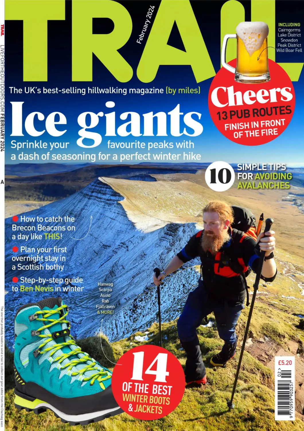
The UK’s best-selling hillwalking magazine (by miles) Cheers
a dash of seasoning for a perfect winter hike
bIMrLtTIr.
How to catch the
Brecon Beacons on
a day like THISt
Plan your first
overnight stay in
a Scottish bothy
Hanwag
Scarpa
Asolo
Rab
£5.20
Solace
One jacket to rule them all! The Solace is the first of its kind in
the Alpkit family. Our brand new insulated waterproof is made
with damp-proof synthetic insulation that keeps you warm when
it's cold, and dry when it's wet. Supremely versatile, the Solace
can be usedasa walking jacket, a ski jacket, or for instant warmth
after a winter swim or ride. It's got hand warmer pockets and
glove-friendly cuffs to accommodate ever-cooling extremities.
Made with 100% recycled lining, 70% recycled insulation and
a PFC-f ree DWR so it won't leak nasties into the environment.
A winter one-stop-shop layer.
£249.99
ttGONlCEPLACESDOGOODTHINGS
Y5 4 Ordnance
Ъай Subsets?
eQuw;Zpoc№t'.p^t3t
WELCOME TO TRAIL
Heading for Pen у Fan with the north face of
Com Du caught in shadow behind. In summer
this path is packed with walkers of all ages,
but in winter it's blissfully light on footfall.
L-TA-.<
TOM BAILEY
ROLL THE DICE
“If you spend too much time thinking about a
thing, you'll never get it done. ” We don’t quote
martial artists too often in Trail, but Bruce Lee
was definitely on to something when he spoke the
words above. I’ve spent far too much time gazing
at dark clouds and gloomy forecasts over the
years, then downgrading my plans to something
far less interesting as a result. But the simple
truth is that if you want to get out in the
mountains and experience something
epic at this time of year, you need to be
spontaneous. Just look at that photo
above, taken in the mountains of south
Wales on the kind of day the local climate
isn’t exactly famous for. Unless you live at the
base of them, it’s unlikely you can sit around
waiting for pristine conditions when it comes
to planning your next trip to the mountains.
So there has to be an element of rolling the dice
and taking a calculated gamble. You may end up
getting soaked to the bone, or spend a day relying
on your compass in the mist, or get stuck in
a Keswick cafe waiting for clear skies, or
maybe - just maybe - you’ll strike gold
like we did and find the Holy Grail of
winter hillwalking. It doesn’t happen
often, so make sure you’re there waiting
when it does. OH Reed, Trail editor
Cover photograph: On Pen у Fan with Cribyn behind by Tom Bailey.
EDITOR’S PICKS
Chris Lewis shares his
astonishing story of
setting off to walk
the UK coast alone,
and returning with
a young family p14
Ben Weeks lives the
adventure behind this
month’s cover image -
a day of days climbing
the highest peaks in
southern Britain p24
Phoebe Smith takes you on
a guided tour of two long-
distance trails - linking
the Norfolk Coast Path
with its near neighbour
the Peddars Way p 105
FEBRUARY 2024 TRAIL 3
Trail, H Bauer Publishing, Media House,
Lynch Wood. Peterborough, PE2 6EA
Phone01733462811
Email trailfabauermedia.co.uk
EDITORIAL
Editor Oli Reed
Deputy editor Jenna Maryniak
Art editor Louise Parker
Production editor Shane Collins
Gear editor Ben Weeks
Editorial assistant Sara Herbert-Mattick
Photographer Tom Bailey
ADVERTISING
Commercial manager Anna Skuse,
anna.skuseldbauermedia.co.uk
Classified sales Chloe Sharpe,
chloe.sharpeldbauermedia.co.uk
MARKETING
Marketing manager Zoe Blanchflower,
zoe.blanchflower20bauermedia.co.uk
Newsstand marketing Samantha Thompson
PRODUCTION
Print production Colin Robinson
Ad production leisureads0bauermedia.co.uk
Printers William Gibbons Distribution Frontline
SUBSCRIPTIONS & BACK ISSUES
To contact us about subscription orders, renewals,
missing issues, back issues or any other queries,
please email bauer0subscription.co.uk or phone
01858 438884 (UK) or +44 1858 438884 (overseas).
To manage your account online, please visit
secure.greatmagazines.co.uk/Solo
DIGITAL ISSUES
Email: digitalmagazinesupport0bauermedia.co.uk
H BAUER PUBLISHING
Managing director Steve Prentice
Digital managing director Charlie Calton-Watson
Chief financial officer Bauer Magazine Media
Lisa Hayden
CEO UK Publishing Chris Duncan
Where eagles dared
Riggindale no longer has its
resident golden eagle, but it’s
still a cracking day out in the
Lake District
Trail is published 13 times a year by H Bauer Publishing
No part of the magazine may be reproduced in any foim In whole or m part, without the prior
permission of H Bauer Publishing All material published remains the copyright ol
H Bauer Publishing and we reserve the right to copy or eon any material submitted to the
magazine without further consent. The submission ol material (manuscripts or images etc)
to H Bauer Publishing, whether unsolicited or requested. Is taken as permission to publish
that material in the magazine, on the associated website, any apps or social media pages
affiliated to the magazine, and any editions of the magazine published by гм licensees
elsewhere in the world
By submitting ary material to is you are confirming that the material is your own original
work or that you hare permission from the copyright owner to use the material and to
authorise H Bauer Publishing to use It as described in Itws paragraph. Tou also promise that
you have permission from anyone featured or referred to in the submined material to it being
used by H Bauer Publishing It H Bauer Publishing receives a claim horn a copyright owner or
a person featured In ary material you have sent us. we will mfomn that person that you have
granted us permission to use the relevant material and yov will be responsble for paying
any amounts due to the copyright owner or featured person and/or tor reimbursing H Bauer
Publishing for ary losses it has suffered as a result Please note, we accept no responsibility
for nnsollcted material which is lost or damaged in the post and we do mt promise that we
will be able to return ary material. Finaly. whilst we try to ensure accuracy ofywr material
when we publish it we cannot promise to do soi We do not accept any responsibility for any
loss or damage, however caused, resulting from use of the material
COMPLAMIS H Bauer Publishing is a member ol the Independent Press Standards
Organisation [wwv.ipso co.uk] and endeavours to respond to and resolve your concerns
quickly Our Editorial Complaints Policy (including full details of how to contact us about
editorial complaints and IPSO's contact details] can be found at
w*w bauermediacomptaints.co u*
SYNDICATION DEPARTMENT syndication emefecauk
H Bauer Publishing is a company registered in England and Wales with company number
LP003328. registered address Media House. Peterborough Business Park. Lynch Wood.
Peterborough. PE26EA.VAT no 918 5617 01
H Bauer Publishlog Is authorised and regulated by the EGA (Ref Na 8081
©Bauer 2023
6 Peak of the Month
Cuillin monster Sgurr Alasdair
8 Base Camp
Happenings from high places
10 Whisky Peaks
Take a tour at the Clachaig
20 Out There
22
58
Your stories from the hills
Nature Notes
Winter’s night skies
Mountain skills
Top advice from
Trail's experts
FEATURES
24
Mountains
for the Mind
The amazing story of
one man’s six-year walk
around the UK’s coastline
Pen у Fan
Meet the north face of the
Brecon giant
Chris Lewis went for a
Mountain
Challenge
Time for a
New Year
challenge?
We’ve got
the best
suggestions
for 2024!
4 TRAIL FEBRUARY 2024
On High Street
looking down the
Riggindale valley,
framed by its grand
ridgeline descent to
13
MOUNTAIN ROUTES
IN ASSOCIATION WITH
Ordnance
VJ survey
83 Wild Boar Fell, Cumbria
85 Ben Klibreck, Northern Highlands
87 Place Fell, Lake District
89 Yr Wydffa (Snowdon), Eryri
91 Ben Vrackie, Highlands
93 Offa’s Dyke, Brecon Beacons
Crossing Scar Crags
on Causey Pike’s
ridge - p101.
GEAR
66
76
71
72
LONG-DISTANCE TRAILS
105 PeddersWay&
Norfolk Coast Path
THREE PEAKS IN WINTER
110 Ben Nevis, Highlands
Mountain-tested:
Coats for winter
warmth.
ULTIMATE WEEKENDS
95 The Limestone Way, Peak District
99 Whinlatter Pass, Lake District
Field Test
Insulated jackets
Microspikes & crampons
Head to Head
Winter boots
Long-term tests
FEBRUARY 2024 TRAIL 5
BASECAM
YOUR ADVENTURE STARTS HERE
ISLE OF SKYE
PEAK
OF THE
MONTH
Sgurr Alasdair
At 992m, Sgurr Alasdair is the highest peak on the most
mountainous of Scotland’s islands. And as a result, is
sought by everybody. There are many highlights on Skye’s
famed Black Cuillin ridge, most of which can’t even be
considered without the use of rope and harness. And
although you could never truthfully describe the most
popular route up Sgurr Alasdair via Coire Lagan and the
Great Stone Chute as a ‘walk’, it is possible to achieve
with a gutsy mixture of mountain fitness, reliable foot
placement, and an ability to stay calm when the drops
start opening up. The short and sharp ridge to the summit
(below) is typical Cuillin terrain, in the sense that you’ll
feel very much as though the mountain doesn’t want
you to be there - like a boat in stormy waters, trying
everything to flip you overboard. But when you do reach
its compact pinnacle, the sense of achievement is as
big as the views; which stretch across sea, island, loch
and crag all the way to Ben Nevis (50 miles south-east).
Alexander’s Peak’ makes a fine day route in winter, but is
even better as part of a full ridge traverse ( ?4 ).
TOM HODGSON
Picks
Places we’ve been,
l things we’ve seen, and
mountain-related £
stuff we like
CAMPSITES
OF THE YEAR
VIEW WITH A PUB
YHA EDALE,
PEAK DISTRICT
If you’re feeling the need to get away from
it all after the Christmas frenzy, a weekend
in the Peak District might be just what
you need. And if you’re feeling the pinch,
YHA Edale has rooms this winter starting
from an amazingly budget-friendly £12 for
a single private room! There's a licensed
bar, breakfast and a self-catering kitchen.
But best of all is the location - perched on
the slopes of Kinder Scout and looking out
to the Great Ridge of Mam Tor, it’s hard to
imagine a better base for walkers. And at
just 2.5km from Edale train station, you
can ditch the car too. Availability is limited
to weekends over the winter, but check out
the website for the best deals in the YHA
January sale, yha.org.uk
OUR TRAILS ARE IN A STATE
Campaign group Trash Free Trails has collated data collected between 2020
and 2023 in its The State of Our Trails Report, with some shocking results:
The AA has just
announced The
Hats off!
4500+
people have helped
remove 216,466
items of single-
use pollution from
5000km of trails.
9,000,000
items of litter
are estimated to
pollute the UK’s
rights of way.
14,000,000,000
plastic drinks bottles are used in
the UK every year. Yet less than
50% of them are recycled. Find
out more about the campaign for
Deposit Return Schemes (DRS) at
trashfreetrails.org
Quiet Site, near
Ullswater in the
Lake District, as
its Campsite of the
Year. Also a firm
Trail favourite, the
AA inspector said:
"At this wonderful
park guests can
For a limited time Go Outdoors is giving
100% of profits from its range of celeb-
designed hats and flasks to mental health
charity Mind. Ambassador Julia Bradbury
said: “We have all faced some kind of
difficulty or challenges in life, so I’m
delighted to be part of
impressive is owner
Daniel Holder’s
GOING LOCAL
Known for his
microadventures, Alastair
Humphreys’ new book, Local,
reflects on his year exploring
the map area around his own home. He discovers
that nature and wildness are closer than we
think. It is an ode to slowing down and the
meaningful experience of truly getting to know
your neighbourhood. It is also a celebration of
time spent outdoors, and a rallying cry to protect
the wild places on our doorstep, alastairhumphreys.com
READ
THIS
sufficient.” Book
enjoy the stunning
views of the lake
and surrounding
fells. Equally
commendable
ethos on
sustainability,
and for achieving
such exemplary
standards in
developing one
of the greenest
parks in the
country the park
is now 90% self-
your stay at:
thequietsite.
co.uk
Hats On For Mind,
highlighting the
positive impact
the outdoors has
on our wellbeing.
Sometimes the
easiest way to
open up to a
friend or loved
one about
how you feel
is by taking a
long walk and
simply talking
side by side.
This has helped
me so many
j times, and I hope
is something that
can help others
too.”
gooutdoors.
co.uk/bnmind/
DAVID VENNI
8 TRAIL FEBRUARY 2024
TIKKA® CORE & ACTIK® CORE
The new TIKKA® CORE & ACTIK® CORE are compact, powerful and easy to
use with lighting suited to a variety of outdoor activities. With a simple single
button both headlamps also have red lighting and come with the CORE
rechargeable battery, petzl.com
Access
the
inaccessible®
BASE CAMP
WHISKY PEAKS
OF THE
CLACHAIGJNN
n a not entirely unusual turn of
events, it’s hammering it down in
Glen Coe. The sort of rain that’s
bouncing so hard off the tarmac
that as much seems to be coming
up as is coming down. It’s windy
too. Every so often a strong gust will
catch the drops and whisk them off
their downward or upward trajectory
and hurl them sideways instead.
It’s been doing it all day, so
walking in the hills has been off the
cards since breakfast. Instead, we’ve
explored the gear and gift shops of Fort
William high street, restocked supplies from
Ballachulish Co-op and, having walked the
gauntlet of pinball raindrops along the lane from
Failed at the last nip!
the Red Squirrel campsite to the Clachaig
Inn, are currently huddled in the Boots
\Bar, waterproofs steaming by the fire.
We have a plan though. The
summits may be out of bounds, but the
mountains permeate every aspect of
I life in these parts. The Clachaig Inn is
I a mountaineers’ pub, with ice axes for
Я door handles, hills filling every window
Ж and picture frame, and a staggering
JF range of whiskies behind the bar - many
j? of which bear the names of mountains.
What better way to indulge our orophilia*
while remaining warm, dry and comfortable
than working our way through a round or
four of the Clachaig’s magnificent collection?
It may be a tough task, but we’re up to it...
’OROPHILIA; A LOVE OF. OR AFFINITY TO, MOUNTAINS.
ROUND 1
ROUND 2
ROUND 3
ROUND 4
Ben Nevis 10 £10.45
MOUNTAIN REFERENCE:
Ben Nevis. Obviously.
THE CLACHAIG SAYS:
"Full-bodied with a whiff of peat,
lots of tropical fruit, and hints of
coffee and dark chocolate.”
WE SAY: "I can't help but feel
that this sells more based on its
name than its taste.”
RoyalLochnagar12
£4.50
Mountain reference:
Lochnagar
THE CLACHAIG SAYS:
"Planed wood, light toffee.
Linseed oil behind, and later a
lychee-like acidity”
WE SAY: "Ooh, I like this. Not
as fiery as some but loads of
flavour. Nice!
Jura 19 The Paps
£11.95
Mountain reference:
The Paps of Jura, perhaps?
THE CLACHAIG SAYS:
"Subtle green apple sharpness,
swiftly balanced by layers of
thick caramel and chocolate
chip cookie dough.”
WE SAY: "Probably a perfectly
pleasant dram but compared to
the Royal Lochnagar it's lacking
something."
ROUND WINNER:
Royal
Lochnagar12
Benriach
10 Curiositas £4
MOUNTAIN REFERENCE:
There are loads of mountains
called Ben, aren’t there?
THE CLACHAIG SAYS:
"At once sweet and heavily
smoked. Peppery spice tingles,
iodine, a warm nuttiness.”
WE SAY: "It’s not an actual
mountain? Sounds like one.
Doesn’t matter - I love the
peaty goodness of this.”
Benromach 30 £20
MOUNTAIN REFERENCE:
The Romach Hills
THE CLACHAIG SAYS:
"Rich Christmas cake covered
in marzipan and icing with a
sprinkling of winter spice on top!”
WE SAY: "Amazing. All the
taste without the wasabi burning
sensation. Should come with a
free haggis at this price though.”
Benrinnes 15 £6.50
MOUNTAIN REFERENCE:
Ben Rinnes, naturally.
THE CLACHAIG SAYS:
"Rounded, good sweetness.
A whiff of peat.”
WE SAY: "Really rather
pleasant. Quite a sweet whisky,
but a hint of smoke that makes
a good introduction to more
peaty options.”
ROUND WINNER:
Benromach 30
Tomatin 14 £6.50
MOUNTAIN REFERENCE:
Maybe Tomtain in the Kilsyth
Hills? Although it is spelled
differently. And is 130 miles
away from the distillery.
THE CLACHAIG SAYS:
"Sweet and honeyed at first, with
an oaky edge. A bite of citrus and
a hint of dark chocolate.”
WE SAY: "For such detailed
tasting notes, this has a lot of
punch and not so much flavour.
But I might have pickled my
taste buds.”
Tomintoul Hath £3.60
MOUNTAIN REFERENCE:
Tomintoul village (meaning
’Hillock of the Barn’)
THE CLACHAIG SAYS:
"Light and creamy. Lively white
pepper and some oak-driven
spiciness dance on the tongue."
WE SAY: "For a cheap’
whisky this is rather nice. Very
drinkable. Dangerously so.”
Tormore13£4
MOUNTAIN REFERENCE:
Tor - a high craggy hill
THE CLACHAIG SAYS:
"Zesty fruitiness of orange
peel and lemon sherbet, with
a smooth creamy vanilla
sweetness.”
WE SAY: "I’ve got to be
honest - I’ve finished the glass
and already forgotten what it
tasted like.”
ROUND WINNER:
Tomintoul Hath
The Arran Malt Port
Cask £3.50
MOUNTAIN REFERENCE:
There are loads of mountains on
the Isle Of Arran, aren’t there?
THE CLACHAIG SAYS:
"Layered fruits and spice
combine, with cinnamon baked
apple wrestling with raisin and
plum pudding.”
WE SAY: "Tastes like
Christmas with a kick. Probably
the cause of Rudolf’s nasal hue.”
Aberlour 10 £4
MOUNTAIN REFERENCE:
There isn't one, but Aberlour
village is where Walkers
Shortbread is made. Yeah,
we’re stretching now.
THE CLACHAIG SAYS:
"Spicy rich fruitcake, toffee notes
and a creamy malty feel.”
WE SAY: “The name sounds
like a fart in a bath. Nice though.
The whisky, not the fart."
Peat Reekers£3.60
MOUNTAIN REFERENCE:
The mountains are full of peat...
THE CLACHAIG SAYS:
"Fresh wood shavings and dried
apricots. Salty peat smoke,
vanilla, milk chocolate. Spicy,
smoky and warming with a
creamy mouth-feel.”
WE SAY: "What the hell did
they do to this? I think my tonsils
have grown back."
ROUND WINNER:
Aberlour 10
FEBRUARY 2024 TRAIL 11
TRAIL 100
“The world turns golden -
the treasure has been found"
WILD SLEEPS
THIS MONTH
Askival
Cross Fell
The Cheviot
Ben More
Ben Alder
TRAIL 100
BIVVY COUNT
70/100
RUSS MOORHOUSE is on a mission to camp out on every Trail 100
peak - a challenge that spans four countries, 100 of the UK’s
finest hills and mountains, and a punishing 88,339m of ascent.
This month Russ suffers the curse of the British weather (again),
but he still strikes gold in the end...
w
e must accept finite disappointment,
but never lose infinite hope. No matter
how many times I go camping it is the
hope for a golden sunset, a Brocken
spectre, magnificent cloud inversion
or to witness one of the other magical wonders you
only see from the top of a mountain that gets me
motivated. But it doesn’t always turn out that way.
Plenty of bog and fog
I start this month in a place I’ve never been before,
The Cheviots. It’s a lovely change for a secluded
camp on a hazy day, with rolling hills, views of the
North Sea and plenty of bog. The summit trig keeps
sinking, so every few years they have to dig it out
and add a new base, and it now resembles a three-
tier wedding cake. The promised sunset doesn’t
arrive, but I’ll keep hoping.
“Kids, we are going on holiday!” Of course
amongst playing on the beaches, exploring the
island and jumping off the pier into the sea, there is
a mountain. And what a mountain. You have
to pass through the gates of hell (well,
climb Hallival) to get there. Askival
on the Isle of Rum is then reached
by a long knife-edge ridge.
Unfortunately (or perhaps not)
we are in cloud, so don’t get
to see the deathly drops.
One family camp is enough
for them this month, so on
Cross Fell they come for the
walk and then leave me to
camp. Tea in Greg’s Hut is
welcome despite the detour,
and I enjoy another quiet if
cloudy hazy evening on the large
summit plateau in my bivvy bag.
Finding the gold
Glorious tangerine sunsets or sunrises are what I
enjoy on the mountain tops, but I’m not having
much luck so far. Ben More in Scotland, a mountain
I’d previously saved for later in this adventure due
to exhaustion, is in no better shape today. Savagely
steep the views are patchy at best and I wish I
had already done this one. Then the rain rolls in,
extinguishing all hope for today.
‘Solvitur ambulando’ is St. Augustine’s quote,
which means ‘there is nothing that can’t be solved by
a good walk’, rings true on Ben Alder. It is certainly
a good and very long walk to reach even the base
of this mountain, never mind the summit. But here
on the summit hope is restored as the world turns
golden, a metallic sunset, no rainbow of colours,
only pure gold - the ground, my tent, the sky, it’s all
gold. The treasure has been found. D
Follow Russand his ’Trailof 100 Nights’ adventure on
Instagram Oamountainbivvy
WHAT ISTHE TRAIL 100?
The Trail 100 is our definitive collection of the 100
UK peaks every hillwalker should climb in their
lifetime. Start your challenge at lfto.com/trail100
OFFICIAL PARTNERS
0 SCARPA
О komoot
//Lowe
Valpine
12 TRAIL FEBRUARY 2024
Russ's first time in the rolling
hills of The Cheviots.
MOUNTAINS FOR THE MIND
Living wild for six years,
Chris endured every kind of
weather and terrain that the
UK could throw at him.
14 TRAIL FEBRUARY 2024
MOUNTAINS
CIMINO
LIVING ON
THE EDGE
People often set off on life-changing journeys. But they’re rarely
as obviously transformative as Christian Lewis's six-year,
19,000-mile walk around the entire UK coast.
WORDS SARAH RYAN
think my biggest ally, ironically, was my state
•• of mental health,” says Christian Lewis. “I was
just so desperate to get away. I wasn’t running
away from my problems. Definitely not. It was
more like trying to take a telephone call in a
concert - you need to step away to understand
what’s going on. ”
On 29 July 2023, Chris left jlhossilli on the
Gower Peninsula and walked a mile up the
coast to Llangennith beach, with the sea on his
left. Six years earlier, he had walked towards
that same beach terribly hungover, coming
down from a speed-spiked-coffee, not even sure
if he was going to turn left or right when he got
there. He had decided only a few days before to
walk the UK coastline. Much more detail than
that, including whifch direction he’d go, would
be worked out as he went.
Six years and about 19,000 miles later -
there is no exact mileage of the UK coastline,
changing as it does with the rise and fall of
the tides and the unceasing grind and deposit
of erosion - he returned to the same spot, this
time with partner Kate, dog Jet, baby Magnus
and a head addled only by elation.
Setting off
In July 2017, three days before setting off
on his then incomprehensible journey, Chris
had walkeW down to a turbulent sea with his
surfboard. The waves were too overwhelming,
too powerful, to paddle into, so he walked out
to a cliff and jumped in behind them instead.
Standing on the ledge, looking down at the
heaving sea, he understood that such an act
could kill him. He also understood that he
didn’t want to die - but he didn’t much want to
continue struggling on like he was either.
Then 37, a single parent and former
paratrooper, Chris struggled to make the
transition to civilian life. For years he moved
from one shdlt-term job to the next, doing stints
as a bouncer, labourer, private investigator and
earning some extra money in the boxing ring.
FEBRUARY 2024 TRAIL 15
MOUNTAINS FOR THE MIND
QUICK-FIRE
^QUESTIONS
Most indispensable
bit of kit?
"My knife. You can use
it to make clothes,
chop kindling, forage
food, build a shelter...
I forged a knife in fire
in Orkney, and kept it
on me all the time."
How many boots did
you get through?
"No idea! I went
through loads at the
start as the majority
were hand-me-downs
that were pretty much
on their way out
anyway. It was only in
the Outer Hebrides
that I got my first ever
decent pair of boots and
they lasted me until
Shetland, so - a lot!"
Best meal?
“I remember walking
through Shetland over
Christmas and New
Year. It was brutally
cold and hailing, and
I could smell all the
roast dinners being
cooked but all I had was
tuna and beans. About
five days later, when I'd
finished Shetland, I got
invited to a roast with
meat, potatoes, veg,
everything buttered.
Hl’d been thinking about
it for so long, it was
probably my most
enjoyable meal ever."
Most beautiful
place in the UK?
“The Scottish islands.
Scotland has the right
to roam, so the freedom
is amazing. And the
islands are out of this
world. Some of them,
it's like you're in the
Bahamas. But the
beauty of it is it's just
so quiet. It's very, very
magical. And the people
are so laid-back."
Still, Chris struggled to maintain the costs of
a secure home. He spiralled into depression,
wracked with overwhelming anxiety. When his
daughter, aged 16, decided to leave their flat in
Swansea, he was only a few weeks from eviction.
Three days later he left too, in boots that were too
big for him, with a holey tent and £10 in
his pocket.
“I had faith that somehow I’d make it work,”
he says. “It’s not the way most people do things
- winging it and taking things day by day - and
I think that was a major part of why I got so
down in the first place. I didn’t feel like I fit into
society in that respect. But when I set out on this
adventure, it happened that living day-by-day was
the only way to do it.”
Change
“Once the feeling that I was a homeless guy
walking the coast dispersed and I started realising
that I was good at what I was doing - getting
better at fires, at foraging, and getting my
equipment down to an absolute T - that’s when
my relationship with myself changed,” he says.
“I started to focus on what was ahead rather than
what was behind.”
After a year, he had walked north along the
coast of Wales, climbed Yr Wyddfa (Snowdon),
trekked through the Lake District, walked the
coast of Northern Ireland and caught the ferry
back to continue up to Mull. It would be easier
to shortcut the process, interpreting the coastline
as that of the mainland, but he walked the
16 TRAIL FEBRUARY 2024
Jet, a greyhound-saluki
cross, came into Chris’s life
in 2018 when he was being
given up fbr adoption on the
west coast of Scotland, and
became his loyal companion
for the rest of the journey.
"I EXPERIENCED THE
KINDNESS OF PEOPLE
AND I REALISED
THERE’S SO MUCH
MORE GOQD.GOING ON,'
PROBABLY. THAN BAD”
Incredibly Chris met fiancee Kate along the way, and they now have baby Magnus.
circumference of the major (and some smaller) islands of the
Hebrides too.
“It became a bit of an obsession. I just wanted to get better
and better at it. My hearing became better, I felt healthier, I
felt driven, I had a purpose,” he says. “Once I knew that was
happening I felt like there was no stopping me.”
Along the way, he forced himself to engage with people in
order to raise funds for the SSAFA, an armed forces charity.
Rarely did he ask for anything for himself, yet he received
numerous gifts, from a new tent, boots and stove, to several
much-needed hot home-cooked meals.
“I used to spend a lot of my time watching politics and
it would make me angry,” he says. “I’d lost my faith in
humanity. But when I got out there, I experienced the kindness
of people and I realised there’s so much more good going on, _
probably, than bad.”
Chris* diet has improved since his early foraging days.
‘ Limpets, mussels, whelks... I never want to see one again!” he says.
CHRIS LEWIS
Find out how you can join our 18,000-strong
community and support the cause at
mountainsforthemind.co.uk
FEBRUARY 2024 TRAIL 17
| MOUNTAINS FOR THE MIND
Challenge
Chris started the walk with the scantest possible
plan - to walk the UK coastline was the beginning
and the end of it. He had no restrictions on time,
no deadlines by which he needed to be home
and no ‘home’ to go back to even if he did, so he
allowed the walk to simply take the time it took.
“I didn’t take the approach of planning to
walk, say 20 miles, every day,” he says. “Along
the coast you can come across a boulder field or
a huge ravine that takes hours to cross, through
ankle-breaking stuff and at the end you’ve only
done three miles. So I slipped away from that
approach very, very quickly. ”
As well as being impractical, this approach, he
believes, would have been too taxing on body and
mind. At the start of the walk, he would go for
several days on little to no food, walking for miles
on the sustenance of a plate of toast and beans or a
bowl of rice. Looking in the mirror at one stop on
the journey, a gaunt image reflected back at him.
“I knew after about a year that the most
important thing to do, to make it stress-free, was to
listen to my body,” he says now. “If you know, in
the back of your mind, that you’ll be going home
soon, where you can get a bath or a shower, put
your feet up and cook a nice meal, you can push it
more. When you don’t, you have to take it slow. If I
had put any kind of pressure on myself, then I may
as well have gone back to live in Swansea.”
In order to support this way of living and
walking, and with very little money, Chris learned
to forage, gathering shellfish and seaweed that
he’d cook over a fire at the end of the day. It’s
the kind of thing that has launched a thousand
fantasies on Instagram but the reality for Chris
was quite different. “I hate shellfish, so I was
foraging out of necessity,” he says. “Limpets,
mussels, whelks... I never want to see one again!”
The journey took him through some of the most
challenging terrain in the UK, as where paths or
GIVING
BACK
In order to give
back for the support
offered to him in
the years before the
walk, Chris started
fundraising for the
SSAFA. The initial
goal was £1000, and
at time of writing
the donation page
stands at £395,275
and is still open:
justgiving.com/
fundraising/
chriswalks
Chris has written two
books about his amazing
experiences. Finding Hildasay
is a Sunday Times’ bestseller,
and Hildasay to Home is
due to be released on 28
March 2024 and is currently
available for pre-order.
roads didn’t closely follow the coast he eschewed
them to follow the actual coastline, ploughing
through bog, bramble, traversing ground
sloping steeply into the sea and sloshing through
innumerable fast-running burns.
“My favourite parts of the walk were the places
where there were no trails,” he recalls. “On a lot of
the west of Scotland - from maybe Oban upwards
- there aren’t any anyway. I loved the challenge of
working out how the hell to get around something
that looked completely impossible.”
When asked about the biggest challenge though,
it was not related to the ground at all. “Terrain is
terrain,” he responds, “The biggest challenge was
always the weather. You can fall over and break a
leg on a hot sunny day and you’re okay, but lose
your tent in a storm in the middle of nowhere
and you can die of hypothermia very quickly. I
practised putting my tent up even in bad winds,
just for the safety net of it.”
Home?
Along the way, he met his now partner Kate and
in May 2022 the pair welcomed baby Magnus,
who accompanied them on the last stages of
the walk, tucked into a child carrier backpack.
Chris also wrote his first book, Finding Hildasay,
scribbling it out on an A4 pad that he carried with
him as he walked, and has spent the three months
after finishing the walk writing a second. The
plan for what comes next is still loose - just more
walking, more adventure - but that for him is part
of what’s been won: the ability to live on his own
terms, day-by-day.
“I could have stopped at any time but the
important thing for me was to wake up in the
morning with real purpose,” he says. “I hate it
when people say ‘make sure you’ve got a back-up
plan.’ It’s something I’ll never teach Magnus. For
me, that’s already setting yourself up for failure.
But more importantly, you’re wasting time doing
something else just in case you don’t do the thing
that you love.”
Near the start of the journey, someone warned
him about the roughness of the ground he’d be
walking when he reached Scotland in winter,
recommending that he plan ahead and perhaps
seek sponsorship. Chris welcomed the care
behind the advice but turned it down. That way
of thinking, he said, had always failed him in
the past. “The amount of people who would say
something like, ‘Oh my God, this next part is
dangerous, I only know one person who’s ever
attempted it!’. I don’t listen to that,” he says.
“Because people only ever give you advice based
on what they think they’re capable of doing.”
He didn’t know what he was capable of at
the start but it now includes walking the coast,
writing two books, and growing a family. “It was
the first time in my life that I listened to myself
and not other people,” he says, “and look what
happened.” Q
ADRIAN WHITE FOR SSAFA
18 TRAIL FEBRUARY 2024
Proud and emotional scenes as
supporters join Chris and Kate on
their final mile along Llangennith
beach on the Gower Peninsula.
SUPPORTED BY OUR OFFICIAL PARTNERS
Ordnance
Survey
ellisbrighaml
MOUNTAIN
SPORTS
FBMC a" ter Ж Ж
FEBRUARY 2024 TRAIL 19
there
YOUR MOUNTAIN SNAPS
& TALES FROM
THE TRAILS
Beinna’
Chrulaiste
West Highlands
"Our dog Kai loves the
hills - they’re his big
playground. When he sees
the tent or the climbing bag
being packed he knows he
is off for an adventure. He
certainly isn’t an indoors
dog, and we couldn’t
imagine being on the hills
without him.” Brian Welsh
Blencathra Lake District
io Wail February^
"Here’s a photo from a chilly sunrise
hike up to Blencathra, when I caught
the gorgeous morning colours over
Sharp Edge." Hannah Blundell
Thorang La Nepal
"After many years of trudging the Scottish hills,
I realised a lifetime ambition of trekking in the
Himalayas. A retirement present to myself, I took
my son Torin on the Annapurna circuit tour. We
had a great team from Intrepid tours, and after a
4am start managed the Thorang La pass at 5416m.
Fantastic weather and scenery.” Robbie McFedries
Cnicht Snowdonia (Eryri)
"This is our 3-year-old border collie Gwyn
enjoying her best life. She has had many
mountain adventures and one of our
favourites is here on top of Cnicht for its
beauty and solitude.” Clare and Ian Dallaway
Ben More Isle of Mull
"Lewis and Harriet at the summit of Ben
More, on the Isle of Mull. This is their
second Munro at the age of 6”.
James Edwards
SEND
US YOUR
BEST PIC
Every month the best pic will win a Multimat
mattress worth £135! The Summit 25/38
is tough, light, durable and maximises
comfort in the most extreme conditions,
multimat
ba comfortable sleep uuarm
SEND YOUR PHOTOS TO ‘OUT THERE’: traiirabauermedia.co.uk
FOLLOW TRAIL: @ ratrailmagazine D
facebook.com/trailmagazine (Ё)
ratrailmagazine
FEBRUARY 2024 TRAIL 21
NATURE NOTES
Cold nights, cosmic lights: The
wonder of winter night skies
WORDS TOM BAILEY
I have an obscure interest in the literature
of WWI. One of my favourite authors, a
chap called Max Ploughman, a serving
officer, then a committed pacifist, once said
this simple truth: “You cannot shoot the
stars”. This I’ve always taken to mean that
they are the one thing we can’t mess up - ie
the stuff that’s too far away. With that thought
in mind, this month’s theme is the winter
night sky, as winter is the best time to see a
spectacular display of stars at their brightest.
Firstly, you won’t read here about the
moon or the Northern Lights, as I’ve already
covered them in previous articles. So stars -
what are they? Good question, not sure the
answer is really going to help, but here goes...
A star is a luminous (shiny) spheroid (ball) of
plasma (stuff), held together by self-gravity
(some kind of glue!?).
What’s a constellation? Glad you asked,
because it is quite simply a group of the
aforementioned stars that are visible with the
naked eye and form a recognisable pattern
or shape, on which an identity can easily
be attributed. There are, in fact, 88 official
constellations in Earth’s night sky.
Probably the most useful star to find is
Polaris, or the North Star. For us walkers,
and indeed any travellers, having a mark
right on north is always going to be a massive
navigational aid, providing the skies are clear.
Because it sits almost directly over the North
Pole, it doesn’t move like the other stars
appear to (obviously they’re not moving, but
the Earth is spinning).
To find Polaris, you need to know what the
Plough looks like and roughly where it’ll be
in the sky. As every good Cub Scout knows,
the Plough is actually more the shape of a
saucepan, four stars making up the pan and
three the handle. Search the sky left of where
the sun set, link up the two outer stars of
the pan and project a line upwards, and you
get to Polaris. It’s very easy to find once you
know how.
The Plough isn’t technically a constellation,
but an asterism. However, the Plough is part
of a constellation, that being Ursa Major,
or the Great Bear, with the Plough being
the lower half of the body. The Plough is a
great starting point from which to find other
constellations, such as Cassiopeia, Gemini,
Cancer and Leo. The Plough is visible in the
night sky all night long, 365 days a year.
Another easily identifiable constellation
that’ll form the basis for finding others is
Orion, otherwise known as the Hunter. It can
be found towards the south. Orion is only
visible during the winter months. Orion’s
belt is a line of three stars that obviously
make the belt of the hunter, but if you draw
an imaginary line through it, it’ll lead you to
Sir us on one side and Aldebaran on the other.
It’s a kind of signpost to the stars. Two of the
brightest stars in the night sky contribute to
Orion’s shape. The first, Betelgeuse, forms
a shoulder of the figure. It’s the star in the
galaxy that’s next in line to go supernova.
Basically, it’s really old and technically known
as a red supergiant. The brightest star in
Orion and the sixth brightest in the night sky
is Rigel, a blue supergiant.
WINTER IS THE BEST TIME TO
SEE A SPECTACULAR DISPLAY OF
STARS AT THEIR BRIGHTEST ___________________I
Of the planets (and remember the best
way to tell a planet from a star is that they
don’t twinkle), Jupiter is the most obliging
in the winter sky, being visible most of that
time. Jupiter is both the largest and the oldest
planet in our solar system. It’s easy to see, and
if your eyes arc good you’ll even be able to
make out its shape. With the aid of binoculars
it's possible to see at least two of Jupiter’s
moons. This kind of thing always blows my
mind. 1 think if I ever got one of those big
telescopes I'd become nocturnal and obsessed /•’ . ,;*j
with the stars, l ike the mountains, they leave
me in awe at our insignificance in the world.
Xc\t rimc 4nllIV limping in rhe hills and
gel llP Гиг 1 wcc- P “ ’P lJP ‘^rcr volJ
lot iking d< >\\ n, because \ < >u i nigh I ]tisi be ИР?
m one of the best places in Britain to fully •*
appreciate the winter night sk\ . И v ~
Tom Bailey is an outdoor writer, nature expert
and long-serving Trail magazine photographer.
STEVE HALL
22 TRAIL FEBRUARY 2024
THE WORLD’S
WARMEST BASELAYER
Designed in Japan, made for the outdoor world, Zerofit unisex baselayers are game-changing products for walkers and hikers who
refuse to let colder temperatures stop them from enjoying the hills, mountains, lakes or forests.
Created by a passionate team of innovators and baselayer specialists, the Zerofit Heatrub Ultimate is the most technically
advanced baselayer on the planet and completely different to any other product you’ve ever worn before.
WHAT MAKES IT SO GOOD?
1. It’s five times warmer than a
standard baselayer
That is quite a claim, but it’s a fact. Tested at the
iconic Boken Institute in Osaka, the Heatrub
Ultimate baselayer recorded a Heat Retention
Rating of 0.78; a standard baselayer would have
a rating of between 0.1 to 0.14. And for reference,
a jumper would typically have a rating of 0.3. The
Ultimate performs best in a temperature range
of-10° Celsius thru 10° Celsius - so even in the
coldest of conditions, it has got your back.
2. Instant warmth the moment
you put it on
A standard baselayer traps body heat between
your skin and the material, so it takes a little time
before you feel the benefits. With Zerofit, five
separate fabrics, along with a patented knitting
process, create instant warmth as soon as you
pull it on. We don’t engineer our products with
compression for heat as a technology, unlike
other brands. The unique fabric mix means you
don’t need the tightness in order for it to work,
making it super comfortable too.
No need for
multiple
additional
layers-a game-
changer
Heating
from top
to toe
3. Fewer layers, greater warmth
and freedom to move
The Ultimate is the ideal product for people
who dislike traditional tight baselayers. Over the
years, you may well have ‘layered up’ in order to
combat the effects of cold weather. This is
where we are changing the game. The Heatrub
Ultimate is so good at keeping you warm, you
won’t need multiple additional layers, giving
you greater freedom to move easily. In short,
fewer layers yet greater warmth.
Five times
warmer than
astandard
baselayer
4. Central Heating from
top to toe
Innovative ‘Heat Threads’ positioned on the
inside of the garment gently rub against your
skin as you move, which creates positive
warmth across your body and this instant heat
is retained while you’re wearing the baselayer.
We also produce Heatrub Ultimate Leggings
and Heatrub Ultimate Socks that are made
from the same material and work in exactly
the same way, so you can have top-to-toe
warmth with Zerofit.
ZEROFIT HEATRUB MOVE - ADAPTABLE WARMTH ON THE GO
Instant heat
the moment
you put it on
ilot
The Ultimate baselayer is perfect for the coldest of conditions,
but it is complemented by the Heatrub Move (£40), which is
twice as warm as a standard baselayer and ideal for milder
temperatures of between -5° thru 12° Celsius. It features a 45%
polypropylene construction on the inside of the baselayer and a
hollow polyester shell that combine for ‘Adaptable Warmth’,
keeping you cosy when you’re at a standstill yet regulating
temperature and ensuring you don’t overheat as you move. The
construction removes sweat from the skin and evaporates it off
the surface of the baselayer quickly, so that nasty feeling of ‘cold
sweat’ never materialises.
Zerofit Heatrub Ultimate baselayer (available in Black, White, Grey, Green, Navy and Red) - £55 Zerofit Heatrub Ultimate leggings (available in Black) - £55
Zerofit Heatrub Ultimate socks (available in Black) - £25 Zerofit Heatrub Move baselayer (available in black, white and titanium) - £40
FOLLOW US! f @Zerof itUKIRE © Instagram: @zerof iteurope FOR MORE DETAILS, PLEASE CONTACT inf o@zerofrtxo.uk
SEE THE FULL RANGE AT WWW.ZER0FITX0.UK
BRECON BEACONS
The head of Cwm Sere, with the
striated horizontal patterning of
Cribyn and Pen у Fan’s north faces
highlighted by the dusting of snow.
BRECON BEACONS
My wife loves MasterChef. Regular MasterChef,
MasterChef: The Professionals, Celebrity MasterChef
- she’ll watch them all. Personally, I’m not a fan. I
get no great enjoyment from watching people create
amazing food I can’t eat; it just makes me hungry.
But if there are two things I’ve picked up from the
constant criticisms of the presenters, it’s that a biscuit
base is best when buttery, and that seasoning is
everything.
In that respect, Pen у Fan has a lot in common with a pan-fired sea bass. It’s a
reliably tasty mountain, and one that’s unlikely to disappoint. But if you want a truly
exceptional experience, it needs some seasoning. Naturally we’re not talking about
a twist of ground pepper, a dash of paprika, or a dollop of ketchup (note to Gregg
Wallace: when does seasoning become a condiment?). With mountains, we mean
snow. Whether that’s a Salt Bae sprinkling, or a thorough Nigella basting of the stuff,
snow adds a whole new dimension to even the most familiar of mountains.
Pen у Fan is a prime example. Thousands
upon thousands of boots march to its
summit every year, but the vast majority of
those will avoid the snow. And while we’re
generalising ascents of the Brecon Beacon’s
headline peak, it’s also fair to say that
those same boots will mostly be marching
up the paths that climb gently from the
conveniently placed parking areas on the
A470. So, a dusting of snow adds an extra
dimension to the mountain, but so too does
an alternative approach.
Now, Pen у Fan is a splendid mountain,
but to describe it as Alpine is perhaps a
stretch. However, there is one particular
feature that Pen у Fan shares with many of
the most famous Alpine peaks, and that is
a stonking north face. Like the Eiger or the
Matterhorn, the north face of Pen у Fan is
steep and sheer, dropping from the summit
into the valley bellow through contours so
closely spaced that their lines are barely
discernible on the map.
So, let’s think about this (and you can
probably hear the cogs turning); if we were
to tackle Pen у Fan from the north, via
its steepest aspect, when the mountain is
wearing a coat of snow, could we accurately
describe that as an ‘alpine ascent’ of the
summit? ‘Accurately’, probably not. But if
we allow a little imagination and the kind
of childish dedication to adventure that are
so often the ingredients of the best days in
the hills, then we might have something
going here.
There are several well-established
routes that lead to the top of Pen у Fan
from the north. The most direct climbs
the mountain’s northern spur, Cefn Cwm
Llwch, straight to the summit. This ridge
forms the western wall of Cwm Sere, and
over on the eastern side of this geography
textbook glacial valley, another well-
known route climbs Bryn Teg, the northern
spur of Cribyn, reaching the 795m top of
that mountain before swinging west across
Craig Cwm Sere to reach the 886m summit
of Pen у Fan itself. But ‘alpine style’ isn’t
about following the broad green dashes of
established paths; it’s more adventurous.
However, on the map at least, Cwm
Sere itself looks blissfully free of marked
paths. And better still, by following the
Nant Sere river from where it enters open
access land midway along the valley to
the head of the cwm where it spiders into
many tributaries like roots searching for
water, you’d arrive directly below the
towering north faces of not one but two
peaks: Cribyn and Pen у Fan.
These north faces are the most iconic
and probably most photographed
aspects of the whole Bannau
Brycheiniog (Brecon Beacons)
National Park. Their layered
sandstone substrate has been
sculpted by glaciers and
weather to give the mountains
horizontal striations that
look like terraces. In winter,
even a light dusting of
snow clings to them,
highlighting the
mountains’ stripes yet
further. Perhaps that’s
why, from the distant
perspective of the
open end of Cwm
Sere, it looks like
the steep face
of Pen у Fan
should be □
WHAT IS
ALPINE STYLE?
There are two main kinds of
mountaineering: alpine style,
and expedition style.
Expedition style (also
sometimes known as 'siege
style’) utilises fixed camps
and ropes, and porters to
create an established ascent
line which will be travelled up
and down several times until
acclimatisation and conditions
permit a push for the summit.
Traditionally, this is how high-
altitude peaks are climbed,
and it was how Sir Edmund
Hillary and Tenzing Norgay
summited Everest.
Conversely, alpine style tends
to involve smaller teams or
solo climbers who will be
more lightly equipped and
will carry all their own gear,
allowing them to be nimbler
and more adaptable in their
approach. Although it has its
origins with climbers in the
Alps, alpine style has been
used to make fast ascents
of some of the highest
mountains in the world.
START/FINISH
= /
Pen
Corti Di
Brecon Beacons/
iu Brycheiniog
FEBRUARY 2024 TRAIL 27
“Layered sandstone
substrate has been sculpted
by glaciers and weather
to give the mountains
horizontal striations that
look like terraces”
BRECON BEACONS
climbable; the stripes are almost ladder-like. But
it’s not that simple. However, before we revisit
the mountain itself, Cwm Sere deserves a little
attention.
As we’ve already established, the north side
of Pen у Fan is less visited, and the valley that
hangs between two of the most well-known
routes from this side even less so. Once you leave
the trails that flirt around the extremity of the
cwm, the paths are minimal - more the scars of
the sheep and people that have ventured this far
into the cwm than anything constructed to make
it easier to do so. But the scenery is spectacular,
and with tightly laced boots and gaiters tethered
in place around them, well worth any mildly
inconvenient bog-hopping to explore.
Several water-cut steps have turned into
idyllic cascades and pools along the length of
the river that, in hotter conditions, would make
be almost impossible to resist dipping into. At
the upper reaches of the cwm where the valley
bottom levels out and begins to lose character,
the mountains rising at the head of it take over.
The northern walls - and they very much feel
like walls rather than faces from this perspective
- of Cribyn and Pen у Fan tower above looking
threatening and unclimbable. Which, it turns
out, they are.
Scour the internet and you will find references
to a few people who have climbed the north
The descent down Pen у Fan s
shaded northern ridge can be
tricky in sub-zero conditions,
but it will make you feel like
a proper mountaineer.
A WORD OR
TWO ABOUT
THE DESCENT
It would be remiss of
us not to offer a word
of caution and advice
regarding the northward
retreat from Pen у Fan.
While the long, gradually
descending spur of Cefn
Cwm Llwch is for the
most part a hands-in-
pockets stroll, the initial
drop from the summit
is steep, rocky and,
because it’s north facing,
often caked in ice. Even
face of Pen у Fan direct. Those that have
successfully achieved it (and there are far more
who have sensibly backed off) all speak of the
same things: perfect deeply-frozen conditions
with good ice and solid turf, and the experience
being moderately terrifying. Perhaps, then, for
the winter walker playing toyfully with ‘alpine
style’ rather than any real interest in putting
their life on the line in the pursuit of adventure,
a direct assault of Pen у Fan’s north face is a
step or two too far. But there is another option
that offers the best of all worlds.
Below the headwall, where the rocks break
from the soft grass enclosure of the cwm, a
if you've had no use of
them previously, don’t be
faint rumour of a track traverses diagonally,
and remain aware of the growing height of
the steep slope to your left, it’s nothing overly
challenging or problematic. It does, though,
provide superb views of the vertiginous striped
faces of the mountains on either side. And
as you take a moment to pause, catch your
breath, and enjoy the horizontal monochrome
patterning that has turned these usually green
giants into enormous barcodes, you’ll be glad
you’re not clinging to them.
That said, if you want to get even closer,
look carefully and you might spot the traverse
path that cuts across Cribyn’s face. Given its
height above the cwm’s floor and its propensity
right to left, up to the saddle between Pen у Fan
to bank out under snow, though, it’s probably
best to leave it be.
reluctant to strap on your
crampons for this short
step, and keep your ice
axe close to hand.
and Cribyn. It has more of a sheep trod feel, or
end of the day ‘shortcut descent’ vibe to it than
that of a path ascending the most popular peak
in a National Park.
But that’s ok. So long as you watch your feet
The headwall ascent tops out at the saddle
between Cribyn and Pen у Fan, near a small
pool (potentially frozen and hidden under
snow) and the convergence of the Beacon and
Cambrian Ways. These long-distance trails also D
BRECON BEACONS
FEBRUARY 2024 TRAIL 31
When you approach the end
of the route, make sure you
take the time to look over
your shoulder, because this
could be the view of the day.
“Squint a bit, and it’s
almost possible to picture
the glaciers hunkered
between the outlying
northern arms of
Pen у Fan and Cribyn”
BRECON BEACONS
provide the main route over the spine of the Beacons
so, as you might expect, you’re unlikely to have the
mountains to yourself for much longer.
Certainly by the time the stone steps of Craig Cwm
Sere are under your boots and the final few scrambly
metres to the broad pebble-dashed summit of Pen у
Fan have been dispatched, unless conditions are so
terrible that you’re questioning the decisions that have
led you to this point, you’ll be sharing the mountain
with the countless hikers that have come up from the
Storey Arms side on the motorway that passed for a
path. But put the crowded conditions aside, turn your
back to the throngs and look out upon the landscape
you’ve just climbed through, and the milling masses
will be lost.
Squint a bit, and it’s almost possible to picture the
glaciers hunkered between the outlying northern arms
of Pen у Fan and Cribyn. Far from the dry theories
that leather-elbow-patched teachers may have once
lectured on in monotonous syllables, the glacial
landscape comes alive. The mountains and cwms
are no longer soulless landscapes brought about by
the coincidental clash of physics and climate, but
living works of art. Concentrate, and you can almost
imagine the sculpting taking place before your eyes.
Like so many peaks regularly tarred with the brush
of over-popularity, Pen у Fan is nonetheless a proper
mountain. The UK mountains are changing; they’re
busier, the quiet spots that used to be so prevalent are
fewer and further between. But although not ‘alpine
style’ in the actual sense, an approach that looks for
the alternative rather than the mainstream, and that
embraces the season that is, by and large, overlooked
by most, is one of the best ways to unlock them.
And a sprinkling of snow certainly doesn’t hurt their
flavour. El
11
AMJAR
J
14
voueeuraoo- ‘
Subscribe before 31st January to ge£ Ж
15% off PLUS FREE GIFT WORTH £30
so you pay just £50.29!
ж»
"Why subscribe to Trail? Let’s start with that
pleasing thud as a new issue drops through
your letterbox, full of ideas that will whisk your
mind away from whatever it’s doing and drop it
right into the middle of the mountains. Our plan
at Trail is simple... we cram every issue full of
as many ideas for hiking trips as we can think
of, in the hope that once you put the magazine
down you’ll reach foryour stack of maps, pack a
rucksack, then head out there to replicate them
yourself. So join us for a year of adventure - and
if you do it this month we’ll send you this great
camping kitchen kit as a welcome gift."
Oli Reed, Trail editor
50% OFF
4ВИК Ordnance
I Survey
A WHOLE YEAR
OF OS MAPS
HERE’S WHAT YOU GET WITH
AN ANNUAL TRAIL PRINT*
SUBSCRIPTION
£5O.99-£59t99 annual subscription
Blaze
I a trail
, Wild at
Heart
F FREE
__ GEAR GUIDE
190
13 print issues of the UK’s best-selling hillwalking magazine
- delivered free to your door (UK only)
HALF PRICE annual subscription to OS Maps -
the Ordnance Survey’s digital mapping service
Digital edition access via subscribers-only app and website
Past issues archive and selected audio articles
Subscribers-only rewards, discounts and prizes
Monthly editor’s e-newsletter
Join today 01858 438884
Terms & conditions: January sale offer closes 31/01/2024 and cannot be used in conjunction with any other offer. The welcome gift is available to UK customers and annual
subscriptions while stocks last. Please allow up to 28 days for delivery. We reserve the right to replace the welcome gift with one of equal or highervalue, or offer a three-issue
extension, if the offer if oversubscribed. If you are buying a subscription for someone else, the welcome gift will be delivered to you, the purchaser. We are currently unable to send gifts
directly to the magazine recipient. UK only, annual subscriptions only. Your subscription will start with the next available issue. You will not receive a renewal reminder and recurring
.FREE GIFT
SEATOSUMMIT
WHEN TOOL
K/T, WORTH £32!
Perfect for hanging up
°n overnight camps to
keep your cooking
kit organised
&
Н^>АННМИ
Ж
SEAtf@SUMMIT CAMP KITCHEN TOOL КП
TRAIL
. KIT INCLUDES:
Leakproof bottles
Folding spatula
Pot scrubber
Collapsible serving spoon
Wilderness wash bottle
Double-sided dishcloth
Quick-drying dishtowel
ж
йй'-'-'-
M s- .
greatmagazines.co.uk/trail
Scan on your smartphone
payments will continue to be taken unless you tell us otherwise. This offer cannot be used in conjunction with any other offer. Join today by phoning 01858 438884, scanning the
QR code with your smartphone, or online at greatmagazines.co.uk/trail. Cost from landlines for 01 numbers per minute is [approx) 2p to 10p. Cost from mobiles per minute
is [approx) 10p to 40p. You may get free calls to some numbers as part of your call package - please check with your phone provider. Order lines open 8am-9.30pm (Mon-Fri),
8am-4pm (Sat). Calls may be monitored or recorded for training purposes. For general terms and conditions, please visit greatmagazines.co.uk/offer-terms-and-conditions
Tunskeen Bothy is
transformed with a
bundle of firewood and a
large stash of tealights.
Our deputy editor spends her first night in a mountain shelter,
the first MBA bothy no less. But deep in the Galloway Forest Park
things aren’t quite as they first seem....
WORDS JENNA MARYNIAK PHOTOGRAPHY TOM BAILEY
he ethos of bothying is wonderfully romantic and appealing. Free
accommodation for all, in the most remote and wild parts of the
country. Away from the noise, constraints and madness of society,
I, where everyone is equal and welcome (so long as they adhere to
I the Bothy Code of course).
1 It’s a way back to a beautiful simplicity of survival, providing
emergency shelter to mountain-goers in bad weather, as well as enabling
free access to overnight adventures in the hills for everyone from
weathered mountaineers to fresh-faced Scouts. The buildings themselves
benefit too, with Mountain Bothy Association volunteers maintaining
over 100 shelters that would otherwise be deserted, saving them from
disuse and dereliction. >
FEBRUARY 2024 TRAIL 37
GALLOWAY
What’s not to love?
This magazine has held a long and
deeply embedded fondness for these wild
shelters. But despite the many fabulous
reasons to go bothying, I personally had
never slept in one.
Perhaps more by accident than design
(or is that the other way around?), in my
20-odd years of walking in the hills, I
had opted for tents or cosy (some might
say more luxurious) lodgings. Yes, it’s
true, Ido have a liking for a king-sized
bed and a deep bath. But I do also love
the wild. And so the appeal of a remote
bothy, in a beautiful location, lit up by a
roaring fire, was undeniable.
My time had come, and it seemed only
fitting that in homage to the honourable
history of the Mountain Bothy
Association, my first night in a bothy
should be in the first ever MBA bothy.
Beginnings
of bothying
Bothying first began in the post-WWII
era. Hill farming had been declining
since the 1920s and improved
transport and machinery meant
that estates could access the
land more remotely. Returning
servicemen also began to
move out of the hills to more
centralised locations for better
living conditions, and so many
farmsteads and buildings were
left abandoned. As the numbers of
walkers and cyclists increased the
buildings slowly started to be used for
overnight accommodation, sometimes
secretly but increasingly with the owners’
knowledge. And so, bothying became a
‘thing’.
As the numbers using bothies grew,
the state of some of them deteriorated,
with only a few regularly maintained
by climbing clubs. It was an entry in
the Backhill of the Bush bothy book,
suggesting that a group be set up to
save bothies from ruin, that led to the
formation of the MBA in 1965. That
summer the ruins of Tunskeen farmhouse
in Galloway Forest Park became its first
renovation project, led by Bernard Heath
with the help of some Civil Defence men,
Boy Scouts and a few others.
Deep in Galloway
Tunskeen bothy has seen many
changes over the years, from a working
farmhouse to dereliction. The re-build
by the fledgling MBA, with their limited
materials, tools and skills in 1965, was
on a smaller footprint than the original
building and it stayed that way until 1998
when it was once again rebuilt, this time
in the original footprint of the farmhouse.
I arrived at its door on a dank winter
afternoon, just as the rain came in and
the light was fading. The bothy was a
welcome sight after a 9-hour drive and a
2-hour walk. With our fully laden packs
of firewood and limited daylight, we’d
taken the easy route in which followed
a wide forest track for all but the final
kilometre or so. Miles from any road
and lonely in the Galloway landscape,
it seemed such an improbable place for
a building. Tunskeen’s white walls were
appropriately-weathered though, bright
green moss was concealing the remnants
of an old wall and it somehow seemed at
home in its unlikely environment.
Tunskeen Bothy, circa 1980,
before its rebuild.
Wailing winds
and weirdos
I wasn’t sure what to expect as the
door swung open. Would there be other
people? Rats scampering into the corners?
Would I be sleeping on the floor?
What presented itself was a single
tidy room of stone and concrete with
raised wooden sleeping benches. The
centrepiece was a large wood-burning
stove. A spade, dustpan and brush,
wood saws, a table and four chairs were
provided. Coat hangers above the fire
and hooks by the bed spoke of the many
wet and bedraggled visitors Tunskeen
had catered for over the past 50+ years.
I wouldn’t exactly call it cosy. The
wind was wailing through the gaps
around the windows like something out
of a horror movie and rain hammered
against the panes with increasing
ferocity. There seemed to be water
oozing down the gable ends. It was cold
and dark. I snapped a picture on my
phone of where I was spending the night
and sent it to my family with the one
sketchy bar of signal I had. “Spooky!”
and “You’re mad!” they replied.
I thought of my tent and the beautiful
wild places I’d camped. Connected to
the environment. Here I was inside
four stone walls cut off from nature.
My romantic notion of bothying was
somewhat waning. “Stay in a bothy,”
they said. “It will be great,” they said.
What was it that I had thought would be
so appealing about sleeping in a damp,
cold, creepy building in the middle of
nowhere again?
It occurred to me too that there was
something a little unnerving about
sleeping in a wild place very, very
far from anyone, in a building that
might provide a tempting destination
for vermin, ghosts, murderers and
weirdos... not to mention the sliding
lock on the outside that could lock us
in to seal our terrible fate.
Paranoid thoughts aside and back
in reality, the weather’s rage had
increased outside. I had to admit
there was absolutely no way I’d want
to be setting up a tent right now.
And we’d got the place to ourselves. I
had a word with myself and set about
collecting water from the nearby stream,
got the stove on and had a brew. As the
sun set we lit the fire, and the little bothy
was transformed.
The dank grey stone walls were now
bathed in a comforting golden glow,
the heat warmed our hands and faces.
Tealights on the mantle and windowsills
gave it an enchanted quality, and for the
first time I started to feel lucky to be in
this special wild place, protected from
the outside world.
As night fell, the temperature in the
bothy rose with the warmth of the stove.
Stripped of our usual comforts, we fully
appreciated the simple things in life.
A sip of homemade sloe gin was pure
delight, the taste of my Wayfarers camp
curry was a taste sensation, a game of
cards by the fire was better than any
bingeworthy box-set. Contrary to all my
earlier misgivings, I was in my element.
How much more exciting was this than
a normal night at home?! The forecast
38 TRAIL FEBRUARY 2024
Sunrise brings calm
and serenity after a
wild night in the bothy.
Always follow the Bothy Code:
mountainbothies.org.uk/bothies/
bothy-code/
to be carried back out as there
is no rubbish collection. A few
bothies have a toilet, but the
vast majority don’t. There is
usually a spade provided for
burying human waste.
Bothies are for those who travel in
ones and twos, not groups.
LOVE THE BOTHY
What is a bothy? They are typically
small buildings with minimal
furnishings, sometimes a
fireplace or stove and a sleeping
platform. Otherwise, nothing is
provided. Everyone must carry in
their own fuel, sleeping bags, food
etc, and make their own provision
for drinking water. Rubbish needs
FEBRUARY 2024 TRAIL 39
at 300m - the height of the bothy - said overnight
temperatures would be just above freezing. So as the
fire embers died, I layered up and wriggled inside
my -20°C sleeping bag. Cocooned inside a warm,
downy world, earplugs dampened the wails of the
ghosts outside and the night crept in.
Connections
After a surprisingly good night’s sleep. I woke to
sunlight streaming through the windows. In the
light of day and having made my acquaintance, the
four walls of the bothy somehow seemed friendlier,
more welcoming.
Outside the landscape was transformed in the
early morning sun too. A wet, sparkling wilderness
surrounded us. It was pristine, and it filled my soul
with a sense of tranquillity. Somewhere deep in my
DNA, being in these places felt so much more like
home than in our concrete towns. A grand ridgeline
of mountains extended from Maiden’s Bed which
looked down on us from the west and extended all
the way to southern Scotland’s highest mountain,
The Merrick, which stood some 7km of rough
pathless walking away. The whole of Galloway
awaited to be explored like it was all ours.
Closing the door to Tunskeen I’d left my mark
in the bothy book, joining the scribbles of so many
others - from Christmas Day escapees to 7-year-
olds on their own first bothy experience. But I had
a feeling the mark the bothy had left on me was
much deeper. I’d shared in a tradition found only in
wild places. I’d swept, cleaned and removed rubbish
in the custom of leaving the bothy better than I’d
found it. And that sense of being part of a wider
community of mountain lovers was profound. In a
world of profit and greed, how grateful I was for
the selflessness of others that meant bothies still
exist for the adventure and enjoyment of all. Q
i
я ГА
► чЗ»ц
”W>. * Aty
.-W^'
1 «к\ '•
...
Tunskeen Bothy small in
the huge landscape of Galloway
Forest Park. Looking north-east
towards Loch Macaterick.
W?-'
Ж-'-Г. *.<**• .
GALLOWAY
MBA FACTS
MBA is a registered charity
and maintains 103 bothies and 2
emergency mountain shelters.
84 are in Scotland, 12 in
England and 9 in Wales.
MBA only owns two of the
bothies [Over Phawhope and
Glenpean); the other buildings
are maintained with the
agreement of owners.
In 1991 the MBA founders
were presented with British
Empire Medals for service
to outdoor recreation, and in
2015 received The Queen’s
Award for Voluntary Service to
recognise outstanding work in
the community.
To get involved, or for a list
of all MBA bothies, go to
mountainbothies.org.uk
See page 114 for more
details on how to walk to
Tunskeen Bothy.
FEBRUARY.2O24JRAIL 41
2024 CHALLENGES
HOW TO...
NAIL A
MOUNTAIN
CHALLEBii
"Time to get fit? Get motivated? Bag more summits?
Then it’s time to focus your efforts on a mountain
challenge. Mountain Leader Will Legon has some
expert tips to help you do just that in 2024.
.
WORDS WILLLEGON
2024
here’s something about turning the calendar page from
December to January that makes us reflect on life and focus
on our hopes and dreams for the future. So if you’re feeling
the urge to embrace life and seize the day, perhaps it’s time
to set your sights on a mountain challenge? As New Year’s
resolutions go, it could just be the inspiration you need to get
fitter, get motivated and reap all the benefits that spending more time
outdoors provides.
Back in the safety of January 2023,1 set myself a New Year’s
challenge when I signed up for the OMM - the Original Mountain
Marathon. I’ve helped others overcome many challenges in the hills
but this was my first mountain marathon. The event involved us (you
take part in teams of two) covering many miles over the mountains of
Eryri, and navigating through a series of checkpoints over two days.
Which, of course, means we needed to carry overnight camping kit H
2024 CHALLENGES
and enough rations to last the weekend.
My mate who’s signed up with me in this
endeavour is 10 years my junior, ex-Army,
and no stranger to hiking up and down
hills with a huge bag on his back. Oh,
and he’s very competitive.
Success on this event comes down
to the holy trinity of fitness, good
navigation skills and choosing the right
kit. And I can tell you now, buying the
right kit for the day has been the least of
my problems.
So whether you’ve set your sights
on the OMM, the Welsh 3000s or
the Cuillin Ridge - and if, like me,
you weren’t born with the energy of
the world’s fittest springer spaniel
on steroids - here are a few top tips
on how to prepare for your next
mountain challenge.
Boost motivation
Whatever form of exercise you choose
for your training, a key factor to your
success will be the willpower to keep at
it. After all, if your challenge event is six
months away, that’s a long time in which
to get distracted.
Firstly, try to do something where
progress can be measured. Constant
and measured progress ignites a sense
of inner joy and this leads to continued
engagement with the activity. Two items
of kit that can help are a fitness tracker
Make plans to walk with friends,
so you’re more committed to
putting the miles in.
or a heart rate monitor. You can also use
online maps and apps to measure your
progress -1 use Strava to help plan and
measure my routes.
Secondly, get others to join you. It
might be other people who are on the
challenge with you, or just friends who
want to get fitter as well. Making a
commitment to walk by yourself at the
weekend might not happen. Promising
to join some mates on a group walk is a
harder commitment to break. Similarly,
joining a local running group makes your
fitness training a weekly commitment
that you’re more likely to stick to.
Thirdly, make a public commitment
to stick to your training regime. For
me this means letting the world and
his wife know that I signed up for
something. Which means that every
time I see someone they’re likely to be
asking me how the training is going. If I
am to remain proud, I need to be doing
something! Another good motivator
is signing up for a charity event that is
close to your heart. Knowing you’re
doing something positive and having
sponsorship money riding on your
success can be a great motivator.
Whatever you choose to do, make
your training interesting. If you’re into
running, don’t just run around the local
track or park - get out and explore new
routes. The more off-road and wild
you can make your training, the better.
Don’t worry about those dark winter
nights either - modern headtorches are
designed for such situations!
If it’s walking you’re into, try to
factor in at least one walk away every
month. For each walk always try to
include an objective to explore or do.
This could be to complete a well-known
challenge route, or it might be to reach
a particular hill or summit, or to spice
it up with some scrambling, an aircraft
wreck to hunt for, a scenic location to
snap, a hidden pool to swim in, or a day
out with the GPS geocaching.
Whether running or walking, pore
over those maps and hunt out your
next adventure. If you can make your
training interesting, it will feel a lot less
like hard work.
44 TRAIL FEBRUARY 2024
"RUNNING ISA
RELATIVELY QUICK WAY
TO GAIN STRENGTH &
ENDURANCEFITNESS"
Set targets
You won’t improve if you don’t push
yourself, so plan training walks that
include some element of challenge. That
could be distance, ascent or time spent on
the hill. As your training progresses, try
to increase the challenge levels.
If getting out for big walks isn’t viable,
increase your mileage by going out more
frequently for shorter walks. Maybe a
friend or a neighbour has a dog that needs
exercising?
Have a look at your target distance
planned for the actual day and try to get
to the level of achieving maybe two-
thirds of this by about a month before. If
the event that you’re training for is a hilly
60-miler, then you want to be managing
a hilly 40 miles a month or so before.
Walking
If time permits, walking is perhaps the
best form of exercise to train you for a
challenge walk event. Unlike running,
it causes far less wear and tear on
your joints.
The big disadvantage for most people
is if this is to be your main effort then it
will take up a lot of your time to really
make it effective. And for walking to
be really beneficial you MUST do it
on uneven ground, and up and down
hills, so that you can work the range
of muscles that help to strengthen
your legs, back and core body muscles.
Walking off-road is also really good
for training your neural pathways
how best to place your feet for gaining
efficient cadence.
Running
If I ever need to be particularly fit for an
event, the quickest route to that level of
fitness is to go running. Normally this
would be tied in to signing up for a local
half-marathon road race or trail run,
which would in turn mean that I could
run up to 10 miles comfortably by the
end of the whole process. From this base
point I’d consider myself invincible and
capable of ruling the world!
My running programme has me go
out three or four days a week, with
two speed sessions midweek, a long
run on Saturdays, and then maybe a
short warm-down run on Sundays. The
midweek sessions would always be about
half the duration of the Saturday run,
and all the runs, bar the Sunday session, El
FEBRUARY 2024 TRAIL 45
TRSSrTREKITT
ADVICE AND SERVICE FROM YOUR LOCAL AND ONLINE
OUTDOOR EXPERTS
Speak to us and explore the latest range at trekitt.co.uk
2024 CHALLENGES
would slowly creep up in distance
and duration as time went by
until I was happily running the
required 13 miles.
The benefit of this training is
that it is a relatively quick way
to gain strength and endurance
fitness. The downside is that
if I wasn’t careful, being a big
chap (and the wrong side of 40),
means injury would be lurking
around the corner. So if running is
going to be your main effort to gaining
mountain challenge fitness, follow these
simple steps:
О Start each session with a warm-
up. Stretching isn’t warming up
in its own right - far better to
start each run slowly, maybe even by just
walking. My runs start at the jog and ends
with stretches to warm down. As well as a
preventive measure to injury, stretching is
also great for increasing flexibility. Build in
rest days to any programme.
©Steer clear of training exclusively
on the roads. By taking the trails, or
simply the grassy option in the local
park, you will hammer your knees and joints
far less. Additionally, running on uneven trails
means your feet fall differently with each
step, and so your body compensates for this
Cycling is fun - and free! A good way
to get fit without putting too much
additional stress on your joints.
at the core, making your runs better for core
strength too. Finally, running cross country
is more scenic and lends far more interest to
the sport.
©Use shoes that are fitted to your
feet by an expert and renew them
regularly. Look up a local running
shop and they’ll sort you out with the right
shoes for you.
Lifestyle: Ditch the car
Finally, make fitness a part of your
lifestyle. Commit to never driving to the
local newsagent ever again. Don’t
take the lift or the escalator when
you can climb the stairs. Walk,
cycle or run to work. Maybe start
by doing this twice a week and
build this up over the duration
of your training schedule. So you
live and work in a city? Look at
a map and create a route to work
that takes in a canal path, or that
leads you through a park. Walking
to work doesn’t need to be the quickest
and shortest route - be creative and make
it interesting! Introduce other sports into
your programme to keep your fitness
routine interesting, and/or cycle to work
or swim in your lunch hour.
Being fit and healthy is a great way
to embark upon any adventure into the
wilds. Good fitness will often mean that
you are also in good health, and the
impact of this on mind and body is huge.
That self-satisfied smug feeling that you
are ready to take on the world will help
maximise the chances of a successful
event. Furthermore, it means that your
ambition that you’re aiming to achieve
becomes the icing on a cake of an overall
bigger journey.
Good luck with your training and
good luck with the big day! H
FEBRUARY 2024 TRAIL 47
2024 CHALLENGES
Choose your
challenge
Yorkshire Three Peaks
This is a super concept - three of Yorkshire's
finest peaks, linked together by a route that
is approximately a marathon in distance. Set
out to bag these three mighty hills inside 12
hours, and a better day's walking challenge
couldn’t be better designed if you tried (it’s a
God-given challenge from God’s own county).
Marsden to Edale
Get the train from Edale in the Peak District to
Marsden and then walk back. The real joy of
this is deciding which route to choose - there
are lots of variations you can take.
The challenge is to navigate the 25 miles
or so before the pub in Edale stops serving
food at 9pm. For an extra frisson of peril
and adventure, do this in mid-winter with
limited daylight hours and maybe a patchwork
of snow.
Welsh 1000s
You start at the sea near Llanfairfechan, and
then the route takes you south on a linear
journey to Yr Wyddfa (Snowdon), bagging four
other summits over 1000m high along the way.
The route covers around 50km of distance and
involves about 2800m of ascent.
Welsh 3000s
Climb all 14 of Wales’ 3000ft mountains in a
single day. Requiring peak physical fitness, a
good head for heights and a solid dose of good
luck from the weather gods, this is a super
challenge to aspire to. Doing this in three days
is also a natural variation, still challenging
and a great route.
Brecon Beacons 10 Peaks
Climb 10 named peaks of the Brecon Beacons
inside 24 hours. It is around 56km and just shy
of 3000m of ascent.
Lakes in a Day
50 miles and 4000m in ascent - a journey on
foot from the very top of the Lake District at
Caldbeck to the very bottom, at Cartmel, via
the stunning Helvellyn range and the western
shoreline of Lake Windermere. It might not
be the easiest traverse, but it will be the most
spectacular. This is an annual event organised
by the British Trail Running Championships
- though easily enough undertaken
independently.
Edale Skyli ne
A super-high route, taking in the surrounding
hilltops of Edale. Annually the Edale Skyline
is famous amongst fell runners as a tough
winter event, spanning 20 or so of the highest
miles that the Peak District has to offer.
Starting and finishing this excellent circular in
Hope will snip off a couple of miles. Q
Cuillin Traverse
Successfully completing this one is still on
my bucket list! Possibly Britain’s greatest
mountaineering challenge. To accomplish
this traverse of 11 Scottish Munros you need
to have legs of steel, be on top of your game
as a climber, have the navigation skills of
Ernest Shackleton in an Antarctic whiteout,
and enjoy exceptionally good luck with the
weather. The challenge doesn’t stop there
either - with the route spanning start and
finish points that are around 20km apart on
a remote Scottish island, with little or no
water supplies along the top, you also
need a fine head for logistics too.
48 TRAIL FEBRUARY 2024
On Skye’s fearsome
Black Cuillin Ridge.
л
CREATE YOUR
OWN CHALLENGE
(AND KEEP IT LOCAL)
CREATE AN ADVENTURE-
PACKED DAY: To raise money
for charity one year, my two
lads aged 9 and 7 did this. They
managed orienteering, mountain
biking, abseiling, cycling, indoor
climbing, and some bouldering
- all within the short hours
of a mid-winter’s day, and all
within the city limits of Sheffield.
Really, really good day.
RUN A MARATHON,
AT ONE MILE EVERY HOUR:
This is inspired! Search YouTube
for this guy who runs round his
block (one mile once an hour),
and in-between ticks off a load
of jobs on his to-do list. I reckon
this is far harder than it first
looks.
PLAN A LONG WALK HOME:
Walking home is psychologically
really powerful. Decide a
distance (50km, 80km, 100km?|
and then plot a route from a
railway station or bus stop that
will get you home inside 24
hours from that location. Take
the bus/train to that start point,
and get walking.
TIP: To minimise navigation
issues, try to plan a route that
handrails a long linear feature
for as much as possible - like a
canal or ridgeline.
Lakes in Day: Heading towards
Helvellyn’s summit.
FEBRUARY 2024 TRAIL 49
LAKE DISTRICT
WHERE
DARED **—
For decades Haweswaterand Riggindale were a LAKE DISTRICT
stronghold, famouslyJlTeTromejof England’s last golden eagle.
It’s been over 8 years sincethe^bird was last seen,
Scanning the skies
above Riggindale and
Haweswater, where
eagles once ruled
the mountains.
LAKE DISTRICT
’ve loved the eastern Lake District’s Riggindale
and its surrounding mountains since the
first moment I laid eyes on them. There’s a
compelling allure to the ridges that define the
valley, one that I was soon to learn not only
appealed to adventurous mountain walkers,
but also to that shy, powerful monarch of our
lonely places: the golden eagle.
Back in 1969, an approximately 150-year
absence of that apex predator came to an
end, when Scottish birds found their way south to
the quiet fells around Haweswater. For the next 46
years, golden eagles were in residence on the crags
above Riggindale, successfully raising young in 16 of
those years, such are the perils and pressures on these
surprisingly sensitive birds.
The RSPB was largely responsible for protecting the
nest site from egg thieves and those that still clung to
old-fashioned prejudices against these birds; namely
that they’d take lambs, cats, dogs and even babies
from cradles. It was these kind of reasons, along with
the rise of grouse shooting and the obligatory heavy-
handed keepering that goes on in such places, that
eradicated golden eagles from England and Wales,
pushing them up into the mountains of Scotland.
Here they held firm, then as pressures eased the Lake
District was blessed with avian royalty once again.
It was in 2015 when the only golden eagle left in
England finally disappeared, or died, or presumably
both. For years, he held a lonely vigil for a mate (I
know the feeling!). I was lucky enough to see the last
of Riggindale’s dynasty of eagles several times during
those years. The sight was always special, these birds
have that power. It was the last time which struck a
real chord and, in a way, prompted the forthcoming
pilgrimage into the heart of the eagles’ territory.
Namely, Riggindale.
It was late spring, snow clung to the upper parts of
High Street and the top of the Long Stile ridge. It was
a little below this, at Caspel Gate, that we first saw the
eagle soaring towards us from the south. No mistaking
the thing, I see them regularly in Scotland, so it was
with delight that I recognised the distinct profile.
Things got better though. The lonesome male
eagle made its way over to the eastern entrance of
Riggindale, then slowly glided up the valley, all the
time getting lower and lower. I had a small pair
of binoculars with me and, as you can imagine,
they were in full use. Through them I watched and
was filled with a high that not many legal things
can induce, as I looked fully downwards onto the
outstretched dark brown wings of that bird.
Then, other brown objects, of a not dissimilar size,
came into view. The eagle was heading straight for
a herd of red deer, that were mostly laying down,
having a bit of a chill. I’d not noticed them until that
point and the eagle clearly didn’t phase them as it
swooped in and landed on the ground, not very far
away from one of the animals. Through my human,
slightly romantic imagination, it clearly seemed to
have headed to that spot for the company. I watched
them for as long as I could; an eagle
sitting doing nothing is not such a
convincing distraction when there’s
still lots of work to do (I was there
shooting a magazine article). I was
not to see the eagle again, and it was
with a sad sense of inevitability that
I heard of its apparent demise.
But my heart never forgot that
moment when the eagle sought the
company of another species. So, it
was lucky for me that a bad weather
day last winter - when previously
frozen summits rose in temperature
by over 10°C and introduced me
to the term ‘turbo thaw’ - left me
looking at the possibility of having
a bit of an explore of Riggindale.
Especially since there were now no
eagles to disturb...
Forgotten landscape
Setting out from the car park at the
south/western end of Haweswater (more of that in a
bit), the gloom of the morning reluctantly lightened
as I passed the wooden footpath sign. The fact that it
helpfully announced the way to Riggindale was surely
an echo to its more popular past, when there would
be a constant stream of eagle fanatics heading that
way. Now, the words on the sign are faded, like the
ardour of that long-gone eagle.
I skirted around the shoreline and headed for the
Rigg. This is the foot of a 3.5km ridge that runs east to
west, pretty much in a straight line from Haweswater
to the summit plateau of High Street. It’s this ridge
that turned me on to the area. For a walker, you see it
52 TRAIL FEBRUARY 2024
Riggindale Beckwith High
Street disappearing into
the clouds behind.
From The Rigg, Swine. Heron
and Eagle crags rise from
Riggindale Ridge.
LAKE DISTRICT
The head of Riggindale: the only
drama missing is a golden eagle.
and you’ve no choice, you must climb it. This I’ve done many
times. I only learned about the eagles later on. I already loved
the quiet, out of the way part of the Lakes. Then when I did
hear about and personally witnessed the presence of that bird, it
felt like the Lakes were a present that just kept giving.
Two things happen when you get to the mini col, west of
The Rigg. One is you see Haweswater and the bay below
you, the other is your eyes are also drawn to the huge valley
that’s deliciously sculpted over to your left. It is, of course,
Riggindale. But before we lose ourselves to it, Haweswater
needs some love. The bay below used to house the community
that lived in the hamlet of Mardale Green.
Lost village
Haweswater sits in the Mardale valley, it’s creation as a
reservoir (enlarging an already existing lake) in the 1920-
30s and the subsequent flooding of two settlements proved
controversial. But ‘progress’ won the day, as it always seems
to. Hot, dry summers are more and more of a common thing H
e eastern
rRUAfiQf 2024 TRAI
LAKE DISTRICT
these days. While worrying (for obvious reasons),
the lower water levels can reveal the past in the
form of walls, roads and buildings, seemingly rising
from the depths in a ghostly and vengeful fashion.
The north-west of England still uses the contents of
Haweswater to wash, water their gardens and flush
their loos...
There is one other cool thing about the lake - it’s
one of only four that contain the ’Schelly’. This
is a small white fish, which because it has been
isolated from close relatives for a long time, is now
considered, rather controversially, to be a distinct
species in its own right.
It was Riggindale Beck that stole my attention
back, as I followed its winding course up the valley
with my eyes. A dead tree framed the view. Laying
incongruously on its side, there’s no dignity for a
tree when they’ve been blown over (I know that
feeling too). Luckily, the RSPB are great custodians
of the land and young trees have been planted
nearby. Trees or no trees, I couldn’t wait any longer,
I headed for the valley bottom, intent on following
the beck up into the guts of Riggindale. Kidsty Pike
was just shy of the cloud level, I’d be climbing it,
once I’d had my fill of where the eagle and the deer
used to chill...
Rabbit’s-eye view
A stone hut guards the mouth of the valley.
I’ve often wondered if this was the base for the
volunteers who monitored the eagle’s nest site
during the breeding season. I passed it as I pushed
up into the Riggindale I’d looked down into, so
many times. It’s actually comforting to have those
mountain walls rearing up to the front and sides,
yet a claustrophobic feeling of being watched
never left me. It was like I knew what a rabbit in
this valley would have felt like, if it had had the
misfortune to have shared its time with the eagles.
Although Riggindale is largely treeless, and my
heart always weeps a little at such bare sights, it still
pleases the eye. Scree and rocks have eroded down
into the valley, being softened by millennia of soil
and plant growth. I cross the clear waters of the beck,
choosing a place where I could easily leap from bank
to bank. I wondered if there’s anywhere the beck’s
not been yet in the valley. After all, rivers are great
explorers, shifting their course continuously.
When I was pretty much level with Kidsty Pike,
I stopped and had a good and last look around the
valley, trying to imagine where the herd of deer had
passed the afternoon with the lonesome eagle. One
thing was for sure, there were no deer there today.
Both species seemed impossible to believe in at that
moment. But I knew, because I’d witnessed it. Time
never stops, mercilessly trampling anything that does.
Gone, but not forgotten
The ascent of Kidsty Pike from the bowls of
Riggindale was the kind of climb I like - direct,
When Haweswater reservoir
levels are low the ghostly
remains of flooded settlements
reveal themselves.
COULD THE EAGLES RETURN?
S!
punishing, but wonderfully unique. The wind, as I
poked my head over the top of the summit ridge,
nearly took it off. It was a ferocious day up there, I’d
been living the quiet, valley life too long.
Sunlight intermittently slanted through low winter
clouds to give the rest of the day, which was now a
straightforward ridge walk, a breezy but gorgeous look.
The views back down into Riggindale just kept getting
better. At the very head of the valley, on the part of the
ridge known as the ‘Straits of Riggindale’, you see the
entire length of the valley and of course, a glimpse of
Haweswater at the valley’s end. This made me want to
spread my wings and glide into that cavernous volume of
air that fills Riggindale, but I didn’t. It would have been
silly and I’d have been dead. I don’t like eagles that much.
Instead I descended Long Stile, heading east once more,
through treacly winter light, feeling like I was the luckiest
person alive. Don’t you just love how walking in the
mountains can make you feel?
At Caspel Gate I looked over to Kidsty Pike. I’d done
this one winters day, 20 years previous, and on the crown
of Kidsty Pike I was sure I could see a suspicious lump.
Even though the distance between me and it was 1.4km, I
was suspicious enough to dig out my binoculars. It was a
golden eagle, busy doing what eagles do most of the time;
sitting about, looking cool. My mate didn’t believe me,
even when he had a look through my binoculars.
This time, I knew there wouldn’t be such a sight to
behold, but I couldn’t resist a look, for old times’ sake.
After all, at least the light was golden. D
"At Haweswater we are determined to give eagles a
space in England again. In partnership with landowner
United Utilities, we’re changing grazing practices,
planting, re-wiggling rivers and restoring wetlands.
Red grouse - a favourite food for golden eagles - have
returned to areas where they’ve not been seen for
decades. Recent visits by reintroduced golden eagles
from south Scotland and
white-tailed eagles from the
Isle of Wight are a tantalising
sign that perhaps they might
take their rightful place in
Haweswater’s skies more
permanently.”
Lee Schofield, RSPB Senior
Site Manager, Haweswater
FEBRUARY 2024 TRAIL 57
HILL HACKS
SKILLS, TIPS & TRICKS TO GET YOU HIKING LIKE A PRO
HOW TO
NOT GET CAUGHT IN AN AVALANCHE
DO learn howto read
an avalanche forecast.
These include altitude
and aspect of avalanche hazards,
on-the-ground observations and
notes about weather.
DO take note of recent
changes in weather,
especially rapid
changes in temperature, recent
or heavy precipitation and wind
speeds above 15mph. All of these
can destabilise the snow pack.
DO plan your route
thoroughly, taking
note of slope angle and
aspect [direction it faces), and
avoiding areas of high risk. Pick
key locations where you’ll stop
and review conditions on the way.
DO make observations
м on your way in,
noting where snow
is accumulating and looking
for signs of recent avalanche,
including the breakaway crack at
the top, the scoured trail left in
its wake and debris at the base.
DO beware of
shooting cracksand
‘whoomphing*. Both
indicate instability in the snow.
Take note of the slope aspect and
adapt your route to avoid similar
KNOWLEDGE
ADVICE FROM
MOUNTAIN RESCUE
"When you’re In the mountains In snow - or wintery
rain - carry as many pairs of gloves as you have.
They’ll all end up wet, and once they’re wet
they’re cold. I once suffered superficial
frostbite while overseas, so I am extra
careful about my hands in winter conditions
and no number of pairs of gloves is too many.”
Ashley Rubens, Dartmoor Search and Rescue
Ashburton dsrtashburton.org.uk
slopes - even if this means
changing your journey entirely.
DO learn how to
measure slope angle -
most avalanches occur
on slopes between 30° and 45°.
You can do this using a slope
measurement card on your map,
the clinometer on a compass,
or an app or ’measure/level’
function on your phone.
DO schedule reviews
Л at key points on your
journey, especially before setting
out across slopes. Pause and
take note of the snowpack,
weather, and how you and your
group are doing. Always be open
to changing your plan.
DO get on a course where
you’ll be guided through
all the stages of winter
travel in the mountains from
planning to actually getting out
there and having a brilliant day.
There are few more thorough
ways to learn.
DEW
POINT;
The point
at which
visible
droplets
form.
О DON’T get stuck in a
terrain trap. These
include valleys, cliffs and
convex slopes where you could be
caught in an avalanche coming
from above.
О DON’T press on. Listen
to your gut and only
proceed if you and
everyone in the group feels
confident. If something feels
wrong, there’s a good chance
that it is.
CALORIE-
PACKED
SNACK
CADBURY’S HOT
CHOCOLATE
MADE WITH FULL
FAT MILK: 513kcal
per 500ml (about
a flask)
58 TRAIL FEBRUARY 2024
YOUR EXPERTS
Sarah Ryan Ben Weeks Rob Johnson MIC
Outdoor writer and qualified Mountain Leaderand International expedition leader
Mountain Leader Trail's gear editor and mountain instructor
A-Z NAVIGATION: PACING
A technique used for measuring
distance in poor visibility. To do this,
you have to learn how many double
paces lie each time your left foot hits
the ground) it takes you to cover 100m.
This is slightly different for everyone but
often around 55-65m. Once you know
this, try it out on different terrains and
take note of the effect - this will help
you make an accurate estimate when
out on the hill.
MOUNTAINEERING MEMOIRS
Touching the Void by Joe Simpson
The near unbelievable true story of when Joe Simpson broke
his leg in a crevasse on 6344m Siula Grande in the Peruvian
Andes with no food, fuel or water and bad weather closing in.
Annapurna by Maurice Herzog
An account of the first ascent of an 8000m peak and a tale that
has inspired mountaineers worldwide. Ed Viesturs credits it
with sparking the fire that sent him up all 14 of the 8000ers.
Summit Fever: The Story of an Armchair Climber
by Andrew Greig
One night, in the legendary Clachaig bar in Glen Coe, poet
Andrew Greig is invited on an expedition up the Muztagh Tower
in the Karakoram. Greig isn't a climber and doesn’t have a
head for heights, but does have a great knack for a yarn.
Into Thin Air by Jon Krakauer
Snap it... in the cold
TH
FIRST: Protect your phone. NEXT: Plan your shot. Take a
A high quality shock and
waterproof case is a must to
protect it from moisture and
accidental drops - more likely
with cold hands in thick gloves.
A wrist or neck lanyard adds
extra security.
t your hands. To
minimise the time
are exposed to the cold, use
touchscreen-compatible gloves
or a stylus. Activate voice
commands to minimise the
need to touch the screen at all.
good look at the scene and
move around to test the
angles. Make a square
with your index fingers
thumbs and experiment with
framing before you shoot.
FINALLY: Shoot in bursts to
get a selection of photos, then
when you get home you can
edit and select for
the best.
A first-hand account of the tragedy that unfolded on Everest
in 1996 - since dramatised in the 2015 film Everest. Pair
this with The Climb: Tragic Ambitions on Everest by Anatoli
Boukreev for both sides of the story.
The White Spider by Heinrich Harrer
The gripping tale of the first ascent of the Nordwand (the
North Face) of the Eiger, which is so perilous it has been
dubbed Mordwand: the murder wall. This book records the
climb itself and the attempts preceding it.
A Line Above the Sky by Helen Mort
When Helen goes into labour, her mind travels to the thin
air of Ama Dablam. Here, she reflects on her own life as a
climber and new mother and that of Alison Hargreaves, also a
mother and mountain lover, who died in her pursuit of K2.
Touching My Father’s Soul: A Sherpa’s Sacred Journey to the
Top of Everest by Jamling Tenzing Norgay & Broughton Coburn
In 1996, Jamling Norgay set out to climb Everest, as his father
PUB QUIZ
A: What is the highest point in Dartmoor?
B: Which book, published in 1951, described
the first ascent of an 8000m peak?
C: Three species of conifer are native to
Britain. What are they?
jadiunp риеллэд 'auij sjoog :q
bozjSH ээипе|л| Aq eujndeuuy iq
Ш1?9 je sAeqniM qbjH :V
Tenzing did in 1953. In this, he offers a different perspective
on Everest expeditions, one from the Sherpa point of view,
entwined with a personal quest to understand his father.
The Bond by Simon McCartney
In 1977, Simon met fellow climber Jack Roberts in a
Chamonix bar. Their first expedition was a still unrepeated
(WHAT’S IN A NAME]
Bleaklow: Bleak = 'bare and windswept'
or ‘black’ from the Old English blaec.
Low = ‘hill or mound’ from the Old
ascent of one of the most dangerous walls in Alaska, followed
by a climb on Denali that would end Simon’s climbing career.
This is the story of friendship and the lure of the mountains.
The Mountains of My Life by Walter Bonatti
Walter Bonatti was one of the strongest and most talented
English hlaw. So likely,
Black Hill.
ASK AN ANIMAL
SNOW BUNTING Plectrophenaxnivalis
Q: You’re tiny, so how do you survive on the
Cairngorm plateau all winter?
A: A thick layer of downy feathers keeps us
warm - look closely and you’ll notice it comes
right down to the bill and the top of our ankles.
We’re also quite skittish which keeps us warm. When
the weather's tough we roost In cracks In the rocks or tunnel out a
snow hole. There’s quite a lot of food up there too, like crumbs from
sandwiches or flies blown up from the glens which stick In the snow.
climbers of his generation, described by Reinhold Messner
as "the last true Alpinist, an expert in all disciplines". This
collection of his writings tells the story of his climbing career
including a controversy on K2 that dogged him for most of the
rest of his life.
Space Below my Feet by Gwen Moffat
This memoir describes Gwen’s life in pursuit of the
mountains: living rough, hitch-hiking to Scotland and the Alps,
picking up whatever work she could and eventually becoming
the first woman to qualify as a Mountain Guide.
Disagree? Have something to add? Tell us! ratrailmagazine
FEBRUARY 2024 TRAIL 59
MASTERCLASS
: Ш-
GET TO KNOW YOUR COMPASS
One of your most critical pieces of equipment, a
compass is essential for planning and undertaking
journeys. This palm-sized piece of plastic can enable
you to find out all sorts of information, from the angle
of a slope to the distance of a route on the map
Here’s what all the parts do and mean
Coi
something as
critical as which way north
Is couldn’t be simple.
There are three different
variations of north to
take Into account when
navigating, and here’s
what they are...
This is
the direction towards the
geographic North Pole,
a fixed point on the planet
and one of the axis on
which It spins.
north point of Earth s
magnetic field, which moves
over time in relation to
changes In the Earth’s core.
This is the direction your
compass points.
ЩА150 known
as map north, this is
Indicated by the blue
vertical lines on the map.
Because mapmakers must
try to represent a 3D globe
on a flat piece of square
paper, this is hard to render
exactly. When declination
is large, you need to
compensate for differences
between grid and magnetic
north but at the moment
in the UK it’s 0.84° west
- close enough that you
don’t currently need to
bother. In fact, the three
norths aligned in Britain for
the first time in history in
November 2022.
INCH/CM RULER
For measuring
distances on maps
of different scales
(for example 1:15k)
which don’t match
the compass’s
romer scales.
ROMER SCALES: Some
compasses have 'romer'
scales for measuring
distances or taking six-
figure grid references.
The most common are for
use with 1:25k, 1:50k and
1:40k scale maps.
DIRECTION OF TRAVEL ARROW: Indicates the direction
you’ll be walking when following your bearing. After
taking your bearing, lift the compass off the map and
hold It squarely In front of you. Then turn so that the
red end of the needle sits over the red arrow marked
on the bezel. The ‘direction of travel’ arrow will now
be pointing where you want to go on the ground.
DECLINATION SCALE: Annoyingly, there are three
different ‘norths’ and In order to navigate with
maximum accuracy, you have to be able to compensate
for the difference between them where it’s significant.
This scale helps you to do that more easily. First, you
need to find out the declination variance from your
map, it’s actually negligible right now but let’s say it’s
10° west. Start by taking a bearing as normal using
your map, then, holding the compass fixed against your
hips, turn your body until the red end of the compass
needle points to 10° on the ‘W.decl.’ scale. Twist the
compass housing so that the red N arrow on the base
aligns with the red N end of the needle again. Now look
for a landmark and start walking.
OTHER FEATURES
Sticky feet: For adhesion to
a waterproof map or case.
Stencil holes: For improving
precision when marking position
or extra Information on the map.
Clinometre: Some compasses
also feature a clinometer, for
measuring slope angle. This
Is invaluable In winter when
Judging avalanche risk.
DIRECTION OF TRAVEL LINE:
\ Want to get from the start of a
path to the edge of a lochan?
Lay the compass on the map
so that the edge or line on the
I compass runs from where
I you are to your next attack
I point, ensuring that it crosses
\ navigable ground. Then turn
the bezel so its parallel lines
J align with the longitude lines
ж on the map. This gives you your
/ bearing for that journey.
60 TRAIL FEBRUARY 2024
HILL HACKS
Coire
Fraineach
Killil
BASE PLATE: The plate that
the compass is mounted on,
usually transparent plastic with
straight edges and details for
taking measurements or making
observations. Sometimes the rear
corners are rounded to make It
more comfortable in the hand.
ORIENTING ARROW: Marked on the housing alongside a set of parallel
lines. This Is designed to be laid flat on the map and aligned with the
grid. When the north needle aligns with the orienting arrow, the map is
oriented. It also orients the compass to show what bearing you will be
walking on (that's the angle between north and your direction of travel).
I
COMPASS NEEDLE: Your
indicator. This always points
towards magnetic north. The
north end Is coloured red,
often marked with an ‘N’ and
a luminous line. The reverse
part Is often white and can be
used to follow a ‘back bearing’
(le going back on yourself).
LANYARD: For extra
security against drops
- you really don’t want
to lose your compass.
Sometimes this Is also
marked with a scale so
that you can use It to
measure distance on
the map.
Shlat‘
MAGNIFYING GLASS:
For better viewing
of small details like
close contour lines,
boulders or crags.
COMPASS HOUSING/BEZEL:
What you might think of as the
compass Itself - a disc filled
with liquid in which the needle,
mounted on a pivot, swings freely.
The liquid helps It settle quickly,
dampening vibration for an
accurate reading.
BEZEL RING: This rotates around the
compass housing, marked with the
cardinal points and a graduated scale
In 2° Increments. North, the azimuth,
Is both 360° and 0°; south, 180°. The
ring is often corrugated at the edges
for easier grip.
GLOW IN THE DARK DETAIL:
Illuminating the direction of
travel line, part of the bezel
showing about 10° either side
of the direction of travel, the
north needle and the orienting
arrow. Just what you need (and
no more) to navigate at night.
FEBRUARY 2024 TRAIL 61
Badger Adventures
UK & Overseas
Self Guided Wainwright’s Coast to Coast Trek -13,14,15 days walking
All you have to do is enjoy the walk along
Wainwright’s Coast to Coast path, soaking up
the amazing countryside and ambience. j
...Oh, and take some pictures to remind you J
of the walk. For our American, Australian, A
and New Zealand фЯ
cousins, come and jL JjR
tramp with us along
this long distance |
Coast to Coast в?
tramping path. ww
Guided Wainwright's Coast to Coast Trek -16 days walking
badgeradventurestreks.co.uk/coast-to-coast/Д
Guided by our experienced, knowledgeable,
and friendly
Food, accommodation and your bag moved
are all included in the price
wwwbadgeradventurestreks.co.uk
info@badgeradventurestreks.co.uk
Telephone: +44(0)1900 516167
Have you ever
done anything
more than it sounds.
Made to Keep
You Moving
VR SUMMIT JACKET
Make every move count when you're exploring in the depths
of winter. Warm, protective, and offering unbeatable moisture
management, this is the ultimate all-day active insulation for
big mountain day^
WW.RAB.EQUIPMENT
TRAIL
AWARDS
The top-scoring
product In Its
category
GEAR
NEW RELEACCC I TRUSTED REVIEWS I EXPERT ADVICE
TRAIL
The best overall
package of
price and
performance
MOUNTAIN
EQUIPMENT
Our pick of this
year s best
W NTERBOOTS
for snowy
mountains
□72
We head out
into the chilly
winter hills to
put INSULATED
JACKETS to the
test p66
BEST
VALUE
Celebrating
sustainable and
ethical gear
releases
THE LATEST RAB VAPOUR-RISE РЬЧ | SIX
MICROSPIKES & CRAMPONS P71 | WINTER
ARE YOU
READY FOR
Firm footing
guaranteed, with
our round-up of the
best MICROSPIKES
& CRAMPONS
OF THE BEST INSULATED JACKETS Pbb
BOOTS P7B | LONG-TERM TESTS P7L
FEBRUARY 2024 TRAIL 63
Insider
THE LATEST INNOVATIONS IN OUTDOOR KIT
For hills and high places
A classic, much-loved piece of outdoor apparel, Rab’s
updated Vapour-Rise jacket offers something for all
hill and mountain adventurers - however they travel.
r TRAIL
VERDICT
If you already own a Vapour-Rise
jacket, then there's probably
not enough here to warrant
an upgrade. But if you don't,
there’s never been a better
time to jump on the
bandwagon.
There are plenty of examples of
outdoor clothing and equipment
originally designed for climbing or
mountaineering that never make an impact
in the world of hiking and hillwalking, as
they’re just too technical or focused on
the specific requirements of these uses.
But Rab’s Vapour-Rise jacket is not one of
these. True, Rab may have created the VR
(to give it its abbreviated title) with intense
mountaineering activities in mind, but as
hundreds of hill walkers (including several
members of the Trail review team) will attest,
this is a jacket for all.
It has always been hard to know exactly
how to categorise the Vapour-Rise. Is it a
soft shell? Well, it has a wind-resistant outer
shell that’s been treated with a DWR to boost
weather resistance, so in that respect it is
much like a soft shell; Rab lists it under its soft
shell range on its website. But it’s also super
breathable and comfortable, like a fleece, and
yet it offers the kind of warmth retention you
might expect from an insulated mid layer. So,
what is it? In fact, the Vapour-Rise has always
been a mix of all these things, and it’s this that
has made it so popular with mountain-goers of
all disciplines.
The new Vapour-Rise range mixes things
up slightly, by creating variants specifically
tailored to different end uses. For runners
there’s the lightweight and breathable Vapour-
Rise Ridgeline (£155), while mountain bikers
will appreciate the longer cut and back pocket
of the Vapour-Rise Cinder (£160). But hikers
and mountaineers will find the Vapour-Rise
Alpine Light (£175) and the Vapour-Rise
Summit Jacket (£195) the most appealing.
The Alpine Light is geared toward more
intensive activities thanks to the maximum
breathability and reduced insulation. But
as we roll into winter it’s the Summit that
is perhaps best suited to hillwalkers and
mountaineers. Let’s take a closer look...
SERIOUS STUFF
RAB VAPOUR-RISE
SUMMIT JACKET
PRICE £195
MAIN FABRIC 20D Pertex®
Quantum Air with
fluorocarbon-free DWR
FABRIC LINING VR
Warm lining
MEN’S SIZES S. M.L,
XL, XXL
WOMEN’S SIZES 8-16
SOFT SHELL OUTER
The wind-reslstant Pertex Quantum
Air outer fabric has been given a DWR
treatment Ifluorocarbon-free, naturally)
to boost Its weather-shedding abilities.
But this fabric is also highly breathable,
ensuring the Vapour-Rise summit is
able to protect you from the elements
as well as keeping you comfortable on
the steep, tough ascents.
COSY INNER
On the Inside the Vapour-Rise features
the proprietary VR Warm lining. The
fleecy, furry, almost feathery lining
(like a plush teddy bear turned inside
out) does a great job of trapping body
heat while remaining as breathable
as the outer shell. It also actively
moves moisture away from the wearer
- another key feature to keep you
comfortable when working hard.
WINTER FEATURES
The Summit is the most winter-
ready of the Vapour-Rise range, and
this goes beyond the warmth of the
Insulation. The hook and loop at the
cuffs enable a snug fit either under
or over gloves, while the single-
handed hem adjustment seals In the
warmth around the waist. Exploring
the mountains In winter often Involves
wearing a helmet, so the compatible
hood (which also has a stiffened brim)
will be appreciated.
USEFUL POCKETS
Whether for spare gloves, extra
snacks, or keeping our navigation tools
and devices close at hand (particularly
electronic ones whose battery health
benefits from body heat), pockets
become even more useful in winter.
The Vapour-Rise Summit has three
decent sized ones - two handwarmer
pockets and a single chest pocket - all
of which have been positioned to be
unobstructed by a rucksack.
MATERIAL FACTS
As of this year, Rab’s clothing, sleeping
bags and packs are completely
transparent when it comes to how
they’re made. The Material Facts
tables, which give details of how much
recycled content is used in the various
components of a product, the presence
of fluorocarbons, and much more,
are accessible online either through
scanning a QR code on the product’s
tag, or by visiting the product pages on
the Rab website, where there’s even an
archive for older products.
GEAR
MORE KIT THAT'S
DEVILISHLY DIFFICULT
TO DEFINE...
Paramo Velez
Adventure
Smock £280
Unlike a typical
waterproof hard
shell jacket,
this is neither a
hard shell nor
a jacket. Is it
waterproof?
Yes, but not in
the traditional
sense that you
might expect
a waterproof to be
waterproof. But here’s
the key thing - will it keep you
warm and dry? Absolutely.
Salewa Wildfire
Edge Mid GTX £200
Is this a boot or a shoe? Neither. It's a mid,
which is like a shoe, only with a higher
ankle. Like a boot. But this isn’t even a
typical mid. It’s got a sock-like gaiter built
in. So it offers the nimbleness of a shoe,
Light my FireSpork £3.75
This one’s easy, isn’t it? It’s part spoon,
part fork, so it’s a spork. Except, there’s
also a knife in there. And the knife is more
attached to the fork than the spoon is. So
it’s really more of a knork. With a spoon
FEBRUARY 2024 TRAIL 65
IL FEBRUARY 2024
SIX
Insulated
WORDS MATT JONES PHOTOGRAPHY ELLIE CLEWLOW
our ice axes into the snow and hanging
on grimly with both hands. We eventually
reached Helvellyn’s cross-shaped summit
shelter with genuine relief. We crabbed
around to get to the lee side, where we
found another pair of walkers huddled
together. "Bit blowy, eh?” one remarked,
with wry hillwalker humour. We nodded
in consent, sinking down next to them. We
pulled belay jackets from our packs, teeth
chattering. Finally out of the wind, and
wearing every layer I had, I slowly started
to feel a little warmth spreading through
my core. El fished a flask of hot chocolate
from her pack, and we shared it between
us, waiting for the wind to drop as we
sat and watched the spindrift whirling
beyond the tips of our crampon points.
That day alone proved the value of a warm
winter jacket when you’re out in the hills.
Somewhere between a suit of armour
and a cosy cocoon, they’re well worth the
investment. Here are six of the best to
hunker down in.
I’m no polar explorer, but I’ve had a
fair few cold-weather adventures
over the years: Ice climbing
in New Zealand and Iceland,
mountaineering in the Cairngorms,
trekking in Scandinavia and up in the
Pacific Northwest. But the coldest I can
ever remember being in the mountains
was in the UK - on Helvellyn, back in
January 2017. The Lakes had got a good
dump of snow, and most of the fells were
in full winter condition. That day, Ellie
and I were scrambling along Striding
Edge. It was a bit breezy with a fair bit of
clag, but occasional breaks in the cloud
revealed glorious glimpses of frozen fells,
blanketed majestically in their ermine
coats. However, as we came off the ridge
onto the summit plateau, the wind picked
up dramatically. It soon turned properly
savage. Just putting one foot in front of
the other was tricky, even in crampons.
In the biggest gusts, we were forced to
drop to our knees, plunging the spikes of
jackets
For hillwalking and mountaineering in the winter
months, an INSULATED JACKET is a welcome
addition to your kit, delivering a great big dose of
warmth whenever the cold starts to bite.
Mountain Equipment
Shelterstone £220
This midweight synthetic insulated
jacket is essentially a lighter, more
packable version of ME’s classic
climbers’ belay jacket, the Fitzroy
(Alpamayo for women). But rather
than using Gore-Tex or PrimaLoft
fabrics and fill, the Shelterstone
employs ME’s own 40D Drilite
Loft ripstop nylon shell and 100%
recycled polyester Polarloft sheet
insulation to keep the price tag
slightly more affordable.
The jacket is windproof and water-
resistant, coping well with light
rain and snow. It weighs in at 620g
(men’s size L), but packs away into
a neat stuffsack that fits easily in a
winter pack.
It offers good all-round coverage,
with nice long sleeves with cuff
tabs, plus a drop tail with dual hem
adjustment. The hood will fit over a
climbing helmet, but still cinches in
tightly over a bare head, with three-
way adjustment. It has a small,
stiffened peak and a two-way main
zip with an extended collar that zips
right up to the nose.
Hand pockets are insulated
and lined with microfleece. Other
practical storage includes inner and
outer zipped chest pockets, plus a
stretch mesh inner dump pocket.
This is a very cosy and protective
overlayer that is easy to throw on
over a mid layer and shell.
IF WE RE BEING FUSSY
There’s almost nothing to criticise
here, though if you spend more you
can get superior warmth-to-weight.
MEN’S SIZES S-XXL
WOMEN'S SIZES 8-16
WEIGHT 620g (men’s L)
FABRIC 40D DriLite Loft nylon
with PFC-free DWR treatment
FILL Polarloft synthetic insulation
(115gsm of 100% recycled polyester)
Verdict
Warm, windproof and weather-
resistant, this is an extremely well-
designed synthetic insulated jacket
that is ideal for typical UK winter
mountain use, and good value too.
Sprayway Grendel £330
This insulated jacket uses top-end
Gore-Tex Infinium shell fabric and
Sprayway’s ThermoSphere loose
fibre synthetic fill, which is zoned
(see specs) to provide warmth where
you need it most, while minimising
overall weight and bulk.
The Grendel comes with a
stuffsack and fits easily into a
daypack. On test it proved more than
warm enough for cold winter hill
days. It’s also completely windproof
and very weather resistant. The
synthetic insulation still provides
dependable warmth when wet.
It’s worth noting that the fit is
generous. We ended up sizing down.
This gave us a nicely cut jacket
that worked over or under a shell,
making it a versatile insulator.
Adjustable cuffs and dual hem
drawcords lock in heat, as does the
excellent hood. This has a wired
peak and three-point adjustment.
It just about works with a climbing
helmet but seems better suited to
winter hillwalking. Unusually, the
hood rolls away with a Velcro tab.
Some might find this superfluous,
but we liked the feature. It stops the
hood acting as a windsock when not
in use, and creates a cosy, padded
baffle around the back of the neck.
Other good features include a high
collar that zips up above the chin,
roomy and well positioned hand
pockets, and inner and outer zipped
chest pockets.
IF WE’RE BEING FUSSY
The price is high for a synthetic
insulated jacket. There’s no women’s
version of the Grendel either.
MEN’S SIZES XS-XXL
WOMEN’S SIZES 8-16
WEIGHT 520g (men’s M)
FABRIC 30D Gore-Tex Infinium
ripstop nylon with PFCec-free DWR
treatment
FILL ThermoSphere synthetic
insulation (96g body, 55g sleeves,
and 25g hood & collar) made from
35% recycled polyester
Verdict
A cosy, windproof and water-
resistant midweight synthetic
insulated jacket that’s a practical
choice for winter hillwalking.
68 TRAIL FEBRUARY 2024
FIELD TEST
Jbttnar Fenrir £335
This is a light but warm baffled
down ’puffer’ from Jdttnar, the
British brand with the Nordic name.
The brand has been around for
about a decade now, and in our
opinion makes some of the best
outdoor kit around.
The Fenrir has a 30-denier
ripstop nylon shell, with stitch-
through baffles stuffed with 850 fill
power goose down. It’s a premium
fill, with a high grade 93:7 down-
to-feather ratio. The down is also
finished with a permanent water-
repellent treatment for improved
resistance to moisture.
The Fenrir employs a zoned
construction with synthetic
insulation in the neck, hem and cuffs
- all areas that get damp. When
combined with that hydrophobic
down fill, it ensures this jacket is
far more versatile and weather-
resistant than most down puffers.
It packs away into a very small
stuffsack and offers impressive
warmth for weight. Nice details
include zipped hand pockets and
an internal chest pocket, anti-snag
hem drawcords, stretch cuffs that fit
easily over gloves and an elastic-
bound hood, with rear volume
adjustment. The fit is also spot on.
An ideal extra layer for
hillwalking or backpacking, being
especially well suited for use at rest
stops and on chilly wild camps.
IF WE RE BEING FUSSY
The hood isn’t compatible with a
climbing helmet and the jacket
lacks a two-way main zip. Stitch-
through baffle construction can
lead to occasional cold spots.
MEN’S SIZES S-XL
WOMEN’S SIZES XS-XL
WEIGHT 420g (men's L)
FABRIC 30D micro-ripstop nylon
with DWR
FILL 850FP 93/7 DownTek
hydrophobic goose down with
140gsm synthetic fill in cuffs, neck
and underarm
Verdict
Competitive warmth for weight, a
superb fit and clever zoned down/
synthetic fill make this a practical
and packable extra layer.
Kelly Hansen
Odin Lifa Pro Belay Jacket £400
This classic belay-style jacket
uses a well-proven approach to
conquering the cold - pack a tough
outer shell chock-full of synthetic
sheet insulation.
But there’s plenty of tech too,
namely Helly’s Lifaloft fill in combo
with PrimaLoft Gold fibre balls and
a conductive graphene lining for
superior warmth. This is zoned to
protect your core. The outer shell
is Helly’s Lifa Infinity waterproof
fabric with a PFC-free water-
repellent finish. Its polypropylene
fibres do not absorb moisture,
ensuring it should never 'wet out’.
As for warmth, it’s pretty much
like wearing a sleeping bag. We
weren’t even cold in sub-zero
temps. It comes in men’s and
women’s versions, but is sized as
an overlayer with a generous fit, so
you may want to size down.
The two-way main zip has a
full-length inner baffle, with a soft
chinguard at the top and a press
stud at the bottom. The big hood
is helmet-compatible, lined hand
pockets are fleecy, and two inner
pockets are practical (one zipped
for security, the other stretch mesh
for gloves). There’s also dual hem
adjustment and elasticated cuffs.
IF WE’RE BEING FUSSY
It weighs over a kilo, and even in
its stuffsack fills the bottom of a
40L winter pack. And the techy
fabrics and fill means it is pricey.
MEN’S SIZES S-2XL
WOMEN'S SIZES XS-XL
WEIGHT 1020g (men’s M)
FABRIC Lifa Infinity ripstop
shell (100% polypropylene)
FILL Core 50% Lifaloft
polypropylene fill with 50%
Primaloft Gold (recycled
polyester), Hood 70% Lifaloft and
30% Primaloft Gold
Verdict
Fortress-like weather protection
and warmth for the coldest and
most exposed locations - but it’s
undeniably heavy and bulky.
“Fortress-
like weather
protection”
FEBRUARY 2024 TRAIL 69
। FIELD TEST
Rab Mythic Ultra £420
A highly technical down jacket
primarily designed for alpine use, the
Mythic Ultra is all about maximum
warmth for minimum weight, and if
you're out in the hills in deep snow or
sub-zero wild camps its impressive
warmth is very welcome indeed.
It tips the scales at just over 500g
and takes up minimal space in a
pack. It employs premium 900 fill
power goose down, which has a
Nikwax hydrophobic treatment to
improve moisture resistance. The
jacket is constructed with stitch-
through baffles on the arms and
hood but offset box-wall baffles
around the torso to maximise down
loft and eliminate cold spots.
It also has a secret weapon against
the cold: an inner heat-reflective
layer called TILT (Thermo Ionic
Lining Technology). We’ve previously
tested it in Rab sleeping bags, and
it definitely makes a difference to
overall warmth.
Extended sleeves and a drop hem
ensure good all-round coverage,
while dual hem drawcords and
elasticated cuffs ensure a snug seal.
Hand pockets are nice and cosy too.
Fjallraven
Keb Touring Down Jacket 450
Fjallraven’s Keb range is designed
for 'technical trekking tours’, which
means the focus is on light and
compressible warmth combined with
long-term durability. And this jacket
delivers on all counts.
It uses a completely recycled nylon
shell, with a PFC-free durable water-
repellent treatment that can handle
light rain and snow. The shoulder
panels, lower back and forearms have
double layers of fabric to provide extra
protection from general wear and tear.
Meanwhile, stitch-through baffles
house 150g of 800 fill power goose
down to deliver a good level of warmth
for winter use in UK hills.
It’s an extremely comfy jacket,
with great all-round coverage and
some excellent features, including
seven useful pockets inside and out.
The two-way main zipper is backed
with a full-length baffle that secures
with press studs to combat draughts.
There’s an excellent dropped tail, a
snug-fitting hood with rear volume
adjustment and a high collar that
extends up to the nose. An elasticated
For a baffled down puffer, it offers
surprisingly good mobility, though
the jacket’s loft means this is really a
standalone insulator, not one to wear
under a shell.
IF WE RE BEING FUSSY
The hood has no rear adjustment, so
it works best over a climbing helmet
or at least a chunky beanie. There
are no inside pockets either. And the
superlight outer shell is tissue-thin,
so treat it with care.
MEN’S SIZES S-XXL
WOMEN’S SIZES 8-16
WEIGHT 510g (men’s L)
FABRIC 10D Pertex Quantum
micro ripstop shell (100% nylon) with
DWR treatment
FILL 900FP European goose down
with Nikwax hydrophobic finish
Verdict
Top of the pile when it comes to
outright warmth, yet impressively
light and packable too. But it’s
a specialist piece, so it’s worth
considering whether it will suit your
needs before you splurge.
drawcord hem and bound cuffs create
an effective weatherproof seal. With
all the hatches battened down, the
jacket feels very warm indeed, yet the
design is versatile enough to work
underneath a shell or over all your
other layers.
IF WE RE BEING FUSSY
The price is high, especially given
that this jacket uses a slightly lower
fill power down than the other down
jackets on test. The down itself has
no moisture-resistant treatment.
MEN’S SIZES XS-XXL
WOMEN’S SIZES XXS-XL
WEIGHT 610g (men’s L)
FABRIC 30D 100% recycled nylon
shell and lining
FILL 800FP goose down (95:5
down-to-feather)
Verdict
A deluxe down puffer with
impeccable eco credentials, top-
notch build quality, a great fit and an
excellent set of features.
Lightweight,
warm and
durable”
70 TRAIL FEBRUARY 2024
GEAR DISSECTED
OUR FAVOURITE FIVE
Microspikes
& crampons
Whether wandering beneath the hills admiring their white coats or heading
up the mountains to tackle their icy challenges, come winter you’ll
need something to boost the traction of your boots.
Nortec
Fast
For hikers
who don’t really
get involved
with winter
mountaineering, but
who like to tread the
lower-level paths
around the hills to
enjoy their winter
spectacle, these
micro crampons are
ideal. Available in
five sizes (and two
colours - Day-Glo
yellow and pink),
these can be pulled
on over almost any
pair of trekking
shoes, and all but
the largest and
chunkiest boots.
For steeper or more
technical ground a
proper pair of stiff,
fixed crampons is
required, but for a
just-in-case grip
boost for icy paths
or snow-covered
lanes, these are
perfect.
Simond
Caiman £85
Founded in 1860 in
Chamonix at the base
of Mont Blanc (where
its crampons are still
made). Simond has been
part of the Decathlon
family since 2008. Like
much Decathlon gear,
the Caiman offers
reliable performance at
an excellent price. The
10-point arrangement
offers the best layout
for walking, while the
strap-on attachment
means they’ll fit almost
any winter hiking boots.
At 850g per pair they’re
lightweight too. More
technical models do
exist, but these are
ideal for walkers who
occasionally venture into
the hills in winter.
Petzl Irvis
Leverlock
Another 10-point
crampon that
at first glance
could be aimed
squarely at
walkers, the
Irvis from Petzl
offers some
features that make
it suitable for easier
mountaineering
routes too. For
starters, although
a fully strap-
on version is
available (the
Flexlock model),
this Leverlock
attachment fixes
firmly to dedicated
winter boots with
a rear crampon
welt. It can even
be configured to
work as a step-in
crampon with boots
that have a front
toe-welt too. Add
in their remarkable
light weight - just
766g per pair -
and these look
impressive.
Grivel G12 New-
Matic EVO £150
Grivel’s G12s are classic
‘go almost anywhere,
do almost anything’
crampons. With 12 points
they offer maximum
traction, with the front
two points sticking
aggressively forwards
for tackling steeper
ground in ascent. At
over a kilogram per pair
they’re not especially
light, but their solid
build means they can
be relied on to tackle
the toughest terrain and
last winter after winter,
just requiring occasional
filing to re-sharpen their
spikes. They’re also
available as full-
strap (New-Classic
EVO) or step-in
(Cramp-O-Matic
EVO) models.
Black Diamond
Sabretooth Pro
With their strong yet
light stainless steel
construction and
no fewer than 14
spikes - including
four forward-facing
- it's clear these
have been designed
for the toughest
mountain terrain
where maintaining
grip on even the
steepest gradients
is essential. While
they’re available
with a toe-
basket/heel-clip
attachment (the
Clip version), this
Pro model with
rear heel-clips
and front toe-clips
that attach firmly
to mountaineering
boots with the
matching front
and rear crampon
welts provides
the ultimate
mountaineering
performance.
FEBRUARY 2024 TRAIL 71
Winter
mountaineering
1^ For stiffness, support and sure-footed traction,
Bfl Bl crampon-compatible MOUNTAINEERING BOOTS
Ш'К-Ж are essentjaL for your snowy winter expeditions.
72 TRAIL FEBRUARY 2024
THE SOLE
AS A TOOL
The edges and lugs of a
mountaineering boot’s sole should be stiff,
aggressive and snow-shedding, made
from hard-wearing rubber with a big,
blocky design. This not only provides solid
traction underfoot, but enables the boot to
be used as a tool: kicking steps into snow
with the toe, chopping ledges with the
outer edge or stamping platforms with the
heel. A stiff boot also enables you to 'edge'
(find secure footing) into snow and ice
with each step, with a slicing or
scuffing movement.
WEIGHT
Winter boots are often
very heavy, up to 1kg
per boot. Some lighter
models are available, but
remember there is always a
compromise between weight
and warmth, durability,
and protection.
LACING
A good lacing system will
stretch from the toe to ankle,
with ample eyelets, hooks
and cleats for a fined-tuned,
secure fit. This can be
loosened when walking and
then cinched-m snugly when
crampons are on.
~ WATERPROOF
MEMBRANE
A waterproof-breathable
membrane liner - often in
the form of a sock-like inner
- will help keep your feet
dry. This is often Gore-Tex or
may be a brand’s proprietary
4». technology.
The stiffness of winter boots
neans a good fit is absolutely crucial - it’s
the most important consideration. A pair
that are the wrong last (shape), width
and volume for your feet will be blister-
nducing. Things to avoid are heel slippage
and excessive tightness around the toes.
Your best bet is to try for size in a shop,
ideally with a skilled boot fitter. Aim for a
fit that is comfy, secure and precise, but
simultaneously not too restrictive or
tight - it’s a tricky balance
to strike.
HEEL
A stiffened internal cup at
the heel helps to lock the
foot in place and offers
additional stability and support,
preventing heel lift or slippage.
A pronounced heel brake on
the outsole enables downhill
braking and is useful when
heel plunging in snow
for traction,
IV SUPPORT, XjB
CUSHIONING &
PROTECTION
In winter you'll be carrying a heavier backpack,
so additional support and cushioning is vital.
A strong and sturdy ankle cuff - with a high
profile - will provide additional ankle stability,
while a midsole with plenty of underfoot
cushioning and shock absorption will enhance
all-day comfort. In terms of uppers,
most modern manufacturers
use a mix of leather and
synthetic materials to
g у ensure impressive
durability.
YOUR TESTER
James Forrest
A prolific peak bagger
and wild camper who
has climbed hundreds
of mountains in the
UK and abroad, James
gives his gear a
serious thrashing on
every trip.
RATINGS &
CRAMPON
COMPATIBILITY
Asolo Freney Evo Mid Leather
GV £300
Hanwag
Makra Pro GTX £300
Mountaineering boots are
graded B1 to B3. B1 boots
are the lightest and most
flexible. They are compatible
with flexible strap-on C1
crampons only. Stiffer B2
boots balance technicality
and comfort, and are suitable
for more challenging terrain
and graded winter routes.
They are compatible with both
C1 and semi-automatic C2
crampons which have a heel
clip lever at the rear. B3 boots
are completely rigid with
indented ledges (welts) at the
toe and heel for crampons.
They are compatible with
aggressive C3 crampons for
ice climbing and technical
mountaineering, but are
overkill for the average
hillwalker. B1 boots are ideal
for winter beginners and
those on a budget, and
к will suffice for most
hillwalking in snow.
If your ambitions are
I loftier, including graded
I winter routes or Munro
I ascents, then a B2 boot
" has you covered.
T0E
BUMPER & RAND
A strong toe bumper will
protect your toes from rocky
ground, while a rand - a rubber
layer that wraps around the
toe, sole or whole boot - will
offer additional protection and
durability. This is particularly
important when kicking steps
into hard snow.
§
□ Well-priced, solid all-round
performance, B2 rating
□ Heavy, some mountaineers may need
more technicality
Priced up to £45 cheaper than most other
pairs in this round-up, the Freney Evo Mid
Leather GV is well-priced for what’s on offer.
The GV stands for Gore-Tex and Vibram,
meaning this boot comes with a waterproof-
breathable Gore-Tex Performance Comfort
liner, and a Vibram 1229 Mulaz rubber outsole
for grip and precision. The latter has a toe
climbing zone for edging, as well as deep
lugs, a heel brake and a relatively aggressive
tread pattern.
The mono-density PU midsole and
EVA anti-shock absorber deliver decent
comfort and cushioning for longer mileage
hillwalking, and the upper - which is made
from Perwanger leather and features a soft
ankle cuff and 3D thermo-shaped tongue - is
nice and comfy too. But the 845g per boot
weight may feel heavy and sluggish after
a while. A strong 360° wraparound rand
protects the foot well, and a TPU insert welt
at the rear is compatible with C2 semi-
automatic crampons. The toe-to-ankle lacing
set-up - which is reminiscent of an approach
shoe - is impressive, enabling a fine-tuned
and precise fit. particularly around the toes
and bridge of the foot.
All in all, we liked wearing this boot during
test hikes and would recommend it - with the
usual caveat that it's best to try before you buy.
MEN’S SIZES 7-12.5
WOMEN’S SIZES 4.5-8
WEIGHT 845g (men’s 9)
RATING B2
□ Good all-rounder, quite comfy,
affordable price
□ Not the most technical, wide fit won’t
suit all foot shapes
Many of the boots in this round-up will most
likely be discarded at the back of your gear
shed (or in the depths of your kit wardrobe)
for 90% of the year, as they’re just too heavy,
rigid and uncomfy for 'normal’ hillwalking.
You’ll only grab them when it’s truly snowy
and wintry. This is a real shame, as it’s a lot of
money to fork out for minimal use. For some
users, the Hanwag Makra Pro GTX won’t fall
into this trap, as it has more of an all-rounder
feel: technical enough for winter, but comfy
enough for more regular 3-season use.
Each boot weighs 710g, so it’s the third
lightest on test, and the ankle cuff and
Perwanger leather upper provide a snug,
forgiving fit. In-use the underfoot sensation
is favourable too, with Hanwag using a hybrid
approach with different materials under
different parts of the foot (PU in the heel and
EVA at the forefoot) to enhance cushioning,
comfort and precision.
Furthermore the ghilly lacing ensures a
fine-tuned fit and the Alpine Wide last shape
provides a nice amount of roominess too. But
there is also winter ruggedness in this boot.
You also get a TPU insert crampon welt, Gore-
Tex membrane, robust wraparound rand, and
aggressive Vibram Makra outsole.
MEN’S SIZES 6-13
WOMEN’S SIZES 3.5-9
WEIGHT 710g (men’s 9)
RATING B2
Verdict
A well-priced B2
boot with everything
most winter
hillwalkers will
need - but it’s a tad
heavy.
Features
Fit ★ ★★★ T
Comfort
In use
Value ★ ★★★★
OVERALL SCORE 84%
Verdict
A well-priced B2
boot, balancing
comfort and winter
tech - but some may
need more protection
and stability.
Features ★ ★★★★
Fit ★ ★★★★
brort ★★★★★
In use ★★★★★
Value ★ ★★★★
OVERALL SCORE 80%
FEBRUARY 2024 TRAIL 73
Arc’teryx
Acrux LT GTX £300
Zamberlan
Brenva GTX RR £310
Scarpa
Ribelle HD £330
□ Lightweight, precise, capable, well-
priced
В Narrow fit, very flexible upper, a little
unforgiving on long walks, no women’s
specific version
For a B2-rated boot, the Arc'teryx Acrux LT
GTX is incredibly light (645g per boot, men’s
8), thanks to the narrow, streamlined fit and
very flexible, thin SuperFabric upper.
This approach will polarise opinion. Some
will see the boot’s upper as flimsy, weak
and unstable for winter use; others will love
the ultralight style for its hiking comfort
and precise feeling underfoot. It is the latter
Arc’teryx shout about, with "exceptional
climbing precision” billed as this boot’s USP
- and for technical manoeuvres like edging
on tiny ledges the difference is noticeable.
Indeed the narrow toe has a ‘climbing zone’
on the outsole for slip-free edging. The
Acrux LT also has a stiff and rigid foundation
compatible with C2 crampons, thanks to a
3mm carbon plate with PU foam core, which
delivers minimal heel-to-toe flex.
Other features include a Gore-Tex liner,
grippy Vibram Mont outsole, rubber toe
cap and gusseted tongue. In terms of
negatives, the narrow fit certainly won’t suit
all foot shapes. Long-term durability and
waterproofing might be compromised due to
the light, thin construction of the upper, you
don’t get a ‘proper’ rubber rand (instead it’s
a TPU film overlay), and the overall build will
lack the beefiness some mountaineers expect
in a B2 boot.
MEN’S SIZES 4.5-12.5 (unisex)
WOMEN’S SIZES 4.5-12.5 (unisex)
WEIGHT 645g (size 8)
RATING B2
Warm interior, classic design, solid
performance, well-priced
Over 800g per boot, tight toe box
Italian family-run brand Zamberlan has been
making boots since 1929 and, almost 100
years later, it is still going strong, retaining a
focus on handmade craftsmanship.
The Brenva GTX RR is not the brand’s most
technical offering (the Denali Evo RR PU and
Mountain Pro Evo GTX RR PU are the brand’s
top-tier alpine boots), but it is still a B2-rated
boot compatible with C2 semi-automatic
crampons. It has a rather traditional style
and design, and in-use feels ready for the
wintriest of hikes. The insulated interior is
one of, if not the, warmest in this round-up,
while the levels of rigidity, protection and
stability all inspire confidence.
In terms of fit, the toe tapers more than
other pairs, meaning the toe box is less
roomy. Is this a good or bad thing? We found
the fit felt more precise and gave a good
sensation for edging and finding technical
foot holds, but for others the tight fit may be
risky. Will it compress your toes and cause
discomfort? Without wanting to sound like a
broken record - it’s best to try the fit before
you buy.
Features include a microfibre upper,
Gore-Tex Insulated Comfort bootie, elastic
gusseted tongue, excellent wraparound rand,
and rugged Vibram Mulaz Evo outsole.
MEN’S SIZES 6.5-13
WOMEN’S SIZES 4-9
WEIGHT 806g (men’s 9)
RATING B2
Excellent design, good craftsmanship,
fully-featured, strong
Mid-range weight, middling comfort
levels
There’s no doubt about it, Scarpa makes first-
rate mountaineering boots. The Manta Tech
GTX is a perennial Trail Best in Test’ winner,
for example, but here we’ve tested a newer
generation of boot from the Italian brand.
The Ribelle HD is described as a “modern
hybrid mountain walking boot”, suitable for
hiking, backpacking, via ferrata and alpine
exploits. It’s a B2 boot, compatible with C2
crampons courtesy of the well-designed rear
welt for crampon attachments.
Rather than an internal membrane bootie
(which is the norm for waterproofing boots)
the HDry membrane used in the Ribelle HD
is directly laminated to the upper. The upper
is made from supple suede leather, while
the lower parts of the boot are protected
by a hard-as-nails toe bumper and 360°
rand made from PU Tech. The outsole is a
Vibram Mont unit with an aggressive tread
pattern, and the fit is described by Scarpa as
"low volume for technical precision” with a
"natural and fluid gait’’.
All-round performance is absolutely fine
and the Ribelle HD seems a safe bet for B2
grade activity. But it’s best to try before you
buy. We found the weight (4th heaviest on
test) and the fit weren’t ideal for our feet, but
perhaps they’ll be ideal for you?
MEN’S SIZES 6.5-13
WOMEN’S SIZES 4-8
WEIGHT 795g (men’s 9)
RATING B2
An ultralight and Features
Fit
stylish B2 boot that Comfort
enables precise In use
footwork - but for Value ★★★★★
some the upper will be way too flimsy. OVERALL SCORE 80%
Verdict Well-crafted B2
Features A reliable, well- Features
Fit Fit
mountaineering Comfort built, protective B2 Comfort
boot with a warm In use mountaineering boot In use
interior - but the Value from a reputable Value
precise toe box OVERALL ЯЛ°А brand - but try the OVERALL pno/
won’t suit all feet. SCORE OU /О fit before investing. SCORE OU /0
74 TRAIL FEBRUARY 2024
HEAD TO HEAD
Salewa
Ortles Ascent Mid GTX £340
AKU
Viaz DFS GTX £340
La Sportiva
Aequilibrium LT GTX £345
□ Tough design, alpine technicality,
first-rate protection, warm
□ Expensive, heaviest on test, overkill for
most hillwalkers, tongue gaiter issues
□ Excellent comfort levels, lightweight,
all-round technical performance
Expensive, gimmicky lacing system
□ Superb comfort, impressive technicality,
all-round performance, ultralight for B2
□ Expensive, not the most precise fit with
crampons
If you're a technical winter mountaineer with
higher ambitions - including graded winter
routes and hardcore Scottish snow adventures
- you’ll need a highly capable boot. Billed by
Salewa as the brand’s "high-end winter alpine
mountaineering solution”, the Ortles Ascent
Mid GTX has a full arsenal of features ready
for whatever winter throws at you.
Externally the boot features a thick suede
leather upper, reinforced 360° TPU rand, firm
heel counter and super-rigid toe bumper.
You also get Salewa’s 3F system - a thin
steel cable that connects the 3rd highest lace
eyelet, instep and heel for tailored flexibility, fit
and firm support. The ankle cuff is flexible and
comfy, and the twin-tongue - with a stretchy
gaiter connected via Velcro to the main
tongue - enhances insulation. But the gaiter
should be higher and its shape can annoyingly
accumulate debris and snow.
Underfoot a Vibram Alpine Guide sole unit
is engineered for traction, durability and
reliability on snow and ice. Heel-to-toe rigidity
is set to the max, enabling compatibility with
C2 crampons, and technical moves such as
edging are easier thanks to the toe climbing
zone. Waterproofing is courtesy of a Gore-Tex
Insulated Comfort membrane and other useful
features include a dual-density midsole,
customisable footbed and heel stabiliser.
MEN’S SIZES 6-12.5
WOMEN’S SIZES 4-9
WEIGHT 860g (men’s 8)
RATING B2
How heavy is too heavy for a mountaineering
boot? By testing several pairs of B2 boots
in quick succession, we learnt that anything
over 800g was a tad too much for us - too
unwieldy, too cumbersome, too slow. Of
course your upper limit could be very
different, but weight is always an important
factor if you don't want to feel like you’re
hiking with anvils attached to your feet.
For us the AKU Viaz DFS GTX felt nice and
lightweight at 712g per boot, delivering better
all-day comfort than many other pairs. The
fit worked for us too, delivering precision,
support and rigidity all-in-one.
Features include a rugged Vibram
Croda Litebase outsole, double density
PU midsole, wraparound rand, bombproof
toe bumper, waterproof Gore-Tex liner,
stretchy ankle gaiter, and comfy upper with
air8000 breathable mesh panels. But the
real innovation is AKU’s 'dual fit system’:
a double lacing system with both normal
laces and ’quick-laces’. Use the normal
laces for a looser, comfier hiking fit; tighten
the quick-laces for a precise, snug fit for
climbing sensitivity. For some this might
seem all rather gimmicky; for others it will
only enhance comfort and performance. The
Viaz DFS GTX is B2-rated and compatible with
C2 crampons.
MEN’S SIZES 6-13
WOMEN’S SIZES 3.5-9
WEIGHT 712g (men’s 9)
RATING B2
La Sportiva, Salewa and several other brands
no longer classify their boots using the
traditional B/C rating system, because "so
many boots fit in-between categories these
days”, as their PR guy tells me.
The Aequilibrium is, perhaps, a case in
point. It has the technical performance, solid
rigidity and winter-ready protection of a B2
boot (this would be the official grade, I’m told),
but somehow simultaneously delivers the
lightness, comfort and big-mileage capabilities
of a streamlined B1 boot. It’s a near-perfect
balancing act, striking a superb equilibrium
(ah, that’s what the name is all about).
During test hikes around Crinkle Crags, we
found them very comfortable, despite a little
heel rubbing, and all-round traction, support
and protection was impressive. Features
include a chunky wraparound rand, hardened
toe bumper, fully-gusseted tongue, comfy
nubuck upper, rigid heel counter, Gore-Tex
liner, and flexible ankle cuff with elasticated
gaiter. The fit is relatively precise, the
aggressive Vibram outsole has deep lugs, and
the pronounced heel brake delivers first-rate
downhill grip.
But the real USP is the "exceptional
walkability”, as La Sportiva puts it, thanks to
an ultralight build (690g), PU foam-injected
midsole for extra cushioning, and clever
design with a nice roll and gait to each step.
MEN’S SIZES 5-12.5
WOMEN’S SIZES 3-8
WEIGHT 690g (men’s 8)
RATING B2
Verdict
A robust, warm and
high-performance
boot for alpine
adventures - but
overkill for less
arduous hillwalking.
Features
Fit
Comfort ★ ★★★
In use
Value
OVERALL ОПО/
SCORE OU /0
Verdict
A light B2 boot with
good performance
and some excellent
design features
- but it’s quite
expensive.
Features
Fit
Comfort
In use
Value ★★★★★
OVERALL SCORE 84%
Verdict
An excellent winter-
ready boot balancing
low weight, build
quality, comfort and
tech performance -
but it’s pricey.
Features ★★★★★
Fit ★★★★★
Comfort ★★★★★
In use ★★★★★
Value ★★★★★
OVERALL ООО/
SCORE OO /О
FEBRUARY 2024 TRAIL 75
A
5 ?
Used]
abused
TRAIL'S GEAR,
TESTED FOR YOU
Versatile layer lnov-8 Performance Hybrid Jacket £175
When it comes to staying comfortable and dry in the hills,
layering is key - but the array of choice for everything between
your base layer and a waterproof shell means that choosing
the right layers can be a bit bewildering. Is it a mid layer, or can
it be worn as an outer layer? Is it a soft shell, a fleece, or an
insulating jacket? The reality is, the lines are blurred and there’s
a different layer for every eventuality! The key is choosing
versatile ones to mix and match. This offering from lnov-8 is
called a jacket, but in the cooler months falls perfectly into the
mid layer category for hillwalkers. First of all, it’s super comfy
and light (just 315g for a women’s size 14), but it packs some
serious technical capability. The fluffy body-mapped insulation
made from Primaloft Evolve (58% recycled) is just
the right thickness and warmth for a mid layer
that keeps me warm - but not too warm when
working hard up those hills on cool days. For the coldest
days I’ve found you’ll need to team it up with warmer layers,
but in summer the body-mapped Pertex Quantum Air water-
resistant shell means it will make a great outer layer too, with
the stretchy air under arm panels maximising breathability.
Verdict Endlessly wearable jacket/mid layer
that you’ll wear both at home and on the hill, all year round.
USED BY Jenna Maryniak. Trail deputy editor
USED FOR 3 months
76 TRAIL FEBRUARV^O24
Drizzle busters
Sealskinz Acle water-repellent gloves £2"
I always keep a lightweight pair of gloves in my pockets
throughout winter, preferably ones that can also be worn
underneath heavy-duty gloves on big mountain trips.
Important to note the Acle isn’t waterproof like many
Sealskinz products, but the glove’s nano technology is
designed to bead water, so the fabric won’t get saturated
at the first sign of a shower. The ‘S’ print you can see
on the palm and fingers [right) gives good grip, and the
index finger has a patch at the tip which is touchscreen
compatible, so you can still use your phone without
taking them off. Overall, an excellent package.
Verdict Don’t wear them in a downpour,
but they’re great for hillwalking on cool winter days.
USEDBYOli Reed, Trail Editor
USED FOR 3 months
Big-up your down
Nikwax Down Wash.Direct and Down Proof twin pack £13.49
Washing my down gear, be that a sleeping bag or jacket, terrifies
me. Down is notoriously opposed to getting wet, so I only ever wash
my down-filled kit if it really, really needs it. Most down clothing and
equipment now comes with hydrophobic down, so when I eventually
resign myself to washing my kit, it's also important that I give its water-
fighting powers a top-up. But what to use? Well, 10 years ago Rab
announced a partnership with Nikwax. Specifically, it would be using
Nikwax water-repellent treatment to protect the down in its products. So,
if much of my down kit land a fair portion of it is from Rab) comes out of
the factory protected by Nikwax, why wouldn’t I continue to use Nikwax
to look after it? That’s what I’ve done, and although washing my down kit
still gives me the wobbles, using Nikwax when I’ve needed to has kept
my kit in tip-top condition.
good enough for me and my down gear.
USED BY Ben Weeks. Trail gear editor
USED FOR Several washes
Verdict If it’s good enough for Rab it’s certainly
Lean on me
Black Diamond Distance Carbon Z
Trekking/Running Poles £160
These poles have survived four years of unforgiving use so far
- including four straight weeks on the Cape Wrath Trail, and
one full season of Mountain Leader work - and they’re still
going strong. Or at least one of them is. The other one probably
is but I lost it somewhere towards the end of this season.
They’re incredibly light, at only 140g per pole. So light in fact
that when they first arrived I worried whether they would be
able to support my stumbling weight under a 20kg pack. They
could and did. Several times I’ve fallen against them or yanked
them furiously out of a rock pile and they’ve barely scratched.
They fold, in three parts, to roughly the length of my forearm,
with a stretchy rubber interior that snaps into place at the
press of a button under the handle. This button could be rather
stiff and hard to press - more so in winter in big, fat gloves
- but this just requires a bit of aggression. Of which they are
more than able to take.
Verdict Very light, incredibly durable
and comfortable in the hand. I expect I’ll fail
before they do.
USED BY Sarah Ryan, Trail contributor
USED FOR 4 years
FEBRUARY 2024 TRAIL 77
The UK’s most
trusted online
gear reviews
All the latest hiking and running kit
10OOs of products TRAIL tested
Expert buying advice
Opinions you can trust
Alton one website
LIVEFORTHEOUTDOORS.COM
Follow Trail for gear news, reviews and videos
n^)@Q
FROM THE MAKERS OF TRAIL MAGAZINE
To advertise in
TRAIL
Please call Chloe on
01733 979434
ANDREW STANLEY
Clinical Director and State Registered PODIATRIST
Andrew Stanley BSc(Hons) PodM MChSSRCh
Leg or foot problems?
В Trail's expert can help! He offers:
♦ Digital treadmill walking analysis
♦ Walking/posture correction
kSl ♦ Single visit treatments
♦ Custom-made orthoses 'while you wait'
। ♦ On-site workshop ensuring comfortable fit
/ ♦ Orthotics tested in video gait laboratory
^"REBOUND www.reboundclinic.co.uk
” Lower Limb Injuries Olnlc
or for an appointment: 01729 825900
Rebound Clinic, The Sidings, Settle, N Yorks BD24 9RP
ultraK
LIG H T?S”“
IS IT WORTH
THE WEIGHT?
Graven OR«8gS8R ©Marmot montbell
Order & Advice Line: 01740 644024
UltralightOutdoorGear.co.uk
At Ultralight Outdoor Gear we excel at finding the
lightest outdoor clothing and equipment in the
world so that whether you're into backpacking,
trekking, adventure racing or adventure travel
you’ll find lightweight gear to lighten your load
and make your journey easier.
advertise please call Susan Scott on 01733 363017
FALKLAND
ISLANDS
With silky sand beaches,
tranquil natural paths
and the sound of nature
unbridled, the Falkland
Islands is one of the best
places to explore on foot.
If you are not walking
past a busy colony of
penguins, you will be
exploring the mountains
teeming with rich history.
If exploring the natural
landscapes is not your
thing, then the option to
walk around the beautiful
city, that is Stanley. With
its friendly community
and its unique look, you
will find many little gems
of history and intrigue.
FALKLAND ISLANDS
TOURIST В О A R
www.falklandislands.com
komoot 0 SCARPA
sportsshoes.com’
FOR DESCRIPTIONS
OF EACH PEAK, DIGITAL
ROUTE GUIDES ANDA
FREE PEAK BAGGING
CHART, GO TO:
LFTO.COM/TRAIUOO
THE UK’S ULTIMATE
MOUNTAIN BUCKET LIST
| 4 os MAPS
GET EVERY TRAIL ROUTE
ON YOUR PHONE
AMD FOLLOW WITH MOUNTAIN RESCUE’S
RECOMMENDED NAVIGATION APP
TRAIL
- SUBSCRIBERS
GET 50% OFF
A YEAR OF
OS MAPS
Did you know that every route we
publish in Trail can also be viewed
downloaded and followed in the
OS Maps app? And even better
than that - if you subscribcto7 -
Trail you’ll get an entire year of the
Ordnance Survey’s award-winning
digital mapping and navigational
service for HALF PRICE.
DETAILED ROUTE GUIDES
There are hundreds of thousands of ready-
made routes in OS Maps, including every
hillwalking route guide we’ve printed in
Trail magazine for the past 10 years.
EVERY MAP YOU’LL EVER NEED
Unlimited use of every OS Explorer (1:25k)
and OS Landranger (1:50k) map for the whole
of Great Britain. That's 607 maps you can
view online, print or download to your phone.
NO SIGNAL? NO PROBLEM
Download maps and routes to your phone so
you can use them with confidence wherever
you go, even if you’re in the mountains or off
the grid with no phone signal.
BRING ROUTES TO LIFE IN 3D
Explore anywhere in Britain on your
computer with the OS Maps Aerial 3D layer.
Fly through routes before you walk them
to get a good understanding of the terrain.
PRINT MAPS AS BACK-UP
Print out your own custom routes and maps,
so even if your tech fails you’re never stuck
without a map. You can choose the scale,
orientation and size that suits you.
MOUNTAIN RESCUE ENDORSEMENT
OS Maps is the only navigation app officially
recommended by Mountain Rescue - and has
been made available to all 47 local volunteer
teams in England and Wales.
Subscribe to Trail and get 50% off a year of OS Maps
www.greatmagazines.co.uk/trail
80 TRAIL FEBRUARY 2024
NICK LIVESEY
L> GREAT PUB WALKS РЙЗ | ULTIMATE WALKING WEEKENDS РЯ5 & РЯЧ
PEDDERS WAY & NORFOLK COAST PATH P105 | BEN NEVIS IN WINTER P11O
IN ASSOCIATION WITH
Ordnance
Survey
FEBRUARY 2024 TRAIL 81
| Contents
Where to walk this month...
EXPERT GUIDES TO BRITAIN’S BEST MOUNTAIN ROUTES
SUSTAINABLE STEPS
ALWAYS
Roger Butler
Roger likes to tick off
remote Hebridean islands
as well as mountains.
Steve Goodier
Author of 7 walking
guidebooks, Steve
loves the UK hills.
Marieke McBean
Photographer and writer
who loves exploring the
Scottish outdoors.
Anna Humphries
Mountain leader and
survivalist, who loves the
UK hills.
Ronald Turnbull
Creator of a whopping
33 guidebooks and 18
unique coast-to-coasts.
Nick Livesey
Acclaimed Snowdonia-
based photographer,
guide and writer.
Andy Davies
Outdoor photographer and
author of numerous Welsh
walking guides.
Phoebe Smith
Adventurer, presenter,
broadcaster, author,
photographer, speaker.
Ben Kilbreck
Look for our Tread Lightly logo
throughout the routes section for tips
on how to lessen your environmental
impact.
3 Place Fell
4 YrWyddfa
LONG-DISTANCE TRAILS
Peddars Way and
Norfolk Coast Path
5 BenVrackie
THREE PEAKS IN WINTER Ben Nevis
10.11,12 Whinlatter Pass I
GET TRAIL ROUTES ONLINE
Trail digital subscribers get one-click access to interactive
maps and detailed online guides for every route published in
the magazine. Plus, all digital members and print subscribers
get HALF PRICE digital access to Ordnance Survey maps for
the whole of Great Britain via the online OS Maps service.
Full details on PAGE 34
IN ASSOCIATION WITH
Ordnance
Survey
CARRY A MAP!
Trail routes are written
as guides, but for detailed
mountain navigation you
must carry a printed
to-scale map. All of
our routes come with
recommended maps at a
variety of scales.
1 Wild Boar Fell Г
6 Offa s Dyke & Bal Mawr
MOUNTAIN SAFETY
Walking in the UK mountains can
be dangerous, with rough terrain,
exposure and changeable weather.
Always check weather forecasts and
make sure you have suitable clothing
and navigation tools. Ice axes and
crampons are essential for walking in
snow and ice - as are the knowledge
and skills to use them.
USEFUL RESOURCES
Limestone Way
Met Office Mountain Weather
Forecast: metoffice.gov.uk
Mountain Weather Information
Service: mwis.org.uk
Avalanche forecasts: sais.gov.uk
Mountain Rescue: Call 999, ask
for police, then Mountain Rescue
Skills courses: mountain-training.org
We take all reasonable steps to ensure Trail routes are safe and correctly described. However, all outdoor activities involve a degree of risk.
The publishers accept no responsibility for any errors or omissions, or for any injuries or accidents that occur while following these routes.
82 TRAIL FEBRUARY 2024
TRAIL
MAGAZINE
Cumbria П
MOORLAND & LIMESTONE SCENERY
DIFFICULTY MEDIUM
DISTANCE 13.75KM
TIME 6 HOURS
TOTAL ASCENT 545M
A cairn on the limestone
pavements at Fell End Clouds,
with Harter Fell in the distance.
Wild Boar Fell
ROGER BUTLER
A high circuit on the far eastern edge of Cumbria, where steep
moorland rolls down to bands of unexpected limestone.
Wild Boar Fell stands like a barrier
between the rolling Howgills
and the wild moors above the
Yorkshire Dales. It always sounds a little
special and this exhilarating walk takes in
the full extent of its high plateau and long
escarpment edges, finishing very close to the
Fat Lamb Country Inn.
Seen from the south, the broad summit
could almost be mistaken for Ingleborough,
but from the north a prominent ‘nose’,
known as The Nab, looks like the sort of
pointy peak a child would draw at primary
school. Up here, many decades ago, a row of
tall cairns was erected above the deep gulch
of the Mallerstang valley. No-one seems to
know who built them but, as dusk descends,
they might easily be mistaken for a group of
shepherds or a stand of soldiers.
The descent via Sand Tarn leads down
to great sweeps and swirls of limestone
pavement. You might have left the top but,
even if it’s bright sunshine, you’ll still be
metaphorically stuck in the mist since these
outcrops are curiously named Fell End Clouds
and Skennerskeugh Clouds. ROGER BUTLER
IS IT FOR ME?
FITNESSE
fell walkers will
find this to be a
straightforward walk,
and the ascent is
fairly gradual.
TERRAIN
moorland and
limestone pavements
- some established
paths but some
sections with no path
at all.
NAVIGATION
obvious well-used
path at the start, but
the main plateau and
steep escarpments
will require careful
navigation in mist.
FEBRUARY 2024 TRAIL 83
Cumbria
MOORLAND & LIMESTONE SCENERY
In association with
Ordnance
WS' Survey
©CROWN COPYRIGHT 2023 ORDNANCE SURVEY. MEDIA 007/23
DNY739018 From the
north end of Cote
Moor by the A683
(off-road parking
available here), take the
track leading south to
meet a narrow open lane.
This turns left by the
gates at The Street -
continue for 300m and
turn sharp right up a
walled track. Go through
a gate after 400m to reach
Open Access land and
keep ahead on the
well-maintained track
(part of the Pennine
Bridleway) to contour
south-east over the moor.
Cross the ford over Hashy
Gill and keep on to cross
the bridge over Scandal
Beck. Proceed through a
couple of gates at the
wall, soon after followed
by another ford at Long
Gill. Continue to the gate
in the wall at High
Dolphinsty - surely one
of our strangest hill
names!
HNY765000 Leave the
bridleway and turn
right up the edge of a long
spur to a high promontory
known as The Nab, with
rough screes called
Scriddles on the left. This
marks the start of the
summit plateau with
excellent views into the
long lonely valley of
Mallerstang. Continue
south along the edge,
above Blackbed Scar,
START/FINISH
View south from the distinctive cairns
on the east side of Wild Boar Fell.
lersk'feujh
Heshygill Mom
Workings
(disused)
SheepfoJc
Ravenstonedale Common
pass a
stone shelter
and cross a stile in a
fence to arrive at the
cluster of tall cairns.
SD761984 Continue
along the edge,
which bends to the right
AhgiH
and runs above Aisgill
GET THERE
EAT & DRINK
STAY OVER
BEST MAPS
Nearest town with
station is Kirkby Stephen
- see westerndalesbus.
co.uk for bus
connections along the
A483.
The Fat Lamb country inn
is very close to the start/
finish. There are also two
pubs in Ravenstonedale
and wider choice in Kirkby
Stephen.
Great options include
Kirkby Stephen hostel
and Low Greenside
campsite. Take a look at
ravenstonedale.org for
several local choices.
OS Explorer 0L19 11:25k)
OS Landranger 91 and 98
(1:50k)
Head and slopes named
The Band. Complete a
circuit of this wild
plateau by turning
i north near a
•' k couple of cairns
№ (SD751981). The
^ escarpment turns
north-east to the trig
pillar and walled
shelter - both rebuilt
by local volunteers in
2019 - from where
there’s an extensive
panorama towards the
Howgill Fells.
DSD757988 Leave the
summit and descend
north to the eastern end
of Sand Tarn. Follow the
outlet stream for almost
2km to reach impressive
bands of limestone with
terraced outcrops as well
as crags and pavements.
SD738994Turn right
here, along the
limestone, and walk
above the outcrops known
as Fell End Clouds. You
can explore at leisure or
simply stand and
appreciate the grey swirls
and lines of rock. Pass a
dip at Dale Slack, where a
rough track descends
towards an old farmhouse
and walled enclosures.
Continue ahead and
wander through
Skennerskeugh Clouds
with a scattering of shake
holes. Keep a fence on
your left and meet a track
coming down from High
Whiterigg.
NY746008 Turn left
and walk down to
the gate to retrace your
steps back to the start.
84 TRAIL FEBRUARY 2024
TRAIL
MAGAZINE
Northern Highlands
REMOTE MUNRO SUMMIT
On the high path above Loch nan
Uan, looking over to Ben Loyal.
Ben Klibreck
CH
Klibreck’s a distant northern Highlands hill, with about two buildings
within 20km. Happily for the hungry, both of them serve beer.
ch
Maybe the Munros are getting a bit
too busy? Well, Ben Klibreck is
miles away in the far north, but
without the glamour of being the northest-
of-all (that’s Ben Hope). It’s a hill that hardly
anybody goes up more than once. And when
they do, it’s by the quickest possible route,
straight up the steep side past Loch nan Uan.
Bag it quick, then hop up the road and bag
Ben Hope - that’s the attitude if the Munros
are a dreary task to get done as quick as you
can and spend the rest of your life on the sofa.
Which means that the longer, better route
along the ridgeline is even less busy than the
‘almost nobody about’ that it would have
been anyway. So linger over the preliminary
top called Cnoc Sgriodain. Admire the huge
empty views over Sutherland, the place that’s
so bleak and peaty it’s in line for World
Heritage status (even as the Lake District
gets booted off the list for featuring too many
tourist ziplines). Then enjoy the narrow path
high above Loch nan Uan, and the slightly
rocky summit.
And after a moderate day out (because you
didn’t try to double-bag Ben Hope), there’s
time for a relaxing evening in the pub at the
bottom of the path. RONALD TURNBULL
Small,
rough paths and
pathless hill slopes.
No exposure.
TERRAIN
Paths
aren't always clear
but the hill shapes
are well defined.
NAVIGATION
FEBRUARY 2024 TRAIL 85
Northern Highlands
REMOTE MUNRO SUMMIT
In association with
Ordnance
W’l Survey
DNC532271 There's
verge parking just
north of Vagastie Bridge.
Start immediately south
of the bridge, opposite the
track serving a wind farm.
A wet, peaty path through
the heather leads just
above the south-facing
slopes and views, and
avoiding the peat hags.
Head up east to a flat
shoulder. Across this, a
visible path continues up
the steeper slope. The
like Ben Hee. It eases up
to a col (marked 688m on
OS maps) on the main
ridgeline.
NC576291 Now the
path follows the
east there is no higher
ground at all before
Norway.
HNC585299 Return
the same way; or you
may prefer to bag Creag
perhaps a compass
bearing, to make sure of
finding the top of the
heather path down
towards Vagastie Bridge.
©CROWN COPYRIGHT 2023 ORDNANCE SURVEY. MEDIA 007/23
south of east onto the
slope of Cnoc Sgriodain.
As the ground steepens,
the going gets drier. Head
directly uphill, bending
north of east to reach the
summit plateau at a cairn.
Take note of the cairn, as
it's the guide to the top of
the heather path for your
return journey. The
summit cairn of Cnoc
Sgriodain is just beyond.
□ NC551270 Follow
the summit ridge
gently down north-east
towards a wide, peaty
saddle. The best line here
is along the right-hand
edge of the level ground,
slope eases, then
crest northwards, over
an Lochain on the way
Below: Up on
Cnoc Sgriodain.
an extra 120m
of ascent).
At Cnoc
Sgriodain
take
START/FINISH
the level ridgeline of
A'Chioch along the tops of
very steep slopes on the
left. The path eases round
to the right, to cross a
poorly defined col, then
heads straight up the
summit slope of Ben
Klibreck. The path is clear
and stony, or you can
divert over tiny, gently
angled schist crags
alongside it. The summit
trig point, named as Meall
nan Con, is the highest
point for 30km in all
directions; in any
direction from west
through north
round to
south-
steepens again. At the
680m contour, and below
another level shoulder,
the path turns left.
HNC569276 While
purists (or those
who miss the path
turn-off) will continue
uphill to cross the minor
top Creag an Lochain, this
path is no cop-out but a
delightful balcony across
very steep ground, high
above Loch nan Uan (the
loch of the birds) and with
huge views across the
wilds of Sutherland
towards Ben Loyal, Ben
Hope, and less known but
temptingly pointy peaks
GET THERE EAT & DRINK STAY OVER BEST MAPS I
It's a 1.5-hour drive north from Inverness - no public transport options. The Crask Inn at the foot of Ben Klibreck offers Orkney ales and, unusually, doubles as the local church. Bar snacks, booking required if you want the full-on evening meal, or Altnaharra Hotel 9km north. Check out The Crask Inn - booking essential during winter, and also with camping if you’re tough enough. Also try the Altnaharra Hotel. OS Explorer 443 (1:25k) OS Landranger 16 (1:50k)
86 TRAIL FEBRUARY 2024
TRAIL
MAGAZINE
Lake District П
HIGH-LEVEL WALK
DIFFICULTY MEDIUM
DISTANCE 12.8KM
TIME________4 HOURS
TOTAL ASCENT 564M
PEAK BAGGER STATS
WAINWRIGHT
Place Fell summit,
with High Street
occupying the horizon.
Place Fell circuit
Explore a superb high-level fell walk in the Lake District,
followed by a magnificent lakeside ramble.
TOM BAILEY
Guidebook writer Alfred Wainwright
wrote that “on a first visit to
Patterdale, Place Fell should be an
early objective.” And of those who have
climbed it, few would disagree with him. Place
Fell is not the loftiest peak that Patterdale
has to offer but it is certainly one of the best
viewpoints. The fell rises 656m, and as well
as the main summit there is plenty of rough
ground for the curious to explore.
This energetic route starts at the Patterdale
Hotel, with its aptly named ‘Place Fell Inn’
where you can enjoy a meal and a drink after
your long day out. From Patterdale the route
climbs steeply to Boredale Hause and then
continues to the summit trig point of Place
Fell. It then makes a complete traverse of
the fell before dropping down to follow the
undulating shores of Ullswater to return back
to the start. This lakeside section makes a
grand finale to the walk.
And to quote Wainwright again, “the
lakeside path from Salehow Beck to Patterdale
is the most beautiful and rewarding walk in
Lakeland” - so you are in for a great day!
STEVE GOODIER
of steep ups and
downs in rough
surroundings.
TERRAIN
Mostly good
paths and tracks
throughout. Little in
the way of exposure,
but some rough going
and the descent can
be wet after rain.
NAVIGATION
Paths
and tracks are
generally clear and
easy to follow, so
navigation is generally
straightforward.
FEBRUARY 2024 TRAIL 87
Lake District
HIGH-LEVEL WALK
In association with
Ordnance
Survey
©CROWN COPYRIGHT 2023 ORDNANCE SURVEY. MEDIA 007/23
JNY395159 Exit the
car park, going right
to go right again (for ‘Side
Farm’) after School House
B&B. Follow track over a
bridge continuing to Side
Farm and cafё. Continue
to go right at a track
junction. Follow the track
through two gates to a
tarmac lane. Go
immediately left through
a gate (signposted ‘Angle
Tarn and Boredale
Hause'). Rise over a
bridge curving right.
Follow the rising path,
soon curving left and then
right at a small junction.
Rise on the path and
when the angle steepens
stay ahead (left) at
another small junction.
Continue rising, staying
ahead when the lower
path joins higher up. As
the angle eases, curve
left to reach a pipe and
small cairn on a flatter
area below Boredale
Hause.
Rough ground on the
ascent of Place Fell.
NY407156 Take the
Lingr
Halm
Г Ratterdalez
Qi© /
К Uber t f H,gh у
How Knotj^
brian Mounta is
rr Low/Dod'’
Bleabe'ry
Knott
Sheepfold
Sheepfol^
Capel \
Crags
Patterdale Common
path left at path
junctions. Stay ahead
curving left past an
old sheepfold. Follow
the rising path to cut
back left, climbing
steps to Place Fell ridge.
Curve right climbing
more steps. Continue to
climb a rough gully to the
viewpoint cairn above it.
Continue on the path
heading towards summit
to scramble up rocks
carefully to the trig on
Place Fell summit.
□ NY405169 Drop down
the rocks on the
other side of the summit.
Follow the path north-
easterly to curve right,
descending past a tarn.
Follow the descending
path towards Ullswater,
dropping down odd rocky
steps. Continue down to a
col and sheepfold. Pass
the sheepfold, staying left
at a fork beyond. At the
path junction under High
Dodd go left, staying left
immediately at a junction
right. Continue past a
ruined mine building to
descend the right side of
the valley. At the next fork
stay left (better path) and
continue down to pass
waterfalls drawing closer
to the beck. Soon curve
right towards Ullswater. At
a large flat boulder over
the path take a path left
descending steeply to
cross boggy ground and
reach a track by a wall.
ONY416193 Go left to
cross a bridge. Go
right and cut left by a wall
rising to cut right
(‘Ullswater Way'). Soon
descend and stay ahead
when the wall heads
right. Rise up and down
steadily with Ullswater
right, finally climbing
steps to reach the
viewpoint at Silver Point.
HNY395183 Follow the
descending path
continuing above the lake.
At a junction left (by
‘Ullswater Way’ marker)
stay ahead curving right
then left. Continue with
Ullswater Lake right.
Eventually climb steps,
picking up a wall right.
Now follow a track
passing a campsite right.
Continue to a junction at
Side Farm. Go right
following your outbound
route back to the car park.
—1л
tbeck /Sheepfoll
88 TRAIL FEBRUARY 2024
TRAIL
MAGAZINE
Eryri (Snowdonia)
CLASSIC HILLWALK
DIFFICULTY MEDIUM
DISTANCE_______13KM
TIME 6 HOURS
TOTAL ASCENT 925M
PEAK BAGGER STATS
TRAIL 100S 1
Approaching the Llechog
ridge, with Llyn Cwellyn and
Mynydd Mawr beyond.
Yr Wyddfa
Enjoy a post-walk beer? Time it right and you might also get
one halfway through this walk up Wales’ highest peak.
There are few things in life more
pleasurable than coming down from a
mountain and straight into a country
pub. Footsore and weary, the anticipation of
that first sip keeps you going until, at long
last, you take the weight off your feet, feel the
rush of endorphins and contemplate another
great day in the hills.
During ‘the season’ however, you needn’t
wait until the end of this walk to slake your
thirst... As a British mountain, Yr Wyddfa
(Snowdon) is unique, and being able to
buy a celebratory beer after the rigours of
ascent - at its summit cafe - is one of its more
agreeable idiosyncrasies!
Getting away from it all has long been
an unlikely scenario on the Pyg, Miner’s
and Llanberis paths, and in recent years the
congestion has become acute, with nose-to-tail
traffic from car park to peak. Inexplicably, the
Rhyd Ddu path remains relatively quiet but
rates highly in terms of quality.
A descent of the South Ridge is quieter still,
a winning combination which, summit melee
aside, will provide you with a thoroughly
enjoyable day on one of Britain’s finest
mountains. Now then, before I forget, did I
mention that pint? NICK LIVESEY
IS IT FORME?
FITNESsffl
moderately strenuous
hill walk.
Quarry
tracks, pitched paths,
rough slopes and a
narrow ridge with a
degree of exposure.
TERRAIN
Good
paths and linear
features are followed
NAVIGATION
throughout.
FEBRUARY 2024 TRAIL 89
Eryri (Snowdonia)
CLASSIC HILLWALK
In association with
Ordnance
Survey
DSH571525 From the
large car park, walk
past the toilet block and
at the end of the parking
area cross the line of the
Welsh Highland Railway
via two gates - the first of
nine you will encounter on
the Rhyd Ddu path! A wide
track now climbs gently
into open countryside for
1.5km until reaching a
crossroads. Our way goes
left through another gate
and continues steadily up.
path bound for Bwlch
Main. At the bwlch, the
ground drops
precipitously away into
Cwm Tregalan. Turn left
and follow a sensational
path which traverses just
below the crest of the
HSH609543 From the
summit, retrace
your steps over Bwlch
Main and, rather than
heading back along the
look around for one that
suits you.
quarry before rejoining
the Rhyd Ddu path back
balcony path, keep on the
ridge which rises and
briefly narrows in
SH605521 The ridge
terminates in a set
of steep steps which lead
to the station car park, a
short distance from your
next watering hole, the
down to the bwlch with Yr
Aran rising above. All
Cwellyn Arms.
©CROWN COPYRIGHT 2023 ORDNANCE SURVEY. MEDIA 007/23
И SH592533 After gate
number 7, the
ground begins to steepen
and the path, less distinct
now, finds its way up a
natural drainage channel
which is usually damp and
slippery. Easier ground
then leads to the
penultimate gate where
the character of the walk
changes from a pleasant
stroll to a stiff climb on
rough terrain. A cairned
path leads upwards onto
the shoulder of Llechog
and skirts the rim of Cwm
Clogwyn. Once through
gate 9 the excitement
ramps up, but not before
a steep grind up the
zigzags which usher you
onto a vertiginous balcony
ridge and occasionally on
the crest itself before
crossing over to the
left-hand side. After
tackling the narrow
section, Yr Wyddfa's
summit lies 600m away.
Those with exceptional
thirsts will fight their way
into the cafe where cold
beer and other such
delights await. Drink
responsibly!
spectacular fashion. This
is Allt Maenderyn,
Snowdon’s South Ridge
which, for the most part,
provides a simple descent
to Bwlch Cwm Lian.
Around halfway down and
just before a stile
crossing you will come
upon a bad step made up
of wide grooves through
shattered rock. There
are several ways to
negotiate this
obstacle, so have a
difficulties are now behind
you. Turn right and enjoy
an easy walk through
Cwm у Lian
slate
ryn
Snowdon
Yr Wyddf a
\A'
W ' ’•
latiooLl Park/
Jlaeth'
Quir/y
r(<u)
STAY OVER
EST MAPS
GET THERE EAT & DRINK
Parking at the Welsh The Cwellyn
Highland Railway car Arms at the
park at Rhyd Ddu. The end of the
steam train and Sherpa route.
bus service can be
caught in Caernarfon.
Also The
Cwellyn
Arms,
Snowdon
Base Camp,
Rhyd Ddu.
OS Explorer 0L17 |1:25k)
OS Landranger 115
(1:50k)
Harvey British Mountain
Map Snowdonia North
(1:40k)
90 TRAIL FEBRUARY 2024
TRAIL
MAGAZINE
Highlands
EASY HALF-DAY HILLWALK
Admiring the views from a
snow-speckled Ben Vrackie.
Ben Vrackie
This beautiful walk near Pitlochry offers some stunning
views over Glenshee and the Cairngorms.
MARIEKE MCBEAN
Pitlochry is an ideal hillwalking
base, with plenty of restaurants and
accommodation, as well as a good
selection of outdoor shops. Ben Vrackie lies
to the north of the small hamlet of Moulin,
which is an extension of Pitlochry itself. It’s a
standalone hill which means you can get some
great views from the top.
This Corbett makes a great introduction
to some fantastic walking in the area. With
good paths and clear waymarkers, the route
up to the summit is an enjoyable walk
that is suitable for many. The walk is one
of contrast, starting in a peaceful mixed
woodland setting but soon changing into a
rugged moorland with some great views. You
might be lucky and spot a red squirrel in the
woodland at the start of the walk. The sense
of space you get once reaching the higher
moorland is fantastic, and surprising given its
proximity to Pitlochry.
Once you reach the top at 841m, the views
all round are beautiful and well worth the
climb. A couple of strategically placed benches
make for a very comfortable hill walk!
MARIEKE MCBEAN
IS IT FOR ME?
FITNESS
TERRAIN
walk is relatively easy,
with a steep climb to
the summit
Good paths,
with the steepest
section including
some steps at the
final 500m before the
summit.
his is
a popular walk in the
area and it is clearly
signposted.
NAVIGATION |
FEBRUARY 2024 TRAIL 91
Highlands
EASY HALF-DAY HILLWALK
In association with
Ordnance
Survey
Of©
Moulirn
Ben
V racks
Views from the top
of Ben Vrackie.
Stac an
Fheidh
Ж
FCreag
Bhreac
NN944595 There are
two parking areas
for Ben Vrackie. To reach
them, take a left from the
A924 directly behind the
Moulin Inn. The main car
park is 500m from there
on the right, with a second
smaller one slightly
further up. From the main
car park you head north
over the road until you
reach the second car
park. Cross the car park
and follow the trail up
some steps through a
woodland. Signposts show
you the way.
NN944599 Cross the
road and go through
a gate, following the
footpath along the
riverside deep down
below. The mixed
woodland of beech, birch
and rhododendrons is
home to a variety of birds
which in late winter and
early spring gives you a
wonderful dawn chorus.
The path joins a wider
path which you continue
to follow steadily up.
HNN943604 Ata
fork in the road
turn right onto a
smaller path, following
the waymarkers. You
will cross two
footbridges after which
another gate appears.
Once through the gate,
the landscape opens up
and you can see the
moorland that you will
cross to get to the
summit of Ben Vrackie.
□ NN941607 Turn
right across a
small burn, using
stepping stones to
keep your feet dry. You
are now leaving the
forest behind and enter
a completely different
landscape of heather,
moorland and some
higher hills. The route
passes a couple of
benches which
have been
strategically
positioned to
give wonderful
views back over
Pitlochry and the
River Tay.
HNN942614 Turn
right at the
junction which once again
is signposted. The track
on the left is part of the
Bealach Walk. You can
choose to end up here on
your way down from the
summit. Continue to
follow the path through
yet another gate. The
landscape changes
here again, feeling
more remote. You
lose the views of
Pitlochry and now see
Ben Vrackie straight
ahead. Soon you will
reach Loch a Coire, a
small loch at
1 the foot of the
hill.
ONN950632 A level
path runs to the
right of the loch, with
benches at either end.
You may see people
swimming here, even in
winter! After the loch the
steepest section of the
walk starts, up a steep
path with some steps that
ends at the summit. The
path is well maintained
and although it's steep, it
is very doable, and the
views at the top are a
wonderful reward.
NN950632 From the
summit you can see
the Lawers range in the
south-east, the
Cairngorms to the north
and Glenshee to the east.
A marking stone identifies
the various hills. After
taking in the views, turn
back the way you came
and either just retrace
your steps or, fora little
more variety, turn right as
you reach Loch Coire and
follow the path round.
This will meet up with the
Bealach Walk. At the
T-junction turn left, to
meet up with the original
path. This route will
involve a little more of an
ascent, but is similar in
distance to the original
trail.
©CROWN COPYRIGHT 2023 ORDNANCE SURVEY. MEDIA 007/23
GET THERE EAT & DRINK STAY OVER BEST MAPS
Start and finish at the Ben Vrackie car park just off the A924. It is easily reachable by car (just off the A9), or walk from Pitlochry train station which is about 1.3km from the car park. The Moulin Inn has a great bar and restaurant, with traditional pub food and a selection of real ales brewed on-site in the Moulin Brewery. Stay local at the Moulin Inn, or check out some of the many options within Pitlochry. OS Explorer 0L49 11:25k) OS Landranger 43 & 52 (1:50k) Harvey British Mountain Map Pitlochry, Loch Tummel & Blair Atholl (1:40k)
92 TRAIL FEBRUARY 2024
TRAIL
MAGAZINE
Brecon Beacons
DOUBLE RIDGE WALK
DIFFICULTY MEDIUM
DISTANCE 17KM
TIME 6 HOURS
TOTAL ASCENT 760M
Following the
ridge footpath on
Bal Mawr.
Offa’s Dyke & Bal Mawr
Focused on the Brecon Beacons’ beautiful Vale of Ewyas, this route
starts and ends with a marvellous pub in Llanthony Priory.
This route takes in two ridges on either side of the beautiful
Vale of Ewyas in the Black Mountains, the most
eastern area of the Brecon Beacons. Starting at the
impressive Llanthony Priory, the walk climbs up to Offa’s
Dyke, the boundary between England and Wales built by
King Offa to keep the Welsh out of his kingdom. There is
a vast panorama to the east over the Olchon Valley to the
undulating landscape towards Hereford. The descent to
Capel-y-ffin brings you to the diminutive church of St Mary
the Virgin, before another ascent to the ridge. The lofty
600m high ridge, part of the Cambrian Way, affords more
aerial views of the Priory in the classic glacial U-shaped valley
below. The plaque on the trig point at Bal Mawr is inscribed with
‘On all the peaks lies peace’. It is all downhill from here alongside
Cwm Bwchel to finally cross the picturesque Afon Honddu. The
excellent pub at the priory is a welcome final treat. ANDY DAVIES
A good
\ level of walking
\ fitness is
I required.
The route
Ш along Offa’s
ш Dyke can be
Ш boggy and the
V two ascents are
sustained.
IS IT FOR ME?
FITNESS
TERRAIN
NAVIGATION
The pub at Llanthony Priory.
Straightforward on
well-marked paths
in good weather, but
the points at which
1400 ,
1200 ;
KILOMETRES 0
the ridges are left
on the descents may
be tricky in poor
visibility.
CHRIS H0WES/WILD PLACES PHOTOGRAPHY / ALAMY
FEBRUARY 2024 TRAIL 93
Brecon Beacons
DOUBLE RIDGE WALK
In association with
Ordnance
<8^ Survey
©CROWN COPYRIGHT 2023 ORDNANCE SURVEY. MEDIA 007/23
П5О288278 Start in
front of Llanthony
Priory, where there is
a sign marked 'Hill
walks’ on the left.
Take the indicated
path to the
northern side of
the priory, follow
the track marked
‘Offa’s Dyke North'
and then take the
path marked ‘All
Routes’, on your
left, to a gate. The
path takes the
western flank of
Cwm Siarpal to the
corner of Loxidge
Wood, crosses the hill
fence and then climbs
Loxidge Tump to Offa’s
Dyke.
SO289296 Turn left
(north-west) along
the ridge to a milepost
indicating Red Daren
down to the east.
Continue along the peaty
crest of the ridge where
some of the wettest parts
have been protected by
large flagstones. Pass the
trig point where there are
good views down into the
picturesque Olchon Valley.
□ 50270319 Turn left
at another
milestone, taking the path
south-west down a spur
and picking up a stony
path to the left towards
Nant Vision. Follow
the path that zigzags
through bracken and
then turns west along
the hill fence to a stile
after around 100m.
Cross this and descend
steeply through woodland
to another stile. Aim for
the farm and follow a
Llanthony Priory,
Black Mountains.
road, crossing the
river bridge, and
take the road on
your right to the
Grange Trekking
Centre. Pass the
first footpath on the
left and then take
the narrow road on
the left from where
you can see the old
monastery.
И 50251315
Walk up to
IKlElil the Grange
Guest House and
turn left up a stony
lane through a gate.
Follow a zigzag track
up the hillside to the
crest of the hill to a stone
called the Blacksmith’s
Anvil.
fingerpost right, above the
hedgerow, to a stile and
the lane to Vision Farm.
И 50264310 Turn right
up the valley,
passing behind Ty’r-onen
Farm, onto a wide
unmade track to a ford.
Cross this and a stile
ahead and cross the field
to the corner of the trees.
Cross a small stream over
a stone stile and continue
to a second stone stile.
Cross the field ahead to a
sandy track and a gate
behind Blaenau Farm
leading to the yew-tree-
encircled St Mary’s
Church at Capel-y-ffin.
HSO255315 Walk
down to the main
О 50250302 Continue
(south-east) along
Chwarely Fan, Bwlch
Bach and Bwlch Isaf to
the summit of Bal Mawr.
Descend south-east from
the trig point to meet a
crossroads on the level
ground at Bal Bach.
И 50273266 Turn left
onto the Beacons
Way and descend the path
that leads into Cwm
Bwchel and follows the
stream course on its
northern side. Cross the
hill fence just above the
buildings and follow the
waymark signs for the
Beacons Way down to the
road and back to the start
at the priory.
94 TRAIL FEBRUARY 2024
TRAIL
MAGAZINE
Peak District |
ULTIMATE WEEKEND ▲ 3-DAY ROUTE
Cave Dale having
left Castleton.
. >
: ..
Limestone Way
Peaks and pubs! Every step a sip of adventure, blending
scenic wonders and charming pubs in the Peak District.
ROUTE?
Castleton to Monyash
ROUTE 8
Monyash to Grangemill
ROUTE 9
Grangemill to Rochester
TOM BAILEY
I ventured into the heart of the Peak District to embark
on the Limestone Way Pub Walk, an unforgettable
journey that seamlessly combines the beauty of the
great outdoors with the warmth of English hospitality.
Over three days, I traced the path through limestone dales
and picturesque villages, revelling in the raw, natural
beauty of the Peak District. Each step I took led me
deeper into a world where limestone formations, rolling
hills, and lush green valleys painted a stunning backdrop.
But what truly distinguishes this trail is a great selection
of welcoming pubs. The Bull’s Head in Monyash, The
George in Youlgreave, and more, provided hearty meals
and a chance to connect with fellow hikers and locals.
ANNA HUMPHRIES
GET THERE EAT & DRINK STAY OVER BEST MAPS
By car via the M1 or M6 motorways. For public transport, take a train to Castleton which is close to the trailhead. Olde Nags Head in Castleton is a lovely English pub. The Bull's Head is a must in Monyash. Or the Anglers Rest by the River Wye. George Hotel in Youlgreave (recommended). Huge selection of campsites in Matlock and plenty of B&Bs on the route. OS Explorer 0L24 (1:25k) OS Landranger 119 (1:50k) Harvey British Mountain Map Peak District (1:40k)
FEBRUARY 2024 TRAIL 95
Peak District
PEAKS & TROUGHS
In association with
Ordnance
Survey
©CROWN COPYRIGHT 2023 ORDNANCE SURVEY. MEDIA 007/23
DIFFICULTY MEDIUM
DISTANCE 22.5KM
TIME 12 HOURS
TOTAL ASCENT 610M
DSK150828 From Ye
Olde Nags Head,
follow the road to a
narrow alleyway
signposted Limestone
Way - this is the first sign
on the trail. 20m up that
track, head through a
wooden gate also
signposted with
Limestone Way. Begin the
rocky ascent, the steepest
part of the day. It’s a
gradual rocky incline -
look out fora little
griddled cave entrance to
your right. Continue
ahead to another gate
before it plateaus at a
path junction. Continue
across some flat
grassland until an obvious
crossroads.
HSK135813 Continue
straight ahead,
keeping a stone wall to
your right. Along this
route, you can bag a trig
point that sits about 50m
off the path to the east.
It’s worth a visit, as there
is a cute little seat around
the trig. Continue,
following the wall until
you reach the road. It’s a
fast road, so be cautious.
□ SK123788 Cross the
main road to the
quieter, long C road
ahead. Continue for 1km
until a fingerpost sign at a
sharp right turn. Follow
that track downhill to the
bend. Head south-east
along a flat grassland
with rocky outcrops.
Follow the walled path to
a quiet road. Cross over to
IS IT FOR ME?
FITNESS
day, with a lot of up
and down, but there
are plenty of rest
opportunities.
A mixture
of rocky paths,
tarmacked roads,
TERRAIN
muddy tracks and
fields.
NAVIGATION
Simple paths and
well signposted.
Reasonable ascents
and descents, but no
extreme exposure.
Castleton to Monyash
the stile into the next
field, signed Limestone
Way. After 1.5km at
another road, turn left
uphill to the stone
house on your left.
OSK136752
Opposite
the house is a
walled track.
Follow this for
700m to a sharp
90° bend. Head
south along the
track to another
90° bend. Follow
the flat contours
along the path until you
notice a sudden descent
after passing through a
wooden gate. Keeping the
wall to your right,
descend to a track with a
fingerpost sign showing
the Limestone Way to
your right. Take this road
down to the main junction.
The Anglers Rest is
immediately in front
of you.
HSK142733 From the
pub, head along the
road on the pavement
until you see a track on
your left-hand side. It
veers off parallel to the
road and then swings left.
There are trees along this
footpath as you ascend
gradually through the
forest. The footpath
becomes a tarmac track
and then joins the main
road. Continue until you
reach a crossroads. Take
a right here and follow
the road to the main road
junction. The Waterloo
Pub is ahead of you.
SK132714 Follow
the relatively steep
lane to the left of the pub.
Continue to a T-junction
on the road. Turn right
and continue for 150m
until the fingerpost sign
at a left turn. Take this
road for 700m to a
crossroads. Continue
ahead, bearing left at the
The start of Limestone Way.
FINISH
sign for Flagg village.
Follow the main road until
you reach the phone box.
Take a right on the
footpath for 150m,
bending to your left. After
250m, the road bends to
the right and the track
carries straight on.
SK136680 Knotlow
Campsite is signed
on the track. Follow along
to the campsite entrance.
Pass through the narrow
gate in the wall and cross
the field until you reach a
public footpath signed to
Monyash. Follow the lane
south-easterly until you
reach the houses on the
main road. Take a right
downhill for about 500m
and you’ll spot
the Bulls Head
pub on the
corner! The
Bulls Head offers
food and drink,
indoor and outdoor
seating and there is
ample roadside
parking. It serves a
selection of craft
ales and traditional
meals served
Tuesday-Friday
from 11.30am to
2pm and 5pm to
8.30pm. Saturday
and Sunday open
all day.
96 TRAIL FEBRUARY 2024
In association with
Ordnance
Survey
Peak District
STEPS & STREAMS
DIFFICULTY MEDIUM
DISTANCE 23KM
TIME 12V2 HOURS
TOTAL ASCENT 610M
gradual
incline to
a narrow
pass through a
stone wall. As you cross
the field, keep left at the
path junction. At the farm,
look out for lots of
wildlife.
START
up and
through
farmland until
you reach a
small gate at the
roadside.
continue
ЛП
□ED
11Г 119
The
Hollybush
Inn.
iHOLWWSfl
Monyash to
Grangemill
□ SK150666 Starting
at the Bulls Head,
follow the road south to a
farm on the left. Take the
Limestone Way signed
track. Continue the
□ SK168653 Veer left
towards a black barn,
keeping the farmhouse on
your right. The descent
into the valley is quite
stepped. Turn right at the
sign and follow up the
steep steps the other side.
It continues to ascend
more gradually across
open land, through a small
woodland. Continue until
you reach the road. Turn
left and follow to a split
where you keep right.
Follow the footpath next to
the car park to your right
and descend to another
road. 100m on your right
take the path to the next
road section. Follow the
road to a sharp bend and
enter the forest track. It’s
quite a steep descent to
the river.
ПЧ SK199636 Cross the
river bridge and
follow it keeping the river
to your left. This is a lovely
scenic, flat stretch.
Continue over a bridge
signposted for Youlgreave.
Keeping the river to your
right now, continue on the
path until you cross the
road bridge. 100m up the
road is a path to your left.
After a gradual ascent,
you’ll approach a stream.
Take the sharp left route
and follow it through the
woods to the road. Turn
right and continue up the
road to an obvious track to
your right. The path is on
your left.
SK223626
Squeeze through
the stone gap as
you pass through Robin
Hood's Stride, an outcrop
of gritstone, and continue
to descend to a crossroad
at a cattle grid. Continue
straight up the quiet lane
- it’s a good 850m to the
T-junction at the main
road.
ESK229610 Turn left
and almost
immediately right to a
track. It’s a relatively flat
section along this track,
and after 500m you’ll
reach a junction. Keep
ahead on the main track
and follow it for another
700m to the main road.
Turn left and follow the
road to another road
junction, turn right here.
The track continues on
your left opposite a small
stone building known as
Lead Ore House, once
used as storage for lead
miners.
Ш5К237600 The route
continues uphill on a
track. Be sure to turn
around for lovely views.
As the track flattens out
and you squeeze through
a few more gaps,
Ш5К258596 Turn
Left and follow the
road for 60m to the
signpost on your right and
another tight squeeze into
a field. This is a gradual
incline through several
narrow gaps in the low
walls. Look out for cattle
up here. The gaps get
smaller! Follow the signs
through the fields and
tight squeezes until you
□
reach a road junction at
Hollies Farm. Head along
the flat road for 150m.
SK273583Turn right
at the brown house
ahead, following the road
downhill into the village.
After the bend, continue
down bearing slightly
right at the church. The
footpath is signposted
and continues gradually
uphill through more
farmland. After the road
crossing continue ahead
through several more
boundaries as you
descend to the lane. Turn
right and follow the lane
down through Ible.
Eventually you’ll reach a
gate to your left. Pass
through into the field and
continue down to a stile at
the road. The Hollybush
Inn is on your left.
IS IT FORME?
FITNESS
day, with a lot of up
and down but plenty
of rest opportunities.
A mixture
of rocky paths,
tarmacked roads,
muddy tracks and
fields.
ERRAIN
NAVIGATION
1400,
1200;
Й woo:
KILOMETRES 0 2 4 6 8 10 12 14 16 18 20 22
Simple
paths and well
signposted to follow
in good visibility,
reasonable ascents
and descents but no
extreme exposure.
FEBRUARY 2024 TRAIL 97
Peak District
LONG BUT DOWNHILL
In association with
jl&frl* Ordnance
Survey
©CROWN COPYRIGHT 2023 ORDNANCE SURVEY. MEDIA 007/23
DIFFICULTY MEDIUM
DISTANCE________30KM
TIME 15 HOURS
TOTAL ASCENT 700M
Ш5К244577 From The
Hollybush Inn, cross
the road to a track leading
uphill. Pass through the
gate and continue up past
a quarry. At the path
junction, continue straight
through several fields.
After the path junction,
descend the track to the
road. Turn right to a
T-junction and right again
on the road. Continue to a
gate on the left.
HSK229551 Continue
through the gate and
uphill over a mound
before descending to a
track. Follow the track to
the road bend. Continue
downhill to the T-junction.
Cross over to a gate and
follow the stony track
until it veers right after
450m. Leave it to continue
ahead downhill, passing a
church before the road.
Ш5К203544 Crossover
and continue for
100m to the signpost on
the right. Head south-
westerly until the next
road. Turn right for 300m
to a gate on your left.
Descend through the field
turning left at the footpath
junction and through a car
park to the road. Head
right for 100m to the
fingerpost sign on the left,
continue past a double
garage. At the road with
the church ahead, turn
right to the junction. The
Sycamore Inn is nearby.
Take a right at the
fingerpost sign by the
cottages.
IS IT FOR ME?
FITNESS 5
day, with a lot of up
and down, but plenty
of rest opportunities.
A mixture
of rocky paths,
tarmacked roads,
muddy tracks and
fields.
ERRAIN
NAVIGATION
Simple
paths and well
signposted to follow
in good visibility,
reasonable ascents
and descents but no
extreme exposure.
Grangemill
ESK186542 Follow
the rolling route
over a brook before
ascending to a track.
Turn left and follow it
over the Tissington
Trail. The lane bends
at a fingerpost sign,
pass through the gap
in the wall to the left
before the campsite.
Cross the field through
the gate, over the road to
a stile. Head through the
field, pass through the
churchyard to a road
junction. Turn right at the
shelter and continue
along to the cattle grid.
ВЦ SK171518 Cross
over and continue
down the lane. Before it
ascends, find the small
gap in the hedge on the
left. Follow the footpath
to the road. Veer left
through a farm and
several boundaries to
the road. Head left
for 150m to a
signposted gap in
the wall. Follow
the path into
Thorpe. Take a
right on the
main road to a
junction. The
signpost is
attached to a
telegraph
pole
immediately
after the left
to
Rochester
ШБК155500
Continue to
Coldwall bridge. At the
path junction, head
south-west uphill to
Coldwall Farm. Cross
the road and ascend
to the next road. Turn
left, continue for 1.4km.
FINISH
Ш5К141475 Turn right
onto the main road,
continuing for 150m until
the 50mph sign. The
fingerpost sign is to your
left. Head south through
fields to Stanton Lane.
Cross the stile and
continue along the track
by the farm. This is a 3km
stretch clearly signed until
the sharp left turn before
the road. Head through
SK122435 Turn
right, after 100m the
gate is before the
Ellastone sign. Veer left
across the grassland to a
pond. Turn right onto the
track, passing through
stone gate posts at the
road. The Duncombe
Arms is nearby. Follow
the road south to a gate
on your right before the
bridge. Follow the
riverside and veer uphill
to the right, joining the
В road. Continue downhill
through fields. Cross the
stile, turn right at the
road before the sign, then
over another stile to your
left. Continue to some
houses, onto Dove Lane
until the church gates. An
a Iley way is on your left.
Follow it to the road. The
route ends at the JCB
Academy. Unfortunately
there’s no sign to say
you've reached the end,
but the nearby Red Lion
pub is perfectly
turn. Follow the path
to a road.
the farm and continue
down to the road.
positioned for celebrating
your success.
1400 ,
12001
ООО I
800 I
600 ।
KILOMETRES 0
98 TRAIL FEBRUARY 2024
TRAIL Lake District
MAGAZINE
ULTIMATE WEEKEND ▲ 3 ROUTES
Descending Mellbreak
towards Loweswater.
Whinlatter Pass pubs
The pass north of Grasmoor offers airy ridgelines
and links four of the finest Lake District pubs.
ROUTE 10 3
CD
Ladyside Pike
ROUTE 11 |
Causey Horseshoe <
ROUTE 12 i
Crummock
Water Circuit
There’s a certain controversy
about the Kirkstile Inn at
Loweswater. Some insist
that it’s the second best pub in all
Lakeland. Others disagree and
claim the Kirkstile is actually even
better than Borrowdale’s Langstrath
Hotel - well, the Kirkstile does
have its very own brewery round
the back. Make your own mind
up on this, because February’s the
month when you can take a long
vigorous walk, or one that’s short
but intense, and turn up at your
favoured dinner table with a cold
weather appetite but no booking.
Apart from its pubs, what else is at <
Whinlatter? Try the nicest way onto /
the Grasmoor group by the narrow
north ridge of Ladyside Pike; a short
but equally ridge-rambling route
over Causey Pike; or, for
those February days of low
cloud and occasional sleet,
a long but lower Crummock
circuit over Rannerdale
Knotts and Mellbreak.
RONALD TURNBULL
GET THERE
EAT & DRINK
STAY OVER
BEST MAPS
The little Whinlatter road links
Buttermere with Braithwaite
west of Keswick. The Honister
Rambler bus 77/77A from
Keswick runs through the
pass (but not in winter).
The Buttermere Court Hotel (previously
the Fish Inn); Bridge Hotel (closed
through January) and Syke Farm Tea
Room at Buttermere village; Kirkstile
Inn, Loweswater (recommended);
Royal Oak, Braithwaite.
Winter offer
on dinner, bed
& breakfast at
Kirkstile Inn. Also
try YHA Keswick
(year-round).
OS Explorer OL4
(1:25k)
Harvey
Superwalker XT25
Lake District North
(1:25k)
FEBRUARY 2024 TRAIL 99
10
Lake District
AIRY RIDGES
In association with
Ordnance
"8?™ Survey
DIFFICULTY MEDIUM
DISTANCE 12.5KM
TIME 5 HOURS
TOTAL ASCENT 800M
PEAK BAGGER STATS
TRAIL 100S 1
WAINWRIGHTS 2
Ladyside Pike
NY206244 On the
south side of the
Whinlatter Pass road,
opposite the visitor centre
entrance, take a wide
gravel path through the
plantations to meet a
forest track. Turn right,
then right again, to the
track (Sustrans coast to
coast bike route) along the
foot of Hobcarton
Plantation. After 1.2km
fork right, down to a small
car park [alternative start
point) and the Whinlatter
Pass road.
small rocky outcrop,
cross the wall by an
awkward stone-step stile,
onto open ground of
heather and bilberry.
Slant uphill, away from
the wall, to join a small
but clear path running up
from below [this is the
‘Wainwright’ route,
arriving from the road’s
257m spot-height up
through non-access land).
NY191245 Turn left
for 1km, then fork
down left on a smaller
road. After Blaze Bridge
the road rises to a
junction. On the left here
take a ladder stile, with
footpath signpost
unhelpfully marked 'no
through route’. Follow a
faint tractor track
with wall on its left
up to a gate on
the left and a
clearer track.
This contours
back around the
hill to another
gateway, out into
access land.
ONY176248 The path
slants up the
left-hand flank of
Swinside to a fence gate,
then continues along the
wide ridge and up the
summit cone of Ladyside
Pike. Here the ridgeline
narrows, for a short
descent and the rise
towards Hopegill Head. A
rocky tower is easier than
it looks - and it doesn’t
look difficult. Behind it
the ridge rises in slabby
rocks and scree. The
path, just down
right of
the
crest, slants to the right
then back left to the ridge
crest. Above the slabby
section, follow the well
defined crest or a path
just down to its right, to
arrive suddenly at the
summit of Hopegill Head.
to Grisedale Pike. The
summit’s marked by an
old iron fence post plus,
sometimes, a cairn.
After a stile over a fence,
a cairn left of the path
marks the end of
Hobcarton End.
NY180251
Turn uphill
to left of a wall,
to its high point.
A wall turns up
left here. Follow
this uphill for
100m. Just below a
IS IT FOR ME?
FITNESS
NY185221 Turn left
to a path running
down along the top edge
of crags dropping to your
left, Hobcarton Crag. The
path rises to cross a
minor summit, then
follows the base of a
former wall up
NY198225 From the
summit the path
leads gently down
northeast for 100m. As
the slope steepens, turn
left, alongside a broken
wall. After about 200m, as
the path and wall bend
slightly to the right, fork
left. The fainter path
becomes clearer along
the wide, grassy ridge
towards Hobcarton End.
NY195238 Here the
path bends down to
the right, north-east,
rather eroded, then
passing in under trees.
The path now descends
east, and is used by
mountain bikes, so be
alert. Keeping ahead, you
descend to a forest track
running north-east to
south-west. (If you stray
onto a different line
through the trees, you
may reach the coast to
coast track running
north-west to south-east
- in this case, turn right.)
Turn left for 100m to a
track junction, and turn
right, now on the outward
route. In 50m turn off left
on the wide path used on
the outward walk, to the
Whinlatter Pass road.
©CROWN COPYRIGHT2023 ORDNANCE SURVEY. MEDIA 007/23
The high
start point makes for
a moderate hill day,
but strenuous under
fresh snowfall.
Hill paths.
The ridge onto
Hopegill Head is airy
and quite exposed.
TERRAIN
NAVIGATION
Paths
are generally clear
and easy to follow,
but some care is
needed on the final
descent within the
plantations.
Ridge to Hopegill Head
Istart/finish!
Hoi i irton P апкм им
Grisedale Pike
tn
KILOMETRES 0
1400,
12001
1000 I
800 I
600;
Ladyside\
Pike
100 TRAIL FEBRUARY 2024
11
In association with
Ordnance
Survey
Lake District
SMALL HORSESHOE
DIFFICULTY MEDIUM
DISTANCE 13KM
Causey
Horseshoe
DNY237212 There’s
parking at the village
hall just south of Stair’s
crossroads. From that
crossroads, cross
Newlands Beck on the
lane that rises to the base
of Rowling End. Turn
sharp right, down to just
before a stream bridge,
summit ridge. The path
then leads west along the
ridge, with big drops on
the left. There’s only a
slight dip before the
ridgeline rises delightfully
to Scar Crags top.
□ NY207206 Follow
the path down into a
Causey Pike seen from across
Derwent Water.
TIME 5V2 HOURS
TOTAL ASCENT 850M
PEAK BAGGER STATS
then turn left, up a well
made path. It heads
straight up south-west.
As it bends right a much
fainter path continues up
ahead onto the north-east
spur of Rowling End, then
heads straight up it.
NY229207 Head west
along the broad
ridgeline, to the steep
pyramid of Causey Pike.
A path heads up the
spurline, which becomes
rocky at the top. Scramble
up, zigzagging on bits of
path, to the sudden arrival
on Causey Pike’s short
major col below Sail. At
the path X-junction turn
down sharp right. A well
used path slants down
the steep northern slope
of Scar Crags, to the wide
damp saddle High Moss.
At a cairn turn off on a
faint, damp path across
the saddle, becoming
clear for the short ascent
to Outerside.
Harvey maps). Here turn
right on a lesser path
slanting down southeast
to the saddle Barrow
Door, for the gentle rise
to Barrow summit.
Outerside summit.
High
tang
1400,
1200:
1000 I
800 I
600•
KILOMETRES 0
ONY210214The path
continues straight
down the spurline ahead,
and along the wide flat
ridge Low Moss to Stile
End (Point 446m on
HNY227218A
beautifully gentle
path follows the ridge
down north-east, to a gate
at the fell foot. Keep ahead
through a farmyard onto
its driveway to join a
road at the edge of flg
Braithwaite. Keep
ahead, over two
bridges. Here you’ll /
be taking the road
on the right signed
for Keswick; but
first, you might
want to keep
ahead past the
village shop to
the Royal Oak.
DNY231235 If you’ve
been refreshing
yourself in the village,
return to the village shop
and turn left (signposted
'Keswick') just before the
bridge over Coledale
Beck. In 50m, an enclosed
path on the right runs
along to left of the stream.
Cross a wide footbridge
and continue, now to right
of the stream, on a track
which then runs upstream
beside small river
Newlands Beck, to
emerge through Little
Braithwaite farm to a
lane.
□ NY237230 To the left
across the bridge
over Newlands Beck, the
pleasant path to left of
the river has been
‘temporarily’ closed since
Storm Denis in February
2020 - it’s worth a look to
check if it has re-opened.
Otherwise turn right, then
back sharp left at the
upper road arriving out of
Braithwaite. In 1.3km,
fork left down the gravel
driveway towards Uzzicar.
ShMpWd
Moss
Stile
Sh««pfold
ABOVE DERWENT _QP
!3
Rowling
End F
FINISH
□ NY233217 Where
the track bends left
to the farm instead take a
fainter one ahead,
bending left then right to
a gate. Through this
follow the fence ahead to
its corner. Keep ahead
along the faint hump of a
former fence, to a stone
gatepost with waymark
arrow. Here bend round
left, with fence to your
right and soon a ditch as
I well. Stay to left of the
I ditch to a track
alongside Newlands
Beck. Turn right on this
to Stair bridge.
IS IT FORME?
FITNESS
hill day.
A moderate
TERRAIN
and ridges.
Hill paths
Small
path up Rowling End:
then paths are clear
and easy to follow
until faint field paths
after Uzzicar.
NAVIGATION
FEBRUARY 2024 TRAIL 101
“The steep pyramid
of Causey Pike, with
a path heading up the
spurline, which becomes
rocky at the top”
102 TRAIL FEBRUARY 2024
Lake District |
Causey Pike and the Grasmoor Group,
seen from Barrow.
FEBRUARY 2024 TRAIL 103
12
Lake District
---- TWO LAKESIDE HILLS
DIFFICULTY HARD
DISTANCE 18.5KM
TIME 7 HOURS
TOTAL ASCENT 900M
PEAK BAGGER STATS
WAINWRIGHTS 2
In association with
Ordnance
vJSCM Survey
Crummock Water Circuit
NY149214 From the
car park south of
Brackenthwaite, take a
small earth track
upstream to left of River
Cocker. Ignore tracks
forking up left, to reach
the corner of Crummock
Water. A rough path
continues along the lake
shore, until it turns up
beside a wall to the valley
road just above.
NY162194 Cross
diagonally right to
contour above an informal
car park to find a green
track. This bends left into
the foot of Rannerdale,
with a footbridge down
right. Across this turn
right, around the base of
Rannerdale Knotts, to the
road. At once a signed
path slants up on the left.
It wanders uphill, with
one steep section of
pitched path, to
Rannerdale
Knotts
summit.
^4 .Gru
и
IS IT FOR ME?
FITNESS
ERRAIN
16
1400,
1200 I
wool
800 I
600
Hill paths,
often faint and
rough. Steep, loose
paths coming off
Mellbreak.
NY167182
Head down
the wide,
gentle ridge,
to a dip just
before its end,
where a path
bears right. Many
paths now turn
downhill towards
Buttermere village;
heading down left of the
©CROWN COPYRIGHT 2023 ORDNANCE SURVEY. MEDIA 007/23
A long
route with some
steep climbs and
rough ground, which
will need a good pace
on a shorter winter
NAVIGATION
Faint
and vanishing paths
require care at
several points.
spurline leads to a small
gate into steep woods
above Sail Beck, fora
dramatic path
downstream to
Buttermere village.
NY174169 Cross the
river bridge and turn
right past the two pubs to
an enclosed track to left.
Follow it ahead to the foot
of Buttermere and a
bridge over Buttermere
Dub. Turn right on a
rough path left of the
stream. It emerges to
open fellside above the
head of Crummock Water.
Immediately after the
second wooden
footbridge, the faint path
for Scale Force turns up
left. It works
START/FINISH
200'
KILOMETRES 0
around the slope above
Crummock Water,
gradually climbing then
bending round left to the
footbridge below Scale
Force. If the stream’s not
full, it’s an easy scramble
to get a closer view of the
tall waterfall.
QNY150171 The path
continues up around
the slope, then
levels at the very
head of
«... Mosedale.
Bear right,
past the
corner
of a
fence,
to
cross the head of Black
Beck. Head up to the flat
shoulder at 350m, for a
clearer path up
Mellbreak's south
summit, with a quartzy
boulder but no cairn.
NY148186 The path
continues through
the wide saddle of peaty
heather, albeit down to
the left of the saddle itself
(a path down left to
Mosedale would avoid the
drop-off dropping over
Dropping Crag ahead).
The main path bears up
right again to the small
cairn and wide views at
Mellbreak’s north top.
NY143195 Descend
the ever steepening
heather path off the north
end. At Dropping Crag, the
older route turned
north-west down a
horrific eroded scree
gully. But at this final
shoulder a better
path bears
right,
north,
down a small spur, then
contours back left below
the hideous gully. Steep
scree paths descend the
heathery ground below,
until a grass path runs out
to the top of a conifer belt.
along the top of the trees.
At a wall corner turn
down left, to a gate onto a
walled old bridleway
track. Follow this left,
through a farmyard, to a
lane end. Turn briefly
right, then left in a walled
path to right of Park Beck.
At its end a faint grass
path slants across open
field to a gate. Through
this turn left alongside
the wall to a stile into
boggy, scrubby ground.
The faint path reaches the
end of a wooden
boardwalk; turn right,
away from that, and bend
round left to the lake
shore.
NY150203 Follow
the shoreline to left,
past a pumphouse, to
cross the two footbridges
over the outflow river.
Turn left on a rough
woodland path alongside
the river, eventually rising
to the edge of the car
park.
104 TRAIL FEBRUARY 2024
ONG-DISTANCE TRAILS
Peddars Way &
Norfolk Coast Path
With the help of Phoebe Smith, author of Cicerone’s Peddars Way and Norfolk
Coast Path guidebook, we head east for a long-distance path with a difference.
Wilderness is something so
many of us search for on
our small island. Many will
tell you that - if anywhere - it can be
found in the mountainous hinterland
of the Scottish Highlands. Others will
argue that, if you know where to look,
it can be discovered within the southern
extremities of Eryri (Snowdonia). Few, if
any, will try to convince you that it can
reside in East Anglia. But it does.
The landscape through which the old
Peddars Way and Norfolk Coast Path
cleaves its very determined way is very
special. Stand on Blakeney Point or on
the edge of the beach at Hoikham, or
even the dunes of Holme-next-the-Sea in
the bracing wind, and you will feel how
wild this stretch of coastline can truly be.
And it’s not just the landscape that
can evoke the feeling of unbridled
wilderness. Despite an ever-growing
population, this region is still one of the
most unpopulated in the country. Take
a break in the Breckland woods just
minutes from the start of the route, and
you’ll experience just how quiet, and how
still, this eastern corner of Britain can be.
Better yet, visit in the winter when the
wind carries a frosting of snow that cakes
the golden sand dunes in crisp, white
powder and ices the hedgerows with a
dazzling coat of rime.
A combination of two separately
designated paths, this 216km (133-
mile) National Trail could certainly,
above all others in the UK’s network, be
described as a walk of two halves. But
that applies to more than just its physical
demarcations. The route passes through
remote landscapes as well as villages and
seaside resorts, and can be as busy as it
is peaceful, as wild as it is tame. Mirror-
opposite experiences within a period of
just hours is the norm on this varied trail. Я
FEBRUARY 2024 TRAIL 105
KEY FACTS
START KNETTISHALL HEATH
FINISH HOPTON-ON-SEA
DISTANCE 214KM (133 MILES)
DURATION 11 DAYS
REGION NORFOLK AND SUFFOLK
Walking the Peddars
Way near Weybourne.
How hard is navigation?
As with most of the National Trails in the
UK network, for the most part waymarking
is good. Some sections - especially on the
Peddars Way - are not always clear, as signs
have been vandalised or are obscured by
undergrowth, but looking at the map and
having a brief exploration of the area will help
you find the correct route without any real
problems. Following the Norfolk Coast Path is
a breeze - so long as you keep the sea to your
left as you head from Hunstanton to Hopton,
it’s very difficult to go wrong!
What is the terrain like?
Access-wise the route is on well-established
paths and bridleways, so a complete walk
can be undertaken on most occasions with no
issues. Most of the walk is on forest tracks,
country lanes, sand, waterside paths and
along cliffs, with a few sections of shingle.
There are no huge sections of ascent or
particularly difficult terrain. Along the coast
the two hazards are the crumbling cliffs and
the rising sea.
When should I walk it?
Luckily the Peddars Way and Norfolk Coast
Path is a walk that can be enjoyed year-
round. In the summer it can feel akin to
walking abroad with big blue skies and the
best of the British seaside at your doorstep.
However, at this time of year the region can
be particularly busy, in particular the coastal
section. Pre-booking accommodation is vital.
In winter the path takes on a whole new
character. Icy easterly winds can make the
coastal stretches feel almost arctic; in some
years snow falls on the sand dunes, and
the path becomes frozen. The advantage of
walking in these conditions is that the crowds
are gone and the journey can feel much
more epic than in high season. A fair few
accommodation providers shut up shop at
к this time of year, limiting your options.
Should I walk it in one go?
Some long-distance walkers are purists
when it comes to walking a National Trail,
r believing that the whole thing should be
walked in one to make it a ‘true’ experience.
However, it is important to enjoy the
landscape you’re passing through, rather
than just putting your head down and getting
on with it. If time won’t allow you to do it
in one trip, splitting it into the 11 sections
over a series of weekends or one-day trips
is possible. Completing it will still be a
triumphant moment.
Where will I stay?
There is a whole mixture of places to stay
along the entire path to suit all budgets and
preferences. It’s just as plausible to do the
whole walk staying in a tent on campsites
as it is having every night in the comfort of
B&Bs or hotels. As with public transport, the
Norfolk Coast Path section offers the most
choice and, due to the Coasthopper bus,
enables you to base yourself in one or two
locations and tick off the whole thing without
moving on each night if preferred. For more
information, see the Cicerone guidebook and
nationaltrail.co.uk
Where will I get supplies?
On the coast you can pick up supplies you
need as you go (though carrying enough
water for your day’s walk and some snacks
is definitely recommended). On the Peddars
Way it is better to pick up supplies in the
town or village where you stay overnight in
preparation for the next day’s walking. El
106 TRAIL
LONG-DISTANCE TRAILS
The famed Big Skies'
of East Anglia lend
themselves to stunning
sunrises (and sunsets!).
PEDDARS WAY & NORFOLK COAST PA
Grade II listed Cley windmill
sits by the River Glaven on
the Peddars Way.
11 Caister-on-Sea to Hopton-on-Sea
ig;|| j'
Knettishall Heath is reached from
Thetford (accessed by rail with
connections to London, Cambridge
and Norwich) either by taxi or, if you
go midweek, the Brecks Bus which
operates from the train station. To
use this service, book in advance by
calling 01638 608080, giving at least
48 hours’ notice (no more than two
weeks’ notice). If you want to stay the
night before you start walking then
your best option is Thetford. Hopton-
on-Sea is reached by bus from Great
Yarmouth or nearby Lowestoft in
Suffolk. Regular trains connect with
the wider rail network from the above
also - mainly via Norwich or Ipswich.
Transport on route: The Norfolk
Coast Path section is undoubtedly
the easiest one to access at virtually
any point via public transport. The
Coastliner and Coasthopper buses
between Hunstanton and Cromer,
operated by Lynx Bus and Sanders
Coaches respectively, offer a great
service for shorter or longer variations
to suit your level of fitness and
available time. It gets trickier after
Mundesley, but not impossible.
The Peddars Way (79km/49 miles) can
be a trickier part of the National Trail
to split up. Walking it in its entirety
over four days is recommended, purely
for simplicity. Check the most current
timetables on traveline.org.uk
11-DAY ITINERARY
1 Knettishall Heath to Little Cressingham 141/г miles (23.5km)j
2 Little Cressingham to Castle Acre 113A miles (19km)
3 Castle Acre to Sedgeford 15 miles (24.25km)
4 Sedgeford to Hunstanton 73A miles (12.5km)
5 Hunstanton to Burnham Deepdale 12 miles (19.25km)
6 Burnham Deepdale to Stiffkey 7 Stiffkey to Cley next the Sea 141A miles (23km) 63A miles (11km)
8 Cley next the Sea to Cromer 14 miles (22.5km)
9 Cromer to Sea Palling 18 miles (28.5km)
10 Sea Palling to Caister-on-Sea 101Z? miles (17km)
10 miles (16km)
THE WALK
THE WASH
Brancaster
Roads
TEVEN GILLIS HD9 IMAGING/ ALAMY
The significance of the route is borne out by
its long history, since the invading Romans set
the native Iceni (whose ancestors had used it
long before their captors arrived) the task of
constructing part of it in AD61 under the gaze
of ancient Bronze Age tumuli. Indeed, even
before then, people had lived under the big
skies amid the saltmarshes, cliffs and sandy
beaches for many millennia.
On the Peddars Way, Roman roads make
way for more modern tarmac affairs until
you’re plunged back into walkways lined
with Scots pine. Picture-perfect chocolate-
box villages lead you to vast clay fields
smattered with lumps of white-coated flint
and pockmarked with marl pits from our
ancient farming past. Bronze Age tumuli and
earthworks sit alongside 11th-century castle
ruins as modern sculptures echo words from
the past until, finally, you reach the sea.
Once at the coast, Victorian resorts
- complete with all the trimmings of
striped deckchairs, chippies, donkeys and
amusement arcades - vie for attention, then,
just as suddenly, peter out as the striped
cliffs descend to the waves and rare birds
swoop and dive overhead. Stunning untamed
saltmarshes attempt to lure you from the
path as you make your way past open vistas of
sparkling sand. Further along the route come
wooden beach huts and souvenir stands,
followed by crumbling military remains
from WWII and the wide-open expanses of
farmland dotted with de-sailed windmills,
before reaching the piers and maritime
trappings at Cromer and Great Yarmouth.
The true beauty of this walk lies in the
variety of landscapes, architecture, history,
wildlife, people and emotions encountered
en route - a real rollercoaster ride from start
to finish, which draws people back time and
again.
Holme next
the Sea г
Hunstanton O1
Wells-
next-the-Sea
iolkham/ Blge?ey
, Cb^CJey next the Sea
A149 Deepdale
DSedgeford Norfolk Coast
Stiffkey sheringha)
Holt
.Cromer
Fakenham
Aylsham
Castle Acre
Dereham
Yare
JortF\
ilsham
Stalhai
lorwicl
10 miles
Sea Palling
\ THE
, Xbroads
\ Caister-on-Se?
। ownham
Market^
SwaffhamV / wymondham
i VWatton 7 о
Little Cre;
Loddon
Acle
Great
Yarmouth
Hopton-
on-Sea
Attleborough
A1066 Dis’
Bunga>
^Harleston
Halesworth
Lowestoft
»<TKe1
Knettishall'Hc
Castle Acre Castle is a terrific
example of a motte and bailey.
NOW GET THE GUIDEBOOK
If you’re planning
to walk Pedders
Way and the
Norfolk Coast
Path, order
the excellent
Cicerone
guidebook by
Phoebe Smith.
You get OS
mapping of the
COURTESY OF CICERONE. DAVID BURTON / ALAMY ©CROWN COPYRIGHT 2023 ORDNANCE SURVEY. MEDIA 007/23
route, plus a daily itinerary breaking
down each section of the walk in great
detail. Trail readers get a 20% discount
using the code: TRAILNORFOLK at
cicerone.co.uk
FEBRUARY 2024 TRAIL 109
16КМ DISTANCE ITHERE& BACK)
1320M ASCENT
A WINTER ASCENT 0
Nevis
om,
It’s the big one, the NATIONAL THREE PEAK that’s also
the highest ground in the whole of the UnitedVingd
and a mountain so famous it’s known by many simply by
its first name. Here’s how to climb "The Ben’ in winter.
WORDS BEN WEEKS PHOTOGRAPHY TOM BAILEY
flL FEBRUARY 2024
THE THREE PEAKS IN WINTER
There’s something special about
walking across a high mountain,
heading for its summit, with your
boots leaving prints in the snow. And more
people have probably experienced this on
Ben Nevis than on any other British peak.
Part of that is due to the popularity of the
mountain, but the main reason is that Ben
Nevis’s lofty top can hold snow almost all
year round. Even summit seekers climbing
the peak in May or June with no intention
of indulging in anything vaguely wintery
can find themselves leaving their own
prints in the remnants of Ben Nevis’s snow.
If a mountain can hold snow into the
start of the British summer, what can
winter hold in store? The truth is that in
the depths of a deep freeze, The Big Bad
Ben can be a brutal, unforgiving peak.
Remember, temperatures can drop by
around 1°C for every 100m above sea-
level, meaning that the 1345m summit of
Ben Nevis can be nearly 15°C cooler than
Fort William below. And that’s before you
factor in wind chill, which can easily take
the perceived temperature well into the
negative double digits.
Oh, and did we mention that simply
leaving the summit can require careful
navigation to avoid plunging through a
cornice and into one of the many gullies
crenelating the summit plateau? That’s not
said with the intention of putting anybody
off climbing it, but it’s important to be
aware of this and to know what can lay in
store at the top of the UK.
So why on Earth would anyone try?
Well, aside from the kudos of having stood
on Britain’s highest ground in winter, if
you manage to catch Ben Nevis in a good
mood with the sun illuminating the pure
white of the summit snow beneath cobalt
blue skies, there really are very few places
as spectacular. Even if you don’t manage
to time your visit with one of these rare-
as-rocking-horse-teeth days, so long as
the mountain is of a moderately receptive
disposition that (and by that we mean it’s
not actively trying to remove you from its
slopes) it’s an experience that will prove to
you once and for all that, despite the lack
of altitude compared to global summits,
the UK’s high points are as mountainous
as the rest of them. In fact, so rough and
rugged is Ben Nevis that if the weather is
anything less than accommodating, we’d
recommend tackling the pubs, cafes and
gear shops of Fort William instead. But
assuming it’s up for playing ball, here’s
how to climb The Ben... □
Above Lochan Meallan
t-Suidhe (Halfway Lochan)
on the Mountain Track.
„ H4| There are many ways to the top of Ben
HUI Nevis, with the CMD Arete arguably being
° the finest for walkers. But if you’re new to winter
5 mountaineering, the Mountain Track (often
z referred to as the Pony Path or Tourist Track, the
ш latter being a particular misnomer in winter) is
| the most sensible. From the visitor centre in Glen
£ Nevis, cross the footbridge and follow the path to
z join the start of the Mountain Track near the Ben
г Nevis Inn. Note that the inn’s opening days are
§ reduced in winter (Thurs-Sun from Nov-Mar) and
g it can get busy, so plan ahead if you’re intending
° to visit for post-walk recovery purposes.
T
E H Follow the Mountain Track south-east,
g Kfl traversing the flank of Meall an t-Suidhe, a
subsidiary hill of the Ben Nevis massif. The path
| climbs gently, crossing a few burns and bridges
g and taking a couple of switchback turns before
© swinging north-east and climbing more steeply
above the Red Burn. After another couple of sharp
turns (don’t be tempted to go straight ahead at the
first one - it’s badly eroded and potentially
dangerous) you’ll arrive near the southern end of
Lochan Meallan t-Suidhe (‘Halfway Lochan’).
И The mass of Ben Nevis now rises above you
and, depending on the cloud cover, you may
be able to get an idea of where the snowline sits.
The path that covers the 780 vertical metres from
lochan to summit heads first south, then east,
climbing via a series of zigzags. The stone-built
path is often damp, and in sub-zero temperatures
often icy, meaning you may benefit from crampons
before you reach the snow. There are usually 9
zigzags in total - 5 zigs (sharp lefts) and 4 zags
(sharp rights) before the gradient eases as you
near the summit. Unless there’s been a recent
dump of snow the signs of foot-traffic should be
evident, but be aware that a) the final couple of
zigzags take you quite close to steep terrain on
the south side, and b) the trail in the snow
may not follow the route of the buried path.
И Hopefully the summit plateau will greet you
with pristine snow, blue skies and crystal
WINTER SURVIVAL KIT
Always check the weather and avalanche
forecasts, and amend your plans accordingly.
Be aware of the shorter daylight hours and
carry at least one torch.
Ensure you let someone know where
you’re going and when you’ll return.
Only attempt a winter route if you have an
visibility. But the odds are against it. Even though
the bulk of the ascent is over, this is no time to
relax. As you head east, Ben Nevis’s precipitous
north face encroaches from the left. Remember
that cornices can protrude well over the edge of
the cliffs, so stay well back. This is a time to make
use of whatever navigational devices and skills
you have at your disposal, particularly if visibility is
bad. Be aware that cold temperatures can speed
the demise of batteries, so if you're using your
phone or a GPS make sure you keep them
somewhere warm and have enough power to get
you down again. Bag the summit pillar, check out
the tower-like shelter (built high to stop it being
buried by drifts) and explore the observatory ruins
before the descent.
H Although the descent ‘simply’ involves
retracing your steps, leaving the summit
requires care. In poor visibility it’s too easy to
wander into serious trouble, and even in clear
conditions the edges can be hidden under
cornices. You’ll need to navigate yourself safely off
with a compass by following these directions:
A From the trig point walk on a bearing of 231°
for 150m, using pacing to mark the 150m.
В After 150m take a bearing of 282° and walk on
this (being aware the treacherous Five Finger
Gully is on your left) until you rejoin the zigzags.
From the zigzags descend back to the Halfway
Lochan, turn sharp left on the Mountain Track and
follow it down through the switchbacks and over
the bridges to the Ben Nevis Inn, where hopefully
you’ll have reserved a table.
ice axe and crampons, and the skills
to use them.
Never be afraid to turn back if conditions
aren’t right.
Consider hiring a winter mountain leader
if you’re unsure of your own capabilities.
112 TRAIL FEBRUARY 2024
THE THREE PEAKS IN WINTER
USEFUL WEB RESOURCES
The British Mountaineering Council:
thebmc.co.uk/winter-climbing-and-walking-skills
Mountaineering Scotland:
mountaineering.scot/safety-and-skills/thinkwinter
Mountain Weather Information Service: mwis.org.uk
Scottish Avalanche Information Service: sais.gov.uk
BEHIND THE PICTURE
Tunskeen Bothy
GALLOWAY FOREST PARK SOUTHERN UPLANDS
CLIMB A STAR
OF THIS ISSUE P36
It’s rough, it’s wild, it’s the perfect place for a bothy adventure.
Here’s all you need to know about an overnighter in Galloway.
The Park was designated a
Dark Sky Park for stargazing
in 2009, becoming the first
area in the UK to do so.
Operated by Forestry and Land
Scotland, the Park claims to
be the largest forest in the
UK, covering 774km2, with the
plantations producing 500,000
tons of timber per year.
It's an expanse of loch and
mountain. Below is Loch
Macaterick, little Loch Sliochy is
below left, and Loch Riecawr is
above that. When water levels are
low, many of Galloways lochs reveal
gorgeous white sandy beaches.
Look closely and
you can just make
out Tunskeen Bothy,
lost and lonely in
the landscape.
TOM BAILEY
On the edge of Maiden s
Bed (768m), looking down
to Tunskeen Bothy from the
northern end of the ridge
that eventually extends to
. The Merrick.
This is the quieter side of the
Park. To the south is the highest
mountain of the Southern Uplands, Л
The Merrick, and Glen Trool - home
to a visitors’ centre and one of the
7stanes mountain bike trail centres.
W . .. '
WALK TO TUNSKEEN
There are a few different ways to get to
Tunskeen. The easiest is along a fairly level
forest track from the parking point at
NX413956, just before the road is blocked
by big boulders. Follow the track heading
north-east, then turning right onto the
Forest Drive. Keep right at a junction heading
roughly south all the way to NX424916 to
join a narrower path to the bothy.
When exploring, do not underestimate
how rough and wild walking is in Galloway.
Paths are in short supply away from the main
routes, and progress can be slow and tiring.
NX413956
i [parking area)
86m
START
ISTANCE
j7.2km one-way
wpr - • ш Easy forest
*»'**' ' track and path
Easy to
get to the bothy, but the
surrounding terrain is
generally off-path and
physically very rough
and demanding.
1FFICULTY
114 TRAIL FEBRUARY 2024
THIS MONTH'S TOP CHALLENGERS
THE CHALLENGE TO CLIMB 8848M ON YOUR HILLWALKS
Sign up at WWW.EVERESTANYWHERE.COM
Share your adventures and pics on Ц ‘Trail Everest Anywhere'
O^s^evnce SPORTSSHOES.COM Bridgedale^
survey LITTLE THINGS MATTER
That Made With
Love Feeling.
That expertly designed, proudly knit in
the UK, obsessed with your craft feeling.
That Bridgedale Feeling.
Bridgedalel
LITTLE THINGS MATTER
bridgedale.com