/


Tags: magazine magazine australian geographic
Year: 2024


Text
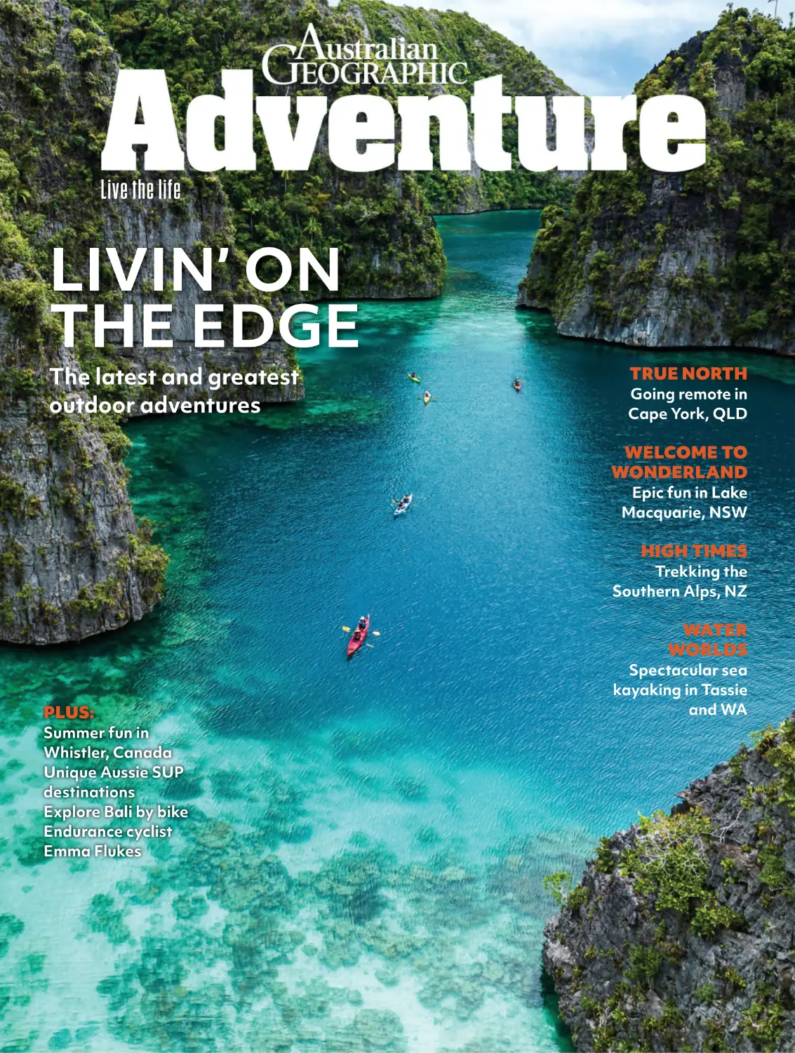
Live the life
LIVIN’ ON
THE EDGE
The latest and greatest
outdoor adventures
TRUE NORTH
Going remote in
Cape York, QLD
WELCOME TO
WONDERLAND
Epic fun in Lake
Macquarie, NSW
HIGH TIMES
Trekking the
Southern Alps, NZ
WATER
WORLDS
PLUS:
Summer fun in
Whistler, Canada
Unique Aussie SUP
destinations
Explore Bali by bike
Endurance cyclist
Emma Flukes
Spectacular sea
kayaking in Tassie
and WA
CONTENTS
Issue 11 March – September 2024
18
76
This Tassie endurance
cyclist proves the adage
of have bike, will travel.
Take your SUP to places
it’s never been before.
Profile: Emma Flukes
Australia’s secret
SUP escapes
24
82
It’s here, and bigger than
ever. Our latest bucket
list of dream adventures
for the next 12 months.
Trekking California’s High
Sierra section of the
Pacific Crest Trail.
Be there now
More than 40 days
and 40 nights
38
90
Come with us on a very
big adventure in this NSW
outdoor playground.
Paddling WA’s wild and
majestic northwest.
Exploring Lake
Macquarie
48
Kayaking Tassie’s
Freycinet Peninsula
Paddling in the Apple Isle
has never looked so good.
54
Trekking the
Southern Alps, NZ
A boot-borne journey of
discovery through the
South Island.
62
Best Aussie walks
Some of our favourite
treks in this legendary
country of ours.
70
Whistler in summer
There’s way more than
just skiing at Canada’s
iconic mountain town.
4 ADVENTURE
24
Dampier Peninsula
sea kayaking
54
98
Bali by bike
Get away from the
crowds on this twowheeled tour.
104
Cape York capers
A jungle epic rich in
culture and history.
110
90
Adventure
Classroom
Have a top night in the
outdoors with our guide
to sleeping bags.
116
Gear tests
Nemo sleeping bag, The
North Face jacket and
backpack, Oru kayak,
and the Nissan Navara
Pro-4X Warrior.
98
WHERE WILL THE
ROAD TAKE YOU?
PLAN YOUR NEXT ROAD TRIP
Taking in the
wilderness on the
ÙáïðÅëÝïðÖîÝåèÄÅ
ÇÆËÖÑÔ¬ËЬÅÊËÇÈ
Justin Walker
SENIOR DESIGNER
Mel Tiyce
ÕÇÐËÑÔÒÊÑÖÑÉÔÃÒÊÇÔ
Mark Watson
(inciteimages.com)
ÅÑÐÖÔËÄ×ÖÑÔÕ
Dan Slater, Fiona Harper, Marcus Craft, Carolyn Beasley,
Mattie Gould, Dean Miller, Andrew Bain, Lauren Sass,
Gemma Chilton, Toby Story, Dan Burnab, Paul Pichugin
ADVERTISING
ÄÔÃÐÆÃÐÆÒÃÔÖÐÇÔÕÊËÒÏÃÐÃÉÇÔ
Nicola Timm 0424 257 527, ntimm@australiangeographic.com
Å×ÕÖÑÏÇÔÕ×ÅÅÇÕÕÏÃÐÃÉÇÔ
Blaise Pearce
ÇÆËÖÑÔËÃÎÅÑÔÔÇÕÒÑÐÆÇÐÅÇÖÑ
Australian Geographic, 52–54 Turner Street,
Redfern NSW 2016 Australia.
Email: editorial@ausgeo.com.au
To the edge of the
world and back again
Live the life
LIVIN’ ON
THE EDGE
The latest and greatest
outdoor adventures
TRUE NORTH
Going remote in
Cape York, QLD
WELCOME TO
WONDERLAND
Epic fun in Lake
Macquarie, NSW
HIGH TIMES
Trekking the
Southern Alps, NZ
WATER
WORLDS
A
PLUS:
T THE TIME of writing (late February), it’s clear
that 2024 is going to be a bumper year for
travellers. For us at Aus Geo ADVENTURE, it’s
a prime time to revisit our bucket lists from before the
world shut down – and we suspect it’s the same for other
outdoor enthusiasts. For all of us, it’s been a bit of a waiting game, across a number
of fronts. Whether that is while patiently waiting for flight prices to drop (they are
still slightly eye-watering!), bank mortgages to do the same, or because you
decided to take a year to enjoy some normality, it looks like Australia – and the
world – is ripe for exploration. (Check our bucket list adventures, from page 24.)
Even with the big, wide world out there, you can often find memorable outdoor
experiences close by. This is perfectly illustrated by Senior Photographer Mark
Watson’s week in the Lake Macquarie region of NSW. With hiking, paddling, bike
riding, plus great accommodation and eateries, it’s impressive. Step further afield,
and be sure to read Fiona Harper’s roller-coaster exploration of Bali by bike. It’ll
open up your eyes to a whole other side of this popular destination.
When it comes to something that truly epitomises “adventure”, big mountains
are hard to beat. We’ve packed three separate feature stories in this issue with
mountain themes. From Mattie Gould’s sojourn in the NZ Southern Alps, to
Andrew Bain exploring the ‘other’ side of Canada’s Whistler, there’s plenty of
inspiration to be had. And then there is what must be one of my favourite all-time
stories: regular contributor Dan Slater’s Big Walk (note the capitals) along the
High Sierras section of the USA’s iconic Pacific Crest Trail. It is, as some are wont
to say, a “ripping yarn” and I am sure it’ll be a favourite for you all.
As well as hiking and biking, we haven’t forgotten one of Australia’s pastimes,
with a paddling triple treat. Andrew Bain reveals some lesser-known SUP
destinations in Oz, while Carolyn Beasley jumps in a sea kayak to explore WA’s
beautiful Dampier Peninsula. Dan Slater (yep, he’s back again!) also dips a sea
kayak paddle in the remote, beautiful Freycinet Peninsula down in Tassie. All
three stories will inspire you to get out on the water.
It’s while reading through this issue’s story list that I reckon I have solved my
problem of having to come up with my own bucket list. With all these inspirational
stories, I doubt I’d even tick half of them off in 10 years. Still, it is, as always, nice to
dream and I hope you all do the same after reading this issue. Enjoy!
Justin Walker
6 ADVENTURE
Summer fun in
Whistler, Canada
Unique Aussie SUP
destinations
Explore Bali by bike
Endurance cyclist
Emma Flukes
Spectacular sea
kayaking in Tassie
and WA
ÅÑØÇÔÒÊÑÖÑÉÔÃÒÊ
Sea kayaks exploring
the unique landscape of
Raja Ampat, Indonesia.
Photo Daniela Tommasi
Privacy Notice: This issue of Australian Geographic Adventure is
published by Australian Geographic Holdings Pty Ltd
(Australian Geographic).
Australian Geographic may use and disclose your information in
accordance with our Privacy Policy, including to provide you with
our requested products or services and to keep you informed of
other Australian Geographic publications, products, services and
events. Our Privacy Policy is located at australiangeographic.com.au/
privacy. It also sets out how you can access or correct your personal
information and lodge a complaint. Australian Geographic may
disclose your personal information offshore to its owners, joint venture
partners, service providers and agents located throughout the world,
including in New Zealand, Canada, the Philippines, and Europe.
In addition, this issue may contain Reader Offers, being offers,
competitions or surveys. Reader Offers may require you to provide
personal information to enter or to take part. Personal information for
Reader Offers may be disclosed by us to service providers assisting
Australian Geographic in the conduct of the Reader Offer and to
other organisations providing special prizes or offers that are part
of the Reader Offer. An opt-out choice is provided with a Reader
Offer. Unless you exercise that opt-out choice, personal information
collected for Reader Offers may also be disclosed by us to other
organisations for use by them to inform you about other products,
services or events or to give to other organisations that may use this
information for this purpose.
If you require further information, please contact Australian
Geographic’s Privacy Officer either by email at privacyofficer@
australiangeographic.com or mail at Privacy Officer, Australian
Geographic Holdings Pty Ltd, 52–54 Turner Street, Redfern NSW 2016
Warning: Activities found in Australian Geographic Adventure
can be dangerous. Undertake them only with proper instruction,
training or equipment. The Publisher, and its servants and agents
have taken all reasonable care to ensure the accuracy of the
information contained in this publication and the expertise of its
writers. Any reader attempting any of the activities described in
this publication does so at their own risk. Neither the publisher
nor any of its servants or agents will be held liable for any loss or
injury resulting from any attempt to perform any of the activities
described in this publication.
AUSTRALIAN GEOGRAPHIC ADVENTURE
is printed in Australia by PMP Print, 31–35
Heathcote Road, Moorebank NSW 2170
under ISO 14001 Environmental Certification.
Australian Geographic Adventure is published two times a
year (cover title Issue 001, Issue 002) by Australian Geographic
Holdings Pty Ltd (ABN 12 624 547 922), 52–54 Turner Street,
Redfern NSW 2016. The trademark Australian Geographic is the
property of Australian Geographic Holdings Pty Ltd. All material
© 2019. All rights reserved. No part of the contents of this
publication may be reproduced without the prior written consent
of the editor-in-chief. This issue went to press 22.03.2022.
Experience the World
from a New Perspective
Immersive Voyages Honed over 50+ Years
A CIRCUMNAVIGATION OF
ICELAND
10 Days | Jun & Jul 2025
Ships: National Geographic Endurance,
National Geographic Explorer
From Reykjavík, Iceland return.
There’s no better way to experience
authentic Iceland than on an
expedition to the country’s far
corners. Hike up mountain trails,
kayak in protected fjords, or take a
zodiac cruise around a seabird colony.
WILD GALÁPAGOS ESCAPE
7 or 8 Days | All Year Round
Ship: National Geographic Islander II
Quito or Guayaquil, Ecuador return.
Snorkel and kayak among colourful
fish, sea turtles, penguins, and
playful sea lions, and walk among
colonies of wildlife and seabirds
unfazed by your presence. See this
archipelago from a new perspective
with a local and veteran team
leading the way.
ANTARCTICA DIRECT: FLY THE
DRAKE PASSAGE
8 Days | Nov & Dec 2024, Jan &
Feb 2025
Ship: National Geographic Explorer
From Puerto Natales, Chile return.
Bypass the 48-hour Drake Passage
crossing, and take a two-hour
charter flight to and from Puerto
Natales. Without sacrificing the
additional time, witness Antarctica’s
legendary natural wonders and
majestic landscapes.
CALL US FOR MORE DETAILS 1300 361 012(AU) | 0800 444 462(NZ)
©2024 Lindblad Expeditions. Lindblad Expeditions and the Eye are the trademarks of Lindblad Expeditions. All rights reserved. ©2024 National Geographic
Partners, LLC. All Rights Reserved. NATIONAL GEOGRAPHIC and the Yellow Border are trademarks of National Geographic Society and used with permission.
ADVENTURE NEWS
New Osprey
Escapist
Bikepacking
gear!
R
ENOWNED PACK BRAND, Osprey,
posture riders plenty of comfort. The
has released its new Escapist
Airscape back panel keeps you cool/
bikepacking range, comprising three
ventilated, while the biostretch harness and
backpacks (made using bluesign approved
the hipbelt provide ample all-round
100 per cent recycled material) and five
comfort.
different types of frame bag, aimed at
keen bikepackers and cycle tourers.
ÇÕÅÃÒËÕÖÑЬÄËÍÇÈÔÃÏÇÄÃÉÕ
With the
assurance of
Osprey’s quality
construction,
these bags will
prove popular.
Designed as a complete, modular,
ÇÕÅÃÒËÕÖÑЬÄÃÅÍÒÃÅÍÕ
system, the Escapist On-Bike
The Escapist packs come in three volumes
frame bags can be fitted to a
– 30 litres, 25L and 20L. The Escapist 30 is
wide range of bike frames and
the big bopper that allows you to tackle
sizes. The saddle bag can even be
those longer journeys where this pack
adapted to fit with a dropper-post if
would be used in conjunction with bike bags
need be. The bags feature RF welded
to lug essential gear, while the 25 and 20
seams and waterproof zips, with the
respectively – to cater for different frame
are perfect for shorter, faster adventures
handlebar bag and saddle bag including
sizes and includes double-ended zips. The
without sacrificing functionality.
air purge holes to vent out pressure and
2L wedge bag is, as its moniker suggests,
add compression and stability when
steeper on one side than the other to allows
loaded on the bike.
for easy fitment to different shaped
Each Escapist pack includes nifty
bike-specific design features, such as
pockets that are easy-to-reach when you’re
The handlebar bag (10 litres) is of
frames. There is dual-side, waterproof zips,
on your bike, a large front pocket with
interesting construction, featuring two
and variable attachment points that
stretch material, lid lock helmet
pieces – a custom-mounting holster and
feature anti-scratch hook-and-look straps.
attachments, hi-vis rain cover, reflective
waterproof bag. The bag sits inside the
material and large buckles that are easily
holster on the bike. The 9L saddle bag is of
vertical access point, a cable exit, plenty of
used even when wearing gloves. The
similar, two-piece, design; the under-
attachment points and a structured,
Osprey designers also paid attention to
saddle holster secures the load to prevent
semi-solid outer for easier packing of your
how the pack sits on the rider, with the
sway, while the waterproof bag is easily slid
gear.
dropped lumbar keeping the weight down
out from the holster when needed.
on your sit-bones and the back panel’s
upper split allowing more aggressive8 ADVENTURE
The top tube bag (250ml) includes one
The frame bag is available in three sizes
– S, M, L, equalling 4, 3.5 and 2 litres,
More info: www.osprey.com/au/en/
Mooney Mooney
Image by Remy Brand
The NSW Central Coast is home to a
waterworld like no other in Australia.
This award-winning ECO Destination is defined by its interconnected waterways. With vast lakes
to the north, hidden natural creeks and lagoons deep in its national parks, and a stunning coastline
that welcomes early bird swimmers and sunset surfers – the Central Coast offers endless aqua
adventure! Whether wading in, paddling out, slipping under, walking by, swimming through or
admiring from the shore, these waterways and coastlines invite you to explore ashuckingly fresh
perspective of the destination – dive in!
#LOVECENTRALCOAST
Explore more
lovecentralcoast.com/waterways-coastlines
ADVENTURE NEWS
The ultimate
MTB road trip?
The NSW far south coast puts forward its case.
T
Above: The Gravity
Eden trails take
advantage of the
spectacular natural
environment.
HE NSW FAR south coast has, in the
past six months, transformed into
one of Australia’s best mountain
bike destinations, with two amazing MTB
destinations now flourishing, and a third (at
Left: Eden is
booming with MTB
tourism and more
than 40
international cruise
ships visiting each
year.
Mogo) due to open later this year. Gravity
Eden MTB Park, in the town of Eden, and
Narooma’s MTB network trail network both
offer some of the best riding in the country
and form the basis for an awesome
week-long MTB road trip, taking in not only
these two new trail networks, but also
Tathra’s iconic trails.
For Sydney/Canberra-based riders, this
road trip could also loop in Cooma’s cool
trails as well, with riders looping south from
Eden, to Tathra, then Narooma, enjoying
been a favourite of riders for years. Don’t
the brilliant riding at each destination.
forget to check out historic Tathra Pub for a
Gravity Eden MTB Park has more than
post-ride celebration.
these two cities to Cooma, before driving
58km of trails, catering for all rider abilities.
down the Monaro Highway’s Brown
Green rated trails weave through beautiful
rider types as well, with flow, jump, gravity
Mountain to Eden, and then working their
fern-laden forests (Garden of Eden is a
and XC trails to keep you entertained.
way north along the Princes Highway from
favourite), while the flow trails reside
Narooma’s 85km of trails
offers a mix of riding
experiences.
Narooma’s 85km of trails cover off all
Thanks to this region’s maritime climate,
midway up the hills behind
the riding is awesome all year round. Both
town, before you reach the
Narooma and Eden offer shuttle services,
second and third trailheads
too, plus all of these towns boast awesome
off Nethercote Road, where
cafes, pubs, accommodation options and
the gravity trails, such as
more to ensure a memorable week on and
Old Tom, begin.
off the bike.
Tathra’s flowy, natural
10 ADVENTURE
sand/rock-based MTB trails
More info: gravityeden.com.au;
are next, with its 50km trail
mountainbikenarooma.com.au;
network right behind town
tathramtbclub.com;
(and Tathra beach, for a
sapphirecoast.com.au;
post-ride swim!) and have
eurobodalla.com.au
ADVENTURE NEWS
Colorado’s
new Million
Dollar Trek
N
AMED AFTER COLORADO’s
famous “Million Dollar Highway”,
this new five-day, hut-to-hut trek
takes participants on an epic journey
covering more than 56km. San Juan
Mountain Guides has devised this new
adventure, and it looks amazing. Linking
Silverton and Ouray, the hike sees you stay
overnight in some of the area’s most schmick
backcountry lodges (the Ophir Pass
Ultimate Ski Hut, Red Mountain Alpine
Lodge and Mt Hayden Backcountry Lodge).
The landscape you walk through lives up
to its reputation as spectacular. Hikers will
traverse old gold-mining roads, tackle crosscountry sections, pass alpine lakes, and
lodges aside, you have the benefit of not
negotiate some amazing ridgelines and
having to lug all your gear – you will only
high summits (for us Aussies) before
need daypacks (with lunch and essential
most spectacular mountain areas in the
reaching the hut, and the awesome,
gear for the day) for the between-hut treks
USA, this supported trek is a no-brainer.
chef-prepared, food on offer at each.
– plus your trekking guides are IFMGA/
Awesome scenery and comfortable
AMGA Mountain Guides, so you know you’ll
be in very capable hands.
For those looking to explore one of the
For more info, see https://mtnguide.net/
trips/trekking/million-dollar-trek/
Epic rafting in Morocco
W
E’RE BIG PADDLING fans at Aus Geo
ADVENTURE so when an all-new
paddling adventure crops up, we get
excited. And in the case of the new World
Expeditions Morocco Rafting Adventure, our
excitement is more than warranted.
This eight-day trip includes four days of rafting
the mighty Ahansel River, in Morocco’s Middle Atlas
Mountains, and is graded intro to moderate. The
trip itself kicks off in Marrakesh (yep, you get the
chance to check out that city’s famous markets)
before you immerse yourself in this unique river
journey. Paddlers will camp along the way during
the rafting segment of this trip, before enjoying
four-star accommodation when off the river.
As you’d expect, World Ex has a group of
excellent raft guides for this trip, with each of them
having a minimum of 10 years’ river running
experience under their belts. Gear supplied includes
life jacket, helmet, wetsuit, spray jacket, Pelican
case and waterproof gear bag for all your personal
stuff. You will raft for an average of four to five
hours each day, giving you plenty of time to explore
the landscape (think: glades and deep gorges) you
are floating through.
For more info on dates and costs, check out
www.worldexpeditions.com
LIVE THE LIFE 11
OUT THERE
12 ADVENTURE
Desert camp, Hay River Track, QLD
The Madigan Line is one of Australia’s most iconic – and challenging – 4WD adventures. This track
follows the historic route of explore Cecil Madigan across the remote northern Simpson Desert. It can
take between six and 10 days, and you need to be fully prepared with all your food, fuel and water.
During the trip, you will traverse more than 1000 sand dunes and, at the end of each day, enjoy some
of the best campsites in the world. This camp, beside the Hay River Track, is near the end of Madigan’s
route and around two days’ drive from the outback Queensland town of Birdsville.
Photo: Justin Walker
LIVE THE LIFE 13
HIT THE ROAD
IN NORTH
QUEENSLAND
With unique locations, jaw-dropping
experiences and dinky-di Aussie
characters, North Queensland is
the place for your next road trip.
WORDS BY HELEN HAYES
14 ADVENTURE
N
OTHING SHOUTS ‘ROAD TRIP’ more than singing
along to your favourite tunes as you head down the
highway in your rig. This one is a classic: “Ridin’ down
the highway, goin’ to a show, stop in all the byways,
playin’ rock ‘n’ roll…” It’s a long way to the you-know-what.
Stopping in the byways is the best thing about a driving holiday.
The tiny blink-and-you’ll-miss-it-towns, the truck stops, the sleepy
villages, the pubs. Nothing beats a country pub, and North Queensland
has a bunch of ‘em, full of stories, chockers with characters and good
cheer, along with good beer of course. And no matter whether you
are a grey nomad, adventure lover, beach bum or a backpacker, a cold
one after a dusty drive tastes heavenly.
So, if you’ve got your gear ready – your caravan, camper trailer,
campervan, motorhome or just your tent or new-fangled swag – start
planning your next road trip exploring the wonders of North
Queensland.
Tropical North Queensland
All roads lead to Cairns – well, these four beaut drives do. With a
kaleidoscope of colours from that blinding blue of the sea to the
velvety green of the rainforest and the ochre red of the outback,
nature is front and centre on these itineraries.
The Savannah Way is a humdinger of a drive, stretching through
three Aussie states and territories, on a mind-blowing 3699km of
outback. Don’t panic if you don’t want to do it all, just do the best bit
– the Queensland section! This part of this legendary road bumps
you from Hell’s Gate to Cairns, and there are plenty of brilliant places
to check out, including Boodjamulla (Lawn Hill) National Park, and
Riversleigh Fossil Fields.
The Great Green Way runs between Townsville to Cairns and
the name is spot on because you’ll go through 12 national parks along
the way. Think waterfalls, magical waterholes and cool seaside towns.
Oh, and get a selfie at the giant gumboot – complete with frog – in
Tully. We do love our big things in ‘Straya, don’t we!
Exploring Cape York and the Daintree are true bucket-list
adventures, absolute gold for those who like to drive to the back of
beyond and then some. Cape York is normally accessible through
winter and spring, but it is so popular you’ll often need to book at
least six months ahead. While the weather had been a little rough
LIVE THE LIFE 15
The Queensland
Outback offers some
amazing road trip
opportunities.
last year, parts of the Daintree are back up and running, opening
up the wondrous Heritage-Listed Rainforest with its ancient
ferns and tangled canopies, fringed by the Great Barrier Reef.
The Great Barrier Reef Drive is fine from Cairns to Port Douglas,
with those drop-dead gorgeous ocean views woven into canopies
of green just as divine as ever. Chill out in Palm Cove, and linger
longer in Port Douglas where you can get snappy on a croc tour,
or get wet out on the Great Barrier Reef.
Outback Queensland
You won’t have a more Aussie experience than on one of four
brilliant road trip options in Outback Queensland. Even the
names are awesome: Overlanders Way, The Matilda Way, Dinos,
Crocs and Gold, and the Australian Dinosaur Trail. The Overlanders
Way is a tad over 1,000 clicks and takes you from Townsville’s
idyllic beaches to Camooweal… without leaving the bitumen!
Say g’day to locals in cracker towns like Charters Towers, Julia
Creek, Cloncurry and Mt Isa, with a whole rodeo of dinosaurs,
fossils and cowboys. Don’t forget your Akubra so you look the
part!
The Matilda Way is another fully-sealed highway, stretching
from Cunnamulla on the New South Wales border to Karumba,
on the Gulf of Carpentaria – a hefty distance of 1812 km. Go
stargazing in Charleville, watch the chicken racing at the Royal
Carrangarra Hotel, head to the Black Stump at Blackall, marvel
at ‘Machinery Mile’ in Ilfracombe, get your pioneering hat on in
Longreach and ‘Waltz Matilda’ in Winton.
If you know your Stegosaurus from your T-Rex, venture out
along the Australian Dinosaur Trail, which is a 735km doddle in
prime fossil country encompassing Richmond, Winton and
Hughenden. In Winton, visit the Australian Age of Dinosaurs
and learn about the ‘dinosaur stampede’ at the Lark Quarry
Conservation Park. Say g’day to Hughie, a Muttaburrasaurus, at
16 ADVENTURE
The Overlanders Way takes you
from Townsville’s beaches to
Camooweal, all on bitumen!
DRIVE NORTH QUEENSLAND
the Flinders Discovery Centre in Hughenden, and soak up some
amazing country by camping at Porcupine Gorge National Park.
For a great combination, Dinos, Crocs and Gold is a round
trip from Townsville covering an epic 2934km. Spot freshwater
crocodiles on a Cobbold Gorge cruise, be totally wowed at the
Undara Experience, and head from Hughenden to Richmond
and Kronosaurus Korner – Australia’s premier marine fossil
museum.
Townsville
Get some Ayr (see what I did there) on one of these beaut drives
in the Townsville region. Check out the North Queensland
Highlights route through the Burdekin from Ayr to Ingham. It’s
sweet in more ways than one, with the Burdekin Art Trail, a
shipwreck to scuba dive on, the gorgeous Magnetic Island to
explore, a host of critter experiences in Townsville, and for
something different, check out the largest herd of Texas Longhorn
cattle in Australia, at Charters Towers.
Ayr is also the starting point for the North Queensland Island
Hopper experience. An hour’s drive north in Townsville, you can
embrace your inner aquaman at Magnetic Island. Test out each
of its 23 beaches and see koalas in the wild. Flit away from Maggie
on a helicopter to Orpheus Island, then head to Hinchinbrook,
after a sojourn back in terrific Townsville.
If you love animals, the North Queensland Wildlife Tracker
could be spot on for you. From Ayr to Hinchinbrook Island, you’ll
see a raft of feathered, furred and scaled critters at places like
Cromarty Wetlands north of Ayr, and diving with sea life on the
SS Yongala. In Townsville, get your wild on at the Town Common
Conservation Park or the Billabong Sanctuary. On ‘Maggie’, visit
between May and August and experience the butterfly walk at
Horseshoe Bay.
The Whitsundays
Top: The Winton Age of Dinosaurs is part of the
brilliant 735km Australian Dinosaur Trail.
Below: Go deep off the coast and check out one of the
world’s natural wonders, the Great Barrier Reef.
Ah, The Whitsundays. The Heart of the Great Barrier Reef. Such
a beautiful part of the world, with its 74 islands and many mainland
wonders as well. It’s so easy to explore The Whitsundays – either
drive your rig up here or fly in and hire a car or campervan. Easy
peasy. As to which drive to take, the Adventures in The Whitsundays
drive runs from Cedar Creek Falls to Bowen, and you can swim
and paddle your heart out in blissful waterholes like the one at
the base of the Cedar Creek Falls. Laze at postcard-perfect
Hydeaway Bay north of Airlie Beach and knock back a bevvy or
two at one of the beachfront resorts there, and in Airlie, jump in
for a swim at the massive lagoon or take a dip at Boathaven Beach.
Head north to Bowen, where it’s all about mangoes – you can eat
‘em, and tick off another ‘big thing’ – the Big Mango – before
washing off those juices at the stunning fringing reefs just off the
shore of Horseshoe Bay. While in town, savour the best seafood
around – grab some fish and chips at Birds Fish Bar at Bowen
Fishermans Wharf. Is there anything better than fish ‘n’ chips
by the water? Nah.
For more Whitsundays goodness, check
out the Cairns to Whitsundays drive. If
you’re travelling from the south, try the
Ultimate Guide to Driving the Great Barrier
Reef from Bundaberg – hello Bundy Rum!
– to Cairns, or strap in for the what-theheck-let’s-do-it drive from Brisbane to the
Whitsundays, taking you along 1268km
of tropical coastline to North Queensland.
So you should be all revved up now to
drive those highways and byways and dirt
tracks, whether in your own rig or in a
hired vehicle. Whichever drive you take;
A
it will be a ripper! Cue AC/DC…
Find your ultimate North Queensland road trip at drivenorthqueensland.com.au
Best to be totally prepared, so remember to always check road and weather conditions before you travel.
This article is brought to you by Drive North Queensland.
LIVE THE LIFE 17
Emma riding out of Hobart at the
2019 Gift. Tassie’s inclement weather
adds another layer of challenge (and
occasionally snow) to the epic
bikepacking event.
18 ADVENTURE
PROFILE: EMMA FLUKES
GIFT OF
ENDURANCE
From her punishing initiation in the 2018 Race
to the Rock, to founding one of Australia’s
toughest bikepacking events, Emma Flukes
has overcome relentless adversity to become a
powerhouse in Australian endurance cycling.
WORDS: GEMMA CHILTON PHOTOS: DAN BURNAB
“I
HAVE NEVER experienced the sensation of literally
wanting to crawl under a tree and die with such
frequency and ferocity as I have over the past couple
of days,” wrote Emma Flukes on her Instagram (@
oneflukeshot) back in September 2018.
She was in the middle of her first-ever endurance bike ride, the
2018 Race to The Rock – 3,602 km from Cockle Creek in far-south
Tasmania to Uluru in the Northern Territory. And while it might
not sound like it by her reflections at the time (nor, I imagine, have
felt like it) – that was the adventure that kickstarted a love of
bikepacking that would see Emma, within just a couple of years,
become one of the most renowned and experienced endurance
cyclists in the country.
A marine ecologist by day, Hobart-based Emma finished her
PhD in environmental science back in 2015, when she was 24 years
old. While she’d always been active, including as an internationally
competitive sailor as a teen, cycling had never been her sport of
choice. “I hadn’t been on a bike since I was about 10 years old,” she
says.
Like riding a bike
However, towards the end of her PhD – on the insistence of a mate
– Emma started dabbling in a bit of bike riding. She started out on
a road bike – as long-distance mountain biking wasn’t really on the
radar at the time, at least locally, she says. (“There was this weird
perception that mountain bikes were too slow.”)
But before long, Emma realised sharing the road with cars wasn’t
her idea of fun. “It’s so much nicer being in the bush, so I just started
taking my dual suspension, cross-country bike for all-day rides,”
she says.
Her burgeoning interest soon extended to “dot-watching” –
following the GPS locations of racers in big international events
like the US Tour Divide. Then she heard that the 2018 Race to the
Rock event would, serendipitously (and for the first and only time)
kick off in her home state.
Emma says it took a while to admit to her friends about her
new-found desire to ride unsupported half-way across the country
– but finally she plucked up the courage to confess to her partner
(who she says is a ‘normal’ road cyclist and mountain biker).
“He was like, well, we’d better get you a bike then.”
Homemade gear solutions
Emma says finding the right bike for the race wasn’t straightforward
(she’s petite, with a short torso). Building a custom bike was out of
the budget, so she instead found a small enough previous-model
Canyon hardtail “in the bargain bin”. Then she had to figure out
bike bags – there weren’t a lot available in Australia at the time,
with the bikepacking scene still fresh.
“There were no neat solutions, so it became this real homemade
exercise,” she says.
A month of forum research and eBay-hunting later, Emma had
her setup ready to go and took it on a practice run to Ouse – a small
town in Tassie’s central highlands. “I did that, slept on a park bench,
and didn’t die. I thought, yeah, this is fine.”
For the Race to the Rock, Emma gave herself two days (sans
sleep) to ride across Tasmania from Cockle Creek to Devonport
in time to catch the Spirit of Tasmania across the Bass Strait. She
missed the ferry and had to hang out for the day until the next one.
In the end it took her a total of 18 days to reach the Rock – making
her the last, but also one of only four out of nine starters, to finish
the epic journey.
Emma had ridden through painful ITB (iliotibial band) twangs
and grappled with extreme isolation and sleep deprivation that
took her to some dark places – like thinking “when I die tonight,
I’m closer to Finke than Oodnadatta. I don’t want the recovery to
be confused by a border issue,” she wrote in that same Instagram
LIVE THE LIFE 19
PROFILE: EMMA FLUKES
Fording a water
crossing on the
2021 Tassie Gift, a
year that finished
with a DNF when
Emma was struck
with illness.
post. However, she returned from the experience not traumatised,
but galvanised.
“I often think back on [that trip], and if I was to do it again, it
would be so easy now,” she says.
Emma’s gift to Tassie riders
The next year, in 2019, Emma was back on the mainland to compete
in a 400 km bikepacking race in Victoria. She had also started
spending a lot more time bikepacking around Tassie on her own
– and was soon looking back on that Tassie leg of the Race to the
Rock thinking “surely that can’t be the best Tasmania has to offer”.
“I started exploring more. And because I enjoy racing and geeking
out with maps, I thought, ‘I’ll put together this route, and I’ll put
on an event’.”
The event was called the Tassie Gift and it kicked off in November
2019. Described as “a scenic trip to Hell” the unsupported (and
“unsanctioned”) 1,796 km bikepacking route is almost entirely
off-road through Tasmanian wilderness. It starts and finishes in
Hobart, kicking off with a long climb up kunanyi/Mt Wellington
before traversing the central and cradle plateaus to Arthur River,
heading back down the west coast through takayna/The Tarkine,
before an almost mirrored loop on the eastern half of the state,
taking in Derby, St Helens, and Orford.
In establishing the route, Emma says she not only considered
the best of Tassie’s off-road tracks, but also drew on her experiences
from previous races. For example, she says she hates when a section
is particularly sketchy or gruelling for no apparent reason, with a
more straightforward route in the same area. “To me that feels
gratuitous. Like, here’s this really shitty section just because we
want to make it adventure-y,” she says.
“With the Gift, if there’s going to be hard stuff, then it has to
exist for a good reason, like an amazing view. And I’ve had that
feedback from past riders who say, ‘we started to expect that when
the going got tough, you knew there was going to be a big reward’”.
Emma finished first on the inaugural Gift in 2019 (“I feel like
a bit of a wanker saying I won my own event!”), then in the second
event in 2020 she says she had a great “battle” with Tasmanian
multi-sport and adventure athlete Alex Hunt, who finished first
in the end – Emma just a few hours behind him.
Grave decisions
Fast-forward a few months ahead of the fourth annual Gift, in
around July 2022, and Emma caught a virus (“probably COVID”),
her symptoms deteriorating quickly. By August she was diagnosed
with an autoimmune disorder called Graves’ disease, which causes
the immune system to attack the thyroid – presenting a range of
symptoms that differ among individuals.
“You feel like you’ve had 10 coffees,” is how Emma describes
her symptoms. “You’ve got the shakes, you’re not focused. You’re
basically in a state of fight or flight, but permanently. And then it’s
combined with this thing called thyrotoxic myopathy – where your
muscles just stop working.”
Lonely roads
and desolate
scenery in
outback
Victoria during
the 2018 Race
to the Rock.
20 ADVENTURE
“… because I
enjoy racing and
geeking out with
maps, I thought,
‘I’ll put together
this route, and I’ll
put on an event’.”
Cycling through Annuello Flora and
Fauna Reserve in north-west Vic
during the 2018 Race to the Rock.
Pic: NorthSouth Studios
The 2022 Race to the Rock was coming up, and Emma had
liked the sound of the proposed Sydney to Adelaide route – but
her health wasn’t cooperating. Instead, she decided to try a shorter
bikepacking trip closer to home, in southwest Tassie, to see how
she fared.
“I was not alright,” she recalls. “I was having to stop just to
breathe and get my heart rate down.”
However, by the time the Tassie Gift did come around in
November that year, Emma was managing her symptoms with
medication, and she decided she was up for the race. Her heart rate
– the main concern – did settle a few days in, but that didn’t end
up being the main challenge she faced on that event, which she
calls “a comedy of errors”.
Pain in the neck
Shermer’s neck is a condition that only affects endurance cyclists.
Named after Michael Shermer, who first experienced it in
the 1983 Race Across America, it presents as pain and extreme
weakness of the neck muscles.
While the cause of Shermer’s neck – which appears to
impact endurance cyclists at random – is unknown, Emma
wonders whether going over the handlebars on a rough part
of track in the central highlands (followed by a few sleepless
nights) created the conditions for the bout that hit her.
She recalls riding through the night, helmet light craning
to see through thick fog on the corrugated Western Explorer
track through the Tarkine Wilderness. “It’s a stressful condition
for my neck, but I’ve done that many times,” she says. Then
not long after, riding on a four-wheel drive track towards the
West Coast mining town of Zeehan, her neck muscles started
cramping.
“I called my partner and I realised that my voice was all
messed up because everything was spasming,” she says.
Emma found she could manage the cramps if she held her
head in a certain position and ended up having to walk her
bike most of that track – unless she was on an uphill climb,
which changed her positioning enough to allow her spine to
better support her neck.
In hindsight, Emma says she probably should’ve looked for
a neck brace or something to help when she got to Zeehan
– but she had hoped the condition would resolve itself. “The
problem was, as soon as I got off the bike, there was no indication
anything was wrong,” she says. But after a couple of hours back on
the bike, Shermer’s was back.
Luckily, she was soon on a long smooth section of road, which
meant she could arrange herself to support her neck – but with no
pharmacy for 500 km in either direction, Emma knew she had to
think of solutions. “I ended up with this big bit of rubber, I think
LIVE THE LIFE 21
PROFILE: EMMA FLUKES
Emma loves that
her bike enables
her to explore
hundreds of
kilometres of
changing
landscape and
terrain.
From illness and injury to red tape, Emma’s bikepacking journey
has had more ups and downs than Tassie’s gnarly terrain.
22 ADVENTURE
Made it to the Rock! In 2018, Emma was a
relative newbie to the bikepacking scene,
but that didn’t stop her tackling a 3602 km
race from southern Tasmania to Uluru.
it was from a truck tyre, and I fashioned it into a sort of neck brace,”
she says.
With her foraged truck-tyre neck brace plus a pulley system
she devised by tying her helmet to her sports bra “like a
marionette doll”, Emma made it to Longford in Tassie’s
northern midlands, where she found a real neck brace (which
she says helped, “maybe 20 per cent”).
“I just kept getting up each day and asking, do I want to
do this? And I’d try one more day. I’m stubborn.”
Eventually she also changed the positioning of her handlebars,
which was uncomfortable for her wrists, but helped her neck
recover to the extent that she, incredibly, finished the race
sans neck brace.
Pushing limits
Of course, bikepacking for Emma is not all about enduring
pain and discomfort – she’s stubborn but not masochistic.
She loves that her bike enables her to explore hundreds of
kilometres of changing landscape and terrain, and that
“theoretically, I could just keep going forever. You just need
food”.
She says bikepacking has not just taken her to beautiful
corners of the country – she recently raced from Adelaide to
Port Augusta, then “speed-toured” her way home via the
Flinders Ranges – but has also honed her self-sufficiency and
taught her patience and flexibility in tough situations (“which
I wasn’t good at before, because I’m very type-A,” she says).
Emma doesn’t think you need to be an experienced cyclist
to get into endurance bikepacking – she wasn’t, after all.
Capability outdoors is helpful, but most important, she reckons,
is self-reliance and flexibility. “The earliest DNFs are always
the people who turn up with a big ego and big expectations,”
she says.
“I’ve never been the slowest rider, but I’m not fast either,”
she adds on her own ability. “But I don’t feel that much
different at the end of the day to at the beginning of the day.”
And while Emma’s Graves’ diagnosis presents a new normal,
she will have to manage going forward, she says she will learn
what that looks like by pushing her own limits to find out
where they now lie.
The 2023 Gift saw misadventure strike again for Emma,
who was a DNF after being struck by a bout of illness about
300km from home. However, the race itself was another
success, drawing 30 riders from across the globe – 16 of whom
made it across the finish line. But Emma has voiced concerns
about the future of the event, with its increasing popularity
and attention bringing more red tape and bureaucracy, which
she says is going to necessitate some “tough decisions’ in the
coming months – but given the community support and
enthusiasm for the race, she’s committed to find the right
compromise so that the Gift can keep on giving.
For now, she’s gearing up for her next race – the 2024 Tour
de Waipounamu, which traverses the length of New Zealand’s
South Island. “There’s plenty of rough terrain and bike carrying
on that route, but I’m hopeful that’ll be a happy redemption
A
ride,” she says.
LIVE THE LIFE 23
BE THERE
NOW
Yes, we know you know; the world is a very
big place. It’s a well-known fact, and a very
encouraging one for adventurous travellers.
And yes, the year has already started, but
we reckon there’s still time to add at least
one of these epics from Oz or the rest of the
world to your 2024 bucket-list. Here goes…
WORDS AUS GEO ADVENTURE
24 ADVENTURE
The various via ferrata routes
above Banff, in Alberta, offer
eye-catching views over this
famous town and its surrounds.
LIVE THE LIFE 25
Hike the Jatbula Trail, NT
If the Larapinta Trail is the perfect NT Red Centre
experience, then the 62km Jatbula Trail more than
qualifies as its Top End equivalent; the six-day walk is
moderate in level but takes you through some of the
most vibrant and engaging terrain in this country. It
can be walked independently (you need to book well
ahead for park camping/passes) or you can jump on
board a guided adventure with tour operators such as
World Expeditions.
The Jatbula is located in Nitmiluk National Park and
winds north (you can only walk it in this one direction)
from Nitmiluk (Katherine Gorge), which is well worth
a few days’ exploration, to Leliyn (Edith Falls). The
route takes walkers on a tropical walking adventure
along the western edges of the Arnhem Land Escarpment,
experiencing savannah grasslands, rocky quartzite cliffs,
creek-crossings, and exploring monsoon forests, with
each day ending at the perfect campsite: right beside a
cooling waterfall. This is Jawoyn country, and you’ll
get the chance to spot brilliant rock art in a number of
caves and rocky overhangs and outcrops as you trek an
average of 10km each day (the longest stretch is 16km
on Day 3, from 17 Mile Falls to Sandy Camp Pool)
between campsites.
The first few days are spectacular as walkers traverse
26 ADVENTURE
what is known as “stone country” before entering some
pockets of monsoonal rainforest that are characteristic
of the region. After a few days you’ll follow a gentler
track as you walk beside the pretty Edith River to Sandy
Camp Pool, where you’ll camp for the night, and then
through paperbark forests and past more waterholes to
Sweetwater Pool.
The hike is brilliant and can be done at a nice leisurely
pace but be sure to start early each morning so you can
take full advantage of the campsites’ locations right next
to waterholes where you can swim and cool off during
the afternoons. The trekking season is July to September
up here, so as well as warm days and cool-ish nights,
you should see plenty of stars in the clear NT skies.
In addition to the brilliant overall walking experience,
the fantastic campsites and the rich indigenous history,
the Jatbula’s start- and endpoints are ideal if you’d like
to spend more time here doing day walks through
Nitmiluk National Park or canoeing up the gorge or
down Katherine River.
Alternatively, you can simply keep that waterfall
spirit alive and spend a few days lolling about at Leliyn
at the end of your tropical trekking adventure.
More info: parksandwildlife.nt.gov.au/parks/walks/
jatbula-trail-nitmiluk-national-parks
Ride the Tour Aotearoa, NZ
The Tour Aotearoa is touted as one of the world’s best
cycle touring/bikepacking adventures, topping out at
around 3000km, and linking the tip of New Zealand’s
North Island, at Cape Reinga, to Bluff, at the bottom of
the South Island.
Originally dreamed up as a non-competitive cycling
event by Kiwi cycling guidebook author/expert, Jonathan
Kennett (the first Tour Aotearoa kicked off in 2016), the
event, run across February and March, has become incredibly
popular. Originally held every two years, from 2020 the
Tour Aotearoa is now an annual event and nearly always
sells out (for event information, seetouraotearoa.nz/p/
home.html). Riders in the event have 45 days to complete
the route.
Thankfully, this same route can also be ridden any time
of year by any type of rider, which has, as mentioned earlier,
seen this epic experience go to the top of many bikepacking
and cycle tourer bucket-lists. It’s easy to see why, too, with
the route encompassing some of NZ’s best trails and tracks
(on- and off-road) as it takes riders through the two islands’
famously diverse landscapes, and past some of its iconic
landmarks and historic sites. You’ll kick off at the Cape
Reinga Lighthouse at the start and, at some point days or
weeks later, you’ll have to duck into the iconic Cardrona
Hotel deep in the South Island for an encouraging ale or
two. Add in plenty of steady climbs and fun descents,
welcoming towns all the way, and that famously wild West
Coast of the South Island, and it’s not hard to understand
the ride’s general appeal.
And speaking of general: as there’s no time limit, and
oodles of towns along the way, your own version of the Tour
Aotearoa can take as long – or be as short – as you like.
Accommodation options range from hotels and B&Bs, to
caravan parks (with hot showers!) and bush campsites, each
of which will form part of your own Tour Aotearoa story.
In terms of rider skill levels and fitness, the route is suited
to any rider with a modicum of general fitness. There’s no
“one” type of bike that suits the Tour Aotearoa, either. From
gravel bikes and single-speed steelies, to mountain bikes
and e-bikes, you can choose whatever you wish as your TA
rig. The Kennett brothers (Jonathan, along with siblings
Paul and Simon) have been writing, photographing, and
supporting cycling growth in NZ for decades, and publish
two excellent, must-have pocket guidebooks, one covering
the North Island, the other the South. They also publish
other NZ-based cycle guides (go to kennett.co.nz).
These, plus a GPS and maps, are key requirements, and
then it all comes down to you, you’re planning, and your
bike, to create a lifelong cycling memory. And for those
who haven’t figured it out, yet: yes, it’s on the Aus Geo
ADVENTURE team’s bucket-list!
More info: nzcycletrail.com
LIVE THE LIFE 27
Trek the Mt Anne Circuit, TAS
The Mt Anne Circuit, deep in the Apple Isle’s wild and
rugged south-west, is a ripper challenge for experienced
hikers, over three or four days, and covering around
35km. But don’t let that short timeframe or distance
fool you...
Located around three hours’ drive from Hobart,
you could be forgiven for thinking you’ve arrived in a
different land and time. The Mt Anne Circuit packs
in everything an experienced hiker could wish for:
towering rocky peaks to ascend, an immense boulder
field to traverse, huge alpine lakes to camp beside and
the real chance you’ll cop every aspect of Tassie’s
renowned wild weather – regardless of the time of year.
The first day is slightly deceiving, with a gradual
(and relatively short, timewise) ascent to High Camp
campsite, nestled in the shadow of Mt Eliza, looking
over the immensity that is Lake Pedder down below
where the track starts. The second day ramps up the
excitement; firstly, climbing up the slopes of Mt Eliza
before traversing its namesake plateau. After this, you
can drop your pack and tackling the side-trip up to the
summit of southwest Tassie’s tallest peak, 1423m Mt
Anne. It’s a scramble/climb to the summit, with a bit
of exposure along the way, but worth it; the views from
here at next-level and, as well as peaks such as Mt Lot
28 ADVENTURE
in the distance, you also get your first glimpse at what
must be one of Tassie’s most spectacular campsites:
Shelf Camp. Descending from the summit and then
heading back to the track junction to pick up packs, it’s
only another half-hour to Shelf Camp.
It is day three that will stand out in most memories;
from negotiating a giant boulder field not long after
Shelf Camp, to then negotiating the infamous Notch
(you’ll get to test climbing skills here) before ascending
Mt Lot’s north face and tackling the exposed descent
from Lighting Ridge to camp at Judds Charm, beside
Lake Judd, you’ll be pumped the entire way. It’s only
4km overall but it will take a full day. And yeah, you
will sleep like the proverbial at Judds Charm that night.
The last day sees you traverse, then descend from,
Sarah Jane Plateau before tackling the long and often
very muddy Anne River plains before crossing the
aforementioned river and arriving at track’s end at Red
Tape Creek. Yep, the Mt Anne Circuit redefines the old
adage of “short and sweet” and delivers big-time when
it comes to an entertaining and sometimes challenging
sojourn through one of this country’s most remote and
spectacular areas.
More info: ì÷îçïðÝïãëòÝñáôìèëîáëñîìÝîçïïëñðäóáïð
êÝðåëêÝèìÝîçéëñêðÝêêáßåîßñåð
Explore the Great Ocean
Walk, VIC
From cliff-top vistas to surf-pounded beaches and eucalypt
woodlands, this 100km multi-day trek showcases the best of
coastal Victoria. The walk starts at Apollo Bay, 150km southwest
of Melbourne. The track clings to the coast along the Otway
Range, through patches of eucalypts and rainforest, then up
over undulating cliff tops and hills, and down to wind- and
wave-battered beaches. Everyone must walk in a westerly
direction towards the walk’s iconic end point at the Twelve
Apostles.
The beautiful and varied walk is notionally split in two – the
‘mild side’ in the east, from Apollo Bay to the Aire River
campsite; and the more dramatic scenery of the ‘wild side’ in
the west, from Aire River to the Twelve Apostles. The most
spectacular views are found in these western sections, where
walkers climb to some of Australia’s highest sea cliffs at
Moonlight Head and spy remnants of the many ships sunk
along this tract of the Shipwreck Coast at Wreck Beach.
This relatively easy track is suitable for hikers of different
levels, from novices to experienced bushwalkers (keep an eye
on tides and weather, though, as these can close some sections).
You can do things solo – carrying your own food, water and
gear, and staying at the basic campsites along the way – or you
can go with one of the guided options and get dropped off at
the track and then picked up each day and driven to local
accommodation. You can also choose a day walk at any point
if you can car shuffle or book a taxi.
More info: greatoceanwalk.com.au
Yasawa sea kayak expedition, FIJI
Fiji’s Yasawa Islands, a remote chain of 16 islands
to the north-west of the country’s main island, are
the perfect bucket-list addition for keen paddleborne explorers.
This specific archipelago has been the go-to
destination for Aussie paddle touring company,
Southern Sea Ventures, for the best part of 30
years. The company’s most adventurous offering
here is the guided nine-day Yasawa Tropical Kayak
Expedition. On days three to seven of the trip, a
small group of paddlers (maximum 10) and their
two guides will rise with the sun to kayak between
islands, with plenty of opportunities for snorkelling
through colourful tropical reefs, mixing with local
communities, and camping on secluded beaches.
Covering about 90 km in total, this fully guided
kayak trip is appropriate for experienced paddlers and fit
beginners. SSV provides all the kayak, camping and safety gear,
and the paddling part of the trip is fully catered, with meals
cooked up by the guides – so while this expedition packs in
adventure, it’s far from roughing it!
Highlights of the Yasawa Tropical Kayak Expedition include
exploring the village of Navotua; paddling around the
limestone peaks and saltwater caves of stunning Sawa-I-Lau
Island; and snorkelling the vibrant coral reefs of Blue Lagoon.
The adventure finishes with an overnight resort stay, which
comes with the chance to swim with manta rays.
More info: southernseaventures.com
LIVE THE LIFE 29
Family adventure: Cape York, QLD
Still one of the great family four-wheel drive camping
experiences in this country, the trip to the tip of Australia
has retained much of the region’s wild frontier feel, even
today, thanks mainly to the fact it is simply so far away.
Just getting to the start point of Cairns – and the Peninsula
Development Road (PDR) that leads north from this
tropical city – can take a week.
It is not until drivers hit Cooktown, that you’re properly
in Cape York country. Cooktown is worth a few days’
exploration (and fishing), before resupplying for the next
leg north along the PDR. Most smart travellers will allow
at least three weeks to ensure they can take all the main
side-trips, such as the drive to Cape Melville (inside the
same-named national park) for some awesome camping
at the cape itself. This park is reached via the beautiful
Rinyirru (Lakefield) NP, not far north of Cooktown.
Continue north along the PDR and you’ll pass famous
Cape York landmarks, such as Archer River Roadhouse
(and nearby Mungkan Kandju NP) before reaching the
junction with the Telegraph Road (TR). Stick to the PDR
as it veers left and you’ll reach Weipa, home to the world’s
largest bauxite mine, and also home to some awesome
fishing and boating, as well as the Napranum Cultural
30 ADVENTURE
Centre, just to the south. It is easy to double back to the
Old Telegraph Road (OTR) from Weipa and continue
north, taking the time to stop at Moreton Telegraph
Station, and camp at Bramwell Station (Australia’s most
northerly cattle station).
You have a decision to make at Bramwell Junction:
follow tradition and take the OTR, or veer right onto the
Bamaga Road, which bypasses a number of the OTR’s
water crossings – including infamous Gunshot Creek, as
well as, further north, Mistake Creek and the mighty
Jardine River – before re-joining the OTR about 60km
south of the last major centre, Bamaga.
From Bamaga, it is a short jaunt north to the top-most
point of Australia, but there’s still plenty to see in this area.
The WWII-era Northern Peninsula Airport (which still
operates) and its scattered wrecks from that era is well
worth a look, as are coastal hideaways, such as Seisia, and
the ferry rides out to the surrounding islands.
The Cape trip is epic; its mix of a still-wild landscape
(and fauna – saltwater crocs, anyone?), challenging terrain,
some incredible campsites and number of water crossings
that make it a stern test of vehicle and driver, but a great
accomplishment.
Walk the Kepler Track, NZ
Take one hugely popular adventure town, in the form
of Te Anau, and add in a sublime multi-day loop track
right nearby (yes, within walking distance of town) and
you have one of NZ’s trekking success stories: the Kepler
Track.
Originally designed to take the load off the other two
Great Walks nearby – the Milford and Routeburn tracks
– the Kepler has become more than just quiet achiever
in terms of a fulfilling trekking experience (like all of
the NZ Great Walks, you will need to book hut tickets
well in advance; bookings open July 1 each year, see
www.doc.govt.nz).
This 60km/three-day circuit offers the quintessential
Fiordland Great Walks experience of majestic landscape,
brilliant Department of Conservation huts, a well banked
track, and the chance to spend a full day walking above
the tree line, surrounded by NZ’s Southern Alps.
The Kepler can be walked in either direction, starting
at Lake Te Anau Control Gates or, if you wish to walk
clockwise (our preferred route), from Rainbow Reach
(this means a short shuttle bus ride from town). For
most, the Kepler can be walked in three days, although
some hardcore walkers will do it in two, but to do so
would be to miss out on really soaking up this unique
trekking experience.
If you start at Rainbow Reach, the first few hours are
nice and flat before you reach the beachside Moturau
Hut. If you’re keen to take four days to walk the Kepler,
this is where you’d stay, and it is a great hut with awesome
views out the kitchen window to Lake Manapouri. Walk
a further four hours, slowly making your way up, and
you will reach Iris Burn Hut. Here, if you’re lucky, you
might hear the elusive kiwi calling out during the night.
The “middle” day – from Iris Burn to Luxmore Hut
– is the most amazing day of the walk, at least is when
the weather is clear. After a steep climb of around 800m
you reach the Hanging Valley Emergency Shelter (for
cover in inclement weather, i.e., snowstorms) and then
you’re at an altitude of 1390m, with the magic vista of
Lake Te Anau and the snow-capped Southern Alps all
around you. You stay up on the ridgeline the entire day
until you reach Luxmore Hut (take the sidetrack to Mt
Luxmore if it is fine – it is well worth the extra effort).
Luxmore is usually packed full of hikers but, as with all
NZ Great Walks Huts, the atmosphere is jovial and the
views out to Lake Te Anau below are fantastic.
The final day’s walk is downhill back to Te Anau, so
take your time. Of all the NZ Great Walks, we reckon it
is the Kepler that is the one most worth savouring on
the last day – and celebrated with a cold Speight’s Dark
Ale back in Te Anau when you finish.
More info: doc.govt.nz
LIVE THE LIFE 31
Kayak Raja Ampat, INDONESIA
Indonesia’s Raja Ampat is renowned for its marine
biodiversity and pristine coral reefs. It comprises
more than 1500 small isles, cays, and shoals off the
west coast of New Guinea, in Indonesia’s West Papua
province.
Ideal for those with some paddling experience –
and who are keen to fit in some snorkelling or diving
as well – Southern Sea Ventures’ Raja Ampat Kayak
& Liveaboard adventure offers an intimate way to
explore this incredible part of Indo. This is a liveaboardstyle trip, which means adventuring happens from
the comfort of your floating base, a modern but
traditional-style Indonesian ship equipped with all
the necessary creature comforts, such as aircon and
in-cabin ensuites.
Starting in Sorong, the kayaking routes are planned
to optimise for conditions and showcase the archipelago’s
spectacular scenery – from limestone cliffs and hidden
32 ADVENTURE
lagoons to traditional villages and dense rainforests.
All kayaking and safety equipment is provided, and
the ship is also fully equipped for scuba diving, with
a dive master on board and the option for guests to
dive up to twice a day, depending on conditions.
Snorkelling is also an option.
Trip highlights include visiting the iconic Wayag
Island, known for its mushroom-shaped limestone
formations, and Kawe Island, which offers some of
the region’s best snorkelling spots. But this adventure
isn’t all just about the water – it’s also a deep dive into
the region’s rich ecology and culture, from the chance
to spot the striking and rare red bird-of-paradise, to
navigating the dense mangroves of Gam Island.
Sailing, paddling and diving in one of the most
beautiful, marine biodiverse regions in the world?
No-brainer bucket list material if you ask us!
More info: southernseaventures.com
Via ferrata Banff,
CANADA
Norquay, in Alberta’s adventure town of Banff, is home
to some amazing via ferrata routes, allowing visitors
to climb and explore the region’s famous mountains.
No climbing knowledge is needed – just a basic level
of physical fitness, and a big sense of adventure. Italian
for “iron road” via ferrata comprises cables, ropes and
iron rungs/ladders and suspension bridges that allow
you to traverse difficult to access mountain terrain.
The best part of this guided experience is just that:
you are led by ACMG-certified guides, and all the
equipment (helmet, harness, carabiners, boots, etc.)
is included. The only big decision you have to make
yourself is which of Mt Norquay’s five via ferrata routes
you wish to experience.
For first timers, the Explorer, at 2.5 hours, is the go
as it is a great intro to the joys of via ferrata. Ridgewalker
ups the ante with a half-day in the mountains, including
tackling the Memorial, Sunrise and Vista buttresses.
The Alpinist goes further afield than the areas covered
by the Ridgewalker, ending up at the epic Norquay
“Panoramadome”, before following the mountain’s
narrow crest.
Skyline lives up to its moniker with a traverse of a
sheer rock walls and 55-metre suspension bridge crossing
before reaching the summit for a 360-degree view of
Banff and surrounding mountains.
The Summiteer is the big bopper, topping out at the
highest point of the via ferrata. It is an extension of the
Skyline route, with an additional three-wire suspension
bridge thrown in and a lovely lunch break on Mt
Norquay’s East Summit.
More info: banffnorquay.com
Paddle the Wilderness Coast,
NSW/VIC
Australia’s southeast corner contains some of the best paddling
along its remote coastline. From Bermagui in the north, to
Mallacoota in the south, this region offers myriad choices in
terms of how long/short you want to go in terms of adventure.
The big-bopper, though, is the multi-day epic from Eden’s
Twofold Bay, in NSW, south to Mallacoota, just over the
border in Victoria, which is considered one of Australia’s
must-do multi-day paddle trips (Eden is six hours drive south
of Sydney).
Adventurer Huw Kingston elaborates: “The Eden to
Mallacoota paddle is, without doubt, the most remote and
committing sea kayak trip relatively accessible to paddlers
from Sydney to Melbourne. Over 100km between cafes means
you need to go fully supplied. The nature of the coast means
paddlers need to be prepared to wait out bad weather and big
swells with exposed beaches and limited sheltered landings
that can often close out. The rewards are a feeling of remoteness,
stunning coastlines of caves and beaches and great camping.”
For the less experienced paddlers (and SUP enthusiasts),
you can explore Merimbula, Pambula or Twofold Bay (Eden),
each in a single day, while keeping an eye out for migrating
whales, penguins, seals and dolphins. You can paddle here all
year round but between October and March it offers warmer
weather and from mid-September through to end of November,
your chances of spotting migrating whales are higher.
More info: sapphirecoast.com.au
LIVE THE LIFE 33
Explore the Kimberley’s Gibb River Road, WA
Exploring the Gibb River Road – and getting the most out
of the experience – is a matter of time; the more you have,
the more memorable the adventure. We’ve listed 10 days
as time limit guide but, if you can, it is worth extending it
to 14 days as you drive this iconic route between Kununurra,
just west of the NT/WA border and Derby, in north-west
WA, on the shores of King Sound. (Note: most folks
continue on to the tourist hub of Broome, right on the
coast; this town is busy during peak season but is definitely
a must-stay.)
The Gibb River Road itself is, to be kind, a relatively
mundane drive in terms of any challenges, although not
without excitement if you’re travelling it early in the season
and the river crossings are high, or the track hasn’t been
graded since the previous touring season (usually May
through to October). It is best travelled in a 4WD and
(preferably) in a diesel variant as there is some considerable
distances between re-fuelling outlets (mostly at stations
and resorts).
It is the attractions located just off the Gibb River Road
that make this off-road jaunt through the Kimberley’s heart
so iconic. The many gorges along the road are spectacular
– Bell Gorge, Windjana Gorge, Emma Gorge are just a few
examples – and the station stays are brilliant fun. Mt Barnett
Roadhouse has a top campground, Home Valley Station
has oodles of activities, but it is Mt Elizabeth Station that
is the standout, thanks to the sublime Wunnumurra Gorge,
reached via a 10km 4WD track from the station homestead.
34 ADVENTURE
The gorge is fed from the Barnett River, via a waterfall,
and if you swim to the other end of the gorge’s large pool,
you will find some brilliant indigenous rock art.
Don’t be put off by El Questro’s pricey reputation – it
has a fantastic (and reasonably priced) campsite, great
swimming holes (such as Emma Gorge) loads of 4WD
tracks to explore, and some excellent boat and 4WD-based
guided tours.
The campground at Bell Gorge can be busy (tour buses
often stay here), but it is still well worth staying a few days;
the swimming here is excellent and there are numerous
bushwalking tracks in and around the gorge that make for
fantastic short walks.
Some of the side trips worth considering are the epic
track north to Kalumburu that allows you to visit Mitchell
Falls (an adventure in itself) on the way; a foot-borne
exploration of Windjana Gorge (the best location in which
to spot the shy freshwater crocodile – the campground
here is excellent as well) and nearby Tunnel Creek, where
you can retrace the tracks of famous aboriginal bushranger
Jandamara.
If you’re coming from the eastern seaboard and haven’t
got six weeks spare to “do the Gibb” properly (that includes
actually getting to the starting point and returning), then
you’re doing this top-tier destination a disservice. It really
is that amazing.
More info: australiasnorthwest.com/explore/kimberley/
gibb-river-road/
Walk the Milford Track, NZ
The Milford Track is the most strictly controlled (and
probably the most famous) Great Walk of New Zealand.
In peak season, only 40 independent and 40 guided
walkers are allowed to start the four-day, 54km Milford
each day, all walking in the same direction: from Glade
Wharf (at the head of Lake Te Anau, just north of the
township of the same name) to Sandfly Point, at Milford
Sound.
Dubbed “the finest walk in the world” in 1908 by
English poet, Blanche Baughan, it’s not hard to agree:
the Milford Track is a microcosm of Fiordland; one of
the world’s last unspoiled wilderness areas, where
towering waterfalls, dense beech forest, rugged mountains
and this wild region’s equally rambunctious (in more
ways than one) weather reign.
The Milford has six huts dotted along its route: three
for guided walkers, and three for independents. Whichever
one you opt for, you’re in for a cracking adventure.
After disembarking at Glade Wharf, day one is a
5km walk to Clinton Hut (or, if guided, a shorter walk
to Glade House; be sure to check out this lodge’s small
museum dedicated to the track’s history). The serious
business starts on day two, with a lengthy tramp through
the Clinton Valley, following the Clinton River, to
either DOC’s Mintaro Hut, at the base of Mackinnon
Pass or, slightly earlier, Pompolona Lodge for those
‘pampered’ guided walkers.
Regardless of accommodation levels, day three is
the biggie; the track climbs toward Mackinnon Pass
where, in the climb’s final stages, walkers negotiate a
switchback section to the pass (note: switchbacks make
for much less physical effort when walking upward).
From here, on a clear day, the views are spectacular:
glacial-carved valleys and towering mountains, such
as Mt Pilans and Mt Hart, surround this high point.
Take a deep breath because, after this, it’s a kneetesting descent to the Arthur River valley below where
you will, firstly, encounter the sumptuous Quinton
Lodge where guided groups (who start further ‘back’
on day three than the independents) can relax. Here,
all walkers will also find the side-track to 580-metre
Sutherland Falls (one of the world’s tallest waterfalls).
Independent hikers walk further along the valley floor
to pretty Dumpling Hut.
The next day it is a flat, long-ish walk, following the
pretty Arthur River. Be sure to keep an eye out for the
endangered whio (blue duck) along here. The final day
also contains one more must-do – the detour to Mackay
Falls and Bell Rock (a large rock hollowed out inside
by floodwater action).
From track’s end at Sandfly Point it’s a water taxi
across Milford Sound to either the excellent Milford
Lodge, or the bus back to Te Anau.
More info: doc.govt.nz
LIVE THE LIFE 35
Discover the Murray River,
NSW/Vic/SA
“The mighty Murray”? Yes, is the answer if you question
whether Australia’s longest river (2375km) is worth
exploring as a family adventure destination. From the
Upper Murray, way up in the alpine regions of Kosciuszko
National Park, to its final expulsion into the Southern
Ocean, this huge river caters for the active family,
whether they are campers, canoeists, kayakers, bushwalkers,
anglers and birdwatchers, or a combination of all.
In the Upper Murray, whitewater rafting is popular,
with guided trips running as half-, full- or two-day
adventures. For canoeists, the Lower Murray has a
plethora of destinations, with some highlights being
the Gunbower Island Canoe Trail, in Victoria, as well
as South Oz’s Katarapko Canoe Trail, in Murray River
National Park.
What is easy to forget is the “other side” of adventure
36 ADVENTURE
here: the excellent hiking and birdwatching. The
region’s hikes include riverside jaunts, treks through
vast ranges, and into the NSW/VIC outback at Mungo
NP. Victoria’s Barmah NP/Murray Valley NP region
includes short walks, such as the Broken Creek Loop
Track (3.5km; through river red gum and grey box
woodland, with the chance to see a number of water
birds, as well as Aboriginal oven mounds) and the
Gulpa Creek Walk, a 5km sojourn where you’re
surrounded by massive river red gums.
For “twitchers” (that’d be birdwatchers to you and
me) the region attracts a massive amount of birdlife,
with everything from common water birds, such as
pelicans, through to the rarer, such as the azure
kingfisher.
More info: parkweb.vic.gov.au; environment.sa.gov.au
Kayak Haida Gwaii, CANADA
To enter a marine environment that borders on the
other-worldly when it comes to the amount (and variety)
of wildlife, the rich indigenous culture and all-round
epic-ness of the experience, look no further than Haida
Gwaii, off the northern coast of British Columbia. This
archipelago – often dubbed Canada’s Galapagos, owing
to its isolation and resultant unique land mammals and
plants – comprises more than 200 mostly uninhabited
islands and is battered by the Pacific Ocean’s tides and
wild weather conditions. The islands are located within
the Gwaii Haanas National Park Reserve, National
Maritime Conservation Area Reserve, and Haida
Heritage Site. The islands are also home to the Haida
(First Nations) people, and contain a number of historical
and cultural sites, including the UNESCO World
Heritage Site of SGang Gwaay Llnagaay (Ninstints).
In short, if it isn’t already, it should be near the top of
your paddling bucket list.
Exploring this region by watercraft allows you to
(excuse the pun) really immerse yourself in the surrounding
environment. Due to its remoteness, the wildlife here
is less bothered by human visitation than you’d expect,
allowing you to get up close (sometimes too close; on
one beach-landing in kayaks, this writer and his companions
were greeted by a large black bear on shore). Along
with black bears (the Haida black bears are acknowledged
as the species’ largest due to lack of competition from
grizzlies and a protein-rich seafood diet) you will also
encounter orca, humpback whales, migrating salmon
and bald eagles, just to name a few “hero” species.
As well as the amazing natural environment, visitors
to Haida Gwaii will get the chance to learn about the
Haida cultural history. T’aanuu Llnagaay (Tanu) is
one of Haida Gwaii’s main historical sites, containing
the remnants (25 buildings) of a Haida village. Your
guides on a visit to this site will be Haida Watchmen,
who are the cultural guardians of the region. There
are Watchmen on other islands as well, including
SGang Gwaay down in the southern section. Here,
you can join a Haida Watchman guide and be shown
around this island, the location of the last village to
be occupied by Haida before they moved north in
1880 to villages on Graham Island. As well as the
remains of Haida long houses, SGang Gwaay contains
a number of memorial and mortuary poles, all carved
with the crest of the deceased. It’s an amazing location
in an amazing place.
More info: kingfisher.ca/kayaking-haida-gwaii
A
LIVE THE LIFE 37
38 ADVENTURE
WELCOME TO
WONDERLAND
Mark Watson explores the Lake Macquarie
region of NSW, an outdoor playground nestled
between mountains and the sea that offers the
perfect mix of culture, cuisine, community, and
an abundance of adventure.
WORDS AND PHOTOS MARK WATSON
LIVE THE LIFE 39
Enjoying the scenic reward
after hiking the Gap Creek
Falls Walk.
L
ESS THAN 90 MINUTES from Sydney and 30 minutes
from Newcastle lies a unique landscape of wild, rugged
ocean beaches and coastal heathlands that contrast
dramatically with the calm waters of the Southern
Hemisphere’s largest coastal saltwater lagoon. Rock art, middens,
and stone quarries reflect an indigenous past where, for millennia,
this veritable garden of Eden was known by the indigenous as
Awaba (meaning flat or plain surface). For 8000 years, the
Awabakal people of East Coast Australia explored and thrived
on the land, ocean, and lake's abundant natural resources.
Today, the region is known as Lake Macquarie and offers a
vastly different picture from pre-colonised east coast Australia,
but the natural beauty remains. Nowadays, lakeside communities
radiate chilled holiday vibes, and only a short bus ride away, the
bustling metropolitan ambience of Newcastle provides all the
luxuries of city living.
More than 170 kilometres of shoreline, 110 square kilometres
of waterways, and an endless expanse of bays, beaches, dunes,
islands, and headlands make up the Lake Macquarie landscape.
However, mother nature presents a wide range of contrasting
micro-environments beyond the water's edge. Just a short distance
inland, freshwater creeks and deep slot canyons cut through lush
rainforest gullies, fed by cascading waterfalls tumbling off the
sandstone escarpment of the Great Dividing Range. This diverse
landscape offers an ideal playground for outdoor enthusiasts
where relaxed lakeside camping melds seamlessly with actionpacked adventure.
For those who value five-star lodgings and culinary experiences
equal to our five-star adventures, a lengthy menu of 'foodie' and
accommodation options is available. Everything from craft
40 ADVENTURE
breweries to hidden coffee shops and fine dining is catered for,
but the ’80s holiday charm of ice cream and fish ’n’ chips by the
foreshore has not been forgotten.
Caves, Cold Chisel and classy
chardies
I used to think the best way to start an adventure was to dive in
mud, blood, and guts. However, with my partner Lauren just
arriving from the USA and an early morning soul-surf lesson on
our schedule, we decide a round of Bloody Marys might be better
than risking bloodying ourselves. So, we promptly book ourselves
into a luxurious villa at Caves Coastal Bar & Bungalows, ready
to embark on a cushy-kinda-adventure.
According to local history, Caves Beach owes its popularity
to a group of surf lifesavers from Swansea who built a new club
at the south end of the beach in the late 1920s. Today, that same
wild coastline is dotted with jagged rocky reefs and pristine sandy
beaches. Nestled within the rocky headlands lies an intricate
network of awe-inspiring sea caves, sculpted over time by the
ocean’s relentless power. These magnificent caves are accessible
only during low tide, and the best time to visit is when a low tide
coincides with dawn. As the sun rises over the ocean, it bathes
the sea caves in a golden glow and creates a stunning silhouette
of the sandstone rock arches against the sunrise's vibrant pink
and orange hues. For many, such a sight is well worth the visit
alone.
Only a short stroll from the beach is Caves Coastal Bar &
Bungalows. This resort-style accommodation offers a range of
beachside bungalows, villas, and townhouses, all interconnected
EXPLORE LAKE MACQUARIE
by timber boardwalks. Loz and I find ourselves in a peaceful
lagoon-view bungalow with a private overwater deck, a perfect
setting to plan our week-long Lake-Mac Luxe adventure. However,
Loz’s idea of an adventure is primarily food exploration with a
sidebar of physical activity, and she’s already booked us into
TINTA Belmont for dinner.
Located at the picturesque Belmont Jetty, TINTA is the perfect
spot to appreciate sunset views of Lake Macquarie and the Watagan
Mountains while indulging in a glass of bubbles and some brilliant
meals. Whatever your fare – paddock, garden, or sea – there is a
plethora of local produce, accompanied by local Hunter Valley
wines. There is no better way to fuel up for our days of adventure
ahead.
Sun, sand, surf… and turf
hiking, gravel-biking, cycle touring, picnicking, swimming,
canyoning, rock climbing, abseiling, and camping. Adjacent to
the national park are Watagan, Olney, and Heaton state forests
and Jilliby State Conservation Area, open to a range of activities
such as horse riding, four-wheel driving, camping, trail bike
riding, and mountain bike riding.
We begin our journey at the newly reopened Gap Creek
campground. The campsite is located amidst grass trees, ironbark,
and towering blue gum trees. For a booking fee of only six dollars
guests enjoy free gas BBQs, fire pits, pit toilets and picnic tables,
whilst wallabies, goannas, and even lyrebirds can all be found
within a “Coo-ee” of camp. With limited mobile reception, the
campground is ideal for outdoor enthusiasts seeking tranquility
and adventure.
Donning packs, we head for Gap Creek Falls, a moderately
challenging 30-minute, 1.5-kilometre (return) walk. Beginning
at the visitor's car park, the track winds through towering eucalyptus
trees before descending a rock staircase and a slightly rutted path
to a breathtaking natural amphitheatre. Cascading 40 metres
from the cliffs above, the sight of Gap Creek Falls in full flow is
mighty impressive, which is why it is widely regarded as one of
the finest waterfalls in the Hunter Region. On a hot day, a refreshing
dip in the rocky pool beneath the falls is a luxury before a rather
sweaty climb back to the car.
Following Peter's lead, we explore deeper into the towering
blue gum, spotted gum, and blackbutt forest. The vivid red of
the Illawarra flame trees penetrates the canopy and adds a touch
of vibrancy to the lush green landscape. As contours grow closer,
the old man banksia of dry sclerophyll forest gives way to the
strangler fig and giant tree ferns of damp rainforest gullies. Soon,
we are wading in crystal-clear streams, home to eastern freshwater
crayfish. On noticing the stream’s disappearance, Peter reveals
a deep slot canyon cutting through the landscape with an abseil
and underwater swim. Unfortunately, we don't have a canyoning
kit with us.
There’s not much better in life than waking to the sound of waves
crashing on a nearby shoreline, but as much as my desire is to
race to the waves, caffeine is a priority. Thus, it is a pleasant
surprise to find both Mylo’s (at Caves Beach Surf Club) and Boffee
Cafe (a five-minute walk from the beach) offering quality barista
coffee. Mylo’s offers the best sunrise location; however, Boffee
opens an hour earlier and serves Melbourne-style latte art; I am
quickly sold. As such, Loz and I find ourselves with Boffee coffee
in hand, waiting by the waves for Mikayla from Women Soulful
Surf.
Tall, blonde, and confident, Mikayla epitomises the ‘Bronzed
Aussie’ image. Following brief introductions, she happily admits
she lives for the ocean and Women Soulful Surf. Created by yoga
instructor and keen surfer Helena Richardson, Women Soulful
Surf aims to promote health and fitness of both body and mind
for women, primarily through yoga and surfing.
Now, gender-specific activities are not usually Loz’s preference,
but Mikayla’s calm, casual, and inclusive approach to teaching
quickly wins her over. It immediately becomes apparent (to both
of us) that Mikayla offers a much more thorough understanding
of both female physiology and psychology, which resonates
far better than my “half-arsed-boyfriend-surf-lessons”
that typically involve a lot of eye-rolling from both parties.
Lauren is up and
surfing after a day
Thirty minutes into the lesson, Loz's tentative nervousness
with Mikayla from
has been replaced with focused determination to surf
Women Soulful Surf.
every wave to the shore, and she is doing so often. By the
time I return from a sneaky body-surf, Loz is messaging
her sister in England with a plan to meet up at the Women
Soulful Surf camp in Lombok, Indonesia. And I am not
invited.
Later, we bust back for brekky at Boffee. Just as we are
about to dig in, Pete from Out-n-About Adventure buzzes
my phone.
“Are we on for this afternoon?” he asks excitedly. “Meet
at 12. Oh! And bring spare socks.”
Pete guides everything from kayaking or caving to
canyoning and climbing, and his home just so happens
to be on the doorstep of Watagans National Park.
Watagans National Park, sprawling across roughly
6,751 hectares is a popular destination for outdoor enthusiasts.
The park boasts numerous walking trails, day-visit areas,
and campgrounds that offer a host of activities such as
LIVE THE LIFE 41
The dusty
berms and
small rock
hips of the
blue trails are
superb fun.
Glenrock Mountain Bike Park is the
perfect example of government and
enthusiasts combining to create a
two-wheeled heaven-on-earth.
Pushing forward for another half hour, we stumble upon a
rocky outcrop. Under an overhang is a stencil painting of a
handprint and boomerang, clearly visible. Intrigued, we notice
a barely discernible faded handprint to the side. This region is
home to numerous indigenous sites, both listed and unlisted,
including hidden rock art. Among these sites are those with great
significance to the Awabakal community. Additionally, visitors
can explore the middens and stone quarries of Glenrock State
Conservation Area, the axe-grinding grooves, and middens of
Ngor-rion-bah (Jewells Swamp), and Pulbah Island, where
Naruta-Ka-Wa, the Great Sky Lizard, resides.
We take a moment to consider life when the Awabakal people
hunted thriving populations of the now-threatened brush-tailed
rock wallaby or yellow-bellied glider. The stencils are a poignant
reminder of the rich history of this land and the Indigenous
peoples who inhabited it long before us.
Returning to our vehicles, exhausted but exuberant, we quickly
head back to our accommodation just in time to change from
jungle khaki to denim and linen; much better suited to the buzzing
vibe of Caves Coastal Bar where we relax and unwind over some
tacos and live band after our invigorating hike.
Coastal cruising
I’ll be honest: any walking track that starts at a cafe is a win in
my books, especially one that happens to also start on a picturesque
beach. In short, the Coastal Walking Track, beginning at Mylo’s
Cafe at Caves Beach, is hard to beat.
The Coastal Walking Track is a picturesque 5km (return)
walk meandering south from Caves Beach to Pinny Beach. It
varies from beach walking to suburban pathways to firetrails and
singletrack, contouring the coast to Wallarah NP. The hike offers
stunning views of the cliffs, beaches, and open Pacific Ocean
and takes anywhere from a few hours to all day, depending on
whether you choose to swim, fish, surf, or whale/bird watch along
the way.
Immediately out of Caves Beach, Loz and I are met by several
reptilian friends. Firstly, a chilled python enjoying the sun and
42 ADVENTURE
clear skies as much as we were, and then several inquisitive jacky
dragons. We aren’t quite in-season for humpback or southern
right whale sightings (keep an eye out in winter). Still, as we head
toward Spoon Rock Bay, we are thrilled to spy a nankeen
(Australian) kestrel darting in and out of the undergrowth, whilst
a majestic white bellied sea eagle soars above the cliffs and coves.
Not far into the walk we arrive at Spoon Rock Bay, a hidden
gem on a hot day. The old Mawson breakwall shelters the secluded
beach, and it can be a haven for swimming or snorkelling when
other beaches are affected by wind and swell. The beach is
un-patrolled year-round, so it is not a smart choice for families
or visitors unused to the ocean.
Heading south from Spoon Rock Bay, the coast gets rocky and
wild, but the track is easygoing as it winds past Quarry Beach
and Quarry Head. The heathland is criss-crossed with old fourwheel drive trails, but continuing south, the main track descends
to Pinny Beach.
Far enough from civilisation to feel secluded, yet only a short
1km walk back to Spoon Rock Road, Pinny Beach is an ideal
destination for those short on time. Exposed to the brunt of the
Pacific Ocean, it is excellent for rock fishing and offers decent
surf in the right conditions. However, being a deep water,
un-patrolled beach with rips at both ends, it is better for landbased exploration and not recommended for swimming or
snorkelling on all but the calmest days.
Regrettably, with an afternoon of mountain biking (MTB)
on the agenda, we cut short our tidal pool pottering to return to
Caves Beach. Those seeking a longer walk can continue 3.7km
south to Catherine Hill Bay and its historic pier. Along the route,
a 1km detour leads to some old graffiti’d WWII bunkers and
remnants of RAAF Radar Station 208, or you can remain on the
coast to explore Shark Hole, where a ladder and rope allows hikers
to descend into a unique slot-canyon-like chasm.
Coastal Cranking
Following a spectacular morning traipsing beachside singletrack,
I look forward to hitting Glenrock Mountain Bike Park for a
EXPLORE LAKE MACQUARIE
speedier experience of the region’s coastal trails. Found within
Glenrock State Conservation Area, the Glenrock trails are a
success story of NSW National Parks and Wildlife Service working
hand in hand with Glenrock Trail Alliance to convert a former
network of unsanctioned trails into 14km of purpose-built
singletrack and 20km of linked management track.
Only a short drive from Newcastle, Glenrock has become a
popular destination for mountain bikers of all levels. Predominantly
made up of cross-country, all-mountain and flow trails, the
network also has a smattering of janky downhills and jump tracks.
The dusty berms and small rock hips of the blue trails are superb
fun for novice to intermediate riders but simultaneously test skill
and nerves for gravity-fiends who want to charge at Mach-10.
Not only do the trails fall from dusty sandstone to lush rainforest,
but Glenrock is one of the few mountain bike destinations in
Australia where trails finish on the beach.
While Loz chooses to sit this out, Chris Ting from VMG
E-Mountain Bikes and Matt Edwards from Trail View Cycle
Trader in Sydney use the afternoon to pedal their bikes rather
than wares. Local legends Dane Critchlow and Laura Renshaw
also interrupt a weekend racing the Quad Crown MTB event to
offer our motley crew a taste of their local trails.
For novices and families, the Yeularbah Trail is an easy 2km
gravel road descending past Little Flaggy Creek to Burwood
Beach. Perfect for ‘cruisers’ who prefer swimming over sweating,
the trail leads to the beach and lagoon, offering an opportunity
to cool off on a hot summer day. For a side excursion, a stroll
Above: The Coastal Walking Track lives up to its popularity,
with incredible scenery along the 5km-return sojourn.
Below: Watto masters the art of riding a FLITE board.
LIVE THE LIFE 43
Above: Sails Safari Tents offer some seriously impressive digs.
Left: 8 At Trinity is just one of the many excellent eateries found
throughout the Lake Macquarie region.
along the Yeularbah walking track leads to some waterfalls, or a
pedal along the eastern portion of Baileys Management Trail
offers a friendly blue trail weaving through picturesque woodlands.
For adrenalin seekers, however, plenty of rocky and dusty
singletrack exist to challenge even the best. Straight from the car
park, Double Barrel is a green trail leading to the fun switchbacks
of Twisties. We hit both a few times to get our legs working before
searching for something steeper. Traversing the western boundary,
Kenny’s transports riders to the Northern end of the park, with
an optional sneaky rock garden of Kenny’s Black along the way.
If berms, switchbacks, rocks, and drops are more your thing,
then the black-diamond fun of BJ’s Surprise is for you. Our posse
spends a good hour hooting and hollering a mix of trails before
finding ourselves at the coast.
From the beach, we about-face to bust up Snakes and Ladders
and hook into Seismic’s newly built flowing berms before wrapping
with airtime practice on Pump Action and Six Shooter.
With so much on offer, we could keep exploring, but a sinking
sun means a beeline back to the cars, albeit with an old-fashioned
skid-fest along the way. Back at the car, I receive a message from
Loz: “Tomorrow is sorted. You will need your board shorts. Oh,
and maybe a tie.” I guessed her menu exploration has been a
success as well.
Foiling and Fine Dining
It isn't until midday that we roll into Trinity Point Marina for a
quick bite before our first-ever FLITE Board experience. I’m
expecting a battered boat shed and fish-chips and so you can
imagine my surprise when instead of diesel-stained salty dogs
there are chino-clad gents in Polo Ralph Lauren shirts and ladies
wearing Victoria Beckham dresses. Out the front of the 350-seat
grand dining room of 8 at Trinity a Bentley Continental is parked.
Upon entry, two cocktails sit waiting at the bar; one is changing
colour before my eyes, and the other is wafting smoke into the
air. I spy a $400.00 Japanese Kagoshima A5/Mbs12+ Wagyu
44 ADVENTURE
Scotch Fillet on the menu (whatever that means), and then a
waiter walks past with Hong Kong-style whole lobster. Loz is at
home and grinning ear to ear. And so, “When in Rome, order a
smoking cocktail!” I say.
Sat within view of our soon-to-be FLITE Board arena, we
meet with managing director of 8 at Trinity, Natalie Johnson.
She and her husband, Keith, built the venue from the ground up,
and she reveals, “Half the locals thought we were mad. But I knew
it would work.”
Now, serving up to 1000 patrons daily and with a queue out
the door, even the locals admit to liking a bit of luxury.
Arriving at the marina, our instructor, Kelsy, explains FLITE
boarding as simply surfing on an electric hydrofoil. A hand throttle
regulates speed, and the aim is to find yourself flying smoothly,
half a metre above the surface.
“Just take it easy and start on your knees,” he advised.
Too late, I jump straight to my feet and promptly face-plant
the water. Surprisingly, and with a taste of humble pie and a little
coaching, I soon find myself cruising half a metre above the lake
only 15 minutes later. I quickly learn arcs are better than cutbacks,
while sweeping turns keep the speed, and the grin. For 45 minutes,
we slice up a mirror-like Lake Macquarie and had our batteries
not faded with the light, I might have kept going.
Returning to 8 At Trinity, we overindulged yet again. I was
getting the hang of this ‘luxe’ adventure thingy.
Urban glamping and saltmarsh
sailing
We don’t have far to travel for our night’s lodgings, for we have
decided to shift camp to a Safari Tent at Sails Holiday Park in
Belmont. The two-bedroom glamping tents offer a stylish, rustic
ambience with plenty of creature comforts. There’s an ensuite
bathroom, air-conditioning, a cushy four-post queen bed, and a
hanging wicker armchair with pony rider cushions for some
EXPLORE LAKE MACQUARIE
This coastal cruise is a
calmer experience,
allowing us to dial it back.
Exploring Black
Neds Bay with Lake
Macquarie Kayak
Adventures.
downtime reading. Yep, it’s seriously comfy.
Full from our long lunch, we nibble charcuterie on the deck
before settling in for a restful night under canvas. We also take
it easy with a coffee on the deck the next morning before meeting
Shaun at Lake Macquarie Kayak Adventures.
With a breeze whipping up whitecaps on the lake, we are glad
when Shaun suggests a two-hour eco-kayak at Black Neds Bay
rather than battling the waves on open water. Sandwiched between
the Pacific Highway, Swansea Channel, Swansea Heads and
Caves Beach, the coastal waters around Black Neds Bay are a
haven for crabs, juvenile fish, stingrays, and a plethora of waterbirds.
The bay is named after a local Awabakal man, who was the last
of his tribe, and lived on the bay with his wife in the mid-1800s.
It is a twitcher’s heaven; ospreys stand guard over the channel
looking for surfacing salmon while crested terns swoop the
shallows for baitfish. Egrets, heron, oyster-catchers and curlews
are all in abundance, and below the surface mud crabs, stingrays
and even dusky flatheads can be spied through the transparent
hull of the kayaks.
Having paddled to the sandy stretch of Mats Point in the
Swansea Channel, we return to Neds Bay to weave our way back
through a maze of mangroves. Far from the adrenalin sports of
mountain biking or flight boarding, this coastal cruise is a much
calmer experience and a perfect way to dial things back—an
excellent activity for families or those new to kayaking.
Unsurprisingly, we eventually dock our kayaks to the simultaneous
grumble of Loz's stomach and so beeline for some lakeside pub
grub. Our destination is the massive overwater deck at Crusoe’s
on the Lake at Lake Macquarie Yacht Club. There’s plenty of
seafood on the menu and burgers, schnitzels, and nibbles. We
hook in, buoyed by our excuse of needing to ‘fuel up’ before SUP
and kiteboarding the following day.
A cold front rolling off the Watagans Mountains stymies our
day of kitesurfing and SUP with Jamie at Kite and SUP in Warners
Bay, but our lactic muscles thank the weather gods for a day of
rest. Instead, we take advantage of the Lakehouse at Fishing Point
for some home cooking and R&R. The lavish, four-bedroom
modern house is overkill for just the two of us. Still, a gallery
kitchen, private pool and manicured foreshore lawn leading to a
private jetty is not wasted on either of us. Moreover, the garage
provides an ideal spot to charge our e-bikes for the next day’s
adventures.
Bikes… and breweries
Awaba’s dense eucalypt and lush rainforest trails are a long way
from the coastal trails of Glenrock, so it was rather fortunate
when trail builder, MTB advocate, and Hunter Mountain Bike
Club vice president Dallas Barham turned up to offer a quick
overview.
While he can’t ride with us, Dallas quickly suggests hitting
the Development Track for a warm-up. Then maybe get the legs
and heart pumping a little on the Mount Faulk Trail Climb before
traversing the Biraban Track. If we want to truly test our mettle,
the double-black-diamond trail ‘Monkey’ serves as a Pro level
DH track, but Dallas is quick to explain it is a full-face, body
armour kind of trail, so maybe we best not tackle it in the allmountain gear we are adorned in.
Local legend Dane Critchlow has once again agreed to act as
a guide. Not so coincidentally, Dane’s property sits adjacent to
the Awaba trail, which we agree is close to the perfect home base.
LIVE THE LIFE 45
This pic: Enjoying the Awaba
trails with some handy locals.
Below: The Yard Brewery offers
top nosh and, of course, some
very fine craft brews. .
With Dane onboard, we soon convince the VMG crew to join
again, but this time, MTB coach Chris Tobin and his hard-charging
daughter Amy also turn up… to show us up. Our posse is complete.
We smash out a couple of loops of the Development Track and
are immediately pumped. It is only rated green, but is super fun
and perfect for families, beginners, and adaptive bikes. The
Hunter Mountain Bike Club has put immense effort into building
trails suitable for adaptive bikes, and Dallas hopes to expand the
Awaba adaptive network to build more loops. At present, the
adaptive network includes Breakaway Loop and Twisties Skills.
After two laps of the development trail, it becomes apparent
that today's Awaba posse is not here to dilly-dally, so we hit the
Faulks Road climb. Pedal-assist is a blessing, and we soon encounter
the Biraban Track. As sweat increases, so does our small posse’s
froth factor. Moments later, we are traversing spectacular rainforest
gullies on elaborate metal grate-ways and winding our way through
the forest. We descend a short switchback mecca through an
impressive grass-tree garden, and with every feature being ‘rollable’,
we can blast the trails as fast as our capabilities allow.
While super fun for intermediates, Chris, Matt, and Dane
46 ADVENTURE
show us how a blue trail can be ridden at the next level if you find
the right corners to rail and rocks to pop. Amy is very obviously
her father's daughter, showing us all up with a smooth riding
style, and so it is only a short time before we are back in the
rainforest and lower altitude trails.
Looping through palm forest and over streams, the air is
cooler, and we could have gone all day, but once again, I get a
ping on my phone. I am overdue for an appointment with Bread
and Brewery in Morriset… and nobody should keep a brewer
waiting. I hastily depart.
I meet Jay Beckham at Bread and Brewery still adorned in
mountain bike apparel and am immediately drawn into a world
of barley, hops, and ancient brewing techniques. Jay is all about
small-batch, bespoke beers for those who want to have their
palettes challenged.
When Loz explains she doesn’t like beer, Jay is ecstatic.
“You are the exact customer I love!“ he excitedly proclaims.
“My beers are not what you might expect. Yes, I have lagers
and IPAs, but most of my brews are cultivated from people,
personalities, and objects. Some are sweet, some are sour, some…
well, I don’t even know what they are. I do have a beer that draws
from a diesel mechanic who wants to retire on a lemon farm.”
And with that, he fills a tasting glass.
I've got to be honest; I am beginning to think maybe Jay is
batsh#t-crazy, but I take a sip all the same. Incredulously, the ale
starts smooth and smoky but ends with a citrus zing. Jay is not
mad; he’s a genius.
We spend the next hour talking about all things beer, and Jay
reveals he hopes to change the way people think about beer but
also do so without destroying the planet. He points to the living
wall and reveals the plants are fixed to old shipping pallets. Even
our tasting glasses are moulded from cut-down Corona bottles.
He elaborates on a dream to make bread from used hops. He
hasn’t managed to get that one approved yet, so he has partnered
with Burnt Honey Bakery to get it done.
EXPLORE LAKE MACQUARIE
Jay Beckham, of Bread and Brewery,
is a proud member of the region’s craft
brewery community.
On the beer front, Loz is enjoying what she describes as more
a “Pet-Nat wine than a beer.” Jay doesn't just champion his brewing
but also that of Lake Mac Brewing Co, The Yard Brewery, and
Smokehouse, both around the corner. We have a tasting schedule
with The Yard next, so say farewell to Jay, but not without nabbing
a growler of Kryptonian Hefeweizen to take with us.
The Yard Brewery and Smokehouse is a brewery and popular
dining establishment offering everything from brisket to pizza
and wine to cocktails. There’s live music on weekends, a vast bar
and outdoor area and a cafe serving quality coffee.
As I sample the Oat Cream IPA, I notice a sourness in Loz’s
expression. I haven’t realised that Loz has starved herself all day
in preparation for a Smokehouse brisket burger with American
cheese and homemade BBQ sauce. But I took too long mountain
biking and we’ve missed the kitchen.
My overly long MTB ride, has also meant we’ve missed a
visit to Lake Mac Brewing Co, one of the ‘originals’ of the
local brewing scene. Run by owner Luke Willis, it specialises
in sustainable brewing with fun pales and spicy chicken wings
Yep, I really was in trouble. Uh, oh…
More than one excuse to return
It’s the last night of our Lake-Mac-Attack, and not wanting to
leave on a ‘downer’ (read: I need to redeem myself), we beeline
to Mizumi Japanese in Toronto… and I am saved. Even Loz
agrees our Japanese feast might have been worth missing the
brisket. With gyoza and nigiri aplenty, we reflect on a whirlwind
week. We’ve surfed, trekked, mountain biked and kayaked. We’ve
been served coffee by the sea and fish ’n’ chips by the lake and
sampled some of the finest dining in NSW. We’ve experienced
Awabakal culture to surf culture to dirt culture, all less than two
hours from Australia’s largest city.
There is little doubt the landscape has changed for the Awabakal
people of Lake Macquarie, but it remains a Garden of Eden. A
Garden of Eden for the curious mind, the curious of palette and
the curious of speed. All souls who appreciate a merging of
cultural, adrenaline, and luxury experience. Undoubtedly, we
will leave with our bucket list a little lighter. However, there’s
always an excuse to return, and for us, maybe that brisket burger
did us a favour: I think I already hear Loz’s stomach grumbling. A
FACT FILE
Getting there: Lake Macquarie is less than 2hours
from Sydney, located in the coastal Hunter region.
See visitlakemac.com.au
ADVENTURE
Women Soulful Surf
womensoulfulsurf.com
Out and About Adventures
outandaboutadventures.com.au
Trinity Point Marina Water Sports
trinitypointmarina.com.au/watersports
Kite and SUP
kiteandsup.com.au
Lake Macquarie Kayak Adventures
lakemackayakadventures.com.au
ACCOMMODATION
Caves Coastal Bar and Bungalows
cavescoastal.com.au
Sails Holiday Park
lakemacholidayparks.com.au/sails-holiday-park
Weekenda’s Lakehouse at Fishing Point
weekenda.com.au
DINING
TINTA Restaurant and Bar
tintabelmont.com.au
8 At Trinity Point Restaurant
8attrinitypoint.com.au
Lake Macquarie Yacht Club (Crusoes)
crusoesonthelake.com.au
Lake Mac Brewing Co.
lakemacbrewing.co
The Yard Brewery and Smokehouse
yardkingsbrewingco.com.au
Bread and Brewery
breadandbrewery.com.au
LIVE THE LIFE 47
THERE AND
BACK AGAIN
Wild, magnificent seas hiding remote
ocean caves, a richness of wildlife, and
sublime paddling greet Dan Slater on a
sea kayaking adventure in Tassie’s
spectacular Freycinet Peninsula.
WORDS AND PHOTOS DAN SLATER
48 ADVENTURE
Y
OU KNOW THOSE photos you see of kayaks floating
in water so clear and calm it looks like they’re suspended
in mid-air? It’s hard not to imagine yourself inside such
images, which is exactly what I’m doing somewhere off
the coast of Tasmania’s Freycinet Peninsula. I’m overcome by a
feeling of utter peace and feel myself drifting away … carried
toward the sunset on a cloud carriage … pulled by a brace of smiling
unicorns … until … SPLAT! I’m slapped in the face by another
fistful of the briny deep. The beguiling image, a photograph taken
not far from here, is instantly dispelled. I shake salt water from my
ears and resume powering through the two-metre swell.
I’m in a tandem kayak with Steve from Melbourne, 20 years my
senior, with whom I’d quickly built a rapport based on mutual
sarcasm. By day three, somewhere off the southern tip of the
peninsula, we’re paddling as one organism, our blades plunging
into the sea in perfect unison. Our fully loaded Mission Eco Niizh
565 feels as stable as a helipad, even with a sea so choppy that the
other four kayaks are hidden in the troughs that divide us from the
imposing cliffs of Shouten Island. I grit my teeth and focus solely
on the bluff at which we’ve been instructed to aim by Elijah, our
lead guide.
We feel lucky to have got this far. The example itinerary of this
Southern Sea Ventures (SSV) trip runs from Coles Bay, two-anda-half hours’ drive from Hobart, down the sheltered western coast
of the peninsula and back up the ocean side’s spectacular cliffs to
finish somewhere around Cape Tourville lighthouse. The six-day
programme includes one contingency day for weather, and it’s
probably not a good sign that we used ours on day one! It was
tactfully explained on the drive up that there was little chance we’d
be paddling out on the windward side of the peninsula this week.
The lashing rain that chased us from our respective hotels to the
SSV minibus that morning had prepared us for this news, and we
took it stoically.
I’ve been on many a guided trip, as well as been a guide myself,
and I consider kayak guides to be the hardest working of any in the
outdoor industry. As well as paddling all day, keeping us alive,
preparing our meals, and socialising for as long as we can stay
awake, they also must rejig the whole itinerary based on the weather,
sometimes literally hour by hour. “It’s daunting, because you don’t
want to take people on an adventure into which they’ve put time
and money, then be unable to fulfil their desires,” explained Katia.
Our group of five clients is fortunate to have three amazing guides;
as well as Elijah and 2IC Katia, we have Danika on loan from
Canada.
With the promise of an easing of the southerly the following
LIVE THE LIFE 49
SEA KAYAKING TASMANIA
Wineglass Bay, named
for the colour of the
water after the regular
whale butchering
sessions by 19th century
whalers.
day, the first afternoon had been taken up with paddling instruction
followed by a short recce along the first section of coastline. While
we all had a decent amount of paddling experience, a recap of
technique didn’t do anyone any harm, and a couple of hours fighting
our way into 25-knot gusts did a fine job of dispelling the disappointment.
Even the Wineglass Bay cruisers weren’t venturing oceanside today!
“Being wind-blasted and having to work for your keep isn’t
necessarily the ideal holiday for a lot of clients,” continued Katia
that evening, “although when you’re thinking about what you’ve
achieved, those are sometimes the best days. I feel the experience
of punching into some of the big weather today gave us the confidence
that everyone understood where we were coming from in changing
the itinerary.” Indeed, finding a safe alternative that includes the
epic coastline, huge granite cliffs, and big ocean we’re all here for,
may be the trickiest part. “We have to figure out the best way to
give everyone the ‘wow’ factor of an experience they haven’t had
before,” she concluded. She needn’t have worried on that score!
On the rocks
The second morning brought the promised diminution of the
weather, and with it the challenge of packing five days’ worth of
food and gear into a few small-diameter cargo bins. There was a
lot of twisting, ramming, and grunting involved. “Don’t worry,”
50 ADVENTURE
We watched southern eagle
rays frolic in the shallows, just
metres from shore.
said Elijah, expertly wriggling my sleep system dry bag into a cavity
the size of beer can, “It gets easier as we eat our way through it.”
Surprisingly, all non-personal gear was provided by SSV, and topnotch gear at that – One Planet sleeping bags and tents, Therm-aRest mats, Seal Line dry bags, etc. We were split into three tandems
and two singles (expertly rotated over the following days to make
sure everyone was satisfied with their experience). As well as Steve
and his mate Bob, there was Greg, an expat Russian, and Catherine
from WA, possibly the smiliest person I’ve ever met.
Over the next couple of days we pushed our way south into a
not-inconsiderable 15 knot headwind, past the prestigious Freycinet
Lodge and the (usually) paradisiacal Honeymoon Bay. Bold white
flecks in the treetops grew into the plumage of white-bellied sea
eagles as we approached, the vulnerable (in Tasmania) apex predators
remaining aloof to our presence as they surveyed their domains.
The shoreline of Freycinet National Park, Tasmania’s oldest,
Staring competition
with a black-faced
cormorant.
Elijah points out the location of the giant squid pirates’ hideout during
his evening wrap-up.
founded in 1916 and named after the French explorer Louis de
Freycinet, is also home to cormorants, oyster catchers, gulls, terns
and countless more bird species.
We paddled past the Hazards, a brooding range of five low
mountains, their shoulders enveloped in grey cloaks. At their feet,
vertical drill scars in the rock, tumbled blocks, and discarded
machinery marked the site of a disused quarry, opened in 1934 to
mine the peninsula’s distinctive pink granite. Tinted by naturally
occurring feldspar, the rose-hued stone was once much sought
after, but being hideously expensive to extract and transport, the
mine eventually closed in the 1970s.
In fact, the granite is a remarkably interesting piece of the
Freycinet puzzle. Elijah explained that the peninsula is mostly
comprised of two huge humps of a single granite seam which
extends from Hyppolyte Rocks, just off the Tasman Peninsula,
north under the Bass Strait, emerging at Wilsons Promontory and
continuing into the Great Dividing Range. As if that wasn’t cool
enough, a fault line runs along Tasmania’s east coast, dividing it
into granite and dolerite zones. This geological horizon passes
through Shouten Island before splitting the headland between
Cooks and Bryans Beaches into visibly distinct halves.
The northern end of Cooks Beach rewarded our second day’s
efforts with a stunning campsite, the sand radiant in the elusive
moments of sunshine. Quartzite dust washed into the bay reflects
the light to give the water its distinctive teal colour, through which
we watched southern eagle rays frolic in the shallows, just metres
from shore. Foot-weary hikers rocked up in twos and threes after
an exertive day on the Freycinet Peninsula Circuit. The hike has
long been on my to-do list but will drop a few places now. I just
can’t imagine the view from on land ever being as grand as that
from the sea.
Sights, sounds and, oh, the serenity
Day three was heralded as our best weather day, and we were damn
well going to make the most of it. “How are your arms after
yesterday?” I asked Steve. “Mine are pretty sore.”
“Yeah, not really,” he replied. “I mean, I wasn’t doing any paddling.”
Cheeky git.
“Well, you sure weren’t doing any steering!” I retorted, referring
to his habit of continually rear-ending our companions. (To be fair,
the rudder pedals, controlled by the rear paddler, do take a bit of
getting used to, as I’m to discover in my turn.)
All of which brings us back to my flight of fantasy midway across
the Shouten Passage, all white caps and motion sickness triggers.
Having survived the gnarly bit, we turn east to follow the shore
clockwise as far as we can, immediately finding ourselves relegated
to insignificant flotsam next to the soaring granite cliffs that girt
the island. It becomes necessary to crane our necks to take in
LIVE THE LIFE 51
SEA KAYAKING TASMANIA
Above: Asian night: spring rolls, satay chicken
or tofu and a coleslaw salad. Terima Kasih!
Left: An alright view to wake up to, I suppose.
Below: “What? You’re going to let us go in
there? With this swell?” I was stoked when
Elijah invited us into the cave entrance,
one-by-one.
their full height, while the chewy blobs of lion’s mane jellyfish, the
world’s largest, float below us. Fascinating sights greet us around
every corner - a sea eagle eating a tern, seals lounging on the rocks,
or bull kelp affixed to the cliffs’ intertidal zone by secreting a glue
stronger than any man-made product. With the tide ebbing, the
zone is above water, and the delicate organisms therein will be
exposed to the sun for about four hours. I’m concerned they could
dry out, until I remember that the chances of seeing four consecutive
hours of sunshine in Tasmania is remote.
But what really makes our paddle around this coast special are
the sea caves – tall, yawning cracks in the granite that reach back
into the depths of the island, dark and forbidding like the lair of
some ghastly ocean troll. The result of natural fault lines in the
rock being exploited by aeons of crashing waves, we’re astonished
when Elijah invites us to join him in exploring their outer reaches.
Kayak by kayak, we back into the darkness (thus prepared for a
speedy exit), rising and falling on the tumultuous waves as they
roll back into the caves’ deepest corners. Each of us is thrilled at
Elijah’s confidence in us to safely experience this unique perspective.
Lunch is taken on a small, pebbly beach in a cove that would
rarely, if ever, have heard the sound of human voices (although we
still manage to collect several plastic bottles and a football). I don’t
usually gush about trip food, but in this case, it would be an injustice
not to mention the team’s sterling efforts. On a single day we’re
served mushroom French toast for breakfast, a nori sushi bowl at
lunch, and for dinner – and a serious contender for the tastiest meal
I’ve ever had camping – pasta al fungi followed by port-poached
pears, all ingredients sourced locally.
Life’s sometimes sad circle
“I miss my front motor,” sighs Steve, bobbing alongside me, the
bow of his single kayak nudging the tandem which I’m now sharing
with Elijah. “And I miss the enormous drag factor you brought to
the partnership,” I shoot back, eliciting a volley of friendly curses.
After a night at Moreys Beach, we’re ‘ferry gliding’ back across the
strait, a manoeuvre that involves pointing your nose into the wind,
52 ADVENTURE
chop and swell, and aiming far in front of your desired position in
the expectation that you’ll be pushed back and hit it spot on.
In a surprising twist, Elijah has announced a side trip to a
freshwater lagoon behind Bryans Beach, one of the strings of such
bodies formed by the dolerite/granite fault line – like a mini version
of the Great Rift Valley in East Africa. We’re well on the way to
Bryans when Katia spots an unusual shape in a small cove – the
smooth, black form of a cetacean lying on the sand. It turns out to
Above: Just a few of the 43 dead pilot whales that greeted us on
Bryans Beach. It was a heartbreaking scene.
Right: Most everyone’s highlight was being dwarfed by the 30m-high
granite cliffs of Shouten Island.
be a five metre-long pilot whale, a thing of beauty, presumably
passed away at sea and washed up in this little corner of paradise.
It’s sad, but death is part of life, and it is fascinating to see it up close.
We pay our respects and re-enter the kayaks for the last few
minutes to Bryans, and it’s as we’re rounding the final rocky
outcropping that the full scale of the tragedy becomes apparent.
Body upon body of dead pilot whales line the sand, their lifeless
forms dragging and flowing in the light surf. We lapse into a
collective stunned silence as our slow progress around the rocks
reveals more and more whales where none had lain only two days
previously. Aghast, we run up the sand, leap out and look around
us at the devastation.
“When we saw the first one, there was something in my soul
hoping it was a false killer whale,” said Katia later, “because I knew
if it was a pilot whale, there were going to be more. Then when we
went around the corner and realised it was… It’s shocking to see
mass death in something you admire, especially because it happened
while we were here. On the other hand, it’s amazing to see them
out of the water. It’s hauntingly beautiful to see the mechanics of
a creature, especially knowing that cetaceans have brains that are
arguably more advanced than ours.”
Mass whale beaching events, with pilot whales being the most
common victims, are a poorly understood phenomenon, and while
they’ve happened throughout history, reports of strandings have
become more common in recent years. Theories encompass
panicked flight from predators, disorientation from seismic events
damaging the mammals’ delicate navigational organs, and heavy
metal poisonings. Whatever the case, the social structure of a pod
of whales is apparently so strong that the group will not be separated,
even to the point of suicide. At Bryans that day we count 43 bodies.
A story worth repeating
Considerably more subdued, we drag the kayaks across the sandbar
to the lagoon, which turns out to be a beautiful distraction - a haven
of greenery guarded by the glowering Mt Freycinet (assisted by a
regiment of haughty black swans). Once back in the ocean, the end
is in sight. After one more night at Hazards Beach, our final detour
is a short stroll across the isthmus to Wineglass Bay.
As we walk, Steve and Bob are discussing coming on the exact
same trip again, hopefully getting out to peninsula’s east coast next
time. They’re already booked on another adventure with SSV, a
nine-day jaunt around Fiji’s Yassawa islands the following October.
Freycinet has only served to confirm they’ve chosen their company
wisely. By the time we reach Coles Bay and a celebratory glass of
bubbles, Greg has been convinced to join them, and days later
Katherine also signs up, along with her partner. It’s surely rare that
an entire client group, strangers beforehand, immediately book
another trip together. What better endorsement could there be? A
Dan was a guest of Southern Sea Ventures.
www.southernseaventures.com
LIVE THE LIFE 53
Looking across the northern
end of Lake Tekapo to the
Hall Range.
54 ADVENTURE
IT’S A LONG
WAY TO
THE TOP
Mattie Gould spends seven days exploring
New Zealand’s mighty Southern Alps and
rediscovers his love for this alpine wonderland.
WORDS AND PHOTOS MATTIE GOULD
LIVE THE LIFE 55
Your hiking poles
will come in handy
on this trip.
“
AH, NOTHING LIKE a good cup of tea”. These probably
aren’t the words you’d expect to hear on a mountain range
in New Zealand’s Southern Alps, but it accurately sums up
the feeling around camp as twelve hikers shrug off their packs
and sit down to a hot cuppa looking out over Lake Tekapo. We
were satisfied and we were thirsty, but most of all we were happy
to have arrived at our mountain home for the next two nights.
City to country and beyond
Just 10 hours earlier, twelve strangers had met by Cathedral Junction
in Christchurch, wearing our hiking gear, carrying our packs, and
filled with the excited anticipation for the week of hiking ahead of
us. I’d only visited New Zealand once before and that was over 10
years ago. I’ve been dreaming of a return visit ever since and the
opportunity to join a seven-day hiking tour was too good to pass
up. Run by Adventure South NZ, this tour is called The Best of
the Southern Alps, and I couldn’t wait to get started.
After we’d been collected by our guides, Rob and Tereza, we
quickly left the city behind us and drove across the Canterbury
Plains towards Lake Tekapo and the start of our hike. Before long,
the minibus windows were filled with expansive views of the
Southern Alps/Ka Tiritiri o te Moana. Clocking in at nearly 500km
long, this impressive mountain range runs almost the entire length
of the South Island.
A brief stop by Lake Tekapo allowed our group to get our first
proper look at the mountains ahead of us; the turquoise waters of
the lake ripple in the sunlight and lead the eye towards distant
peaks. Our first hike began at the entrance to the Te Kahui Kaupeka
Conservation Park, and we’d be hiking around eight kilometres
to Rex Simpson Hut.
56 ADVENTURE
Spirits in the group were high and we happily shared the load
by carrying food supplies to our destination. Gareth cheerfully
grabbed 1kg of carrots, a choice he came to regret a few hours
later. The first few kilometres of the hike began gently as the trail
leads us from the car park and into the wilderness. Even at this
point, the views were taking my breath away. We may have only
climbed a few hundred vertical metres from the lake, but the
change in perspective has already transformed the water of Lake
Tekapo into an even richer blue.
It was around four kilometres into the route that our gentle
wilderness walk transformed into a decent backcountry hike.
Instead of traversing the hillside, the trail pointed straight up,
and we were faced with steep inclines and an ascent of 300 vertical
metres over the next two kilometres. Gareth’s kilo of carrots
suddenly felt like five and each false summit both raised and
destroyed hopes as we climbed.
However, the great part of hiking is that if you keep on moving
forward, you eventually reach your destination and before long
we were atop the ridgeline and the final traverse to the hut. It was
a very special moment when we caught the first glimpse of our
mountain accommodation nestled in the hillside.
Our band of strangers had become united by our first day of
hiking, bonded even more strongly by the difficulty of the ascent
we’d just conquered. And, like I mentioned at the start, that very
first cup of tea together at the hut will live long in the memory
banks.
It feels a bit premature to be calling the first night my highlight
for the trip, but sitting by the hut, high above Lake Tekapo, no
one else in sight, and with mountains all around, this tour was
everything I’d hoped for.
THE SOUTHERN ALPS, NZ
A plan of two parties
Rex Simpson Hut has been in its current location since 1999 and
was initially built in 1985. It has two bunk areas and a generous
kitchen dining area. Staying at the hut was a further bonding
experience for the group, with everyone mucking in with hut
chores, cooking, and tidying. The bunks were small, but comfortable
and the sleeping bags were nice and cosy. For at least one of our
party, it was the first night sleeping in a bunk bed for forty years.
Cool winds had started blowing during the night, but the hut
was surprisingly airtight and quiet. It might seem funny to say,
but getting up in the night to visit the outside toilet was a real
treat. Lake Tekapo is part of the Aoraki Mackenzie International
Dark Sky Reserve, and its clear skies offer some of the best stargazing opportunities in the world. Well worth stopping to look
up when popping to the loo!
The winds continued into the morning and our guides informed
us they’d be getting more severe during the day. This forecast,
and some tired legs, led to the creation of two separate plans for
the day. One group was planning a challenging hike to Beuzenberg
Peak, topping out around 2070m. This is the highest point on
the famous Te Araroa trail (a hike that spans the entire length of
New Zealand). The second group, which I tagged along with,
chose a more sheltered and shorter hike to visit another mountain
hut, around 4.5km away.
Our hiking route traversed the ridgeline before climbing up
and over a small rise and descending to a river crossing. Camp
Stream Hut was significantly less luxurious than Rex Simpson
and made a great destination for the day. Some might describe
the hut as dilapidated, but I prefer to call it cute, or rustic. With
the wind continuing to whip around us, we returned to our hut
via the same route, with several of our group thankful for
Above: Rex
Simpson Hut.
Left: Our expert
guide Rob
explaining the
history of the
local area.
Below: Carrying
full hiking packs
up to the hut on
day one.
Even early on, the views were
taking my breath away.
LIVE THE LIFE 57
Rock hopping across
Camp Stream on the
return from the hut.
choosing the shorter option today.
Back at Rex Simpson the forecast winds failed to materialise
and a pleasant afternoon with several cups of tea were enjoyed
while we waited for the main group. Upon their return it seemed
they’d had a much more challenging experience as their route
took them high up onto an exposed ridgeline, where serious winds
had them battling to stay upright. Their goal of Beuzenberg Peak
eluded them as conditions became increasingly treacherous. War
stories and photos were exchanged over a dinner as our thoughts
turned to the next stage of the journey.
Stepping out, and up
Hiking down the mountainside the next morning we were
reminded just how challenging that first day had been. After a
frosty start to the day, we were soon back at the van in brilliant
sunshine and heading into Lake Tekapo for lunch. We’d only
been away from civilisation for two nights, but the small shopping
complex by the lake seemed bustling by comparison and we sat
down to eat as if we’d been gone for far longer than two nights.
Our next destination was Mt Cook Village and boy was this
drive a treat. From Lake Tekapo we soon arrived at Lake Pukaki,
the largest alpine lake in the Mackenzie Basin. All along the
lakeside we had breathtaking views towards Aoraki / Mt Cook.
Towering above the surrounding peaks, Mt Cook is an impressive
3724 metres above sea level, about 1500m taller than the highest
peak in Australia.
Before checking into our accommodation, our guides encouraged
most of our party to tackle a short and steep hike. The route to
58 ADVENTURE
the Red Tarn is almost entirely made up of steps and you climb
around 380m over 1km. There were some pretty views from the
summit, across the valley, towards Mt Cook, but as it was a hot
afternoon most of us were looking forward to our first shower in
three days and the chance to change out of our hiking gear.
Up, down, and all around
By this point in our hiking adventure, it had become clear to the
guides that our group was happiest with a gentle pace and hikes
with a moderate difficulty. With this in mind, we were given
several choices for our fourth day of hiking. Prior to the trip, day
four had been scheduled to involve a hike to Mueller Hut, one of
the highlights of the area.
However, the route to Mueller Hut involves a combination of
steps, a loose rocky climb, and a boulder field traverse. Oh, and
around 1000m of elevation gain! This would have been far and
away the most challenging hike of the trip. Unsurprisingly
(considering the past few days), most members of the group
decided that they weren’t up for such a challenging route and
opted for Plan B.
Luckily, Plan B also proved to be a trip highlight, in the form
of the widely acclaimed and popular Hooker Valley Track.
Personally, I was torn between the two choices as both Mueller
Hut and the Hooker Valley Track have been on my bucket list for
some time. Thankfully, in some ways, the fates conspired to take
the decision away from me. As it turned out, the top section of
the Mueller Hut track was scheduled to be closed for the day.
According to our guides, unusually good summer weather had
Above: Camp Stream Hut nestled below the sheer scree
mountain slopes. Below: the beautiful Hooker Valley
leading towards Aoraki / Mt Cook
seen an increased number of visitors to the hut and (not to be
indelicate) the hut toilets had been scheduled to be emptied.
With all this in mind, several of us decided to hike up to Sealy
Tarn, which is about halfway up the route to Mueller Hut. While
not quite delivering the same views of the surrounding mountains,
Sealy Tarn is a popular hike in its own right and offers terrific
views back towards Mt Cook and across the valley.
After a near two-hour hike to the viewpoint at Sealy Tarn,
most of which had been spent climbing 600vm of steps, I was
quite glad not to be climbing any higher to Mueller Hut! The
viewpoint was well worth the efforts, however, and we were able
to look out over the whole Hooker Valley Track towards Mt Cook.
While the other Sealy Tarners decided to push on a little higher,
I carefully hotfooted it back down the stairs as I was keen to also
hike the Hooker Valley Track.
Despite being quite busy (the car park was full to overflowing)
I thought the Hooker Valley Track was an absolute delight. It was
great to see all sorts of people tackling the walk and the gentle
undulating nature of the track makes it achievable. The route
crosses three swing bridges on its way up the valley and the
mountainous views had me reaching for my camera every five
minutes.
The track culminates by opening up on the iceberg-filled
Hooker Lake and the Hooker Glacier. As I cooled my feet in the
glacial water, I couldn’t help but spend a moment to reflect on
the sad story of the glacier’s retreat up the valley.
After a short morning bush walk close to the village, we finished
our time at Mount Cook. Detouring along the Tasman River to
Tasman Lake we enjoyed a hike up yet more steps (much to
LIVE THE LIFE 59
One of three stunning
suspension bridges on
the Hooker Valley
Track.
the theatrical groans of some) to a lookout point. Here we glimpsed
another glacial lake with the distant sight of the retreating Tasman
Glacier in the distance, showing the effects of our warming world.
From Mt Cook Village, we continued south to our next
destination of Wanaka. It seems to have been a theme for this
journey but once again we were met with a beautiful view of Lake
Wanaka. The town was significantly busier than Tekapo and
everyone was happy to have a free afternoon to relax, explore the
town and put their feet up.
A diamond in the lake
There are many options for great hikes around Wanaka, with
Roy’s Peak and the Rob Roy Glacier track among the favourites.
With the Rob Roy Glacier track closed due to bridge maintenance,
and Roy’s Peak being too challenging for the whole group, we
decided to stick together and hike the Diamond Lake and Rocky
Mountain summit track instead.
And what a great decision this was. It was so nice coming
together as a whole group for this one and the 7km route was
challenging, but achievable for all. As an added bonus, the track
car park only had 10 cars in it, rather than the hundreds of vehicles
parked at the base of the Roy’s Peak track.
Our route began by climbing steadily up the hillside towards
Diamond Lake, before continuing up around the narrower and
slightly technical trail to the summit of Rocky Mountain. Looking
east, we had fantastic views across Lake Wanaka towards the
township, and looking west we could see Treble Cone Ski Resort
60 ADVENTURE
and the Harris Mountains of the Southern Alps. It was another
day of blue skies and sunshine, and we reached the summit after
two- and a-bit hours of hiking.
Rocky Mountain Summit was a treat for the eyes and very
different to the valleys around Mt Cook we’d previously enjoyed.
Once again, I couldn’t help but crack the camera out every five
minutes while we ate our lunch at the summit. Despite being one
of the lesser-known hikes of our week, it was another highlight
for me, really showcasing the beauty of the area.
The trail down the mountain was a bit more technical than
the summit trail, with steep scrambles down root-filled trails and
some beautifully shady sections of forest – something we’ve
experienced very little of during the week. As we drove back to
town, a few members of the group hopped out to walk back to
our accommodation via the Instagram-famous Wanaka Tree
before we all met up again in the evening for the final dinner of
our trip.
Time for reflection and one last
ramble
Driving to Queenstown on our final day the mood was quiet as
we reflected on the week that had been. The twelve of us had
come together as strangers at the beginning of the week and
through the act of hiking through the Southern Alps we’d become
good friends. But before we said our goodbyes, we had one more
hike to go.
We caught the newly refurbished Skyline Gondola part way
up the hillside, before embarking on a hike to the summit of Ben
Lomond. After a week of blue skies and sunshine, there was
something prophetic about the darkening skies blowing our way
across the Southern Alps as we walked.
At risk of sounding like a broken record, the route up towards
Ben Lomond quickly became a real personal highlight and felt
quite different from our previous hikes. More than just being
down to the stormy conditions, the entire hillside felt different.
The hike began in tall, dark forested conditions before we emerged
to brilliant views down and across Lake Wakatipu in one direction
and up to the summit of Ben Lomond.
As we made our way up the mountain, the views in both
directions were slowly consumed by wispy clouds that quickly
solidified into thick rain clouds. Before long Ben Lomond summit
had completely disappeared and we were reaching into our packs
for rain jackets that had been carried, but unused for the entire
week. With conditions worsening, all but one hardy soul in the
group decided to turn around at the saddle.
Rain lashed down as we trudged down the mountainside back
to the gondola, soggy, but satisfied that we’d had a dramatic and
exciting end to our week (but also looking forward to it being
over and returning to hot showers at our hotels).
I hadn’t been to New Zealand for more than 10 years, and
after a week enjoying the best of the Southern Alps, I won’t be
leaving it another 10 before a return visit. It’s bold to claim that
a trip offers the best of an area, but it’s hard to imagine how our
group could have had a better time on the trails.
Thanks to our Adventure South NZ guides for making the
trip special and sharing the area’s beauty and history with us. A
Mattie was a guest of Adventure South NZ, with further thanks
to Tourism New Zealand.
FACT FILE
The trek: Adventure South NZ runs the
Best of the Southern Alps trip. The
company offers a number of hiking and
cycling trips in New Zealand, from
short to multi-day.
For more info on this trip and all others,
see: adventuresouth.co.nz
Getting there: Air New Zealand and
Qantas fly daily to NZ from most
Australian capital cities.
airnewzealand.co.nz
qantas.com
More info: For all things New Zealand,
check out the excellent Tourism New
Zealand website: newzealand.com
This moody view
towards Queenstown
was an epic way to
finish the week.
LIVE THE LIFE 61
KEEP ON
WALKING
Aussie walkers are well and truly spoilt for
choice when it comes to putting their best
foot forward and exploring the outdoor on
boot. From day walks to multi-day epics,
here are some of our favourites.
WORDS AUS GEO ADVENTURE PHOTOS AG
62 ADVENTURE
Thorsborne Trail, QLD
Distance: 32km one way Time: 3–5 days Difficulty: Hard
Thorsborne Trail on Hinchinbrook Island is one of Australia’s
great multi-day walks, providing walkers with a real wilderness
experience. Only 40 people are permitted on the track at a time so
you can enjoy the solitude of a relatively untouched landscape.
There are few traces of human interference here. Apart from track
markers, fixed to trees at eye height in the scrubland and rainforest
sections, there is very little signage. Walkers must camp and be
entirely self-sufficient.
Hinchinbrook Island, 53km long and 10km wide, located about
6km off the northern Queensland coast, is part of the Great Barrier
Reef World Heritage Area. Water is a defining feature of the
landscape on the island – its rugged 400sq.km landmass has been
shaped by the seasonal rains and tidal swells of the Wet Tropics.
An intricate network of creeks and waterways threads across the
island; swollen with monsoon rainwater during the humid summer
months, they give birth to falls that thunder through the island’s
rock country. During winter the waterways gradually drain and
evaporate, leaving many creeks dry.
The Thorsborne stretches 32km along the eastern coast of the
island, from Ramsay Bay in the north to George Point on the southeastern tip and can be walked in either direction. The trail passes
through incredibly diverse landscapes, traversing mangrove swamps,
sweeping beaches and rocky headlands on the Coral Sea, heathcovered mountains, melaleuca and palm wetlands, eucalypt and
casuarina woodlands, and lush, tropical rainforests. Although daily
distances are short, it’s a challenging walk thanks to the humidity,
the need to carry your own gear and water, tidal creek crossings
and the danger of saltwater crocodiles and marine stingers.
Nevertheless, the island’s wild and pristine beauty is hard to resist,
and you’ll soon see why people come from all over the world for
the Thorsborne. Camping permits must be obtained from QPWS.
Plan well ahead as this is a popular walk.
LIVE THE LIFE 63
BEST AUSTRALIAN WALKS
Booroomba Rocks, ACT
Distance: 2.5km return Time: 1–2 hours Difficulty: Medium
If you like an efficient walk, this one in Namadgi National Park is
for you. It’s just over a kilometre to the top of Booroomba Rocks,
from where there are fantastic views of Canberra and across the
Brindabella Ranges. Once at the top you can take extra time to
explore the large, open summit area. There is also the option of a
longer walk (10.5km) from Honeysuckle campground where the
car park is better suited to vehicles with low clearance. This is also
the location of Honeysuckle Creek Tracking Station, which relayed
the live footage of Neil Armstrong stepping onto the Moon, seen
by more than 600 million people worldwide at 12.56pm (AEST)
on Monday 21 July 1969. The station closed in 1981 and only the
concrete foundations remain. The longer route follows the Australian
Alpine Walking Track for an easy 4km to the Booroomba Rocks
car park and then joins the shorter walk to the top.
The well-formed track heads through tall forest to emerge onto
the tumble of massive granite slabs and cliffs that is Booroomba
Rocks. From the summit, walk 400m to the north-east for the best
views over Canberra. There are many footpads all over the summit
area as this is a popular climbing spot but take care near the exposed
cliff edges. This area was a seasonal meeting ground for Ngunnawal
people who came to gather bogong moths.
Green Gully Track,
NSW
Distance: 65km circuit Time: 4 days
Difficulty: Hard
If you love the hut-to-hut walking typically
found in New Zealand, Nepal or even Tasmania,
this is the walk for you. It has all the joys of
long-distance walking without having to carry
your tent, stove, and the kitchen sink. Green
Gully Track, part of the World Heritage-listed
Oxley Wild Rivers National Park, is a challenging
hike into the Apsley-Macleay gorges, one of the
largest gorge systems in Australia.
This walk starts with ridge walking and
endless mountain views, followed by a sheer
plunge down into Green Gully, a day of creek
crossings and swimming holes, before a stiff
climb out of the valley on the last day. The
wonderfully rustic cattlemen’s huts date from
the 1890s. Built of corrugated iron and timber
slabs, they are kitted out with basic kitchens,
stretchers, fireplaces and water tanks. Look out
for endangered brush-tailed rock-wallabies,
which thrive here, especially in Brumby Pass
on day two. Bookings must be made through
National Parks NSW.
64 ADVENTURE
kunanyi/Mt Wellington Circuit, TAS
Distance: 7km circuit Time: 4 hours Difficulty: Medium
The imposing bluff of kunanyi/Mt Wellington(1271m) looms above
Hobart, often with its tip dusted with snow or swirling with mist. In fine
weather this walk promises you breathtaking views of Hobart and its
environs. You will pass through some beautiful vegetation communities
and have the chance to see Mt Wellington’s dolerite cap, with its natural
rock sculptures, up close. Combining several existing tracks, this walk
begins at the Springs car park and takes the Pinnacle Track to start with.
Panoramic views of Hobart begin to open up as you ascend to a junction
with the Zig Zag track, marking the start of a stiff climb up to the summit.
This steep and rocky path is protected by guideposts and chains, with
fine stone walls and steps close to the top. In November and December,
you will see the red Tasmanian waratah flowering in profusion. You will
also see alpine plants, such as pineapple grass growing along the track.
The snow gums become sparser and shorter as you approach the tree
line. Soon you’ll catch your first sight of the Organ Pipes and the summit
ahead, where you’re likely to be blasted with chilly winds while you admire
the views of Hobart, the Derwent River and southern Tasmania.
The route descends via the less defined South Wellington track leading
across alpine heathland that is strewn with well-weathered dolerite tors
and boulders of truly sculptural quality. The mountain’s numerous springs
have always provided abundant, clear drinking water, and even ice in the
days before home refrigeration, as evidenced by the 19th-century huts
on the Ice House Track, before returning to your start point. Weather
on Mt Wellington can change rapidly; make sure you are prepared for
all conditions.
LIVE THE LIFE 65
BEST AUSTRALIAN WALKS
Bluff Knoll, WA
Distance: 6km circuit Time: 3–4 hours Difficulty: Hard
Bluff Knoll (1095m) is the crown jewel of the Stirling Range – the
highest peak in southern WA and the only place in the state to get
snow with any frequency. Naturally there are outstanding 360-degree
views from the summit on a clear day. But swirling winds at the
top mean that cloud can close in quickly. In fact, the local Aboriginal
people’s name for the range, Koi Kyenunu-ruff, means ‘mist rolling
around the mountains’. The walk starts from the Bluff Knoll lookout
and picnic area. After a kilometre there is some shade by an ephemeral
waterfall. The trail now turns south across the mountainside before
crossing a saddle and swinging north to follow the ridge to the
summit. Here you can see the Southern Ocean beyond blue peaks
and a patchwork of fields below. Many walkers like to stay for sunset
but make sure you take a torch for the descent.
The Stirlings are the remnants of an ancient sea, consisting of
many layers of sedimentary rock – mostly sandstone and silt-stone
– deposited over a long period, beginning 1.8 billion years ago. As
the stone weathers differently, the alternating hard and soft
sedimentary layers give the Stirlings their characteristic jagged
edges and steep cliffs. As you climb to Bluff Knoll exposed outcrops
reveal these layers in the rock.
Like the neighbouring Porongurups, this park has incredible
biodiversity. More than 1500 native flowering plant species have
been identified, with more than 80 found nowhere else. The different
soil types and elevations have resulted in a variety of vegetation
Kubara Pools, NT
Distance: 6km return Time: 2–3 hours
Difficulty: Easy
If the Barrk Sandstone walk around Kakadu’
National Park’s Burrungkuy (Nourlangie
Rock) seems too long or exposed, this walk
to Kubara Pools, hidden in the south-western
slopes of Nourlangie, is a lovely alternative,
especially in the wet and early dry seasons.
A sandy track through shadeless savannah
leads towards the pools with wonderful
views of the escarpment. Stepping into the
monsoon rainforest at the end of the track
is like being swept up in a cool change. Tall
anbinik and paperbark trees shade the
ground, and the temperature drops. More
than a dozen freshwater fish species swim
in the crystal-clear rock hole, and water
monitors can be found basking in the cascade
at the head of the pool. If you go in the dry
season, at the end of the walk you may need
to climb beyond the large boulders to find
swimmable rock pools.
66 ADVENTURE
communities, from wetlands to woodlands, thicket, and malleeheath. The taller peaks above 750m also house a unique ‘montane’
ecosystem. Flower-lovers should plan to walk from Aug–Nov.
Both the Stirling and Porongurup ranges are deep-seated in the
culture of the local Noongar people, but they have different meanings
to different groups, depending on their location and the view of
the ranges from their traditional lands. To the Goreng of Gnowangerup,
north of the range, the Stirlings are a place of great significance,
only visited on important occasions. Bluff Knoll is also known as
Bular Mial, or ‘many eyes’. The Goreng believe it is where their
spirits go after death, and the eyes are their ancestors watching
over them.
Great South West
Walk, VIC
Distance: 250km circuit
Time: 12 days Difficulty: Medium
This long-distance trail lies in the far southwestern corner of Victoria, forming a loop
from Portland inland through the Cobboboonee
Forest to the banks of the Glenelg River,
following it all the way to the South Australian
border to the appealing fishing village of
Nelson and returning via the long arc of
Discovery Bay. It’s a fantastically varied walk,
encompassing a remote forest full of wildlife,
Glenelg River’s limestone gorge and swimming
holes, freshwater lakes, giant dunes, heathland,
the highest sea cliffs in Victoria, blowholes,
a petrified forest, and a picturesque lighthouse.
Of course, there are many short sections you
can do as day walks, and guided or supported
walks are available. Check with Portland
Visitor Information Centre. Campsites need
to be booked with Parks Victoria and plenty
of walk planning advice can be found at
greatsouthwestwalk.com. You’ll need to be
aware of fire bans, tide times and the weather
forecast.
Nukan Kungun Hike, SA
Distance: 2 days one way (25km) Time: 1–2 hours Difficulty: Hard
Coorong National Park is a long, narrow
stretch of saltwater lagoons protected from
the Southern Ocean’s swells by the dunes
of the Younghusband Peninsula. Australia’s
longest river, the Murray, meets the ocean
at the northern end of the
Coorong lagoon system. Although drought
and irrigation upstream has severely impacted
conditions at the river mouth, the Coorong
remains an important Ramsar-listed wetland
that is home to more than 200 bird species
– many migrate annually from as far as
Siberia or Alaska. The park is best known
for pelicans, in particular Mr Percival, who
was a character in the much-loved Australian
novel Storm Boy, made into a beautiful film
in 1976 and re-made in 2019.
This is a place of big skies, reflected in
the lagoons, and the soft colours of salt, sand,
tea-tree shrublands and spinifex grasslands.
The area is of great cultural significance to the Ngarrindjeri people
who named it Kurangk (meaning ‘long, narrow neck’) and have
left many ancient shell middens in the park. The Ngarrindjeri are
still involved in caring for the Coorong.
The Coorong has a quiet, untamed beauty
that suits activities like birdwatching, walking,
fishing and kayaking. In fact, the name of
this walk is Ngarrindjeri for ‘looking and
listening’ and it’s a long, peaceful walk on
which you can expect to see emus, wombats,
echidnas and kangaroos, as well as malleefowl,
ducks, shags, ibis, terns and many other
birds.
Starting from Salt Creek campground in
the north, you’ll meander by salt lakes and
coastal scrub to 42 Mile Crossing campground,
where there is a must-do short track over
the dunes to the ocean. This campground
is accessible to 4WDs so it can be noisy.
There are also quiet bush campsites along
the way so you can spread the walk over two
days or do it in one long day with a car shuffle
or pickup. If you don’t have time for this long
route there are also a few short walks from Salt Creek, including
the Ngrugie Ngoppun walk (2.5km circuit), meaning ‘good walk’
in Ngarrindjeri.
LIVE THE LIFE 67
BEST AUSTRALIAN WALKS
Jarnem Loop, NT
Distance: 7km circuit Time: 2–3 hours Difficulty: Medium
In the far north-west of the Northern Territory, the rugged jewel that is
Keep River National Park sparkles with dramatic landscapes, intriguing
wildlife, and spectacular rock art. Just 700sq.km, this small and remote
park lies a mere 3km east of the border with Western Australia and harbours
beehive-shaped domes of striped sandstone and silica that are remarkably
like WA’s Bungle Bungle range.
The Miriwoong and Gajirrabeng people have lived in this area for
thousands of years – painting haunting images of ancestral beings and
animal totems in the park’s caverns and rock shelters, feasting on freshwater
mussels and building stone hunting traps.
This walk starts from Jarnem campsite, along a 2WD gravel road about
30km from the park entrance on the Kununurra to Katherine highway.
Heading to the lookout first, the trail passes through open savannah and
gradually climbs between craggy hills covered with clumps of spinifex.
From the lookout, the whole expanse of the park can be seen, including
the Bungle-like Kelly’s Knob formations. Heading down onto the plains,
the paths winds close to the beehive domes amid boabs, bloodwood trees
and cabbage-tree palms. Rock art is found in caverns on the way to beautiful
Nigli Gap, a sheer-sided canyon traditionally used by the Miriwoong as
dry passage when the plains were flooded. From here the trail returns to
the campground. This walk is best done early in the morning or late in
the afternoon – both to stay cool and for the rich colours of the sandstone
revealed in low light.
On the way in or out, bird lovers should stop at Cockatoo Lagoon – a
semi-permanent waterhole near the entrance – to spot some of the park’s
190 bird species, including herons, brolgas, jabiru, green pygmy-geese,
wrens, and finches. Note that saltwater crocodiles are found throughout
this park and swimming is prohibited.
68 ADVENTURE
Hidden Gorge
Hike, SA
Distance: 18km circuit Time: 7 hours
Difficulty: Medium
The Mount Remarkable National Park,
about 3 hours north of Adelaide in the
southern Flinders Ranges, is aptly named.
This delightful day walk encompasses an
impressive gorge, shady glens, plenty of
wildlife and even ocean views. Heading
anti-clockwise, the well-signposted walk
starts at Mambray Creek campground and
heads into Mambray Creek Valley. This
serene, shady section has permanent water
pools amid river red gums and native pine
forest, and there is a chance of spotting the
yellow-footed rock-wallaby. It’s 7km from
the start point to the Hidden Gorge Campsite
– a great place to camp if you want to take
your time and extend the walk over two
days.
Entering the gorge, the red, jagged walls
narrow to enclose you – its a magical spot
to linger over a lunch break. Next comes a
steady climb up to Battery Ridge with its
fantastic views of the Spencer Gulf. There
is a short section on a fire trail before the
path heads downhill through woodland for
about 5km to return to Mambray Creek.
Take plenty of water and wear sturdy shoes
for the sometimes rocky, uneven path. Early
morning and late afternoon will be the best
time to see wildlife – as well as wallabies,
the park is home to emus, euros, western
grey kangaroos and lace monitors.
If time allows, the Alligator Gorge Loop
(9km) is also an excellent walk in this park.
El Questro Gorge,
WA
Distance: 8.6km one way Time: 4–6
hours Difficulty: Hard
El Questro is a vast privately-owned tract of
wilderness that is both tourist resort and working
cattle station. There’s a range of accommodation,
from camping and cabins to the luxurious
Homestead. At a million acres, that’s 80km
long by 60km wide, there is much to explore.
El Questro’s treasure is its abundant water – the
wilderness park offers countless gorges, swimming
holes, waterfalls and natural springs, as well as
ancient rock art and a wealth of flora and fauna.
Of many excellent adventurous walks, one of
the most exciting is the El Questro Gorge walk,
leading up a narrow gorge with towering ferncovered walls, rock pools and lots of boulder
hopping. You’ll need a dry bag as you’ll be
wading through deep pools unless you stop at
Halfway Pool (easy, 2 hours return). The track
off the Gibb River Road is unsealed for 16km
so a 4WD is required for entrance to El Questro
Station.
Wonderland Loop, VIC
Distance: 9km circuit Time: 5 hours Difficulty: Medium
Grampians National Park, almost 300km west of Melbourne, is
one of Victoria’s most beautiful parks. Its grey bluffs rise steeply
above the western plains like a breaking wave and within its vast
1680sq.km, the Grampians’ sandstone landscape is home to more
than 900 native plants and varied ecosystems.
The Wonderland Loop is found right in the centre of the park,
starting from the small township of Halls Gap. True to its name,
this walk is a wonderland of waterfalls, canyons, creeks, and forests,
with panoramic views along the way.
The track takes in the Grand Canyon, the Pinnacle, and the
Silent Staircase, among the best known and most popular features
of the Wonderland Range. Most people walk this one anti-clockwise
because it ends with a 400m descent along the ridge but there are
distracting views and plenty of benches if you want to go clockwise
and save the breathtaking Grand Canyon until last. You can pick
up a detailed map at Brambuk, the park visitor centre, near Halls
Gap. Dress in layers as there can be a cold wind up on the ridges. A
BEST 100
WALKS!
For more awesome Australian walks, check out Australian
Geographic’s Best 100 Walks, on sale in all good bookstores, or
online at shop.australiangeographic.com.au/100-walks
WHISTLING
UP SOME
SUMMER FUN
Canada’s Whistler is a global winter playground
equally well-known as the world’s biggest mountain
bike park. Bikes aside, summer in Whistler is way
more than steep hills and knobby tyres. From
paddling and long hikes, to scaling mountains and
airborne experiences, this iconic mountain town is
chock-full of outdoor fun for everyone. Let’s go…
ÙÑÔÆÕÃÐÆÔÇÙÄÃËÐÒÊÑÖÑÕÃıÙÊËÕÖÎÇÔÖÑ×ÔËÕÏ
70 ADVENTURE
Whistler’s airy, 130m-long
Cloudraker Skybridge.
LIVE THE LIFE 71
WHISTLER IN SUMMER
E
VERYONE HAS A WHISTLER. For skiers, it’s the
200-plus runs that tattoo the slopes of side-by-side Whistler
and Blackcomb mountains. For mountain bikers, it’s A
Line and Top of the World, the headline acts at the world’s
biggest mountain-bike park.
But there are myriad other Whistlers, especially in summer
when the snow melts away into hiking trails, zip-lines, a via
ferrata, kayak trips, a summer bobsled on wheels, floatplane trips
and jetboat rides.
And the most surprising detail about Whistler? This famed
ski resort, so familiar to Australians that some locals call it
Whistralia, now gets more visitors in summer than winter – 1.6
million summer visitors at last count, compared to 1.4 million in
winter. And while a large proportion are here for the mountain
biking, it’s entirely feasible to plan an extended Whistler stay
without ever turning a pedal.
Start on a high note
There are more than 50km of hiking trails at Whistler, the literal
pinnacle of which is the High Note Trail. This 10.5km loop
begins on Whistler Mountain’s summit, reached in the most
languid of fashions – on gondolas and chairlifts – and with the
most spectacular of starts.
Stepping off the Peak Express chairlift, the trail begins across
the Cloudraker Skybridge, a 130m-long suspension bridge
dangled between two peaks and swaying in the mountain winds
above one of the two tiny glaciers that cling on grimly to the
mountain’s uppermost slopes. Crossing it will be one of the
hike’s most exposed moments, followed immediately by its most
challenging moments as the trail descends steeply on a loose,
stony path to a low point in the ridge.
Three days before I set foot on the High Note, a cougar had
knocked a mountain biker off his bike and then stalked him
down the mountain, so there’s an extra feeling of daring along
the trails this day. But as we continue from the ridge, contouring
across alpine meadows, the only wild creatures we see are
marmots, the whistling calls of which gave Whistler its name.
“They’re the couch potato of the mountains,” says local
outdoors guide Chris Kaipio. “The first animal into hibernation,
and the last one out.”
The High Note Trail is so named because it journeys past
Whistler’s so-called Musical Bumps – a strip of summits named
Flute, Oboe and Piccolo. For a time, however, it’s another peak
– the striking horn of Black Tusk – that dominates the view, at
least until robin-egg-blue Cheakamus Lake slides into sight.
This glacier-fed lake resembles a paint spot in the valley, while
high above is the hanging Corrie Lake, pooled on a flat bench of
land etched into the Coast Mountains. What’s great about
Whistler is that enticing sites like Corrie Lake are still untracked,
despite the wealth of development. Even after 20 years in
Whistler, Kaipio says he’s never made it to Corrie’s shores,
repelled each time he’s tried.
Midway along the High Note’s length, the trail cuts through
Above: Cliffhanging… scaling
the wall on
Whistler’s via
ferrata.
Left: Serene
moments on the
whimsical River of
Golden Dreams
Right: High Note
view onto
Cheakamus Lake.
72 ADVENTURE
LIVE THE LIFE 73
WHISTLER IN SUMMER
Above: Zipping across the sky on the Eagle Tour zip-line.
Right: Topping out on the via ferrata 1500m above Whistler village.
a break in the ridge between Piccolo and Flute to gorgeously
green Symphony Lake. The orchestral theme rises yet another
octave as the trail’s final steps rise on to Symphony Lake’s more
popular companion piece, Harmony Lake, its surface so still this
day that it creates a mirror finish of mountains.
Scaling the heights
The following morning, I’m once again riding a gondola towards
the summit of Whistler Mountain, only this time I’ll complete
the final 300m of climbing on Whistler’s via ferrata.
Modelled on the famous ‘iron paths’ that have criss-crossed
Italy’s Dolomite mountains since WWI, the via ferrata scales
Whistler’s towering summit cliffs, providing the experience and
exposure of rock climbing without the risks.
At the Roundhouse, at the head of the Whistler Village
Gondola, we slip into harnesses and helmets and set out on the
short walk into Glacier Bowl. Marmots whistle from among the
rocks, and a stream paints a green line of life into the otherwise
barren bowl. When Mountain Skills Academy and Adventures
created the via ferrata around 15 years ago, participants had to
crampon across a glacier to reach its base, but the ice has since
retreated far up the slopes, leaving us crunching over only rock.
At the base of the cliffs, with rockfalls pouring down what’s
left of the glacier below us, we clip into a metal cable and begin
ascending the cliffs. Via ferratas can include a range of features
and assistance, from ladders and bridges to chains and rungs. On
Whistler’s cliffs, it’s predominantly rungs, clipping into the rock
like staples, so that it’s much like climbing a very exposed ladder.
In between rungs, there are scrambles across ledges, including
one moment around a protruding rock that requires you to lean
out over the abyss above Glacier Bowl. Other times, the rungs
run out and you must briefly climb on rock alone, though the
gradings are no more than 12 or 13.
The sound of rockfalls continue from the bowl, echoing
violently up the cliffs, but suddenly there are no more rungs and
I’m atop the cliffs rather than hanging from them. Just a few
metres away, the chairlift whirs down the mountain. What goes
up must go back down.
74 ADVENTURE
Zip to it
Most of Whistler’s summer activities are half-day affairs, making
it possible to squeeze a couple into a day. Unclipping from my
climbing helmet, I’m quickly clipping back into another at the
start of Whistler’s Eagle Tour zip-lines.
This string of five zip-lines crisses and crosses the deep
Fitzsimmons Creek valley like faster, sportier versions of the
famed Peak 2 Peak Gondola, with its 3km-long unsupported
span, high above. The first line is the longest at 750m from go
through wow to whoa, reaching speeds up to 75km/h, though it
feels about three times that fast when you’re hanging from a
cable about a centimetre wide. (It’s small shrift compared to the
Sasquatch zip-line higher up the mountain, which stretches for
2km and tops out well above 100km/h.)
It’s life in the treetops, a mountain game of snakes and ladders
as the zip-lines switch from slope to slope – Whistler,
Blackcomb, Whistler – punching through small breaks in the
hemlock forest and hurtling over the creek.
As the lines progress, so too does courage. By the third and
fourth zip-lines, there are people somersaulting off the platforms
or tucking their knees in tight for a cannonball effect, flowing
faster than the creek below on the fourth and fastest of the lines.
The final zip-line delivers us almost down into the village. It’s
the shortest and slowest ride, and a chance to attempt any aerial
tricks you’ve been contemplating. Dangling upside down, arms
outstretched, my fingers seem almost to skim across the helmets
of the mountain bikers who now coil downhill beneath the line.
It’s a brush with Whistler’s summer raison d’être, but the day
is winding down and Whistler village promises its customary
civilised end to a day. Despite a permanent population of less
than 15,000, Whistler sports three craft breweries, a distillery
and more than 200 eateries, from poutine stands to four
restaurants that made the most recent list of Canada’s top 100
restaurants.
For Whistler-weary muscles, there’s also the Scandinave Spa.
Sat at the edge of town and yet encased (and excised from
Whistler’s crazy hubbub) by forest, its hot and cold pools – from
10 degrees to 40 degrees – provide Scandinavian-style hot and
cold therapy, preparing your body for another tilt at the
mountains.
Green machines
FACT FILE
Find all things Whistler at www.whistler.com. Whistler
Eco Tours (www.whistlerecotours.com) guides hikes
and paddles through the mountains and lakes around
Whistler. Mountain Skills Academy and Adventures
(www.mountainskillsacademy.com) operates climbs
on the via ferrata, while Ziptrek (https://whistler.ziptrek.
com/) runs Whistler’s zip-line tours.
One of the most striking sights from the tops of the mountains is
a lone green lake dotted among the blue lakes around Whistler
village. The simply named Green Lake is the only one of the
lakes fed by glacial melt, and the setting for a mountain-ringed
afternoon of kayaking.
Trips begin on the quixotically named River of Golden
Dreams, flowing between Lake Alta and Green Lake, and given
its name by the owner of Whistler’s first fishing lodge – an
ardent fan of romance novels – more than a century ago.
The river is both narrow and shallow, the banks closing in
tight around us as we paddle downstream. “Around this bend is
one of my favourite views from anywhere in the valley,” Kaipio
says as we approach the river’s final turn. And sure enough,
rounding it is like watching a stage curtain pull back on an epic
movie. Blackcomb and Whistler suddenly tower out of the water,
Whistler seemingly stitched together by its Skybridge, and
Blackcomb’s lift towers looking strangely like something from
War of the Worlds.
It’s a mesmerising 4km paddle to the lake’s far end. There’s no
hint of wind and no movement in the water other than the
floatplanes that use Green Lake as an airport of sorts, taking off
and plumping down around our kayaks and canoes like heavy
pelicans.
Along the shore, we paddle across the reflections of the
mountains, heading towards the glacial inlet that flows into the
lake through the Nicklaus North golf course, rated among
Canada’s top 100 courses. As we approach the inlet, I trail my
hand through the water, feeling it get colder and colder until
we’re in its icy stream.
Further along the shore, there’s a chance to pull into the
remains of Parkhurst, a sawmill settlement from the 1930s. It’s
now a ghost town that’s more ghost than town, with little
remaining other than a few foundations, a collapsed loading
dock and a rusted bulldozer behind it.
A short distance beyond Parkhurst, the lake pours away into
Green River and violently into Nairn Falls. It’s no place for a
kayak, so we turn back, crossing to a beach nestled among luxury
homes. The money is all on this shore, but the billion-dollar
views are across the water, to these mountains that have
A
provided such a memorable few summer days.
LIVE THE LIFE 75
WHAT’S SUP,
AUSTRALIA?
From an outback gorge, to our
pristine coastline, there are some
surprisingly awesome places to
stand up and paddle in Australia.
WORDS AND PHOTOS ANDREW BAIN
76 ADVENTURE
LIVE THE LIFE 77
UNIQUE SUP EXPERIENCES IN OZ
L
OOK ACROSS ANY flat stretch of ocean, river or
lake in Australia today and it doesn’t surprise to see
humans standing on water. What’s up in the world of
water adventures is most definitely SUP – stand-up
paddleboarding – a pursuit now worth more than $450 million
a year globally. The International Surfing Association has called
it the world’s fastest-growing water sport, and lobbying is
underway for its inclusion in the 2028 Olympic Games.
One of the great appeals of SUPing is its accessibility. Unlike
many other water sports, it doesn’t need waves or wind, or even
a reef to spruce things up.
In this country girt by sea, with one of the world’s longest
coastlines, the SUP possibilities are endless. Paddle out from
a local beach, or seek different strokes on one of these uncommon
SUP experiences.
The outback SUP
Think of the last place on earth where you might expect to go
SUPing, and the Queensland outback might be it. Six hours’
drive inland from Cairns and Townsville, the arid cattle country
is fractured by a gorge so narrow and hidden that it took station
owners almost 100 years to even discover it on their property.
A virtual paper cut in a deeply fissured sandstone plateau,
Cobbold Gorge is the centrepiece of a large tourism operation
that features a campground, restaurant, infinity pool, boat
tours, Australia’s first fully glass bridge and helicopter tours.
Most curiously, it now also runs SUP tours, offering the chance
to paddle through the outback.
The gorge is only accessible on guided tours, including daily
SUP trips. Come in the day, on the boat tours, and you’ll find
freshwater crocodiles basking along the base of the cliffs – there
Above: Cobbold
Gorge SUPing –yep,
the Qld outback
hides what we
reckon is one of the
most pristine SUP
experiences in Oz.
Left: Heli-SUP, you
say? Sure, why not.
The more remote
areas around Lakes
Entrance are
accessible thanks
to a lift from a
chopper.
78 ADVENTURE
are said to be around a dozen freshies living in the gorge – but in
the relative cool of the morning and evening, when the SUP tours
take place, the crocs feel like rumours as you set out paddling
upstream from the mouth of the gorge.
At around 12,000 years of age, Cobbold is by far Queensland’s
youngest gorge – apt for this newest of water sports – and the
paddling is gentle. At first, the gorge is wide, with the creek splitting
around an outcrop of rock that, on the gorge’s many sunny days,
is a favourite croc sunbaking post. The cliffs are painted by nature
in classic outback colours – rust-red and jaffa-orange – and streaked
black by the ephemeral waterfalls that pour into the gorge in the
wet season.
Partway through the gorge, you paddle beneath Cobbold’s
13-metre-long bridge with its 41-millimetre-thick glass, and continue
delving deeper into the gorge, with its cliffs rising up to 30 metres
overhead.
The gorge curves and curls, becoming narrower the deeper it
burrows into the sandstone plateau until finally, about 800 metres
from the mouth of the gorge, you can proceed no further. Cobbold
Gorge is so narrow now that it takes an Austin Powers-like 35-point
turn to swing the board around, returning through this unusual
star of the SUP world.
The heli SUP
You can get it skiing, you can get it mountain biking, and now you
can get it – a helicopter, that is – for SUPing. Hitching a ride
LIVE THE LIFE 79
UNIQUE SUP EXPERIENCES IN OZ
Left: Exploring the
pretty Coffs Coast,
on the NSW north
coast.
Below: Explore
Indigenous creation
stories with
Gumbaynggirr man,
Clark Webb, on
Moonee Creek, just
north of Coffs
Harbour.
Right: The view from
above of SUPers
enjoying sublime
Moonee Creek.
Clark Webb notes Australia’s Indigenous people
paddled in canoes in which they often stood.
through the sky to make a remote start is the twist in the tale on
paddleboarding trips in the Gippsland Lakes with local operator
Venture Out.
From the airstrip outside of Lakes Entrance, a chopper takes
SUPers on a 30-minute flight, looping over the lakes, which stretch
out long and thin below, as well as the ocean entrance that gives
Lakes Entrance its name, and the islands that speckle the lakes.
On small Fraser Island, home to one of country Victoria’s
grandest mansions (complete with nine-hole golf course), the
helicopter touches down and the five-kilometre paddle back to
Lakes Entrance begins. Most of the journey is along the shores of
Rigby Island, where fairy terns and other seabirds queue along the
sandy edges, unbothered by these slow boards drifting past so near.
The wildlife on the water can be of the more human variety, with
the Gippsland Lakes popular with boaties, jet skiers and water
skiers, literally rocking the boat – or the SUP in this case – as they
pass. On good days, there’s other wildlife here also, with the lakes
home to around 65 Burrunan dolphins as well as up to 20,000
seabirds. Some days it feels as if every one of those birds is watching
you from Rigby Island.
From Rigby’s sandy eastern tip, you paddle across the ambercoloured lake to the nearby ‘entrance’ – the channel cut through
the dunes in the 1880s to connect the lakes to the ocean. After
gliding ashore, it’s a short walk across the sand to the entrance’s
ocean edge, where Australian fur seals dart about the water like
torpedoes and the Southern Ocean slips away towards Antarctica.
Back on the boards, Lakes Entrance rises immediately across
the lake, but the paddle continues east, skirting the town’s fishing
fleet and invariably pushing into a building wind. It’s as though
your SUP has suddenly acquired a hand brake, but slowly the town
glides past – expect mock encouragement from boaties and
pedestrians – until you finally pull ashore outside the doors of
Venture Out’s Esplanade store on this trip of air, water and now
earth.
80 ADVENTURE
The indigenous SUP
Conventional SUP wisdom traces the origins of the activity to
Hawaii, but Gumbaynggirr man Clark Webb suggests otherwise.
As his tour guests prepare to paddle on Moonee Creek, just north
of Coffs Harbour, he notes that Australia’s Indigenous people
paddled in canoes in which they often stood. They were surely the
world’s first stand-up paddleboarders.
It’s an intriguing introduction to a SUP trip with a difference,
as much about culture as the act of paddling. Webb’s company,
Wajaana Yaam Adventure Tours, runs SUP trips on three waterways
around Coffs, but it’s Moonee Creek that has a crucial place in the
Gumbaynggirr creation story.
Tours take place around high tide. From the riverbank beside
a suburban street, you glide out into the creek on your knees,
drifting on the flow towards the mouth of the creek, a couple of
kilometres downstream. The gentle nature of the waterway, known
to the Gumbaynggirr as muniim muniim, means you’re quickly
up on your feet, paddling over seagrass beds, fish and the occasional
sting ray reclining on the sandy creek bed.
It’s not long until the furious spray of the Pacific surf becomes
visible over the top of the white line of Moonee Beach, onto which
you run the SUPs ashore, setting out on foot along the sands in
sight of the Solitary Islands. Here, Webb explains the significance
of the site, both culturally and ecologically – Moonee Creek is part
of Solitary Islands Marine Park, where the warm waters of the East
Australian Current meet cooler waters from the south in a rich
marine environment (around 550 species of reef fish have been
recorded here). It’s a special place, and this is a special way to
discover it.
The tropical SUP
Think north Queensland waters and invariably crocodiles spring
to mind. But even as you step past a yellow croc warning sign on
the bank of the Mossman River, there’s reassurance in the clarity
of the water. Paddling on this river, skirting the edge of the vast
Wet Tropics Word Heritage area, is like drifting on air.
Guides with local tour operator Windswell Kitesurfing and
Standup Paddle claim to have never seen a crocodile in this particular
stretch of the river at the edge of the town of Mossman, downstream
from famously clear Mossman Gorge. What you see instead is a
profusion of rainforest, and the sheer beauty and clarity of the
transparent river.
Paddling trips begin heading upstream; the river encased in
classic north Qld forest. This Mossman’s flow is more powerful
than Cobbold Gorge and Moonee Creek, making it a greater test
of your ability and stability –guides will challenge you into SUP
yoga moves, which may result in tumbles from your board!
Beside a Tarzan swing over the river – take a shot; see if you can
land back on your board – the paddle turns back, drifting now with
the flow. It’s a chance to relax and lie back on the board, letting the
river do all the work as it delivers you back to your starting point. A
More info
Wajaana Yaam Adventure Tours – www.wajaanayaam.com.au
Venture Out – www.ventureout.com.au
Cobbold Gorge – www.cobboldgorge.com.au
Windswell – www.windswell.com.au
LIVE THE LIFE 81
RIVER DEEP,
MOUNTAIN HIGH
The Sierra Grand Traverse is an unrelenting 800km
section of the Pacific Crest Trail, one of the world’s
greatest long-distance walks, and is regarded as a
life-changing experience. Dan Slater spends 43
days in this wild and remote part of the PCT to
discover it is a whole lot more than that.
WORDS AND PHOTOS DAN SLATER
82 ADVENTURE
“
HELLO!” CALLED A disembodied voice from the doorway.
“Are there any PCT hikers here? We’d like to buy you a drink!”
Well, this was tricky. I had my Pacific Crest Trail permit
clutched in my hot little hand, I had my pack cocked, locked
and ready to rock, but I hadn’t yet set foot on dirt. Luckily, my
roommate had. More than that, ‘Jawohl’ (the Austrian’s trail name
came from his enthusiasm to tackle anything) had just completed
the trail’s most difficult section in what was widely considered the
hardest year ever to do so. Donner Pass marked the northern end
of California’s Sierra Nevada Mountains, the same section on which
I was embarking, in the opposite direction, the very next day. It
was close enough, I decided.
It wasn’t the first time that afternoon I’d felt like a fraud. On
checking into Donner Ski Ranch, my permit was carefully examined.
Obtaining this paperwork was not a trivial matter. Holders had to
commit to walking at least 500 miles (800km) of the 2650-mile
trail, which runs between the Mexican and Canadian borders
through the deserts, mountains, and forests of three US states. It’s
a major physical and mental challenge, and by all accounts a lifechanging experience.
Unable to spare the six months required to complete it, my
original goal had been the 220-mile John Muir Trail (JMT), running
from Yosemite Valley to the top of Mt. Whitney through the most
picturesque part of the Sierras. Just to make the trip worthwhile,
I’d tacked on the Tahoe to Yosemite Trail, another 180 miles. But
then I’d discovered the JMT was so popular that permits were
allocated by lottery, whereas a PCT permit starting at Donner Pass
was easily secured, so 500 miles it became. This covered the entire
length of the High Sierra, and made me a SOBO LASH, a Southbound
Long Ass Section Hiker. It suited me down to the ground.
After verifying my PCT credentials, the barmaid had offered
me my complimentary beer. My what, now? A liquid reward for
any hiker making it this far. Umm … sure, thanks. As I’d got stuck
into my ill-gotten gains, four tattered figures had pushed through
LIVE THE LIFE 83
THE SIERRA GRAND TRAVERSE, CALIFORNIA
the door. Filthy, sunburned, sweaty, and with straggly beards, they
made a mockery of my desk-job complexion and freshly laundered
clothes. A hundred questions leapt to my lips regarding the next
six weeks. I wanted to bask in their trail-wisdom, but I was too
intimidated to interrupt their systematic demolition of two familysize pizzas. Fortunately, while three-quarters of them pushed on,
Jawohl joined me in the bunkhouse. He wanted to double-back to
Yosemite Valley before continuing north, as he hadn’t been able to
properly experience its majesty when they’d passed through due
to the insane amount of snow that had fallen that spring.
The best of times, the worst of times
The snowpack of 2023 will go down in history as being one of the
deepest – in some places the deepest – since records began.
Something like 250-300 per cent of regular snowfall had buried
resorts, mountain towns, roads and passes over the entire range.
In places, it lay more than 20 metres deep. Structures were crushed,
residents cut off, and elderly people without power froze to death.
By May, when the first PCT-ers reached Kennedy Meadows South,
considered the southern end of the High Sierra, there was still 100
per cent snow coverage. What was supposed to be a moderately
challenging walk became a trial of winter mountaineering. Intrepid
hikers bought crampons and ice axes and ploughed ahead, but most
‘flipped’ up to Donner Pass or further north to continue easier
walking, planning to ‘flop’ back down to the Sierras when conditions
had improved. Doomsayers patrolling PCT Facebook groups
warned everyone to steer clear, predicting widespread deaths from
falling, freezing and, when the melt began, drowning.
But all that was ahead of me. Apparently, PCT hikers are so
admired for their achievement-in-progress that Trail Angels up
and down the country freely offer them food, drink, accommodation,
and lifts to ease their progress. I hadn’t been here but a few hours
and already I was experiencing Trail Magic courtesy of Heidi and
her friends. With Jawohl by my side for credibility, I’d been swept
to the bar and presented with a giant burger and free-flow pitchers
of the amber nectar. Needless to say, I let him do most of the talking.
Snow business, like… you get the drift
Some 24 hours later, I found myself using Ollie’s shovel to shave a
flat patch in the frozen, lumpy surface by the light of my headlamp,
while he melted snow to quench our thirst. A Sydneysider now
relocated to San Francisco, Ollie had driven up that morning to
enliven my first few days. We were no strangers to Type 2 fun, but
it’d been an exhausting day. Over 13 hours we’d covered just 20km.
From our first step, which had been accompanied by the crunch
of snow underfoot, we rarely caught sight of the trail. We navigated
up and down a succession of steep, forested slopes primarily by
phone app, following the glowing blue line as its physical embodiment
hid somewhere beneath the rumpled blanket of white.
And rumpled it was. The snow had gathered in waves – short,
steep ridges that required kicking steps up one side and free-styling
down the other. Wave, after wave. Even wearing crampons, I slipped
and slithered, finding plenty of new ways to achieve horizontality.
Then there were pine trees with snowmelt haloes around their
84 ADVENTURE
Hands down the most dangerous traverse of
2023. The detour took us four hours, but we
spotted these two brave souls tackling the
steep ice. I later found out they were Aussies.
trunks, deep enough to swallow a sheep. Better to pick a path
around, or balance on the snow ridge where two tree wells intersect.
We knew to avoid any shadow of buried rock or wood, for their
radiant heat melts a void around themselves, a potential leg-breaker
should one plunge in up to the knee with enough forward momentum.
To make things harder, we carried bear canisters. A legal
requirement for much of the trail, these containers secured all food
and scented items overnight, locked and placed 10m from our
tents. The last thing we wanted was a bear ripping through the
flimsy fabric on the hunt for a stray M&M. The plastic barrel fit
seven days’ food and took up a quarter of my pack, and it took days
to find a position where no part of it was wedged into my torso.
The canister’s 1.2kg was a serious setback in my attempt to
emulate US ultralight hiker ethos. I’d read numerous blogs and
spent a considerable amount of money to hone my equipment
inventory, and at 11.5kg I was sure my base weight was as light as
could be. But there’s nothing like a few days of pain to make the
scales fall from your eyes. Water filter? Surely puritabs will work.
DSLR? The iPhone takes pretty good photos nowadays. I shed the
excess weight at South Tahoe, my first resupply stop. With Ollie
homebound, my wife Gerda had flown from Australia with my
brother-in-law, Mike, to keep me company for the next 240 km.
We only had to glance around
to remember why we were
here. The granite peaks were
stunning, especially during
golden hour.
Gerda showing
early signs of
snow-madness.
Slowly, and sort-of surely
Despite the ground being stuck in the depths of winter, the sky
consisted of acres of blue and temperatures were in the thirties.
We hoofed it from tree to tree, chasing shade like vampires. We
slathered sun cream in any exposed orifice to combat the ricocheting
sun. We learned to spot the slightest fragment of trail peeking out
from under snowdrifts, just the hint of curvature of flattened
ground. Using existing boot tracks was easier than navigating, so
we followed them regardless of how loopy their course. We squinted
and glared until we were able to distinguish the faintest prints, be
they over hard snow, in the shade, over logs, or through streams.
Bloodhounds would have howled in awe at our tracking abilities.
While it was undeniably hard work, we only had to glance around
to remember why we were here. The granite peaks were stunning,
especially during golden hour. The scent of pine was ever-present,
sometimes overpowered by that of wild herbs. We were thrilled to
spot the spoor of a large cat, obviously a mountain lion. Unseen
woodpeckers hammered short, staccato notes into the air, and
bolshy marmots chirped their alarm if we ventured too close.
The crux came on the eighth day. A NOBO (northbound hiker)
we’d passed had, like some sort of trail meteorologist, promised a
dry spell ahead. This was music to our ears, as by this point even
a few steps without snow were worthy of celebration. He spoke the
truth, save a single short traverse hewn from almost-vertical ice.
To attempt this would have been a swift form of suicide. To scramble
above it looked doable, until we peered from the apex into a steep
chute of rubble and collectively tightened our sphincters. The only
way left was back to the path and down, low enough to cross beneath
the offending patch. This detour ended at the base of a meadow so
severe in gradient that even goats backed away in fear. By the time
we’d scaled that, the whole operation had taken almost five hours.
That day we only managed 12km, and the same the next. My
‘reasonable-from-the-comfort-of-my-living-room’ target of 25km
a day had been slashed in half. We had to take decisive action lest
Gerda and Mike miss their flight home. The solution – they
LIVE THE LIFE 85
THE SIERRA GRAND TRAVERSE, CALIFORNIA
Bring on the desert! South
of Mt. Whitney, I finally ran
out of snow for good.
bailed at Sonora Pass, one of the few roads that cross the high Sierra
east-west, and hitch-hiked around to Yosemite Valley while I walked
the remaining 140km along the spine of the range. “You’ve got
some fun ahead of you…” I was informed by the first NOBO I met
after going solo, the tone of his voice clearly indicating the opposite.
He was right; it was to be the hardest seven days’ hiking of my life.
Close encounters
I encountered one hiker or group of hikers, on average, per day.
These encounters reminded me of travellers meeting on some
lonely stretch of road in Middle Ages Britain, exchanging news of
highwaymen, new turnpikes, and comely innkeepers’ daughters,
except for us it was percentage snow coverage and co-ordinates of
logs for river crossings. Despite the fact they were 1000 miles or
so into a 2650-mile journey, most NOBOs were surprisingly
impressed to learn about my measly effort. “But you’re doing the
whole PCT,” I’d point out. “Yes, but you came all the way from
Australia just to do the hardest section!” Sure, I’ll take that.
The snow, stippled pink in places by Chlamydomonas nivalis
algae, was so soft by 9am that every day was like a giant foam party.
And then there were the sun cups. Imagine a snow slope covered
in dimples - cute, yes, but some of those tightly packed hollows
were a metre deep. Traversing them was universally considered an
exhausting, ankle-turning nightmare, and was the main reason
many people started walking at 4am. While the snow was still firm,
86 ADVENTURE
“You’ve got some fun ahead
of you…” I was informed by
the first NOBO I met after
going solo.
one could dance across the top of the sun cups, leaping confidently
from ridge to ridge like a ballerina. It was so much fun I almost
wished there were more. Almost.
I’d been advised to avoid crossing Falls Creek via the PCT as it
involved a viscera-numbing swim. Better to cross higher up and
follow the opposite bank – a maze of pine trees, sun cups and runoff
creeks. Every so often I’d pass through avalanche debris – huge
swathes of splintered trunks and torn limbs strewn around like the
aftermath of battle. Pushing through the tightly packed devastation
was extremely slow going – at one point my poles got caught in
deadfall and I pitched forward, only prevented from hitting the
ground by the thatch of branches my face encountered on the way
down. I know the larger scientific community will disagree, but
that day I swear I caught Tourette’s Syndrome. If the measure of a
successful holiday is the number of times you scream “F**k!” at
the top of your voice, this was right up there with Ethiopia, 2005.
Clockwise from below: No zoom function required. Of the
many deer I encountered, this was the tamest; in answer to
everyone’s first question - Yes, I did see a bear. This mother
(with cub) was about 20m away when I stumbled across her;
the Man. The Myth. The Wilderness. John Muir is The Sierras.
wading across the outlet where Tilden Creek poured from its
namesake lake. At chest deep I had to fight to stay upright, planting
poles and feet as firmly as possible until I could scramble up the
opposite bank, strip off and let the day’s first sun coax me back
from the brink of hypothermia.
Tilden was the first of too many dodgy crossings to fully recount
here. I almost lost it in Matterhorn Creek, the strength of the
current at the deepest point too much for my puny 60kg frame.
When I felt myself being lifted, I just lunged for the bank, clutching
handfuls of earth to heave myself to safety. While powerful,
Matterhorn was relatively flat water, so I’d have been able to swim
safely to the side like a drowned rat, but White Fork was another
matter; one slip there and I’d be washed straight into the rapids of
Woods Creek and pummelled to a pulp against its boulders. And
slip I did, at the last moment, just managing to grasp some rocks
on the way down. I filed that one under ‘Things Gerda would never
have let me do.’ Yes, plenty of people turned around at White Fork,
their plans in tatters.
Crossings, with care
Always another challenge
I reached Tilden Creek right on the gloaming, and it was scary
high. The hillside brooked no tent-pitching so I cowboy-camped
on a flattish boulder. The open sky was liberating, though cold,
and when I rose at dawn the water level hadn’t dropped at all. I had
to detour up the valley’s side, probing possible crossing points.
Several times I got partway across the many-braided torrent,
anaesthetised from the knees down, only to be turned back by a
metre of impassable flow. When I ran out of hillside, I ended up
River crossings weren’t the only danger though. The trail beside
Rancheria Creek started innocently enough, but slowly steepened
until I found myself traversing a 45-degree slope of hard snow
above the frothing rapids. Even with my ice axe out, ready to selfarrest, it was a nerve-wracking tightrope walk. The boot track led
to the base of a granite cliff, which I figured must be a short-cut,
so I started climbing. What a mistake! I was soon cranking sketchy
moves up an exposed route of mixed ice and rock – fist jams,
LIVE THE LIFE 87
THE SIERRA GRAND TRAVERSE, CALIFORNIA
Yosemite is
one of the
most beautiful
places I’ve
ever been, and
I didn’t want to
leave.
Above: A PCT NOBO forging through flow which would have
swept me clean away. I crossed about an hour upriver.
Below: On my very last night, 10 miles from home, I was
finally able to have a fire.
mantels – and before I knew it, I was staring out from a crevice in
which no human had probably ever been wedged before.
How did I get myself into these situations? I needed a voice of
reason to say “Dan … that’s obviously the wrong way”. I’d expected
to meet other SOBOs and form a little trail family, but thanks to
the ludicrous snowpack the mountains were almost empty. The
closest I came to company was when two young American ladies
caught me up. I greeted them warmly, shared trail info and cracked
a joke, but the reception I got was frostier than a pair of wet shoes
left outside overnight at 3000m. Too late, I remembered the hole
in the crotch of my trousers, sustained from bum-shuffling across
numerous river-spanning logs. I’d like to think it was this that
deterred them, rather than my sparkling personality.
I’d been wearing the same clothes for 16 days when I hit the
seven-mile straight to Tuolumne Meadows. This being the longest
stretch of dry trail for over 300 clicks, I changed for the first time
into t-shirt and shorts. It felt great to get the sun on my limbs, but
unfortunately UV wouldn’t be the only thing penetrating my skin.
The unseasonal precipitation had resulted in a plague of bloodsuckers.
My DEET-free repellent was useless; I scrabbled for a head net,
gloves – the lot. I had to fling long clothes over my short ones to
stop their proboscides getting through.
When I finally emerged from the forest, I spotted a camper up
ahead in t-shirt and shorts. “How come you aren’t being plagued
by the mozzies?” I asked him. “No mozzies here,” he shrugged,
before slapping himself in the face. I wanted to discuss the best
route to Yosemite Valley, but in less than a minute he’d zipped
himself up in his tent. That’s when I realised the insects hadn’t
been here before; I’d brought them all with me, like my personal
cloud of friend repellent. “Come on, fellas,” I sighed, “let’s leave the
poor guy in peace,” and off we buzzed.
88 ADVENTURE
Onward, to the end
Yosemite is one of the most beautiful places I’ve ever been, and I
didn’t want to leave. If the following week was half as hard as the
previous one… well, I didn’t even want to think about it. My rest
day with Gerda and Mike had been bliss, from the welcome note
pinned to a tree with an ice axe, to touring the valley on bicycles.
El Cap, Half Dome, Yosemite Falls – our jaws were as slack as my
now-oversized waistband. Walking away from them the next
morning, knowing I wasn’t even halfway through, was really tough.
My slumped shoulders and shortened stride betrayed my reluctance.
From then on, I’d be on my own, for real this time.
Donohue Pass (3376m) marked the first in a series of eight high
Thank you, Sierra Nevada!
It’s been real.
passes, occurring approximately once per day and culminating
in the highest point on the whole PCT – Foresters Pass (4009m).
Incrementally, the snow cover began to reduce, and I was able
to make some decent mileage. I longed for the sun to work its
magic but knew that would result in more dangerous creek
crossings. Don’t get me wrong – I don’t mind risking my life
now and again on a bushwalk, but multiple times each day was
becoming tedious; I longed to be able to walk without the threat
of drowning. I mean, how often do you have to step over fish
swimming along your local trail?
Every day I’d wake around 4:30am and go through my
breakfast/packing routine, usually ready to leave by 6am. I’d
walk for 13-14 hours, lunch (dehydrated hummus and crackers)
being the only significant stop. Sunset was 8:30pm, after which
I’d climb under my sleeping quilt, write my notes, examine the
next day’s map section, then drift off listening to music. In this
way, the markers kept falling – 250 miles, 300 miles, 400 miles…
Once a week I’d leave trail for a predetermined resupply point
– a mountain resort, or a town – where the food drop I’d posted
to myself would be waiting. I’d shower, do laundry and repairs,
devour a burger the size of a cane toad, down some cold beers,
and sleep in a bed before moving out again for another week.
Even among the stunning mountainscapes that assailed my
eyes daily, some sections stood out as highlights: the sequoia
forest preceding the descent into Yosemite, the perfect serenity
and 4K reflections at Rae Lakes, strolling alongside the San
Joaquin River through Kings Canyon, and the twisted beauty
of the dead trees in Inyo National Forest. Visual associations
entertained me daily, like the tree trunks that crumbled into
perfect cubes of wood like car windscreen safety glass, or the
unmelted patches of snow that resembled giant albino slugs.
Some formed spaceships parked across the trail, as water flowing
beneath them sculpted perfect canopies with scalloped wings.
The full moon shone so forcefully through my DCF tent wall,
it was like a prison spotlight. I could happily write notes at
4:30am without my headlamp.
After 35 days, I finally ran out of snow, and as the elevation dropped,
the trail experienced a gradual transformation from alpine to desert
environment. There were no more high passes with which to contend,
all the big creeks were behind me, I was even out of bear country; I
could walk without concern, as I’d so often wished. It was delightful
at first, but with nothing to occupy my mind, I got hungry. I had to
force myself to eat at fixed times or my day’s food would be gone by
11am. Listening to music was limited to scheduled slots only to preserve
battery. Is this what the whole rest of the PCT is like, I wondered.
Boring without the dangerous obstacles?
End of days and a new qualification
With only 50 miles remaining, my new shirt was faded and threadbare,
my trousers had more holes than the California Penal Code, and my
Hokas looked like the ghosts of shoes that’d died 100 miles earlier. I’d
broken three trekking poles, one of which I splinted with tent pegs for
the last 17 days. I was the lightest I’d been since my teens; I had the
physique of a clothes hanger. After six weeks of dehydrated vegan food,
I was passing so much gas I could’ve discarded my stove and cooked
on a trivet straight over my lit rectum. Talk about going ultralight - ha!
If I hadn’t been alone the whole way, I certainly would be now.
Day 43: Kennedy Meadows South. With over 800km under my
belt, I shuffled to a standstill on the front porch of the General Store,
drooling at the neon pizza slice in the window. The only other guest
was a fresh-faced Englishman who was starting hiking north the
following day. As I gave him what trail info I could (my advice: crossing
a river is always possible if you travel far enough upstream), I examined
him from behind my sunnies. He looked brand new, with his desk-job
complexion and freshly laundered clothes. Then I considered my own
appearance – filthy, sunburned, sweaty, my beard stragglier than ever.
A
I was no longer a fraud. I was a bona fide PCT hiker.
Dan was hosted by visitcalifornia.com
LIVE THE LIFE 89
Expedition kayaking with
Exmouth Adventure Co at
Murujuga, the Dampier
Archipelago.
90 ADVENTURE
PADDLING WITH
PETROGLYPHS
Join a sea kayak expedition through
Murujuga, Western Australia’s World
Heritage nominated art gallery.
WORDS CAROLYN BEASLEY
PHOTOS ÇÚÏÑ×ÖÊÃÆØÇÐÖ×ÔÇÅѱÒÃ×Î ÒËÅÊ×ÉËбÅÄ
LIVE THE LIFE 91
Paddling through a surreal,
boulder-strewn landscape,
spotting petroglyphs and wildlife
W
ITH HER LASER pointer, Sarah Hicks, a
young Murujuga land and sea ranger, is pinpointing
a rock carving of a fat-tailed kangaroo. When
she explains this species has been extinct for
many thousands of years, I feel my goosebumps rise. This portal
into the distant past is a mountainside composed entirely of
rusty, blocky boulders. Many of the rocks host carvings, etchings
and scrapings, known as petroglyphs, Indigenous rock art
dating back as far as 50,000 years.
Alongside the fat-tailed kangaroo is the Tasmanian tiger,
absent from this landscape for some 6000 years, along with
animals that remain here, like the northern quoll, snakes and
emus. Others images depict spears, waterholes and human-like
spirits. Sarah’s colleague, Jade Churnside, points out traditional
medicine and food plants, and shows us grinding stones, used
to make a bush bread from spinifex seeds.
A cultural landscape
I’m at Ngajarli (Deep Gorge) in Murujuga National Park, near
Dampier, 1500 kilometres north of Perth. This staggering place
is said to be home to the biggest collection of rock art in the
world, with up to two million petroglyphs in the area. Song
lines and legends link this place through the Western Desert
to Uluru, and further east into Victoria.
Given its significance, it’s incredible how few visitors come
here. Located on the Burrup Peninsula, it’s an area better known
as an industrial hub, the tourism potential overshadowed by
infrastructure supporting the export of gas, iron ore, fertiliser
92 ADVENTURE
and salt. But as I discover, if you step outside the industrial footprint,
a treasure trove of wonders awaits.
I’ve joined a five-day Murujuga expedition kayak trip with
Exmouth Adventure Co., and day one has started with this cultural
awareness programme. Murujuga is the first national park in
Western Australia to be co-managed, with the government and
the Murujuga Aboriginal Corporation (MAC) sharing responsibilities.
To understand further, our next stop is the MAC headquarters,
where we meet Indigenous ranger coordinator, Peter Cooper.
Peter says MAC is guided by a circle of elders (including himself)
representing five traditional Indigenous language groups: the
Ngarluma, the Mardudhunera, the Yaburara, the Yindjibarndi,
and the Wong-Goo-Tt-Oo.
While the national park protects 5134 hectares of the Burrup
Peninsula, Australian National Heritage listing includes some
37,000ha across the Burrup and many of the 42 islands of the
Dampier Archipelago. This larger area is being used as the starting
point for an application for World Heritage listing, and MAC hopes
Murujuga will be World Heritage listed in 2025.
As we learn, the artworks at Ngajarli are just the tip of the
petroglyph iceberg. When people first started carving here, millennia
ago, the coastline was 100km further out to sea, and today’s islands
were mainland hills. Through various ice ages and sea levels changes,
people have thrived here, and continued to carve.
The cultural landscape of Murujuga encompasses up to two
million petroglyphs, across the mainland and islands, and to see
more of them, we’ll need to take to the sea. This is where the kayaks
come in.
KAYAKING MURUJUGA, WA
Left: Pairs of osprey are
frequently spotted
nesting in high vantage
points, and often reuse
these nests year after
year.
Below right: The marine
waters of the
archipelago are the most
biodiverse in Western
Australia, including
vibrant coral reefs and
seagrasses.
When people first started
carving here, millennia
ago, the coastline was
100km further out to sea.
Centre left: The ancient petroglyphs of Murujuga extend
across the mainland and islands. This image is thought to
depict a long-extinct fat-tailed kangaroo.
Bottom left: Between the months of June and October,
humpback whales stop by on their migration between
Antarctica and the Kimberley.
LIVE THE LIFE 93
KAYAKING MURUJUGA, WA
We’re crossing to the southern tip of
Angel Island, accompanied by
Australian humpback dolphins.
Island adventures
I’ll be paddling and camping through these islands for five days.
While the company runs most of its tours at Ningaloo Reef, in
2023 Exmouth Adventure Co. launched its new expeditions here.
Aside from Indigenous culture, this is place has striking landscapes,
prolific birdlife, and the richest marine biodiversity in Western
Australia.
Our group consists of just three guests, guides Neri Grieve and
Neil Brown, and off-duty guide, Kayleigh Brown. As the winds
and currents here can be a factor, the trip is aimed at experienced
kayakers, and we’re paddling two double and two single kayaks.
Now, with our heads packed full of culture, we’re jamming our
kayaks full of camping gear, food, and water, and paddling into the
adventure.
Proceeding north up the Burrup Peninsula, we’re leaving the
heavy industry behind. Our paddling rhythm is relaxed, and with
94 ADVENTURE
a few kilometres under our belts, our first stop is on a gorgeous
crescent of beach at Conzinc Bay.
In a tiny beach shelter, Neri and Neil prepare the first of many
buffet-style picnics for us, featuring freshly made salads, cold meats
and falafel balls. Throughout this trip, I’ll be constantly amazed
at the healthy and delicious meals that result from our kayak stores.
While they’re chopping and dicing, Neri suggests we explore
the mangrove creek. Here we find the remnants of a fish trap, with
rocks to catch fish washed in on a high tide. The rocky outcrop at
the entrance to the creek is marked with petroglyphs of humans,
perhaps hunting a huge fish in this very trap. Elsewhere, we spot
engraved leatherback turtles.
Leaving the mainland, we’re crossing to the southern tip of
Angel Island, accompanied by Australian humpback dolphins.
Several turtles pop their heads up, and a shy dugong is startled by
our presence.
Angel Island is one of 25 islands here that comprise a nature
Left: Fresh picnic
lunches and coffee
breaks are provided on
different pristine
beaches each day.
above and below. Climbing a sand dune, I see the first golden rays
highlight the fuzzy grey bushes and hardy clumps of spinifex.
Down below, Neil waves to me and holds up the coffee pot. Soon
I’m fuelling up on porridge, fruit salad, yoghurt and toast. Neri
delivers our morning briefing, and we’re back on the ocean, excited
by the possibilities.
Rounding a rocky headland into yet another superb bay, the
water is crystal clear revealing tabletop and boulder corals and
myriad busy reef fish.
“We’d be mad not to jump in for a snorkel,” Neri says.
I grab my mask, snorkel and fins, which are strapped to the front
of my kayak, waiting for their time in the briny. Massive boulders
from the landscape above continue underwater, and in the shadow
of one, we find a snoozing tawny nurse shark. Butterfly fish and a
juvenile black tip reef shark delight us, and under corals, we find
lobsters.
Remounting the kayak from deep water requires a particular
technique Neri calls the ‘sunbathing dugong manoeuvre’. Kicking
my fins, I push up to flop belly first across the kayak cockpit, then
rotate my backside around, and I’m in, dripping wet and laughing.
We settle into a routine of leisurely paddling, up to about 18km
a day, with plenty of beach stops. Sometimes we chat, but often
there’s easy silence, each of us lost in a reverie, tuned into the sounds
of nature; bird calls, fish splashing, or a turtle’s breath.
Our guides insist that this is our trip. The itinerary is fluid, and
we’re encouraged to linger anywhere that piques our interest. When
we come to large tracts of mangrove forest, we take a slow ‘mangrove
meander’. The tangle of aerial roots provides sheltered habitat for
turtles, rays and baby reef sharks, and we point them out to each
other as they rocket away. Sometimes, there are too many to bother.
Generations gone by
reserve. Almost untouched, the islands have no facilities, walking
tracks, or phone coverage. As soon as we’re amongst the islands,
we feel like we’re on another planet.
If Angel Island is another planet, it might well be Mars, as the
geology here is certainly glowing red in the late afternoon sun.
We glide along silently in the shelter of the island, staring up at
rocky, rusty cliffs. They’re offset against dazzling, white beaches,
and a vibrant, turquoise ocean. Our only company here is the
wildlife, and we’re regarded with suspicion by nesting ospreys,
Caspian terns, and pied oyster catchers.
We pull into a bay that’s unnamed on our map, and agree that
to us, this will be Sunset Bay. We assemble our tents along the
beach, just in time to enjoy a cheese platter and cold beer as the
sun slumps into the sea.
The next morning, the pre-dawn sky is tinged with mauve.
From my tent, I see a flock of terns dive-bombing the ocean surface,
which is boiling from beneath, a school of fish being attacked from
Across the islands we come across other reminders of earlier
inhabitants. Standing stones, erected to signify important resources
and ceremonial places are silhouetted on ridgetops. In many places
we choose to camp, we see that others have stayed here too, with
middens on the beach containing oyster and bailer shells, and many
stone tools. And the petroglyphs are ubiquitous, documenting the
natural world, the lifeblood of these tribes.
Remembering Peter’s advice, there are some things we don’t
photograph, and places we don’t enter. Beside one mangrove-lined
inlet, a huge petroglyph depicts a male figure holding up a palm.
This may be a sacred men’s area, so we continue past.
There’s European history through these islands, too. The
Dampier Archipelago was the heart of the WA pearling industry
from 1870 to 1900, before the fleet moved north to Broome. We
stop by the remnants of a pearling camp in Black Hawke Bay, and
on Dolphin Island we visit six grave sites, believed to be pearlers.
The pearlers were known to enslave Aboriginal men, women
and children, and before we paddle across Flying Foam Passage,
Neri tells us the sobering story of the 1868 massacre of the Yaburara
Aboriginal people that occurred here. Together with smallpox and
other illnesses, this massacre effectively obliterated this language
group.
Saddened by this, we soon turn our attention back to the
petroglyphs and wildlife. We have many encounters with large
marine animals. I almost snorkel into three whip-tailed rays,
LIVE THE LIFE 95
KAYAKING MURUJUGA, WA
Camps are in a different
location each night, but
always under the bright
Milky Way.
submerged in the sand with long, skinny tails protruding, and a
two-metre-long lemon shark inspects me at close range, in kneedeep water.
The mightiest of all are the humpback whales. Having glimpsed
them splashing in the moonlight the night before, we’re now
paddling out to the whale highway. Soon, we’re seeing the blow of
a mother and her last-year’s baby. We maintain a very respectful
distance, but suddenly the whales surface some 20 metres in front
of us. As the mother slowly ushers the baby away, it makes a halfbreach. From the front seat of my kayak, I feel incredibly small,
and almost overcome with awe and gratitude for this moment.
Neri paddles us past a place she calls the Art Gallery. Here in
this sheltered bay we simply drift, staring at a boulder hillside
adorned with huge kangaroos, fish, and turtles. There are humpback
whales, mid-breach, captured in stone.
My mind wanders back to our induction with Peter on day one.
He’d said that in this passage, 14 metres underwater, archaeologists
had found a freshwater stream. Stone tools are down there too, left
behind by the artists that carved here, before the last sea level rise.
I picture this artwork continuing, down to the inky depths.
It’s spooky how often that art mimics life. At one point, 20 or
30 turtles buzz under our kayaks. We glance up at the coastline,
and see images of turtles, engraved on the rocks. It’s staggering to
think this has probably been a known turtle hotspot for thousands
of years.
Another day, I spot a Rothchild’s rock wallaby, effortlessly
96 ADVENTURE
bouncing across the rocks, high up a hill. Hoping to take a closer
look, I hike up a dry creek bed lined with spindly, white-trunked
bloodwoods. I pass a dry waterhole, its surrounding walls adorned
with hunters, stingrays, snakes, and a hammerhead shark.
Zig-zagging uphill, I finally stand atop this boulder mountain,
taking in the vast ocean, and our campsite far below. There are no
wallabies to be found, except a one-metre-wide wallaby petroglyph,
emblazoned on the rock.
Civilisation calls
On our fifth night, we all feel the weight of the return to civilisation.
Phones start to buzz, and Neri points out the faint glow of Dampier
on the horizon.
“Look, the Aurora Industrialis,” she says.
On our final paddle, we’re returning to Withnell Bay, and I’m
not relishing the idea of being back. On the positive side, I’m looking
forward to a shower, and reflecting on how lucky I am to have been
immersed in Murujuga, with its rugged beauty, its rich wildlife and
its staggering art.
I’m pinning my hopes on World Heritage listing delivering
protection of this area for the next 50,000 years. This is something
that all Australians, present and future generations, should know
about. It’s our unique cultural heritage, a place worth cherishing. A
The writer travelled as a guest of Exmouth Adventure Co.
and Tourism Western Australia
LET’S GO FOR A RIDE!
See where the two-wheeled freedom machine will take you.
RRP
$34.99
Australia’s
Best
Bike Rides
For more than 35 years,
Australian Geographic has
encouraged readers to get
outdoors, explore and connect
with this wonderful country of ours.
Arguably the most fun way to do
this is on a bike, so Australian
Geographic has produced a guide
to the 100 best bike rides
in Australia.
australiangeographic.com.au/100bikes
BALI BY BIKE
Scooters and motorbikes have long been a
favoured form of transport in Bali. But, as Fiona
Harper discovers, cycling the backroads and
laneways offer an intriguing glimpse into littleseen Bali far from its famed tourist trail.
WORDS AND PHOTOS FIONA HARPER
98 ADVENTURE
LIVE THE LIFE 99
BALI BY BIKE
I
’M THE FIRST to admit I’m never going to make the Olympic
mountain biking team, no matter how much I aspire to sporting
greatness. As much as I wish my riding style had that enviable
‘flow’ which mountain bikers aim for, the truth is I’m a numpty.
I’m clueless. I barely know my dérailleur from my derrière. Oh, I
can ride a bike, don’t get me wrong. And I can mostly stay upright,
keeping the rubber side down in mountain bike parlance. I once
completed a challenging three-day stage race in South Africa
without breaking either my bike or my bones. But that was likely
more good luck than good fortune. Mountain biking requires
dexterity and a certain amount of fearless derring-do – traits which
I don’t possess.
When I signed up for a mountain bike tour of Bali’s backroads
with Spice Roads Cycling, I hoped that I wasn’t going to embarrass
myself. Encouraged by its rating system, but so too the company’s
focus on active adventure combined with cultural immersion, I
was optimistic that the ride was within my capabilities. Spice Roads
rates its cycle tours from easy novice level (flat roads and nontechnical jeep roads) through to advanced and expert (technical
terrain and high altitude). Our seven-day sport-rated ride falls
somewhere in between the two extremes.
Back in the saddle
With a busy work schedule, I’ve hardly touched my bike in the past
year and my limited time in the saddle shows. We ride along the
ridges of Mt Batur before dropping down the flanks of the volcano
which erupted most recently a mere 23 years ago. There’s plenty
of singletrack – uphill, downhill, and tight switchbacks which
challenge my confidence. Within hours of saddling up I kiss the
dirt as we careen down into the caldera. It’s my own fault. I’m not
bike fit. When we regroup with the support vehicle later, the gravel
rash and caked blood pooled down my right side elicits empathy
amongst three fellow riders. Thankfully they are kind enough not
to laugh as I ice my aching elbow and prise the stones embedded
in the graze.
After cold drinks, bananas, and enough time to savour some
respite from Bali’s tropical heat, we saddle up again. Skirting around
the reed-strewn shoreline of Danau (Lake) Batur we stop for lunch
of nasi goreng and cold Bintang at a warung (local restaurant)
whose tables sit atop a rickety jetty jutting precariously above the
lake. By the time the backroads lead us through lava fields, and we
meet up with the support van, I’m ready for dinner and a dip in the
swimming pool high above the clouds at Prama Hotel in Kintamani.
At the start line
Our mountain biking adventure began the previous day in Sanur
(days one and seven are non-riding days). With Edy as our guide,
and Made as driver, we’ve a support van large enough to carry five
bikes (an extra one is for backup), four riders and our luggage. Made
also ensures we’ve plenty of cold drinks and snacks at twice-daily
checkpoints. After leaving Bali’s notorious downtown traffic behind,
we pass through Ubud – our final destination – towards the northeast
where frequent volcanic activity underpins Indonesia’s place on
the Pacific Ocean’s Ring of Fire. The peaks of Mt Agung, Mt Abang
and Mt Batur are to be our constant companions over the coming
week. Our route takes us from Mt Batur, along Amed’s picturesque
coastline where Mt Agung rises from the seabed towards Candi
Dasa, finishing in Ubud, Bali’s artistic and creative hub.
Robyn and Andy are a middle-aged couple from California on
a three week-long soulful Balinese adventure celebrating a significant
birthday. Paul is a seasoned cyclist from Melbourne just back from
riding the Italian Alps. Our small group quickly bonds, and we
Above right:
Mt Batur, Mt Abang
and Mt Agung are
our constant
companions
as we skirt around
their flanks.
Left: Coastal views
near the village of
Amed behind are a
welcome distraction
from relentless hill
climbs.
100 ADVENTURE
soon fall into a natural rhythm with Robyn and Paul up front and
Andy and myself bringing up the rear at a more leisurely pace.
The fragrant waft of incense accompanies us as we ride through
villages, dodging religious offerings along with dozing dogs, clucking
chickens and neatly dressed schoolchildren. We veer around
suspension-breaking potholes along with laid out rugs laden with
drying rice kerbside. Everywhere, kids seem amused by our pedalpowered appearance, calling out ‘hello hello’ and waving confidently
before collapsing together in fits of joyous laughter. We ride past
cross-legged wood carvers hunched over teak logs, basket weavers
interlacing dried bamboo reeds and buy artworks from a watercolour
painter who sidles up politely while we take a break in the shade.
It’s all about balance
Balinese culture is deeply rooted in Hindu Dharma religion which
honours the shadow and light in daily life. Belief is entrenched in
all-important balance. The Balinese people’s peaceable nature is
supported by this acceptance of opposing forces such as joy and
sorrow, benevolence, and maliciousness. Daily offerings (known
as canang sari) are presented at extravagant temples or modest
shrines to appease both good and bad spirits. Offerings may be
proffered in delicate woven baskets adorned with marigold flowers,
incense, and parcels of rice, or as simple as a chunk of banana or a
green coconut. Temples pop up in the most unexpected places.
Sometimes rising from amidst the tufts of a rice field or chilli
plantation, other times atop a remote summit on a volcanic crater
rim. Every home has a temple of sorts.
One day near Mt Batur we stop to admire the offerings adorning
a temple in preparation for upcoming ceremonies. On another we
pass a procession with men and women exquisitely attired in
traditional Balinese dress. Ceremonies are such an integral part of
Balinese life that, despite the procession taking up half the road,
no-one gets angry as the traffic peaceably sorts itself out.
Riding out from the beachfront village of Amed on day four I’m
challenged again. The coastal views are spectacular as the road
snakes around rocky headlands lined with open-sided restaurants
promising seafood cuisine for guests ensconced in cliffside villas.
On a sparkling Bali Sea far below, white-hulled outriggers bob at
anchor, their colourful sails lashed to spars while snorkellers drift
above coral reefs. With these clifftop views comes rolling terrain
and little traffic. The hills are relentless, the heat is sapping and
I’m soon struggling to keep up. My Garmin alerts me to a new
LIVE THE LIFE 101
BALI BY BIKE
Left: Refreshment
stops provide
picturesque photo
opportunities.
Right: There’s
plenty of time to
take in the views of
Bali’s famed rice
fields.
Below: We ride
through quiet
villages where
streets are lined
with temples.
We roll through plantations laden with
tomatoes, corn, chillies and bananas.
‘personal best’ with 754m of ascent. My
back hurts. My butt aches. My energy level
has plummeted.
Challenges and cheers
No self-respecting cyclist wants to call in
the sag wagon, the sometimes-derogatory
term used for a support vehicle which
accompanies cyclists on long rides. The
origin behind the term is uncertain. Some
say it’s derived from an acronym for a
vehicle providing ‘support and gear’. Others
say it originated from distressed and weary
cyclists trailing, or sagging, behind the
peloton.
Less than 13km into an anticipated
35km ride to Perasi Beach, I’m ready to
call in the sag wagon. What I really want
to do is lay down my bike in despair and
cry like a tantrum-throwing child. But
my pride is no match for a pounding heart
which Garmin also notes has pounded itself to a record high. I’m
both embarrassed and guiltily relieved to admit defeat. As I reach
the crescent of yet another hill, I tell Edy our guide that I’m cooked.
I’m toast. I can’t go on.
As the least experienced rider in the group, I’m heartened later
when Paul confesses that he felt like ‘crying like a baby’ as day four’s
relentless hills took their toll. Later still he relents, admitting that
this was his favourite day. “I really wanted to ride a lot, and though
it was a hard ride, and the hills were nasty, it was very satisfying,”
he says, downing a satisfying Bintang beer beside the hotel pool.
Robyn, too, relishes the scenic ride as we meander through
villages far from Bali’s well-worn tourist trail. Where penned goats
bleat and tethered doe-eyed cattle with glossy brindle coats graze
102 ADVENTURE
on grass. And kids raise their hands to high-five us alongside
streetside vendors proffering mandarins and mangoes for sale.
‘My favourite day was when we stopped near the temple where
there was a big celebration and women in traditional dress were
carrying enormous offerings on their heads,’ Robyn says towards
the end of the week. ‘It was the same day we had lunch at the
restaurant on the edge of the crater where the views were so
beautiful.’
Some days we ride dusty tracks little wider than our wheels,
giving way to farmers going to and from their crops on
motorbikes. We roll through plantations laden with
tomatoes, corn, chillies, and bananas. Other times we’re
skimming along dirt roads or skirting the ridges beneath a
I saddle up
again and
continue
towards Virgin
Beach where a
longed-for
swim awaits.
leafy canopy while thick vegetation conceals steep slopes
which drop away to unseen valleys far below. As we descend
towards the coast, hillsides are splendidly terraced with rice
fields in varying stages of maturation. Scarecrows flutter in
the breeze to deter pests while farmers caked in knee-deep
mud wrangle petrol-driven ploughs through fields fed by a
complex network of irrigation channels.
But all that was after I’d called for the sag wagon.
A will and a way
Deflated by defeat, the trouble is, our support vehicle is
supporting one of our group who has succumbed to a bout
of dreaded ‘Bali belly’ and has wisely chosen not to ride. It
will take many hours before driver Made has seen him
safely to our next hotel and can return to collect me.
But Edy, who has been guiding mountain bike tours around
Bali for more than 10 years, has another plan. Within a few
minutes of my throwing in the towel, he’s negotiated with a
shopkeeper for her husband to transport myself and my
bike to a meeting point further along the road. Edy tells me
cheerily to ‘wait just a few minutes, her husband will drive
you,’ as he lifts my bike into the back of a pickup truck
before rolling down the hill with the others. Sure enough,
the husband soon arrives, gestures for me to get in the
truck, offers me a cigarette, which I politely decline, and
drives me over some of the more brutal hills before we all
regroup a few kilometres later. I feel sufficiently rested to
saddle up again and continue towards Virgin Beach where a
longed-for ocean swim and lunch awaits at a beachside
warung.
Edy proves himself to be a master at finding solutions, such
as when we need to find a bathroom. Near Ubud we call
into a pharmacy, where after a brief discussion with Edy
gesticulating towards the oddly attired foreigners in lycra
and bike helmets, he ushers us towards a toilet in the rear
of the clinic. Another time he knocks on the door of a small
home and explains our need, before we’re graciously
escorted to the rear of the house, past barking dogs and
crowing roosters to a squat toilet scented with the incense
which permeates the air everywhere in Bali. I can’t help
wondering how this scenario would play out if I knocked
on a stranger’s door in my own country and asked to use
their toilet. I suspect I’d be met with suspicion, if not
downright disdain.
But not so in Bali. This up close and personal awareness is
what endears me the most to Bali and its people.
It’s this same charm which lured American musician
Michael Franti – a regular headline act at Byron Bay
Bluesfest – to open a soulful retreat on the outskirts of
Ubud. Soulshine Bali evolved from Franti and his wife
Sarah’s desire to create a musically inspired, design-led,
soulful retreat with the inherent essence of Bali at its core.
It proves to be the perfect tonic after a multi-day bike ride.
Twice daily yoga sessions help ease muscular tension as I
stretch and pose amidst a lush tropical scented garden.
Later, an hour-long deep-heat Herbal Poultice massage,
with its origins seated in 14th century healing, sends me
into a blissful meditative state before the masseuse gently
awakens me.
Franti’s lyrics from Out in the Sun romp around my head as
I slip into the plunge pool of my David Bowie-themed
villa. “Hey, I’ll send my soul on holiday… I could use a little
A
fun… I think I found my little place in the sun.”
The writer was a guest of Spice Roads Cycling and Soulshine
Bali. Spice Roads www.spiceroads.com
Soulshine Bali www.soulshinebali.com
LIVE THE LIFE 103
CULTURE, ATVS
AND ADVENTURE
IN THE MIGHTY
MCILWRAITH
Exploring some of tropical north
Queensland’s remote and pristine
wilderness with its Indigenous owners
is an experience never to be forgotten.
STORY BY DEAN MILLER
PHOTOGRAPHY BY JAMEEL KADERBHAI AND DEAN MILLER
104 ADVENTURE
Aerial view of our camp at
Attack Creek and a rare
glimpse of the mighty
McIlwraith Range.
LIVE THE LIFE 105
FAR NORTH QUEENSLAND EXPEDITION
T
HERE ARE VERY few places in Australia I have found
that feel so wild, so remote, so ancient and so untouched.
If I tell you we spent seven days exploring the McIlwraith
Range you will most likely say: Never heard of it, where’s
that? At least that is what I said when I first found out about this
little known, and rarely visited part of the Cape York peninsular in
far north Queensland. The range itself is a big geological feature
covering about 3000 sq km and lying 15km east of the town of
Coen, and 550km north of Cairns.
The landscape is vastly different to anywhere else in Cape York.
Elevated mountain peaks of up to 824m spawn rainforest communities
that flow down escarpments and into valleys where rich river
systems flow and separate vast open areas of bushland. The rainforest
looks very different to that of the Daintree Rainforest for instance,
and with very good reason. It has closer ties to Papua New Guinean
rainforest and represents the most southern limit for many plants
and animals from there.
It is this landscape that we are lucky enough to traverse under
the special guidance of traditional owners Dion Creek and his
brother Amos Hobson from Southern Kaantju and Uutaanlanu
country. This area cannot be accessed in any other
way, and we feel extremely privileged and humbled
of the invitation to show us their connection to
country and coast. To do this however is no mean
feat, especially given the remoteness of the location,
the extreme nature of the land, and time since the
track has been pushed through. This area has
experienced multiple wet seasons and cyclones
since the last visit about four years ago and so old
tracks were overgrown, washed away, heavily
rutted, or simply not visible anymore. Only a
special type of vehicle then can make this journey.
ATVs are exactly that - All Terrain Vehicles.
They are lightweight 4WD machines capable of
doing extraordinary things and going places most
conventional 4WDs simply can’t. But because
they are small they have limited range and capacity
for carrying equipment, planning an expedition
like this requires a whole rethink when it comes
to remote bush travel in harsh conditions. Extra fuel, water, food,
camping equipment, tools, ATV spares, and first aid all had to fit
somewhere and were spread across our three-man team comprising
of Leon Kyle as logistics coordinator and mechanic, Darrock
McMonnies as lead rider and videographer, and myself as expedition
leader, drone pilot and photographer. We were also lucky enough
to have Jameel Khaderbai come along as an additional photographer
and drone pilot for some of this expedition, enabling the team to
focus on the riding to a greater extent. Any possible scenario from
nothing going wrong to helicopter evacuations had to be imagined
and accounted for. Months of planning, test riding and preparation
all came to fruition when we meet up with Dion, Amos, and their
team in Coen. Their ‘side by side’ vehicles, which are slightly larger
ATVs than our own, were packed with supplies, equipment, and
young enthusiastic rangers keen to explore and show us the mighty
McIlwraith.
106 ADVENTURE
Right: Deep river
crossings are
always a challenge
for the ATVs – and
on this run there are
plenty of them!
Below: A rest stop
along the 200km
journey always
included a fire and
a quick feed of
freshly caught fish.
The goal
Our mission was simple; to see and experience as much of the
McIlwraith Range as we could in seven days to document
this little known and accessed part of Australia. The first
portion of this was to explore some of the highland areas, while
the final push was a 200km return trip out to the coast and back
along the northern foothills of the range.
Our first forays into the highlands were tough and slow going.
Overgrown tracks, fallen trees and hot conditions meant we could
penetrate only so far on the limited trails available during three
individual day trips. We pushed as far as we could and on our last
day in this region ended up at a stunningly beautiful rainforest
creek. Instantly a fire was lit by Dion in the preparation of freshly
caught black bream by the rangers who leapt out of the side by side
with their hand lines and baits. It didn’t take long before we were
I had an instant
sense of awe as
I scanned the
landscape
from behind
my goggles.
all feasting on the fat-filled little fish that were nothing short of
delicious! It was a great way to end to this part of the expedition.
The coast run was the part I was most looking forward to though.
A four-day return trip through spectacular country with just the
equipment we could carry on the bikes for survival. It was the test
I had been wanting ever since starting to ride ATVs and realising
just how useful they could be in getting to remote and hard to get
to places.
As we set out, I had an instant sense of awe as I scanned the
landscape from within my helmet and behind my goggles. It sprawled
out in every direction under a big blue sky full of wispy clouds.
Gum trees were scattered evenly apart from each other, and flocks
of birds flew towards a distant horizon. Sparse bush was regularly
replaced by lush rainforest vegetation as we dropped into valleys
or climbed mountain sides, and wide sandy riverbeds and steep
creek crossings provided obstacles between these incredible places.
I couldn’t help but wonder how many people had seen the areas
that we were visiting?
Local knowledge is king
One of the things that really struck me was just how well Dion and
Amos knew this country. Without maps or GPS they seemed to
navigate via generations of ancestors walking and living on this
land. Tiny changes in vegetation, a rock that geologically had no
place in being there, a story that connected one place or person to
another, and a sense of direction that can only be attained with
sensing every part of the terrain meant that we weaved our way
across 100s of kilometres over the seven days seamlessly. However,
the landscape itself is unforgiving and hot, with limited freshwater
access sometimes separated by 30-40km. Thankfully both Dion
and Amos knew exactly where all of these were and how reliable
they would be for topping up water supplies at this time of year. If
I was left to navigate here with no maps or GPS, I would be worried
in my ability to get to the next waterhole, especially if we broke
down and had to walk. After years exploring from the Antarctic
to the Arctic and everywhere in-between, I still think I would have
struggled here on my own, and I feel like I have fairly good bush
skills.
The riding was challenging and hard on the ATVs and riders.
There are no smooth sections of the trail where you can just sit
and relax and watch the world go by. You are in constant motion
and your brain is making thousands of minute decisions each
minute that will determine if you stay on the ATV or not. Throw
into that hundreds of fallen trees, sticks and spiky vines coming
at you from all directions, muddy entries and exits to most water
crossings, steep and loose banks at the rivers, soft sand on the
beach, uneven and unstable terrain, poisonous, deadly and stinging
insects and plants, and you have a challenge on your hands. All
our ATVs were in top condition for the ride. Despite this we had
plenty of punctured tyres that needed to be repaired to go any
further, overheating problems, punctured radiator hoses, oil leaks,
and loose and lost bolts that had rattled themselves completely off.
Thankfully, Leon is an extremely skilled self-taught bush mechanic
who managed to keep the ATVs going with minimal tools and
parts. It would have been a long walk home otherwise.
Along our journey to the coast both Dion and Amos stopped
at regular intervals to interpret the land, the country, and the
culture. For this we were deeply appreciative, and in my mind, this
was the best part of the expedition. In these sessions we learned
of the Aboriginal culture that has called this place home for
thousands of years, of Dion’s and Amos’s grandfather Thomas
Creek and how he had escaped the missions and walked back home
through this landscape, of the rights and rituals that had taken
place, and of the plants and animal that could be relied upon for
food, medicines, and equipment. Just as we know the isles of our
local food and hardware stores, so do the traditional owners of this
land know the bush in the same ways. Knowing that is one thing
– seeing it in action is something else altogether.
LIVE THE LIFE 107
Amos with his hand made spear,
has no fear of the crocodiles that
live here as he easily catches us
lunch with great skill and accuracy.
Our weary bodies
bathed in the fire’s
light until a universe
of stars emerged…
A welcome like no other
Our first camp was in a wide sandy riverbed at Attack Creek, so
called for an Aboriginal attack on explorer and state geologist
Robert Logan Jack in 1879 as he and his team searched for new
goldfields throughout Cape York. Given we were now officially
entering Dion’s grandfather’s country, Ngaachi Kaantju, a ceremony
was conducted that would mean the spirits and ancestors of the
land would know we were travelling with Dion and Amos, that we
were friends and not foe, and that we would be looked after on our
journey. This consisted of Dion passing to us his smell. A smell
that had been passed on through generations of Dion’s lineage over
thousands of years and as a way of recognising ‘self’. By rubbing
his hands under his arms and onto our hair and bodies Dion had
symbolised to the spirits and to us that we were one of ‘him’.
Each one of us underwent this ancient practice in silence under
the gaze of gigantic rainforest trees that lined the banks as Dion
welcomed us to his people’s country. It’s hard to describe the feeling
of being part of a ceremony like this, or being welcomed in such a
personal manner, but the words humble, acceptance and respect,
come to mind. I wish my own family and culture had such beautiful
ways of making us and others feel as welcome as I did in this one
simple gesture, but we don’t, and for that I feel little or no connection
to the land I was born on or my ancestors that had come before
me. In so many ways it makes me incomplete, especially as a lover
of the natural world.
With our tents pitched, and food cooked it was time to take in
where we were. The river itself was restricted to a trickle when we
were there, but from the width of the bed and the size of the tree
that had been pushed into place where we set up camp, I could tell
that this would be a raging torrent in wet season. The trees here
108 ADVENTURE
were enormous and the vegetation was completely different to the
dry arid areas we had been travelling throughout the day. A fire
was lit with the setting of the sun and our weary bodies bathed in
its light until an entire universe of stars emerged between the
outstretching limbs of the canopy above. Many stories were told,
and friendships were forged.
The next day we broke camp and hit the trail for another full
day of riding with about 60km to cover to get to the coast. Throughout
the day the terrain seemed to repeat itself once again over and over.
Large expanses of open bush areas interspersed with low lying
rivers or creeks, and steep rainforest climbs and descents. It all
made for adventurous riding and that feeling of getting more and
more remote grew stronger as we ventured ever closer to the coast.
The final destination
Throughout the day Amos’s excitement grew for our final destination
and he reminisced about his last trip to his favourite spot on the
beach we were headed for. He enthusiastically told us stories of an
untouched coastline with endless bounties of huge mud crabs,
black lipped oysters the size of your hand, crocodiles as long as
mini-vans, and estuaries so full of fish you could catch as many as
you wanted. The image he was constructing in our minds was of
a place we didn’t think existed anymore. A place that nobody
accessed and that was as close to ‘wild’ as it could be. Clearly our
excitement also grew along with his, and as we finally hit the soft
sands of the beach that night after 11 hard hours on the trail, we
couldn’t wait to see what all this looked like in the morning. Amos
selected a camp away from the water’s edge and right there he lit
one last spot fire in the coastal scrub to scare away any snakes and
deter curious crocodiles. With exhausted bodies we clumsily made
FAR NORTH QUEENSLAND EXPEDITION
Above: Hot off the coals
this barramundi was
sweet and delicious –
only with Indigenous
guides can you really
experience this way of
eating.
Left: Black lipped
oysters as big as your
hand and eaten straight
off the rocks – I could
live here I think!
camp, ate a simple meal, fell into our tents and drifted off to sleep.
Before my eyes squinted open I could feel all the aches and pains
of the previous days riding. But my eagerness to see what lay outside
my tent superseded this and I scrambled out the tent. The sun was
peering through dark clouds just over the horizon through and
revealed a deserted beach that sprawled north and south with classic
wind swept beach vegetation along the shoreline. As the others
emerged, we all congregated on the beach, drank a coffee and
hatched a plan for our only full day at this location.
Amos suggested we first go fishing in the river mouth just to
the north. Then, when the tide was at its lowest, we would harvest
oysters and spear mud crabs. This was starting to sound exciting.
We followed Amos up the beach until we reached a wide river that
snaked and cut its way through steep sand banks to the beach.
Upstream both sides were flanked with thick mangroves. Despite
very fresh and might I add a very large crocodile slide right there,
Amos got straight into fishing with his spear and handlines while
in knee deep water. Upon questioning him about how safe that
was he alluded to just knowing that it was okay there, that the
crocodile was not interested in him or us and that growing up
around these animals had given him an awareness we might not
comprehend. I, too, live in crocodile country, and my crocodile
awareness is very high. I wasn’t going to go in the water, nor were
the others; Leon and Darrock used more conventional rods and
reels along the safety of the banks.
In no time at all we had a barramundi and a mangrove jack which
was no surprise given we could simply see so many of these two
species lazily swimming around. In fact, I have never seen a river
so simply full of life in Cape York as most of the accessible spots
are heavily fished – this was somewhere very special. Amos lit a
fire, the fish were gutted and placed atop embers and after about
20 minutes we were able to peel back the scaled skins of these fish
and sample the succulent white flesh. The taste was delicious,
probably more so because of the setting we were in, on country
with traditional owners eating fish straight off the fire, the way it
had been done for thousands of years with Amos’s ancestors in
this exact spot.
Next, Amos pointed his spear to a low rocky outcrop about
100m off the shoreline in ankle deep water. “Careful of stonefish”
he said as we all followed him in single file and managed to avoid
stepping on two during our short shallow-water shuffle. On the
rocks glistened hundreds of black lipped oysters the size of your
entire hand that had been revealed by the low tide. Using the blunt
side of an axe, we opened the oysters and ate our fill right there on
the rock. Our smiles could not have been bigger, nor did we feel
more decadent than consuming such fresh and sought after seafood
in the absence of another living soul. But it didn’t stop there. Amos
took off into knee deep water and yelled “mud crabs!”. Using his
traditional spear, he harpooned three in as many minutes and put
them in his bag. Back to the fire we went and before we knew it our
green mud crabs had turned a glowing red colour, indicating their
readiness to eat. Needless to say, these were incredible.
A day we wish to never end
The rest of our day was spent exploring this remote beach, which
was about 6km in length. To the north was an impassable river
mouth, to the east was the far northern section of the Great Barrier
Reef, to the south was a rocky headland, and to the west was the
mighty McIlwraith Range. But right here on the coast were slight
intricacies that I would have failed to find. Amos knew this place
like the back of his hand. I know that sounds like a cliché, but it
really was the case.
He took us to other favourite fishing spots, to permanent
freshwater springs of great cultural significance, and to long
forgotten camps of his grandfather and family where he fondly
reminisced about when he was a young boy here and playing with
his brother Dion. The beach had quickly gained a special place in
our hearts, for many reasons but none more than being here with
Amos and being guided physically and spiritually to what life here
has been like for so many of his people that had come before us.
Tomorrow we would head back along the trail we had come in
on, and this place would just be a memory. But for our last night
here, sitting by a crackling fire with the simplest of necessities and
new friends, and bellies full of rich seafood, I was as close as I have
come to a life my DNA longs for. A life of full connection with the
rhythms and harmony of nature and living on and with the land.
A life that Indigenous Australians have always known. It’s with
great thanks that through Amos and Dion’s generosity and
willingness to share their country, that we got to experience the
A
mighty McIlwraith, and their culture, first-hand.
Special thanks to Can-am, Anchorline, Macpac, Pelican, Uniden,
Aussie Powersports, Warn Winches, Duncan Powersports, FatMap,
Kimberley2Cape, Tyrepower Cairns, Tackleworld Cairns, River Bend
Canvas and Urban Wheelz for products and support to make this
expedition possible.
LIVE THE LIFE 109
110 ADVENTURE
ADVENTURE CLASSROOM
SLEEPING BAGS
UNDER COVER
OF THE NIGHT
A sleeping bag is an adventure essential.
For something that looks so simple, a sleeping
bag is full of technology, all designed to ensure
a pleasant night’s sleep in the outdoors.
Words Aus Geo ADVENTURE
LIVE THE LIFE 111
ADVENTURE CLASSROOM: SLEEPING BAGS
A
sleeping bag is one of the most
important pieces of outdoor
gear to ‘get right’ at purchase.
Sleeping bags provide shelter,
warmth, and comfort, so buying the
correct one for the conditions you are
going to experience is paramount.
As well as the conditions it will be
used in, sleeping bag choice will be heavily
influenced by how your body works;
whichever one does the best job of keeping
you warm and comfortable will be the
bag you need.
A sleeping bag’s temperature and
comfort rating plays a big role in your
choice and, again, will be dependent on
what conditions you are camping in (see
‘Camp comfort’ sidebar).
For most Australian conditions (including
the High Country and the central deserts),
a bag rated around 0 degrees (or threeseason) is the best all-round option.
However, because individuals’ bodies
are all different, with some people being
‘cold’ sleepers and others happy in subzero temps with only a very light bag,
you will need to test as many bags as you
can to achieve the best ‘fit’.
Whether to opt for a down-fill bag
(usually goose-down) or a synthetic-fill
bag is the main decision you will need to
make. Either option has advantages and
disadvantages (see Materials).
Styles
Sleeping bag shape (or style) plays a major
role in final choice. For the best warmth
retention capabilities, a mummy-cut bag
is the best option. This is due to its compact,
snug shape (hence the ‘mummy’ moniker)
ensuring that there is minimal ‘spare air’
for your body to warm up. However,
mummy bags can be constricting for
some and make for an uncomfortable
night’s sleep. Rectangular bags are the
exact opposite: there’s loads of room
inside, with the result being that your
body has to work twice as hard to warm
up all that vacant space. Semi-rectangular,
or relaxed-mummy bags are the ideal
compromise for those who don’t want to
be overly constricted or spend the whole
night trying to stay warm in a voluminous
bag.
112 ADVENTURE
Weight and loft
A bag’s fill weight, as opposed to
its overall weight, and its ‘loft’
rating are two very important
figures. The loft rating, measured
in cubic inches, records the volume
of the bag that is filled by expanded
down. Basically, the higher the
loft-figure (and the ‘puffier’ the
bag when laid out), the higher
quality down and better heat
retention. Fill weight is important,
too, as it tells you how much of
the bag’s overall weight is fill
(which creates the bag’s warming
attributes). Again, the higher the
better as more fill generally equals
more warmth, if the loft figure is
reasonable – between 600 and 800
is ideal for all-rounder sleeping bags.
Materials
How heavy a bag is – and how compact
it packs – may or may not be important,
but it is reliant on the materials used
– with the biggest material influence
the actual fill type that is used in the
bag. The majority of sleeping bags use
synthetic fibre (nylon or a variation
of) for the outer shell, but buyers have
two choices for the fill material: down
or synthetic.
For decades, down-fill bags have been
the preferred option due to that fibre’s
better warmth for weight performance
– plus, it also means the sleeping bag will
pack down more compact as down is more
compressible. For vehicle-based camping,
this may or may not be a huge issue, depending
on whether you’re traveling in a big Land
Cruiser, or a smaller, more compact SUV,
such as a Toyota RAV4 or Subaru Forester.
However, synthetic fill technology has
advanced incredibly in the past decade to
the point now where a synthetic-fill bag is
a viable option for even the fussiest sleepers;
the latest tech synthetic fill compresses
like down, while offering close to the
warming capability, albeit still with a weight
disadvantage. Again, a 500-gram difference
in sleeping bag weights may not be an issue
for vehicle-based campers, and you’ll be
paying a reasonable amount less when
forking out for a synthetic-fill bag.
This Macpac sleeping bag is of
mummy shape and features a
high level of loft for warmth in
alpine conditions.
So, down or synthetic?
Down is still the optimal choice for most
‘serious’ outdoor sleepers. Its warmth to
weight ratio, its compressibility, it has a
longer ‘life’ compared to synthetic, and it
is more resistant to odour retention. It does
have its negatives, though: if you get your
down-fill sleeping bag wet, it will just be
wet and cold – it will not offer any warmth
at all (there are moisture-resistant down
sleeping bags on the market, but they are
very expensive). Plus, it is, as mentioned
earlier, very expensive.
Synthetic-fill bags’ biggest appeal is they
are (sometimes significantly) cheaper, can
offer the same warming capability (albeit
with a weight penalty), and will retain some
warmth even when wet. The synthetic-fill
technology is ‘nearly there’ in terms of its
warmth when compared to down, but you
will pay a weight and bulk penalty for a
synthetic-fill bag. Plus, synthetic fill does
not (as a rule) retain its warming characteristics
for as long as down does (this writer has a
down-fill bag that is now 20 years old and
its still just as cosy as when new).
Three-season sleeping
bags, such as The
North Face’s Gold
Kazoo here, are all
most Aussie
adventurers will need.
Look for good quality
zips and sufficient
ventilation when
buying a bag.
The more compact, the
better when packing,
but a small packed
size should not be at
the detriment of
warming capabilities.
LIVE THE LIFE 113
ADVENTURE CLASSROOM: SLEEPING BAGS
The essentials
An effective hood design is one of the
essentials when it comes to buying a sleeping
bag. A large percentage of body-heat is lost
out through your head. Make sure the
hood is a contoured design if possible and
has an effective draw cord to close in around
your head for maximum heat retention.
Also note a bag with a neck collar offers
even more heat retention.
Durable zips are a must, for obvious
reasons. If you cannot zip up your bag on
a freezing-cold night, you could be in
trouble. Test all zips thoroughly before
purchase for snagging. Look for two-way
zips where possible as they offer enhanced
ventilation. Non-snagging zips and antisnag protectors along the zip-line are a
godsend.
Weight is nearly always an issue when
you’re hiking, bikepacking, or paddling.
However, don’t go too light if it means you
skimp on fill. Less fill in a too-light bag
means your body must work harder to
generate more heat to compensate.
Sleeping bag weights vary wildly, depending
on fill weight and outer shell fabric weight.
For a quality three-season bag for overnight
(or longer) walks, aim for a bag weight of
no more than around 1200g.
The effectiveness of a bag’s cut is also
worth noting. Each bag design is subtly
different; some mummy bags are more
generous than others. Look for the one
that offers the best heat retention qualities
for your body shape without being too
‘tight’. Bags that are too small will compress
the fill when you’re in them, affecting heat
retention.
Check the type of baffle construction
used (trapezoidal is one example) as this
can also affect the bag’s distribution (and
the movement) of its fill; there’s nothing
worse than all that warm fill being down
at the bottom of the bag when your shoulders
and upper body are cold.
The bag’s loft rating is also very important;
the bag that expands the most in-store will
generally offer the best loft – and warmth!
Last, but not least, most bags have downand fill-proof outer shells, to keep the
insulation in. Check for robustness. There
are also water-resistant (and some waterproof)
outer shell fabrics available, but these do
If a mummyshaped bag is
constricting, a
semi-tapered
sleeping bag
offers the
best balance
between
space and
warming
capability.
114 ADVENTURE
CAMP
COMFORT
There is no standardised
temperature rating for sleeping
bags. Some manufacturers use a
simple ‘season’ rating – one; two;
three; or four – while other
manufacturers use the EN 13537
rating system, introduced by the
European Outdoor Group in
2005.
This rating method uses a
dummy attached to 16 sensors,
housed in a climate chamber.
The EN 13537 ratings are based
on a standard male weighing
80kg and a standard woman, at
60kg.
EN 13537 Upper Limit (or
Maximum Temp) is the highest
temperature at which a standard
adult male can have a
comfortable night’s sleep without
excess sweating.
EN 13537 Comfort is based on a
standard female having a
comfortable night’s sleep.
EN 13537 Lower Limit is based on
the lowest temperature at which
a standard adult male is deemed
to be able to have a comfortable
night’s sleep.
inhibit breathability. Again, it’ll depend on
the bag’s intended use.
It’s still personal
Sleeping bag choice is, like most gear we
spend a lot of time using, always going to
come down to personal choice – and, of
course, budget (especially if you’re fitting
out a family of four or more). The best bet
when looking for a sleeping bag is to not be
shy about testing them in-store – and testing
as many as you can. If you have in your
mind a rough idea of what shape and fill
you’re after, i.e., a semi-rectangular, downfill four-season/0-degree bag, that will cut
down the time you need to choose the right
one.
In terms of what to look for: an effective
hood design (it will keep that warmth inside
the bag, rather than being lost through your
noggin); durable zips; sufficient fill; neck
collar (for even more heat retention); sufficient
fill (don’t skimp on this); efficient cut (figure
out which you prefer: semi-rectangular or
mummy).
The higher the fill, the warmer the bag will
be. However, this impressive warmth for a
light weight comes with a big asking price.
And don’t be afraid to ask as many questions
as you can of the store assistants. Most of
these in the camping and outdoor stores
are campers themselves, often with many
years’ experience, so if you can give them
an idea of where you will be using the bag
and what you ideally want out of it, you’ll
be snug as a bug in your bag, enjoying that
starlit outback night before you know it.
EN 13537 Extreme is a survivalonly rating for a standard adult
female. According to the
European Outdoor Group, this is
an extreme survival rating only
and it is not advisable for
consumers to use this rating as
any type of guide. For the best
guide to ratings, buyers should
use the Comfort and Lower Limit
ratings.
The EN rating system, like all
others, is reasonably effective, as
far as it can be, without allowing
for several other variables
related to the individual. These
include: your general health and
metabolism; how much food
you’ve eaten on a particular day;
exertion levels; degree of shelter,
moisture, and altitude; and how
effective the insulating mat is. A
LIVE THE LIFE 115
GEAR TESTS
CONTENTS
122
ORU BAY ST KAYAK
120
NEMO
EQUIPMENT
DISCO 15
SLEEPING
BAG
116 ADVENTURE
124
NISSAN
NAVARA
ÒÔѬ Ú
WARRIOR
118
THE NORTH FACE TERRAIN
VISTA 3L PRO JACKET
119
THE NORTH
FACE TRAIL LITE
ÎÄÃÅÍÒÃÅÍ
For more expert gear tests see
www.ausgeoadventure.com
LIVE THE LIFE 117
GEAR TESTS
THE NORTH FACE
TERRAIN VISTA
3L PRO JACKET
A
S WITH MOST outdoor ‘essentials’,
there are myriad outer shell jackets
available, ranging from technical
variants aimed at Alpinists, through to
ultra-light versions intended only as a
stopgap for when caught out for a short
time in adverse weather. In the middle is
the all-rounder, and this is where The
North Face has positioned its new Terrain
Vista 3L Pro Jacket.
DESIGN
The Terrain Vista 3L Pro may seem like a
‘standard’ outer shell in appearance, but
it includes a number of clever design cues
underneath the 100-percent recycled body
fabric’s Desert Rust exterior (other options
are Black and Smoked Pearl – a grey). The
Terrain Vista 3L Pro utilises TNF’s highend DryVent 3L technology in a 70-denier
(D) weight for optimum breathability,
durability, and protection from the elements.
DryVent differs from a membrane-based
waterproof setup, instead using multilayered fabric to stop water ingress, while
118 ADVENTURE
adding a DWR (Durable Water Repellency)
treatment to the outer side.
The jacket is a standard fit and includes
an adjustable hem (with internal cinch-cord
and cord-lock), along with an adjustable,
three-piece hood. This hood includes a
bonded brim – anyone who has worn a
jacket without a ‘stiff’ brim will know what
we are talking about; there’s nothing worse
than rainwater slamming your unprotected
eyes when you’re trying to see where you’re
going. The front zip is a wide, water-repellent
VISLON® (injection-moulded plastic)
jobbie, while the jacket ups the ‘tech’ a bit
with pit-zips that assist ventilation. The
two secure-zip hand pockets are bellowed,
to allow for more stowage space, while the
cuff tabs are adjustable.
IN THE FIELD
Arriving only a few weeks before deadline,
the Terrain Vista 3L Pro has, surprisingly,
already seen plenty of service, owing to
the wild, wet, and humid February we’ve
experienced in Sydney and its surrounds.
In use, it has, simply, done the job it has
been designed for, with minimal fuss. The
aforementioned humidity saw the pit-zips
called in to action for a recent full day hike,
when this tester was caught out a few hours
from their vehicle. The ability to tweak
ventilation easily is a big plus; the pit-zips
are easy to reach and use (i.e., they are not
too small for large hands to grab) when
you need to do it quickly. Hood adjustments
are another quick fix as/when necessary.
We found the outer fabric to be more than
up to rough treatment (I accidentally trod
on the jacket on a rugged track at one point
and then dragged it with my foot a couple
of steps – don’t ask…) and the amount of
interior room was welcome, too. It was
summer, so no additional under-layers
were worn, but there is ample ‘wiggle-room’
in the jacket to wear a mid- and base-layer.
One negative is the length of the jacket
when combined with a lack of articulation
– it is quite short for those with a longer
torso. By this we mean that, when you’re
reaching above your shoulders, arms raised,
the jacket rides up quite high, leaving your
lower back exposed to the conditions. I
will add the caveat that this tester is one
of those longer torso types, and this is by
no means a deal-breaker; it is just something
for those who lean more toward that type
of body-shape to be aware of.
THE FINAL WORD
Outer shell jackets are a huge part of the
outdoor retail scene. The North Face
Terrain Vista 3L Pro is not the cheapest
option, but its mix of essentials and extra
features, along with the high quality of its
manufacture, do make it a worthwhile
purchase.
The standout through our admittedly
short test period has been its breathability
and robustness. The DryVent 3L tech is
TNF’s high-end offering in regard to
breathable fabric and having this available
on a not-uber-expensive outer shell, is a
big win in our eyes. Plus, we really like that
colour. Check it out if you’re in the market.
(We’re keeping the Terrain Vista for a few
months more, to test it in colder/wetter winter
conditions, and will bring a long-term update
A
to readers in Issue 12.)
RRP: $450
www.thenorthface.com.au
Words and photos Aus Geo ADVENTURE
THE NORTH
FACE TRAIL
LITE 24L
BACKPACK
I
F THERE IS a staple item of gear for
outdoor enthusiasts, it is the daypack.
This generic term describes a small-ish
volume pack – say, 8L to 35L – that is
renowned for versatility. The North Face
Trail Lite 24L is the latest interpretation.
DESIGN
The North Face Trail Lite 24L (available
in S/M and L/XL) adheres to standard
daypack design cues, while adding unique
interpretations of some of those. The pack
is light, at 760g, with its body fabric a
210-denier (D) recycled nylon (protected
from moisture ingress by a non-PFC DWR
treatment), while the base of the pack is a
600D recycled polyester (with the same
water-repellent treatment applied). This
tough base is a stand-out; nothing is more
annoying than a pack-base that wears down
quickly if used regularly in trying conditions.
The design team has incorporated a lot
of learnings from TNF’s trail-running pack
design, which is a good thing for fit, comfort
and (to an extent) breathability. The back
panel is contoured to mimic the run packs,
and this pays off with excellent comfort
and keeping the pack close to your torso
for ease of manoeuvrability. The back panel
is ‘breathable’ according to TNF but, as
with other brands’ claims, the amount of
moisture on your back will depend on the
wearer’s body shape/exertion levels. There
are plenty of storage options for items such
as phones, keys, etc. Two water bottle
pockets (one each side) are cleverly angled
to allow for easy access when the pack is
on your back, while the padded hip belt
aids stability and has two pockets. There’s
an internal water bladder sleeve inside the
large main compartment and an internal
pocket as well. Add in the large outer pocket
and you’ve got storage space aplenty.
Adhering to its climbing heritage, TNF
has included a bungee system on the front,
along with the ability to carry trek poles
(or ice axes) and dual sternum straps. The
side compression setup ensures you can
further snug-in the pack to your body, while
all buckles and clips are robust.
IN THE FIELD
We’ve had the Trail Lite 24L on test for a
few weeks, and it has proved popular with
testers. This is due to a few factors but is
best explained by saying The North Face
designers have not skimped on any feature
that improves the pack’s actual performance.
By this, I mean that, often, a pack is adorned
with superfluous features that do little.
Clever storage options (and plenty of
them) plus a robust build quality are
highlights of this pack.
The Trail Lite 24L has none of these: every
component is designed for a purpose.
The 760g is no ‘heavy load’ to bother
most of us. Plus, it adds assurance; the
padded hip belt is a boon for those times
when you’re lugging heavy gear (think:
ropes, rack, helmet)and is very comfortable.
Speaking of comfort, the wide shoulder
straps don’t ‘cut in’, either.
For day hikes, the pack is excellent, with
that 24L optimal for a full day outside.
TNF promotes this pack as suitable for
MTB, although we think it is too ‘big”;
most MTB packs are in the 10L to 20L
range. I’d say the same for it as a commuter
pack (dependent on how much crap you
bring to work). However, for bikepacking
or cycle touring, the Trail Lite 24L is ideal.
Also welcome, was the pack’s slim profile;
not having to worry about a wide pack
snagging on tree branches, etc., is great.
THE FINAL WORD
The North Face Trail Lite 24L backpack
stands out in a crowded market thanks to
its robust construction, high level of useful
features, and outright versatility, all at a
reasonable price. I doubt there will ever
be ‘one daypack’ that is perfect for all
outdoor activities but this comfortable and
tough 24L load-lugger from The North
A
Face comes pretty darn close.
RRP: $450
www.thenorthface.com.au
Words and photos Aus Geo ADVENTURE
LIVE THE LIFE 119
GEAR TESTS
NEMO EQUIPMENT
DISCO 15 SLEEPING BAG
E
VERY OUTDOORS ENTHUSIAST
looks for that ‘all-rounder’, in any
form – tent, bike, boots, sleeping
bag, head-torch – that can do double- or
triple-duty in the field. This is both a
budget-conscious decision and, if your gear
shed is anything like AGA’s, a storage issue.
Choosing a sleeping bag that covers off 90
per cent or more of your favoured activities
is probably the toughest decision, mainly
because if you get it wrong it can – in some
circumstances – be dangerous. Thankfully
there is a plethora of what are known as
three-season sleeping bags in the Aussie
market, so your choices are many. This
also means that, for a brand’s product to
stand out, it has to offer something a little
more unique. As we recently discovered,
the Nemo Equipment Disco 15 does just
that…
120 ADVENTURE
DESIGN
The Disco 15 is of a relatively unique design,
in that it tries to combine all the benefits
of a mummy-shape sleeping bag (read:
optimum warmth and light weight/compact
size) while also addressing what a lot of us
don’t like about the actual shape of those
bags, including the fact that sleeping on
your side in that type of bag is impossible.
The Disco bag range is of a ‘spoon’ shape,
with a wider shoulder/elbow area as well
as a wider knee area. For anyone who is a
slightly restless sleeper or likes to move
their legs about when in a bag, this seemingly
subtle design twist is very welcome.
The bag in includes nylon outer/inner/
footbox fabric, and is filled with 650-fill
hydrophobic, PFC-free down (RDS certified)
and is rated to an EN Comfort level of -9
degrees Celsius. The footbox is both
waterproof and breathable (always handy
when your bag is up against the inner of a
tent on a humid night). There is further
ventilation available via some nifty ‘Thermo
Gills’, which are basically short vertical
zips in the middle of the bag that open the
bag’s outer fabric layer to allow the inner
fabric to ‘breathe’ more. A Blanket Fold
external draft collar (and full-length draft
tube) further up the ventilation adjustment
capabilities of the bag.
Other welcome features include the
presence of a robust YKK full-length doubleslider zip (another nifty feature is the fact
there are opposite-sided zips on the Men’s
and Women’s models for zipping together
if need be). Add in an integrated pillow
pocket and you have a fully featured sleeping
bag that is okay weight-wise, with the
Regular size at 1.22kg (the down fill weighs
The Disco 15 is
opulent when in
use and packs
down nice and
compact when
it’s time to pack
your gear,
thanks to its
compression
storage sack.
The zips on the Thermo Gills are small but
robust and easy to use.
625g), and the Long only slightly heavier
at 1.28kg (with 655g of down fill)). The
bag compresses down small in its compression
stuff sack, at a total volume of 7.2 litres
(Regular). There’s also a mesh storage bag
for long-term stowage of the bag included
as well. (This ensures the down is fully
lofted when stored, instead of being compressed
for long periods of time, thus ensuring
longevity of the down fill.)
IN THE FIELD
We’ve had the Disco 15 on test for around
five months now, which has accounted for
the back end of spring and all our recent
summer. During that time, it has been used
on several overnight hikes, a kayak trip,
and a few family camping adventures.
During the test period the bag has
performed without fault and as per its design
brief. A few testers are side-sleepers – or of
a slightly larger build than average – and
have welcomed the innovative ‘spoon’ shape
of the bag. Ventilation has, especially over
summer, been able to be well controlled,
mainly through the double-sided zip, but
we’ve also used the Thermo Gills. These,
after us being slightly cynical, have made
a bit of a difference on warmer nights – most
notably when it has been humid. They are
by no means going to add/subtract 5 degrees
of heat/cold, but they did seem to keep
testers more comfortable on the balmier
evenings. We also liked the pillow pocket;
shoving a down jacket and other apparel
in there – and it all staying in there – made
for a comfortable place to rest your head.
There are only a few small negatives to
this straightforward sleeping bag, with
none of high consequence. The Thermo
Gill zips are very small, but seem to be
tough enough, while the weight of the bag
could, considering the mid-weight downfill, be a bit lighter. We put this down to the
additional girth around the elbow and knee
areas and, to be honest, we’d rather have
that small (but welcome) additional amount
of space in the bag. The bag surprisingly
does not pack down quite as compact as
we thought it would but, again, that is a
small quibble when balanced against its
clever use of interior space.
THE FINAL WORD
The Nemo Equipment Disco 15 is part of
a big sleeping bag market segment – that
of the three-season bag. However, it does
add a few welcome (and clever) features
that, along with the brand’s highly regarded
reputation for good gear, make it stand out
from the pack a bit.
For some, it won’t be light enough, or it
may be a tad too bulky for the ultra-light
fanatics, but for most ‘everyday’ adventurers,
we reckon it’s a solid, good-value option
for those looking for that one sleeping bag
for most (or all) of their outdoor jaunts that
provides plenty of warmth and comfort,
along with a relaxed sleep thanks to its
unique spoon shape.
We do have to note most of the testing
was done over Australia’s warmer months,
so we’re keen to take the Disco 15 out in
colder conditions to see if it truly fits that
three-season all-rounder tag. See our next
A
issue for a long-term update.
RRP: $520 (Regular); $580 (Long)
nemoequipment.com
Words and photos Aus Geo ADVENTURE
LIVE THE LIFE 121
GEAR TESTS
Oru
Bay ST
Kayak
T
HE FIRST TIME I encountered
the curious phrase ‘folding kayak’
was reading Paul Theroux’s 1992
travel book The Happy Isles of Oceania, in
which he explores the South Pacific in a
16-foot Klepper Aerius, a German craft
assembled from wood and rubber-impregnated canvas. The concept was intriguing
but fell out of my brain until last year, when
a friend told me about Oru Kayaks, first
launched on Kickstarter in 2013. While
Klepper’s and other models need to be
dismantled and stowed in a carry-bag,
Oru’s literally fold up into a cuboid, hence
their nickname – the origami kayak.
DESIGN
The secret is OruPlast – a 5mm, doublelayered, custom extruded polypropylene,
puncture- and UV-resistant, which can be
folded and unfolded tens of thousands of
times without cracking. The Bay ST is the
most versatile of Oru’s six models, built
for speed and multi-day trips, but stable
enough to handle light rapids and surf.
While Theroux’s Klepper weighed over
25kg, the Bay ST is 3.73m and weighs
11.8kg. When folded and strapped together,
it occupies 84 x 74 x 36 cm, no bigger than
a large suitcase, and fits in the back of our
small city hatchback without having to put
the seats down. I haven’t yet flown with it,
but it should be accepted as regular checked
baggage on most airlines.
IN THE FIELD
Transforming the Bay ST from box to boat
is simple. The first time will take a bit of
head-scratching but the website’s assembly
video and/or downloadable instructions
will tell you everything you need to know.
It’s as easy as tightening some webbing
straps, inserting the bulkheads and seat,
clipping and ‘zipping’ the decks together,
122 ADVENTURE
The ultimate
transformer:
from an
easy-to-carry
container to a
sweet looking
paddle
machine.
Left and right: Assembly is, the first time, a matter of
adhering totally to the instructions. Each step in the setup
process sees the original ‘box’ look more like what it
becomes: a fun and capable water craft.
Below: One very happy paddler.
and Bob’s your uncle. After five trips, I can
complete the process in less than 15 minutes,
and I’m sure that’ll reduce to 10. Once
boatified, the Bay ST can be carried to the
water over a shoulder, or by two people
using the handles attached to the fore and
aft fairings. And the only thing left unused
is the carry strap, so there’s no need to leave
bulky packaging on shore or stash it inside
– perfect if you’ve travelled to the put-in
by public transport, which is an entirely
plausible scenario.
Once on the water, it’s the real deal –
sleek, manoeuvrable, and a joy to paddle,
its feather -weight proving responsive to
the lightest strokes. The adjustable footrest
makes it easy to find a comfortable position
for your legs, and the generous backrest
means I never feel the strain in my lower
back. The only sore point is my backside.
The included seat pad, while soft, is flat
and thus offers less comfort than a moulded
plastic seat, although Oru has tried to
remedy this with its Gel Seat, one of a
number of accessories. Deck bungee offers
a simple method of keeping essentials to
hand, but overnight luggage should be
stowed in dry bags in the bow and stern
compartments, where they’ll displace water
in case of a capsize. Inflatable Oru Float
Bags (another accessory) will also do the
job, but without either the kayak can fill
up with water and be difficult to re-enter.
Fortunately, I haven’t yet capsized, and
this is testament in part to the clever design.
While the craft sometimes feels wobblier
than a heavier fibreglass or rotomolded
polyethylene kayak, the flat, 63cm-wide
hull offers more stability than expected.
As an intermediate paddler, I haven’t yet
mastered the kayak roll, i.e. righting the
craft from within to avoid a ‘wet exit’, but
the technique is possible in an Oru, as
demonstrated on its YouTube channel.
If you’re used to fancy things like rudders
and deck hatches, you’ll have to readjust
your expectations, but honestly, I haven’t
missed those features yet. Thanks to the
centre fold line, tracking is still way better
than a skegged inflatable on a windy day.
Each Oru model comes in white only, unless
you were lucky enough to bag one of the
limited-edition Black Series, as I was.
THE FINAL WORD
Oru kayaks are aimed at a) city dwelling
paddlers with little storage space at home
and without access to a roof rack or possibly
even a car, and/or b) those with a desire to
take their adventures all over the world.
Both of those points are applicable to me,
A
which is why I love my Bay ST!
RRP: $2399
au.orukayak.com
Words and photos Dan Slater
LIVE THE LIFE 123
GEAR TESTS
NAVARA
PRO-4X WARRIOR
C
ONVENIENCE IS ALL important.
If a car company can make your new
off-roader as primed as possible for
dirty action from the point of purchase,
then the convenience factor is in its favour.
In recent years Nissan Australia and
Melbourne-based vehicle engineering
company, Premcar, have very successfully
combined forces to create finessed versions
of the Navara and Patrol as part of their
ongoing Warrior program.
Premcar has proved it can be entrusted
with crucial conversion work, engineering
upgrades and the fitment of adventure-ready
accessories to add real value to Nissan’s
4WDs.
So, it was with that in mind that we
embarked on a 3500km trip from Sydney
to south-east Queensland and back to put
the Nissan Navara Pro-4X Warrior through
a series of difficult challenges, some planned,
some not.
We dodged around the wild edge of
Tropical Cyclone Jasper, we fought our
way through extreme electrical storms, we
drove in knee-deep river sand to avoid
floodwaters and … we had a damn good
time.
124 ADVENTURE
WHAT YOU GET
The Navara Pro-4X Warrior, based on the
SL Navara, only comes in dual-cab guise
with a six-speed manual gearbox ($68,265
excluding on-road costs) or a seven-speed
automatic transmission (our test vehicle,
$70,765 excluding on-road costs). Standard
features include an 8.0-inch multimedia
touchscreen with wired Apple CarPlay and
Android Auto, satnav, AEB, and a rear
diff-lock.
Included as part of Premcar’s morethan-$9000 worth of extras in the Warrior
(over the standard Pro-4X) are a winchcompatible bull bar with integrated light
bar, a Warrior-specific tow bar, a larger
3mm steel bash-plate, Cooper Discoverer
All Terrain AT3 275/70R17 tyres (and a
full-sized alloy spare), a 100kg GVM upgrade
(now 3250kg), 260mm ground clearance
(up 40mm, with springs and tyres making
15mm and 25mm respectively), 30mm-wider
track (to 1600mm), and revised suspension
with new spring rates and dampers.
But the Warrior retains the Navara
line-up’s 2.3-litre four-cylinder twin-turbodiesel engine, producing 140kW@3750rpm
and 450Nm@1500-2500rpm. It also has
a part-time four-wheel drive system with
high- and low-range 4WD, and a rear diff
lock.
The Warrior is 1895mm high, 1920mm
wide, 5350mm long (with a 3150mm-long
wheelbase) and has a listed kerb weight of
2298kg.
The bullbar, red steel bash-plate, wheel
arch flares, big chunky all-terrain tyres
and black stainless-steel double tube sports
bar with sail panels all add to its tough (and
functional) look. From the outside, it’s the
coolest Navara around.
Inside, the dash – with an easy-to-use
8.0-inch multimedia screen – is the focal
point. The cabin is a well-designed space,
a combination of soft-touch leather accents
and good build quality. The driver seat is
eight-way power-adjustable, but the front
passenger seat is four-way manually adjustable
disappointing in a circa-$70,000 vehicle.
Up front, there are plenty of storage spaces,
cupholders, bottle holders and USB charge
points and a 12V outlet.
The rear seat has a fold-down armrest
with cupholders, bottle holders in the doors,
seat-back map pockets, directional air vents
but only one USB-A charging point on the
offer plenty of bite.
Fuel consumption is listed as 8.1L/100km
on a combined cycle, but we recorded
9.9L/100km from pump to pump. That’s
good considering we did a lot of high- and
low-range 4WDing, mixed in with long
highway stretches. The Warrior has an
80-litre fuel tank, so those fuel-consumption
figures indicate a touring range of about
808km.
All the gear
fitted to the
Navara Pro-4X
means you just
have to find a
remote location
on a map, and
start driving.
The 2.2-litre
diesel engine is
frugal, with
plenty of power.
back of the centre console – we had to suffer
through the teenage arguments over that!
Overall, the interior is neat and functional,
but it’s feeling a bit old and less roomy than
some rivals.
ON THE ROAD AND TRACKS
For a hard-core 4WD, the Pro-4X Warrior
is surprisingly decent on road. Steering is
well balanced, there’s plenty of visibility,
the 2.3-litre engine offers lots of torque
across a wide rev range and the coils-atevery-corner suspension set-up and upgraded
(and Premcar-tuned) dampers, all aimed
at yielding a better ride off-road, does well
on sealed surfaces.
Premcar has designed, manufactured,
and validated its Warriors here in Australia
in the harshest of conditions 4WDs may
face every day for the term of their vehicular
‘life’.
What’s more, with Premcar’s Nissan
collab, all Warrior work and accessories are
covered by a five-year/unlimited km warranty.
(Service intervals are 12 months/20,000km.)
The company’s work has focussed on
the wheels, tyres, while the suspension
(new springs and shocks) is Warrior-specific,
aimed at yielding a more controlled and
more comfortable ride, with improved
approach, departure, and ramp-over angles.
The benefit of that package is only obvious
when you hit dirt tracks or gravel roads that
are minefields of deep ruts and muddy
potholes, with the Warrior’s suspension
taking the harshness out of a lot of those
severe irregularities.
Steering retains a lightness off-road, and
for a reasonably big ute it gets around nicely.
The turning circle is 12.5m but, while tricky
at times, it never feels too cumbersome.
Low-range gearing is good, throw in an
effective hill descent control system – as
well as a rear diff-lock – and the Warrior
has plenty in its track-tackling toolbox.
It has a listed wading depth of 600mm
and, while we avoided swollen rivers and
creeks, we did go through a few mud holes
which tickled that depth. The Warrior’s
Cooper Discoverer AT3 Light Truck tyres
ON THE FLIPSIDE
Niggles? The steering is not reach-adjustable,
and the 2.3-litre engine becomes a bit noisy
when pushed hard. The tub measures
1509mm long, 1560mm wide, 1134mm
(between the wheel arches), and 519mm
deep (from the tub’s top edge to its floor).
It has a durable tub-liner, the Utili-track
load-restraint system (a rail mounted to
each tub side wall with two moveable tiedown points in each rail), plus four tie-down
points lower on the tub’s inside wall.
Our test vehicle had the soft fold-away
tonneau cover, which is a bit of a pain to
clip into place when closing it, but it does
afford decent protection from the weather,
even in heavy rain, which we experienced
often during our trip.
Payload is listed as 952kg, while towing
capacity is 750kg (unbraked) and 3500kg
(braked).
The Navara line-up had the maximum
five-star ANCAP safety rating from testing
in 2015, but that rating has expired. Safety
gear includes seven airbags, AEB, and a lot
more, but it’s missing adaptive cruise control.
WHAT WE RECKON
The Nissan Navara Pro-4X Warrior is a
ready-made adventure vehicle. It drives
nicely on-road – making long road-trip days
on bitumen less daunting – and is impressively
capable off-road.
Some 4WD enthusiasts prefer to cherrypick their aftermarket accessories and
custom-design their touring vehicle, but
just as many people prefer the convenience
of a purpose-built adventure-travel machine
they can drive straight out of the showroom
and into the Simpson Desert. Or Fraser
A
Island. Or Cape York. Or …
RRP: from 74,656
www.premcarwarrior.com.au
Words and photos Marcus Craft
LIVE THE LIFE 125
SUBSCRIBE TODAY
FROM JUST $26.99
FOR 2 ISSUES!
SCAN THE
QR CODE TO
SUBSCRIBE
OR GO TO:
shop.australiangeographic.com.au/AGA-179
Phone: 1300 555 176
SAVE
$16
For Terms and Conditions visit australiangeographic.com.au/aga11. Our privacy policy can be viewed at australiangeographic.com.au/privacy-policy. If you do not
want your information provided to any organisation not associated with this offer, please indicate this clearly at time of offer or notify the promoter in writing. Savings
are based on cover price of $15.99. Offer valid from 28/03/2024 to 03/10/2024 to Australian residents only.
No room for any other
traffic on the Christmas
Island roads when the red
crab migration begins.
CHRISTMAS ISLAND NATURE WONDERS
& CRABS SPAWNING EXPERIENCE
Witness one of the most amazing events on our animal planet
– the annual Red Crab spawning event on Christmas Island.
C
HRISTMAS ISLAND IS renowned
worldwide for its annual red crab
migration. Around 60 million red crabs
emerge from their forest habitats,
embarking on a journey to the shoreline for
mating and spawning. While many witness
animal migrations from afar, the red crabs of
Christmas Island offer an opportunity to fully
engage in their migration firsthand.
Tranquillity in
abundance on
this amazing
adventure.
PHOTO CREDITS: TOP: KIRSTY FAULKNER
BOTTOM: CHRISTMAS ISLAND TOURISM AUTHORITY
Come and join Australian Geographic Travel
on this breathtaking wonder of nature!
Duration: 8 Days
Group Size: Maximum 10 People
Activity Level: Moderate
Departure Dates:
22 November 2024
20 December 2024
[Spend Christmas on Christmas Island!]
Price: From $3929 per person twin
share
travel@australiangeographic.com
1300 241 141
TRAVEL WITH US
HIGHLIGHTS
Learn about the unique
ecology of the red crabs
and their yearly
Migration and spawning
event on Christmas
Island and witness this
amazing natural wonder
yourself
Enjoy a Christmas Island
Orientation Tour
Experience Dales and
Hugh’s Waterfall and
several fresh water
springs
Have fun while
snorkelling at Flying Fish
Cove
Discover blowholes and
walk along Boulder
Track and see forest
floors covered with
hundreds of red crabs
Discover Lily Beach and
Ethel Beach and enjoy a
refreshing swim
View nesting brown
boobies and other
roosting seabirds
Visit Dolly Beach, the
only white beach on
Christmas Island, and
sun-bake amongst wild
robber crabs
Visit Greta Beach, a
significant turtle nesting
area, which is greatly
impacted by the plastic
rubbish that drifts
ashore - endeavour to
collect some of it, every
little bit helps!
Explore coastal caves
on this amazing trip.
ITINERARY
Day 1: Welcome to a slice of paradise
where nature reigns supreme! After
settling into your comfortable
accommodation your hosts will treat you
to a picturesque location for an evening
filled with delicious grilled delicacies.
Day 2: Get ready to be captivated by the
island's rich past and vibrant traditions
with the Christmas Island Orientation You
will journey through Golf Course Road,
Ma Chor Nui Nui Temple, The Grotto,
Poon Saan, and Drumsite, enjoying
delicious meals along the way.
Day 3: Dales Discovery and a Coastal
Adventure: After a breakfast served
poolside, embark on a journey to the
mesmerising Dales, a network of
freshwater springs carving their way to
the ocean. Encounter three species of
crabs, witness their unique ecology, and
be prepared for a breathtaking
experience. A light morning tea awaits
you at the waterfall, providing the perfect
setting to soak in the natural beauty.
Enjoy an afternoon snorkelling
experience at Flying Fish Cove.
Day 4: Embark on a thrilling journey to
the Blowholes, where crashing waves
meet rugged Christmas Island cliffs. In
the afternoon venture to the historic Old
australiangeographictravel.com
Railway Station after lunch, absorbing
the island's unique history.
Day 5: The Red Crab Spawning Event:
Prepare for an adrenaline-fueled day
with an early start at 3:00 am! The crabs
are calling, and we're heading to Flying
Fish Cove to witness the awe-inspiring
Red Crab Spawning event!
Day 6: After an early start the day before,
today is an open itinerary. Enjoy
relaxation by the pool at The Sunset,
basking in the tropical vibes.
Alternatively, dive into a thrilling
snorkelling adventure at Flying Fish Cove,
exploring the vibrant underwater world of
Christmas Island!
Day 7: Explore Dolly and Greta beaches,
relax under the fringing palm trees, share
the company of wild robber crabs, or take
a refreshing dip in the natural 'spa-pool'.
Afterwards, join us in a beach cleanup to
make a positive impact.
Day 8: A fond farewell to Christmas
Island. Before you depart, enjoy a
comprehensive township tour,
highlighting the Tai Jin House historical
display, the Post Office, Tourism Centre,
and various shops for last-minute
souvenirs and gifts.
Contemplating life in
the outdoors at the
bottom of the world.
I
F YOU’RE ANYTHING like us,
you always look forward to the
weekend and – potentially – a
new outdoor adventure to enjoy over
those two days. As the world ramps
up to be as busy (or busier) than it
ever was, the sad fact is those precious
two days can seem like a huge mad
rush of trying to squeeze in some form
of outdoor fun amongst the houseand-yard related chores, and ‘boring’
things like finally having a spare moment
to do the food shopping. So, in that
context, talking about taking your
time in the outdoors – when there
seems to be no time at all – may seem
quite odd. But there’s method to our
collective madness when we offer that
advice…
Regardless of whether it is a short,
one-hour bushwalk near home, or
that very early start for a couple of
hours riding your road/mountain/
gravel bike – or even an early
130 ADVENTURE
paddle – it still pays for you,
physically but more so mentally, to
stop, take that ‘deep breath’ and
absorb where you are, and how you
got there. As our lives get frantically
busy even a pause of a minute or
two can do wonders for your state
of mind by reminding you of where
you are and why you made that
effort to get out into the wilderness
to start with.
The oft-heard phrase of a ‘microweekend’ is becoming more of a
permanent happening than an ideal
and that is a great thing; leaving all
the mentally and emotionally
draining ‘everyday’ happenings
behind, even for that one day or
slightly longer, ensures you stay
more in tune with the environment
we all love as our natural
playground, as well as with yourself.
Being in the outdoors is simply
amazing for your mental health and
it is something that we can, among
all the hustle and bustle, often
forget. Even the thought of having
to pack gear for a very short
outdoor sojourn can seem ‘too
hard’. Well, that is until we pause
along that walking track, bike trail
or sheltered harbour cove for a few
short minutes and both soak up,
and really appreciate, just where we
are. Then, it all starts to make
perfect sense.
We agree, it’s not always easy to
find the time to head into the wild
parts of our world, but the effort
and time spent doing so – at your
own pace and making sure you
absorb every rare second of it – will
pay you back tenfold in terms of a
healthy mindset. When something
you do brings a big smile to your
face and takes a weight off your
busy mind, you know you’re on to a
A
good thing.
JUSTIN WALKER
The Final Word on…
Take your time, for your mind
ESCAPE TO NATURE
A new, comprehensive guide to 75 of Australia’s best national parks
Whether you’re craving some soul searching on long weekends, or you just want to
ditch the screens, there are many natural areas around this vast continent waiting
to be discovered. Complete with vibrant photos, illustrations and detailed maps,
you’ll have no trouble finding a national park that’s the perfect escape for you.
RRP
$49.99
Available online at
shop.australiangeographic.com.au
and all major booksellers.
SCAN ME
M O V E M O U N TA I N S W I T H A E T H E R ™ | A R I E L P R O
Hardcore. Capable. Customisable.
Through type II expeditions and unforgiving conditions, the perfect fitting
Aether/Ariel Pro overcomes every obstacle. Whether you’re on a
wilderness expedition or backcountry adventures, custom-fit suspension and
strippable features lighten even the most gear-intensive loads—
so you can be at your most capable in the backcountry.