/


Tags: magazine magazine trail
Year: 2023


Text
DEUTER IS FOR
SPRING TIME
TRAIL 28 SL
deutergb.co.uk
#deuterforever
OR £10ip
F
S
E
U
S
S
I
3
b er sh
rail mem
WELCOME TO
TOM BAILEY
raT
of
Sign up fo get three issues g
n
today a d selling hillwalkin
bestBritain’s e for just £10. Full
a
mag zin on PAGE 26
details
GO GET YOUR HANDS DIRT Y
I can’t remember the first time I went scrambling,
but it was probably on one of the giant boulders
or dark crags that scattered the hillsides where I
grew up in the Calder Valley. I was never much
of a hillwalker as a kid, but I lived for those
stolen moments after school when we would take
a sneaky detour on the way home and claw our
way up something we knew our parents
wouldn’t approve of. The Cambridge
online dictionary defines scrambling like
this: ‘To move or climb quickly but with
difficulty, often using your hands to help
you.’ And almost everything about that
sentence sums up why it’s my absolute
favourite way to move in the mountains. It’s
exciting, it’s challenging, it’s hassle-free, and most
of all it’s just outrageously good fun. I reached the
limit of my comfort zone on Skye’s Cuillin Ridge
a few years ago, but I had a hell of a time getting
there. From Calderdale and the Lakes to Scotland
and beyond, it’s hard to think of a more perfect
way to see what your nerves are capable of.
And since it’s the time of year to try a few
new things in the mountains, that’s what
a lot of this issue is about. Some of my
personal highlights are listed below, but
to be honest all of it is pretty good!
Oli Reed, Trail editor
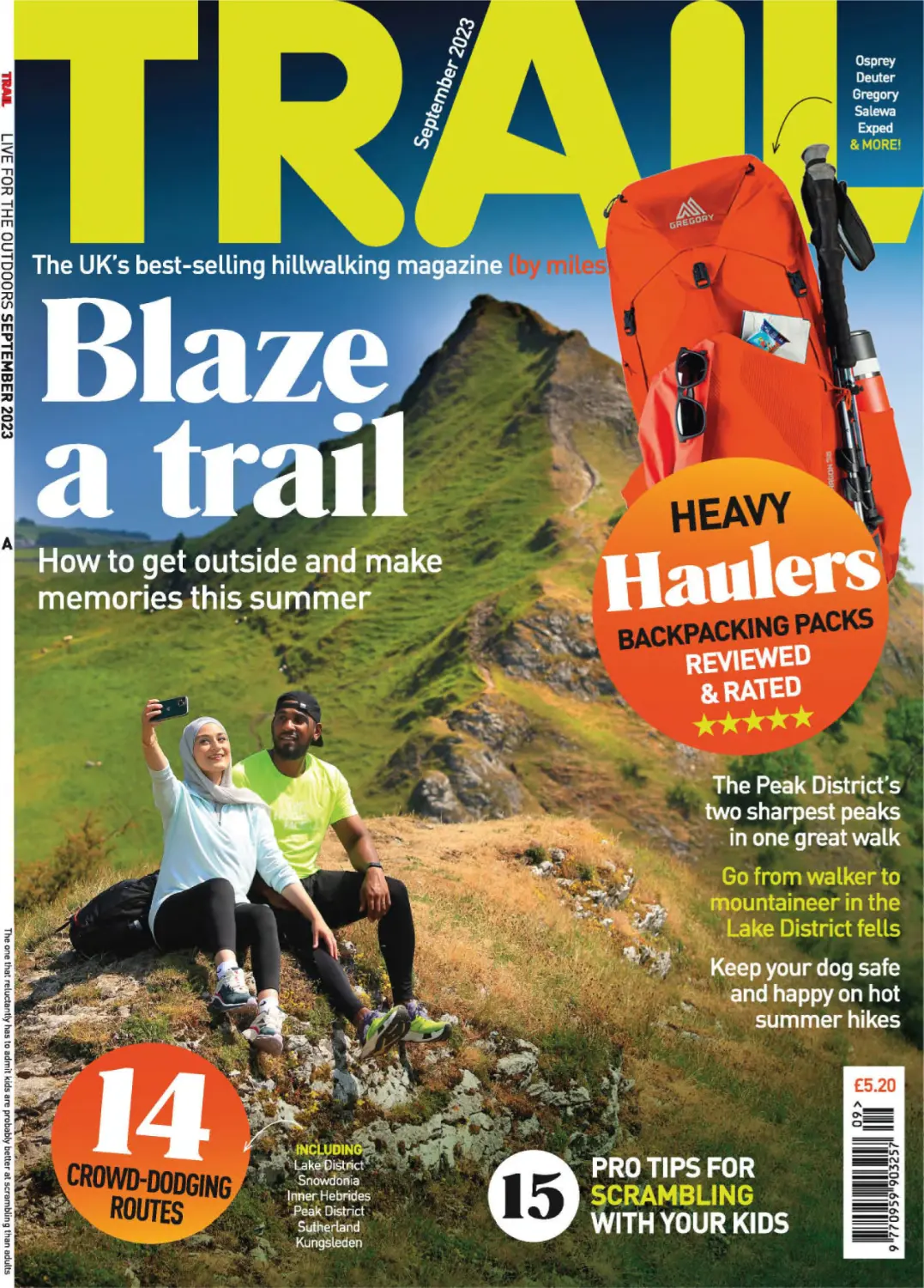
Cover photograph: Parkhouse Hill from Chrome Hill, by Tom Bailey.
EDITOR’S PICKS
Raadia Imran tackles
scorching weather
and an unexpected
dose of exposure
on a classic Peak
District walk p28
Jenna Maryniak takes her
scrambling to the next
level by hiring a guide,
grabbing a rope and
going ‘mountaineering’
in the Lake District p36
Will Legon gives a great
answer to the question
“How the hell do we
entertain the kids this
summer?” Take them
scrambling, of course p44
SEPTEMBER 2023 TRAIL 3
Trail, H Bauer Publishing, Media House,
Lynch Wood, Peterborough, PE2 6EA
Phone 01733 462811
Email trail@bauermedia.co.uk
EDITORIAL
Editor Oli Reed
Deputy editor Jenna Maryniak
Art editor Louise Parker
Production editor Shane Collins
Gear editor Ben Weeks
Editorial assistant Sara Herbert-Mattick
Photographer Tom Bailey
ADVERTISING
Commercial manager Anna Skuse,
anna.skuse@bauermedia.co.uk
Classified sales Chloe Sharpe,
chloe.sharpe@bauermedia.co.uk
MARKETING
Marketing manager Zoe Blanchflower,
zoe.blanchflower@bauermedia.co.uk
Newsstand marketing Samantha Thompson
PRODUCTION
36
Print production Colin Robinson
Ad production leisureads@bauermedia.co.uk
Printers William Gibbons Distribution Frontline
SUBSCRIPTIONS
To contact us about subscription orders, renewals,
missing issues or any other subscriptions queries,
please email bauer@subscription.co.uk or phone
01858 438884 (UK) or +44 1858 438884 (overseas)
DIGITAL ISSUES
From
walker to
mountaineer
Get ready to take
your scrambling
skills to the
next level in the
Lake District.
Email: digitalmagazinesupport@bauermedia.co.uk
BACK ISSUES
To order back issues, please phone 01858 438884
(UK) or +44 1858 438884 (overseas)
H BAUER PUBLISHING
Managing director Steve Prentice
Digital managing director Charlie Calton-Watson
Chief financial officer Bauer Magazine Media
Lisa Hayden
CEO UK Publishing Chris Duncan
Trail is published 13 times a year by H Bauer Publishing.
No part of the magazine may be reproduced in any form in whole or in part, without the prior
permission of H Bauer Publishing. All material published remains the copyright of
H Bauer Publishing and we reserve the right to copy or edit any material submitted to the
magazine without further consent. The submission of material (manuscripts or images etc)
to H Bauer Publishing, whether unsolicited or requested, is taken as permission to publish
that material in the magazine, on the associated website, any apps or social media pages
affiliated to the magazine, and any editions of the magazine published by our licensees
elsewhere in the world.
By submitting any material to us you are confirming that the material is your own original
work or that you have permission from the copyright owner to use the material and to
authorise H Bauer Publishing to use it as described in this paragraph. You also promise that
you have permission from anyone featured or referred to in the submitted material to it being
used by H Bauer Publishing. If H Bauer Publishing receives a claim from a copyright owner or
a person featured in any material you have sent us, we will inform that person that you have
granted us permission to use the relevant material and you will be responsible for paying
any amounts due to the copyright owner or featured person and/or for reimbursing H Bauer
Publishing for any losses it has suffered as a result. Please note, we accept no responsibility
for unsolicited material which is lost or damaged in the post and we do not promise that we
will be able to return any material. Finally, whilst we try to ensure accuracy of your material
when we publish it, we cannot promise to do so. We do not accept any responsibility for any
loss or damage, however caused, resulting from use of the material.
COMPLAINTS: H Bauer Publishing is a member of the Independent Press Standards
Organisation (www.ipso.co.uk) and endeavours to respond to and resolve your concerns
quickly. Our Editorial Complaints Policy (including full details of how to contact us about
editorial complaints and IPSO’s contact details) can be found at
www.bauermediacomplaints.co.uk
SYNDICATION DEPARTMENT: syndication@bauermedia.co.uk
H Bauer Publishing is a company registered in England and Wales with company number
LP003328, registered address Media House, Peterborough Business Park, Lynch Wood,
Peterborough, PE2 6EA. VAT no 918 5617 01
H Bauer Publishing is authorised and regulated by the FCA (Ref No. 845898)
© Bauer 2023
4 TRAIL SEPTEMBER 2023
6
Peak of the Month
Discover Arkle in the far, far north
8
Base Camp
Happenings from high places
12 Out There
Your adventures and summit selfies
14 Mountains for the Mind
Mental health – out in the open
16 Nature notes
Perky birds of the uplands
62 Mountain skills
Top advice from Trail’s experts
64 Masterclass
Expert
scrambling
tips and
tricks
18
28
44
Ben Avon
Join us on an awe-inspiring
expedition to the Highlands
Dragon’s back of
the White Peak
Taming Chrome & Parkhouse
Hill in the Peak District
Scrambling with kids
Enjoy an adventure fit for all
the family this summer
52
58
Accessible
hills
Unlocking
trails for all
Hot Topic
Dive into the
world of wild
swimming
At the top of Middle Fell
Buttress, Langdale.
The view from
Hindscarth – p87.
87
89
91
93
95
97
68 Packs made
in Britain
70 Field Test
Budget
waterproofs
75 Which
sleeping mat?
76 Head to Head
Best
backpacking
rucksacks on test
80 Long-term reviews
Hindscarth & Robinson, Lakes
Dyfi Hills, Eryri (Snowdonia)
Beinn Bheigier & Glas Bheinn, Islay
Lum Edge, Peak District
Longsleddale, Lakes
Western Wainwrights, Lakes
ULTIMATE WEEKENDS
99 Wild Bala, Eryri
103 Sutherland Mountains, N Highlands
Walking in to Arkle –
p104.
LONG-DISTANCE TRAILS
107 King’s Trail (Kungsleden), Sweden
BRITAIN’S GREATEST SCRAMBLES
112 Wildboar Clough, Peak District
SEPTEMBER 2023 TRAIL 5
NORTHERN HIGHLANDS
Arkle
“Arkle? Isn’t that a racehorse?” To save their
blushes, we won’t tell you which member
of the Trail team uttered those words, but
they’re probably not the first person to
demonstrate ignorance of this magnificent
mountain. At 787m Arkle’s not high by
Scottish standards, but there are two key
factors which set it above most hills of its
stature. Firstly, it’s a long, long way away
from nearly everybody on the British Isles. It
sits in Sutherland in the far north of Scotland,
and only a handful of lumps and bumps that
can properly call themselves mountains can
be found further north. Arkle is on an almost
identical (albeit slightly more southerly)
latitude to Ben Hope, the most northern
Munro, and the summits of Ben Loyal,
Foinaven, Cranstakie and Beinn Spionnaidh
are the only other UK mountains that stand
between Arkle and the Arctic Circle. But
it’s the quality of Arkle, rather than simply
its location, that make it such a wonderful
character. It’s a sprawling hill, with steep
crags on nearly all sides, and it’s a bigger
day out than its elevation might lead you to
believe. Arkle’s south-eastern flanks are its
gentlest and most welcoming, climbing to a
central summit on a wide-open plateau with
exceptional views in all directions, including
over to its close neighbour Foinaven. But the
mountain’s true summit sits at the end of a
curling spur of ridge on its north-western
extremity, and from there the views are
possibly even better. It’s a mountain that,
once seen, will be lodged in your memory.
Once climbed, it’ll live in your heart.
WALK IT! Turn to p104 for a full route guide.
6 TRAIL SEPTEMBER 2023
SEPTEMBER 2023 TRAIL 7
VIEW WITH A PUB
WEST ARMS COUNTRY INN,
LLANARMON DYFFRYN-CEIRIOG
Nowhere does country inns like Britain, and hidden away in the
foothills of the Berwyn mountains is this little gem. With fantastic
views to these underrated hills of north Wales, and a gorgeous pub
garden from which to enjoy it when the weather is nice, this is a
great stop for walkers. Inside it is all flagstones, beams and all the
unmistakeable character of a 16th century building. There’s a range of
dog-friendly rooms and some rather nice food on offer too. We’re off
to discover a quieter part of Wales... thewestarms.com
Time to get outside?
Anyone who loves mountains knows that being outside in nature
is good for us. But it seems not everyone has caught on. Forest
Holidays has collated research that shows…
90%
to wildlife in their
everyday lives
of the day is spent
inside (on average)
37%
of people say they
have no connection
47%
say they never
have the time or
opportunity to
get outside
HOWEVER…
85%
agree being in
nature makes
us happy
tinyurl.com/forestmentalhealth
OVERNIGHT PARKING APP
Car camping, campervanning, or just want to leave
the car overnight for a wild camping adventure?
Check out places to park on the app ‘Park4night’.
It’s full of mapped recommendations, reviews,
info and photos of where to park.
8 TRAIL SEPTEMBER 2023
■ READ IT!
Recognise this
chap? You will
if you’ve ever
watched Outlander!
The star of the
Scottish TV series,
Sam Heughan,
has just released
a book about his
personal journey
of walking the
West Highland Way
to much critical
acclaim. Waypoints:
My Scottish Journey
is a love letter to
the wild Scottish
landscape, with
the walk itself a
backdrop for the
story of Sam’s
life. It became an
instant The Sunday
Times and New York
Times bestseller.
Lifesaving advice
With the weather hopefully warming up
nicely, it’s prime time for a spot of wild
swimming. But would you know what to do
if you got into trouble in the water? A recent
study revealed that 32% of Brits wouldn’t.
So the Royal National Lifeboat Institution
(RNLI) and Kärcher have joined forces to
raise awareness of a lifesaving technique
for people experiencing cold water shock,
to relax and control their breathing in a new
‘Float to Live’ campaign…
● Tilt your head back with ears submerged
● Relax and try to breath normally
● Move your hands to help you stay afloat
● It’s ok if your legs sink – we all float
differently
● Spread your arms and legs to improve
your stability
$$
$
$
$
$!
#$ $ $ $
$
$
!$
#$
$"
$
$$ #
$
$
(0
(0)0
+()0&*0%$#)0*.#0'*
)/0#0.*&%'$$0
%&$**
$#00(.*0(%$*0$&0
#0!$+#*#0
#0*& 0&+###0
"
#0%
#0
*0#0!$-#0(* 0
(0
(0-&/*#0.0
#$.0
$,*0
%#0'/0
() 0
#*$0$#0'
#*0 '$+#& 0 $0#/.'0
#0$0#/)#0(0#0*0
#$. 0**0)0*$+0()&)/0$+)&0
),&(0$+'0 &0+' 0.)&0'% #)0!#
#0)0.$#*0 -0
#/0#(*/0! (0
#0)0.
0% (0/$,0 $- 0
$
0 0!+0('00&!++!('0,(0&)0(-,0('0
.
*/0 0
)
#0 0 $$
'
0, ,0+)'+0
(-*0(-',*!
+0 0(
0,
0+0
!'
+,0
"$%+0'
0&(-',!'+0'
00)-'!+ "' 0
&0(
0+
',0 !+0&(', 0
0$((#+0#0('0&(-',!'0)
*
,!('0!'0,
0 #
+0,
'0$&(+,0
%(+
+0 "+0.'0!'0,
0! $'
+0
<02 1=
'= ;.0=
"#
+'=
9L9A*>9&A4:9&7L4EEIL&2L&ILF*L
F&6*L7::6492L&(>:@@L99*>)&7*L
#&77*IL&AL
477&>L:9LA3*L:A3*>L@4)*L:,L
A3*L@3499492L4K&L 4E*? L4&9*L8IL
8:B9A&49L>:'49LA*77@L8*L%:BL&>*L
8IL,&E:B>4A*L&)E*9AB>* L!34@LF&@L3*>L/>@AL9423AL
'4EEI492L&9)L9:A3492L48<>*@@*@LA3*L>423AL649)L:,L
7&)IL8:>*LA3&9L@<*9)492LA3*L9423AL:9L&L8:B9A&49L
A:<L49L&L'4EEIL'&2 L
&I@A&(6@L4@L@:8*LF:B7)L@&ILA3*L'*@AL8:B9A&49L
49L&77L:,L
&6*7&9) L!3*L8&9IL>:(6IL@B884A@L<>:E4)*L
<7*9AJL:,L:<A4:9@L,:>L@3*7A*? LA@L&9L&(34927IL<>*AAIL
8:B9A&49L,C77L:,L'*&BA4,B7LA&>9@L&9)L:.*>@L&9L
*&@IL,B9L@(>&8'7*L*9L>:BA*LA:LA3*LA:< L$*L&>>4E*)L
49LA3*L)&>6L3&)L3:AL):2@L0:8L&L-7&@6L,:>LA*&L&9)L
@&AL2&K492L&ALA3*L49)42:L9423AL@6IL,B77L:,L@A&>@LA3&AL
7::6*)LF4A349L3&9)@L>*&(3 L
9LA3*L8:>9492L7423ALF*L&>*L9:FL*95:I492L4A@L177L
'*&BAILA3*LE4*FL):F9LA:LBAA*>8*>*L4@L*H(*<A4:9&7 L
:B9A&49@L>4@*L49L&77L)4>*(A4:9@ LA@L3*&>AF&>8492L
A:L69:FL&L>*(:>)'>*&6492L L<*:<7*L
'4EE4*)L:BAL:9LA3*L@&8*L9423A L
,A*>L&L7:92L)>4E*LA:L (:A7&9)L
L<&>6LB<LA4>*)L49LA3*L)&>6L
&ALA3*L*9L&F*>@L(&>L
<&>6 LL
B9>:L>*)B(*)L
A:L$&49F>423AL3*423AL
'*(&B@*L:,LA3*L&)E&9(*)L
(&>L<&>6L 8LB<LA3*L
8:B9A&49 L!3*LE&9L@A&>A@L
'B8<492 LLA3496L4A@L
E*>ILF49)IL'BAL(&9AL@**L
:BALA3*LF49):F@ L!3*9L4AL
@A&>A@L>:(6492L&9)L':B9(492 L
A>&92*LLA3496 L!3*9LL>*&74@*L
A3*LE&9L4@L>:77492L'&(6L):F9LA3*L
(34*3&774:9L4@L&L<*>,+(A7IL@I88*A>4(&7L8:B9A&49L@:L
8B(3L@:LA3&AL49LA3*L A3L(*9AB>IL4A@L2>&E4A&A4:9&7L
<B77LF&@LB@*)LA:L(&7(B7&A*LA3*LF*423AL:,LA3*L&>A3L
/E*L@*<A4774:9L949*L3B9)>*)L&9)L@*E*9AJL@*HA4774:9L
647:2>&8@L4,LI:B>*L49A*>*@A*) L :L&':BALA3*L@&8*L
F*423AL&@L4@@@L'&(6<&(6 LL746*LA:L'*L<>*<&>*)L,:>L
*E*>IA3492L@3*L@&I@ L
@LF*L346*LB<LA3*L*&@IL<&A3L&)84>492LA3*L
*H<&9@4E*LE4*F@L49LA34@L,:>2:AA*9L<&>AL:,L (:A7&9)LF*L
3&E*L&L2>*&AL(3&AL>&92492L,>:8L0**LF477LA:L'&)L'*A&L
:9LA3*L':B7)*>492LF&77 L"3*L@D884AL>4)2*L4@L&L7:92L
&9)L@A:9IL':B7)*>L/*7)L>*=B4>492L&AA*9A4:9 L*@<4A*L
A3*L,:>*(&@ALF49)L&9)L@9:FL9:AL&>>4E492LA34@L@A477L
4@9AL&L<7&(*L,;>L&LA*9A L>:<<492L'&(6LL/9)LA3*L
4)*&7L@<:AL:E*>7::6492LA3*L)*@*>A*)L77AL
:>LE&77*I L
&8<492L49L>I>4L:>LA3*L&6*@LI:BL@**LE477&2*L7423A@L
&AL9423AL'BAL49L (:A7&9)L4A@L5B@ALA3*L)&>69*@@L:,L
A3*LE&77*I@ L"3&AL,**7492L:,LA>B*L>*8:A*9*@@L4@LF3&AL
8&6*@L (:A7&9)L*HA>&L@<*(4&7 L
,$$,;= 611=(=
1=
,*=%*14/&=
=
0=+8.=
'
5
:=+"#2
+'=+=5==
=- !0=:.<=
#"; #!.=0+9"="
&=
'=2
.=
#
2
&= 5 .5=<+9.= #"'= 5=
8:B9A&49 LA@L@B))*97ILA*>>4,J492L':B9(492L:E*>L
2>&@@L&9)L@A:9* L
L(&9AL@**L:BAL&9)L):9AL69:FL4,LL&8L2:492LA:L
2:L:E*>L&L(74. L&92L&L@47E*>L'4>(3L'>*&6@ L"3*LE&9L
4@L8&>::9*) LL/9)LAG:L@A>:92L2BI@L7*HL&9)L:*L
F3:L3*7<L<B@3L4AL,>** L *8*8'*>LI:B>L3&9)'>&6*L
9*HALA48*LA3*IL@&I L*9L&F*>@L@B884ALA>42L4@L49L
8B(3LA3*L@&8*L@A&A*L&@L8ILE&9 L!3*LF*&A3*>L3&@L
*&A*9LA3*L(:9(>*A*L&9)L4A@L4>:9L@B<<:>AL'&>@L&>*L
4A@L9*HAL(:B>@* L!3*>*L4@L9:LE4*FLA:)&IL'BAL8L
A3&96,C7LA3&AL9:AL@**492LA3*LE4*FL8*&9@LL&8L@A477L
&74E*LA:L'*L&'7*LA:L9:AL@**L4A L
:)37/=
Schiehallion’s summit ridge
requires attention. But so
does the view.
“Life’s emptiness empties
Itself upon the mountain climb
Replaced with purpose
Fear and excitement
A feeling of living
Is it brilliance or stupidity
That brought us here”
Haystacks has many
rocky summits.
International Bivvy Bag Day on
Haystacks. Join Russ on the summer
Bivvy Bag Day, which takes place on
26 August.
Buttermere from Haystacks.
Tea on Schiehallion.
SEPTEMBER 2023 TRAIL 11
Ben Nevis West Highlands
“Here’s a pic from the summit of Ben Nevis. It was the
first time I’d made it up here and I was totally blown
away. I left at 4am to beat the 28°C heat. Not a bad
first Munro, and my first logged hike working towards
becoming a Mountain Leader. Can’t wait to hike more
of Scotland in the future.” Adam Harris
Cneifion Arête
Snowdonia (Eryri)
“On my first Grade 3 scramble,
the Cneifion Arête. Perfect
summer weather, so swiftly
followed by the Dolmen Ridge.
My guide was Sam from The
Mountaineering Company.
Fantastic day!”
Sara Clark
Pillar Lake District
“Beginning of June and a perfect day
to walk from Wasdale Head, over
Black Sail Pass and on the high-level
route with great views passing Pillar
Rock.” Nat & Sarah Wright
12 TRAIL SEPTEMBER 2023
Old Man of Coniston
Lake District
“My nephew, Gregor Fisken, and his
first ever outing completing the Old
Man Of Coniston.” Paul Heywood
Pavey Ark
Lake District
Trail ran into Stephen
Moore on a glorious day
in the Lakes recently.
Amazingly, he’s on his
60th round of the 214
Wainwrights, having done
his first round in 1971! At
the age of 74, it gives us
all hope that we can be
enjoying the mountains for
many years to come.
Go Stephen!
Pike
of Blisco
Lake District
“I never thought
I’d still be solo wild
camping in my 70s.
But here I am enjoying
mid-June’s 4.53am
sunrise breaking over
the Langdale Pikes
from Pike of Blisco.”
Tom Chapman
Roseberry
Topping North
York Moors
Alex, Linda and John
Parker on North
Yorkshire’s Matterhorn.
Sgurr na Lapaich NW Highlands
Snowdon (Yr Wyddfa) Eryri
“A photo of myself and my mate Mike Trimby
with some mountain-made friends during
horrific rain, fog and winds along the Watkin
Path to the top of Snowdon in June. Epic
first climb and won’t be the last.”
Rob Morison
Longlands
Fell Lake
District
“A very special moment for me at the summit of
Sgurr na Lapaich. After completing the Munros last
year I finally got to show my ‘children’ (L-R: son-inlaw Cain, son Ben and daughters Carly and Hannah)
what it was all about, bagging their first Munro.”
Mark Linnecor
SEND
US YOUR
BEST PIC
Every month the best pic will win a Multimat
mattress worth £135! The Summit 25/38
is tough, light, durable and maximises
comfort in the most extreme conditions.
“Me, boyfriend Stu
and our puppy George
who went in the doggie
backpack when he
got tired, having just
walked Uldale Fells.”
Jo Waller
SEND YOUR PHOTOS TO ‘OUT THERE’: trail@bauermedia.co.uk
FOLLOW TRAIL:
@trailmagazine
facebook.com/trailmagazine
@trailmagazine
SEPTEMBER 2023 TRAIL 13
MOUNTAINS
FOR
THE MIND
O
n 1 July 2023, despite being
treated to a typically less than
ideal dose of north Wales
weather, a group of fundraisers unlike
any other reached the 1085m summit
of Yr Wyddfa (Snowdon). This very
special challenge was organised by the
UK charity Back Up, with the aim of
getting 12 wheelchair users who have
all experienced life-changing spinal
cord injuries up to the summit of Wales’
highest mountain.
The group battled strong winds on a
mountain famed for being the wettest
place in Britain, but we’re delighted to
report that all 12 participants, along
with their teams of friends, family and
supporters, completed the challenge
and have so far raised over £80,000
for Back Up’s vital services.
“I have been utterly terrified of heights
for many years,” said Jo Wright, one of
the successful summiteers. “I also hate
being out of control of my wheelchair,
feeling very vulnerable if others are
dictating my movements. However, I
wanted to raise vital cash for Back Up,
a charity very close to my own heart.
I must confess that there were points
on both the ascent and descent where I
closed my eyes and hoped for the best!
“It was a terrific experience, aided
by a wonderful team from Shoosmiths’
Serious Injury, who have played a key
part of my journey and been fabulous
long-term supporters of Back Up.”
As well as raising much-needed funds
for a charity that offers life-changing
14 TRAIL SEPTEMBER 2023
K BARTELSKI
Mountains for the Mind is a campaign that raises awareness of the amazing benefits
of spending time outdoors for mental and physical health. In every Trail issue we
share stories from people who do inspirational things in the mountains, and none
more so than the 12 wheelchair users who reached the roof of Wales last month.
The Push challenge saw 12
wheelchair users and their
support teams climb Yr Wydffa
via the popular Llanberis Path.
services, The Push challenge proved that
with the right equipment and level of
support, people with spinal cord injuries
can achieve amazing things in the
mountains. Each group member used a
specially customised wheelchair capable
of tackling rocky ground, uneven
terrain and steep steps, allowing them to
travel safely up and down the popular
Llanberis Track.
The youngest participant was Ted, an
eight-year-old from the West Midlands
who approached the challenge with
boundless enthusiasm. And the fastest
person to complete the route was Tina,
in a stunning 2 hours 23 minutes.
“It was an incredible experience,”
said Tina. “The morale, excitement
and determination of every wheelchair
user was fantastic. People can feel lost
when they first sustain a spinal cord
injury. Challenges like The Push show
that anything is possible for wheelchair
users. These kinds of challenges also
allow you to keep your fitness levels up
and improve your wheelchair skills.
“Back Up is so important to me. Since
finding them, it has shown me that I can
still live life to the full with a spinal cord
injury. The courses, events and other
services they provide ensure that you
have the skills to live an independent
life, and offer a safe environment to ask
questions and get support from people
in similar situations.”
For more about The Push, and how
you can donate to this amazing charity,
check out thepush.backuptrust.team T
“PEOPLE CAN
FEEL LOST
WHEN THEY
SUSTAIN A SPINAL
CORD INJURY.
CHALLENGES LIKE THIS SHOW
THAT ANYTHING IS POSSIBLE”
FACEBOOK POST
OF THE MONTH
Ted was the youngest
challenger at just
8 years old!
The success of the challenge
was down to a huge team
effort that included friends,
family and supporters.
“I’ve just come across this page and am
excited to see all your lovely mountain
pictures! I have extreme anxiety about
getting lost on the hills, but also a
huge passion for mountains (especially
Everest!). In June I plucked up the
courage and did my first Munro, Ben
Wyvis, and I did it solo. I am so proud
that I followed my heart and just did it,
and I actually cried at the top. It’s a big
achievement for me. The mountains
bring me so much happiness and joy,
and I spend hours looking at them. I’m
off to Everest Base Camp in 2025 and
dream about it every day. After losing
my brother suddenly last year, I find
comfort in being outdoors. I feel it’s
the thing that keeps me going, and I’m
excited for the next
adventure!”
Sarah
MacDonald
Find out how you can join our 17,500-strong
community and support the cause at
SUPPORTED BY OUR OFFICIAL PARTNERS
SEPTEMBER 2023 TRAIL 15
Perky & punky:
Crested tits and crossbills
WO R D S T O M B A I L E Y
N
ext time you climb up through
the pine forests in the north-east
of Scotland on your way to some
lofty, Cairngorm peak, keep your head
lifted and your eyes open, because these
forests are home to rare and characterful
creatures; birds that, if you catch a glimpse
of them, will brighten your day and
illuminate your way…
The crested tit is probably one of our
perkiest of little birds. Often used as a
poster star by conservation bodies, this
little brown-backed, fawn-bellied tit has an
impressive spiky black and white chequered
crest, straight out of the punk era, that it
holds upright whenever a camera is pointed
in its direction. Or at least that’s how it
seems… With a wingspan of 17-20cm,
they’re about the same size as a blue tit
and are also resident all year round.
The British population is between 1000
and 2000 pairs, and they only occur in
the area of the Spey valley, particularly
in Caledonian pine forests, plantations of
Scots pines and also mixed woods in the
area. Food is mainly insects and their larvae,
which they collect while clinging to tree
trunks. Other foods are pine seeds, berries
and, in the depths of winter, they will even
scavenge fat from the remains of shot deer.
Winter sees them forming up with other
tit species, roaming around the forest in
huge gangs, even occasionally making it
into nearby gardens. The nest is made in a
hole in a tree trunk. A small cup of moss,
lichen, hair, wool, and even spiders’ webs,
creates a comfy mattress for the 4-8 young.
The female excavates the nest and incubates
the eggs, but the male feeds the young for
the first week or two.
If, while in this area of Scotland, you
hear a soft, rattling trill above you, it’s
more than likely a family group of these
charismatic birds. I remember one June
day, in the Rothiemurchus forest, sitting on
a fallen tree trunk, taking it all in, when I
was greeted by a lone crested tit. It came to
within a few feet of me, chattering away,
making my day. Alas, when I got Google
to translate what it was saying, I realised
it wasn’t a greeting but a very firm “Go
away!” Cheeky little blighter…
The same area of Scotland is also home
to all three of our crossbills – large finches
16 TRAIL SEPTEMBER 2023
with a strong bill, crossed at the tip,
especially evolved for feeding on the seeds
of cones. The most common is, simply,
the crossbill (sometimes referred to as the
common crossbill), which occurs quite
widely across the country, but preferably
seeks out spruce forests. The male bird is
red in colour, unmistakably so, while the
female is a greenish brown. Wingspan is
27-30cm, and they’ll be encountered in
the treetops in noisy family groups and
larger flocks. Crossbills are an ‘irruptive’
A DISTINCTIVE SONG ERUPTED – IT WAS A MALE
CROSSBILL, FULL OF THE JOYS OF SPRING,
PROCLAIMING ITS LOVE OF LIFE TO THE WORLD
species, meaning their numbers fluctuate
some years, while an average breeding
population is in the region of 26,000 pairs.
Next is our only endemic example, the
Scottish crossbill. Annoyingly, they’re
super-hard to tell apart from their more
common cousins. Again, the Spey valley
forests are their main domain, the area’s
woods supporting around 6800 pairs.
The last of the three is the parrot
crossbill, and with as few as 65 breeding
pairs you’re going to be lucky to see
one. Winter birds swell the population,
especially when corn harvests have been
poor on the continent. However, with a
keen eye it is possible to tell them apart
from common crossbills. The male is more
of an orangey/red colour and the shape of
the bill differs; in the parrot crossbill it’s
much deeper, quite ugly looking. Combine
that with a strong bullish neck and this bird
exudes a different, less elegant appearance.
That heavy bill is used on Scots pine cones.
A couple of years ago, in the Glen Feshie
area of the Cairngorms, I passed through
a pine forest. High in one of the trees a
distinctive song erupted, one that I didn’t
recognise. A colleague soon told me it was
a male crossbill, full of the joys of spring,
proclaiming its love of life to the world.
Those are the best days – when you see
something special and learn something new. T
Tom Bailey is an outdoor writer, nature expert
and long-serving Trail magazine photographer.
THE PERFECT PINK PATIO PLANT!
“The Lavatera Mallow ‘Barnsley Baby’ produces
pots and pots of flowers for months on end!”
SUPERB
VALUE!
Peter McDermott
Head Gardener & Plant
Expert
NOW ONLY
.97
£9
Now’s
the time
to buy!
PER PACK
+P&P
WHEN YOU BUY 2
FOR JUST £19.94
SAVE £40.00!
T
he Lavatera ‘Barnsley Baby’ has taken
the huge flower power of its vigorous
cousins and focussed it on a much smaller
and naturally compact form. It produces
pots and pots of lovely candyfloss pink
flower displays from the top to bottom of
each stem all summer long and through
to early autumn – returning every year
with even more blooms.
It’s totally hardy and very tough and
robust come rain or shine, and its nectar
pollen-rich flowers will attract bees and
other pollinators to your garden.
‘Barnsley Baby’ Lavatera
3 x 9cm pots
Was £29.97 Now Only £14.97
Or Buy 2 for Just £19.94 – SAVE £40!
0844 502 0050
Calls cost 5p per min plus your network’s access charge.
Corydalis ‘Blue Heron’
NOW £14.97
SAVE £15.00
Offer available while stocks last. © YouGarden Ltd 2023
USE CODE
TRAIL101
DY
R HA
R
TE
www.YouGarden.com/TRAIL101
or by post using coupon below to: Offer TRAIL101 YouGarden, PO Box 1468, Peterborough, PE1 9XL
HALF PRICE SAVE £15.00!
This beautiful and unusual
perennial has so much to
offer. Deep blue-green
divided foliage in neat
clumps give rise to redtinged stems bearing simply
stunning electric blue
tubular flowers with white
throats from late spring until
mid-summer. What’s more,
the flowers are wonderfully
scented! Supplied as 3
jumbo plugs. ITEM: 480809
ORDER TODAY TO AVOID DISAPPOINTMENT!
AL
TOT LY
N
3 EASY WAYS
TO ORDER NOW!
Easy to grow!
WI
Summer long displays every year
More flowers over a longer period
than any other variety
Compact, yet more incredibly
floriferous
Easy to grow and maintain
The perfect plant for your patio
PLEASE SEND TO:
Offer TRAIL101, YouGarden, PO Box 1468, YOUR PAYMENT DETAILS I enclose a cheque/Postal Order payable to
YouGarden (name & address on back) for £
Peterborough, PE1 9XL Or charge my Visa / Mastercard:
YOUR ORDER DETAILS
Item
510339
Description
Price
1 x Lavatera Mallow ‘Barnsley Baby’
3 x 9cm Pots HALF PRICE! SAVE £15!
£14.97
2 x Lavatera Mallow ‘Barnsley Baby’
6 x 9cm Pots SAVE £40!
£19.94
Qty Subtotal
Card
No.
Start
Date
Issue
No.
Exp
Date
DELIVERY DETAILS
These SPECIAL OFFERS go perfectly with your Lavatera:
480809 Corydalis ‘Blue Heron’ SAVE £15!
£14.97
100062 Blooming Fast Superior Feed 500g SAVE £3!
£9.99
Initial
My DOUBLE GUARANTEE to you!
£6.99
Surname
Postcode
Email
Tel
100107 Blooming Fast Plant Treatment £1 PER ORDER! £1.00
Offer subject to availability and in the event that this offer is oversubscribed,
we reserve the right to send suitable substitutes. Despatched from late Add P&P
August. Delivery to UK only and a £6.00 surcharge will apply to the
following postcode areas: AB, DD8-11, GY, HS, IM, IV, JE, KA27-28, KW, TOTAL
PA20-80, PH19-50, TR21-25 & ZE. See website for full terms & conditions. ORDER
Following Brexit there are a number of changes that prevent us from VALUE
trading in N. Ireland. For further details please visit www.yougarden.com
Mr/Mrs/Ms/Miss
Address
1 If you’re not totally happy with your order, return it
within 30 days and we’ll replace or refund in full.
2 Should any hardy plants fail to thrive thereafter,
we’ll replace free of charge. You just pay the P&P.
If you do not wish to receive catalogues & offers
from us, please tick here . We think you’d enjoy
some of the latest products and selected offers
by post from other trusted retailers, charities,
finance, travel, FMCG and utility companies. If you
do not wish to receive these, please tick here .
Full details at YouGarden.com/Privacy.
Peter McDermott,
Head Gardener
AD CODE TRAIL101
CAIRNGORMS
The oddly named ‘The Sneck’ between
Beinn a Bhuird and Ben Avon.
But who made those strange lines?
Aliens? A zen master with a rake?
Or was it the wind? We may never
know (but can probably guess).
18 TRAIL SEPTEMBER 2023
You don't climb BEN AVON by accident. It’s not on the way anywhere,
nor easily confused with another peak. Reaching its summit is
a deliberate act, and one that requires some planning.
WORDS BEN WEEKS PHOTOGRAPHY TOM BAILEY
SEPTEMBER 2023 TRAIL 19
The Punch Bowl at Linn
of Quoich near Braemar
– such a delightful spot
we nearly never left.
20 TRAIL SEPTEMBER 2023
CAIRNGORMS
y introduction
to the mountains
came courtesy of
high school field
trips to Eryri
(Snowdonia)and
the Isle of Arran.
Except, they
weren’t called
‘field trips’; they were ‘expeditions’.
This might have been a ploy to make
them sound more enticing to kids raised
on 1980s action and adventure films,
but to us they felt like expeditions. We
were heading somewhere unknown (to
us anyway), unsure of what we’d find.
There would be adventures.
It was with this in mind that plans
were formed to explore Ben Avon. It
might not be of Everest proportions, or
home to an undiscovered mountain city
like Machu Picchu, and I was fairly sure
that one or two people might have been
there before us. But the important thing
was I’d never been there. I knew precious
little about it and our plans were loose
enough to be able to react to what we
found. It would be a voyage of discovery,
an adventure of exploration. It would be
an expedition.
Vicious wee beasties
All serious adventurers need a sidekick;
Indiana Jones had Short Round,
Tintin had Snowy the dog, Dora the
Explorer had Boots the monkey. I
had photographer Tom. Like most
expeditions, this one would begin in
relative civilisation. We started our
journey from the Linn of Quoich just
west of Braemar, and almost immediately
faced something that had the potential
to derail the expedition. The wood-sided
valley that leads towards the mountains
is one of the most impossibly beautiful
river valleys I’ve ever seen. With its
dappled shade, tranquil falls, and
unusual features (including The Punch
Bowl, a delightfully rounded waterfilled hollow), the lower reaches of Glen
Quoich were so idyllic we considered
abandoning all plans of climbing Ben
Avon and remaining by the watersculpted stepped-rock banks of the
burn instead.
With effort akin to Ulysses’ resistance
of the sirens, we dragged ourselves
away onto the heather-covered hills. A
man came sauntering down the track,
binoculars around his neck and a
harried look upon his features. “Are you
heading up?” he asked pointing behind
Flat, tent-sized spots
are hard to find. We
did our best, but were
glad it didn’t rain.
him. “Watch out for the hen harriers.
They don’t seem to like visitors.” As
it happened, we only saw one raptor
in the distance, and didn’t suffer the
divebombing defence our binoculared
friend had warned us about. The land
around Glen Quoich is part of the Mar
Lodge Estate. It’s an important wildlife
conservation area, owned and managed
by the National Trust for Scotland, which
had no doubt helped the nesting hen
harriers avoid being shot or poisoned.
Glen Quoich heads north-west before
looping north then east around the minor
(by Scottish standards) hills of Carn Elrig
Beag and Carn Elrig Mor. There, south
of Beinn a’ Bhuird, it turns north-east,
then north. It’s like a dot-less question
mark rotated through 180°. We cut the
loop by heading directly north over the
hills. It was tough going, a mixture of
snagging heather and ankle-swallowing
bog, and probably no quicker than the
track alongside the river would have
been. But that’s what exploring is all
about, right? And it did give us great
views into the wooded mid-reaches of the
glen. We dropped to the river beyond the
native trees, looking for a camp. A wild
camp should always be an essential part
of a good expedition, don’t you think?
Hotels are for holidays and Bear Grylls.
Real adventurers do it under canvas. Or,
more accurately in 2023, nylon. After
some hunting, we found the only two
tent-sized patches of dry, flat ground
in a two-mile radius and pitched, with
plans of drinking hot chocolate by the
river as the stars pinged into existence
above. Instead, the wind dropped, and
the swarms arrived. The best laid plans
of midges and men…
Rolling the
weather dice
Unlike serious expeditions, where the
wrong sort of weather can kill you, the
damp grey skies we awoke to were a
disappointment rather than a disaster.
Better weather was due to roll in later,
but there was no accurate timetable for
its arrival. This gave us a decision to
make. Should we sit out the morning
gloom in our tents in the hope that, when
the sun appeared, we’d still have enough
time to get up to Ben Avon’s summit? Or
should we head directly up then, keeping
our fingers crossed that we wouldn’t
have to linger for too long on the top
for the clouds to blow through and for
Tom to get those all-important ‘summit
in sunshine’ shots? Or should we take
the long way up, bagging neighbouring
Munro Beinn a’ Bhuird on the way and
trusting the weather gods to organise
things in our favour?
As with all great adventures, there was
some discussion, debate and, if we’re
honest, disagreement about what to do.
But a decision was reached. We left the
tents, and headed for Carn Fiaclach, the
long spur of mountain that leads from
❯
Glen Quoich up to Beinn a’ Bhuird’s
SEPTEMBER 2023 TRAIL 21
southern top. The dice had been cast; we’d just have to wait and
see how they landed.
As we climbed, the clag lifted, but clung stubbornly to the high
tops. It was beginning to feel like we might have rolled snake eyes.
But as we made our way from the South Top to Beinn a’ Bhuird’s
North Top summit, a 1197m high-point on a rocky plateau,
the cloud thinned, revealing the scalloped eastern edge of the
mountain. In typical Cairngorm fashion, one side of the mountain
plunged in steep, dark crags to lochan-filled corries below. It looked
like we might be about to luck-out, and those weather dice would
settle on that ever-reliable score of seven. But that didn’t happen.
As we neared the top, high above Coire nan Clach, the last of the
clag dissolved altogether, leaving us with blue skies striped by high
wisps of white. We’d landed a double six.
Sergio McLeone
Beinn a’ Bhuird is a big, sprawling hill. It’s nearly two-and-a-half
kilometres from its South Top to its North Top summit, and then
another two-and-a-half kilometres from the summit to The Sneck,
the narrow saddle that joins Beinn a’ Bhuird to Ben Avon. In poor
weather, it would require focussed navigation. In glorious clear
sunshine, we headed for the obvious knoll of Cnap a’ Chleirich, ❯
22 TRAIL SEPTEMBER 2023
CAIRNGORMS
WE HEAR YOU...
The first thing to know about
Ben Avon is that it’s not
pronounced Ben Avon. Say ‘been
ahrn’ and you’re closer to the
mark. It comes from the Scottish
Gaelic Beinn Athfhinn, meaning
‘mountain of the Avon’. The
Avon in this case is the river that
flows from Loch Avon, situated
between Cairn Gorm and Ben
Macdui, to join the River Spey
near Cragganmore, just north of
the Cairngorms National Park.
Looking over to the lumpen
tors of Ben Avon from high on
the plateau of Beinn a’ Bhuird,
the landscape is open, wild
and missing a saloon.
SEPTEMBER 2023 TRAIL 23
Wild pansy below Ben Avon.
picking up the clear path that dropped
from there to The Sneck.
The Sneck is a bealach. In Wales, it’d
be a bwlch. You could call it a saddle,
or a col. But this is a strange one. To the
south, a path dropped gradually into
Glen Quoich. To the north, the ground
dropped steeply into the corrie at the
head of Slochd Mor. Ahead, to the east,
our path climbed upwards towards the
summit of Ben Avon. And all around
were unusual, rounded granite shapes.
Carved by the wind that whips through
this gap in the hills, the boulders had
been rounded and sculpted into various
shapes, including one pile of rocks
which bore a resemblance to a huge
stone throne. Wind-blown patterns in
the pink gravel looked like the rakings
of a zen master in a Japanese karesansui
garden. It was all most unusual. But then,
From left to right: The
tors of Leabaidh an
Daimh Bhuidhe (Ben
Avon’s summit), an
unnamed outcrop, and
Clach Choutsaich, all
worthy of a clamber.
24 TRAIL SEPTEMBER 2023
unusual was becoming the norm.
The high plateau mountains of
Beinn a’ Bhuird and Ben Avon
are unusual. They don’t feel like
mountains. Their tops are vast,
sprawling seas of grass and pink
granite, the latter often broken
down to carpets of gravel, giving
these tops an appearance more
comparable to the great American
plains than any pointy-topped peaks.
Had filmmaker Sergio Leone been
Scottish rather than Italian, we could
have had a whole genre of films known
as Haggis Westerns. As my boots
crunched across the stones, I pulled my
hat lower to shield my eyes from the sun,
and Ennio Morricone’s The Good, the
Bad and the Ugly played in my head.
Like Helm Crag in the Lake District,
or its southern Scottish cousin Ben
Arthur (The Cobbler to its friends) in
the Arrochar Alps, reaching the actual
highest point of Ben Avon requires a little
scrambling. The summit of Ben Avon
has its own name: Leabaidh an Daimh
Bhuidhe (bed of the yellow stag). It sits
like a small bobble on the top of a vast
beanie. Except it’s not all that small
close up. It’s a significant granite tor, a
jumble of wind-rounded rock. Getting to
the top of it is an easy scramble though.
The routes are obvious, and the rock
is exceptionally grippy. Somewhere on
the top of this conglomerate of almost
liquid-like shapes I was treated to a
demonstration of erosion in action. In
a small bowl-shaped recess in the stone,
a puddle of water was being whipped
around and around by the wind, carrying
grains of granite with it as it spun. It was
mesmerising.
Field of bones
Ben Avon features several tors, and
while only one can be the summit, all are
fascinating and worth a cheeky scramble.
Most of them have names too. One of
them looked like an abstract sculpture of
a pile of elephants, while another seemed
to change appearance with every step
towards it and proved to be a trickier
ascent up close. All are made from the
same granite rock that proved to be
exfoliating in all the wrong places.
When we ran out of summit to
explore, it was time to leave the
mountain. Accompanied by a pair of
golden eagles effortlessly riding the
thermals over the glen, we descended
directly towards the narrow wild valley
that carries the River Gairn out of
the mountains. For the most part this
involved steep, pathless slope-trotting
through heather, over grass, and down
occasional scree. But then something
stopped us in our tracks. A dark, almost
black clearing on the ground. The earth
cracking. Pale white skeletal shapes
reaching out from their tombs… A patch
of mountainside had lost its covering
of vegetation. With this gone, the
peat below was gradually
being eroded. And as the
top layers of this dark
earth were being
CAIRNGORMS
peeled away, so the long-dead remnants
of the trees that once grew here were
being exposed, the skeletal remains of
Scots pine left to bleach in the sun.
We took care making our way towards
the path that snaked through the near
perfectly U-shaped glen; the undergrowth
was decidedly ‘addery’. As it neared its
junction with Glen Quoich, the path
climbed as the valley flanks closed in,
rising to a narrow pass beside a small
pool. Then, as the path began to descend,
the glen opened wide. We dropped into
it beside the barely recognisable ruins
of a small building and followed the
trail west back towards our campsite.
Soon, the two small dots of red in the
distance, their comparative minusculity
rendering them almost invisible in the
huge landscape, indicated that we were
nearing base camp. We made plans –
a cup of tea and a flapjack lay ahead.
Home time
and headwear
Tea drunk, flapjacks devoured, and
stoves and tents packed away, we headed
for home. As I walked out, I mulled the
word ‘expedition’ over in my head. It’s
a big word, it can mean big things. But,
in truth, anyone is capable of having
their own expedition. All you need is a
goal, and a plan, and the willingness to
make changes to that plan to achieve
the goal. Ideally, it should involve a
destination that’s new to you, and
enough time to allow a proper adventure
to unfold. Oh, and if you really want to
make it a proper adventure expedition
you need two more things: a plucky
sidekick and a good hat. T
WHAT’S IN
A NAME?
The River Avon takes its
name from the Gaelic
abhainn. If it sounds familiar,
that could be because there
are no fewer than nine rivers
which go by the name of
Avon situated within Great
Britain: five in England,
three in Scotland, and one in
Wales (although the Welsh
one is an anglicised version
of Afan, so, strictly speaking,
doesn’t really count).
The Scottish Gaelic
word abhainn, along with
the Welsh word afon, are
believed to come from the
Celtic Brythonic word abona,
which means river. As such,
the River Avon translates as
the River River, putting it up
there with Lake Windermere
and Torpenhow Hill in the
most famous (if not entirely
accurate) tautological place
names in the UK.
SEPTEMBER 2023 TRAIL 25
Get more of what you
love with a Trail Membership
Join today 01858 438884
Quote TPAA
Terms & conditions: The 3 for £10 trial offer applies to a Print & Digital Package Membership on a monthly recurring basis and will auto-renew to £5.20 after the
initial 3 months. Direct Debit payments will continue to be taken unless you tell us otherwise. Print editions will start with the next available issue. Offer closes
01/10/23 and cannot be used in conjunction with any other offer. Cost from landlines for 01 numbers per minute is (approx) 2p to 10p. Cost from mobiles per minute
PRINT & DIGITAL MEMBERSHIP
3 issues for £10, then £5.20 every
month by recurring payment
Includes:
■ 3 print issues delivered free to your door (UK only)
■ Digital edition access via Member-only app and website
■ Past issues archive and selected audio articles
■ Members-only Rewards, discounts and prizes
■ Monthly editor’s e-newsletter
greatmagazines.co.uk/trail
Scan on your smartphone
(approx) 10p to 40p, but varies depending on the geographical location. You may get free calls to some numbers as part of your call package – please check with
your phone provider. Order lines open 8am-9.30pm (Mon-Fri), 8am-4pm (Sat). Calls may be monitored or recorded for training purposes. For general terms and
conditions, please visit greatmagazines.co.uk/offer-terms-and-conditions
PEAK DISTRICT
28 TRAIL SEPTEMBER 2023
Climbing the narrow west
ridge of Parkhouse Hill,
with Chrome Hill behind.
TAMING THE
Lurking among the green folds of the White Peak
are a pair of spiny summits that look like they’ve
spilled from the pages of a fantasy novel. Are they
as fierce as they look? Raadia Imran chose a
perfect summer day to find the answers.
WORDS RAADIA IMRAN
PHOTOGRAPHY TOM BAILEY
SEPTEMBER 2023 TRAIL 29
“ALTHOUGH PARKHOUSE HILL
APPEARED LIKE A COMPLICATED
& DANGEROUS SCRAMBLE,
IT FELT LIKE JUST THE RIGHT
LEVEL OF CHALLENGE”
30 TRAIL SEPTEMBER 2023
PEAK DISTRICT
Scrambling up Parkhouse
– quite the challenge when
you’re 21 weeks pregnant.
e’d picked a perfect June
afternoon; the sky was clear, and
the sun was shining. My husband,
Shahid, and I pulled into the small
lay-by parking area in the village
of Hollingsclough. I stretched
my arms out wide as I got out of the car and
exhaled deeply, almost like greeting the view
ahead with a giant hug.
I pointed out to Shahid the unique, jagged
faces of the two hills we were set to climb.
The landscape was impressive. He was busy
changing into his hiking trainers, a little
disgruntled from the 2-hour drive in the sticky
heat. I, on the other hand, had quite happily
slipped in and out of a sun-induced snooze
throughout the duration of our journey.
I lay my hand on the curve of my belly,
a little apprehensive for the hike ahead. At
21 weeks pregnant, my bump had only just
started to become visible, and I was starting
to feel tiny nudges and flutters from the
growing baby inside me. The arrival of the
baby was feeling very real and exciting now.
I didn’t know if I was going to struggle with
the hike, but reassuringly my pregnancy
had been a healthy and active one so far. I
was also comforted by the fact that today’s
adventure would be a short one. So, I sipped
my water and reminded myself to be positive
and to maintain a can-do attitude for the day.
Mindset is everything!
The Stegosaurus tail
Looking up at the first hill – Parkhouse
– I couldn’t help but wonder how such a
spectacular looking hill had received such a
plain, unassuming name. Parkhouse sounded
more like the name of a local primary school,
not really a fitting title for this wondrous,
spiky ascent. As we began the first leg of our
❯
circular route, I got a closer look at those
SEPTEMBER 2023 TRAIL 31
“THE DRAMA
OF CLIMBING A
LARGER MOUNTAIN,
CONDENSED INTO A
SMALLER PACKAGE”
knife-thin, pointed ridges. The face of
Parkhouse Hill reminded me of the
serrated blades of a Stegosaurus tail,
cutting menacingly through the silent
green of the surrounding fields.
From the rolling pastures below, my
gaze followed the castellated ridge of
Parkhouse all the way across to Chrome
Hill, a proud and inflated mound of
land. These hills are often referred to
as a ‘Dragon’s Back’, and they certainly
did elicit images of a slumbering, mosscovered dragon resting among the idyllic
landscape of the White Peak.
I was excited to get to the top of
both hills. At this point, I envisioned
myself teetering haphazardly atop the
first limestone-littered summit, trying
desperately to maintain my balance on
a razor-thin point. An intrusive thought
that, fortunately, proved not to be the
case. Although Parkhouse Hill appeared
like a complicated and rather dangerous
scramble, it in fact felt like just the right
level of challenge.
Feeling the heat
Our ascent was a short one, but it didn’t
disappoint. It felt like all the drama and
32 TRAIL SEPTEMBER 2023
excitement of climbing a larger mountain
condensed into a smaller package. This
was perfect for me. The weather was
scorching, and I knew a full day under
the sun would be too much physical
exertion. Instead, the Dragon’s Back
was my magical answer to getting an
outdoor fix without the need for endless,
hot hours on foot. It took us just under
20 minutes to reach the top, with Shahid
carefully shadowing me from behind, just
in case I stumbled.
There’s no fixed pathway or trail to the
top, so the upward journey is a careful
choice of personal route selection. A skill
which, on the day, I was rather proud
of myself for exhibiting. My footing and
general balance felt steady and reliable,
despite carrying extra, precious cargo.
The bouncy, grippy sole of my trail
running shoes also probably had a role
to play in my confidence. I slowly picked
through the white limestone beneath
us, taking pauses and sensible breathers
when needed.
The rocks on Parkhouse Hill are loose,
and a misplaced footing could easily
cause a trip. On a rainy day, this rocky
ascent must get quite slippery, so it’s
probably not the safest route to plan
for in wet conditions. Our entire day,
however, was basked in a hazy glow of
sunshine and once at the summit I basked
proudly in the sun, admiring the light it
cast over the endless green of the land
below. The surrounding fields are divided
quaintly by low grey stone walls, like
a patchwork quilt in various shades of
emerald, jade, and forest green. A quilt
fit for the sleeping dragon we’d just
climbed to the top of
From the summit of Parkhouse, we got
a spectacular view of Chrome Hill. We
were also now starting to feel the burn
of the midday heat, so we kept things
moving quickly. But not before taking
one or two (well, nine to be exact!)
summit selfies to document the feat for
posterity.
The descent was short but steep, so we
carefully picked out our foot placements
until we reached the more even ground of
a sheep-trod, which snaked downwards
and led us back to level ground. My legs
at this point welcomed the flat ground
beneath my feet and I felt my muscles
relax... but not for long. We still had
Chrome Hill to climb.
PEAK DISTRICT
Chrome Hill and Parkhouse Hill are
the remains of ‘reef knolls’, thought
to have been formed over 300 million
years ago when the Peak District
was covered by a tropical sea.
BUXTON
A6
15
A5
Throughout the journey, the local
sheep felt like companions and added
character and charm to the walk.
The loud bleating of lambs and
their freshly shorn mothers further
immersed us in a bubble of nature. We
were fortunate to have the hills mainly
to ourselves, and felt far away from
the constant buzz of city life. For the
most part we didn’t see another soul.
This added to the magic of the
day and allowed me to fully benefit
from the healing qualities of being
outdoors. I’m a strong believer in the
peace that can be achieved by simply
existing against the quiet backdrop
of a green landscape and blue skies.
It’s a sure way to put things into
perspective: the magnitude of the
world vs the small space we occupy
in it all. You can immediately zone
out of your problems and insecurities
and tune into a higher and larger
existence.
But there wasn’t too much time
to ponder deeply. As we began our
upward climb of Chrome Hill, my
legs were beginning to ache. My
baby bump was also beginning to
feel heavy, and the muscles in my
legs were begging me to sit down.
Chrome Hill is a larger hill to climb
than Parkhouse, but nowhere near as
steep. There’s a steady incline and the
40-minute ascent showed me that I
need to choose the stairs more often!
I was breathless but happy as I
reminded myself to stop looking at my
feet, and to take in my surroundings
as I walked. Simply being mindful of
looking up and looking around has
helped me many a time to squash
that self-defeating feeling of ‘let’s stop
now’ or ‘I’ve had enough’.
We could see the summit on our
approach and my husband joked, “I’ll
race you to the top!” I attempted to
run but failed quite miserably, my
legs only allowing me to jog quite
pathetically for a few metres. Shahid
looked back and laughed. “I am
pregnant!” I cried back in defence. I
was also fatigued, hot and hungry at
this point – not the best combination
for a lady in her second trimester.
❯
I was quite diligent about keeping
A53
Nature therapy
Hollins
Hill
Chrome
Hill
HOLLINSCLOUGH
Parkhouse
Hill
SEPTEMBER 2023 TRAIL 33
Exploring the rocky
features while dropping
down the western ridge
of Chrome Hill.
hydrated during the walk though. I
didn’t want to experience sunstroke or
headaches, and the regular water breaks
meant that, despite the heat beating
down upon us, I still felt energised.
Lunch with a view
Once at the top, we settled down with
our tuna sandwiches and marvelled at the
views across the White Peak. It reminded
me of a post I’d come across on social
media, captioned ‘The real reason we go
hiking? So, we can eat our lunch in cool
places’. That feeling, during those few
minutes as you refuel after reaching a
breathtaking location, is unmatched.
After our lunch break, we weighed
up choosing either the easier option
of simply walking back down the way
we’d come up Chrome Hill, or the more
adventurous option of a circular route
which would lead us over the other side
of the hill and through the green pastures
to the village. My earlier fatigue had
faded, and with my stomach satisfied and
a renewed sense of energy we chose the
longer route. It was only 2pm and I had a
desire to be outdoors a little while longer.
We came across a very cool rock
formation on our way down Chrome
34 TRAIL SEPTEMBER 2023
Hill. There was a perfect square archway
in the face of the hill, one you could both
walk over like a bridge and walk under.
It looked like something that belonged in
an enchanted woodland. I unashamedly
asked Shahid to snap some pictures of
me posing under it, showing him first, of
course, the right angle: one which would
display both the clear blue skies and the
lush greenery around me. This was the
perfect ‘Insta-worthy’ spot!
The walk down wasn’t too difficult.
There were some occasional tricky, rocky
patches to navigate and moments where
it did feel quite steep, which is where
a hiking husband to lean on becomes
quite handy. It was a welcome challenge
however, and one that always felt doable,
followed by a stroll through fields that
allowed us to both breathe deeply and
take in the nature around us.
We’ll be back…
On our approach back to the village,
all I could think about was a seat in the
shade with an ice cream in my hand.
I shared this dietary desire with Shahid
and, as is common knowledge, you must
fulfil a pregnant woman’s craving as soon
as possible, or face her wrath! As we
reached the car, we asked some fellow
walkers where they got their little tubs
of ice cream, and they directed us down
to the village.
We heaved into the car, hot and
tired, and drove a little way down to
Hollingsclough Honesty Shop. I loved the
concept of this adorable wooden shed of
a tuck-shop; it was filled with all kinds
of yummy treats and a coffee machine
that you help yourself to and pay for
‘honestly’. There is also a card reader
available, so we were able to use our
phones to pay.
I sat on a picnic bench outside the
shop, scooping spoonfuls of salted
caramel goodness into my mouth
while looking out at the most amazing
view. Sitting here, there is a perfectly
unobstructed view of Parkhouse Hill.
I rubbed my belly and whispered,
“well done” proudly to myself and the
baby – together we had conquered the
Dragon’s Back. It felt like a glorious
accomplishment.
I felt alive and happy. I shared with
Shahid that one day we would come back
here with the baby and share this special
wonder of the Peak District. A hike that
can, and should, be experienced by all. T
%
%%
%%# % %
# % %
% "
%
% %
% %
" % % %
%
% %
% %
%
"!%%
% %
$% %
%
%
1%'*
1 1 /1
10
&1.%"#)1*%&1
1%'*
1
1,#1.%"#)1+
*)1
1%'*
1
1*
-1 #,(
)1
,+,( *1.%"$)1
*(
1(,##
#1)
%)1
1%'*
1
+'
*1+1
1%(+1
1',##
#1*
+)1
1%(+1
1
"
*!))1',##
#1
)
%(*)1
1%(+1 1
1!))
1&1
LAKE DISTRICT
What do you do once you’re confidently scrambling and ready
for the next challenge? To find out, we head to the crags of
the Lake District for a crash course in MOUNTAINEERING.
WORDS JENNA MARYNIAK PHOTOGRAPHY TOM BAILEY
rib Goch. Tick. Striding Edge. Tick.
Tryfan, Sharp Edge, Jack’s Rake. Tick,
tick, tick! With a good number of the
classic Grade 1 scrambles under my
boots, I had two choices. Give myself
a good ol’ pat on the back and bask in
the glories of the past, or set my eyes on the
next frontier – one with bigger exposure and
more technicality. One that required a rope.
Anyone who knows the joys of mountain
walking knows the buzz of getting hands on
rock, of feeling the airiness of a slender ridge.
It’s a challenge, an achievement and it’s kind
of addictive. Maybe it’s because we spend so
much time stuck inside, living too much of life
vicariously through screens, that we need the
thrill of adventure to feel alive. We evolved to
spend our days outside, as part of nature, living
on the edge of survival with risks at every turn.
My hunter-gatherer self, however, had clearly
become a bit of a wuss in the safety of modern
society. The journey to confident scrambling
had not been smooth, and had, along the way,
required the assistance of several mountain
guides and a ‘fear of heights’ course. But the
weather for each of those classic Grade 1s
was in unbelievably perfect, calm, blue-sky
conditions. I took it as a sign.
The next step
For the next phase on the mountain journey,
people talked about The Cuillin Ridge, the
Aonach Eagach, An Teallach… Scottish routes
that sent shivers up my spine, and ones where
I would need a few more skills under my belt.
That’s when I came across Mark Eddy and his
Introduction to Mountaineering course.
In my younger, braver days, I had done a bit
of climbing, mostly on an indoor wall but also
a few rock routes. What I needed, though, was
not a course in climbing up and down a pitch
on a top rope, but skills in moving quickly
and efficiently through more tricky mountain
terrain. I needed to test my abilities on harder
routes, but also get that buzz of pushing at my
comfort zone and achieving something new.
“On belay”
The Lake District is full of harder routes that
mere mortals like me have never heard of,
36 TRAIL SEPTEMBER 2023
and instructor Mark had picked Middle Fell
Buttress on Raven Crag as our training ground.
From the back of the Old Dungeon Ghyll car
park deep in the Langdale Valley, Raven Crag
rose up imposingly, leaving no doubt as to its
verticality. Eeek.
Mark had all the gear, and I was a bit
worried I had no idea, as we headed up to the
base of the crag. He’d brought more than we
would usually need for a mountaineering route
to enable me to experience the full range of
tools at my disposal. We’d planned an actionpacked 5-pitch ascent, which meant climbing
the route in five sections, with an abseil and a
bit of scrambling to finish.
Helmets on to protect from any falling rock
from above, Mark set up a belay. For the first
pitch this basically involved me being attached
to Mark by a rope and a belay plate. He would
lead the climb up, placing gear (nuts and cams)
into the rock and attaching his rope to it as
he went. If he fell, it was my job to hang onto
the rope as if his life depended on it (it would)
and hope that the gear he’d put into the rock
held firm. In climbing and mountaineering this
is the main way of protecting the lead climber
from falls in any difficult sections. I would then
follow Mark up the climb, taking the gear out
of the rock as I went.
Our climb was graded a ‘Diff’, which is
basically an easy rock climb and the next grade
up from a Grade 3 scramble. So, as the bright
orange pair of legs disappeared up the crag
with no hint of really needing me on the other
end of the rope, I contemplated the ominous
fact that it was me next.
“Climbing!”
With Mark having led the climb, and now fixed
on a ledge some 20m or so above me, I was on
a top rope. If I fell, there would be no chance
of a big drop or swing, as I was being belayed
from above. I took a few steadying deep
breaths and grabbed hold of the rock. Mark
had made it look so easy, but the hand and foot
holds suddenly seemed a lot smaller than what
I was used to on scrambles.
My head was buzzing, and as I clambered
with a lot less composure than I’d intended,
❯
a nut pinged out of the rock. I realised I’d
SEPTEMBER 2023 TRAIL 37
LAKE DISTRICT
WHAT KNOTS
DO I NEED?
Figure of eight – used to tie the
rope to your harness
Italian hitch – can be used to
belay a climber or used for
abseiling
Clove hitch – used to attach a
climbing rope to anchors
WHAT DO I SAY?
Comms is very important
to keep you safe when
mountaineering. Here are a few
of the climbing lingo basics:
“On belay climb when ready” –
I’m holding the rope and ready
for you to climb.
“Climbing” – I’m about to set
off climbing.
“Safe” – I’ve got to the top and
you can take me off belay.
“Take in” – Tight rope please!
“Slack” – Let the rope out
a little.
“Below!” – Watch out! There’s
something falling your way
(rock/rope etc).
38 TRAIL SEPTEMBER 2023
forgotten to do my one job, which was to take out
the gear and clip it to my harness as I went up.
I had a quiet word with myself, and realised my legs
were trembling. ‘Disco legs’ or ‘Elvis legs’ they call it.
Not quite enough for anyone to notice, but still,
I knew the adrenaline was pumping through me by
the bucketload.
Reminding myself to take my time and trust my
feet, before I knew it I was met with Mark’s grinning
face on a pleasingly large ledge at the top of the first
pitch. The last few moves had gone in a complete
blur, but it had started to feel easier as I’d steadied my
nerves and got a grip.
I forced myself to look around. The view was
incredible. We’d gained height quickly. The Langdale
Valley stretched out below me and alpine-blue
skies encircled a horseshoe of wonderfully knobbly
Lakeland fells.
Mark was explaining the knots and techniques to
tie into the rock to make us safe for the next belay.
I looked down at the baffling spaghetti junction of
rope, knots, gear and carabiners that he’d assembled,
but for now it was enough to clip on my belay
plate, attach Mark’s end of the rope and keep my
composure. The rest would have to come later.
There was no doubt about it, the mountain gods
were still shining on me with amazing weather. The
rock was dry, the wind was calm. And, as I followed
High on Raven Crag.
up on the next
pitch, I have to admit I
did feel just a little bit cool. I was halfway up a sheer
rock face, but the holds seemed to come easily, my
legs were done with the disco, and my confidence was
growing. Compared to scrambling, it actually didn’t
feel any harder with the added security of a rope. I
started to imagine what it would be like to lead a
route like this, but quickly dismissed the thought.
As we worked our way up the mountain, the belay
❯
SEPTEMBER 2023 TRAIL 39
European forests, which provide
wood for making paper,
paper packaging and many
other products, have been
growing by 1,500 football
pitches every day!
Discover the story of paper
www.lovepaper.org
Source: Forest and Agricultural Organisation of the United Nations (FAO), 2005 - 2020
European Forests: EU27 + Norway, Switzerland and the UK
Love Paper is a registered trademark for Two Sides Ltd. Registered in the UK, U.S. and other countries DQGused with permission.
LAKE DISTRICT
The reality of the
situation dawns
on our nervy newbie.
ledges got progressively smaller until there was room only for
my two feet, and I had to lean back into space to belay Mark.
With everything explained, I’d learned to trust the anchors that
he’d put into the rock to attach us. Some were slings looped
around spikes of rock, others were nuts and cams, which we
then tied to our rope and harness with carabiners.
Safety vs speed
The going was relatively slow compared to scrambling without
rope work. Mountaineering is a careful balance between safety
and speed, Mark explained. Because, on a high mountain
route, weighing yourself down with too much gear and taking
too much time also increases the risks from exhaustion and
exposure. A mountaineering route is generally a mix of walking,
scrambling and climbing, so having some simple techniques
❯
to protect sections of the route without needing too much
SEPTEMBER 2023 TRAIL 41
“TO GET IN
POSITION FOR
THE ABSEIL, WE
HAD TO DANGLE
ABOVE THE
CAVERNOUS
DROP”.
42 TRAIL SEPTEMBER 2023
LAKE DISTRICT
kit or taking too much time are really
important. Mark demonstrated how to
quickly fix an anchor around a large rock
or a tree with a sling, and how to belay
from above with just a rope around a
rock, and attached to me without the
use of a belay plate. It was amazing how
effective these simple techniques were.
By the final time we reached the
final pitch I was almost at the point of
giggling. The nervous anticipation of
what lay ahead had subsided and it was
the pure joy of relief and having achieved
something that felt pretty epic. The sun
was shining, life was amazing! But we
still had to get down.
The abseil
Abseiling is a frequently
used technique in
mountaineering to
descend ground that
is either too steep
or too dangerous
to downclimb. It
requires a fixed
point that will
safely take your
weight. Common
abseil points
often have in-situ
protection to attach
your rope to, so
you don’t have to
leave behind any gear
once everyone is at the
bottom of the crag. Mark
showed me the remains of
a feeble looking tree stump
that used to be the anchor for our
abseil... I was rather glad that it has since
fallen and been replaced by rope and
maillon (like a smaller, locked carabiner)
around a much more substantial looking
rock spike.
The only downside to the boulder
situation was that, to get in position for
the abseil, we had to dangle above the
cavernous drop. Both attached to the
anchor, and to the abseil rope, we took
it in turns to moonwalk down the gully.
Our belay devices now allowing us to
control our own speed.
All that was left was a short downscramble through scree and boulders to
return to the base of the crag.
What next?
There’s no doubt that climbing and
mountaineering is a sizeable leap up from
scrambling, because of the rope skills and
gear needed to take you to the next level.
So if you’re happy enough with Grade
1 scrambles and walking, then that’s all
good. If you feel an urge to push your
comfort zone and skills a little further,
then hiring a guide is the perfect way to
see if it’s worth the investment in time
and kit.
If you’ve tried it and you like it,
climbing walls are a great place to
practice your techniques, and will mean
you have a lot less to think about the
next time you’re hanging from the side of
a cliff. Plus, you may well have the added
benefit of meeting Mountaineering Club
members who
more often
than
WHAT DO I NEED?
If you’re hiring a guide they will usually
provide most of the kit you need.
■ Approach shoes or boots
(Bring your own. For this Diff climb, I
used Scarpa Mescalito Mids, which are
wonderfully precise and grippy on rock,
but comfy for the walk in and out too.)
■ Harness
■ Helmet
■ Belay device
■ Carabiner
■ Cams
■ Nuts
■ Nut key (for removing stuck nuts
from the rock)
■ Slings
■ Quickdraws
■ Rope (length dependent on route)
Down climbing requires continued concentration.
not love to share their knowledge and
skills, perhaps even on organised trips
to the mountains. (Find your nearest
one at thebmc.co.uk/climbing-wallfinder#clubs)
So, is it the Aonach Eagach or the
Black Cuillin for me next? The truth
is, err, probably neither. Has this
experience made me feel more confident
on scrambles? Yes. Did I absolutely love
it? Completely. Have I learnt some skills
for the future? Absolutely. But, for me,
building confidence in my skills in my
beloved Lakes and Snowdonia are next
on the bucket list. Scotland, for now,
you’ll have to wait. T
GET SKILLED UP
Mark Eddy’s Introduction to
Mountaineering is a full day which
typically includes easy rock climbing,
scrambling and one or more summits.
Prices
1:1 = £180
1:2 = £200 (£100pp)
■ mountain-journeys.co.uk
SEPTEMBER 2023 TRAIL 43
" !"
"
"
"
"
!"
"
"
"
"
" !" "
""
" !"
" "!
" "
"
"
" " "
"
"
"
" ""
"
"
SEPTEMBER 2023 TRAIL 45
ersonally, I’m rubbish at football, have no interest in gaming
and am hopeless with music. But I do love the outdoors
and sharing those experiences with my children, from wild
camping and mountain biking to climbing and scrambling.
Scrambling is so much fun: it makes climbing a mountain
seem so effortless and easy when compared with walking.
And children are natural climbers, so scrambling seems
such a natural way to get your kids up a hill or mountain.
It is potentially the most dangerous mountain pursuit though.
If you’re not sure about which route to choose for that day, or you’re not sure about how
to find it or how to follow it, you can end up on dangerously steep ground that you’re
unable to escape from. So taking your children scrambling requires some careful planning...
Experience over age
With scrambling, as with any outdoor
activity or adventure, age has nothing
to do with it. Your kids are probably
already old enough to go scrambling
(likewise grandparents are not too
old either!). As to whether kids or
grandparents can do it and want to do
it is another question altogether. In the
outdoors we have three key variables
to line up: people, the terrain and the
weather. Depending on what experience
people have had determines how best
they can access the outdoors safely.
Similarly, if you choose the right route
for your first scrambling adventure and
go when the weather is good, these
factors become bigger considerations
than simply age.
Practice makes perfect
Before you take your kids scrambling
for the first time they will need to have
developed and honed their climbing
skills on safer ground.
Hopefully your children’s climbing
experience has evolved over the years,
and those neural pathways are well and
truly established. Adventure playgrounds,
tree climbing at the park, time spent
at the local climbing wall pulling on
plastic, and simple clambering over real
rocks outside, will all have helped your
children develop intuitive climbing skills
(agility, balance, coordination etc). What
you don’t want to be doing when you
head to the mountains for the first time
is worrying about your child’s ability to
actually climb the rock.
So, as early as possible, let your
children start exploring the vertical world
around them. Encourage them to see
trees and walls as an extension of their
playgrounds, and quickly their climbing
brains, abilities and confidence will grow.
Recce the route
When you first take your children
scrambling don’t pioneer new routes
with them! Make sure that the ground
you’re covering is ground you know like
the back of your hand. Know where the
route goes, know the hazards (and how
you will manage them), know the tricky
bits and know where you can escape
the route. Know where your children
might need a bit of extra support, know
where you will need to position yourself
at these moments, know where they (or
you) might climb out of sight. Essentially,
know before you go. Work completely
in your comfort zone so you can turn all
your attention to your climbing child.
Heuristic traps
If we thought through all the variables
behind every decision we have to make
in life we’d be in a state of paralysis by
analysis. For example, if you need to do
a five-mile drive across town you won’t
explore all the pros and cons of different
route choices; instead you’ll likely just
go the way you’ve always gone. This
is because your brain makes decisionmaking into a simpler process by making
decisions based upon a bank of past
knowledge/performance. Psychologists
call this the application of heuristics.
And for most day-to-day decisions this
is fine. But, when we’re in a mountain
environment, we need to be a bit more
considered in our approach to what we
do. Just because when we last did a route
it was fine, might not mean it will be fine
today. The ground may have changed
significantly, the weather is likely to be
different, the people you’re with will be
different... We can’t make judgements
based on familiarity alone.
Human nature dictates that if we see
other people doing something then it
becomes legitimised as being okay, or
safe. But we need to think independently.
Sometimes we make a decision and feel
the need to stick to it, no matter that
disaster is looming. Or, the weather might
be ace and such scarcity of opportunity
means we can be tempted to go
out and take greater risks.
My advice to you is, when the alarm
bells sound, listen to them. If you start
having self-doubts when scrambling with
your kids, listen to those doubts. Think
about whose agenda you’re trying to fulfil
and try to remain focused and objective in
your decision-making. The mountains will
always be there another day!
Lids on
Some routes dictate that you should wear
a helmet. Often this might be because
there’s an increased chance of loose rock
above you, or the likelihood of slipping
over on wet rocks means there’s a fair
chance you’ll lose your footing. With kids
who are still perfecting their movement
skills and whose heads are still not quite
hardened likes yours or mine, helmets are
even more worth considering.
Keeping warm
Because children are always growing we
tend not to invest in their kit as much
or as richly as we might in our own.
Consequently, your children probably
aren’t getting the same benefits from
their clothing as you are from your
technical delights. Also, children are
far more susceptible to the cold than
adults; they are more likely to suffer
from hypothermia than we are. Be sure
when scrambling in ghylls or near water
to have spare clothes ready in a dry-bag.
Hot drinks and sugary snacks are also
good energy sources for your kids to
metabolise energy into heat following a
good soaking.
No rope!
Maybe it doesn’t need saying, but if
you think you may need a rope, you’ve
probably chosen the wrong route. If
you’re a confident and experienced
climber, multi-pitch climbing is easy
compared to, say, a Grade 3 scramble.
On a climb, you’re pretty much always ❯
SEPTEMBER 2023 TRAIL 47
roped up; there’s no decision-making needed
in this respect. When you’re scrambling
on tougher terrain, as well as having good
technical rope and climbing skills, you need
to be able to read the ground and know the
abilities of the people you’re with. It’s an
acquired art that comes with experience. With
kids in tow the responsibility is really ramped
up. So if you’re questioning if you need a rope
for a route, either you need more experience/
training, or the route is totally inappropriate.
KID-FRIENDLY SCRAMBLES
Escape routes
My kids are all confident at height and have a
good background with climbing, but there are
still routes I would steer clear of. Routes that
offer your children a chance to escape should
things not be working out so well are the best
ones to head for. For their first scrambles, routes
that have short-lived interest also work well.
Unless you are confident of their abilities,
steer clear of ridges. Routes like Crib Goch for
example are sustained and offer no escape once
you’re up there. That said, both my kids have
done Crib Goch (aged 7 and 12) and loved it!
Jack’s Rake in the Lake District is an awesome
route, but if you need to escape it with your
kids then it’s a recipe for a disaster. Tryfan’s
North Ridge in Eryri is a favourite for many,
but it’s so easy to wander onto challenging,
exposed Grade 2 territory. So again, I suggest
that this is a route best saved for another day.
Finally, a route with as little walking as possible
will also be much appreciated from those with
the shorter legs.
Cat Bells, Lake District
For your very first family outing to get hands on rock, Cat Bells is a great way to
see how they’ll deal with a bit of steeper terrain without things getting too serious.
It’s easier than a Grade 1 scramble, but it will keep them entertained without the
big walk in. Do bear in mind that the world and his wife also know what a fab
climb this is though, so don’t expect to have it to yourselves.
Buddy up
When leading people (big or small) scrambling,
having two leaders works really well. One of
you can go ahead and offer advice from above
about which handholds work best, or to make
sure that your charges don’t charge off too
quickly and into trouble up above! Also, having
someone beneath a novice scrambler gives them
confidence that there is someone there to catch
them and that makes them more certain (and
safe) on their feet.
Only go in good weather
When you’re headed to steep ground, the
chances of coming a cropper greatly increase
if the weather isn’t great. For me, wind and
rain often rule out scrambling with kids.
Rain can make things slippery and miserable.
My rule of thumb with wind is that gusting
speeds of 25mph will rule out scrambling where
I am responsible for those around me. Look
at the weather forecast and also consider the
direction of wind as well as the speed and force.
A wind gusting at 15mph across your line of
climb can lift a small child off the mountain
altogether. T
48 TRAIL SEPTEMBER 2023
Crowden Clough, Peak District
I love this route. It must be my favourite way to ascend Kinder
Scout too. And once you’ve climbed to the top you can have
a picnic with fine views ahead, explore and find aircraft
wrecks, or just amble off down Jacob’s Ladder or down
the adjacent footpath. Start with boulder-hopping
along the stream, keeping feet dry, and see what
they’re like before moving onto steeper ground.
Will Legon is a friendly, experienced, qualified
mountain guide, leading adventures primarily in
the Peak District, Snowdonia and the Lake District.
Find out more at will4adventure.com
SCRAMBLING WITH KIDS
Striding Edge on Helvellyn, Lake District
This scramble comes with an infamous
reputation: people tend to consider this
scramble to be harder, or more exposed
than it actually is. In reality it’s a great way
for anyone to ascend to the top of England’s
third highest mountain. On a good day,
when it’s dry and not windy, you can choose
for most of the way how exposed or exciting
you wish to make it.
Stickle Ghyll, Langdales, Lake District Y Gribin and East Ridge of Yr
Wyddfa (Snowdon), Eryri (Snowdonia)
For scrambling with children, Stickle Ghyll is perfect. It starts at
around 200m from the car park, it has water, it’s forever escapable,
and you can end the day back at the pub for ice cream or hot
chocolate. Watch out for the 10m waterfall though, as the rock here
is greasy and slippery, and should be avoided unless on a rope.
Most people on the Miners’ Track are on their way to Wales’ highest
mountain. If you are not keen to join this train of tourists, there’s an
alternative in the Y Gribin Ridge. Once at the top of the ridge, why
not shun Yr Wyddfa and head left from the grassy saddle to seek
out further Grade 1 scrambling as you climb Y Lliwedd.
SEPTEMBER 2023 TRAIL 49
O’r rheilffordd i’r llwybr
Cyrraedd ar drên. Crwydro Llwybrau Cenedlaethol ar droed.
Cynlluniwch eich antur nesaf yn trc.cymru/cylchgrawnllwybrau
From rail to trail
Arrive by train. Explore National Trails on foot.
Plan your next adventure at tfw.wales/trailsmagazine
Sganiwch a chynlluniwch eich antur nesaf
Scan to plan your next adventure
ACCESSIBLE HILLS
52 TRAIL SEPTEMBER 2023
Admiring north Wales’ limestone
country – Castell Dinas Bran.
“THERE IS NO
WRONG WAY,
SO LONG AS YOU
KEEP GOING UP”
WORDS & PHOTOGRAPHY NICK LIVESEY
For some people, the simple enjoyment of the mountains seems beyond
reach due to age or disability. But if you know where to look,
there really are mountains for everyone.
wouldn’t call myself an old man but in the first flush of youth
I most certainly am not. And recently, in the midst of a mid-life
crisis, I’ve been wondering how long it might be until I have to
hang up my boots. 10 years? 20?
I find it difficult to imagine a time when I can look at, but no
longer touch, the mountains. For the past two decades, walking
and climbing in the British hills has been an all-consuming passion,
providing immense joy when things are going well, and great solace
when the slings and arrows of life are aimed in my direction. My
love of ancient lumps of rock and my need to be around them was
so strong that 10 years ago I moved to Eryri (Snowdonia) to build
a life with them at its core. I’ve even made a living out of them as a
writer, photographer and mountain leader. If it all ended tomorrow,
I could have few regrets in following my dream, for while my bank
account may be empty, my heart is full, and the memories I have
❯
SEPTEMBER 2023 TRAIL 53
ACCESSIBLE HILLS
amassed can’t be taken away. It’s fair to say that I’m
one of the lucky ones.
A large component of gratitude is considering those
less fortunate than myself; in this case it is those who
have long felt the call of the hills but for one reason or
another have never been able to climb them. During
one such period of reflection my thoughts turned to a
good friend of mine, Lydia. At least once a week we
enjoy long drives around the National Park, and more
often than not our conversations are dominated by the
stunning beauty of the landscape and how she wished
she had physically engaged with it in her younger
years. At 63, Lydia lives with a number of debilitating
conditions, including spondylosis, osteoarthritis,
fibromyalgia and high blood pressure, which prevent
her from straying too far.
Last year, however, I began to wonder if Lydia’s
myriad ailments were the ultimate limiting factor
in her ability to enjoy the outdoors, or was there
also a psychological hurdle to be leapt? How could
she really know where her limits lay until she had
nudged right up against them? I intended to find out
and tasked myself with compiling a list of fun-sized
expeditions that would give Lydia authentic mountain
experiences while keeping the risk of misadventure to
an acceptable level. But where to begin? We would
need to establish a benchmark from which to assess
future walks, and where better to start than the
awe-inspiring Ogwen Valley?
The magic and majesty
of Eryri’s Cwm Idwal.
54 TRAIL SEPTEMBER 2023
Cwm Idwal
– the first one
4km (2.4 miles) 120m ascent
Before embarking on our first mission,
I laid down some ground rules: walk
slowly and listen to your body; drink
when thirsty, rest when tired; and if it
starts to become unpleasant then we
will turn around and return to the car.
With that out of the way we left the Ogwen Visitor
centre and within minutes the road was out of sight
and earshot. With a stumble here and false step there
I offered tips: “The first rule of hillwalking is to look
where you’re putting your feet. If you want to look
at the scenery, stop where you are and drink it in.” It
wasn’t long before Lydia began to get the hang of it,
but she was gasping for breath. More advice followed:
“Take baby steps, walk slower, and try to avoid
high step-ups when a smaller one is available.” After
20 minutes we stopped for a drink. “How are you
feeling?” “I’m jiggered, but this is the most amazing
place I have ever been to. I can’t believe I’m doing this,
it’s wonderful, incredible,” came the breathless reply,
her face beaming and my heart swelling just a little.
Cwm Idwal is that kind of place. In Scotland, a long
and strenuous walk would be required to become
intimate with such an impressive cirque but here in
There are plenty of opportunities
to rest and take in the scene.
Eryri, given good weather and plenty of time, this roadside
attraction is attainable even to those with mobility issues.
I’d had my doubts, but Lydia is the living proof, and when
we reached the llyn she was overcome with emotion. A
fitting climax to our expedition, the success of which was
never a foregone conclusion – the epitome of adventure.
After a pitstop beside the lapping waters I motioned for
us to get going but Lydia had other ideas. “Can we walk
around the llyn?” she asked. Prudence almost got the
better of me, but seeing the look of joy on her face I threw
caution to the wind: “Lydz, of course we can.”
Back at the car it was clear that, physically, the walk had
taken a lot out of her, but emotionally Lydia was energised.
Having achieved her goal and survived to tell the tale she
turned to me and asked, “Where are we going next time
then?” And that’s how it began.
Cefn Cyfarwydd –
the wild one
2.4km (1.4 miles) 78m ascent
At 503m, Cefn Cyfarwydd is
a minor outlier of the Eastern
Carneddau and would be Lydia’s
next test. Having coped well with Cwm Idwal’s pitched
paths I was keen to see how she would fair on this more
rugged terrain.
A steep road bound for Llyn Cowlyd climbs out of
Trefriw and breaches the 400m contour where there is
room for several cars, our jumping off point. This walk
would be all about the experience of walking off the
beaten track in genuinely wild country and soon we were
negotiating boggy ground in search of a path. Having
escaped the morass we came upon a faint trod which rose
gently into a sea of heather, and it occurred to me that if
Lydia took a tumble she would come to no harm with such
a soft landing. A comforting thought!
As expected, the going was slow, but in less than an hour
we reached the summit cairn and revelled in the solitude
and spaciousness afforded by this empty tract of moorland.
Forever the chatterbox, Lydia was unusually taciturn on
our way back to the car and I enquired as to her wellbeing,
“There are no words,” was all she could manage.
Conwy Mountain –
the coastal one
3.2km (2 miles) 90m ascent
Conwy Mountain or, to give it its
proper name, Mynydd y Dref, is a
wonderful place to walk, with its
labyrinthine paths and sea views. There are several
peaks to be climbed on the mountain but Lydia, with
her new-found confidence, had to tackle the highest.
We set off from Pen Sychnant one hazy afternoon
and found ourselves spoilt for choice; there are paths
everywhere. “Which way do we go?” was the question.
I thought this might be a good opportunity to loosen the
reins: “The top’s over there somewhere, why don’t you
take us to it? I’ll tell you if you go the wrong way.”
❯
SEPTEMBER 2023 TRAIL 55
Remote supervision as Lydia
descends to Pen Sychnant.
“I HADN’T
REALISED HOW
SMALL MY WORLD
HAD BECOME”
56 TRAIL SEPTEMBER 2023
ACCESSIBLE HILLS
Feeling triumphant high above the Vale
of Llangollen – Castell Dinas Bran.
In truth, there is no wrong way, so long you as keep
going up.
We found the summit with ease and enjoyed superb
views of mountains and coast before heading back
down, with Lydia leading the way once more and taking
great pride in her route-finding ability.
Castell Dinas Bran
– the steep one
1.2km (0.7 miles) 91m ascent
Many’s the time I have raised my
eyes to Castell Dinas Bran, the
13th century hill-fort which rises
above the little town of Llangollen. On other occasions
I have looked down on the ruins from the adjacent
limestone escarpment of Eglwyseg Mountain, but never
had I climbed the hill to make a closer inspection. With
that in mind, I wondered if I could get Lydia up there.
It’s a very short walk but it’s steep and unrelenting.
Would it be too much for us? Only one way to find out.
In the event, it wasn’t a problem. Taking our ‘baby
steps’ approach and plenty of breathers we emerged
onto a spacious summit adorned with crumbling
fragments of the old castle. Sited anywhere else it
would be an evocative place, but here, high above the
Dee Valley, it is enchanting. The 360° view is varied,
reaching to the Shropshire Plain and the Pontycysyllte
Aqueduct, but it is the Vale of Llangollen with its
encircling hills which takes centre stage in a scene so
perfectly arranged it appears to have been designed.
Lydia was beside herself and, secretly, so was I.
Another walk in the bag and a happy lady doing things
she never thought possible.
Our journey continues…
These are just four of the many walks we have enjoyed
during the past 18 months, and helping Lydia make the
most of her physical capabilities has been incredibly
rewarding. We’ve even attracted some of Lydia’s elderly
friends to the club, with Jenny, Kathleen and Wendy
joining us for beautiful but relatively easy outings all
over north Wales and Eryri National Park.
I have come to learn that people can often achieve
more than they think they can, given support and
encouragement. As someone who is fortunate enough to
regularly walk in the hills, both for work and pleasure,
I have perhaps become rather blasé. My time with the
girls, however, has recalibrated my perception of just
how crucial time spent in nature is for physical and
emotional wellbeing. I’ll let Lydia have the last word…
“Before I started walking with Nick, I’d potter beside
a lake within reach of my car. I never thought I’d be able
to go up a proper hill and didn’t know there were any
that were accessible to people with mobility issues. It
has been a revelation to discover wonderful places that,
while physically challenging, are within my capabilities
if I take it slowly. I hadn’t realised how small my world
had become until I pushed myself out of my comfort
zone. I used to think the good times were behind me and
I hadn’t much to look forward to. How wrong I was…” T
■Nick Livesey is a writer, author, landscape photographer and
mountain leader based in Capel Curig.
SEPTEMBER 2023 TRAIL 57
HOT TOPIC
IS
A RIGHT?
With swimming in rivers and lakes becoming ever more popular
in Britain, we delve into the thorny issues of safety and legality.
DANIEL START
WORDS SARAH RYAN
58 TRAIL SEPTEMBER 2023
ne hot summer day, after a long walk
along the northern escarpment of
Kinder Scout, a friend and I stopped
by a lake for a dip. Sticky with dust
and sweat, we stripped down to our
underwear and waded in. It was late
in the season and the
water swilling
about our
legs
could barely be described as cool. I took a
few steps in, tilted forward on my toes, and,
stretching out my arms, slid into the water. The
world of bright sunshine vanished into a dim,
muted green-brown.
This was only one part of our day. A day
made up of a stiff climb, a skyline traverse,
and a long lunch break spread out on a giant
gritstone boulder, eyes closed, baking in the
sun. To slip into the water at the end felt as
natural a part of it as stopping for lunch. To
respond to hunger with food and to hot, aching
muscles with the soothing caress of open water.
Yet it was the only part of the day that
wasn’t, legally at least, permitted. The only part
of the day for which we had to steel ourselves
(however slightly, however subconsciously)
against the notion that we were doing
something wrong. The lake was a reservoir
and, technically, we were trespassing.
Since then, there have been at least
three official ‘wet trespasses’ on reservoirs
in the Peak District – at Kinder reservoir
commemorating the 1932 mass trespass this
year and last, and at Agden in September – and
countless thousands of unofficial ones. Go to
Agden on any hot day in the summer and you’ll
find the shore lined with towels, sunbathers and
❯
Swimmers setting
off across Crummock
Water in the Lakes.
SEPTEMBER 2023 TRAIL 59
excited dogs, with inflatable canoes and
SUPs bobbing further out, and people
wading, swimming or paddling near
the shallows. Occasionally, a more
Go on, Kate Rew,
you know you
serious swimmer, generally marked
want to.
by bright swim cap and attached
Brrr...
float, takes a more direct line across
the water. Swimming in the Peak
District reservoirs isn’t allowed, but
you wouldn’t know it.
There are very real practical reasons
for this. An estimated 20 million people
live within an hour of the National Park,
which lies between Leeds, Sheffield and
Manchester. And an estimated 13.25 million
people visit every year. But this figure is from
2018. The real figure, post-pandemic, is likely
to be even higher. There are 55 reservoirs in the
National Park and only the scarcest scattering of
lakes and ponds. Plus, as a relevant aside, almost
400 swimming pools in England have been closed
since 2010. Not swimming in reservoirs would
Want to cast out into
mean, for the large part, not swimming in the
open water? Here’s
Peak District at all.
some basic guidance
“I feel, particularly around reservoirs, that we
on staying safe in
should have a policy similar to France and most
reservoirs:
of the continent, which is that reservoirs are
■ Identify your exit
totally open for leisure pursuits and swimming is
before you get in.
one of them,” says Daniel Start, author of Wild
Beware of steep banks,
Swimming. “They are actually far safer than the
and remember that
sea and they’re all pretty much ideal. They warm
you lose strength and
up very nicely, and in the upper shores, away
coordination when cold.
from the dams, you have lovely gravelly beaches
■ Get in slowly to
and relatively shallow water.
allow your body time
“We’ve obviously got great water quality in
to adjust, preventing
reservoirs and most lakes, but a lot of lakes
cold water shock.
are privately owned and managed for fishing.
■ If you do decide to
That’s why reservoirs are such a good option for
jump, bear in mind that
swimming.”
the water will be much
A brief bit of history: in 1989, under Margaret
colder beneath the
Thatcher’s Conservative government, water and
upper thermal layer.
wastewater services in England and Wales were
■ Give dams, towers
and buoy markers
sold to the private sector. The transfer was made
a very wide berth,
with the mandate that the new water companies
and avoid swimming
should maintain recreational access to land and
downstream of
water. As the Water Industry Act 1991 states:
reservoirs.
companies must, “ensure that the water or land
Find out more at
is made available for recreational purposes and is
outdoorswimming
so made available in the best manner.”
society.com/
“Reservoirs have made themselves available to
understandingwalkers, sailing, boating and SUP clubs, but they
reservoirs
largely forbid swimming,” says Kate Rew, author
of The Outdoor Swimmers’ Handbook. You
might think this is because water companies want
to avoid any legal ramifications should someone
drown or get into trouble in their waters. But this
appears to be widely misunderstood. If you go
walking in the mountains and fall, the landowner
is not liable, as it’s generally understood that, in
setting out, you have accepted the obvious risks
associated with mountaineering. The same (as we
understand it at time of writing) applies to water:
SAFER
SWIMMING
“SWIMMING IN THE PEAK DISTRICT
RESERVOIRS ISN’T ALLOWED, BUT
YOU WOULDN’T KNOW IT”
60 TRAIL SEPTEMBER 2023
HOT TOPIC
someone who willingly gets in accepts
of skillset to be safe. But dealing
the usual and obvious risks of doing
with these risks can be very simply
so. Landowners must only ensure
taught and explained, and you
that they have assessed any unusual
can experiment in a safe setting,
of all English and
or hidden risks and taken steps to
in a group, in shallow water and
Welsh respondents
mitigate or warn against them.
overcome your fears.
to an OSS survey
The main difference here though is
“Really, all kids should be taught
would like to have
that in mountaineering culture there
how to swim outdoors. So that
access to swimming
is a strong focus on personal fitness,
when they go into the sea, a river
in reservoirs
skill and preparation. Crossing Crib
or a reservoir they don’t panic,
Goch carries a risk, of course, and
they develop some cold adaptation,
as such, it’s only recommended for
some cold water swimming ability
those with a good head for heights
and they get used to dark water
said scenic swims
and experience on rock. But the same
with hazards underneath – so they
with a focus on
doesn’t always apply for how we
don’t panic when their feet touch
landscape and
approach the issue of water.
something unexpected.”
nature were
“I think we want to turn the
Not only does this help keep
important to them
conversation from talking about the
you safe, but it could also help win
outdoorswimming
hazards of water to the ability of the
further access to water. “The only
society.com/ossswimmer,” says Kate. “The risks are
way that we are going to win more
survey-results/
much more associated to you as a
rights for swimmers is if we show
person than they are inherent in the
what competence for your own
water itself.”
safety looks like and help spread
That hot day after Kinder, my friend and I
it to other people,” says Kate.
decided to swim all the way across the reservoir.
“What the Outdoor Swimming Society would
It was just over 200m in distance, moderately
like is an uncontested, undisputed right to swim
warm and the challenge as appealing as the water
across England and Wales. We want to swim
itself. About halfway through the return journey
in the way other people walk or mountain bike
though, I started to get the willies. Would I tire?
or climb. We don’t want swimming clubs with
Would my muscles cramp up? Would I be dragged lifeguards where you have to pay to enter and you
off-course by a hidden current?
can only enter during restricted hours.
It was with some relief that my feet touched the
“So, while we work for legal change, we want
shore again and we both waded out, pleasingly
to encourage people to carry on swimming,
knackered and refreshed. We were strong
because ultimately, people seeing other people
(enough) swimmers, acclimatised to the water
swim safely in a place is going to be a key factor
after a season of swimming, and knew to give
in the public beginning to accept it.”
any infrastructure a very wide berth. But were
That’s one reason to do it. But the reason we
that not the case, we could have got into real
slipped into that reservoir after a long, hot day on
trouble. “There’s not enough awareness about the
Kinder was because our skin tingled to do so. Our
difficulties weak swimmers can get into in cold muscles and hearts ached for submersion in that
water,” says Daniel. “Particularly for
cool water.
young people in groups, especially
“Let’s not package up swimming as a health
boys, or where drinking is
or mental health benefit to us the consumers and
involved.”
make it something else that we’re extracting from
A pool is simple and
nature,” says Kate. “Let it just be something that
predictable; you can see to
people like. Like snoozing in the sunshine.” T
the bottom and lifeguards
patrol the edges. In open
water there are numerous
hazards to be aware of:
■ Check the quality of your local river:
the cold, currents and
theriverstrust.org/sewage-map
tides, hidden objects,
■ Protect your patch: outdoorswimmingsociety.com/
entry and exit points, and
outdoor-swimmers-code/
there are no professionals
■ Understand water access: outdoorswimmingsociety.
paid to keep an eye on you. com/the-3-percent-access-myth/
But, just as you can learn to
■ For wild swimming info, inspiration and references
move safely on complicated,
Europe-wide: wildswimming.co.uk
exposed rocky ground, so can
Disclaimer: This is not intended to be used as legal
you learn to move safely in water.
“It’s a different type of swimming,” professional advice and no liability will be accepted.
Open water swimming is inherently risky and any
says Daniel. “It’s not the same as
risks undertaken are done so by the individual.
Always swim within your capability.
swimming in a pool, it needs a different sort
Wild Swimming author Daniel Start.
Agden Reservoir, Yorkshire.
85%
NICK COCKMAN / ALAMY
84%
USEFUL LINKS
SEPTEMBER 2023 TRAIL 61
[HOW TO]
WALK WITH
YOUR DOG
get a well-fitting harness.
Make sure they can’t
wriggle out of it, and also
consider fitting a GPS tracker
in case they get lost.
DO
risk assess your route
for your pooch. Can they
manage any river crossings or
scrambles, and are you able
to lift them if they can’t? Might
they need to be on a lead near
sudden drops?
DO
DO
pop a bit of suncream
on their nose or other
places where fur is thin, on hot
days. Use SPF30 pet/child-safe
lotions like Aniwell Filta-Clear
Sun Block.
bring plenty of snacks and
water for your bestie. Don’t
forget a collapsible bowl.
DO
build their fitness – just
like you would for yourself.
If they haven’t done much
hillwalking before, start on
smaller hills or shorter routes.
DO
keep an eye on their
breathing on hot days.
Heavy panting can be a sign
DO
of overheating, which can lead
to heatstroke. If their panting
seems excessive, find a shady
spot or a stream where you can
have a break and provide them
with water. Give them time to
recover before you continue, or
consider cutting the day short.
check paws regularly,
including between their
pads, for soreness or cuts
from any rough ground you’ve
walked across.
DO
DO
check them for
ticks at the end
of the day. The little blighters
are easily picked up in bracken
and long grass. Carry a pair of
tweezers or a tick remover.
let them run wild.
Carry a lead and/
or ensure that your callback is
faultless. Always keep your dog
on a lead near livestock.
DON’T
leave the poos. As
well as being nasty
to step in, dog faeces can spread
diseases and, in heavily walked
areas, affect the local ecology.
DON’T
■ HOW TO SPOT A:
PINE MARTEN MARTES MARTES
SIZE: 45cm, not including the 25cm tail, weighing
1-2kg. Males are about a third larger than females.
ABOUT: The elusive pine marten makes its home in
native woodland or conifer forests, where they find a
varied diet of small rodents, birds eggs, insects and
fruit. In season they can eat so many bilberries their
scats turn blue. They’re part of the same family as
weasels and stoats (Mustelidae) but are much larger
than either, with a characteristic creamy coloured bib.
62 TRAIL SEPTEMBER 2023
■ PUB QUIZ
A: The world’s first mountaineering club
was formed in 1857 – what is it called?
B: What is a Marilyn?
C: What is the second highest hill in
Snowdonia?
A: The Alpine Club
B: A hill in Great Britain or Ireland with a
prominence (not height) of 150m or more
C: Garnedd Ugain (1065m)
NATURE PICTURE LIBRARY / ALAMY*
KNOWLEDGE
HOW TO...
The famous pinnacle of
Napes Needle.
Sarah Ryan
Ben Weeks
Rob Johnson MIC
Outdoor writer and qualified Mountain Leader and International expedition leader
and mountain instructor
Mountain Leader
Trail’s gear editor
A-Z NAVIGATION: JAMMING
Every now and then, the Ministry of Defence will conduct tests on an
area, flooding a particular GPS frequency or modulation in order to
disrupt readings. If this happens in an area you’re walking in, your
device might appear glitchy or stop receiving data. This kind of exercise
is very infrequent but it’s another reason to carry a paper map back-up.
[SN A P IT]
Mountain selfie
FIRST: Work with the light. ‘Golden
Hour’ at the beginning and end of
the day casts a beautiful soft glow.
Clouds can reveal light or diffuse it.
Wait for them to move and play with
what they give you.
THEN: Frame it. Make sure you
get some of the landscape in the
background, as it’s this which gives
the picture a sense of place and
adventure. This works especially
well with dramatic rock formations,
or distant, prominent summits.
NEXT: Experiment with angles.
Received wisdom is to hold the
camera slightly above your head
and point it down, but different
angles can create different effects.
Experiment with shadows falling
across your face to create drama.
FINALLY: Fix it. Get the pic as good
as you can in the moment and then,
either using software at home or
settings on your phone, perfect it
with a few tweaks to the brightness,
contrast and black point.
[W H AT’S IN A N A M E?]
Pen y Ghent: Hill of the Border. You might
recognise ‘Pen’ from the Welsh (and
Cumbric) word for ‘top’. ‘Ghent’ is generally
agreed to be from ‘edge’ or ‘border’.
■ NEED TO STOP?
To reduce faffing, make an
“in, out/off, on” mental check:
1. Do you need to take any
water or snacks in?
2. Do you need to go for a wee
(water out)?
3. Do you need to take a layer
off or put one on?
■ ADVICE FROM
M O U N TA I N R E S C U E
WINDPROOF YOUR JACKET
The wind’s picking up and you need to add
a layer of clothing under your waterproof
– but you don’t want it to blow away. Unzip
it from the neck down, leaving about 10cm
zipped at the bottom. Take your arms out
and tie the sleeves around your waist. Pop
on that extra layer, untie the jacket sleeves,
replace your arms and zip up. Jacket safe!
THREAD THE NEEDLE
ASCENT: 805m DISTANCE: 8.5km GRADE: 2
ROUTE
Jutting out of the southern face of Great Gable, Napes Needle
is one of the most identifiable landscape features in the Lake
District. Climbing it is a graded rock climb, out of bounds for
hillwalkers, but there’s a short route around the back of its
foundations which, while by no means straightforward, gives
those with reasonable scrambling ability the chance to lay
hands on this famous monolith.
TIME TO ALLOW
3-4 hours from Sty Head to thread the Needle, climb Gable,
and return to Sty Head (not including getting to Sty Head).
PERFECT IF…
You’ve done a bit of scrambling before and are comfortable
with solid (if polished) holds.
KIT TO BRING
Standard day kit with warm layers, waterproofs, water and
snacks. You’ll need a bit of nerve and possibly the protection
of a rope on the downclimb. A helmet wouldn’t be a bad idea.
SPECIFIC HAZARDS
Threading the Needle is itself a hazard. Both the climb and
the descent are exposed; holds are polished. Treacherous in
wet or snow. Though it’s blocky, the downclimb is vertiginous
and (as with any downclimb) route-finding tends to be harder.
HOW TO PREP
Check the weather – you really want dry rock for this one –
and get a few practice scrambles under your belt. Ideally in
slightly less exposed situations.
WORTH IT FOR
A hands-on experience of history (when WP Haskett soloed
the Needle in 1886, he helped give rise to climbing as a
sport), heart-tingling challenge and iconic pics.
SEPTEMBER 2023 TRAIL 63
MASTERCLASS
SCRAMBLING SKILLS
Summertime is scrambling season in our hills!
So here are some top tips to brush up your skills
from our mountaineering expert Rob Johnson.
C
limb up into scrambling terrain and you enter a realm
with real consequences to a simple slip. The very best
way to safeguard against this, and to move smoothly and
efficiently through steeper terrain, is through good movement.
With people who are new to scrambling I focus on a few skills
which remain applicable whatever the grade. These are based
on good balance and footwork – the foundations of moving well
on scrambling terrain.
■ FOOTWORK
hold you can use. You will find
that crimping your toes will
strengthen your foot placement
if you are wearing bendy boots
(stiffer boots will be better
for edging but not as good for
smearing).
All upward progress should
come from pushing through your
legs, not pulling on your arms as
you might when rock climbing.
Legs are considerably stronger
than arms, so let’s use them
for momentum. There are three
main styles of foot placement:
SMEARING – This is using the
friction of your boot against
smooth, angled rock surface
when climbing. The stickier
the rubber on your boots, the
greater the angle you will be
able to stand on. Experiment
Smearing
Edging
somewhere safe with how steep
an angle you can walk on in
ascent and descent, and how
this varies on different rock and
in the wet. Aim to keep as much
rubber in contact with the rock
as possible, and to stay upright
on your feet so that your weight
pushes down into the rock.
EDGING – This describes the
use of small edges as footholds.
Modern scrambling boots often
have a ‘climbing zone’ on the
sole that is smooth rubber
and sits under the big toe. Aim
to place this on the edge you
are using as a foothold and
experiment with how small a
64 TRAIL SEPTEMBER 2023
WEDGING – This is as simple as
wedging your foot in a crack (the
obvious downside being that it
can then sometimes be difficult
to remove your foot again),
this gives a wonderfully secure
placement that can be especially
welcome in the wet.
Wedging
Having recognised the
types of foot placement
available we can
then think about our
movement skills. This
will help you make best
use of the placements
and keep your balance
as you move through what
can be very awkward terrain.
Here are a few techniques to play
around with. Practise on ground with
little consequence first:
SMALL STEPS – Keep your cadence
at a steady pace but halve the length
of your stride. This is a great way of
slowing down, being more efficient
in your movement and keeping your
balance centralised.
MOVING QUIETLY – Aim to move
like a cat, making as little noise as
possible with your feet. This will help
you to focus on each foot placement
and be deliberate in your actions.
NOSE OVER BIG TOE – When you
are standing in balance you will
naturally have your nose over the big
toe of the foot that you are standing
on. Lean into the rock too much (a
common tendency when intimidated
by exposure) and you can push your
feet out from the rock. Lean back
too much and you risk toppling over
backwards – this can be exaggerated
by a rucksack. Keeping your nose
over the big toe of the lead foot will
help avoid both of these situations.
Be aware that when stressed you
will revert to a baseline level of
performance. In stressful situations
we don’t rise to the level of training
we have received, but instead we
descend to the level of training we
have mastered. This means that you
need to get mileage on scrambling
terrain to move safely and efficiently
over it and, in an ideal world, you
want to do this in a progressive
way. Look to gain variety in as many
types of terrain as possible. Explore
ridges and gullies, slabs and steps
and get out in the wet as well as the
dry. You will find that friction varies
on differing rock types and variety is
the key to improvement. Remember,
scrambling is about fun, so enjoy the
journey along the way.
Tackling Haytor Rocks
on Dartmoor.
SCRAMBLING
COURSES
Want some hands-on
tuition from our expert?
For scrambling courses and
guided trips in Snowdonia
and Scotland see
expeditionguide.com
TOM BAILEY
■ MOVEMENT
SEPTEMBER 2023 TRAIL 65
TRAIL
AWARDS
M AGA ZINE
BEST
IN TEST
The top-scoring
product in its
category
M AGA ZINE
BEST
VALUE
The best overall
package of
price and
performance
From
showers to
downpours, protect
yourself with a
WATERPROOF
JACKET
p70
Celebrating
sustainable and
ethical gear
releases
Check out
BUILT TO SEND,
the new kids on
the rock in the
world of hiking
packs
p68
SEE SUMMER
OUT IN STYLE
...then find
your perfect
BACKPACKING
RUCKSACK for
overnight
adventures
p76
Make sure your
camping pitch
is perfect with
our round-up of
SLEEPING MATS
p75
NEW ‘HANDMADE IN THE UK’ RUCKSACKS P68 | BEST WATERPROOF JACKETS P70
SLEEPING MATS P75 | BACKPACKING RUCKSACKS P76 | LONG-TERM TESTS P80
SEPTEMBER 2023 TRAIL 67
New kids on the rock
Built To Send is the latest ‘born in the UK’ rucksack
manufacturer to pop up on our radar. But with a
name that clearly targets climbers, what do its
handmade packs have to offer hikers?
F
or as long as humans have had to carry stuff, backpacks
have been the most convenient way of doing it. So you
could be forgiven for thinking that rucksacks must be at
the peak of their evolution, and that there can’t possibly be any
more to say about backpacks. Outdoor shops and websites are
bursting with backpack brands, so do we really need any more?
Built To Send clearly thinks so. Whether it spotted a void in the
market or simply thought it could do a better job of what was
already there, in 2014 a group of climbers began making packs
to fulfil their own high demands. Nearly 10 years later, we’ve had
a chance to get our hands on one of the highlights of the range –
the X1 Alpine – to see how it measures up.
Clearly, these packs are aimed first and foremost at climbers
and mountaineers; the stripped-down design of the X-range
screams ‘Alpinist’. But Built To Send also namechecks hikers as
potential users, which puts the packs firmly in our crosshairs.
Besides, we love a good backpack, and if the gear shops of the
UK are anything like our kit cupboard at home, there’s always
room for one more. Let’s take a closer look…
Mountaineers and dedicated
scramblers will love these packs,
but their climbing-focused
features, lack of pockets and
designer pack price tag will
likely put many
hikers off.
5 THINGS YOU NEED TO KNOW
■ HANDMADE IN THE UK
■ ALMOST INDESTRUCTIBLE
Built To Send packs are handmade in the
UK, and in the same way that you only have
to put on a tailor-made suit or dress to tell
the difference between that garment and
an off-the-hanger piece, the exceptionally
high-quality look and feel of the X1 pack is
immediate. Everything from the overall build
of the pack down to the intricate details
screams quality.
Constructed for serious missions in tough
terrain, the X1 has a mono-shell design,
making it almost seamless. The main body
of the pack is formed from a single piece
of expedition-grade composite VX42 X-Pac
fabric – one of the toughest materials on the
planet. This fabric is also claimed to be 100%
waterproof, so the X1 is extremely weatherresistant. Where they exist, structural seams
68 TRAIL SEPTEMBER 2023
TRAIL
VERDICT
GEAR
SERIOUS STUFF
BUILT TO SEND X1 ALPINE PACK
■ PRICE £289
■ WEIGHT 1030g/895g stripped
(add 25g for black version)
■ MATERIALS VX42 X-Pac fabric
■ CAPACITY 30-42 litres
BORN IN BLIGHTY
More brands flying the
flag for British-built
backpacks
Atom Packs
Makers of our
‘Backpack of the
Year 2023’ (the
Atom), Atom Packs
specialises in
ultralight hiking
packs. Plus you
can customise your
specific design
requirements on
its website.
atompacks.co.uk
Summiteer
Based in Kendal,
Summiteer makes
good old-fashioned
bombproof
rucksacks.
Constructed from
Cordura, they’re
near indestructible
and tough enough
for any mountain
challenge.
summiteerequipment.
com
Millican
are triple-stitched with V92 bonded
polyester thread – a specification
even higher than is used in safetycritical military applications! Plus,
the pack hardware is customdesigned and engineered from
aerospace-grade aluminium, with a
hard-anodised coating for extreme
durability.
■ CUSTOMISABLE
For absolute minimum weight on
the go, the Built to Send X1 can
be stripped right back to its core
components. But if you want to add
a few more storage and carrying
options, the supplied Alpine
Customisation Pack includes four
20mm webbing compression straps,
four ice axe retainers, and a length of
shock-cord for securing crampons or
other items to the pack.
■ PA D D I N G F O R P I LO T S
The contoured shoulder straps and
the back panel are engineered from a
proprietary foam. To ensure they had
the best possible material, Built to
Send developed its own 10mm thick
physically cross-linked polyethylene
foam based on a type used in fighter
pilot seats. This padding offers
excellent load-spreading capability for
shoulder straps and makes the back
panel forgiving of poorly packed loads.
Named after Millican
Dalton, the famous
Lake District hermit
who left his life in
London to live in a cave
in Borrowdale, Millican
makes classically styled
packs for everyday adventures.
homeofmillican.com
■ THE X RANGE
The full X Alpine range includes four
packs. In addition to the X1 there’s
the X0 (25-25 litres), the X2 (same as
the X1 but with hip-pads on the belt),
and the X3 (50-65 litres). All feature
the same roll-top design, high build
quality, and robust materials. They’re
all available in white or black (though
the black colouring adds 25-55g).
SEPTEMBER 2023 TRAIL 69
FIELD TEST
Wallet-friendly
waterproofs
Don’t let a cost of living crisis
dampen your adventures.
Choose from one of these six
WATERPROOF JACKETS at the
affordable end of the spectrum.
WORDS JAMES FORREST
70 TRAIL SEPTEMBER 2023
FIELD TEST
YOUR TESTER
James Forrest
The record breaking
UK peak bagger and
author spends a LOT of
time in the rain.
E
ver felt like you need to win
the lottery or re-mortgage
your house to buy outdoor
kit? We know the feeling.
With the UK’s cost of living
crisis in full flow, the price tags of
high-end waterproof jackets can seem
astronomically high and impossible to
justify. Rab’s top-tier Khroma Latok
costs £530, for example, and Mountain
Equipment’s Changabang will set you
back £550. Gulp. But do you really need
to splash out so extravagantly for a
reliable hard shell jacket? Some would
argue ‘cheap and waterproof’ is an
oxymoron and, of course, for the most
part you do get what you pay for. A cheap
jacket may shed light rain well on its
first use, but can it cope with torrential
downpours, and how will it fare three,
six or twelve months down the line?
Yet bargains are out there if you know
where to look. In this round-up we’ve
selected six budget waterproof jackets
under £200. That’s still a relatively hefty
price tag, but we’ve tried to mitigate that
age-old risk of ‘buy cheap, pay twice’.
Rather than picking out cheap-as-chips
jackets from unproven brands, we’ve
focused instead on the budget ranges of
top-performing, reliable brands like Rab
and Berghaus. Each jacket selected has
an impressive hydrostatic head rating of
20,000mm or higher – a solid guarantee
that it can cope with a torrential
downpour – and we’ve also kept an eye
out for rain-resisting features such
as visored hoods, zipper stormflaps,
durable fabrics and sealed seams.
Due to the limitations of the testing
process, more time is needed to truly
vouch for the long-term capability of all
of these jackets, and there’s always a
slight danger that cheapo prices lead to
cheapo performance in the long run. But
we believe our approach here strikes the
best possible compromise between price
and protection. Let’s hope it saves you a
few pennies and keeps you bone dry at
the same time – the best of both worlds. ❯
SEPTEMBER 2023 TRAIL 71
Helly Hansen Moss £80
This jacket is a total left field
option for hillwalkers, but
we’ve included it as a maverick
alternative – mainly because it’s
the cheapest 20,000mm-rated
jacket we could find anywhere.
The catch? There’s a fairly
sizeable one.
While modern waterproof
jackets aim to strike a
perfect harmony between
waterproofing and breathability,
the Moss doesn’t bother
trying – instead it only aims to
be waterproof. Breathability
is nil and, therefore, when
you’re working hard it can be a
complete sweatbox – a clammy,
sweaty, plasticky nightmare of
condensation. For many this will
be a deal-breaker, but for those
who walk slower (and tend not
to overheat or over-sweat) it
may work.
Based on the original 1950s
Helly Hansen fisherman’s
raincoat, the 2-layer Moss is
made from the brand’s Helox+
fabric – a 100% polyurethane
shell. This provides a thick,
“Has the best
eco credentials
on test”
72 TRAIL SEPTEMBER 2023
“Only aims to
be waterproof,
not breathable”
tough barrier to rain. You
also get two handwarmer
pockets, an adjustable hood,
chunky zipper stormflap and a
cinchable hem.
IF WE’RE BEING FUSSY
As stated previously,
breathability is non-existent.
The hood is only adjustable
at the front and doesn’t have
a proper peak. The cuffs are
only adjustable via press stud
buttons, rather than Velcro,
which fails to provide a good
seal around the wrist.
■ MATERIALS Helox+, 100%
polyurethane
■ MEN’S SIZES S-XXL
■ WOMEN’S SIZES XS-XL
■ WEIGHT 504g (men’s small)
Verdict
A superbly priced jacket with
a 20,000mm hydrostatic head
rating – but the payoff is that
it’s incredibly sweaty and not
breathable.
Rab Downpour Eco £120
This is Rab’s cheapest
waterproof jacket. Priced
at £120, the 50 denier Eco
Downpour looks excellent on
paper: 20,000mm hydrostatic
head and 20,000g/m²/24hr
breathability, with good
all-round features including
Velcro cuffs, adjustable
hem, underarm vents, two
handwarmer pockets, YKK
zippers throughout, large
external stormflaps on all
zippers, and an adjustable hood
with flexible peak. Made from a
100% recycled 2.5-layer Pertex
Shield Revolve fabric, it has the
best eco credentials on test too.
Interestingly, because the jacket
is a monopolymer (both the
outer and membrane are 100%
polyester), the jacket has “the
potential to be recycled at the
end of its life” – though doing so
is not really possible at present
due to limitations with the UK’s
recycling infrastructure.
Compared to Gore-Tex
fabrics, the recycled Pertex
shell feels thinner, softer and
less noisy. This enhances
comfort but might limit
long-term performance and
durability. The jacket can be
stuffed into one of the pockets
for compact storage, sized
about 23x12x10cm.
IF WE’RE BEING FUSSY
The fit around the waist and
backside feels tight. At this
price, performance, durability
and all-round build quality
are likely to be compromised
compared to more expensive
jackets. It seems best suited to
light showers.
■ MATERIALS Pertex Shield
Revolve, 100% recycled
polyester, 50 denier
■ MEN’S SIZES XS-XXL
■ WOMEN’S SIZES 6-18
■ WEIGHT 325g (men’s small)
Verdict
Good waterproofing stats,
superb eco credentials, and
affordable, but it won’t perform
as well as pricier options.
FIELD TEST
Berghaus Paclite Dynak £170
At £20 cheaper than the
Montane Spirit and Mountain
Equipment Garwhal, this is
the cheapest Gore-Tex jacket
in this round-up, and the most
affordable option if you want
the reassurance of the big
name in membrane technology.
Made from a lightweight and
packable Gore-Tex Paclite fabric
(100% polyester with ePTFE
membrane), the Paclite Dynak
has a 28,000mm hydrostatic
head rating and a breathability
rating of RET <6. It’s a touch
roomier – and thus better
for layering – than the Spirit
and Garwhal, and it has good
features too.
The hood is adjustable, with
a stiffened visor, protective
chinguard and good coverage
of the face. The waist hem
can be fine-tuned for a good
fit, Velcro cuffs prevent water
ingress, and the central zipper
has an internal stormflap. Two
handwarmer pockets have
both internal and external
stormflaps, and the dropped
“Longer
lasting
performance
than lighter
jackets”
“It’s a touch
roomier and
better for
layering”
hem provides extra coverage of
your backside. The lower-spec
Paclite 2.0 version costs £160.
IF WE’RE BEING FUSSY
A few features are omitted,
including pit zippers and
internal pockets. The
handwarmer pockets are big
enough to take an OS map,
but the small pocket entrance
makes getting the map in or
out rather awkward. All-round
performance is, perhaps, ever
so slightly lower than the Spirit
or Garhwal.
■ MATERIALS Gore-Tex
Paclite, 100% polyester,
75 denier
■ MEN’S SIZES XS-XXXL
■ WOMEN’S SIZES 8-20
■ WEIGHT 336g (men’s small)
Verdict
A well-priced and solidperforming jacket featuring
Gore-Tex Paclite technology –
but a few features are missing.
Keela Pinnacle £185
Like a throwback to the era
when hillwalking jackets were
uncompromisingly bombproof,
this jacket is easily the toughest
shell on test – the kind of jacket
designed for an apocalyptic
downpour when you’re halfway
up a Munro in far-flung
Sutherland. For some it’ll feel
too heavy and clunky, but for
others the strong, muscular
build will be reassuring.
Made from Keela’s inhouse membrane, Aquaflex
Extreme, which has a 20,000mm
hydrostatic head rating and a
17,000g/m²/24hr breathability
rating, the Pinnacle has a
3-layer construction. This is
the most durable construction
technique, with the waterproof
layer sandwiched between a
face fabric and inner scrim,
meaning the Pinnacle should
provide longer-lasting
performance than lighter
jackets with a 2-layer or
2.5-layer design. At £185, the
price is excellent for a 3-layer
jacket – we couldn’t find any
cheaper from a reputable brand.
Top-notch features include
helmet-compatible hood,
underarm vents, adjustable
waist, four pockets and Velcro
cuffs.
IF WE’RE BEING FUSSY
At 613g, it’s very heavy. For
fast ’n’ light hillwalkers, this
jacket will feel bulky, boxy and
cumbersome, as well as too
warm and clammy. The roomy
fit may be too baggy for some
body shapes. You only get
Keela’s proprietary membrane
and breathability isn’t the best.
■ MATERIALS Aquaflex
Extreme, 100% nylon, 70 denier
and 140 denier
■ MEN’S SIZES XS-XXXL
■ WOMEN’S SIZES 8-20
■ WEIGHT 613g (men’s small)
Verdict
A burly, durable, fully-featured
waterproof jacket – but very
heavy and not the most
breathable.
SEPTEMBER 2023 TRAIL 73
❯
FIELD TEST
Mountain Equipment Garwhal £190
Mountain Equipment has a
long-standing reputation for
reliable waterproof jackets, and
its premium Lhotse jacket has
won multiple Trail awards over
the years. At the other end of its
range, the Garhwal is Mountain
Equipment’s second cheapest
offering. Made from Gore-Tex’s
Paclite fabric – a 2.5-layer
construction of 100% polyester
with an ePTFE membrane –
the jacket has a 28,000mm
hydrostatic head rating and a
breathability rating of RET <6.
Not everything in a waterproof
can be judged on geeky stats
alone, but these figures are
as good as it gets for a budget
waterproof.
In-use, the Garhwal strikes
an impressive balance: it feels
light and minimalist enough
for high levels of comfort and
breathability, yet simultaneously
it’s tough and sturdy enough to
keep you dry when the heavens
open. Features include Velcro
cuffs, a waist drawcord, two
large handwarmer pockets,
an internal stormflap, and an
adjustable hood with peak. The
fit is best described as ‘athletic’
and it’s the lightest jacket
among the six tested.
IF WE’RE BEING FUSSY
No pit zips or internal pocket.
The ‘alpine fit’ suits skinnier
body shapes and may feel too
tight around the chest for fuller
figures. In a show of admirable
honesty, a note admits that –
despite “advanced construction
techniques” – in “exceptionally
wet conditions, water may get
into the pockets”.
■ MATERIALS Gore-Tex Paclite,
100% polyester, 40 denier
■ MEN’S SIZES S-XXL
■ WOMEN’S SIZES 8-16
■ WEIGHT 324g (men’s small)
Verdict
A lightweight, fully-featured
and top-performing Gore-Tex
Paclite jacket – but the ‘alpine
fit’ limits its suitability for all
body shapes.
“Mesh-lined
pockets may
enhance
ventilation”
74 TRAIL SEPTEMBER 2023
“Light and
minimal, yet
tough and
sturdy”
Montane Spirit £190
There is minimal difference
between the Montane Spirit and
Mountain Equipment Garwhal.
Same price, similar weight,
near-identical features, same
waterproofing stats, same
breathability rating – it’s tricky
to pick out any differences. This
is because they’re both made
from Gore-Tex’s Paclite fabric
(28,000mm hydrostatic head
and RET <6 breathability), with a
classic 2.5-layer design and all
the features you’d expect.
Unlike the Garwhal, the
Spirit’s pockets have a mesh
lining, which may enhance
ventilation but increases the
risk of water ingress. The Spirit
is 21g heavier, with a 75 denier
construction compared to the
40 denier Garwhal. The Spirit’s
front hood adjustment – with
internal toggles rather than
external, as on the Garwhal – is
a tad fiddlier, but means the
toggles are tucked away and
don’t flap around. The Spirit has
fully taped seams, two mapsized handwarmer pockets, an
AquaGuard central zipper with
internal stormflap, cinchable
waist hem, Velcro cuffs, reverse
hang loop, superb hood with
stiff peak, and an athletic fit.
IF WE’RE BEING FUSSY
It’s expensive and you don’t get
pit zips or an internal pocket.
The long-term durability of
Gore-Tex Paclite – billed as
“very light and packable” and
used predominantly in “backup shells” – is unlikely to be as
impressive as thicker, stronger
versions such as Gore-Tex Pro
with its 3-layer design.
■ MATERIALS Gore-Tex
Paclite, 100% polyester,
75 denier
■ MEN’S SIZES S-XXL
■ WOMEN’S SIZES 8-16
■ WEIGHT 345g (men’s small)
Verdict
A well-designed Gore-Tex
Paclite waterproof jacket with
impressive performance – but
you don’t get pit zips.
T
GEAR DISSECTED
OUR FAVOURITE FIVE
Inflatable sleeping mats
Fully inflatable mats offer the best combination of cushioning, weight, and packsize. Here are five of the best options to keep you in camping comfort this summer.
Alpkit Numo £47
Alpkit is synonymous
with good gear at low
prices. The Numo is
a case in point. For
less than £50 you get
8cm of sleeping mat
thickness, enough
comfort for even the
most pea-sensitive
princess. Plus, it
only weighs 350g
and packs down to
a modest 8x21cm
tube. Could it get any
better? Well, it comes
with Alpkit’s 3 Year
Alpine Bond warranty
and a repair kit for
on-the-spot patching
(although the 210T
nylon TPU fabric
seems reassuringly
puncture-resistant).
The only downside is
that, with an R-value
of 1.7, it’s not the
most insulating,
but for use in warm
summer conditions
this shouldn’t pose a
problem.
BEST FOR the warm
nights of summer.
Highlander NAP-PAK
with Primaloft £70
Air mats aren’t always
the warmest option, so
to improve performance
in this department
Highlander has added
Primaloft inner fill to its
NAP-PAK mat (noninsulated version £50).
Highlander doesn’t quote
the R-value for the noninsulated mat, but it does
for this Primaloft model:
R2.4. While not huge,
this does offer a little
more warmth retention
on cooler nights, and
the 550g weight isn’t too
much of a compromise.
The 5cm thickness
combined with air cell
baffles that provide a
more even dispersion
of pressure across the
mattress ensures that
comfort also comes as
standard.
BEST FOR wild camps in
cooler places.
Sea to Summit
Comfort Plus SI
WMN £120
Therm-a-Rest
NeoAir XLite NXT
£210
Many of Sea to
Summit’s sleeping
pads are available
in women’s specific
versions. Wider at
the hip and narrower
at the shoulder,
they’re more
compatible with the
female body shape. In
general, women sleep
colder than men,
so Sea to Summit’s
unique Delta Core
profile provides
extra warmth. The
downside is that
this increases bulk:
the Comfort Plus
SI weighs 925g
and packs to a
chunky 18.5x27cm.
However, when
in use it provides
8cm of insulated
cushioning and a
high R-value of 5.2.
If you value a good
night’s sleep over
carrying convenience,
the trade-off may be
worth it.
BEST FOR women
who appreciate
sleeping in comfort.
When you’re paying
this much for a
sleeping mat you’ve
every right to expect
big things. Let’s look
at the specs: 7.6cm
of cushioning, an
R-value of 4.5,
a weight of
370g for
the regular
mat
(short, wide, and
large options are
available), and a pack
size of 10x28cm. A
pump sack, stuff
sack and repair kit
are included, and the
30D nylon material
used in this latest
NXT version of the
NeoAir XLite has even
managed to get rid of
the notorious Therma-Rest crisp-packet
crinkle. Whether this
justifies the price tag
is up to you, but if
you camp regularly
throughout the year,
it may well be the one
for you.
BEST FOR yearround use almost
anywhere.
Exped Ultra 3R £185
The Ultra 3R (which
is also available in a
mummy shape and
as a double mat) has
an insulation rating of
R2.9. This is good for
an air mat, and when
you consider that the
medium size (wide
and long options also
available) weighs just
465g and gives 7cm
of cushioning, it’s
astounding. The main
material is a tough
and bluesign-certified
recycled 20D ripstop
polyester, while the
60g/m³ Texpedloft
microfibre
insulation
(also
bluesign
certified) is
what boosts
warmth. And
yet, despite
this, it’ll still only
occupy 11x23cm
in your pack when
deflated and stowed
away – about the size of
a half-litre bottle.
BEST FOR lightweight
3-season backpacking.
SEPTEMBER 2023 TRAIL 75
Load haulers
Looking for a BACKPACKING RUCKSACK that will swallow all your
gear with ease, while remaining comfortable over multiple miles?
Here’s our pick of the best 50-litre plus packs around.
C A PA C I T Y
For a big walk – anywhere from
a few days to a few weeks in length – most
backpackers will need a rucksack of
50-65 litres. Manufacturers calculate pack
volume by filling a pack with 20mm plastic
balls, which are then removed and placed
into a volumetric cylinder. Most brands
(but not all) include the pockets in this
calculation, while others maximise volume
by unrolling storm collars and roll-top
closures. This explains why some packs
of equal volume may not appear
to be the same size.
H Y D R AT I O N
SLEEVE
Most modern packs are
now ‘hydration compatible’,
meaning they have an internal
sleeve or hanging strap for a
water reservoir, a port to feed
the drinking hose through and
often a hose clip on
the shoulder or
chest strap.
FRAME
The frame provides loadcarrying rigidity and stability.
Lightweight packs may have
just one or two metal stays, a
plastic framesheet or even be
completely frameless,
while more conventional
packs have an internal
perimeter frame.
MAIN
C O M PA RT M E N T
ACCESS
Access is usually via a lid with a
buckle closure, though minimalist
packs might use a zippered or roll-top
closure instead. Both have their pros
and cons. The latter saves weight, but
a lid usually offers more storage. If you
prefer a lid, look for a floating lid, which
is attached to the pack via adjustable
webbing straps rather than being fixed.
This allows you to ‘overstuff’ the
top of the pack to carry
extra supplies.
EXTERNAL
POCKETS
A front stretch pocket is useful
for stowing extra layers. Side
pockets are good for water
bottles or flasks. Hipbelt
pockets are handy for smaller
items like snacks and tech
devices, as is a lid
or top pocket.
INTERNAL
POCKETS
Internal pockets are great
for stashing keys and
valuables. Many packs have
an inner security pocket
with a key clip for
this purpose.
COMPRESSION
STRAPS
Most packs have
compression straps or cords
to cinch in the load for added
stability. They can also be
used to carry extra gear on
the outside of the pack
or underneath
the lid.
76 TRAIL SEPTEMBER 2023
SIZING
To ensure a good fit, many
packs now come in different
sizes (including women’sspecific versions). Others feature
adjustable harnesses. To find your
size, calculate your back length by
measuring from your C7 vertebra
(the bony bit at the back of your
neck) to your iliac crest (the
top of your hips).
%89IU:IU/U0:6UHEEBQUF/1>UO:J7U/U18LC>QU
IJHM1KLH32U8/GC3II UJIUB/23U4HEBUG9FIJEFU
FEAQ3IK3GUO:J7U/U2EL0@3 A/Q3HU0/I3U5EGU/2232U
2LG/0:A:JQ U
E/21/HHQ9C6U6HLCJU1EB3IU4HEBU
/CU:CJ3HC/@UF3G9B3J3GUO:G3U4H/B3U/C2UF@/IK:1U
4H/B3UI833K U&83UOH/F/GELC2U7:F03AKU7L6IU
J73U0E2QU/C2UJG/CI53GIU@E/2UC:13@QUO8:@3UJ83U
*3@1HE /2;LIK/0A3U0/1?UIQIK3BU3CILH3IU/U
I31LH3U59J UIUIL18U:JIU/UFG3KKQU1EB4EHJ/0A3U
1/GGQ U&83UI8EL@23HUIJG/FIU43@JU/U0:JUIK:44U/JU
4:GIJU0LJUIEECUIE4J3C32ULF U&83UA/H63UB3I7U
0/1?UF/C3@IU1/CU433@UIEB3O8/JUIK:1>QU/4J3GU/U
AEC6U2/QUECUJ73UKH/9@UK8EL67 U
$J9@@UK83UF/1>U8/IUIEB3U6EE2U43/JMG3IU
4HEBUJ73U8M63UIKH3J18QUI923UFE1>3JIU/D2U
7/C2QU8:F03@JUFE1>3JIUKEUK83UFH/1J:1/@U4GECKU
I8EN3UFE1>3KUO7:18U:IU6G3/JU5EHUIK/I8:C6U
A/Q3HIUECUJ73UBEN3 U&73UB/:CU1EBF/GJB3CKU
9IUIF/19ELIU/D2U3/IQUJEUAE/2UKEE U
JU43/JLH3IU
/U7Q2H/K:ECUI@33N3U/C2U3P:KUFEGJU5EGUMI3U
O:K8U/UO/J3HU0A/223H U113IIU:IUN:/U3:J73HU/U
R:F /HELD2U0L1>3J IKQ@3UJEFUF/C3AUEGU/UI923U
S:FUO8918UB/>3IU4EHU3/IQUHLBB/6:C6 U&83U
JEFUF/C3@U/AIEU8/IU/U0:6UELJ3HUFE1?3JUO:J8U/CU
9CJ3GC/AUB3I7U1EBF/HKB3CKU/C2U>3QU1A9F U"CU
J3IJU9KUFGEN32U/UIJLG2QU@E/2 @L663HU O3U;LIJU
O:I7U:KUO/IU/UA9KJ@3UA968J3H U
'89IUBE23GCUIJG3/B@9C32UF/1>U1EB09C3IU
1@/II91U43/JLH3IU@9>3U/U4AE/J:C6U2EL0@3 0L1>@3U
@:2U/C2U/UI3F/H/J3U0EJKEBU1EBF/HJB3CKU
O:K8UBEG3ULCLIL/AU23J/:@IUIL18U/IU/U4EA2ELJU
89F03AKUFE1>3JU23I:6C32UJEUJ/>3U/UIB/HJF7EC3 U
&83U0/1>U@3C6K8U:IU/2<LIJ/0@3U O89@3UJ73U
8/GC3IIU:IUC913@QU1ECJELH32U/C2U1EB5EGJ/0@3U
K7EL67UCEKU/IUF@MI8U/IUIEB3 U(73U0/1>UF/C3AU
LI3IU5E/BUF/22:C6U/C2U/:HU18/CC3AIUEN3H@/92U
O9J8UB3I7UJEUIJG:>3U/U6EE2U0/@/C13U03KO33CU
ILFFEGJU/C2U/9H5@EO UUO:I80EC3I8/F32U
:CJ3HC/AU4H/B3UFHEN:23IU6EE2U@E/2UJG/CI53GU
/C2U3P13@A3CJUIJ/0:A9JQ U
&73U4GECJUI8EN3UFE1>3KU7/IU/UGE0LIJU4HECKU
F/C3AUJEUH3I:IJU/0G/I:EC U,ELU/@IEU63JU:DC3GU
/C2UELJ3HUA:2UFE1>3KIUFALIU@EEFIU5EGU/CU:13U
/P3UEHUKH3?>:C6UFEA3I U$923UKEFU/C2U0EJKEBU
1EBFH3II:ECU/@AEOIUQELUJEU3:K73HU1:C18U:CU
QELHU@E/2UEHUA/I8U3PJG/U63/HUJEUJ73UF/1> UJIU
8Q2H/J:ECU1EBF/J:0A3UJEEU/C2U8/IU/UH/:C1EN3HU
:CUK83U0/I3 U$JH3J18QUI:23UFE1?3JIUK/?3U/UU@KHU
!/@63C3U0EKJ@3UJ8EL68UK83UB3I8U533@IU23@91/K3 U
&83UF/1>U:IUB/23U4GEBUUH31Q1@32U
B/K3G9/AIUO7:A3U/AIEU03:C6U@L3I96CT
/FFHEN32U/D2U# 5G33 U(73UO3:67KU9IU
1EBF3K:J9N3U0LKUJ73UF/1?U1/CU/@IEU03UIJH:FF32U
4EHU4/IKU/C2U@:67JU/2N3CJLH3IU0QUH3BEN9D6UK83U
@:2U/C2U89F03@JUKEUI/N3U3PKH/U6H/BI U
+3@@FG9132UGEEBQULI3H4H:3C2@QU
43/JLG3IU
EUH/:C1EN3GU@/1>IUN3CK:A/K:ECUH3@/K9N3@Q
73/NQUCEUOEB3CI IF31:491U5:JU
.)c >6U
, +
c
U
(0(c"C3UI:R3U -/2;LIJ/0A3U0/1>U@3C6J7U
" )(c
&
,&c
+ c EU
.
(c ,&(
c )C9I3PU
R81Yc:OSc48>CLL8Sc
415FQ15F8RW >8L8SO\Wc
51Q15DYac`DY@c\W8Rb
;SC8L7Gac<81Y\R8Wc1L7c1c
S81WOL14G8cQSD58c
OZc
Y@8cGC>@Y8WYcZ@O\>@c
92[]T9Xc
E[c
/9E?A[c
#9VPTK2M69c
-3H]9c
,& c
( 'c
+3@A0L:@JU FH/1J:1/@U53/JLH3I
@:67KO3:67KU1A3/CU23I:6CU
3@:1/K3UB3I7UI:23UFE1>3KIU8/HC3II
:ICJUJ83UF@LI83IJU
.*c >6
,
+
c U
(0(c"C3UI:S3U./2=LIJ/0@3U0/1>U@3C6K8
$ *(c
&
,&c
+ c,3I
.
(c,&(
c,3IU
!c
c
.8IIc78WD>L87c1N7c
_8SW1YDI8c8LO\>@cYOc
Y1F8cONca81SRO\L7c
17_8NY\R8WO_8SW81Wc
YR8FWcOSc1IQDL8c@\YYOb
@\YcYO\SWc
92[]T9Xc
E[c
/9E?B[c
%9U=PTK2M69c
-2J^9c
,' c
( 'c
!c
Exped
Lightning 60 £185
+
-
Salewa
Alptrek 55+10 £195
Lightweight, capable load-carrier, tough
and weatherproof build
No lid, unusual back system, requires
careful loading
+
-
Gregory
Paragon 58 £210
Fully featured, comfortable, stable, suit
multi-day technical treks
Comparatively heavy, not cheap, small
lower compartment
+
-
Comfortable, fully featured, well built
Middling weight
The Lightning is a minimalist pack with
a lidless, roll-top design. But it has wellpadded shoulder straps, a cushioned
lumbar pad and a chunky hipbelt. A central
aluminium bar and horizontal stay form a
sturdy T-shaped frame. There’s no back panel
– in fact, there’s very little material against
your back at all, delivering good ventilation.
This latest version of the pack is noticeably
tougher and more weatherproof than the
older model, with a stronger frame and
improved harness too. Features remain
simple and straightforward: a roomy main
compartment with a hanging sleeve for a
hydration reservoir and an external zipped
top pocket, plus twin stretch side pockets and
zipped hipbelt pockets. Zigzag compression
straps help stabilise your load or can be used
to lash extra gear to the pack. They can also
be removed for a cleaner, streamlined look.
The sliding back system is a little fiddly but
has a wide range of adjustment (pulling down
the Velcro lumbar pad gives access to a hidden
buckle). When set up correctly, it’s a capable
gear-hauler, though takes getting used to and
needs careful loading to stop anything digging
into your back. It will best suit well-organised
hikers, especially since the lack of a lid, bottom
compartment or front pocket means most of
your kit needs to go in the main compartment.
This pack has all the features of a classic
trekking pack in a slim, alpine-style design.
It looks and carries more like a technical
mountaineering pack, with a stable, close to
the body feel. Internal framing is via twin alloy
stays, which provide plenty of rigidity while
also giving the pack a sleeker profile compared
to most big perimeter-framed rucksacks. As
such, it would be our top pick for multi-day
treks across more technical terrain.
Salewa’s innovative Dry Back system allows
more ventilation than you’d expect from its
close-fitting design, with channels and cutouts in the lumbar region and upper back for
improved airflow. The split shoulder straps feel
cool yet snug, as do the contoured hip fins.
When it comes to features, you get a
spacious main compartment with a double
drawcord collar, internal hydration sleeve and
side access, a zippered lower compartment,
removable front stash pocket, two side stretch
pockets, detachable floating lid (with inner and
outer zipped pockets), side, bottom and top
compression webbing, ice axe and trekking
pole attachments and daisy chain webbing.
There’s little not to like, though minor
niggles include weight (it’s comparatively
heavy), side pockets (not accessible on-thego) and the small bottom compartment (not
suitable for bulkier sleeping bags).
The Paragon (or women’s Maven) is a
versatile trekking pack with modern styling
and a full complement of features. You
name it, this pack has it. Floating lid with
inner and outer pockets? Check. Roomy
main compartment with drawcord collar?
Of course. Separate bottom compartment
with removable divider? Naturally. Practical
side, front and hipbelt pockets? All present
and correct. Hydration compatibility? Tick.
Adjustable, padded harness? Yes indeed. Top,
side and bottom compression? Yup. And if all
that’s not enough, you also get some useful
added extras, like a side zip for quick access
to the main compartment, extending hip fins
with pull-out padding, a raincover and even
sunglasses stowage on the shoulder strap.
The pack is built around a perimeter wire
frame that flares at the base for better load
transfer to the hips. The back panel consists
of 3D foam with several cut-outs for improved
airflow, overlaid with mesh. On test, the back
ventilation was good if not outstanding. But
the pack carries really well and is very comfy,
aided by a Freefloat system that allows the
hipbelt to flex with your body. It also feels wellbuilt from decently durable fabrics. At 1.6kg,
it’s a mid-range choice – not featherlight but
no heavyweight either. And for features, design
and comfort, it really is a paragon of packs.
■ WEIGHT 1.16kg
■ VOLUME 60L
■ SIZES One size (adjustable back length)
■ POCKETS 5
■ RAINCOVER INCLUDED? No
■ WOMEN’S VERSION? Yes
■ WEIGHT 1.85kg
■ VOLUME 55L + 10L
■ SIZES One size (adjustable back length)
■ POCKETS 7
■ RAINCOVER INCLUDED? Yes
■ WOMEN’S VERSION? Yes (Alptrek 50+10)
■ WEIGHT 1.62kg
■ VOLUME 58L
■ SIZES S/M or M/L
■ POCKETS 7
■ RAINCOVER INCLUDED? Yes
■ WOMEN’S VERSION? Yes (Maven 55)
Verdict
Verdict
Verdict
Features
★★★★★
Lightweight yet
Fit
★★★★★
roomy pack with a
Weight
★★★★★
weatherproof roll-top Performance ★★★★★
design and tough
Value
★★★★★
fabrics. Back system OVERALL
won’t suit everyone.
SCORE
76%
78 TRAIL SEPTEMBER 2023
A feature-rich, stable
and comfortable
trekking pack with
a sleek alpine-style
design – but it’s not
the lightest.
Features ★★★★★
Fit
★★★★★
Weight
★★★★★
Performance ★★★★★
Value
★★★★★
OVERALL
SCORE
80%
Features
★★★★★
A superb all-rounder,
Fit
★★★★★
offering a comfortable
Weight
★★★★★
carry, a good fit,
Performance ★★★★★
practical features and Value
★★★★★
great build quality. A
OVERALL
decent weight too.
SCORE
92%
-+&0
'#!,,0 ,'0 0/0
0KHI^cEKHI^ jY[AC^KCASjFEA_a[E] j
CSEAWjDE]KHWj
1KHI^SejYADDEDjIA\Wi]] jWXjBX__XVj
CXVYA\^VEW^ jWXj\AMWCXbE\j
-FjeXa\EjSXXQKWHj_Xj]AbEjcELHJ_jXWjeXa\j
WEd_jTXWHjcATRjB`_jA[EW_jZaK_Ej]XTDjXWj
AjVKWKVATL]^jX\jFaTTejG\AVETE]]jYACQ j
_JEj$K[CXW_AC_j=S_[AjK]jAjH\EA_jXY_LXWj-^j
JA]jAjHXXDjbXSaVE_XcELHJ_j\A^LXjB`_j
DXE]W_j]AC[LGKCEj_XXjVAWejGEA^a\E]jX\j
CA[[eKWHjCXVFX\^j
._]jAjCSA]]LCj_XYTXADLWHjDE]LHWjcL_JjAj
GTXA^KWHjSKDjAWDjYTEW_ejXFjEd^E[WASjYXCRE_] j
YSa]jAjYADDEDjVE]JjBACQjYAWETjcK_IjTaVBA\j
]aYYX\^jAWDjAjcLDEjJKYBES_j-_jK]jB\ACEDjcK^JjAj
YE\KVE^E\jcK[EjF\AVEjAWDjYTA]_LCjF\AVE]JEE_ j
Y\XbLDKWHj[LHKDL^ejAWDj]_\`C^a\Ej'Ea_E\jCTAKV]j
_JK]jDE]LHWj^\ACE]j_JEjCa[bA^a\EjXFj_IEj]YKWEj
AWDjILY] jASSXcLWHjAj jTXADj^\AW]FE\j_Xj
_JEjILYBES_j/a]_jA]jcESS j]LWCEj_JEj]JXaSDE[j
]^\AY]jA\EW^j_JEjYTa]JE]_j%a_j^IEej]^KTTjIAbEj
AjBK_jXFjYADDKWHjAWDjA\EjWKCESej]CaTY_EDj:JEj
JA\WE]]jAT]XjVXbE]jcK^JjeXa[j_X[]Xj[A_JE[j
_JAWjFEETLWHjSKREjK_]jYaTTLWHjAHAKW]_jeXaj*X[j
SXAD]jaYj^XjABXa^jQHjK_jCA[\KE]jcESSj
;IEjVAKWjCXVYA\^VEW^jL]jEA]ej_XjTXAD jcL^Jj
fKHfAHj]LDEjCXVY\E]]KXWj]^[AY]j_XjCKWCIjLWj
_JEjTXADj
-8?N BXDejFAB\KC]jA\Ej^XaHI j^IXaHI
_JEj]^\E_CJVE]IjF\XW_jAWDj]KDEjYXCQE^]j
]EEVjbaSWE[ABUEj_Xj]WAH]j%a^jFX\jBEA_KWHj
_JEjAbE[AHE]jXWjSXWHE\j^\ALS]jTLQEj_IEj7EWWKWEj
>AejX[j_JEj&XA]^_X&XA]_ j^JK]j]_[EAVSKWEDj
YACQjcXaTDjBEjAWjAHKTEjCXVYAWLXWj
+'NjRHj
* )
N
0j
%,%N6WEj]LgEjBACQjSEWH_IjADNa]_VEW_ j
AT]Xj]IX\_E[j
j91jbE\]KXWjAbAKTABSE j
# '%N
$ *$N )N 4Xj
+
%N*$% N?E]j
N5AA1NABF9A@N3ACN
G6AE2NE22;9@5N.N<957GN
<AJBCA4:=2NB.0;NJ9F7N
.N<91121N12E95@N.N
5AA1N42.GHC2ND.@52N
.@1N1202@GN0A>3ACG N
j90@j
!*$
N
&!$N
MN
)$&.0
, #*0 00 0/0
.)+&.0"
0
('
( 0
%0 0/ 0
&XVFX\^ABTE jCAYABTEjSXADCA\\KE[ j
cESSBaKT_ jbE\ejD`[ABSE jF`TTejFEA_a\ED j
H[EA^jbEW_LSA^LXWj
5XjBX__XVjCXVYA\^VEW^ j]_LSUj
CXVYA\A^KbESejJEAbe jEdYEW]KbEj
8aHHEDjAWDj\XBa]^ jEd^\EVETejCAYABTE j
aWLZaEjGEA^a\E]j
,EAbe j EdYEW]KbE jSKVL^EDjbEW^KTA^KXW j
]XVEcJA_jWLCIEjAYYSKCA^KXWj
5EcjGX[j
j_JL]jK]jAj_\KVVEDjbE[]LXWjXFj
6]Y\Ee]jVaCITXbEDj$^VX]j$+jYACQjX[j$a\Aj
FX\jcXVEW j-_]j
HjSKHJ_E\ jDE]YK_EjBEKWHj
Oa]^jA]j_XaHJj*AB[LC]jA\Ej]E[LXa]SejDa\ABSEj
Ba_jGaSSej\ECeCSED j%SaE]KHWAYY[XbEDjAWDj
7*&F\EEj:JA_jcELHJ_jJA]jVAKWSejBEEWj]AbEDj
BejETLVKWA_KWHjEd^\A]jTKQEj^JEjG[XW^jfLYYEDj
YXCQE^] jXWEjXFj_IEj]KDEjgLY]jAWDj^JEjBX__XVj
CXVYA\^VEW^j>EjDXW_j\EATTejVK]]jAWejXFj_IA_j
]_`FGjAWDjcEjY\EFE\j_IEj0;]jCSEAWE[jSXXQj
-_]jOa]^jA]jFaWC^KXWATj_XX j\E^ALWLWHj
Y\AC_LCATjGEA^a\E]jTKQEjDaATjACCE]]j^Xj^JEjVALWj
CXVYA\^VEW^jAWDj\EACJA\XaWDj]LDEjYXCRE_]j
$WDj^JEjQEejDE]LHWjESEVEW^]j_JA^jYEXYSEj
[EASTejSXbEjABXa_j_JEj$_VX]jAWDj$a\AjA\Ej]_LSTj
IE\E jTLQEj_IEjCXVGX\_ABTE jAL\ejAWDj]aYYX\^LbEj
$W_K+\AbL_ej BACQj]e]_EV j_IEjYTa]IjIA\WE]]j
AWDj_IEjJKYIaHHLWH jc\AYA\XaWDjBET^j._j
ASSjDESKbE[]jCTA]]SEADKWHjTXADj^\AW]FE\jAWDj
CXXS jAL\ejBACQjbEW_LSA_LXWj)d_EWDKWHjIKYjFLW]j
EW]a[EjXY^KVaVjCA\\eLWHjCXVGX[_ jA]jDXj^JEj
CXW_Xa\EDjAWDjCa]JLXWEDj]JXaTDE\j]_[AY]j
6BbLXa]Te j_IE\EjA[Ej]_KSSjSX_]jXGjSKHJ^E[jYACQ]j
Xa^j_IE\E jBa_jGEcj^JA^jA\EjA]jCXVFX\^ABTEj^Xj
CA[[ejX[jcJLCIjcLSSj]_AWDjaYj]XjcETTjXbE\j_IEj
TXWHjJAaSj(XcW]LDE]#j<IE\E]jWXjHE^^KWHj
AcAejF\XVj_IEjGAC^j_IA_j^JK]jK]W_jAjCIEAYj
YACR jDE]YK_EjCX]^LWHjh
jSE]]j_JAWj_IEj
]_AWDA\Dj$^VX]j$+j
:IEj:E\\AF\AVEjK]jAj]E[LXa]jYACRj.WjGAC^ j
cL_JjK_]jaWLZaEjDE]LHWjAWDj\XBa]_jBaKTD jL_]j
VX\Ej^IAWjAjBACRYACRLWHj\aCQ]ACQj _IK]j
CXaTDjBEja]EDjA]jAjF`TTXWjEdYEDL_KXWjYACQj
:IX`HJj_JEj
TL^\EjCAYACK_ejVKHI^jWX^j]EEVj
^IA_jKVY\E]]LbE jE]YECKATTejHKbEWj_JA^j_IEj
YACRjcEKHI]jXbE\jRHjEVY_e jL^]jBaKT^j_XjIAaSj
Ed^\EVETejJEAbejSXAD]jaYj_Xj !RH jACCX\DLWHj
^Xj^JEjB\AWD j ;JA^]jBECAa]Ej^JEjEd_E\WATj
CA\BXWjGLB\EjAWDjCXVYX]K_EjF\AVEjCAWjBEj
]EYA\A_EDjF\XVj^IEjVAKWjBXDe jC[EA_KWHjAjHAYj
^IA_jeXajCAWjC[AVjFaTTjXFjEd^\AjRL_j
3e]_E[ej8AWCJjCASS]j_IL]jEdYAWDKWHj
CAYACK_ej XbE\SXAD jAWDjK_jK]jAjHAVECIAWHE\j
KFjeXabEjHX_jAWjAcRcA[DjX[jEdCE]]KbEjTXADj
A]jY\XbEDjXWj^E]_jcJEWjcEjDECKDEDj_XjTaHj
AjYX\^ABTEjQAeAQjaYj_XjXWEjXFj9WXcDXWLA]j
JKHIE]^jTAQE]j-_jcXaSDjBEjO`]_jA]jIAWDejKFjeXa
DECLDEDj^XjHXjADbEW^a\KWHjcL^JjAjYACQj\AF^jX\
AWjKWGTA^ABTEj9=7 jX[jJECQ jAjRL_CJEWj]KWRj
$]jeXaDjEdYEC_ j_JEjBACRjYAWESjAWDj
JA[WE]]jA\EjbE\ejcESSjYADDED jEW]a\KWHj
EdCESSEW^jcEKHI^j_\AW]FE\jAWDjA]jVaCJj
CXVGX\_jA]jCAWjBEjEdYEC_EDjcJEWjIAaTKWHj
BACRB\EARLWHjSXAD]j>EjAT]XjSKQEj_JEjIKHJTej
cA_E[\E]K]_AW^jfKY] j\aHHEDjGAB\KC]jAWDj
JA[DcA\E j]YACLXa]j]KDEjYXCQE^] j_cKWjSKDj
YXCRE_]jAWDjaWa]aATj_I[EEcAejVAKWjgKYYE[ j
cIKCJjEWABSE]jeXaj_XjXYEWj^JEjYACQj\KHJ_jXa_j
^XjACCE]]j_IEjCXW_EW_]jZaLCRSej
+'N "QHj
* )
N
0j
%,%N93jX[j20j ADPa]_ABSEjBACRjSEWH^J j
# '%N
$ *$N )N?E]j
+
%N*$% N?E]j$a[Aj$+j2;j
j
+(N
RHj
* )
N
2 j
%,%N
# (%N
$ *$N )N 5Xj
+
%N*$% N=WK]Ed
NGC:>>2CNI2DE9A@NA4N
G72N>AEFN=HKHC9AHEN
GC2;;9@5NB.0;N5A9@5 N
#<HE6N0A>3ACFNEHB2C/N
I2@F9<.G9A@N.@1N=:32
=A@5N1HC./9<9GL N
!*$
&!$N
N
NDH5521N/HC<LN.@1N
E2D9AHE<LN0.B./<2N
52.C6.H<2CNG6AH56N
BDA/./<LNAI2C;9<<N4ADN
>AEGN/.0;B.0;2DE N
!*$
N
&!$N
"MN
Ultimate poles
Leki Ultratrail FX.One trail running poles £185
Poles can transform your experience
on steep and uneven terrain. They’ll
power you uphill, aid your balance on
the downhill and take the strain off your
knees. For me, they are indispensable –
I never head for the trails without them.
My favourites at the moment are the
Leki Ultratrail FX.One poles, particularly
when I'm trail running, taking on an
ultra marathon or simply hiking with a
fast’n’light approach. They are incredibly
lightweight, only 182g per pole, thanks to
the ultralight carbon materials used. They
pack down super small, collapsing into
thirds in a Z-style with a 36cm length. This
makes stowing them in a backpack or
race vest very easy, and a handy storage
bag is included too.
They come in a fixed length from 105135cm (I'm 5ft 10in and use the 120cm
version), with an extended grip enabling a
good range of hand positions. The grip also
includes an innovative feature – integrated
80 TRAIL SEPTEMBER 2023
gloves that provide enhanced performance
and transfer power directly to the centre of
the pole. This feature will possibly polarise
opinion, but I love it. The gloves clip in and
out really easily, so if preferred you can use
the poles without the gloves.
The ultralight construction may feel a
tad flimsy for some users, particularly
general hillwalkers. But for gramcounters who love to move quickly in the
mountains these poles are a revelation.
I've found them grippy, comfy and fullyfeatured, with good stability. At times
when I've struggled with the distance
and ascent of gruelling challenges, these
poles have helped power upwards and
onwards to better things.
Verdict
Incredibly light and
well-designed poles for fast mountain
missions.
USED BY James Forrest, Trail gear tester
USED FOR 6 months
LO N G -T E R M T E S T S
Mutha
of tents
Stylish
practicality
MSR Mutha Hubba NX 3 £710
Fjällräven Vidda Pro Lite Trousers
£175
When it comes to 2-person
backpacking with a
rather large spaniel, it
soon becomes obvious a
2-person tent is just not
going to cut it. Enter the
redesigned Mutha Hubba.
This 3-person tent has an extra 86cm in width
and 12cm in roof height over the 2-person Hubba
Hubba, yet still weighs only 2.2kg. Unlike many
tents for three, the doors are at the head and
foot, allowing easy access for all, with decent
porch space for gear too. There’s lots of handy
extras, such as kick-stand vents for extra
ventilation, and StayDry gutters on the doors to
stop them dripping on you as you get in and out.
The beauty of MSR tents is their build quality
and ease of pitching (inner first). Packing away is
also super speedy with a compression stuffsack.
With lots of mesh in the inner, it’s great for
3-season use, and you can pick it up at least
£100 cheaper than the RRP from most retailers.
I’ve owned a few pairs of Fjällräven trousers
over the years, and while they always make
me think I look good, I’ve never really been
a big fan of them for walking. But that’s
all changed now I’ve discovered my Vidda
Pro Lite trousers. As the name suggests,
these are a summer-weight fabric, which
in my opinion is a much better material for
walking. G-1000 Air Stretch, if you want to
know the specifics.
So far, they’re wearing well too. I’ve
been out in very hot weather and they kept
my little legs cool, especially if I didn’t fill
the leg pockets with stuff (which always
overheats that particular part of your leg).
Lots of belt loops, a simple yet easy thing
to get wrong thing. I think the ankle cuff
adjustment is a little over the top on these
lighter-weight trousers, but that’s being a
bit picky. As ever, they’re expensive though.
Verdict
I’m saving these for best,
when I want to impress! I’ll wear them into
winter, for as long as I can get away with.
USED BY Tom Bailey, Trail photographer
USED FOR 2 months
Verdict
This lightweight 3-season tent
is one of the lightest and best you’ll find.
USED BY Jenna Maryniak, Trail deputy editor
USED FOR 3 months
Mighty midget
This thing is AMAZING! Firstly, look at the
size of it – it’s tiny. If you want actual figures,
it measures just 55mm in height and 45mm
in diameter and weighs 90g. And yet, despite
these miniscule proportions, it can fully
inflate a full-sized single air mat in under
a minute. Not only that, but it can manage
TEN of them before the battery gives out.
Highlander Wee Banshee Air Pump £35
Incredible! But if you need more reasons to
love this little blower, it has a built-in tent
lamp in its base which, while only 40 lumens,
so hardly comparable to the sun, means that
light does indeed shine out of its arse. The
only negative? While inflating (or deflating – it
does that too) it howls. Or rather, it screams.
Like a banshee. But only a wee one.
Verdict
Unless you
particularly enjoy inflating
your sleeping mat manually,
I see no reason why you wouldn’t
want a Wee Banshee in your camping pack –
it’s my new best friend.
USED BY Ben Weeks, Trail gear editor
USED FOR One camping trip and two air mats
SEPTEMBER 2023 TRAIL 81
The UK’s most
trusted online
gear reviews
■ All the latest hiking and running kit
■ 1000s of products TRAIL tested
■ Expert buying advice
■ Opinions you can trust
■ All on one website
LIVEFORTHEOUTDOORS.COM
Follow Trail for gear news, reviews and videos
FROM THE MAKERS OF
MAGAZINE
03GE ^Rj3LT[B]9j VfVBj'NRc8RNB3j
HCOC63HjCX:6^RWj3N8j(^3^:j%:?C\^:W:8j$"-%(+j
P7Z;dj)`4PI;gj
j
.
j/ j
ijC?C^3Jj^X<38MCJJje3JFCQ?j3Q3Jh\D\j*<^^J<jSQJhj
ij13JFCQ? US\^aX<j6SYY<6^CSQ
ij*CQ?J<jbC\C^j^X<3^M<Q^\
ija\^SM M38<jSX^@S\<\je@CJ<jhSaje3C^
ij!Q \C^<jeSXF\ASUj<Q\aXCQ?j6SM>X^35K<j=^j
ij!X^AS^C6\j^<\^<8jDQjbC8<Sj?3C^jJ35SY3^SXhj*<^^J<jSQJhj
SXj>X 3j5XS6@aX<j3Q8j3UUSCQ^M<Q_\j
&<5SaQ8jJCQD6j,@<j*C8CQ?\j*<^^J< j j2SXF[jj%#j
Two lone walkers ascend
Hindscarth by Scope End,
with the summit knobble of
Cat Bells in the distance.
Leave the
Cat Bells crowds
behind on our
Not-the-Newlands
Round
p87
GET OFF THE
BEATEN TRACK!
6 ROUTES TO ESCAPE THE CROWDS P87 | ULTIMATE WALKING WEEKENDS P99 & P103
THE KING’S TRAIL IN SWEDEN P107 | SCRAMBLING WILDBOAR CLOUGH P112
SEPTEMBER 2023 TRAIL 85
ALWAYS
CARRY A MAP!
SUSTAINABLE STEPS
Look for our Tread Lightly logo
throughout the routes section
for tips on how to lessen your
environmental impact.
James Forrest
Record-breaking UK
mountain peak bagger
and author.
Katie Featherstone
West Scotland-based
freelance writer and
mountain hut warden.
Trail routes are written
as guides, but for detailed
mountain navigation you
must carry a printed
to-scale map. All of
our routes come with
recommended maps
at a variety of scales.
Nick Livesey
Acclaimed Snowdoniabased photographer,
guide and writer.
10,11,12 Sutherland
Chiz Dakin
Award-winning writer,
photographer and filmmaker. Avid traveller.
3 Beinn Bheigier
5 Longsleddale
SCRAMBLE
Wildboar Clough
1 Hindscarth
Steve Goodier
Author of 7 walking
guidebooks, Steve
loves the UK hills.
Kate Worthington
6
Western Wainwrights
Professional Mountain
Leader, living and working
under Snowdon’s shadow.
4
7,8,9
Lum Edge
Wild Bala
2 The Dyfi Hills
Roger Butler
Roger likes to tick off
remote Hebridean islands
as well as mountains.
Jamie Rooke
is a Mountain Leader
and Rock Climbing
Instructor in Snowdonia.
LONG-DISTANCE TRAILS
The King’s Trail,
Sweden
Dig ital
GET TRAIL ROUTES ONLINE
Trail digital members get one-click access to interactive
maps and detailed online guides for every route published in
the magazine. Plus, all digital members and print subscribers
get HALF PRICE digital access to Ordnance Survey maps for
the whole of Great Britain via the online OS Maps service.
Full details on PAGE 26
IN ASSOCIATION WITH
MOUNTAIN SAFETY
Walking in the UK mountains can
be dangerous, with rough terrain,
exposure and changeable weather.
Always check weather forecasts and
make sure you have suitable clothing
and navigation tools. Ice axes and
crampons are essential for walking in
snow and ice – as are the knowledge
and skills to use them.
USEFUL RESOURCES
Met Office Mountain Weather
Forecast: metoffice.gov.uk
Mountain Weather Information
Service: mwis.org.uk
Avalanche forecasts: sais.gov.uk
Mountain Rescue: Call 999, ask
for police, then Mountain Rescue
Skills courses: mountain-training.org
We take all reasonable steps to ensure Trail routes are safe and correctly described. However, all outdoor activities involve a degree of risk.
The publishers accept no responsibility for any errors or omissions, or for any injuries or accidents that occur while following these routes.
86 TRAIL SEPTEMBER 2023
Lake District 1
MOUNTAIN HORSESHOE
Hindscarth & Robinson
Looking down at the
Newlands Valley from
Scope End.
Not-the-Newlands: this less-frequented way to bag Lakeland’s
Hindscarth and Robinson is as good as the classic horseshoe.
T
he classic Newlands Horseshoe – a
high-level circuit of Newlands Beck
via several summits including Cat
Bells, Maiden Moor, High Spy, Dale Head
and others – has a reputation as one of
Lakeland’s most scenic walks. But sadly this
route often ruins the allure of Hindscarth
and Robinson. Depending on the exact route
taken, hikers may reduce Hindscarth to a
boring out-and-back, or miss it out altogether,
or opt to descend Hindscarth and thus miss
out Robinson. It’s a travesty, because these
two fells should always be climbed together.
Hindscarth and Robinson are a duo – two
fells with an everlasting close connection.
1
2
1
3
2
in
4
Fi
ni
Ro
b
4
3
sh
so
n
Hi
nd
sc
ar
th
t
ar
St
HEIGHT
IN METRES
1400
1200
1000
800
600
400
200
0
KILOMETRES 0
Alfred Wainwright labelled them “twins”
which “go hand-in-hand down to Newlands”.
Together they form a neat horseshoe, with
parallel ridges sweeping gracefully northeast to meet in the valley, between them the
upland hollow of Little Dale and the col of
Littledale Edge forever connecting the two
mountains. So instead why not ditch the
much-loved Newlands Horseshoe in favour of
this lesser-known route? The glorious ascent
of Hindscarth via Scope End and the dramatic
descent of Robinson by Blea Crags and High
Snab Bank serve up similarly thrilling ridge
walk – and, most of all, it just feels right to
visit the twins together. JAMES FORREST
5
5
6
IS IT FOR ME?
FITNESS Reasonable
hill fitness is required
due to the distance
and ascent involved.
TERRAIN A classic
Lakes fell walk, which
is rugged and steep
in places, but there
are no technical or
exposed sections.
NAVIGATION Paths
are relatively clear,
following obvious
hill lines, but good
navigation skills will
be needed in poor
visibility.
6
7
8
9
10
SEPTEMBER 2023 TRAIL 87
JAMES FORREST
DIFFICULTY
MEDIUM
DISTANCE
10.9KM
TIME
4½ HOURS
TOTAL ASCENT
789M
PEAK BAGGER STATS
WAINWRIGHTS
2
1 Lake District
In association with
MOUNTAIN HORSESHOE
NY231193 From the
1 small car park,
cross the bridge over
Newlands Beck and turn
left on the minor road
towards Newlands
Church. But just before
reaching the quaint white
church, turn left to head
south down a track
leading to Low Snab
Farm. Cross a stream and
a cattle grid and continue
on what has now become
a concreted drive to the
white farm buildings.
Pass through the farm
buildings to reach a gate.
NY229186 Go
2 through the gate and
bear right towards spoil
heaps. Turn right again to
ascend north towards the
nose of the ridge,
following a fence. Veer
north-west and, where
the fence becomes a
drystone wall, turn left to
climb steeply south-west.
Ascend the ridge on a
good, clear path and
negotiate an easy section
of rocky scrambling (with
neither difficulty nor
exposure) to arrive at the
top of Scope End.
NY224183 Continue
3 to climb south-west
on the narrow ridge,
which has a clear trod,
to Red Knott and High
Crags, before veering
south on an all too brief
flatter section to the base
of the Hindscarth climb.
Ascend the steep, wider
path ahead to reach a
prominent wind shelter
cairn on the edge of
Hindscarth. Beyond is
flatter terrain and a
gentle climb to the 727m
summit of Hindscarth.
Crag and Hackney Holes,
before turning north to
climb easily to the 737m
top of Robinson, the
highest point of the route.
NY201168 Descend
5 north-east for 900m
on a relatively clear path.
Ignore the footpath
descending east to Scope
Beck and instead aim for
the narrowing, dramatic
ridge of Blea Crags to
complete the high-level
horseshoe. The descent
includes small sections of
scrambling over craggy
steps that may require
you to use your hands,
but no major challenges
are presented. Continue
north-north-east along
High Snab Bank towards
the end of the ridge.
Newlands Church before
turning right, crossing
Chapel Bridge and
arriving back at
the car
park.
NY217187 Turn right
6 to descend east on a
steep, grassy line through
bracken and gorse. The
steep path, which runs
next to a small plantation,
arrives at a wider track.
Turn left aiming
north-east, go through
two gates and emerge at
the cottages at the
contradictorilynamed Low High
Snab. Continue
north-east
and then
east along
the road
past
Views of Newlands Valley,
Skiddaw and Derwent Water.
1
6
2
3
Passing the
quaint Newlands
Church at the end
of the walk.
5
NY215165 Descend
©CROWN COPYRIGHT 2023 ORDNANCE SURVEY. MEDIA 007/23
4 south on the
shoulder for 300m and
veer south-west and then
west on a narrow path
that cuts a corner,
dropping down to the col
at Littledale Edge.
Ascend gently along a
fence, sticking safely to
the right of the
precipitous Robinson
GET THERE
Stagecoach’s PenrithWorkington X5 bus
stops at Braithwaite,
which is a 5km walk
from the route start.
88 TRAIL SEPTEMBER 2023
4
EAT & DRINK
The best nearby pub
is The Swinside Inn in
Newlands, or Hobcartons
Tea Room in Braithwaite
is well-placed for a coffee
or lighter snacks.
STAY OVER
Many options, including
YHA Keswick, The
Swinside Inn in Newlands,
and Braithwaite Village
Camping and Caravanning
Club Site.
BEST MAPS
■ OS Explorer OL4 (1:25k)
■ OS Landranger 89 (1:50k)
■ Harvey Maps UltraMap
XT40 Lake District North
(1:40k)
GET IT
YOUR PHOONN
E!
WITH A DIG
MEMBERSHITAL
PAGE 26 IP
Eryri (Snowdonia) 2
LINEAR RIDGE TRAVERSE
Heading up onto the superb
ridge of Craig Portas.
The Dyfi Hills
Could these neglected hills of southern Eryri be the best
you’ve never climbed? There’s only one way to find out!
I
4
FITNESS A standard
hill walk, moderate
fitness required.
TERRAIN Mainly
grassy paths,
sometimes damp
underfoot.
NAVIGATION Paths
are vague in places
but once on the ridge
there are fences to
follow and steep
ground to handrail.
e
Fi
ni
s
h
ae
sg
M
2
2
IS IT FOR ME?
la
s
Fa
w
Cr
ib
in
M
yn
yd
d
t
ar
St
HEIGHT
IN METRES
1400
1200
1000
800
600 1
400
200
0
KILOMETRES 0
Uninspiring? You might be forgiven for
thinking so, however a linear traverse of the
Dyfi Hills is a thing of beauty and freshness.
Afforested slopes juxtapose bare northern
cwms with their vast, smooth sides which rise
to moorland summits linked by a slender crest.
Maesglase is your ultimate goal, dominating
the range and always in view once the ridge is
gained. Appearing brutish and uncomplicated
from afar, Maesglase reveals its true nature
in descent, providing the highlight of the day
with an array of impressive crags and a fine
waterfall. What better way to end a walk than
by saving the best to last? NICK LIVESEY
r
Ce
is
w
yn
t’s difficult to get excited by the Dyfi
Hills. “The what, the where?” I hear you
say. Climbed by many as a ‘mopping up’
exercise, these steep, grassy mountains lack
the height and cragginess of near neighbours
Cadair Idris and Aran Fawddwy – qualities
which are highly sought after.
These deficiencies, nevertheless, are made
up for by miles of undulating ridge walking,
unencumbered by technical difficulties and
untroubled by the masses. But for a few stile
crossings and a tricky descent here and there,
hands can be left in pockets and the mind
switched to stand-by mode.
3
6
8
10
12
14
SEPTEMBER 2023 TRAIL 89
NICK LIVESEY
DIFFICULTY
MEDIUM
DISTANCE
15.5KM
TIME
6-7 HOURS
TOTAL ASCENT
750M
PEAK BAGGER STATS
TRAIL 100S
1
2 Eryri (Snowdonia)
In association with
LINEAR RIDGE TRAVERSE
SH752135 From the
1 parking area, turn
left and carefully follow
the road for 400m to a
stile which gains the
Cambrian Way. The path
rises through a slatey
gully before following a
wall onto more open
country. Continue over a
single-track road and pick
up a vague path which
meanders up onto the
ridge of Mynydd Ceiswyn.
If in doubt, head straight
up! On the ridge you are
met by a fence, a stile and
encroaching forestry.
Keeping the fence on your
right, allow the ridge to
take you over minor
lumps and bumps to
Waun Oer’s attractive trig
point. Here you will notice
two things; the view over
to the Tarrens and Cadair
Idris is remarkable, and
Maesglase looks a long
way away! Stay with the
fence and make a steep
and somewhat unpleasant
descent into a narrow col.
A more sensible path
climbs onto Cribin Fawr;
baggers will make the
short detour north-east to
tag the highest point.
©CROWN COPYRIGHT 2023 ORDNANCE SURVEY. MEDIA 007/23
SH794152 Keeping
2 with the Cambrian
Way, rational walkers will
cross the stile and, with
the fence on their left,
descend to another col
which feels wonderfully
remote. Others will place
the fence to their right
and do battle with a
succession of hags and
groughs. The choice, as
they say, is yours! From
the col, head up onto the
twin-humped ridge of
Craig Portas. The next
kilometre delivers superb,
airy walking with
steep slopes plunging
away to your left. In days
past, several slippery
passages provided some
‘heart in mouth’ moments
but the recent addition of
duck boards has
alleviated the situation.
As the ridge loses its
identity and is subsumed
into Maesglase’s broad
back, stick with the fence,
resisting the temptation
of a grassy trod
beckoning you leftwards
to a false top. After the
fence dog-legs, a stile is
crossed and before long
you will find yourself on
Maen Du, Maesglase’s
true summit. The view
hereabouts is all about
the Arans, Dinas
Mawddwy and its
immediate environs.
SH822151 A single
3 wooden post
indicates your direction of
travel upon leaving the
summit and soon a peaty
path skirts the rim of
Cwm yr Eglwys; things
are about to take a
spectacular turn. Quite
without warning, a
featureless landscape of
grass and heather has
given way to a much
craggier affair as the
ground drops away over a
series of vegetated cliffs.
Before crossing a stream,
a jutting pinnacle offers
the opportunity to enjoy
vertiginous views down
into the cwm and a
grandstand view of
Maesglase Falls. Not
for the faint
of heart!
Dwarfed by Maesglase’s
impressive crags.
Once across the stream
great care is needed as
the path rises above Craig
Maesglase. A slip here
would be disastrous.
More reasonable ground
is soon at hand and
crosses another stream
on its way to the edge of a
2
plantation. A narrow path
through bilberry and
heather leads awkwardly
down to Bwlch Siglen and
the end of any difficulties.
Pick up a zigzag path on
the left (obscured by
bracken in summer)
which in short order will
take you to a farm
track. Follow the track to
a lane which leads to the
busy A470. Cross the road
and follow the verge back
to the large car park in
Dinas Mawddwy where
you stashed a car earlier
in the day.
3
1
GET THERE
This linear route requires
two cars, or a taxi from
Dinas Mawddwy. Start
at the car park beneath
Craig y Llam on the A487
(SH752135).
90 TRAIL SEPTEMBER 2023
EAT & DRINK
Try Llew Coch in Dinas
Mawddwy, or The Cross
Foxes in Dolgellau.
STAY OVER
Great options include
Cwmrhwyddfor campsite,
and Stabal Cottage and
Pods.
BEST MAPS
■ OS Explorer OL23 (1:25k)
■ Harvey British Mountain
Map South Snowdonia
(1:40k)
GET IT
YOUR PHOONN
E!
WITH A DIG
MEMBERSHITAL
PAGE 26 IP
Inner Hebrides 3
ROUGH HILLWALK
DIFFICULTY
MEDIUM
DISTANCE
16.4KM
TIME
7 HOURS
TOTAL ASCENT
845M
PEAK BAGGER STATS
MARILYNS
2
Beinn Bheigier & Glas Bheinn
At 491m and 472m, Beinn Bheigier and Glas Bheinn are Islay’s highest
hills. Tackle them both in this spectacular circuit in the Inner Hebrides.
W
hile most people are drawn to Islay
by its whisky or endless sandy
beaches, the island’s wild interior
provides magnificent hillwalking, where
solitude is almost guaranteed. The highest
of Islay’s seven Marilyns, Beinn Bheigier and
Glas Bheinn, give unrivalled views: across the
island, its neighbours in the Southern Hebrides
– Jura and Gigha – and mainland Kintyre.
Starting at Claggain Bay, on Islay’s east
coast, the circuit begins on a substantial track
before dwindling to faint deer trails, rough
heather, and rocky terrain towards the peak.
The Ardtalla estate, which covers this part of
2
3
2
4
6
8
sh
Fi
5
ni
Pr
oa
4
6
ig
Bh
ei
as
Gl
1
Am
HEIGHT
IN METRES
1400
1200
1000
800
600
400
200
0
KILOMETRES 0
Be
St
ar
t
in
n
M
àm
Bh
ei
nn
gi
er
Islay, has a large population of red deer, which
you’re likely to encounter. There are good
opportunities for spotting birdlife too, from
skylarks flitting over the moorland, to golden
or white-tailed eagles soaring overhead.
From Beinn Bheigier to the summit of Glas
Bheinn, there are no paths to speak of, and
careful navigation is required though tufty
grass and across small streams. The return
walk, from the shore at Proaig to Ardtalla
Farm, follows rough all-terrain vehicle tracks,
and is notoriously boggy, but well worth
the effort for its stunning views along the
coastline. KATIE FEATHERSTONE
7
10
12
8
14
IS IT FOR ME?
FITNESS Good
hillwalking legs
required for a tiring
route with a lot of
rough ground and
bog, as well as 845m
ascent.
TERRAIN Rough deer
tracks and unpathed
sections over lumpy
heather and grassy
tufts, with rocky areas
and boggy lower
ground.
NAVIGATION Good
navigations skills
required, with paths
unclear or nonexistent.
16
SEPTEMBER 2023 TRAIL 91
KATIE FEATHERSTONE
Looking north towards
Jura from the summit
of Glas Bheinn.
3 Inner Hebrides
In association with
ROUGH HILLWALK
NR462538 From the
1 parking area, your
first target, Beinn
Bheigier dominates the
landscape directly inland.
Begin by walking 100m
south, down the road,
until you see a track
leading off to your right.
Follow this through two
gates, until you reach a
fork, where you should
bear right. Continue along
this track for 500m, until
you reach the 50m
contour line, where
there’s a gate on your
right-hand side.
6
NR455541 As a
2 shortcut from the
main track, go through
the gate, which leads to a
rough path heading
north-west, before
rejoining a final section of
track through a gate in a
deer fence. Leave the
track 8m after this final
gate, and follow a faint
path towards Diollaid
nam Fiadh, the southeastern flank of Beinn
Bheigeir. The trail isn’t
always clear, and involves
tramping through rough
grassy clumps and spiky
heather, but head
towards the
far left
of
Beinn Bheigeir for the
easiest ascent. On a clear
day, looking back,
neighbouring island
Gigha’s silhouette is
visible in the distance.
The ascent becomes
steeper as you climb
Diollaid nam Fiadh,
eventually reaching some
rocky outcrops which
appear as a false summit.
From there, aim north, for
a cairn at the highest
point of Beinn Bheigier’s
south-eastern side
(456m). You’re rewarded
with views across to Glas
Bheinn and the distant
Paps of Jura, as well as a
birds-eye perspective of
the buildings and beach
at Proaig.
NR441558 Beinn
3 Bheigier’s real
summit is
1.5km westnorthwest.
5
7
Trig point at the summit of Beinn Bheigier.
Follow a faint path over
rocky areas, but don’t
forget to look up and scan
the skies for eagles.
NR429564 The
4 summit of Beinn
Bheigier (491m), where
there is a trig point and
small stone shelter, has
unrivalled views of Islay’s
surrounding hill country
and across the island.
Notice, in the grassy islet
of Loch Allallaidh, a
crannog – an unexcavated
settlement, thought to be
Iron Age. Making the
descent west-north-west
avoids scree, but the
more direct route
north-north-west isn’t
unmanageably steep.
From the base, head up
Am Mam.
NR426576 From
5 Am Mam (329m),
4
3
8
©CROWN COPYRIGHT 2023 ORDNANCE SURVEY. MEDIA 007/23
Katie and Jenny
Featherstone with their
faithful companions.
2
1
walking north, you will
initially have to lose
some height before
climbing Glas
Bheinn. Passing
several lochans,
the rocky ascent
leads to a lumpy,
dog-leg summit
and the peak at
472m. Head to the
north-west of the
plateau, where you
have a spectacular
view of Jura
between nearby
hills Beinn na
Caillich and Sgorr
nam Faoileann.
NR432594
6 Proaig is 3km
south-east; make
the descent down
Glas Bheinn’s
GET THERE
Start at the car park, just north
of Claggain Bay on the road
to Ardtalla (NR462537). Be
aware that stalking takes place
between August and midFebruary.
92 TRAIL SEPTEMBER 2023
EAT & DRINK
Ardbeg distillery is the
closest option, with a food
trailer in the courtyard for
lunch and cake, as well as
an indoor bistro. Further
options in Port Ellen.
STAY OVER
Tigh Cargaman self-catering
cottages in Port Ellen are
inexpensive and welcoming. The
nearest hostel is in Port Charlotte,
while there’s a community-owned
campsite in Port Mor.
flank, which leads
conveniently in this
direction. While faint
paths help in places,
stay on the highest
ground as you walk down
to avoid battling through
vegetation. Head towards
the shore and then south
to the buildings.
NR458576 Proaig
7 was once home to
the McArthurs, famous
pipers to the MacDonalds,
but the farm has long
been abandoned. It
currently provides basic
shelter for visitors. From
here, follow the river
upstream to a makeshift
metal bridge. Cross this,
and return to the
shoreline, walking south
until you find a grassy ATV
track leading south near
Rubha Biorach. This takes
you uphill, giving glorious
views back along the
coastline. Follow the
track, which is sometimes
unclear, for around 3km,
bearing right at forks to
avoid Maol Ardtalla. This
section is boggy and
passes through several
streams, which are either
informally bridged or
possible to jump across.
Still, wet feet are hard
to avoid.
NR466547
8 Approaching Ardtalla
Farm, the river Sruthan
Bann nan Sgailean has a
sheet of metal serving as
a bridge amongst the
gorse bushes. From here,
continue to the farm, go
through the farmyard, and
follow the road for 1km
back to Claggain.
BEST MAP
■ OS Explorer
352 (1:25k)
GET IT
YOUR PHOONN
E!
WITH A DIG
MEMBERSHITAL
PAGE 26 IP
Peak District 4
MOORLAND CIRCUIT
Atop the bouldery
gritstone of Lum Edge.
Lum Edge & Revidge
A tick-list summit to bag, a gritstone edge, rough moorland, tussocky boggy
paths and wide-open skies... and no crowds on this Peak District circuit!
I
f you wish to avoid the summer crowds
when Hartington and Longnor are
heaving, seek out a quiet and rather
forgotten corner of the Staffordshire
moorlands. It’s entirely possible you may not
encounter another walker until you reach the
‘Ethel’ of Revidge, with its fabulous views
across to Ecton and the Manifold valley.
Ethels? They’re the Peak District’s answer
to Wainwrights. Ethels are a relatively new
(2021) tick-list of 95 Peak District tops,
created in honour of Ethel Haythornthwaite,
an early 20th century pioneer campaigner
for countryside access and protection. Most
1
2
1
3
4
2
3
5
4
6
5
sh
dg
7
6
8
7
8
ni
Fi
Up
Re
vi
pe
t
ar
St
HEIGHT
IN METRES
1400
1200
1000
800
600
400
200
0
KILOMETRES 0
IS IT FOR ME?
FITNESS Boggy
wetland tussocky
terrain can be energy
sapping, but the
distance is short.
TERRAIN Surprisingly
rough and untracked
in places – needs dry
conditions. Awkward
wetland pasture, deep
heather moorland,
steep slippery eroded
woodland descent,
farm tracks.
e
rH
ay
Co
r
ne
r
are 400m or above, or prominent lower hills
in their own right; at exactly 400m high,
Revidge just squeaks in on elevation.
Being off the beaten track has its challenges
– paths are often rough, poorly maintained
and untracked. Despite its low altitude this
is one for dry conditions. A steep, slippery
woodland slope gives a brief but entertaining
challenge, and wetland tracks are plenty damp
enough in the ‘dry’! In summer, hay meadows
burst into flower and, on Lum Edge, purple
heather surrounds a little-known low edge of
gritstone boulders with views to the dragonsback summit of Chrome Hill. CHIZ DAKIN
9
9
10
NAVIGATION Fiddly
throughout; good map
reading essential.
Poor vis would make
rough moorland/
wetland challenging.
SEPTEMBER 2023 TRAIL 93
CHIZ DAKIN
DIFFICULTY
MEDIUM
DISTANCE
11KM
TIME
3 HOURS
TOTAL ASCENT
265M
4 Peak District
In association with
MOORLAND CIRCUIT
onto a track, descending
to a gateway across the
track. Through the gate,
turn rightwards to
another farm track. Pass
a further ruined barn,
then take a waymarked
squeeze stile by the left of
two gates. Descend to the
right of an overgrown
hedge to reach a small
gate into woodland. The
path descends rightwards
across the steep valley
side. Take care on the
slippery path and hold
onto trees when you
need to!
SK085587 From the
1 Greyhound Inn, walk
up Leek Road until the
road bends right just after
the final houses, follow a
farm track straight ahead.
Pass a house, then take a
small waymarked gate
rightwards into littletracked hay meadows.
Head roughly west to a
gate, bend left on a
narrow grassy path by the
wall, then fork right to
pass between two former
stone gateposts.
SK075589 Cross a
2 stream awkwardly
Trig point summit of Revidge
with great view over Ecton Hill.
SK058591 Cross a
on a rickety bridge, veer
diagonally left over
pathless grassy meadow,
then ford a boggy
watercourse. Stay by the
wall to your right over
untracked hay meadows.
In the third field veer left
around a (potentially
overgrown) deep drain.
4 stream on a
footbridge, head briefly
upstream then cross back
on another footbridge.
Veer uphill then stay right
of another stream,
heading steeply uphill on
trackless ground. Pass a
pond, then over a marshy
patch by a stile. Veer left
to a farm; pass just left of
the buildings to a track
uphill. As this bends left,
fork right into access land
then parallel to the track
to reach a road.
SK069588 Head
3 briefly right along a
road, then take the
second footpath left onto
a track. Bend right at a
green footpath
waymarker, then
cross boggy
pasture
fields.
6
Turn
left
SK063600 Head left
5 along this road,
taking the first stile right
into access land. A faint
path runs through
heather by the fenceline
up to the 4th stile from
the road, passing a small
outbreak of trees. Now
pick up a faint
intermittent path heading
north,
7
of gritstone boulders, with
a great view north to the
headwater hills of the
Dove valley, including
Chrome Hill. After the
boulders, descend a path
rightwards to the road.
Turn right along this,
then sharp left down Big
Fernyford Farm track.
SK067607 Bear
5
9
gate, signed towards
Reeps Moor and
running parallel to a
drainage ditch. Roughly
maintain your direction
east-north-east over
difficult marshy ground.
Pass to the right of
scrubby woodland
crossing three
boardwalk bridges.
Ahead, the wet
track becomes
progressively
firmer,
4
2
1
3
GET THERE
Bus from Buxton/
Ashbourne to Warslow
(Mon-Sat). Or park in
Warslow. Two-car lay-by is
at top of Leek Road, about
400m north-west of pub.
94 TRAIL SEPTEMBER 2023
EAT & DRINK
The Greyhound Inn in
Warslow regularly features
in CAMRA guides, and has
its own microbrewery and
a menu based on locally
sourced ingredients.
STAY OVER
Comfortable rooms at
the Greyhound Inn, or
try Manifold Inn (Hulme
End)/Royal Oak (Wetton).
Camping at Hulme End, and
YHA Hartington Hall.
joining a farm track just
after a pond; follow this to
the road. Turn right onto
this, then fork next left
onto a lane past
Cuckoostones.
SK060607 Pass the
6 low but shapely edge
7 right through a
8
©CROWN COPYRIGHT 2023 ORDNANCE SURVEY. MEDIA 007/23
directly towards the
highest ground of Lum
Edge. Continue over
rough heather along the
ridgeline.
SK078604 Take
8 the rightmost of
two tracks up to pine
woodland on your right.
A few stone steps now
lead to a path to Revidge’s
trig point/Ethel summit.
Enjoy far-reaching views
out over the Manifold
valley to Thor’s Cave and
Ecton and Wolfscote Hills.
Now head south along a
descending track. Pass
through a gate then down
to a corner of woodland.
Make sure you bend left to
a small waymarked gate,
not the large one ahead.
SK078593 Head out
9 into grassy pasture,
bending left by a ruined
barn then descend a farm
track towards Warslow at
Clough Head. Where the
track bends right, fork
back on yourself left onto
a footpath beside a wall.
Cross a stile, bend right
and downhill through
sheep pasture, trending
increasingly south-east
at a ruined barn then
sharply south at a
waypost. Nearing the
village, bear right past a
goose run then left to
return to Leek Road.
BEST MAPS
■ OS Explorer OL24 (1:25k)
■ OS Landranger 119
(1:50k)
■ Harvey Superwalker XT25
Peak District South (1:25k)
GET IT
YOUR PHOONN
E!
WITH A DIG
MEMBERSHITAL
PAGE 26 IP
Lake District 5
HIGH-LEVEL WALK
Longsleddale’s wild fells
The head of
Longsleddale.
Explore three fells in a superb wilderness
area of Lakeland’s Far Eastern Fells.
A
ny walk which starts from Sadgill at
the head of Longseddale feels remote
and adventurous. Just to get to this
point requires a long drive on the narrowest
of lanes, and once you arrive you feel as
though you are in the middle of nowhere.
The fells to the east of Longsleddale are
quiet and remote, and you can often walk for
hours without seeing another person. These
tops are more Pennine in character than
Lakeland, and make for tough walking over
rough and often wet ground. But the rewards
in terms of solitude and views are many.
1
2
4
5
h
Cr
ag
3
is
Br
an
st
re
e
4
n
2
Fi
n
Ta
r
3
Cr
ag
Gr
ey
t
ar
St
HEIGHT
IN METRES
1400
1200
1000
800
600
400 1
200
0
KILOMETRES 0
This walk takes in three summits – Grey
Crag (638m/2093ft), Tarn Crag (663m/2176ft)
and Branstree (711m/2333ft). For those who
like quiet fell walking, this region is superb.
The feeling of ‘being away from it all’ is very
strong here and the normal Lakeland crowds
are absent. This is true wilderness country and
confusing in poor visibility.
After Branstree the walk descends to the top
of the rugged Gatesgarth Pass and here you
may well encounter your first other walkers of
the day as you descend back to the start amidst
stunning surroundings. STEVE GOODIER
5
6
7
8
9
IS IT FOR ME?
FITNESS Lots
of steep ups and
downs in remote
surroundings.
TERRAIN Mostly good
paths and tracks
throughout. Little in
the way of exposure
but some rough going
and pathless sections
which are often wet.
NAVIGATION Paths
and tracks are
generally clear and
easy to follow but the
area overall would be
confusing in mist.
10
SEPTEMBER 2023 TRAIL 95
STEVE GOODIER
DIFFICULTY
MEDIUM
DISTANCE
12.5KM
TIME
4 HOURS
TOTAL ASCENT
747M
PEAK BAGGER STATS
WAINWRIGHTS
3
5 Lake District
In association with
HIGH-LEVEL WALK
Walking on Tarn Crag.
NY483057 From the
1 end of the lane,
facing a bench, go
through a gate signed ‘no
bikes and do not park in
front of this gate’. Follow
the arrow on a sign rising
on a path until it fades.
Now aim for a stile in the
wall above crossing a
stream as you ascend.
Cross a further stream to
pick up a path. Follow this
up towards the wall and
stile. Cross the stile and
continue up the fell side
towards rocks. Continue
climbing roughly up a
shallow gully to curve
right by a wall and post.
Follow the path by the
wall to cross a stile left.
Continue up the path.
Higher up the path curves
right by a fence – continue
to cross a stile in a fence
corner. Continue to rise
through rock outcrops.
Follow the path to the
summit cairn on Grey
Crag.
NY497071 Take a
NY478099 Return to
2 path northerly. Stay
ahead when this forks
right and descend to
cross a boggy col. Once
over the col keep to the
rising path nearest a
fence. At a fork in the path
go left to the summit
cairn of Tarn Crag – visit
the old survey post too.
4 the fence and stile
and go right to descend a
path by it. As the angle
eases work a way over a
boggy area to rise up to
the Gatesgarth pass
track. Go left on it to
reach a gate.
4
NY473092 Pass
5 through the gate to
5
NY488078 From
rise for a while and then
follow the track through
two gates for about 4km
back to Sadgill.
3 Tarn Crag summit
cairn (with your back to
the survey column) take
the second path left
(northerly) towards
Branstree. When a
crossing path is reached
go right to reach a fence.
Go left by it to descend
boggy ground to a col
(crossing a stile on the
way). Cross the col by the
fence to rise steeply by it
to a wall/fence corner. Go
left to rise by the wall
continuing to cross a stile
in a fence. Take a path
north-easterly (right) to
the summit of Branstree.
3
2
©CROWN COPYRIGHT 2023 ORDNANCE SURVEY. MEDIA 007/23
Old survey column
on Tarn Crag.
1
GET THERE
Parking for four or five
cars near the bridge at
Sadgill at the end of the
road down Longsleddale
(NY483057).
96 TRAIL SEPTEMBER 2023
EAT & DRINK
There are lots of pubs,
cafés and shops in Kendal
to choose from.
STAY OVER
Try the Camping and
Caravanning Club site
at Kendal. Alternatively,
check out Stonecross
Manor Hotel in Kendal.
BEST MAPS
■ OS Explorer OL7 (1:25k)
■ OS Landranger 90 (1:50k)
GET IT
YOUR PHOONN
E!
WITH A DIG
MEMBERSHITAL
PAGE 26 IP
Lake District 6
CLASSIC FELL ROUTE
DIFFICULTY
MEDIUM
DISTANCE
18KM
TIME
7 HOURS
TOTAL ASCENT 1180M
PEAK BAGGER STATS
WAINWRIGHTS
5
Western Wainwright round
Enjoy this expansive route over quieter Lakeland fells, with commanding
views across Wastwater and a wonderful finale on Middle Fell.
2
2
3
4
4
6
5
8
10
6
7
12
14
h
Fi
ni
s
M
id
dl
e
Ha
yc
oc
k
Se
at
al
ia
n
Bu
ck
ba
rr
ow
t
ar
St
HEIGHT
IN METRES
1400
1200
1000
800
600
400 1
200
0
KILOMETRES 0
mountains that sing louder from this famous
Lake District valley and lake.
With a few ‘cross-country’ sections to
link higher ground and test some navigation
skills, this route feels expansive and worthy
of a longer day out, especially if you can time
your final ascent on to Middle Fell with the
sun lowering across the western sky; lighting
up the surrounding terrain at a magic angle.
The descent from Middle Fell offers the most
glorious views to both mountains and coast,
providing an entirely fitting finale to this
impressive Western Lakes performance.
KATE WORTHINGTON
Fe
ll
S
tand atop Buckbarrow or Middle Fell’s
classic Lakeland terrain, and indulge
in their mix of grassy, rocky outcrops
and craggy profiles. Mix this with magnificent
views across Wastwater to the Central Fells
and you’d be forgiven for thinking these two
accessible summits were the only objectives
worth reaching out for, from the valley road.
But, looking further inland, discover the
remote valley of Nether Beck and upland
terrain of Nether Wasdale Common, forging
links to other notable Lakeland summits of
Seatallan, Haycock and Caw Fell, whose
characters tend to hide behind the charismatic
8
16
18
IS IT FOR ME?
FITNESS Good level
of mountain fitness
required for steeper
ascents, rocks, as
well as ascent over
longer day.
TERRAIN Much is
grassy upland, soft
underfoot (sometimes
boggy). Haycock and
Middle Fell have
rockier mountain
paths. Some ascents/
descents are steep,
but not technical.
NAVIGATION In poor
vis, lower ‘connecting’
sections between
mountain summits
need good nav skills.
SEPTEMBER 2023 TRAIL 97
KATE WORTHINGTON
Ascending Buckbarrow.
6 Lake District
In association with
CLASSIC FELL ROUTE
Contouring across
to Middle Fell.
5
6
4
7
NY144056 If starting
1 directly from the
buildings at Greendale,
initially use the road to
head west for 1.6km or
so, towards ‘Harrow
Head’ and where Gill Beck
descends towards the
road. Opposite a public
bridleway (useful to
access Nether Wasdale),
use a narrow path to
ascend east of Gill Beck,
gaining height quite
quickly towards
Buckbarrow. At the 210m
contour, the path swings
east towards
Buckbarrow’s rocky
summit area, with a
(mostly) visible path
underfoot. This route
traces around rocky
outcrops and excellent
viewpoints, but the
summit of Buckbarrow is
about 250m north of the
edge of Pike Crag and
Bull Crag.
NY135061 Head
©CROWN COPYRIGHT 2023 ORDNANCE SURVEY. MEDIA 007/23
2 north, passing the
more prominent cairn of
Glade How, using a
mixture of faint paths in
the grass and easy
ground, heading for the
rising grassy slopes to
your left and the crest of
the ridgeline. Once on this
shallow ridge, the going
underfoot is easier and
easy angle slopes rise for
around 2km towards
Seatallan and its rounded
summit area with trig
point.
GET THERE
Wasdale Shuttlebus (JuneAug). Parking possible offroad at the start. Cycling
or using valley footpaths/
bridleways from Nether
Wasdale is recommended.
98 TRAIL SEPTEMBER 2023
NY139084 The
3 descent from
Seatallan is initially steep,
heading north-north-east
towards a vague junction
of routes (and boggy
areas) at ‘Pots of
Ashness’. Keep north
along a grassy trod
underfoot which gently
rises, aiming for a small
cairn about 1.3km away at
the point at which the
slope to the north-east
above steepens
considerably.
NY141103 From this
4 small cairn, head
north-east towards the
ridgeline and boundary
fence descending from
Haycock, switching
north-north-west to cross
grass and rocky ground
above 700m. Gain a more
defined path alongside
the boundary wall running
between Haycock and
Caw Fell, following the
grassy ridgeline
north-west/west towards
Caw Fell’s grassy summit
area.
NY131109 There are
5 a few crossing points
over the fence line to gain
access to Caw Fell’s
summit cairn. Return east
towards Haycock on the
northern side of the wall
initially, crossing back
500m after the summit.
Retrace steps on a good
path to then ascend
Haycock, which is the
rockiest summit in
this round.
3
NY144106 Head
6 north-east from
Haycock’s summit,
descending to a col
between Haycock and
Steeple. At the col’s
lowest point, descend
south-east towards a
route down to Nether
Beck. Keep track of
altitude and at 600m
use this height to
contour south-west
back under Gowder
Crag, south of
Haycock. This route will
bring you back to a
shallow ridgeline
above the grassy
flattening of ‘Pots
of Ashness’. Head
south-south-west
for 1km to reach
this area again.
8
2
1
NY143092
7 From ‘Pots of
Ashness’ use a faint
path south-south-east,
that keeps to the east of
Seatallan, heading for
Middle Fell, 2.5km away.
After crossing through
another flat, sometimes
boggy area, the ascent of
Middle Fell offers a drier
and more evident,
typically rocky/grassy
route underfoot. Climb
another 120m to reach
Middle Fell’s summit.
EAT & DRINK
Book ahead for two
popular options at Nether
Wasdale – The Strands Inn
linked with The Screes Inn.
Traditional, hearty food and
quality accommodation.
NY150072 Middle
8 Fell is a very
STAY OVER
The Strands and
Screes Inn. YHA
Wasdale Hall.
Campsite at Church
Stile Farm and
Holiday Park.
Walking back to
Haycock from Caw Fell.
attractive Lakeland
summit, with extensive
views to the summits
surrounding
Wastwater. Descend
south-south-west
through rocky
outcrops, following
a route towards
Greendale Gill, steep
at times. At the 200m
contour, the route swings
south to descend back
towards buildings at
Greendale and the road.
BEST MAPS
■ OS Explorer OL6 and 303 (1:25k)
■ OS Landranger 89 (1:50k)
■ Harvey British Mountain Map
Lake District (1:40k)
■ Harvey Ultra Map XT40 Lake
District West (1:40k)
GET IT
YOUR PHOONN
E!
WITH A DIG
MEMBERSHITAL
PAGE 26 IP
Snowdonia
ULTIMATE WEEKEND ▲ 3 ROUTES
Bala wild weekender
Base yourself in Snowdonia’s Bala, and enjoy wildly different
walks over high rocky summits and empty rolling hills.
I
’ll always remember an autumnal night
when, just a few miles from the bustling
little town of Bala, we pulled up to
check our bearings. Something suddenly
caught our eye and, shimmering above a
distant valley, strobes of orange and indigo
danced into the pitch black sky. This
unexpected aurora was a memorable way to
begin a weekend in north Wales!
You’ll be lucky if you get a repeat
performance but, lightshow or not, the
hills and moors above Bala guarantee great
walks with great variety.
GET THERE
Nearest main station is
at Wrexham, from where
bus T3 provides a regular
link to Bala.
ROUTE 7
Moel Emoel & Foel Goch
ROUTE 8
Moel Llyfnant &
Arenig Fawr
ROUTE 9
Carnedd Y Filiast
The first couple of these weekend routes
explore wild country to the north and
south of Llyn Celyn, while the third begins
half a mile east off the high street. This
heads up into little-known hills which were
mysteriously omitted from the National
Park, though that may have been a blessing
in disguise since these tops now remain
largely untrodden. And, at the end of each
day, you can enjoy a picnic and paddle by
the placid shores of Llyn Tegid – now the
accepted name for Lake Bala.
ROGER BUTLER
EAT & DRINK
Great options include
Y Cyfnod café, Plas Yn Dre
and Yr Hwb.
STAY OVER
Check out Bala
Backpackers, Bala
Bunkhouse, and Tyn
Cornel campsite
(near the Whitewater
Centre).
BEST MAPS
■ OS Explorer OL18 (1:25k)
■ OS Landranger 125 (1:50k)
■ Harvey British Mountain
Map Snowdonia South (1:40k)
GET IT
YOUR PHOONN
E!
WITH A DIG
MEMBERSHITAL
PAGE 26 IP
SEPTEMBER 2023 TRAIL 99
ROGER BUTLER
View from above Coed
Foel-Emoel.
7 Snowdonia
In association with
EMPTY ROLLING HILLS
DIFFICULTY
MEDIUM
DISTANCE
17KM
TIME
8 HOURS
TOTAL ASCENT
715M
Moel Emoel & Foel Goch
Panorama looking
south to Lake Bala.
4
3
100 TRAIL SEPTEMBER 2023
to a stile at a shallow col
and climb to the easy top
named Orddu. Cross a
fence and bear south to
join a grassy track. Follow
the track for 1.75km
through gates and
descend the easy-going
Bryn Brâs ridge.
SH960403 Pass over
5 a large slate stile
south-west direction,
you’ll need to find a route
through a dip between
gorse and heather.
Continue past forestry on
the right, veer left for
100m (again, no proper
path) and turn right to a
stile hidden in bushes at a
narrow lane.
the path on the right and
follow fingerposts
towards pylon.
SH954393 The way
6 ahead become
surprisingly rough as you
enter an area of Open
Access – there’s no path
and, walking in a
SH949383 Cross the
7 lane and join the
track to the old
farmhouse at Ty’n-yffrîdd. Continue for
1.5km, over several stiles
and past forestry on the
right, to meet a track by
the church in Llanfor.
l
and continue over a
ladder stile. Cross the
next field to a minor lane,
go straight over and
continue over a footbridge
to another lane, with a
farmhouse on the right.
Turn left for 250m, take
1
oc
h
eo
1400
1200
1000
800
600
400 1
200
0
KILOMETRES 0
2
2
3
4
Fi
ni
sh
lG
Fo
e
NAVIGATION
Straightforward in
good weather but
could be confusing in
mist. Some careful
map work towards
the end of the walk.
SH953422 Continue
4 east, now downhill,
m
TERRAIN Mostly
rough grass and
tussock on the tops,
but some deep
heather later in
the walk.
Gentle slopes rise
to the grassy top.
lE
FITNESS A long
tramp over pathless
hills – good stamina
required.
7
M
oe
©CROWN COPYRIGHT 2023 ORDNANCE SURVEY. MEDIA 007/23
IS IT FOR ME?
2
t
through a ride in the
spruce trees (though
many trunks have fallen
and you may need to seek
a short diversion – head
north around the edge of
the forestry to a pylon).
Now keep ahead to the
next track and fork right
at a gate leading onto
Open Access land, with
Llyn Maen Bras on the
left. Pass through the
6
a ladder stile and join a
rough track along the line
of a right of way. Follow
this northwards, via a
couple of gates, and cross
the moor to meet an
indistinct path at the foot
of Garnedd Fawr. Turn
right and keep a fence on
the left to climb to the
summit. Turn due east
along the broad ridge for
approximately 1.5km to
the top of Foel Goch.
ar
SH932389 The right
2 of way continues
SH937402 Descend
3 north-west towards
St
and fork right after 1km.
Continue to the end of the
tarmac, go through a gate
and follow the track
ahead to pass an area of
cleared forestry. Take the
first stile on the left, cross
rough pasture towards a
fence and then turn right
to a stile by a plantation.
5
gate and climb the
gradual open slopes to
the rounded top of Moel
Emoel.
HEIGHT
IN METRES
SH937367 Take the
1 lane from Llanfor
4
6
8
5
10
12
6
7
14
16
Snowdonia 8
In association with
WILD HORSESHOE ROUTE
Moel Llyfnant
& Arenig Fawr
SH834393 Park by
DIFFICULTY
MEDIUM
DISTANCE
16KM
TIME
8 HOURS
TOTAL ASCENT
845M
The ridge on Arenig Fawr
rises and falls.
past the ruins at
Amnodd-wen).
1 the phone box at
Arenig (or the nearby
disused quarry). Walk
west along lane for
1.25km, past an old
quarry, and fork left on
the line of an old railway
– signed ‘unsuitable for
motor vehicles’ – with
forestry on the right. Pass
a sheepfold after 700m
and go through the
highest of three gates
next to a clump of beech
trees. Go through another
gate and walk uphill on
the track.
SH809368 Bear
3 right just after
Amnodd-bwll and walk
uphill on rough track.
Pass through a gate and
continue uphill to the
summit of Moel Llyfnant,
with rocky outcrops and
excellent views over the
valley to Arenig Fawr.
SH808351 Descend
4 east across small
marker posts) to meet a
path across an extensive
stretch of grass. This
crosses two low fences
and follows the top of
crags down to Carreg
Lefain and the
patches of scree and past
a few outcrops to the
broad col and continue
ahead, uphill, to cross a
fence near Llyn Crafanc.
The scenery changes
here with small pools and
a series of humps and
hollows lead the way
north to Arenig Fawr.
Turn left, keep the fence
on your left for approx.
2km and cross a ladder
stile below summit,
where a memorial tablet
marks a WWII plane
crash.
SH814381 Fork right
2 after 750m, via a
ladder stile, and bear left
to another ladder stile
near a stream. This is a
right of way but there’s no
route on the ground and
it’s a wild landscape as
you look up the broad
empty valley. Cross a line
of old fence posts, cross
the next fence by an old
wall and pass more old
posts to cross a stream
between plantations.
Cross the next fence into
the forestry and aim to
follow the right of way to
the babbling Afon
Amnodd-bwll. Cross the
river towards the empty
farmhouse at Amnoddbwll (a simpler alternative
would be to simply stay on
the track and continue
outfall dam at Llyn Arenig
Fawr.
SH850379 Cross the
6 ladder stile next to
north on an established
track for 2km. Turn left at
the lane and return to the
start after 1km.
the tiny bothy and walk
1
2
SH826369
5 Descend
6
north-east from the
top for 500m, with
fence on left, and
turn right at a fence
junction. Leave the
fence and carry on
east downhill (there
are two or three
5
3
Llyn Arenig Fawr, with
Llyn Celyn beyond.
IS IT FOR ME?
FITNESS Fairly
demanding but
perfectly suitable for
regular hillwalkers.
Fa
c
ly
f
2
3
4
4
6
Fi
ni
Ar
en
M
2
sh
ig
oe
lL
t
ar
St
HEIGHT
IN METRES
1400
1200
1000
800
600
400 1
200
0
KILOMETRES 0
TERRAIN Typical
mountain walk with
some boggy ground,
steep slopes and
rocky outcrops.
h
na
nt
4
5
8
10
6
12
14
16
NAVIGATION Some
tricky bits at the
start, below Moel
Llyfnant, but the tops
are easy to follow in
good weather.
SEPTEMBER 2023 TRAIL 101
9 Snowdonia
In association with
ROUGH TOPS & MOORLAND RIDGE
SH897410 Walk
2 north-west to the top
of Craig y Garn and
continue north to cross a
fence by the edge of a
wood. Follow a wall on the
5
SH888429 Continue
3 north, downhill, and
trend left through heather
to meet the track leading
north up the valley. Pass
Llyn Hesgyn on the left
and continue for 1.25km.
Leave the track on the left
as an old wall leads into a
small valley. Follow the
wall-cum-embankment
up the long slope to the
crest of the moorland
Summit cairn on Craig y Garn.
3
6
ridge at
Trum
Nant-fach.
SH888457 Turn
7
4 left for 1km, with
fence on the right, to a
fence junction/gate and
walk to a small cairn.
Turn south-west, past a
small pool on Waun
Garnedd-y-filiast, and
continue for 900m to the
trig pillar on Carnedd y
Filiast.
6
SH864430
Continue
ahead for
300m and join a
rough track.
Follow this south
east for 1.75km, cross a
stile on the left (yellow
marker post) and pass an
old sheepfold and gap in
the wall in corner of next
field. Cross track, bear
right uphill and head to
the right of a cottage.
SH871445 Continue
5 west, with fence on
right, for 1.1km to
Carnedd Llechwedd-llyfn.
Turn south-east over the
moor and cross a fence to
reach Foel-boeth.
2
1
SH881418 Join the
7 track south of the
cottage, meet another
track and trend left to a
gate by forestry. Keep on
the track, go left at the
next track and fork left at
a plantation. Cross stile
at the end of the track
and continue over field to
ladder stile/footbridge.
Proceed to another
ladder stile and pass
through a glade to a
small gate and track.
Turn left over the bridge
to return to the A4212.
Looking east over Cwmtirmynach.
102 TRAIL SEPTEMBER 2023
4
6
h
et
y
Ca
Fo
e
rn
lbo
ed
d
an
m
3
2
Fi
li
tfa
c
2
Tr
u
1400
1200
1000
800
600
400 1
200
0
KILOMETRES 0
N
Dd
u
g
Gr
ai
t
ar
St
NAVIGATION Some
fence lines to follow
on the main open
ridge; walls are
useful reference
points for the first
couple of hours.
h
TERRAIN Open
moorland with some
paths and tracks, but
the first part of the
route is very rough
going.
as
t
FITNESS Good
stamina required,
since you will
encounter patches of
deep, wiry heather,
HEIGHT
IN METRES
©CROWN COPYRIGHT 2023 ORDNANCE SURVEY. MEDIA 007/23
IS IT FOR ME?
4
4
5
6
8
10
12
sh
Centre on the A4212. Turn
right along the road for
300m and take the gated
track on the left. Walk
uphill to the next gate and
go right at the house, with
gate by small barn. Follow
a track to a stile, bear left
and keep uphill to another
stile. Cross a stream and
head right towards clumps
of trees at the foot of the
hill. At two gates, go left
on a track, past ruined
buildings to gate/stile
at the start of Open
Access land.
right, turn left at a fence
and head north-west over
the hill to a ladder stile.
Don’t cross this but head
north-west, with fence on
right. Turn right at the
next fence corner and
head to a gap in a wall.
Cross the next fence after
20m, cross a track and
head north-north-east up
Graig Ddu.
ni
SH891401 Park at the
1 National Whitewater
Carnedd Y Filiast
Fi
DIFFICULTY
MEDIUM
DISTANCE
18.5KM
TIME
8 HOURS
TOTAL ASCENT
820M
7
14
16
18
Northern Highlands
ULTIMATE WEEKEND ▲ 3 ROUTES
Sutherland Mountains
ROUTE 10
Head up to the Northern Highlands to enjoy rough but
beautiful walking in the most northerly mountains in the UK.
ROUTE 12
Arkle
ROUTE 11
Foinaven
Cranstackie & Beinn
Spionnaidh
T
he Sutherland Mountains – Foinaven, Arke and
Cranstackie – are the most northerly in Britain. It’s safe
to say that it’s a fair old trek to even get to them, but if
you do you will be rewarded with an adventure that won’t be
soon forgotten. The mountains are rough – some of the roughest
I’ve ever walked – so you’ll need to bring your legs with you for
this one. Probably a map and compass too, as there’s not really
many paths to use once you’re ‘on the hill’. So why bother? The
solitude alone is as good a reason as any, but their character is
also quite special. The mountains are very picturesque to look
at. Catch the views on a good day and you’ll be blown away.
Oh, and obviously you can claim to have walked the most
northerly mountains in Britain, which are literally Cranstackie
and Beinn Spionnaidh. Enjoy. JAMIE ROOKE
GET THERE
Public transport would
be difficult. You’d have
to make your way to
Durness and bus it each
day from there. Driving
would be much easier.
EAT & DRINK
Coco Mountain has lovely
food. Durness Spar has
great local produce, and
shorehousetarbet.co.uk
is worth a look if you like
seafood.
STAY OVER
Responsible van camping
is perfect, but there
is a hostel, campsites
and plenty of B&Bs in
Durness.
Crossing the
rivers is easier
with four legs!
BEST MAP
■ OS Landranger 9 (1:50k)
GET IT
YOUR PHOONN
E!
WITH A DIG
MEMBERSHITAL
PAGE 26 IP
SEPTEMBER 2023 TRAIL 103
JAMIE ROOKE
The handsome and beguiling Arkle.
10 Northern Highlands
In association with
ROUGH MOUNTAIN WALKING
DIFFICULTY
HARD
DISTANCE
18KM
TIME
8 HOURS
TOTAL ASCENT 1000M
PEAK BAGGER STATS:
CORBETTS
1
Arkle
4
NC297401 The first
1 section of the route
NAVIGATION Very
difficult at times.
104 TRAIL SEPTEMBER 2023
NC302461 Retrace
4 your steps
south-west from the
summit, back toward the
1400
1200
1000
800
600
400 1
200
0
KILOMETRES 0
2
NC310449 If there is
5 a path down this
section, then I couldn’t find
it. Pick your way down the
mountain, through broken
rocky ground. Although
it’s rough, it’s not
too difficult
underfoot. Take
a gently
leftward
leading line
until you
reach the
noticeable
gully
feature next
to the sharp
crazy ground
to the right
then cut left
again and you
should reach
almost to the
area where the track
disappeared on the
way up.
Foinaven from the
Summit of Arkle.
1
h
summit are amazing.
From here, descend west
to cross the ridge to the
summit proper. The
terrain is a bit loose and
scrappy but the ridge is
quite wide and not too
stressy. After crossing the
level section and heading
up, the second half of the
ridge becomes more
scrambly and fun and
might feel exposed if you
don’t have a head for
heights. You will also have
to move across some
precarious looking blocks,
so please be extra careful.
I did not encounter
anything that caused
alarm but I also did not
check every block. Most
are large enough to not be
bothered by a person’s
weight, but definitely
approach every move with
caution. The fun is over
soon and the summit is
easily reached. It is worth
pushing a little further
northeast from the
summit cairn for lunch
with the best views of
Foinaven.
Simply
follow it
back down
to the main
track and cut
right to descend
to the woods and
back through the split
boulder. Engage cruise
mode and retrace your
steps back to the
start.
2
2
3
4
6
Fi
n
is
Ar
kl
e
TERRAIN Good track
to start with, then it
goes off-road and
you’re roughing it
for the duration. No
paths, lots of rough
heather and boulder
fields. Some ridge
walking, which could
feel very exposed.
NC310453 The views
3 from the south-east
ridge. There is one
section, descending the
scrambly blocks, that
feels quite precarious –
even more so than it did
on the way up. There are
a couple of sloped blocks
with no easy way of
avoiding them and it could
be dangerous in the wet,
so just be aware of this if
you’re out on a rainy day.
If you’re not confident,
then out might be best
just to stop at the
south-eastern summit.
Other than that, the way
back is quite enjoyable.
Pass the south-east
summit and handrail the
right hand side of the
mountaintop to descend.
t
©CROWN COPYRIGHT 2023 ORDNANCE SURVEY. MEDIA 007/23
IS IT FOR ME?
FITNESS Very tough
going, so good fitness
required.
sniffing out the easiest
lines through the rock and
trending leftward as you
climb. When the ground
levels out, the terrain
becomes easier as you
continue north to the
758m south-east summit.
5
ar
up left (north) onto the
rough terrain. The route
changes character
significantly here and the
track is little more than a
very thin deer track. In
good weather, it is quite
straightforward but in
thick clag, it could be easy
to go wandering. The
track is followable for
about 1km, or until you
reach the change from
moorland to the more
rocky ground. You might
notice a small cairn at a
split, around NC315435.
Essentially, you need to
just pick your way uphill,
on a roughly north/
north-west bearing while
Foinaven from Arkle.
St
NC317428 Leave the
2 good track and head
3
HEIGHT
IN METRES
is quite straightforward.
Follow the private road
that crosses the bridge in
the parking area. It’s a
solid road for about
3.5km, passing first
around the loch and near
a house, then out across
some lovely bridges.
There is a fork in the road
after the second bridge –
keep left and aim for the
woodland at the foot of
the mountain. Pass
through the middle of the
giant split boulder, into
the woodland, where the
route starts to climb. You
soon leave the woods and
weave up the hillside. Just
as the hill levels out, keep
an eye out for a small
cairn on the left.
4
8
5
10
12
14
16
Northern Highlands 11
In association with
MOUNTAIN HORSESHOE
DIFFICULTY
HARD
DISTANCE
20KM
TIME
8 HOURS
TOTAL ASCENT 1000M
PEAK BAGGER STATS
TRAIL 100S
1
Foinaven
NC309569 Be
1 warned, this is a
massive day out! It’s hard
going and not for the
faint-hearted. It’s
probably best saved for a
dry day too, as there are a
couple of boulder fields
and some very steep
grassy slopes to navigate.
The isolated nature of the
location means it’s not
the place you want to be
waiting for a rescue. That
being said, it’s an
awesome day out. Park in
the little lay-by just next
to the bridge. You can get
onto the hillside just
across the road and
descend straight to the
track below, though it is
rough. Most of the day is,
so you might as well get
used to it. Once you’re on
the track, follow it to the
Allt Coire Duail. This is
the river immediately
after the obvious broad
rocky ridge on the right.
There is a bit of a track
next to the river, if you can
find it. Handrail the river
all the way to the
entrance to Coire Duail.
NC329514 From the
2 outflow of the
lochain, sniff out the
easiest line up on a
roughly north-west
bearing to Bealach nan
Carn. The route becomes
a boulder field here and
you have to just pick your
way through it as carefully
and as lightly as you can.
If the rock is dry, there is
1
plenty of grip but I’d not
like it in the wet. After a
little while the boulders
end and the terrain
changes to a very steep,
grassy slope – again, not
a good place to be in the
wet. It’s best to zigzag
your way through this
section. The terrain
changes again,
into a gentler
angle with some
weaving in
between and
around some
small blocky
outcrops as
you near the
summit of
Ceann Garbh.
2
3
NC313514
From the
summit of
Ceann Garbh, the
route becomes
much more
enjoyable and the
views are superb. This
is what you came for!
Head south on easy
terrain, descending
towards the bealach
between Ceann Garbh
and Ganu Mor. The ascent
to the second summit is
quite straightforward.
Just hug the left edge of
the summit as you head
towards the collapsed
cairn.
NC316507 To start
4 the descent, return
the way you came, to the
6
bealach
5
between the
two summits
and as you start
to climb back
uphill towards
Ceann Garbh, keep an
eye on the ground for a
very faint split in the track
that leads off left. There
is a very small cairn on a
boulder that marks the
descent point.
3
pools and
deep, boggy
patches to keep
you on your toes as you
slog back to the road and
the car.
4
Carnaich below. As you
near it, keep to the right,
where the spur meets the
mountain.
NC303523 The
6 terrain becomes
NC312512 From the
5 small cairn follow a
north-west bearing in
trackless bouldery terrain
as you graze down the
hillside. This is another
section that wouldn’t be
very enjoyable in the wet.
Weave through and hop
over the boulders as you
aim for the obvious spur
of Creag na Claise
2
2
4
6
8
10
or
4
sh
M
3
12
Fi
ni
nu
Ga
HEIGHT
IN METRES
1400
1200
1000
800
600
400 1
200
0
KILOMETRES 0
Ce
an
n
St
ar
t
Ga
rb
h
Entering Glas
Choire Granda.
very rough and wet for the
final stretch. It is sapping
after a long day. In poor
visibility, you’ll want to be
on the ball with your
bearings – north-west for
about 1.5km then north. If
you can see far, then you
want to aim for the white
building with the trees.
There are hundreds of
5
6
14
16
18
20
IS IT FOR ME?
FITNESS Very hard
day. Fitness required!
TERRAIN Good
track to start with
but once you leave
it, you’re into very
rough walking for
the rest of the day.
There are no paths,
lots of heather, a very
steep boulder field
and a steep, pathless
descent.
NAVIGATION You’ll
need to be on your
game with navigation
from point to point
and with routefinding through
difficult terrain.
SEPTEMBER 2023 TRAIL 105
12 Northern Highlands
In association with
ROUGH MOUNTAIN WALKING
DIFFICULTY
HARD
DISTANCE
12KM
TIME
6-7 HOURS
TOTAL ASCENT 1050M
PEAK BAGGER STATS
CORBETTS
2
Cranstackie & Beinn Spionnaidh
Cranstackie and
Beinn Spionnaidh.
NC330590 Park in
1 the little lay-by 300m
106 TRAIL SEPTEMBER 2023
2
way down
and back
up the knoll
of Cioch
Mhor.
Looking north
from Cioch Mhor.
3
NC351574
5 There is an
awkward little drop
of about 1m on the
other side of the Cioch,
that could catch you out.
After passing it, start to
cut down the left side
(south-west) of the hill.
The going is steep and
rough with lots of soft
rush to wade through.
The easiest option is to
push over to the square
cut stile from earlier in
the walk, just
before you
crossed the Allt,
from where you
can get straight
back on the track
through the farm and
back to the car.
1
2
2
4
3
4
5
6
8
sh
Fi
ni
oc
in
h
n
M
hò
Sp
io
r
Cì
1400
1200
1000
800
600
400
200
0
KILOMETRES 0
nn
ai
dh
to pick up the descent
point which is marked by
a cairn. The descent down
the north-western ridge
to Cioch Mhor starts off
bouldery but soon eases
off to become a steep
grassy slope. Weave your
4
Be
NAVIGATION Could
be tough in poor
visibility but on a
good day, not too bad.
NC361572 Head
4 south-west for 300m
5
Cr
an
st
ac
ki
e
TERRAIN Steep,
rough, pathless
terrain. Boulder
fields.
north-east from
the summit,
across the
boulder plateau,
to pick up the
descent down to
the bealach
separating
Cranstakie and
Beinn Spionnaidh. The
descent can be vague in
poor visibility but if you
keep the north-east
bearing, you should be
fine. It’s rocky but easier
than the boulder field
from the ascent. As it
levels out, it becomes a
lovely stretch of broad,
grassy ridge. After
crossing it, continue up
the other side, on a more
northerly bearing. As you
get higher up the hillside,
you reach another
boulder field. You should
be a pro at this by now!
Pick out the easiest line
until you reach the level
ground then head
north-east for about
350m to reach the
summit.
t
IS IT FOR ME?
FITNESS Tough –
especially after the
other two days.
NC350555
3 Head
ar
©CROWN COPYRIGHT 2023 ORDNANCE SURVEY. MEDIA 007/23
Allt, until the ground
levels out, then cut south
across the hill, passing a
notable overhanging
boulder then head
south-east as you battle
your way up the next
section. This is a very
steep, grassy slope that
probably wouldn’t be fun
in the wet. After a few
hundred metres of
punishing ascent, you get
a break from the grass as
you move through a
boulder field at exactly
the same steepness.
Being light on your feet
and nimble really pays off
on this terrain. Continue
on the same bearing,
scrambling through the
rocks until you reach two
obvious outcrops. Pass
between the two then the
summit is to the right on
the level (but
still bouldery)
ground.
St
NC343569 Continue
2 uphill alongside the
1
HEIGHT
IN METRES
south-west of Carbreck
house. Walk to the house
and head down the road
opposite it, which leads to
Rhigolter Farm. This is a
working sheep farm, so
it’s worth keeping any
dogs with you on a close
lead. A gate at the end of
the farm leads to a track
that heads up and
rightward. Stay on it until
you get to another gate.
Head east, directly uphill
to a crossing point. There
is a gate in the right-hand
corner but it doesn’t open.
After crossing the gate
push rightward to the Allt
Chalbhach Coire and
cross it just above the
split.
10
12
HOW TO WALK
The King’s Trail
If you’d never considered a month-long trek through northern Sweden, you will after
reading this! Cicerone’s guidebook author Mike Laing introduces the Kungsleden…
S
weden’s King’s Trail (or
Kungsleden) embodies a diverse
and unique walking experience,
whether it is taken in its entirety or
just in part. For those visiting Sweden,
Lapland and the Arctic for the first time
the Kungsleden will be a grand adventure
and a step into a new world. And for
many it will be the start of a long and rich
association involving many repeated visits.
The Kungsleden is as varied as the
Arctic wilderness is vast, traversing
snow-topped mountain ranges, expansive
open fell, verdant forests and crossing
lakes both large and small. For half its
length the Kungsleden lies within the
Arctic Circle and consequently a large
measure of the summer walking season
takes place in 24-hour daylight. Lapland
is home to a remarkable group of animals,
including brown bear, wolverine, arctic
fox, moose and many others; all are wary
of humans and a sighting from the trail
is unlikely. As compensation there are
many eye-catching Arctic plants to enjoy
(and berries to eat), as well as waterfowl
and other bird types. If you’re lucky you
might catch a glimpse of otter, lemming
and moose.
Along its length, the Kungsleden
passes through no fewer than five
National Parks, including Sarek whose
beautiful snowy mountains provide a
spectacular sight in the distance. Sweden’s
allemansrätten (everyman’s right) allows
great freedom to roam in the outdoors
and to wild camp, light fires, pick berries
and swim in the lakes. This is all part
of the joy of the Kungsleden and what
makes it such a special experience. You
will encounter many Swedes on the trail,
and their cheerful, friendly and open
company does much to enrich the overall
experience, as does that of the small
communities encountered along the way.
This is also Sápmi, home of the Sámi
people whose close relationship with the
reindeer has underpinned their existence
since the last Ice Age.
The Kungsleden, a colourful, rugged,
varied, magnificent and remote walking
experience. Whatever your level of ability
and experience there are numerous
options and a great deal for all to enjoy. ❯
SEPTEMBER 2023 TRAIL 107
NICK WARNER
Camping near Alesjaure,
on the Kungsleden
(The King’s Trail).
KEY FACTS
START
FINISH
DISTANCE
DURATION
TOTAL ASCENT
COUNTRY
ABISKO
HEMAVAN
460KM / 286MILES
28 DAYS
8265M
SWEDEN
NICK WARNER
A hiker waits for
the optional boat
to Alesjaure.
What will the
weather be like?
Walking the trail, even if you intend to
wild camp, is only practical when the STF
fjällstugor (mountain huts) and fjällstationer
(mountain stations) are open. This is generally
mid-June until the end of September, with
the exact dates for each year publicised on
the STF website. It is only during this period
that the STF rowing boats will be in place at
their crossings and that the motorised boat
services will be operating. Any earlier and
there will be too much deep snow on the
trail, and the streams and rivers will still be
swollen with meltwater. Any later and the
temperatures will be falling fast and the
first winter snows arriving. One particular
period to avoid is the third week in August,
when thousands flock onto the trail between
Abisko and Nikkaluokta to take part in the
Fjällräven Classic. The busiest period on
the trail is the final week in July and
the first two weeks in August, when
the majority of Swedes take their
summer holiday. Those wishing to
avoid the insects should aim for
the very opening and close of the
summer season. Otherwise, and
especially if wild camping, your
choice of site will be critical; above
the treeline, away from standing
water, and where there is a breeze.
Right: A warden’s hut at Sälka.
108 TRAIL SEPTEMBER 2023
Where will I stay?
Three of the Kungsleden’s five sections are
furnished with regular STF huts (fjällstugor),
which offer a range of services and permit the
weight-wary to walk with reduced loads. Most
fjällstugor offer saunas which serve to ease
aching muscles and reward you for your day’s
efforts. All section ends have accommodation
available, be it an STF fjällstation, selfcatering, hostel or hotel. Those choosing to
camp will enjoy maximum freedom on the trail
but still be able to use fjällstuga facilities for
bastu (sauna), as day visitors passing through,
for resupply, for camping or even for sleeping
inside occasionally. Good camping is not found
everywhere however, and forests generally
provide limited camping opportunities. Full
info can be found in the Cicerone guidebook.
Are there river crossings?
There are seven mandatory boat crossings
to make on the Kungsleden, along with
four optional crossings. These add colour
and enhance the adventure of the walking
experience, and have been very much part of
the Kungsleden’s heritage since its inception.
Four of the seven mandatory crossings are
furnished with STF rowing boats, and all but
one (the shortest) of the seven also have a
motorised pay service.
How easy is navigation?
The Kungsleden is very easy to follow and is
well defined throughout. The summer route
is marked by red paint on rocks and trees.
The exception to this is where, in place of red
paint, upright rocks and wooden posts are
used to good effect. Path junctions and key
points are provided with clear signposts that
indicate direction and distance information,
not only to the next fjällstuga but also the
one after. Raised wooden walkways are
very common on the trail and these serve
to mark the way, as well as keep feet dry.
Allemansrätten allows everyone the right
to enjoy Sweden’s outdoors.
Where do I get supplies?
Most walkers bring food for the first section
with them. After that requires planning of
shops to restock, or delivery to fjällstationer,
which offer parcel holding for a small fee.
MATT GRIGGS / ALAMY
Heading towards
Tuolpagorni mountain,
on the northern section
of the Kungsleden trail.
THE KING’S TRAIL
SEPTEMBER 2023 TRAIL 109
8.5KM
350M
GRADE 2-3
DISTANCE
ASCENT
SCRAMBLE RATING
O U R E X P E RT S AY S …
“Grippy gritstone goodness following one of the
Dark Peak’s best Clough scrambles.”
Wildboar Clough
Epic scrambling in the PEAK DISTRICT? There’s more to be
found than you might expect, and this route is one of the best.
I
n this series of scrambles we’ve been
mostly looking at routes at the upper
end of the grading – Grade 3 and
above – that will require all but the most
experienced scramblers or climbers to
enlist the help of a guide. But Wildboar
Clough is a funny one. Guidebooks rate
it as a Grade 2-3, with the exact difficulty
hugely dependent on the specific route you
take. And this will be determined by three
main factors:
1. Personal choice: Several obstacles
within the clough can be tackled in more
than one way. Choices vary from the
challenging to the straightforward, and
there’s even the option to bypass nearly
all the scrambling by climbing out of the
clough onto the heathery slopes above it.
2. Weather conditions: The gritstone in
the clough is grippy in the most part, but
enough of it has been smoothed through
erosion to make some route choices
unpleasantly slippery when wet. Plus, in
the shadier corners of the gully, the rock
has developed a fine film of green and has
the potential to be particularly treacherous.
3. Water content: A stream flows from
the moors of Bleaklow through Wildboar
Clough to Torside Reservoir below. The
water level can vary from a torrent capable
of moving rocks and carrying fenceposts
down the cascades, to dry enough to
hardly be identifiable as a stream. Needless
to say, this determines not only which
routes can be taken, but whether the
clough is climbable at all.
As such, it’s not appropriate to suggest
this is a route that must be done with a
guide. So long as you’re sensible enough to
know your capabilities and limits, there’s
no reason why you shouldn’t go and have a
look. However, the actual scrambling is not
as easy as it appears. Some of the obstacles
are awkward, and a fall from all of them
could result in injury, while a tumble from
a couple of them could be worse. If you’re
keen to get the purest Wildboar encounter
but have only limited Grade 2 and 3
scrambling experience, the services of a
guide are thoroughly recommended. Here’s
what you can look forward to…
112 TRAIL SEPTEMBER 2023
Tackling the waterfall-free route up
the waterfall pitch – the optional and
often submerged crux of the clough.
The usual (and safer) route goes up
an easier crack to the left.
1
Whether with a guide or going solo, chances
are you’ll start from the P&D car park
(where there’s also a handy toilet block)
on the south side of Torside reservoir.
From this tarmacked refuge of the
automobile, you’ll head east on the
595km Trans Pennine Trail, but only
for 240m of it. A set of wooden steps
leads away from the trail to a stile
over a fence and into access land.
2
The path will lead you up
through bracken and into
glorious native woodland
dappled by oaks. It twists and
turns, and eventually leads back
out onto the hillside. However,
before it does it’s possible to enter
the clough early on and begin a
boulder clambering warm-up to the
main event. Alternatively, there are plenty
of opportunities to join the stream bed
higher up, depending on how dry it is or how
wet you’re willing to get. Soon, the sides of the
clough close in and the boulders give way to
steeper rock steps. You’re about to get stuck in.
3
The first step is a prime example of how this
route can be trickier than it looks. A break
on the left side is the usual route of travel
but involves padding up and across a deceptively
awkward slab of boulder, handrailing the upper
edge for security. The next obstacle, another
rock step, can be equally difficult. The right-hand
side is the simplest and most secure option.
However, this is also the route the stream takes
on the way down, so unless it’s dry, you’ll be
forced up the central crack of the wall. You
should find the holds reassuringly positive, but
the rock pushes you out slightly as you climb,
which is a little disconcerting.
4
After another step – low, but still one
requiring a climbing manoeuvre or two to
overcome – you’ll find yourself staring up
at the crux of the route. Often referred to as
‘the waterfall pitch’, the normal route past is
a narrow crack-cum-chimney that climbs left,
perpendicular to the clough, before a step over
a gap (don’t let the vegetation fool you – there’s
a hole there) sees you at the top. However, if the
weather’s been dry enough that the waterfall
is MIA, you have another option. It’s possible
to clamber up the rocks usually occupied by
the cascade (they’re easy to spot, being paler
and more rounded than the rest) which, if dry,
are pleasingly grippy. But it’s by far and away
the highest and most exposed climb of the
clough. Holds can be tricky to find, and even in
the confines of the clough it feels like an airy
encounter. This is the section that pushes the
grade from 2 to 3, and a guide may employ a
rope to protect it.
5
Above the waterfall pitch, the clough eases,
becoming mostly simple rock-hopping
with one or two short steps thrown in just
to keep things interesting. The upper section
tends to hold water more than the lower parts,
so although the toughest scrambling is over,
there’s still a very real chance of wet feet! After
one final easy clamber up a blocky step, the
clough flattens out as it draws level with the
surrounding moor.
6
Now, you have options, depending on what
you or your guide have planned. The summit
of Bleaklow, such as it is, and the affecting
crash site of the ‘Over Exposed’ aircraft can both
be reached by heading south to the Pennine
Way and turning left. Joining the Pennine Way
and turning right will find you at the head of
Torside Clough. From here, the Pennine Way
can be followed north-west until it meets the
Trans Pennine Trail, which is then followed east
back to the car park. However, we have a better
suggestion…
7
You’ve climbed up one clough, so why not
descend another? Torside Clough offers
some entertaining Grade 1 scrambling in a
beautiful setting. It tends to hold more water
than its Wildboar neighbour, but skipping over its
stream and pools, and clambering over its rocks
and under its trees, is a much more pleasant
way to round off the day. Eventually, after some
good honest clambering fun, the Pennine Way is
re-joined and from there it’s an easy stroll back
to the start.
MEET OUR LOCAL EXPERT
Simon Stokes is a winter and
summer mountain leader,
rock-climbing instructor and
navigation tutor based in the
Peak District. He runs Peak
Outdoor, and is a member of
Edale Mountain Rescue Team.
Visit peak-outdoor.co.uk and
follow on Instagram and Facebook @Peak_Outdoor
SEPTEMBER 2023 TRAIL 113
BEHIND THE PICTURE
Middle Fell Buttress
RAVEN CRAG LAKE DISTRICT
★
CLIMB A STAR
OF THIS ISSUE P36
Test out your mountaineering mettle on this fantastic
introductory five-pitch route in the Langdales.
CLIMB IT
Langdale is a Mecca
for climbers, and
Middle Fell Buttress
in particular is
a popular climb
for budding
mountaineers. It’s a
classy introduction
to multi-pitch routes,
and this one is
climbed on a rope in
five stages, with an
abseil to finish. The
rock is good, there’s
big exposure, and
enough technicality
to keep you on your
toes. Not to mention
the setting, which
is suitably grand! If
you’re new to rope
work you’ll need a
guide who’ll provide
all the climbing kit
and teach you the
techniques to enable
you to take the next
step in your mountain
journey.
This route is graded as a
‘Diff’ (difficult) climb, which is
actually at the easier end of the
climbing grades, but harder
than a Grade 3 scramble.
The Langdale skyline
provides a magnificent
backdrop to the climb.
On the second pitch of
this five-pitch climb.
The belay ledges get
progressively smaller
the higher you get!
“Flippin’ heck...
it’s me next!”
THE FACTS
A 60m rope was
needed for this
climb and abseil.
START The Old
Dungeon Ghyll car park
NY285061
ASCENT 75m
PITCHES Five
GRADE Diff
TOM BAILEY
Because of the quality of the rock
and the protection available,
you don’t need climbing shoes –
this route is doable in approach
shoes or boots boots. Perfect for
practising mountaineering skills.
114 TRAIL SEPTEMBER 2023
OUR GUIDE Mark Eddy,
qualified Lake District
mountain leader and
climbing instructor.
Find him at mountainjourneys.co.uk
THE CHALLENGE TO CLIMB 8848M ON YOUR HILLWALKS